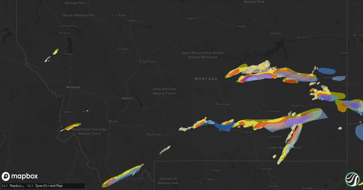
Hail Map in Montana on July 3, 2022
Get this storm
July 3 map
$229
one time, instant access
Download today. No call, no setup
Keep the $229
Bought the map and want the full workflow? Apply the entire $229 to a subscription within 7 days. None of it is wasted.
Every map, not just this one
This buys you this map. Subscription and you get every map we run, in the markets you choose from a few cities to whole states to nationwide. Plus real-time alerts the moment a storm fires.
Contact data
Name, contact info, occupancy, even credit band for addresses in the footprint. You go from where it hit to who to call.
Become the source they trust
Unlimited branding weather history reports on demand. You already have the documented answer ready for the property owner, and you are the one who showed up with it.
Property data and RoofTrace estimates
Pull up any address you have got, its value and the exact code rules for that jurisdiction, straight from One Click Code. Then RoofTrace estimates the squares, pitch, and roof value, priced the way you price.
Storm reports in Montana
Montana
| Date | Description |
|---|---|
| 07/03/20226:55 PM CDT | 7 inch branch blown down. Pictures sent via social media. |
| 07/03/20226:50 PM CDT | Report relayed from facebook. Mostly dime but some quarters mixed in. |
| 07/03/20226:04 PM CDT | Report sent via social media with pictures and video. |
| 07/03/20226:03 PM CDT | 51 mph wind and golf ball size hail. |
| 07/03/20225:04 PM CDT | Luftborough hill dot. |
| 07/03/20224:40 PM CDT | Fence knocked down on property as well. |
| 07/03/20224:25 PM CDT | Picture with measurement of 1 inch hail stones. |
| 07/03/20224:10 PM CDT | Report received via facebook mentioning quarter size hail that ruined their garden. |
| 07/03/20226:17 AM CDT | At 1117 PM MDT, severe thunderstorms were located along a line extending from 10 miles north of Ralph to 10 miles east of Buffalo to 7 miles north of Redig to 6 miles southeast of Gustave, moving southeast at 40 mph. HAZARD...60 mph wind gusts. SOURCE...Radar indicated. IMPACT...Expect damage to roofs, siding, and trees. Locations impacted include... Reva, Ralph, Lodgepole, Sorum, White Butte, Prairie City, Hoover, Redig, Slim Buttes, Sheep Buttes, Haystack Buttes, Crow Buttes and East Short Pines. |
| 07/03/20224:42 AM CDT | At 941 PM MDT, a severe thunderstorm was located 13 miles northeast of Marmarth, or 22 miles west of Amidon, moving east at 30 mph. HAZARD...Golf ball size hail and 70 mph wind gusts. SOURCE...Radar indicated. IMPACT...People and animals outdoors will be injured. Expect hail damage to roofs, siding, windows, and vehicles. Expect considerable tree damage. Wind damage is also likely to mobile homes, roofs, and outbuildings. Locations impacted include... Amidon. |
| 07/03/20224:41 AM CDT | At 941 PM MDT, a severe thunderstorm was located 26 miles west of Baker, moving east at 45 mph. HAZARD...60 mph wind gusts and quarter size hail. SOURCE...Radar indicated. IMPACT...Hail damage to vehicles is expected. Expect wind damage to roofs, siding, and trees. Locations impacted include... Plevna, Ismay, Westmore, Knowlton, Medicine Rocks State Park and Willard.This replaces the warning previously in effect for this area. |
| 07/03/20224:14 AM CDT | At 913 PM MDT, a severe thunderstorm was located near Baker, moving south at 25 mph. HAZARD...70 mph wind gusts and half dollar size hail. SOURCE...Radar indicated. IMPACT...Hail damage to vehicles is expected. Expect considerable tree damage. Wind damage is also likely to mobile homes, roofs, and outbuildings. Locations impacted include... Baker, Webster and Willard. |
| 07/03/20223:47 AM CDT | At 847 PM MDT, a severe thunderstorm was located 11 miles southwest of Carlyle, or 13 miles north of Baker, moving east at 15 mph. HAZARD...70 mph wind gusts and half dollar size hail. SOURCE...Radar indicated. IMPACT...Hail damage to vehicles is expected. Expect considerable tree damage. Wind damage is also likely to mobile homes, roofs, and outbuildings. Locations impacted include... Baker and Ollie. |
| 07/03/20223:40 AM CDT | At 838 PM MDT, severe thunderstorms were located along a line extending from 5 miles west of Skaar to 10 miles northeast of Baker, moving east at 45 mph. HAZARD...70 mph wind gusts and half dollar size hail. SOURCE...Radar indicated. IMPACT...Hail damage to vehicles is expected. Expect considerable tree damage. Wind damage is also likely to mobile homes, roofs, and outbuildings. Severe thunderstorms will be near... Trotters around 855 PM MDT.Other locations in the path of these severe thunderstorms includeAmidon. |
| 07/03/20223:40 AM CDT | At 839 PM MDT, severe thunderstorms were located along a line extending from 22 miles east of Forsyth to 6 miles southeast of Volborg, moving northeast at 50 mph. HAZARD...70 mph wind gusts and ping pong ball size hail. SOURCE...Radar indicated. IMPACT...People and animals outdoors will be injured. Expect hail damage to roofs, siding, windows, and vehicles. Expect considerable tree damage. Wind damage is also likely to mobile homes, roofs, and outbuildings. Locations impacted include... Miles City, Volborg, Locate, Strawberry Hill Recreation Area, Matthews Recreation Area, Hathaway, Twelve Mile Dam, Medicine Rocks State Park, Brandenberg, Garland, Moon Creek Ranch, Mizpah and Knowlton.This replaces the warning previously in effect for this area. |
| 07/03/20222:59 AM CDT | At 759 PM MDT, severe thunderstorms were located along a line extending from 17 miles south of Forsyth to 7 miles southwest of Colstrip, moving east at 45 mph. HAZARD...Ping pong ball size hail and 60 mph wind gusts. SOURCE...Radar indicated. IMPACT...People and animals outdoors will be injured. Expect hail damage to roofs, siding, windows, and vehicles. Expect wind damage to roofs, siding, and trees. Locations impacted include... Colstrip, Brandenberg and Moon Creek Ranch. This replaces the warning previously in effect for this area. |
| 07/03/20222:54 AM CDT | At 753 PM MDT, severe thunderstorms were located along a line extending from near Bloomfield to 20 miles southeast of Fallon, moving east at 40 mph. HAZARD...70 mph wind gusts and half dollar size hail. SOURCE...Radar indicated. IMPACT...Hail damage to vehicles is expected. Expect considerable tree damage. Wind damage is also likely to mobile homes, roofs, and outbuildings. Locations impacted include... Glendive, Wibaux, Fallon, West Glendive, Intake, Carlyle, Hoyt, Saint Phillip, Yates, Hodges, Mildred, Forest Park, Stipek and Marsh. |
| 07/03/20222:53 AM CDT | At 753 PM MDT, a severe thunderstorm was located 17 miles southeast of Ashland, or 28 miles west of Broadus, moving northeast at 35 mph. HAZARD...Ping pong ball size hail and 60 mph wind gusts. SOURCE...Radar indicated. IMPACT...People and animals outdoors will be injured. Expect hail damage to roofs, siding, windows, and vehicles. Expect wind damage to roofs, siding, and trees. Locations impacted include... Volborg. |
| 07/03/20222:26 AM CDT | At 726 PM MDT, a severe thunderstorm was located 25 miles northeast of Sheridan, moving northeast at 25 mph. HAZARD...60 mph wind gusts and half dollar size hail. SOURCE...Radar indicated. IMPACT...Hail damage to vehicles is expected. Expect wind damage to roofs, siding, and trees. Locations impacted include... Birney. |
| 07/03/20222:21 AM CDT | At 721 PM MDT, severe thunderstorms were located along a line extending from 10 miles southeast of Custer to 11 miles northeast of Crow Agency, moving east at 45 mph. HAZARD...70 mph wind gusts and half dollar size hail. SOURCE...Radar indicated. IMPACT...Hail damage to vehicles is expected. Expect considerable tree damage. Wind damage is also likely to mobile homes, roofs, and outbuildings. Locations impacted include... Colstrip, Lame Deer, Busby, Crow Agency, Muddy Cluster and Northern Cheyenne Indian Reservation.This replaces the warning previously in effect for this area. |
| 07/03/20222:09 AM CDT | At 708 PM MDT, a severe thunderstorm was located 26 miles south of Ashland, or 44 miles west of Broadus, moving northeast at 30 mph. HAZARD...60 mph wind gusts and half dollar size hail. SOURCE...Radar indicated. IMPACT...Hail damage to vehicles is expected. Expect wind damage to roofs, siding, and trees. Locations impacted include... Ashland, Otter and Sonnette. |
| 07/03/20222:00 AM CDT | At 700 PM MDT, a severe thunderstorm was located near Hardin, moving southeast at 35 mph. HAZARD...70 mph wind gusts and ping pong ball size hail. SOURCE...Radar indicated. IMPACT...People and animals outdoors will be injured. Expect hail damage to roofs, siding, windows, and vehicles. Expect considerable tree damage. Wind damage is also likely to mobile homes, roofs, and outbuildings. Locations impacted include... Hardin and Crow Agency. |
| 07/03/20221:47 AM CDT | At 646 PM MDT, a severe thunderstorm was located over East Helena, or near Helena, moving northeast at 20 mph. HAZARD...70 mph wind gusts and penny size hail. SOURCE...Radar indicated. IMPACT...Expect considerable tree damage. Damage is likely to mobile homes, roofs, and outbuildings. Locations impacted include... Helena, East Helena, Montana City and York. |
| 07/03/20221:30 AM CDT | At 630 PM MDT, two severe thunderstorms were located near Worden, or 19 miles northeast of Billings, moving east at 30 mph. HAZARD...Golf ball size hail and 70 mph wind gusts. SOURCE...Radar indicated. IMPACT...People and animals outdoors will be injured. Expect hail damage to roofs, siding, windows, and vehicles. Expect considerable tree damage. Wind damage is also likely to mobile homes, roofs, and outbuildings. Locations impacted include... Custer, Shepherd, Huntley, Worden, Ballantine and Pompeys Pillar. This warning does not include the city of Billings.This replaces the warning previously in effect for this area. |
| 07/03/20221:09 AM CDT | At 608 PM MDT, severe thunderstorms were located along a line extending from 9 miles southwest of The Pines Rec Area to 8 miles northeast of Nelson Creek Rec Area to 15 miles southeast of Flowing Wells Rest Area, moving northeast at 30 mph. HAZARD...60 mph wind gusts and quarter size hail. SOURCE...Radar indicated. IMPACT...Hail damage to vehicles is expected. Expect wind damage to roofs, siding, and trees. Locations impacted include... Circle, The Pines Rec Area, Brockway, Flowing Wells Rest Area, Vida, Nelson Creek Rec Area, Lindsay, Rock Creek Rec Area, Van Norman, Mccloud, Haxby, Weldon, Crow Rock and Watkins. |
| 07/03/202212:59 AM CDT | At 559 PM MDT, severe thunderstorms were located along a line extending from 16 miles northwest of Shepherd to 7 miles northwest of Billings Heights, moving northeast at 30 mph. HAZARD...60 mph wind gusts and quarter size hail. SOURCE...Radar indicated. IMPACT...Hail damage to vehicles is expected. Expect wind damage to roofs, siding, and trees. Locations impacted include... Shepherd, Huntley, Worden, Ballantine and Acton. This warning does not include the city of Billings.This replaces the warning previously in effect for this area. |
| 07/03/202212:37 AM CDT | At 536 PM MDT, a severe thunderstorm was located near Laurel, or 13 miles west of Billings, moving southeast at 30 mph. HAZARD...70 mph wind gusts. SOURCE...Radar indicated. IMPACT...Expect considerable tree damage. Damage is likely to mobile homes, roofs, and outbuildings. Locations impacted include... Billings, Laurel, Lockwood, Billings Heights, Billings West End and Huntley. |
| 07/03/202212:25 AM CDT | At 525 PM MDT, severe thunderstorms were located along a line extending from 25 miles northeast of Devils Creek Rec Area to near Hell Creek Rec Area to near Jordan, moving northeast at 30 mph. HAZARD...70 mph wind gusts and quarter size hail. SOURCE...Radar indicated. IMPACT...Hail damage to vehicles is expected. Expect considerable tree damage. Wind damage is also likely to mobile homes, roofs, and outbuildings. Locations impacted include... Jordan, Cohagen, Hell Creek Rec Area and Hillside. |
| 07/03/202212:14 AM CDT | At 513 PM MDT, severe thunderstorms were located along a line extending from 23 miles northeast of Devils Creek Rec Area to near Hell Creek Rec Area to 9 miles north of Cohagen, moving east at 20 mph. HAZARD...70 mph wind gusts and quarter size hail. SOURCE...Radar indicated. IMPACT...Hail damage to vehicles is expected. Expect considerable tree damage. Wind damage is also likely to mobile homes, roofs, and outbuildings. Locations impacted include... The Pines Rec Area, Flowing Wells Rest Area, Nelson Creek Rec Area, Rock Creek Rec Area, Haxby, Crow Rock and Van Norman. |
| 07/03/202212:11 AM CDT | At 509 PM MDT, a severe thunderstorm was located 12 miles west of Big Arm, or 18 miles west of Polson, moving northeast at 20 mph. HAZARD...60 mph wind gusts and quarter size hail. SOURCE...Radar indicated. IMPACT...Hail damage to vehicles is expected. Expect wind damage to roofs, siding, and trees. Locations impacted include... Big Arm, Proctor, Lakeside, Lake Mary Ronan, Elmo, Rollins, Niarada, Dayton and Lonepine. |
| 07/03/202212:00 AM CDT | At 459 PM MDT, a severe thunderstorm was located 22 miles north of Columbus, moving east at 35 mph. HAZARD...Golf ball size hail and 70 mph wind gusts. SOURCE...Radar indicated. IMPACT...People and animals outdoors will be injured. Expect hail damage to roofs, siding, windows, and vehicles. Expect considerable tree damage. Wind damage is also likely to mobile homes, roofs, and outbuildings. Locations impacted include... Broadview, Halfbreed Lake Wildlife, Acton, Hailstone Wildlife Refuge, Rapelje and Comanche.This warning does not include the city of Billings.This replaces the warning previously in effect for this area. |
| 07/02/202211:25 PM CDT | At 425 PM MDT, severe thunderstorms were located along a line extending from 8 miles northwest of Devils Creek Rec Area to 8 miles west of Brusett to near Edwards, moving northeast at 30 mph. THESE ARE DESTRUCTIVE STORMS FOR GARFIELD COUNTY. HAZARD...80 mph wind gusts and quarter size hail. SOURCE...Trained weather spotters. IMPACT...Flying debris will be dangerous to those caught without shelter. Mobile homes will be heavily damaged. Expect considerable damage to roofs, windows, and vehicles. Extensive tree damage and power outages are likely. Locations impacted include... Jordan, Sand Springs, Fourchette, Devils Creek Rec Area, Hell Creek Rec Area, Edwards, Cohagen, Brusett, Hillside and Steve Fork. |
| 07/02/202211:15 PM CDT | At 414 PM MDT, a severe thunderstorm was located near Big Timber, moving east at 25 mph. HAZARD...60 mph wind gusts and half dollar size hail. SOURCE...Radar indicated. IMPACT...Hail damage to vehicles is expected. Expect wind damage to roofs, siding, and trees. This severe thunderstorm will remain over mainly rural areas of north central Stillwater and east central Sweet Grass Counties, including the following locations... Reed Point and Greycliff. |
| 07/02/202210:33 PM CDT | Report via social media. |
| 07/02/202210:32 PM CDT | At 331 PM MDT, severe thunderstorms were located along a line extending from 20 miles west of U L Bend Rec Area to 10 miles southwest of Crooked Creek Rec Area to near Mosby, moving east at 40 mph. HAZARD...60 mph wind gusts and quarter size hail. SOURCE...Radar indicated. IMPACT...Hail damage to vehicles is expected. Expect wind damage to roofs, siding, and trees. Locations impacted include... Sand Springs, Fourchette, Devils Creek Rec Area, U L Bend Rec Area, Edwards, Mosby, Crooked Creek Rec Area, Brusett, Steve Fork and Cat Creek. |
| 07/02/202210:14 PM CDT | At 313 PM MDT, severe thunderstorms were located along a line extending from 6 miles east of Conner to 17 miles north of Gibbonsville, moving east at 30 mph. HAZARD...Ping pong ball size hail and 60 mph wind gusts. SOURCE...Radar indicated. IMPACT...People and animals outdoors will be injured. Expect hail damage to roofs, siding, windows, and vehicles. Expect wind damage to roofs, siding, and trees. Locations impacted include... Sula. |
| 07/02/202210:10 PM CDT | Storm chaser report of quarter sized hail. |
| 07/02/202210:03 PM CDT | Cannonball creek raws. Time estimated from radar. |
| 07/02/20229:55 PM CDT | Storm chaser sent picture of quarter sized hail via social media. |
| 07/02/20229:42 PM CDT | Mesonet site mtbvr. |
| 07/02/20229:15 PM CDT | A local report indicates 1.00 inch wind near 18 SW VOLBORG |
| 07/02/20229:06 PM CDT | Power out and very heavy rain. |
| 07/02/20228:55 PM CDT | At 155 PM MDT, a severe thunderstorm was located 22 miles south of Lima, or 22 miles northwest of Dubois, moving northeast at 25 mph. HAZARD...60 mph wind gusts and quarter size hail. SOURCE...Radar indicated. IMPACT...Hail damage to vehicles is expected. Expect wind damage to roofs, siding, and trees. Locations impacted include... Edie School. |
| 07/02/20228:20 PM CDT | Fort howes raws |
| 07/02/20228:08 PM CDT | Marble to quarter size hail with 50-60 mph winds. |
| 07/02/20228:03 PM CDT | Report relayed via facebook. |
| 07/02/20227:58 PM CDT | A local report indicates 70 MPH wind near 10 NNE MCCLOUD |
| 07/02/20227:48 PM CDT | Pictures from elkview rd of trailer roof destroyed and blown onto road. |
| 07/02/20227:40 PM CDT | Corrects previous non-tstm wnd gst report from 2 e helena. Asos station khln helena airport. |
| 07/02/20227:20 PM CDT | 59 mph wind gust on sunday evening. |
| 07/02/20227:20 PM CDT | Also reported pea-sized hail. |
| 07/02/20227:20 PM CDT | Picture of quarter size hail sent via social media. |
| 07/02/20227:15 PM CDT | A local report indicates 60 MPH wind near 4 ENE HUNTLEY |
All States Impacted by Hail Map on July 3, 2022
Cities Impacted by Hail Map on July 3, 2022
- Brewster, WA
- Quincy, WA
- Malaga, WA
- Rock Island, WA
- Philipsburg, MT
- Cohagen, MT
- Orofino, ID
- Mound City, SD
- Ismay, MT
- Regent, ND
- Mott, ND
- New England, ND
- Hettinger, ND
- Fallon, MT
- Glendive, MT
- Terry, MT
- Max, ND
- Douglas, ND
- Wakpala, SD
- McLaughlin, SD
- Pollock, SD
- Herreid, SD
- Colfax, WA
- Ekalaka, MT
- Interior, SD
- Elgin, ND
- Glen Ullin, ND
- Almont, ND
- Plains, MT
- Wyndmere, ND
- Lidgerwood, ND
- Velva, ND
- Wibaux, MT
- Aberdeen, SD
- Westport, SD
- Lindsay, MT
- Bloomfield, MT
- Deer Park, WA
- Nine Mile Falls, WA
- Leola, SD
- Decker, MT
- Spencer, ID
- Lima, MT
- Dubois, ID
- Cameron, MT
- Bowdle, SD
- Darby, MT
- Volborg, MT
- Pray, MT
- Gardiner, MT
- Livingston, MT
- Huntley, MT
- Sheridan, WY
- Birney, MT
- Hardin, MT
- Worden, MT
- Ballantine, MT
- Colstrip, MT
- Pompeys Pillar, MT
- Bighorn, MT
- Otter, MT
- Forsyth, MT
- Thornton, WA
- Oakesdale, WA
- Jordan, MT
- Midland, SD
- Cresbard, SD
- Long Valley, SD
- Belvidere, SD
- Rhame, ND
- Bowman, ND
- Underwood, MN
- Battle Lake, MN
- Washburn, ND
- Selfridge, ND
- Northville, SD
- Sand Springs, MT
- Brockway, MT
- Brusett, MT
- Winnett, MT
- Mosby, MT
- Underwood, ND
- Kadoka, SD
- Amidon, ND
- Webster, SD
- Pomaria, SC
- White River, SD
- Pine Ridge, SD
- Conner, MT
- Sula, MT
- Rosebud, MT
- Eureka, SD
- Java, SD
- Hot Springs, MT
- Lonepine, MT
- Ludlow, SD
- Billings, MT
- Shepherd, MT
- Acton, MT
- Colville, WA
- Long Lake, SD
- Chamberlain, SD
- Hamill, SD
- Gregory, SD
- Graettinger, IA
- Bridgeport, TX
- Wilmington, NC
- Philip, SD
- Wall, SD
- Pukwana, SD
- Model, CO
- Jacksboro, TX
- Bowie, TX
- Ward, CO
- Jamestown, CO
- Windthorst, TX
- Scotland, TX
- Henrietta, TX
- Dodd City, TX
- Windom, TX
- Honey Grove, TX
- Forestburg, TX
- Alvord, TX
- Jerico Springs, MO
- New Underwood, SD
- Bishopville, SC
- Hartsville, SC
- McBee, SC
- Saint Jo, TX
- Muenster, TX
- Chico, TX
- Ryan, OK
- Ringling, OK
- Nocona, TX
- Marietta, OK
- Fort Scott, KS
- Bertrand, NE
- Waldo, KS
- Paradise, KS
- Russell, KS
- Arcadia, NE
- Ipswich, SD
- New Bern, NC
- Cave Springs, AR
- Springdale, AR
- Lowell, AR
- Rogers, AR
- Bentonville, AR
- Early Branch, SC
- Throckmorton, TX
- Seymour, TX
- Willard, MO
- Le Roy, KS
- Roscoe, SD
- Hosmer, SD
- Yemassee, SC
- Colony, KS
- Tolstoy, SD
- Ree Heights, SD
- Highmore, SD
- Miller, SD
- Campbell, NE
- Bladen, NE
- Murdo, SD
- Clarkton, NC
- Bladenboro, NC
- Norris, SD
- Martin, SD
- Wichita Falls, TX
- Wolsey, SD
- Big Timber, MT
- Ryegate, MT
- Melville, MT
- Rapelje, MT
- Reed Point, MT
- Draper, SD
- Porcupine, SD
- Wounded Knee, SD
- Wanblee, SD
- Batesland, SD
- Allen, SD
- Kyle, SD
- Wasta, SD
- Scenic, SD
- Owanka, SD
- Goodland, KS
- Pilot Point, TX
- Tioga, TX
- Alpena, SD
- Woonsocket, SD
- Neodesha, KS
- Altoona, KS
- Buffalo, KS
- Benedict, KS
- Fredonia, KS
- Glenvil, NE
- Hastings, NE
- Inland, NE
- Ayr, NE
- Curtis, NE
- Moorefield, NE
- Okaton, SD
- Cleo Springs, OK
- Nevada, MO
- Arcadia, KS
- Elizabethtown, NC
- Greensboro, GA
- Union Point, GA
- Bryson, TX
- Lindsay, NE
- Bellevue, TX
- Gainesville, TX
- Tuthill, SD
- Mcdonough, GA
- Concord, GA
- Molena, GA
- Huron, SD
- Oacoma, SD
- Yates Center, KS
- Carthage, SD
- Artesian, SD
- Sturgis, SD
- Fort Meade, SD
- Kennebec, SD
- Fort Myers, FL
- Lakemont, GA
- Tiger, GA
- Troy, NC
- Lewellen, NE
- Chappell, NE
- Oshkosh, NE
- Big Springs, NE
- Graniteville, SC
- Auburntown, TN
- Liberty, TN
- Alexandria, TN
- Ruby, SC
- Chesterfield, SC
- Nashville, TN
- Randlett, OK
- Delco, NC
- Westphalia, KS
- Burlington, KS
- Waverly, KS
- Fergus Falls, MN
- Dalton, MN
- Loving, TX
- Neosho Falls, KS
- Electra, TX
- Broadview, MT
- Rapid City, SD
- Piedmont, SD
- Farnam, NE
- Stockville, NE
- Maywood, NE
- Wellfleet, NE
- Hayes Center, NE
- Ridgeway, SC
- Ottawa, KS
- Dalzell, SC
- Rembert, SC
- Graysville, TN
- Presho, SD
- Vivian, SD
- Richmond, KS
- Garnett, KS
- Durant, OK
- Faulkton, SD
- Leland, NC
- Kimball, SD
- White Lake, SD
- Wessington Springs, SD
- Scottsbluff, NE
- Gann Valley, SD
- Plankinton, SD
- Cove City, NC
- Pomona, KS
- Watkinsville, GA
- Bishop, GA
- Millen, GA
- Dulce, NM
- Magnolia, NC
- Warsaw, NC
- Hookerton, NC
- Grifton, NC
- Minatare, NE
- Holliday, TX
- Elizabeth City, NC
- Roseland, NE
- Eden, SD
- Opelika, AL
- Redfield, SD
- Brentford, SD
- Ashton, SD
- Conde, SD
- Doland, SD
- Turton, SD
- Frankfort, SD
- Mellette, SD
- Sanger, TX
- Monroe, NC
- Pageland, SC
- Molt, MT
- Dalton, NE
- Lisco, NE
- Wood, SD
- Lumberton, NC
- Oak Ridge, TN
- Valley View, TX
- Sherman, TX
- Missouri Valley, IA
- Logan, IA
- Kinston, NC
- Manderson, SD
- Piqua, KS
- Evergreen, NC
- Chadbourn, NC
- Upland, NE
- Minden, NE
- Franklin, NE
- Bloomington, NE
- Hildreth, NE
- Harvard, NE
- Athens, GA
- South Mills, NC
- Virgil, SD
- Wessington, SD
- Oakes, ND
- Cogswell, ND
- Reliance, SD
- Lower Brule, SD
- Fayetteville, NC
- White Oak, NC
- Hiawassee, GA
- Ellsworth, NE
- Bingham, NE
- Riverton, NE
- Galivants Ferry, SC
- Marion, SC
- Gresham, SC
- Blossom, TX
- Jefferson, SC
- Ringgold, TX
- Millry, AL
- Saint Lawrence, SD
- Loco, OK
- Deadwood, SD
- Clarks Hill, SC
- Caputa, SD
- Fort Pierre, SD
- Quinn, SD
- Fedora, SD
- Iroquois, SD
- Cavour, SD
- Albion, NE
- Comstock, NE
- Westerville, NE
- Ansley, NE
- Rosston, TX
- Blair, SC
- Paradise, TX
- Rutledge, GA
- Madison, GA
- Lamar, SC
- Lance Creek, WY
- Kershaw, SC
- Ringgold, GA
- Mitchell, NE
- Edgemont, SD
- Columbus, KS
- Scammon, KS
- Fruitdale, AL
- Vinegar Bend, AL
- Monroe, GA
- Good Hope, GA
- Milo, MO
- Conyers, GA
- Onaka, SD
- Hooper, NE
- Mullins, SC
- Wrightsville Beach, NC
- Ashley, ND
- Cayuga, ND
- Rockham, SD
- Dewy Rose, GA
- Saint Pauls, NC
- Poolville, TX
- Fayetteville, AR
- Naponee, NE
- Bogart, GA
- Statham, GA
- Omaha, NE
- Addy, WA
- Strandquist, MN
- Newfolden, MN
- New Leipzig, ND
- Pendleton, OR
- Estelline, SD
- Henning, MN
- Brule, NE
- Plevna, MT
- Baker, MT
- Willard, MT
- Milesville, SD
- Groton, SD
- Warner, SD
- Andover, SD
- Mansfield, SD
- Stratford, SD
- Bath, SD
- Ferney, SD
- Reva, SD
- Buffalo, SD
- Raymond, SD
- Grand Island, NE
- Polson, MT
- Custer, MT
- Marmarth, ND
- Mullen, NE
- Sutherland, NE
- Arthur, NE
- Tryon, NE
- Lemoyne, NE
- Doniphan, NE
- Chapman, NE
- Phillips, NE
- Alda, NE
- Black Hawk, SD
- Enning, SD
- Howes, SD
- Carson, ND
- Scranton, ND
- Reeder, ND
- Dickinson, ND


