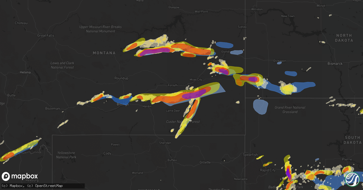
Hail Map on July 3, 2022
Get this storm
July 3 map
$229
one time, instant access
Download today. No call, no setup
Keep the $229
Bought the map and want the full workflow? Apply the entire $229 to a subscription within 7 days. None of it is wasted.
Every map, not just this one
This buys you this map. Subscription and you get every map we run, in the markets you choose from a few cities to whole states to nationwide. Plus real-time alerts the moment a storm fires.
Contact data
Name, contact info, occupancy, even credit band for addresses in the footprint. You go from where it hit to who to call.
Become the source they trust
Unlimited branding weather history reports on demand. You already have the documented answer ready for the property owner, and you are the one who showed up with it.
Property data and RoofTrace estimates
Pull up any address you have got, its value and the exact code rules for that jurisdiction, straight from One Click Code. Then RoofTrace estimates the squares, pitch, and roof value, priced the way you price.
States Impacted by Hail Map on July 3, 2022
Storm reports
South Dakota
| Date | Description |
|---|---|
| 07/03/20226:35 PM CDT | Mostly smaller... But some up to quarter sized. Also estimated wind gusts up to 50 mph. |
| 07/03/20226:08 PM CDT | Time estimated via radar |
| 07/03/20225:56 PM CDT | A local report indicates 2.00 inch wind near WASTA |
| 07/03/20225:53 PM CDT | A local report indicates 1.25 inch wind near 1 E STURGIS |
| 07/03/20225:52 PM CDT | A local report indicates 1.00 inch wind near 1 SSW STURGIS |
| 07/03/20225:50 PM CDT | A local report indicates 2.75 inch wind near 5 S WASTA |
| 07/03/20225:50 PM CDT | A local report indicates 1.00 inch wind near 1 SW STURGIS |
| 07/03/20225:45 PM CDT | A local report indicates 60 MPH wind near 2 SSW PHILIP |
| 07/03/20225:45 PM CDT | A local report indicates 1.00 inch wind near 2 SSW PHILIP |
| 07/03/20225:28 PM CDT | 30-40 mph winds with the hail |
| 07/03/20225:00 PM CDT | A local report indicates 1.00 inch wind near 6 NE SUMMERSET |
| 07/03/20224:48 PM CDT | A local report indicates 63 MPH wind near 10 W EDGEMONT |
| 07/03/20224:43 PM CDT | A local report indicates 65 MPH wind near 10 W EDGEMONT |
| 07/03/20224:38 PM CDT | A local report indicates 65 MPH wind near 10 W EDGEMONT |
| 07/03/20224:33 PM CDT | A local report indicates 59 MPH wind near 10 W EDGEMONT |
| 07/03/20224:30 PM CDT | A local report indicates 1.00 inch wind near SUMMERSET |
| 07/03/20224:17 PM CDT | Mesonet station 6 sd rwis forestburg. |
| 07/03/20224:06 PM CDT | A local report indicates 1.00 inch wind near 8 E ALPENA |
| 07/03/20223:58 PM CDT | Sanborn county sheriff reports damage to 7 power poles along hwy 34 - 6 are broken and the last is cracked. |
| 07/03/20222:58 PM CDT | Wind damage to a large portion of a mature tree. Radar estimated time. |
| 07/03/20222:54 PM CDT | A local report indicates 1.50 inch wind near 2 WSW WOLSEY |
| 07/03/202212:18 PM CDT | In addition to hail and strong winds... Heavy rain was also reported but not measured yet. |
| 07/03/202212:18 PM CDT | In addition to strong winds... Heavy rain was also reported but not measured yet. |
| 07/03/20227:02 AM CDT | At 1201 PM CDT, a severe thunderstorm was located 7 miles east of Gann Valley, or 17 miles north of Kimball, moving east at 30 mph. HAZARD...60 mph wind gusts and quarter size hail. SOURCE...Radar indicated. IMPACT...Hail damage to vehicles is expected. Expect wind damage to roofs, siding, and trees. Locations impacted include... Wessington Springs, Lane and Storla. |
| 07/03/20226:57 AM CDT | At 1157 PM CDT/1057 PM MDT/, a severe thunderstorm was located 10 miles north of 5 Mile Corner, or 11 miles northwest of Presho, moving east at 35 mph. HAZARD...60 mph wind gusts. SOURCE...Radar indicated. IMPACT...Expect damage to roofs, siding, and trees. This severe thunderstorm will be near... Fate Dam around 1210 AM CDT. Cedar Creek Rec Area around 1215 AM CDT.Other locations in the path of this severe thunderstorm include ByreLake and Joe Creek Rec Area. |
| 07/03/20226:39 AM CDT | At 1138 PM CDT, a severe thunderstorm was located near Mina, or 13 miles southeast of Ipswich, moving east at 25 mph. HAZARD...60 mph wind gusts and nickel size hail. SOURCE...Radar indicated. IMPACT...Expect damage to roofs, siding, and trees. This severe thunderstorm will remain over mainly rural areas of eastern Edmunds and southwestern Brown Counties. |
| 07/03/20226:35 AM CDT | At 1134 PM CDT, a severe thunderstorm was located near Cedar Butte, or 10 miles west of White River, moving east at 40 mph. HAZARD...60 mph wind gusts. SOURCE...Radar indicated. IMPACT...Expect damage to roofs, siding, and trees. Locations impacted include... Intersection of Highway 83 and White River. |
| 07/03/20226:06 AM CDT | At 1106 PM CDT/1006 PM MDT/, a severe thunderstorm was located near Capa, or 21 miles northwest of Murdo, moving east at 30 mph. HAZARD...60 mph wind gusts. SOURCE...Radar indicated. IMPACT...Expect damage to roofs, siding, and trees. This severe thunderstorm will be near... Capa around 1110 PM CDT.Other locations in the path of this severe thunderstorm include VanMetre. |
| 07/03/20225:59 AM CDT | At 1059 PM CDT, a severe thunderstorm was located near Ipswich, moving east at 30 mph. HAZARD...Half dollar size hail. SOURCE...Radar indicated. IMPACT...Damage to vehicles is expected. This severe thunderstorm will be near... Ipswich around 1105 PM CDT. Pembrook Colony around 1110 PM CDT.Other locations in the path of this severe thunderstorm includeCravens Corner, Mina and Mina Lake Rec Area. |
| 07/03/20225:27 AM CDT | At 1027 PM CDT, a severe thunderstorm was located near Cedar Creek Rec Area, or 15 miles northwest of Lower Brule, moving east at 25 mph. HAZARD...60 mph wind gusts. SOURCE...Radar indicated. IMPACT...Expect damage to roofs, siding, and trees. This severe thunderstorm will be near... Joe Creek Rec Area around 1035 PM CDT. West Bend Rec Area around 1045 PM CDT.Other locations in the path of this severe thunderstorm include LowerBrule. |
| 07/03/20225:27 AM CDT | At 1027 PM MDT/1127 PM CDT/, severe thunderstorms were located along a line extending from 6 miles south of Nowlin to 5 miles southeast of Belvidere to 2 miles northeast of Corn Creek, moving east at 40 mph. HAZARD...60 mph wind gusts and penny size hail. SOURCE...Radar indicated. IMPACT...Expect damage to roofs, siding, and trees. Severe thunderstorms will be near... Cedar Butte around 1140 PM CDT. Midland around 1045 PM MDT.Other locations in the path of these severe thunderstorms includeSwift Bear and White River.This includes Interstate 90 in South Dakota between Mile Markers 158and 174. |
| 07/03/20224:42 AM CDT | At 942 PM CDT, a severe thunderstorm was located 13 miles southwest of Rousseau, or 15 miles south of Pierre, moving east at 30 mph. HAZARD...60 mph wind gusts. SOURCE...Radar indicated. IMPACT...Expect damage to roofs, siding, and trees. Locations impacted include... Cedar Creek Rec Area, Degrey Rec Area and Joe Creek Rec Area. |
| 07/03/20224:21 AM CDT | At 921 PM MDT, severe thunderstorms were located along a line extending from 2 miles north of Potato Creek to 5 miles northeast of Yellow Bear Canyon to 2 miles south of Wakpamni, moving east at 30 mph. HAZARD...70 mph wind gusts. SOURCE...Radar indicated. IMPACT...Expect considerable tree damage. Damage is likely to mobile homes, roofs, and outbuildings. Severe thunderstorms will be near... Potato Creek, Allen and Snake Butte around 925 PM MDT.Other locations in the path of these severe thunderstorms includeHisle, Eagle Nest Butte, Wanblee, Martin, Long Valley, George Town,Lacreek Wildlife Refuge, Sunrise Housing and Tuthill. |
| 07/03/20224:15 AM CDT | At 915 PM CDT, a severe thunderstorm was located near Hillsview, or 10 miles southeast of Eureka, moving northeast at 10 mph. HAZARD...Ping pong ball size hail and 60 mph wind gusts. SOURCE...Radar indicated. IMPACT...People and animals outdoors will be injured. Expect hail damage to roofs, siding, windows, and vehicles. Expect wind damage to roofs, siding, and trees. Locations impacted include... New Town Corner. |
| 07/03/20224:15 AM CDT | At 915 PM MDT, severe thunderstorms were located along a line extending from 4 miles southeast of Grindstone to 3 miles southwest of Philip to 9 miles east of Cactus Flat, moving northeast at 30 mph. HAZARD...60 mph wind gusts. SOURCE...Radar indicated. IMPACT...Expect damage to roofs, siding, and trees. Severe thunderstorms will be near... Philip around 920 PM MDT. Kadoka and Grindstone Butte around 935 PM MDT.Other locations in the path of these severe thunderstorms includeOttumwa, Nowlin and Midland.This includes Interstate 90 in South Dakota between Mile Markers 134and 156. |
| 07/03/20222:14 AM CDT | At 713 PM CDT/613 PM MDT/, a severe thunderstorm was located near Midland, or 22 miles northwest of Murdo, moving east at 30 mph. HAZARD...Two inch hail and 60 mph wind gusts. SOURCE...Radar indicated. IMPACT...People and animals outdoors will be injured. Expect hail damage to roofs, siding, windows, and vehicles. Expect wind damage to roofs, siding, and trees. This severe thunderstorm will be near... Capa around 730 PM CDT.Other locations in the path of this severe thunderstorm include VanMetre. |
| 07/03/20222:03 AM CDT | At 702 PM CDT, a severe thunderstorm was located near Pembrook Colony, or 11 miles south of Ipswich, moving northeast at 20 mph. HAZARD...60 mph wind gusts and quarter size hail. SOURCE...Radar indicated. IMPACT...Hail damage to vehicles is expected. Expect wind damage to roofs, siding, and trees. This severe thunderstorm will be near... Pembrook Colony around 710 PM CDT. |
| 07/03/20221:26 AM CDT | Grain leg at the local grain elevator tipped over. Estimated time base of radar data. |
| 07/03/202212:46 AM CDT | Mesonet station 285 14w lower brule |
| 07/03/202212:46 AM CDT | At 546 AM CDT, a severe thunderstorm was located near Virgil, or 7 miles southwest of Huron, moving southeast at 35 mph. HAZARD...60 mph wind gusts and half dollar size hail. SOURCE...Radar indicated. IMPACT...Hail damage to vehicles is expected. Expect wind damage to roofs, siding, and trees. This severe thunderstorm will be near... Huron around 550 AM CDT. Cavour around 605 AM CDT. |
| 07/03/202212:39 AM CDT | At 539 PM MDT, a severe thunderstorm was located 6 miles southwest of Nowlin, or 11 miles northeast of Kadoka, moving east at 20 mph. HAZARD...Golf ball size hail and 60 mph wind gusts. SOURCE...Radar indicated. IMPACT...People and animals outdoors will be injured. Expect hail damage to roofs, siding, windows, and vehicles. Expect wind damage to roofs, siding, and trees. This severe thunderstorm will be near... Nowlin around 555 PM MDT.Other locations in the path of this severe thunderstorm includeMidland.This includes Interstate 90 in South Dakota between Mile Markers 172and 174. |
| 07/03/202212:37 AM CDT | At 537 AM CDT, a severe thunderstorm was located 7 miles south of Bryant, or 11 miles north of Lake Thompson State Recreation Area, moving east at 30 mph. HAZARD...Quarter size hail. SOURCE...Radar indicated. IMPACT...Damage to vehicles is expected. This severe thunderstorm will be near... Badger around 605 AM CDT.Other locations impacted by this severe thunderstorm include Erwin. |
| 07/03/202212:24 AM CDT | At 524 PM MDT, a severe thunderstorm was located 3 miles west of Rockyford, or 30 miles north of Pine Ridge, moving east at 25 mph. HAZARD...Ping pong ball size hail and 60 mph wind gusts. SOURCE...Radar indicated. IMPACT...People and animals outdoors will be injured. Expect hail damage to roofs, siding, windows, and vehicles. Expect wind damage to roofs, siding, and trees. This severe thunderstorm will be near... Rockyford around 535 PM MDT. Thunder Valley around 540 PM MDT.Other locations in the path of this severe thunderstorm include Kyleand Kyle North Route Housing. |
| 07/03/202212:21 AM CDT | At 521 PM MDT, a severe thunderstorm was located 6 miles south of Elm Springs, or 39 miles east of Rapid City, moving north at 20 mph. HAZARD...60 mph wind gusts and half dollar size hail. SOURCE...Radar indicated. IMPACT...Hail damage to vehicles is expected. Expect wind damage to roofs, siding, and trees. This severe thunderstorm will be near... Elm Springs around 540 PM MDT. |
| 07/03/202212:16 AM CDT | Mesonet station 175 mellette |
| 07/03/202212:14 AM CDT | Fort pierre raws. |
| 07/03/202212:10 AM CDT | Asos station kabr aberdeen rgnl ap. |
| 07/03/202212:10 AM CDT | Corrects previous tstm wnd gst report from aberdeen regional airport to add that a mature tree was pushed over near 10th avenue and park street in aberdeen. |
| 07/03/202212:08 AM CDT | A local report indicates 61 MPH wind near 1 N BUFFALO |
| 07/03/202212:02 AM CDT | At 501 AM MDT, a severe thunderstorm was located near Hayes, or 31 miles west of Fort Pierre, moving northeast at 20 mph. HAZARD...60 mph wind gusts and quarter size hail. SOURCE...Radar indicated. IMPACT...Hail damage to vehicles is expected. Expect wind damage to roofs, siding, and trees. This severe thunderstorm will be near... Hayes around 505 AM MDT. |
| 07/02/202211:49 PM CDT | A local report indicates 60 MPH wind near 6 NNW MANSFIELD |
| 07/02/202211:48 PM CDT | At 448 PM MDT, a severe thunderstorm was located over Fort Meade, or over Sturgis, moving east at 10 mph. HAZARD...Quarter size hail. SOURCE...Radar indicated. IMPACT...Damage to vehicles is expected. Locations impacted include... Sturgis, Fort Meade and Bear Butte State Park. This includes Interstate 90 in South Dakota between Mile Markers 29and 35. |
| 07/02/202211:42 PM CDT | Mesonet station 13 vivian |
| 07/02/202211:41 PM CDT | At 440 PM MDT, a severe thunderstorm was located over Philip, moving east at 10 mph. HAZARD...Golf ball size hail and 60 mph wind gusts. SOURCE...Radar indicated. IMPACT...People and animals outdoors will be injured. Expect hail damage to roofs, siding, windows, and vehicles. Expect wind damage to roofs, siding, and trees. This severe thunderstorm will remain over mainly rural areas of south central Haakon and north central Jackson Counties. |
| 07/02/202211:41 PM CDT | At 441 PM CDT, a severe thunderstorm was located over Carthage, or 18 miles southwest of Lake Thompson State Recreation Area, moving east at 25 mph. HAZARD...70 mph wind gusts and quarter size hail. SOURCE...Radar indicated. IMPACT...Hail damage to vehicles is expected. Expect considerable tree damage. Wind damage is also likely to mobile homes, roofs, and outbuildings. This severe thunderstorm will be near... Vilas around 455 PM CDT.Other locations in the path of this severe thunderstorm includeHoward, Winfred and Oldham. |
| 07/02/202211:29 PM CDT | At 428 PM MDT, a severe thunderstorm was located 8 miles southeast of Owanka, or 39 miles east of Rapid City, moving north at 15 mph. THIS IS A DESTRUCTIVE STORM FOR WASTA AND WICKSVILLE. HAZARD...Baseball size hail and 60 mph wind gusts. SOURCE...Radar indicated. IMPACT...People and animals outdoors will be severely injured. Expect shattered windows, extensive damage to roofs, siding, and vehicles. Locations impacted include... Owanka, Wasta and Wicksville.This includes Interstate 90 in South Dakota between Mile Markers 87and 106. |
| 07/02/202211:20 PM CDT | Mesonet station 173 craven |
| 07/02/202211:19 PM CDT | Telephone call report. |
| 07/02/202211:00 PM CDT | At 400 PM MDT, severe thunderstorms were located along a line extending from Badlands National Park to 6 miles northwest of Rockyford, moving northeast at 20 mph. HAZARD...60 mph wind gusts and half dollar size hail. SOURCE...Radar indicated. IMPACT...Hail damage to vehicles is expected. Expect wind damage to roofs, siding, and trees. Severe thunderstorms will be near... Scenic around 405 PM MDT. Sheep Mountain Table around 420 PM MDT.Other locations in the path of these severe thunderstorms includeBadlands National Park, Pinnacles Ranger Station, Wall, Quinn andDelta 9 Missile Silo.This includes Interstate 90 in South Dakota between Mile Markers 86and 128. |
| 07/02/202211:00 PM CDT | At 400 PM CDT, a severe thunderstorm was located near Alpena, or 14 miles south of Huron, moving east at 35 mph. HAZARD...Tennis ball size hail and 70 mph wind gusts. SOURCE...Radar indicated. IMPACT...People and animals outdoors will be injured. Expect hail damage to roofs, siding, windows, and vehicles. Expect considerable tree damage. Wind damage is also likely to mobile homes, roofs, and outbuildings. This severe thunderstorm will be near... Forestburg around 420 PM CDT.Other locations in the path of this severe thunderstorm includeArtesian, Carthage, Fedora and Roswell. |
| 07/02/202210:49 PM CDT | At 349 PM MDT, a severe thunderstorm was located 4 miles east of Cottonwood, or 8 miles southwest of Philip, moving east at 15 mph. HAZARD...Ping pong ball size hail and 60 mph wind gusts. SOURCE...Radar indicated. IMPACT...People and animals outdoors will be injured. Expect hail damage to roofs, siding, windows, and vehicles. Expect wind damage to roofs, siding, and trees. Locations impacted include... Philip. |
| 07/02/202210:47 PM CDT | At 346 PM MDT, a severe thunderstorm was located 4 miles northeast of Summerset, or 10 miles north of Rapid City, moving east at 15 mph. HAZARD...60 mph wind gusts and half dollar size hail. SOURCE...Radar indicated. IMPACT...Hail damage to vehicles is expected. Expect wind damage to roofs, siding, and trees. This severe thunderstorm will be near... Ellsworth Air Force Base around 405 PM MDT.This includes Interstate 90 in South Dakota between Mile Markers 43and 53. |
| 07/02/202210:41 PM CDT | At 341 PM MDT, a severe thunderstorm was located 6 miles west of Edgemont, moving east at 20 mph. HAZARD...Ping pong ball size hail and 60 mph wind gusts. SOURCE...Radar indicated. IMPACT...People and animals outdoors will be injured. Expect hail damage to roofs, siding, windows, and vehicles. Expect wind damage to roofs, siding, and trees. This severe thunderstorm will be near... Edgemont around 400 PM MDT.Other locations in the path of this severe thunderstorm includeCascade Falls and Cottonwood Springs Dam. |
| 07/02/202210:28 PM CDT | At 327 PM CDT, a severe thunderstorm was located near St. Lawrence, or near Miller, moving east at 25 mph. HAZARD...60 mph wind gusts and half dollar size hail. SOURCE...Radar indicated. IMPACT...Hail damage to vehicles is expected. Expect wind damage to roofs, siding, and trees. This severe thunderstorm will be near... Vayland around 340 PM CDT. |
| 07/02/202210:23 PM CDT | At 323 PM CDT, a severe thunderstorm was located near Virgil, or 14 miles west of Huron, moving east at 30 mph. HAZARD...60 mph wind gusts and half dollar size hail. SOURCE...Radar indicated. IMPACT...Hail damage to vehicles is expected. Expect wind damage to roofs, siding, and trees. This severe thunderstorm will be near... Virgil around 335 PM CDT.Other locations in the path of this severe thunderstorm includeAlpena, Huron and Woonsocket. |
| 07/02/202210:05 PM CDT | A local report indicates 63 MPH wind near 2 E COTTONWOOD |
| 07/02/202210:05 PM CDT | Mesonet station 185 blunt |
| 07/02/202210:03 PM CDT | At 303 PM MDT, a severe thunderstorm was located over Lonesome Valley, or 27 miles north of Pine Ridge, moving east at 20 mph. HAZARD...Ping pong ball size hail and 60 mph wind gusts. SOURCE...Radar indicated. IMPACT...People and animals outdoors will be injured. Expect hail damage to roofs, siding, windows, and vehicles. Expect wind damage to roofs, siding, and trees. This severe thunderstorm will be near... Thunder Valley and Sharps Corner around 320 PM MDT.Other locations in the path of this severe thunderstorm include KyleNorth Route Housing and Kyle. |
| 07/02/20229:54 PM CDT | At 254 PM CDT, a severe thunderstorm was located over Wolsey, or 14 miles west of Huron, moving northeast at 25 mph. HAZARD...60 mph wind gusts and quarter size hail. SOURCE...Radar indicated. IMPACT...Hail damage to vehicles is expected. Expect wind damage to roofs, siding, and trees. This severe thunderstorm will be near... Wolsey around 300 PM CDT.Other locations in the path of this severe thunderstorm includeHuron. |
| 07/02/20229:49 PM CDT | At 249 PM CDT, a severe thunderstorm was located over Ree Heights, or 10 miles east of Highmore, moving east at 25 mph. HAZARD...60 mph wind gusts and half dollar size hail. SOURCE...Radar indicated. IMPACT...Hail damage to vehicles is expected. Expect wind damage to roofs, siding, and trees. Locations impacted include... Miller and St. Lawrence. |
| 07/02/20229:42 PM CDT | Mesonet station 13 vivian |
| 07/02/20229:28 PM CDT | At 227 AM CDT, a severe thunderstorm was located near Oacoma, or near Chamberlain, moving east at 35 mph. HAZARD...60 mph wind gusts and penny size hail. SOURCE...Radar indicated. IMPACT...Expect damage to roofs, siding, and trees. This severe thunderstorm will remain over mainly rural areas of northern Brule County, including the following locations... Pukwana. |
| 07/02/20229:25 PM CDT | A local report indicates 60 MPH wind near 1 NE MIDLAND |
| 07/02/20229:13 PM CDT | A local report indicates 1.25 inch wind near LEOLA |
| 07/02/20228:39 PM CDT | At 138 AM CDT, a severe thunderstorm was located near Earling Hill, or 7 miles southeast of Presho, moving east at 30 mph. HAZARD...60 mph wind gusts and penny size hail. SOURCE...Radar indicated. IMPACT...Expect damage to roofs, siding, and trees. This severe thunderstorm will be near... Kennebec and Byre Lake around 150 AM CDT.Other locations in the path of this severe thunderstorm includeLyman, Reliance and Medicine Butte. |
| 07/02/20228:12 PM CDT | A local report indicates 59 MPH wind near 10 NNW OTTUMWA |
| 07/02/20228:04 PM CDT | At 104 AM CDT/1204 AM MDT/, a severe thunderstorm was located near Pierre, moving east at 40 mph. HAZARD...60 mph wind gusts. SOURCE...Radar indicated. IMPACT...Expect damage to roofs, siding, and trees. This severe thunderstorm will be near... Rousseau around 115 AM CDT. Canning around 120 AM CDT.Other locations in the path of this severe thunderstorm includeDegrey Rec Area and Harrold. |
| 07/02/20227:19 PM CDT | 50 to 60 mph wind gusts. Radar-estimated time. |
Kansas
| Date | Description |
|---|---|
| 07/03/20226:45 PM CDT | Sherman county kansas mesonet site reported 59 mph gust. |
| 07/03/20223:02 AM CDT | At 802 PM CDT, a severe thunderstorm was located 14 miles north of Brewster, moving northeast at 25 mph. HAZARD...60 mph wind gusts. SOURCE...Radar indicated. IMPACT...Expect damage to roofs, siding, and trees. This severe thunderstorm will remain over mainly rural areas of northwestern Thomas and southwestern Rawlins Counties. |
| 07/03/20222:57 AM CDT | At 756 PM CDT, severe thunderstorms were located along a line extending from 9 miles south of Hendley to 3 miles northwest of Norton to near Clayton, moving northeast at 45 mph. HAZARD...70 mph wind gusts and nickel size hail. SOURCE...Radar indicated. IMPACT...Expect considerable tree damage. Damage is likely to mobile homes, roofs, and outbuildings. Severe thunderstorms will be near... Norton around 815 PM CDT. Almena around 830 PM CDT.Other locations impacted by these severe thunderstorms include Reagerand Calvert. |
| 07/02/20227:05 PM CDT | Report of power poles blown down at location received. Time estimated by radar. |
| 07/02/20227:00 PM CDT | Power lines blown down in the road 14 between road 60 and 61 reported via social media. Time estimated by reporter. |
| 07/02/20227:00 PM CDT | Power lines reported down between rd 13 and 14 on road 59. Hog hut also blown 30 feet and a t-post was bent. Time estimated by reporter. |
| 07/02/20227:00 PM CDT | City of oberlin reported to have lost power when thunderstorm passed. Exact location of damaged power poles unknown at this time. |
| 07/02/20227:00 PM CDT | Report received of power poles down on road 11 back west relayed via dispatch. |
South Carolina
| Date | Description |
|---|---|
| 07/03/20223:20 PM CDT | Spotter reported quarter size hail and estimated 60 mph wind gust near graniteville saint hill fire department. |
| 07/03/20221:28 AM CDT | At 627 PM EDT, a severe thunderstorm was located over Kellytown, or near Hartsville, and is nearly stationary. HAZARD...60 mph wind gusts and quarter size hail. SOURCE...Radar indicated. IMPACT...Hail damage to vehicles is expected. Expect wind damage to trees and powerlines. Locations impacted include... Ashland. |
| 07/03/20221:01 AM CDT | At 601 PM EDT, a severe thunderstorm was located near Carolina Sandhills Wildlife Refuge, or 14 miles north of Hartsville, moving east at 10 mph. HAZARD...60 mph wind gusts and nickel size hail. SOURCE...Radar indicated. IMPACT...Expect damage to trees and powerlines. Locations impacted include... Carolina Sandhills Wildlife Refuge, Patrick, Bay Springs Fire Station, Alligator Fire Station and Middendorf. |
| 07/03/202212:42 AM CDT | At 541 PM EDT, a severe thunderstorm was located over Yemassee, moving northwest at 10 mph. HAZARD...60 mph wind gusts and penny size hail. SOURCE...Radar indicated. IMPACT...Expect damage to trees and powerlines. Locations impacted include: Yemassee, Islandton, Early Branch, Cummings, McPhersonville, Grays, Almeda Intersection and Pocotaligo.This warning includes I-95 in South Carolina between mile markers 31and 47. |
| 07/02/202211:06 PM CDT | At 405 PM EDT, a severe thunderstorm was located near Graniteville, or near Belvedere, and is nearly stationary. HAZARD...60 mph wind gusts and quarter size hail. SOURCE...Radar indicated. IMPACT...Hail damage to vehicles is expected. Expect wind damage to trees and powerlines. Locations impacted include... Aiken, North Augusta, Clearwater, Belvedere, USC Aiken, Gloverville, Graniteville, Burnettown, Trenton, Hopeland Gardens, Poverty Hill, Murphys Estates, Vaucluse and Murphy Village.This includes the following highways... Interstate 20 in South Carolina between mile markers 2 and 20. Interstate 520 in South Carolina between mile markers 18 and 23. |
North Carolina
| Date | Description |
|---|---|
| 07/03/20224:43 PM CDT | Farmers reported gusts estimated at 60 mph. |
| 07/03/20224:38 PM CDT | Tree down near elizabeth city. |
| 07/03/20224:13 PM CDT | Trees down near south mills. |
| 07/03/20224:13 PM CDT | Roof blown off of the russel auto parts store near south mills. |
| 07/03/20222:01 AM CDT | At 701 PM EDT, a severe thunderstorm was located over Macedonia, or over Hiawassee, moving southeast at 10 mph. HAZARD...60 mph wind gusts and quarter size hail. SOURCE...Radar indicated. IMPACT...Hail damage to vehicles is expected. Expect wind damage to roofs, siding, and trees. Locations impacted include... Hiawassee, Tate City, Macedonia, Plum Orchard Gap Shelter, Titus and Mountain Scene. |
| 07/03/202212:37 AM CDT | At 537 PM EDT, a severe thunderstorm was located near Badin Lake, moving southeast at 5 mph. HAZARD...60 mph wind gusts and quarter size hail. SOURCE...Radar indicated. IMPACT...Hail damage to vehicles is expected. Expect wind damage to roofs, siding, and trees. Locations impacted include... Albemarle, Troy, Badin Lake, Biscoe, Norwood, Badin, Mount Gilead, Star, Candor and Uwharrie Haven. |
| 07/03/202212:15 AM CDT | At 514 PM EDT, a severe thunderstorm was located near Elizabeth City, moving southeast at 30 mph. HAZARD...60 mph wind gusts and quarter size hail. SOURCE...Radar indicated. IMPACT...Minor damage to vehicles is possible. Expect wind damage to trees and powerlines. This severe thunderstorm will be near... Elizabeth City around 520 PM EDT. Camden and Elizabeth City State University around 525 PM EDT. Whitehall Shores around 530 PM EDT. Shiloh and Nixonton around 535 PM EDT. Weeksville around 540 PM EDT. Old Trap around 545 PM EDT.Other locations impacted by this severe thunderstorm include BobWhite Fork, Belcross, Holiday Island, Rabbit Corner, Stevenson Point,Symonds Creek, Listers Corner, Parkville, Woodville and Glen Cove. |
| 07/03/202212:13 AM CDT | At 512 PM EDT, a severe thunderstorm was located near Grifton, or near Ayden, moving southeast at 15 mph. HAZARD...60 mph wind gusts and quarter size hail. SOURCE...Radar indicated. IMPACT...Hail damage to vehicles is expected. Expect wind damage to roofs, siding, and trees. Locations impacted include... Greenville, Ayden, Grifton, Graingers, Roundtree, Ormondsville, Hookerton and Gardnerville. |
| 07/03/202212:00 AM CDT | At 500 PM EDT, a severe thunderstorm was located over Phoenix, or near Leland, and is nearly stationary. HAZARD...60 mph wind gusts and quarter size hail. SOURCE...Radar indicated. IMPACT...Minor hail damage to vehicles is possible. Expect wind damage to trees and power lines. Locations impacted include... Leland, Northwest, Batarora, Bishop, Town Creek, Phoenix, Winnabow, Belville, Navassa and Sandy Creek. |
Florida
| Date | Description |
|---|---|
| 07/03/20222:30 PM CDT | Delayed report. 911 call center reports power lines down from wind. |
| 07/03/20222:29 PM CDT | Delayed report. Power lines down due to winds. |
| 07/03/20222:23 PM CDT | Delayed report. Power lines down due to winds. |
| 07/02/202210:06 PM CDT | At 306 PM EDT, a severe thunderstorm was located over Juniper Springs, moving south at 10 mph. HAZARD...60 mph wind gusts. SOURCE...Radar indicated. IMPACT...Expect damage to roofs, siding, and trees. Locations impacted include... Juniper Springs. |
| 07/02/20229:59 PM CDT | At 258 PM EDT, a severe thunderstorm was located near Palm Coast, moving south at 10 mph. HAZARD...60 mph wind gusts. SOURCE...Radar indicated. IMPACT...Expect damage to roofs, siding, and trees. Locations impacted include... Palm Coast, Bunnell and Espanola. |
Montana
| Date | Description |
|---|---|
| 07/03/20226:55 PM CDT | 7 inch branch blown down. Pictures sent via social media. |
| 07/03/20226:50 PM CDT | Report relayed from facebook. Mostly dime but some quarters mixed in. |
| 07/03/20226:04 PM CDT | Report sent via social media with pictures and video. |
| 07/03/20226:03 PM CDT | 51 mph wind and golf ball size hail. |
| 07/03/20225:04 PM CDT | Luftborough hill dot. |
| 07/03/20224:40 PM CDT | Fence knocked down on property as well. |
| 07/03/20224:25 PM CDT | Picture with measurement of 1 inch hail stones. |
| 07/03/20224:10 PM CDT | Report received via facebook mentioning quarter size hail that ruined their garden. |
| 07/03/20226:17 AM CDT | At 1117 PM MDT, severe thunderstorms were located along a line extending from 10 miles north of Ralph to 10 miles east of Buffalo to 7 miles north of Redig to 6 miles southeast of Gustave, moving southeast at 40 mph. HAZARD...60 mph wind gusts. SOURCE...Radar indicated. IMPACT...Expect damage to roofs, siding, and trees. Locations impacted include... Reva, Ralph, Lodgepole, Sorum, White Butte, Prairie City, Hoover, Redig, Slim Buttes, Sheep Buttes, Haystack Buttes, Crow Buttes and East Short Pines. |
| 07/03/20224:42 AM CDT | At 941 PM MDT, a severe thunderstorm was located 13 miles northeast of Marmarth, or 22 miles west of Amidon, moving east at 30 mph. HAZARD...Golf ball size hail and 70 mph wind gusts. SOURCE...Radar indicated. IMPACT...People and animals outdoors will be injured. Expect hail damage to roofs, siding, windows, and vehicles. Expect considerable tree damage. Wind damage is also likely to mobile homes, roofs, and outbuildings. Locations impacted include... Amidon. |
| 07/03/20224:41 AM CDT | At 941 PM MDT, a severe thunderstorm was located 26 miles west of Baker, moving east at 45 mph. HAZARD...60 mph wind gusts and quarter size hail. SOURCE...Radar indicated. IMPACT...Hail damage to vehicles is expected. Expect wind damage to roofs, siding, and trees. Locations impacted include... Plevna, Ismay, Westmore, Knowlton, Medicine Rocks State Park and Willard.This replaces the warning previously in effect for this area. |
| 07/03/20224:14 AM CDT | At 913 PM MDT, a severe thunderstorm was located near Baker, moving south at 25 mph. HAZARD...70 mph wind gusts and half dollar size hail. SOURCE...Radar indicated. IMPACT...Hail damage to vehicles is expected. Expect considerable tree damage. Wind damage is also likely to mobile homes, roofs, and outbuildings. Locations impacted include... Baker, Webster and Willard. |
| 07/03/20223:47 AM CDT | At 847 PM MDT, a severe thunderstorm was located 11 miles southwest of Carlyle, or 13 miles north of Baker, moving east at 15 mph. HAZARD...70 mph wind gusts and half dollar size hail. SOURCE...Radar indicated. IMPACT...Hail damage to vehicles is expected. Expect considerable tree damage. Wind damage is also likely to mobile homes, roofs, and outbuildings. Locations impacted include... Baker and Ollie. |
| 07/03/20223:40 AM CDT | At 839 PM MDT, severe thunderstorms were located along a line extending from 22 miles east of Forsyth to 6 miles southeast of Volborg, moving northeast at 50 mph. HAZARD...70 mph wind gusts and ping pong ball size hail. SOURCE...Radar indicated. IMPACT...People and animals outdoors will be injured. Expect hail damage to roofs, siding, windows, and vehicles. Expect considerable tree damage. Wind damage is also likely to mobile homes, roofs, and outbuildings. Locations impacted include... Miles City, Volborg, Locate, Strawberry Hill Recreation Area, Matthews Recreation Area, Hathaway, Twelve Mile Dam, Medicine Rocks State Park, Brandenberg, Garland, Moon Creek Ranch, Mizpah and Knowlton.This replaces the warning previously in effect for this area. |
| 07/03/20223:40 AM CDT | At 838 PM MDT, severe thunderstorms were located along a line extending from 5 miles west of Skaar to 10 miles northeast of Baker, moving east at 45 mph. HAZARD...70 mph wind gusts and half dollar size hail. SOURCE...Radar indicated. IMPACT...Hail damage to vehicles is expected. Expect considerable tree damage. Wind damage is also likely to mobile homes, roofs, and outbuildings. Severe thunderstorms will be near... Trotters around 855 PM MDT.Other locations in the path of these severe thunderstorms includeAmidon. |
| 07/03/20222:59 AM CDT | At 759 PM MDT, severe thunderstorms were located along a line extending from 17 miles south of Forsyth to 7 miles southwest of Colstrip, moving east at 45 mph. HAZARD...Ping pong ball size hail and 60 mph wind gusts. SOURCE...Radar indicated. IMPACT...People and animals outdoors will be injured. Expect hail damage to roofs, siding, windows, and vehicles. Expect wind damage to roofs, siding, and trees. Locations impacted include... Colstrip, Brandenberg and Moon Creek Ranch. This replaces the warning previously in effect for this area. |
| 07/03/20222:54 AM CDT | At 753 PM MDT, severe thunderstorms were located along a line extending from near Bloomfield to 20 miles southeast of Fallon, moving east at 40 mph. HAZARD...70 mph wind gusts and half dollar size hail. SOURCE...Radar indicated. IMPACT...Hail damage to vehicles is expected. Expect considerable tree damage. Wind damage is also likely to mobile homes, roofs, and outbuildings. Locations impacted include... Glendive, Wibaux, Fallon, West Glendive, Intake, Carlyle, Hoyt, Saint Phillip, Yates, Hodges, Mildred, Forest Park, Stipek and Marsh. |
| 07/03/20222:53 AM CDT | At 753 PM MDT, a severe thunderstorm was located 17 miles southeast of Ashland, or 28 miles west of Broadus, moving northeast at 35 mph. HAZARD...Ping pong ball size hail and 60 mph wind gusts. SOURCE...Radar indicated. IMPACT...People and animals outdoors will be injured. Expect hail damage to roofs, siding, windows, and vehicles. Expect wind damage to roofs, siding, and trees. Locations impacted include... Volborg. |
| 07/03/20222:26 AM CDT | At 726 PM MDT, a severe thunderstorm was located 25 miles northeast of Sheridan, moving northeast at 25 mph. HAZARD...60 mph wind gusts and half dollar size hail. SOURCE...Radar indicated. IMPACT...Hail damage to vehicles is expected. Expect wind damage to roofs, siding, and trees. Locations impacted include... Birney. |
| 07/03/20222:21 AM CDT | At 721 PM MDT, severe thunderstorms were located along a line extending from 10 miles southeast of Custer to 11 miles northeast of Crow Agency, moving east at 45 mph. HAZARD...70 mph wind gusts and half dollar size hail. SOURCE...Radar indicated. IMPACT...Hail damage to vehicles is expected. Expect considerable tree damage. Wind damage is also likely to mobile homes, roofs, and outbuildings. Locations impacted include... Colstrip, Lame Deer, Busby, Crow Agency, Muddy Cluster and Northern Cheyenne Indian Reservation.This replaces the warning previously in effect for this area. |
| 07/03/20222:09 AM CDT | At 708 PM MDT, a severe thunderstorm was located 26 miles south of Ashland, or 44 miles west of Broadus, moving northeast at 30 mph. HAZARD...60 mph wind gusts and half dollar size hail. SOURCE...Radar indicated. IMPACT...Hail damage to vehicles is expected. Expect wind damage to roofs, siding, and trees. Locations impacted include... Ashland, Otter and Sonnette. |
| 07/03/20222:00 AM CDT | At 700 PM MDT, a severe thunderstorm was located near Hardin, moving southeast at 35 mph. HAZARD...70 mph wind gusts and ping pong ball size hail. SOURCE...Radar indicated. IMPACT...People and animals outdoors will be injured. Expect hail damage to roofs, siding, windows, and vehicles. Expect considerable tree damage. Wind damage is also likely to mobile homes, roofs, and outbuildings. Locations impacted include... Hardin and Crow Agency. |
| 07/03/20221:47 AM CDT | At 646 PM MDT, a severe thunderstorm was located over East Helena, or near Helena, moving northeast at 20 mph. HAZARD...70 mph wind gusts and penny size hail. SOURCE...Radar indicated. IMPACT...Expect considerable tree damage. Damage is likely to mobile homes, roofs, and outbuildings. Locations impacted include... Helena, East Helena, Montana City and York. |
| 07/03/20221:30 AM CDT | At 630 PM MDT, two severe thunderstorms were located near Worden, or 19 miles northeast of Billings, moving east at 30 mph. HAZARD...Golf ball size hail and 70 mph wind gusts. SOURCE...Radar indicated. IMPACT...People and animals outdoors will be injured. Expect hail damage to roofs, siding, windows, and vehicles. Expect considerable tree damage. Wind damage is also likely to mobile homes, roofs, and outbuildings. Locations impacted include... Custer, Shepherd, Huntley, Worden, Ballantine and Pompeys Pillar. This warning does not include the city of Billings.This replaces the warning previously in effect for this area. |
| 07/03/20221:09 AM CDT | At 608 PM MDT, severe thunderstorms were located along a line extending from 9 miles southwest of The Pines Rec Area to 8 miles northeast of Nelson Creek Rec Area to 15 miles southeast of Flowing Wells Rest Area, moving northeast at 30 mph. HAZARD...60 mph wind gusts and quarter size hail. SOURCE...Radar indicated. IMPACT...Hail damage to vehicles is expected. Expect wind damage to roofs, siding, and trees. Locations impacted include... Circle, The Pines Rec Area, Brockway, Flowing Wells Rest Area, Vida, Nelson Creek Rec Area, Lindsay, Rock Creek Rec Area, Van Norman, Mccloud, Haxby, Weldon, Crow Rock and Watkins. |
| 07/03/202212:59 AM CDT | At 559 PM MDT, severe thunderstorms were located along a line extending from 16 miles northwest of Shepherd to 7 miles northwest of Billings Heights, moving northeast at 30 mph. HAZARD...60 mph wind gusts and quarter size hail. SOURCE...Radar indicated. IMPACT...Hail damage to vehicles is expected. Expect wind damage to roofs, siding, and trees. Locations impacted include... Shepherd, Huntley, Worden, Ballantine and Acton. This warning does not include the city of Billings.This replaces the warning previously in effect for this area. |
| 07/03/202212:37 AM CDT | At 536 PM MDT, a severe thunderstorm was located near Laurel, or 13 miles west of Billings, moving southeast at 30 mph. HAZARD...70 mph wind gusts. SOURCE...Radar indicated. IMPACT...Expect considerable tree damage. Damage is likely to mobile homes, roofs, and outbuildings. Locations impacted include... Billings, Laurel, Lockwood, Billings Heights, Billings West End and Huntley. |
| 07/03/202212:25 AM CDT | At 525 PM MDT, severe thunderstorms were located along a line extending from 25 miles northeast of Devils Creek Rec Area to near Hell Creek Rec Area to near Jordan, moving northeast at 30 mph. HAZARD...70 mph wind gusts and quarter size hail. SOURCE...Radar indicated. IMPACT...Hail damage to vehicles is expected. Expect considerable tree damage. Wind damage is also likely to mobile homes, roofs, and outbuildings. Locations impacted include... Jordan, Cohagen, Hell Creek Rec Area and Hillside. |
| 07/03/202212:14 AM CDT | At 513 PM MDT, severe thunderstorms were located along a line extending from 23 miles northeast of Devils Creek Rec Area to near Hell Creek Rec Area to 9 miles north of Cohagen, moving east at 20 mph. HAZARD...70 mph wind gusts and quarter size hail. SOURCE...Radar indicated. IMPACT...Hail damage to vehicles is expected. Expect considerable tree damage. Wind damage is also likely to mobile homes, roofs, and outbuildings. Locations impacted include... The Pines Rec Area, Flowing Wells Rest Area, Nelson Creek Rec Area, Rock Creek Rec Area, Haxby, Crow Rock and Van Norman. |
| 07/03/202212:11 AM CDT | At 509 PM MDT, a severe thunderstorm was located 12 miles west of Big Arm, or 18 miles west of Polson, moving northeast at 20 mph. HAZARD...60 mph wind gusts and quarter size hail. SOURCE...Radar indicated. IMPACT...Hail damage to vehicles is expected. Expect wind damage to roofs, siding, and trees. Locations impacted include... Big Arm, Proctor, Lakeside, Lake Mary Ronan, Elmo, Rollins, Niarada, Dayton and Lonepine. |
| 07/03/202212:00 AM CDT | At 459 PM MDT, a severe thunderstorm was located 22 miles north of Columbus, moving east at 35 mph. HAZARD...Golf ball size hail and 70 mph wind gusts. SOURCE...Radar indicated. IMPACT...People and animals outdoors will be injured. Expect hail damage to roofs, siding, windows, and vehicles. Expect considerable tree damage. Wind damage is also likely to mobile homes, roofs, and outbuildings. Locations impacted include... Broadview, Halfbreed Lake Wildlife, Acton, Hailstone Wildlife Refuge, Rapelje and Comanche.This warning does not include the city of Billings.This replaces the warning previously in effect for this area. |
| 07/02/202211:25 PM CDT | At 425 PM MDT, severe thunderstorms were located along a line extending from 8 miles northwest of Devils Creek Rec Area to 8 miles west of Brusett to near Edwards, moving northeast at 30 mph. THESE ARE DESTRUCTIVE STORMS FOR GARFIELD COUNTY. HAZARD...80 mph wind gusts and quarter size hail. SOURCE...Trained weather spotters. IMPACT...Flying debris will be dangerous to those caught without shelter. Mobile homes will be heavily damaged. Expect considerable damage to roofs, windows, and vehicles. Extensive tree damage and power outages are likely. Locations impacted include... Jordan, Sand Springs, Fourchette, Devils Creek Rec Area, Hell Creek Rec Area, Edwards, Cohagen, Brusett, Hillside and Steve Fork. |
| 07/02/202211:15 PM CDT | At 414 PM MDT, a severe thunderstorm was located near Big Timber, moving east at 25 mph. HAZARD...60 mph wind gusts and half dollar size hail. SOURCE...Radar indicated. IMPACT...Hail damage to vehicles is expected. Expect wind damage to roofs, siding, and trees. This severe thunderstorm will remain over mainly rural areas of north central Stillwater and east central Sweet Grass Counties, including the following locations... Reed Point and Greycliff. |
| 07/02/202210:33 PM CDT | Report via social media. |
| 07/02/202210:32 PM CDT | At 331 PM MDT, severe thunderstorms were located along a line extending from 20 miles west of U L Bend Rec Area to 10 miles southwest of Crooked Creek Rec Area to near Mosby, moving east at 40 mph. HAZARD...60 mph wind gusts and quarter size hail. SOURCE...Radar indicated. IMPACT...Hail damage to vehicles is expected. Expect wind damage to roofs, siding, and trees. Locations impacted include... Sand Springs, Fourchette, Devils Creek Rec Area, U L Bend Rec Area, Edwards, Mosby, Crooked Creek Rec Area, Brusett, Steve Fork and Cat Creek. |
| 07/02/202210:14 PM CDT | At 313 PM MDT, severe thunderstorms were located along a line extending from 6 miles east of Conner to 17 miles north of Gibbonsville, moving east at 30 mph. HAZARD...Ping pong ball size hail and 60 mph wind gusts. SOURCE...Radar indicated. IMPACT...People and animals outdoors will be injured. Expect hail damage to roofs, siding, windows, and vehicles. Expect wind damage to roofs, siding, and trees. Locations impacted include... Sula. |
| 07/02/202210:10 PM CDT | Storm chaser report of quarter sized hail. |
| 07/02/202210:03 PM CDT | Cannonball creek raws. Time estimated from radar. |
| 07/02/20229:55 PM CDT | Storm chaser sent picture of quarter sized hail via social media. |
| 07/02/20229:42 PM CDT | Mesonet site mtbvr. |
| 07/02/20229:15 PM CDT | A local report indicates 1.00 inch wind near 18 SW VOLBORG |
| 07/02/20229:06 PM CDT | Power out and very heavy rain. |
| 07/02/20228:55 PM CDT | At 155 PM MDT, a severe thunderstorm was located 22 miles south of Lima, or 22 miles northwest of Dubois, moving northeast at 25 mph. HAZARD...60 mph wind gusts and quarter size hail. SOURCE...Radar indicated. IMPACT...Hail damage to vehicles is expected. Expect wind damage to roofs, siding, and trees. Locations impacted include... Edie School. |
| 07/02/20228:20 PM CDT | Fort howes raws |
| 07/02/20228:08 PM CDT | Marble to quarter size hail with 50-60 mph winds. |
| 07/02/20228:03 PM CDT | Report relayed via facebook. |
| 07/02/20227:58 PM CDT | A local report indicates 70 MPH wind near 10 NNE MCCLOUD |
| 07/02/20227:48 PM CDT | Pictures from elkview rd of trailer roof destroyed and blown onto road. |
| 07/02/20227:40 PM CDT | Corrects previous non-tstm wnd gst report from 2 e helena. Asos station khln helena airport. |
| 07/02/20227:20 PM CDT | Also reported pea-sized hail. |
| 07/02/20227:20 PM CDT | 59 mph wind gust on sunday evening. |
| 07/02/20227:20 PM CDT | Picture of quarter size hail sent via social media. |
| 07/02/20227:15 PM CDT | A local report indicates 60 MPH wind near 4 ENE HUNTLEY |
Georgia
| Date | Description |
|---|---|
| 07/03/20226:04 PM CDT | Tree and powerlines down s dogwood road and pine st |
| 07/03/20226:04 PM CDT | Tree down at konahetah dr and konahetah rd |
| 07/03/20225:59 PM CDT | Two trees down at massedonia rd near watson springs rd and price rd |
| 07/03/20225:40 PM CDT | Tree and power lines on road at jacks creek rd and old good hope rd |
| 07/03/20225:35 PM CDT | Tree down on hwy 78 at pete dickens rd |
| 07/03/20225:12 PM CDT | 1 large oak tree down on anna dr north of annas walk. |
| 07/03/20225:07 PM CDT | Ping pong sized hail reported by caller in athens... Ga. |
| 07/03/20225:03 PM CDT | Tree down on beaverdam road at beaver trail |
| 07/03/20224:30 PM CDT | Tree down at revel cove dr and lancaster creek cir |
| 07/03/20224:26 PM CDT | Tree down at meadowbrook dr and meadowbrook cir |
| 07/03/20224:21 PM CDT | Tree down at east mccarty st and n hospital rd |
| 07/03/20224:21 PM CDT | Powerlines down at fall line fwy and deepstep rd |
| 07/03/20222:12 PM CDT | Power line down on pricemill rd near paxson dairy rd |
| 07/03/20222:07 PM CDT | Tree down at dixie highway and wilson rd. |
| 07/03/20221:58 PM CDT | Tree down at 400 block of cotter rd |
| 07/03/20221:58 PM CDT | Tree down at poplar springs and oak st and tree down at baggett rd and john drive |
| 07/03/20221:30 PM CDT | Tree down at park stree and indiana street |
| 07/03/20221:29 PM CDT | Tree down 900 block cherokee trail near rossville |
| 07/03/20222:20 AM CDT | At 720 PM EDT, a severe thunderstorm was located over Adrian, or 10 miles north of Soperton, and is nearly stationary. HAZARD...60 mph wind gusts and quarter size hail. SOURCE...Radar indicated. IMPACT...Hail damage to vehicles is expected. Expect wind damage to roofs, siding, and trees. Locations impacted include... Adrian, Norristown Junction, Covena, Meeks, Orland, Orianna, Blackville, Norristown, Gillis Springs and Scott. |
| 07/03/20221:46 AM CDT | At 646 PM EDT, a severe thunderstorm was located over Union Point, or near Greensboro, and is nearly stationary. HAZARD...60 mph wind gusts and quarter size hail. SOURCE...Radar indicated. IMPACT...Hail damage to vehicles is expected. Expect wind damage to roofs, siding, and trees. Locations impacted include... Greensboro, Crawfordville, Union Point, Woodville, White Plains, Siloam, Maxeys, Stephens, Veazey, Robinson, Daniel Springs, Penfield, Lyneville and Alexander Stephens Park. |
| 07/03/20221:32 AM CDT | At 632 PM EDT, a severe thunderstorm was located near Bostwick, or 9 miles southwest of Watkinsville, and is nearly stationary. HAZARD...60 mph wind gusts and quarter size hail. SOURCE...Radar indicated. IMPACT...Hail damage to vehicles is expected. Expect wind damage to roofs, siding, and trees. Locations impacted include... Monroe, North High Shoals, Bostwick, Good Hope, Bishop, Ebenezer, Gratis, Eastville, Farmington, Apalachee, Campton and Hard Labor Creek State Park. |
| 07/03/20221:01 AM CDT | At 601 PM EDT, a severe thunderstorm was located over Madison, and is nearly stationary. HAZARD...60 mph wind gusts and quarter size hail. SOURCE...Radar indicated. IMPACT...Hail damage to vehicles is expected. Expect wind damage to roofs, siding, and trees. Locations impacted include... Madison, Buckhead, Godfrey, Parks Mill and Swords. |
| 07/03/202212:55 AM CDT | At 554 PM EDT, a severe thunderstorm was located over Swainsboro, and is nearly stationary. HAZARD...60 mph wind gusts and quarter size hail. SOURCE...Radar indicated. IMPACT...Hail damage to vehicles is expected. Expect wind damage to roofs, siding, and trees. Locations impacted include... Swainsboro, Kite, Norristown Junction, Dellwood, Covena, Modoc and Norristown. |
| 07/03/202212:45 AM CDT | At 544 PM EDT, a severe thunderstorm was located over Bogart, or 7 miles northwest of Watkinsville, and is nearly stationary. HAZARD...60 mph wind gusts and quarter size hail. SOURCE...Radar indicated. IMPACT...Hail damage to vehicles is expected. Expect wind damage to roofs, siding, and trees. Locations impacted include... Watkinsville, Statham, Bogart, North High Shoals, Bostwick, Bishop, Athens-Clarke County, Whitehall, Westgate Park, Beechwood Hills, Oconee Heights, Eastville, Barnett Shoals, State Botanical Garden Of Ga, Farmington and Bear Creek Reservoir. |
| 07/03/202212:41 AM CDT | At 540 PM EDT, a severe thunderstorm was located near Molena, or 9 miles west of Zebulon, and is nearly stationary. HAZARD...60 mph wind gusts and quarter size hail. SOURCE...Radar indicated. IMPACT...Hail damage to vehicles is expected. Expect wind damage to roofs, siding, and trees. Locations impacted include... Zebulon, Woodbury, Molena, Meansville, Gay, Hilltop, Lifsey Springs, Imlac and Hollonville. |
| 07/03/202212:37 AM CDT | At 537 PM EDT, a severe thunderstorm was located over Jenkinsburg, or near Jackson, and is nearly stationary. HAZARD...60 mph wind gusts and quarter size hail. SOURCE...Radar indicated. IMPACT...Hail damage to vehicles is expected. Expect wind damage to roofs, siding, and trees. Locations impacted include... Jackson, Locust Grove, Flovilla, Jenkinsburg, Ola, Worthville, McKibben, Indian Springs State Park and Stark. |
| 07/03/202212:33 AM CDT | At 533 PM EDT, a severe thunderstorm was located over Oak Hill, or 8 miles northeast of McDonough, and is nearly stationary. HAZARD...60 mph wind gusts and quarter size hail. SOURCE...Radar indicated. IMPACT...Hail damage to vehicles is expected. Expect wind damage to roofs, siding, and trees. Locations impacted include... Covington, Porterdale, Fincherville, Oak Hill and Rocky Plains. |
| 07/03/202212:28 AM CDT | At 527 PM EDT, a severe thunderstorm was located over Arabia Mountain, or near Conyers, and is nearly stationary. HAZARD...60 mph wind gusts and quarter size hail. SOURCE...Radar indicated. IMPACT...Hail damage to vehicles is expected. Expect wind damage to roofs, siding, and trees. Locations impacted include... Conyers, Lithonia, Lakeview Estates, Georgia International Horse Park, Magnet, Milstead, Richardson Park, Arabia Mountain and Redan. |
| 07/03/202212:17 AM CDT | At 517 PM EDT, a severe thunderstorm was located over Sandersville, and is nearly stationary. HAZARD...60 mph wind gusts and quarter size hail. SOURCE...Radar indicated. IMPACT...Hail damage to vehicles is expected. Expect wind damage to roofs, siding, and trees. Locations impacted include... Sandersville, Davisboro, Tennille, Oconee and Riddleville. |
| 07/03/202212:14 AM CDT | At 514 PM EDT, a severe thunderstorm was located over Payne, or over Macon, and is nearly stationary. HAZARD...60 mph wind gusts and quarter size hail. SOURCE...Radar indicated. IMPACT...Hail damage to vehicles is expected. Expect wind damage to roofs, siding, and trees. Locations impacted include... Macon, Payne, Payne City, Cross Keys, Wesleyan and Arkwright. |
| 07/03/202212:08 AM CDT | At 508 PM EDT, a severe thunderstorm was located over Hilltop, or near Zebulon, and is nearly stationary. HAZARD...60 mph wind gusts and quarter size hail. SOURCE...Radar indicated. IMPACT...Hail damage to vehicles is expected. Expect wind damage to roofs, siding, and trees. Locations impacted include... Zebulon, Meansville, Lifsey Springs and Hilltop. |
| 07/03/202212:05 AM CDT | At 505 PM EDT, a severe thunderstorm was located over Huber, or 7 miles southeast of Macon, and is nearly stationary. HAZARD...60 mph wind gusts and quarter size hail. SOURCE...Radar indicated. IMPACT...Hail damage to vehicles is expected. Expect wind damage to roofs, siding, and trees. Locations impacted include... Macon, Warner Robins, Robins Air Force Base, Marion, Rutland, Fitzpatrick, Ripley, Huber, Dry Branch, Elberta, Franklinton, Middle Georgia Regional Airport and Bullard. |
| 07/03/202212:03 AM CDT | At 502 PM EDT, a severe thunderstorm was located over Snapfinger, or 9 miles southeast of Decatur, and is nearly stationary. HAZARD...60 mph wind gusts and quarter size hail. SOURCE...Radar indicated. IMPACT...Hail damage to vehicles is expected. Expect wind damage to roofs, siding, and trees. Locations impacted include... Lithonia, Belvedere Park, Candler-Mcafee, Hidden Valley Park, Panola Mountain State Park, Belmont, Richardson Park, Arabia Mountain, Redan, Snapfinger and Panthersville. |
| 07/02/202211:55 PM CDT | At 455 PM EDT, a severe thunderstorm was located over Conyers, and is nearly stationary. HAZARD...60 mph wind gusts and quarter size hail. SOURCE...Radar indicated. IMPACT...Hail damage to vehicles is expected. Expect wind damage to roofs, siding, and trees. Locations impacted include... Conyers, Covington, Oxford, Porterdale, Lakeview Estates, Georgia International Horse Park, Magnet, Gum Creek, Almon, Milstead, Oak Hill and Rocky Plains. |
| 07/02/202211:52 PM CDT | At 452 PM EDT, a severe thunderstorm was located near Liberty Hill, or near Barnesville, and is nearly stationary. HAZARD...60 mph wind gusts and quarter size hail. SOURCE...Radar indicated. IMPACT...Hail damage to vehicles is expected. Expect wind damage to roofs, siding, and trees. Locations impacted include... Barnesville, Milner, Aldora, High Falls State Park, Blount, Liberty Hill, Goggins, Collier, Johnstonville, Brent and Chappel Mill. |
| 07/02/202211:20 PM CDT | At 420 PM EDT, a severe thunderstorm was located over Jonesboro, moving southeast at 10 mph. HAZARD...60 mph wind gusts and quarter size hail. SOURCE...Radar indicated. IMPACT...Hail damage to vehicles is expected. Expect wind damage to roofs, siding, and trees. Locations impacted include... McDonough, Jonesboro, Stockbridge, Forest Park, Riverdale, Hampton, Morrow, Lovejoy, Lake City, Lake Spivey, Blacksville, Rex, Ellenwood, Fort Gillem, Bonanza, Luella, Atlanta Motor Speedway, Flippen, Eagles Landing and Irondale. |
| 07/02/202211:12 PM CDT | At 412 PM EDT, a severe thunderstorm was located over The Rock, or near Thomaston, moving southeast at 5 mph. HAZARD...60 mph wind gusts and quarter size hail. SOURCE...Radar indicated. IMPACT...Hail damage to vehicles is expected. Expect wind damage to roofs, siding, and trees. Locations impacted include... Thomaston, Yatesville, Culloden, The Rock, Lincoln Park, Redbone, Logtown, Redbone Crossroads, Hannahs Mill, Piedmont and Salem. |
| 07/02/20229:25 PM CDT | At 225 PM EDT, a severe thunderstorm was located 7 miles southeast of Clayton, or 6 miles northeast of Tallulah Gorge State Park, moving southeast at 10 mph. HAZARD...60 mph wind gusts and quarter size hail. SOURCE...Radar indicated. IMPACT...Minor hail damage to vehicles is expected. Expect wind damage to trees and power lines. Locations impacted include... Clayton, Tiger, Lakemont, Tallulah Gorge State Park, Oconee State Park, Mountain Rest, Long Creek, Mountain City and Tallulah Falls. |
Kentucky
| Date | Description |
|---|---|
| 07/03/20221:53 AM CDT | At 653 AM EDT, a severe thunderstorm was located over Lone, or near Booneville, moving southeast at 25 mph. HAZARD...60 mph wind gusts and quarter size hail. SOURCE...Radar indicated. IMPACT...Hail damage to vehicles is expected. Expect wind damage to roofs, siding, and trees. This severe thunderstorm will be near... Jetts Creek around 700 AM EDT. Turkey around 705 AM EDT. Houston around 710 AM EDT.Other locations in the path of this severe thunderstorm includeCanoe, Talbert and Whick. |
| 07/03/20221:29 AM CDT | At 628 AM EDT, a severe thunderstorm was located over Meally, or near Paintsville, moving southeast at 20 mph. HAZARD...60 mph wind gusts and quarter size hail. SOURCE...Radar indicated. IMPACT...Hail damage to vehicles is expected. Expect wind damage to roofs, siding, and trees. This severe thunderstorm will be near... Odds around 635 AM EDT. Dicks Creek around 645 AM EDT.Other locations in the path of this severe thunderstorm includePleasant and Moree. |
Minnesota
| Date | Description |
|---|---|
| 07/03/202212:35 AM CDT | At 534 PM CDT, a severe thunderstorm was located near Wendell, or 17 miles south of Fergus Falls, moving northeast at 35 mph. HAZARD...60 mph wind gusts and quarter size hail. SOURCE...Radar indicated. IMPACT...Hail damage to vehicles is expected. Expect wind damage to roofs, siding, and trees. This severe thunderstorm will be near... Wendell around 540 PM CDT. Western around 545 PM CDT.Other locations in the path of this severe thunderstorm includeDalton.This includes Interstate 94 in Minnesota between mile markers 55 and73. |
| 07/02/20227:20 PM CDT | Mainly dime to nickel size hail. Measured some quarter size hail. |
| 07/02/20227:20 PM CDT | Mainly dime and nickel size hail. Measured some quarter size hail. |
Colorado
| Date | Description |
|---|---|
| 07/03/202212:24 AM CDT | At 524 PM MDT, a severe thunderstorm was located over Bennett, or 28 miles east of Denver, moving east at 20 mph. HAZARD...60 mph wind gusts. SOURCE...Radar indicated. IMPACT...Expect damage to roofs, siding, and trees. This severe thunderstorm will be near... Strasburg around 540 PM MDT.Other locations in the path of this severe thunderstorm includeByers. |
Tennessee
| Date | Description |
|---|---|
| 07/02/202210:29 PM CDT | At 328 PM EDT, a severe thunderstorm was located over Oak Ridge, moving south at 15 mph. HAZARD...60 mph wind gusts and quarter size hail. SOURCE...Radar indicated. IMPACT...Hail damage to vehicles is expected. Expect wind damage to roofs, siding, and trees. Locations impacted include... Oak Ridge, Lenoir City, Loudon, Farragut, Philadelphia, Bradbury and Tellico Village.This includes the following highways... Interstate 40 in Tennessee between mile markers 359 and 373. Interstate 75 in Tennessee between mile markers 72 and 84. |
| 07/02/20229:45 PM CDT | At 245 PM EDT, a severe thunderstorm was located over Chickamauga, or 8 miles west of Ringgold, moving southeast at 5 mph. HAZARD...60 mph wind gusts and quarter size hail. SOURCE...Radar indicated. IMPACT...Hail damage to vehicles is expected. Expect wind damage to roofs, siding, and trees. Locations impacted include... Ringgold, Fort Oglethorpe, Rossville, Chickamauga, Tunnel Hill, Noble, Lakeview, Wood Station, Indian Springs, Blue Spring, Fairview, Boynton, Beaumont, Rock Spring and East Ridge. |
District of Columbia
| Date | Description |
|---|---|
| 07/02/20228:17 PM CDT | At 116 AM EDT, a cluster of heavy thunderstorms capable of producing localized wet microbursts were located along a line extending from Naval Academy to Fort Totten, moving east at 10 mph. HAZARD...Localized wind gusts up to 60 mph. SOURCE...Radar indicated. IMPACT...Damaging winds will cause some trees and large branches to fall. This could injure those outdoors, as well as damage homes and vehicles. Roadways may become blocked by downed trees. Localized power outages are possible. Unsecured light objects may become projectiles. Locations impacted include... Bowie, Annapolis, College Park, Crofton, Greenbelt, Langley Park, Largo, Bladensburg, Mayo, Naval Academy, Severn River, South River, University of Maryland, Fedex Field, Odenton, Arnold, Landover, Hyattsville, Takoma Park and Parole. |
Oklahoma
| Date | Description |
|---|---|
| 07/03/20224:10 PM CDT | A local report indicates 58 MPH wind near 6 SSE DURANT |
| 07/02/202211:36 PM CDT | At 436 PM CDT, a severe thunderstorm was located near Cleo Springs, moving north at 25 mph. HAZARD...60 mph wind gusts and penny size hail. SOURCE...Radar indicated. IMPACT...Expect damage to roofs, siding, and trees. Locations impacted include... Helena, Carmen, Cleo Springs, Jet, Aline, Lambert and Orienta. |
| 07/02/20229:44 PM CDT | At 244 PM CDT, a severe thunderstorm was located 5 miles north of Grady, moving north at 10 mph. HAZARD...60 mph wind gusts and quarter size hail. SOURCE...Radar indicated. IMPACT...Hail damage to vehicles is expected. Expect wind damage to roofs, siding, and trees. Locations impacted include... Ringling, Grady, Oscar, Cornish and Petersburg. |
Texas
| Date | Description |
|---|---|
| 07/03/20226:22 PM CDT | West texas mesonet |
| 07/03/20224:04 PM CDT | Also a gust to 59 mph at 403 pm. West texas mesonet. |
| 07/03/20222:15 PM CDT | Wood shed/outbuilding damaged and two large aluminum barn doors blown out. Time est via radar. |
| 07/03/202212:21 AM CDT | At 520 PM CDT, a severe thunderstorm was located near Pilot Point, or 14 miles south of Whitesboro, moving northeast at 10 mph. HAZARD...60 mph wind gusts and quarter size hail. SOURCE...Radar indicated. IMPACT...Hail damage to vehicles is expected. Expect wind damage to roofs, siding, and trees. Locations impacted include... Sherman, Whitesboro, Pilot Point, Howe, Collinsville, Gunter, Dorchester, Ray Roberts Park Isle Du Bois, Ray Roberts Park Johnson Branch, Lake Kiowa, Southmayd, Tioga and Sadler. |
| 07/02/202210:30 PM CDT | At 330 PM CDT, a severe thunderstorm was located 8 miles southwest of Electra, moving north at 20 mph. HAZARD...60 mph wind gusts and nickel size hail. SOURCE...Radar indicated. IMPACT...Expect damage to roofs, siding, and trees. Locations impacted include... Harrold. |
| 07/02/202210:08 PM CDT | At 308 PM CDT, a severe thunderstorm was located 4 miles southeast of Overbrook, moving north at 10 mph. HAZARD...60 mph wind gusts and nickel size hail. SOURCE...Radar indicated. IMPACT...Expect damage to roofs, siding, and trees. Locations impacted include... Ardmore, Marietta, Lone Grove, Dickson, Lake Murray and Overbrook. |
| 07/02/20229:00 PM CDT | At 159 PM CDT, a severe thunderstorm was located near Henrietta, moving northwest at 20 mph. HAZARD...60 mph wind gusts and quarter size hail. SOURCE...Radar indicated. IMPACT...Hail damage to vehicles is expected. Expect wind damage to roofs, siding, and trees. Locations impacted include... Henrietta, Petrolia, Dean and Jolly. |
Mississippi
| Date | Description |
|---|---|
| 07/03/20221:09 AM CDT | At 609 PM CDT, a severe thunderstorm was located 4 miles west of Deer Park, or 11 miles northeast of Leakesville, moving south at 35 mph. HAZARD...60 mph wind gusts and quarter size hail. SOURCE...Radar indicated. IMPACT...Hail damage to vehicles is expected. Expect wind damage to roofs, siding, and trees. Locations impacted include... Saraland, Citronelle, Chunchula, Gulfcrest, Deer Park, Semmes, I65 And AL 158 and Wilmer. |
Wyoming
| Date | Description |
|---|---|
| 07/03/20221:19 AM CDT | At 619 PM MDT, a severe thunderstorm was located 23 miles east of Sheridan, moving northeast at 40 mph. HAZARD...60 mph wind gusts and half dollar size hail. SOURCE...Radar indicated. IMPACT...Hail damage to vehicles is expected. Expect wind damage to roofs, siding, and trees. Locations impacted include... Birney, Birney Village and Otter. |
Idaho
| Date | Description |
|---|---|
| 07/03/20227:55 AM CDT | At 1254 PM MDT, a severe thunderstorm was located 13 miles south of Lima, or 27 miles northwest of Dubois, moving northeast at 30 mph. HAZARD...Golf ball size hail and 70 mph wind gusts. SOURCE...Radar indicated. IMPACT...People and animals outdoors will be injured. Expect hail damage to roofs, siding, windows, and vehicles. Expect considerable tree damage. Wind damage is also likely to mobile homes, roofs, and outbuildings. Locations impacted include... Monida, Lakeview and Snowline. |
| 07/03/20227:20 AM CDT | At 1219 PM MDT, a severe thunderstorm was located 19 miles southwest of Lima, or 34 miles northwest of Dubois, moving northeast at 40 mph. HAZARD...60 mph wind gusts and quarter size hail. SOURCE...Radar indicated. IMPACT...Hail damage to vehicles is expected. Expect wind damage to roofs, siding, and trees. Locations impacted include... Lima, Monida, Dell, Bannack Pass, Snowline and Monida Pass. |
| 07/02/20229:39 PM CDT | At 238 PM MDT, severe thunderstorms were located along a line extending from 9 miles southwest of Conner to 18 miles northwest of Gibbonsville, moving northeast at 25 mph. HAZARD...60 mph wind gusts and half dollar size hail. SOURCE...Radar indicated. IMPACT...Hail damage to vehicles is expected. Expect wind damage to roofs, siding, and trees. Locations impacted include... Conner and Sula. |
| 07/02/20228:53 PM CDT | At 153 PM MDT, a severe thunderstorm was located near Monida, or 22 miles northwest of Idmon, moving east at 35 mph. HAZARD...60 mph wind gusts and half dollar size hail. SOURCE...Radar indicated. IMPACT...Hail damage to vehicles is expected. Expect wind damage to roofs, siding, and trees. Locations impacted include... Yellowstone Village and Raynolds Pass. |
Nebraska
| Date | Description |
|---|---|
| 07/03/20223:53 AM CDT | At 853 PM CDT, severe thunderstorms were located along a line extending from near Hildreth to near Riverton, moving northeast at 25 mph. HAZARD...60 mph wind gusts and quarter size hail. SOURCE...Radar indicated. IMPACT...Hail damage to vehicles is expected. Expect wind damage to roofs, siding, and trees. Severe thunderstorms will be near... Upland around 910 PM CDT.Other locations in the path of these severe thunderstorms includeCampbell, Minden, Blue Hill, Bladen and Norman. |
| 07/03/20223:29 AM CDT | At 828 PM MDT, severe thunderstorms were located along a line extending from near Oshkosh to Lewellen to 7 miles northwest of Big Springs, moving east at 45 mph. HAZARD...70 mph wind gusts and quarter size hail. SOURCE...Radar indicated. IMPACT...Hail damage to vehicles is expected. Expect considerable tree damage. Wind damage is also likely to mobile homes, roofs, and outbuildings. Locations impacted include... Ogallala, Oshkosh, Lewellen, Lemoyne, Kingsley Dam, Eagle Gulch Campground, Ruthon, Clear Creek State Wildlife Management Area, McKeag, Otter Creek Campground, Lake View Campground, Ash Hollow State Historical Park, Belmar, Bluewater Battlefield State Historical Park and Windlass Hill.This includes the following highways... Highway 61 between mile markers 89 and 116. Highway 92 between mile markers 115 and 138. |
| 07/03/20223:04 AM CDT | At 804 PM CDT, a severe thunderstorm was located near Moorefield, or 12 miles northeast of Curtis, moving northeast at 15 mph. HAZARD...60 mph wind gusts and half dollar size hail. SOURCE...Radar indicated. IMPACT...Hail damage to vehicles is expected. Expect wind damage to roofs, siding, and trees. Locations impacted include... Gothenburg and Farnam. This includes Interstate 80 between mile markers 212 and 214. |
| 07/03/20222:57 AM CDT | At 757 PM CDT, a severe thunderstorm was located over Moorefield, or 8 miles northeast of Curtis, moving northeast at 20 mph. HAZARD...Ping pong ball size hail and 60 mph wind gusts. SOURCE...Radar indicated. IMPACT...People and animals outdoors will be injured. Expect hail damage to roofs, siding, windows, and vehicles. Expect wind damage to roofs, siding, and trees. Locations impacted include... Eustis, Moorefield, Stockville and Dancing Leaf Earth Lodge. |
| 07/03/20222:44 AM CDT | At 744 PM CDT, a severe thunderstorm was located 11 miles north of Culbertson, or 14 miles northwest of McCook, moving northeast at 30 mph. HAZARD...60 mph wind gusts and quarter size hail. SOURCE...Radar indicated. IMPACT...Hail damage to vehicles is expected. Expect wind damage to roofs, siding, and trees. Locations impacted include... Quick, Bluegill Haven Campground, Willow View Campground and Red Willow Reservoir State Recreation Area.This includes Highway 83 between mile markers 27 and 37. |
| 07/03/20222:32 AM CDT | At 732 PM MDT, a severe thunderstorm was located near Lisco, or 11 miles west of Oshkosh, moving east at 15 mph. HAZARD...60 mph wind gusts and quarter size hail. SOURCE...Radar indicated. IMPACT...Hail damage to vehicles is expected. Expect wind damage to roofs, siding, and trees. Locations impacted include... Oshkosh, Bluewater Battlefield State Historical Park, Dogtown Flats and Sugar Loaf Hill. |
| 07/03/20222:21 AM CDT | At 721 PM CDT, a severe thunderstorm was located over Trenton, moving northeast at 25 mph. HAZARD...60 mph wind gusts and quarter size hail. SOURCE...Radar indicated. IMPACT...Hail damage to vehicles is expected. Expect wind damage to roofs, siding, and trees. This severe thunderstorm will be near... Culbertson around 745 PM CDT. |
| 07/03/20222:16 AM CDT | At 715 PM MDT, a severe thunderstorm was located near Crescent Lake National Wildlife Refuge, or 26 miles north of Oshkosh, moving east at 45 mph. HAZARD...70 mph wind gusts. SOURCE...Radar indicated. IMPACT...Expect considerable tree damage. Damage is likely to mobile homes, roofs, and outbuildings. Locations impacted include... Ellsworth, Crescent Lake National Wildlife Refuge, Rackett, Patterson Lake, Deer Lake, Britton Lake, Kincaid Lake, Wild Horse Flats, Richardson Lake, Mumper, Bourquim Hill, Jerry Lake, Adams Flats and Tralnor Lake.This includes Highway 2 between mile markers 118 and 125. |
| 07/03/20222:13 AM CDT | At 713 PM CDT, a severe thunderstorm was located near Curtis, moving northeast at 30 mph. HAZARD...60 mph wind gusts and quarter size hail. SOURCE...Radar indicated. IMPACT...Hail damage to vehicles is expected. Expect wind damage to roofs, siding, and trees. Locations impacted include... Curtis, Moorefield, Stockville, Maywood, Quick, Hansen Memorial Reserve State Wildlife Management Area and Dancing Leaf Earth Lodge.This includes Highway 83 between mile markers 32 and 48. |
| 07/03/20221:41 AM CDT | At 640 PM CDT, a severe thunderstorm was located near Wellfleet, or 14 miles west of Curtis, moving northeast at 10 mph. HAZARD...60 mph wind gusts and quarter size hail. SOURCE...Radar indicated. IMPACT...Hail damage to vehicles is expected. Expect wind damage to roofs, siding, and trees. Locations impacted include... Wellfleet, Maywood, Hansen Memorial Reserve State Wildlife Management Area, Marengo and Somerset.This includes Highway 83 between mile markers 45 and 65. |
| 07/03/202212:54 AM CDT | Report of considerable damage to a house. Multiple power lines down in area. Time estimated from radar debris signature. |
| 07/03/202212:53 AM CDT | Garage taken off house... Camper blown over and power lines down. Time estimated from radar debris signature. |
| 07/03/202212:53 AM CDT | At 552 PM MDT, a severe thunderstorm was located over South Bayard Junction, or 18 miles southeast of Scottsbluff, moving east at 30 mph. HAZARD...60 mph wind gusts and quarter size hail. SOURCE...Radar indicated. IMPACT...Hail damage to vehicles is expected. Expect wind damage to roofs, siding, and trees. Locations impacted include... Bridgeport, Bayard, Northport, Chimney Rock State Park, Bridgeport State Recreation Area, Moomaws Corner, Angora, The Intersection Of Highway 385 And L62, South Bayard Junction and McGrew. |
| 07/03/202212:19 AM CDT | At 519 PM MDT, a severe thunderstorm was located over Lake Minatare Campground, or near Scottsbluff, moving northeast at 35 mph. HAZARD...60 mph wind gusts and quarter size hail. SOURCE...Radar indicated. IMPACT...Hail damage to vehicles is expected. Expect wind damage to roofs, siding, and trees. Locations impacted include... Scottsbluff, Gering, Terrytown, Minatare, Kilpatrick Lake, Lake Minatare Campground, Moomaws Corner, Scottsbluff Airport, Angora, Lake Minatare, Lake Alice and Melbeta. |
| 07/02/20229:32 PM CDT | A local report indicates 60 MPH wind near 2 ESE LEWELLEN |
| 07/02/20228:20 PM CDT | Time estimated from radar and nearby 50 mph gust observation. |
| 07/02/20227:48 PM CDT | A local report indicates 60 MPH wind near 10 E CURTIS |
| 07/02/20227:25 PM CDT | Report received of estimated 50 to 60 mph near the trenton dam. |
| 07/02/20227:17 PM CDT | A local report indicates 60 MPH wind near 5 WNW CURTIS |
Alabama
| Date | Description |
|---|---|
| 07/02/202211:52 PM CDT | At 452 PM CDT, a severe thunderstorm was located 6 miles southeast of Millry, or 6 miles north of Chatom, moving southeast at 10 mph. HAZARD...60 mph wind gusts and quarter size hail. SOURCE...Radar indicated. IMPACT...Hail damage to vehicles is expected. Expect wind damage to roofs, siding, and trees. Locations impacted include... Chatom, Wagarville and Tibbie. |
Virginia
| Date | Description |
|---|---|
| 07/02/202211:43 PM CDT | At 443 PM EDT, a severe thunderstorm was located 8 miles east of Corapeake, or 9 miles northwest of South Mills, moving southeast at 15 mph. HAZARD...60 mph wind gusts. SOURCE...Radar indicated. IMPACT...Expect damage to trees and powerlines. This severe thunderstorm will be near... South Mills around 525 PM EDT. Morgans Corner around 530 PM EDT.Other locations impacted by this severe thunderstorm include BurntMills, Horseshoe, Lynchs Corner, Snowden, Pierceville, Tar Corner,Sharon, Lilly, Lambs Corner and Johnsons Corner. |
Arkansas
| Date | Description |
|---|---|
| 07/03/20226:10 PM CDT | Small tree trunk broken. Video and report relayed via twitter from now-retired broadcast met. |
| 07/03/20226:10 PM CDT | Large tree limbs downed on west brown road. Photos relayed via twitter. |
North Dakota
| Date | Description |
|---|---|
| 07/03/20225:27 PM CDT | Nickel to quarter size hail... Smaller at first then a few larger ones. A supercell thunderstorm with a well developed wall cloud tracked through central and eastern de |
| 07/03/20225:41 AM CDT | At 1038 PM MDT, severe thunderstorms were located along a line extending from 11 miles southwest of South Heart to 6 miles northeast of Bowman to Table Mountain, moving east at 40 mph. HAZARD...70 mph wind gusts and nickel size hail. SOURCE...Radar indicated. IMPACT...Expect considerable tree damage. Damage is likely to mobile homes, roofs, and outbuildings. Severe thunderstorms will be near... Scranton around 1050 PM MDT.Other locations in the path of these severe thunderstorms includeMott. |
| 07/03/20223:53 AM CDT | At 852 PM MDT, severe thunderstorms were located along a line extending from 7 miles northeast of Savage to 10 miles west of Carlyle, moving east at 35 mph. HAZARD...70 mph wind gusts. SOURCE...Radar indicated. IMPACT...Expect considerable tree damage. Damage is likely to mobile homes, roofs, and outbuildings. Locations impacted include... Wibaux, Savage, Carlyle, Skaar, Hodges, Saint Phillip, Midway, Burns, Crane and Yates. |
| 07/03/20222:20 AM CDT | Mesonet station 327800 7 ssw sawyer |
| 07/03/20222:01 AM CDT | At 701 PM MDT, severe thunderstorms were located along a line extending from near Vida to 6 miles northeast of Lindsay to 13 miles west of West Glendive, moving northeast at 45 mph. HAZARD...60 mph wind gusts and quarter size hail. SOURCE...Radar indicated. IMPACT...Hail damage to vehicles is expected. Expect wind damage to roofs, siding, and trees. Locations impacted include... Sidney, Glendive, Circle, Terry, Wibaux, Fallon, Richey, Savage, West Glendive, Intake, Bloomfield, Lambert, Carlyle, Lindsay, Enid, Wooley, Crane, Mildred, Midway and Hoyt. |
| 07/03/20221:05 AM CDT | Williams lookout raws observation. |
| 07/03/20221:00 AM CDT | Private weather instrument observation. |
| 07/03/202212:32 AM CDT | Relayed via social media. |
| 07/03/202212:22 AM CDT | Asos station kdik dickinson airport. |
| 07/03/202212:01 AM CDT | Ndawn station 4 w bowman. |
| 07/02/202211:59 PM CDT | At 459 PM CDT, a severe thunderstorm was located near Hamlin, or 29 miles west of Wahpeton, moving east at 5 mph. HAZARD...60 mph wind gusts and quarter size hail. SOURCE...Radar indicated. IMPACT...Hail damage to vehicles is expected. Expect wind damage to roofs, siding, and trees. Locations impacted include... Wyndmere and Barney. |
Washington
| Date | Description |
|---|---|
| 07/03/20224:26 PM CDT | Downed power lines and power outages reported in the echo valley area. Report via social media. Time estimated from radar. |
| 07/03/20224:08 PM CDT | Trees down along aladdin road. From facebook report. Time is estimated from radar. |
| 07/03/20224:08 PM CDT | Downed tree and wires near tara drive. Time estimated from radar. |
| 07/03/20223:15 PM CDT | A local report indicates 1.00 inch wind near 4 SW OAKESDALE |
| 07/02/202210:29 PM CDT | At 329 PM PDT, a severe thunderstorm was located near Quincy, or 19 miles southeast of Wenatchee, moving east at 20 mph. HAZARD...60 mph wind gusts and quarter size hail. SOURCE...Radar indicated. IMPACT...Hail damage to vehicles is expected. Expect wind damage to roofs, siding, and trees. Locations impacted include... Quincy, Winchester and Palisades. |
| 07/02/202210:04 PM CDT | At 304 PM PDT, a severe thunderstorm was located near Rock Island, or 13 miles southeast of Wenatchee, moving north at 20 mph. HAZARD...60 mph wind gusts and quarter size hail. SOURCE...Radar indicated. IMPACT...Hail damage to vehicles is expected. Expect wind damage to roofs, siding, and trees. Locations impacted include... Wenatchee, East Wenatchee, Rock Island, East Wenatchee Bench, South Wenatchee, West Wenatchee, Sunnyslope and Malaga. |
| 07/02/20229:15 PM CDT | At 215 PM PDT, severe thunderstorms were located along a line extending from 6 miles northeast of Chewelah to 21 miles north of Deer Park to 8 miles west of Newport, moving north at 10 mph. HAZARD...60 mph wind gusts and quarter size hail. SOURCE...Radar indicated. IMPACT...Hail damage to vehicles is expected. Expect wind damage to roofs, siding, and trees. Locations impacted include... Chewelah, Cusick, Bead Lake Campground, Chewelah Peak, Usk, Dalkena and 49 Degrees North. |
| 07/02/20229:03 PM CDT | At 202 PM PDT, a severe thunderstorm was located over Colville, or 51 miles northwest of Priest River, moving north at 5 mph. HAZARD...60 mph wind gusts and half dollar size hail. SOURCE...Radar indicated. IMPACT...Hail damage to vehicles is expected. Expect wind damage to roofs, siding, and trees. Locations impacted include... Colville, Kettle Falls, Marcus and Evans. |
Cities Impacted by Hail Map on July 3, 2022
- Brewster, WA
- Quincy, WA
- Malaga, WA
- Rock Island, WA
- Philipsburg, MT
- Cohagen, MT
- Orofino, ID
- Mound City, SD
- Ismay, MT
- Regent, ND
- Mott, ND
- New England, ND
- Hettinger, ND
- Fallon, MT
- Glendive, MT
- Terry, MT
- Max, ND
- Douglas, ND
- Wakpala, SD
- McLaughlin, SD
- Pollock, SD
- Herreid, SD
- Colfax, WA
- Ekalaka, MT
- Interior, SD
- Elgin, ND
- Glen Ullin, ND
- Almont, ND
- Plains, MT
- Wyndmere, ND
- Lidgerwood, ND
- Velva, ND
- Wibaux, MT
- Aberdeen, SD
- Westport, SD
- Lindsay, MT
- Bloomfield, MT
- Deer Park, WA
- Nine Mile Falls, WA
- Leola, SD
- Decker, MT
- Spencer, ID
- Lima, MT
- Dubois, ID
- Cameron, MT
- Bowdle, SD
- Darby, MT
- Volborg, MT
- Pray, MT
- Gardiner, MT
- Livingston, MT
- Huntley, MT
- Sheridan, WY
- Birney, MT
- Hardin, MT
- Worden, MT
- Ballantine, MT
- Colstrip, MT
- Pompeys Pillar, MT
- Bighorn, MT
- Otter, MT
- Forsyth, MT
- Thornton, WA
- Oakesdale, WA
- Jordan, MT
- Midland, SD
- Cresbard, SD
- Long Valley, SD
- Belvidere, SD
- Rhame, ND
- Bowman, ND
- Underwood, MN
- Battle Lake, MN
- Washburn, ND
- Selfridge, ND
- Northville, SD
- Sand Springs, MT
- Brockway, MT
- Brusett, MT
- Winnett, MT
- Mosby, MT
- Underwood, ND
- Kadoka, SD
- Amidon, ND
- Webster, SD
- Pomaria, SC
- White River, SD
- Pine Ridge, SD
- Conner, MT
- Sula, MT
- Rosebud, MT
- Eureka, SD
- Java, SD
- Hot Springs, MT
- Lonepine, MT
- Ludlow, SD
- Billings, MT
- Shepherd, MT
- Acton, MT
- Colville, WA
- Long Lake, SD
- Chamberlain, SD
- Hamill, SD
- Gregory, SD
- Graettinger, IA
- Bridgeport, TX
- Wilmington, NC
- Philip, SD
- Wall, SD
- Pukwana, SD
- Model, CO
- Jacksboro, TX
- Bowie, TX
- Ward, CO
- Jamestown, CO
- Windthorst, TX
- Scotland, TX
- Henrietta, TX
- Dodd City, TX
- Windom, TX
- Honey Grove, TX
- Forestburg, TX
- Alvord, TX
- Jerico Springs, MO
- New Underwood, SD
- Bishopville, SC
- Hartsville, SC
- McBee, SC
- Saint Jo, TX
- Muenster, TX
- Chico, TX
- Ryan, OK
- Ringling, OK
- Nocona, TX
- Marietta, OK
- Fort Scott, KS
- Bertrand, NE
- Waldo, KS
- Paradise, KS
- Russell, KS
- Arcadia, NE
- Ipswich, SD
- New Bern, NC
- Cave Springs, AR
- Springdale, AR
- Lowell, AR
- Rogers, AR
- Bentonville, AR
- Early Branch, SC
- Throckmorton, TX
- Seymour, TX
- Willard, MO
- Le Roy, KS
- Roscoe, SD
- Hosmer, SD
- Yemassee, SC
- Colony, KS
- Tolstoy, SD
- Ree Heights, SD
- Highmore, SD
- Miller, SD
- Campbell, NE
- Bladen, NE
- Murdo, SD
- Clarkton, NC
- Bladenboro, NC
- Norris, SD
- Martin, SD
- Wichita Falls, TX
- Wolsey, SD
- Big Timber, MT
- Ryegate, MT
- Melville, MT
- Rapelje, MT
- Reed Point, MT
- Draper, SD
- Porcupine, SD
- Wounded Knee, SD
- Wanblee, SD
- Batesland, SD
- Allen, SD
- Kyle, SD
- Wasta, SD
- Scenic, SD
- Owanka, SD
- Goodland, KS
- Pilot Point, TX
- Tioga, TX
- Alpena, SD
- Woonsocket, SD
- Neodesha, KS
- Altoona, KS
- Buffalo, KS
- Benedict, KS
- Fredonia, KS
- Glenvil, NE
- Hastings, NE
- Inland, NE
- Ayr, NE
- Curtis, NE
- Moorefield, NE
- Okaton, SD
- Cleo Springs, OK
- Nevada, MO
- Arcadia, KS
- Elizabethtown, NC
- Greensboro, GA
- Union Point, GA
- Bryson, TX
- Lindsay, NE
- Bellevue, TX
- Gainesville, TX
- Tuthill, SD
- Mcdonough, GA
- Concord, GA
- Molena, GA
- Huron, SD
- Oacoma, SD
- Yates Center, KS
- Carthage, SD
- Artesian, SD
- Sturgis, SD
- Fort Meade, SD
- Kennebec, SD
- Fort Myers, FL
- Lakemont, GA
- Tiger, GA
- Troy, NC
- Lewellen, NE
- Chappell, NE
- Oshkosh, NE
- Big Springs, NE
- Graniteville, SC
- Auburntown, TN
- Liberty, TN
- Alexandria, TN
- Ruby, SC
- Chesterfield, SC
- Nashville, TN
- Randlett, OK
- Delco, NC
- Westphalia, KS
- Burlington, KS
- Waverly, KS
- Fergus Falls, MN
- Dalton, MN
- Loving, TX
- Neosho Falls, KS
- Electra, TX
- Broadview, MT
- Rapid City, SD
- Piedmont, SD
- Farnam, NE
- Stockville, NE
- Maywood, NE
- Wellfleet, NE
- Hayes Center, NE
- Ridgeway, SC
- Ottawa, KS
- Dalzell, SC
- Rembert, SC
- Graysville, TN
- Presho, SD
- Vivian, SD
- Richmond, KS
- Garnett, KS
- Durant, OK
- Faulkton, SD
- Leland, NC
- Kimball, SD
- White Lake, SD
- Wessington Springs, SD
- Scottsbluff, NE
- Gann Valley, SD
- Plankinton, SD
- Cove City, NC
- Pomona, KS
- Watkinsville, GA
- Bishop, GA
- Millen, GA
- Dulce, NM
- Magnolia, NC
- Warsaw, NC
- Hookerton, NC
- Grifton, NC
- Minatare, NE
- Holliday, TX
- Elizabeth City, NC
- Roseland, NE
- Eden, SD
- Opelika, AL
- Redfield, SD
- Brentford, SD
- Ashton, SD
- Conde, SD
- Doland, SD
- Turton, SD
- Frankfort, SD
- Mellette, SD
- Sanger, TX
- Monroe, NC
- Pageland, SC
- Molt, MT
- Dalton, NE
- Lisco, NE
- Wood, SD
- Lumberton, NC
- Oak Ridge, TN
- Valley View, TX
- Sherman, TX
- Missouri Valley, IA
- Logan, IA
- Kinston, NC
- Manderson, SD
- Piqua, KS
- Evergreen, NC
- Chadbourn, NC
- Upland, NE
- Minden, NE
- Franklin, NE
- Bloomington, NE
- Hildreth, NE
- Harvard, NE
- Athens, GA
- South Mills, NC
- Virgil, SD
- Wessington, SD
- Oakes, ND
- Cogswell, ND
- Reliance, SD
- Lower Brule, SD
- Fayetteville, NC
- White Oak, NC
- Hiawassee, GA
- Ellsworth, NE
- Bingham, NE
- Riverton, NE
- Galivants Ferry, SC
- Marion, SC
- Gresham, SC
- Blossom, TX
- Jefferson, SC
- Ringgold, TX
- Millry, AL
- Saint Lawrence, SD
- Loco, OK
- Deadwood, SD
- Clarks Hill, SC
- Caputa, SD
- Fort Pierre, SD
- Quinn, SD
- Fedora, SD
- Iroquois, SD
- Cavour, SD
- Albion, NE
- Comstock, NE
- Westerville, NE
- Ansley, NE
- Rosston, TX
- Blair, SC
- Paradise, TX
- Rutledge, GA
- Madison, GA
- Lamar, SC
- Lance Creek, WY
- Kershaw, SC
- Ringgold, GA
- Mitchell, NE
- Edgemont, SD
- Columbus, KS
- Scammon, KS
- Fruitdale, AL
- Vinegar Bend, AL
- Monroe, GA
- Good Hope, GA
- Milo, MO
- Conyers, GA
- Onaka, SD
- Hooper, NE
- Mullins, SC
- Wrightsville Beach, NC
- Ashley, ND
- Cayuga, ND
- Rockham, SD
- Dewy Rose, GA
- Saint Pauls, NC
- Poolville, TX
- Fayetteville, AR
- Naponee, NE
- Bogart, GA
- Statham, GA
- Omaha, NE
- Addy, WA
- Strandquist, MN
- Newfolden, MN
- New Leipzig, ND
- Pendleton, OR
- Estelline, SD
- Henning, MN
- Brule, NE
- Plevna, MT
- Baker, MT
- Willard, MT
- Milesville, SD
- Groton, SD
- Warner, SD
- Andover, SD
- Mansfield, SD
- Stratford, SD
- Bath, SD
- Ferney, SD
- Reva, SD
- Buffalo, SD
- Raymond, SD
- Grand Island, NE
- Polson, MT
- Custer, MT
- Marmarth, ND
- Mullen, NE
- Sutherland, NE
- Arthur, NE
- Tryon, NE
- Lemoyne, NE
- Doniphan, NE
- Chapman, NE
- Phillips, NE
- Alda, NE
- Black Hawk, SD
- Enning, SD
- Howes, SD
- Carson, ND
- Scranton, ND
- Reeder, ND
- Dickinson, ND