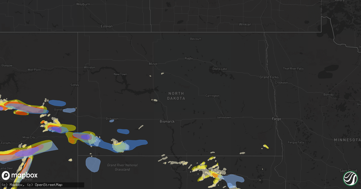
Hail Map in North Dakota on July 3, 2022
Get this storm
July 3 map
$229
one time, instant access
Download today. No call, no setup
Keep the $229
Bought the map and want the full workflow? Apply the entire $229 to a subscription within 7 days. None of it is wasted.
Every map, not just this one
This buys you this map. Subscription and you get every map we run, in the markets you choose from a few cities to whole states to nationwide. Plus real-time alerts the moment a storm fires.
Contact data
Name, contact info, occupancy, even credit band for addresses in the footprint. You go from where it hit to who to call.
Become the source they trust
Unlimited branding weather history reports on demand. You already have the documented answer ready for the property owner, and you are the one who showed up with it.
Property data and RoofTrace estimates
Pull up any address you have got, its value and the exact code rules for that jurisdiction, straight from One Click Code. Then RoofTrace estimates the squares, pitch, and roof value, priced the way you price.
Storm reports in North Dakota
North Dakota
| Date | Description |
|---|---|
| 07/03/20225:27 PM CDT | Nickel to quarter size hail... Smaller at first then a few larger ones. A supercell thunderstorm with a well developed wall cloud tracked through central and eastern de |
| 07/03/20225:41 AM CDT | At 1038 PM MDT, severe thunderstorms were located along a line extending from 11 miles southwest of South Heart to 6 miles northeast of Bowman to Table Mountain, moving east at 40 mph. HAZARD...70 mph wind gusts and nickel size hail. SOURCE...Radar indicated. IMPACT...Expect considerable tree damage. Damage is likely to mobile homes, roofs, and outbuildings. Severe thunderstorms will be near... Scranton around 1050 PM MDT.Other locations in the path of these severe thunderstorms includeMott. |
| 07/03/20223:53 AM CDT | At 852 PM MDT, severe thunderstorms were located along a line extending from 7 miles northeast of Savage to 10 miles west of Carlyle, moving east at 35 mph. HAZARD...70 mph wind gusts. SOURCE...Radar indicated. IMPACT...Expect considerable tree damage. Damage is likely to mobile homes, roofs, and outbuildings. Locations impacted include... Wibaux, Savage, Carlyle, Skaar, Hodges, Saint Phillip, Midway, Burns, Crane and Yates. |
| 07/03/20222:20 AM CDT | Mesonet station 327800 7 ssw sawyer |
| 07/03/20222:01 AM CDT | At 701 PM MDT, severe thunderstorms were located along a line extending from near Vida to 6 miles northeast of Lindsay to 13 miles west of West Glendive, moving northeast at 45 mph. HAZARD...60 mph wind gusts and quarter size hail. SOURCE...Radar indicated. IMPACT...Hail damage to vehicles is expected. Expect wind damage to roofs, siding, and trees. Locations impacted include... Sidney, Glendive, Circle, Terry, Wibaux, Fallon, Richey, Savage, West Glendive, Intake, Bloomfield, Lambert, Carlyle, Lindsay, Enid, Wooley, Crane, Mildred, Midway and Hoyt. |
| 07/03/20221:05 AM CDT | Williams lookout raws observation. |
| 07/03/20221:00 AM CDT | Private weather instrument observation. |
| 07/03/202212:32 AM CDT | Relayed via social media. |
| 07/03/202212:22 AM CDT | Asos station kdik dickinson airport. |
| 07/03/202212:01 AM CDT | Ndawn station 4 w bowman. |
| 07/02/202211:59 PM CDT | At 459 PM CDT, a severe thunderstorm was located near Hamlin, or 29 miles west of Wahpeton, moving east at 5 mph. HAZARD...60 mph wind gusts and quarter size hail. SOURCE...Radar indicated. IMPACT...Hail damage to vehicles is expected. Expect wind damage to roofs, siding, and trees. Locations impacted include... Wyndmere and Barney. |
All States Impacted by Hail Map on July 3, 2022
Cities Impacted by Hail Map on July 3, 2022
- Brewster, WA
- Quincy, WA
- Malaga, WA
- Rock Island, WA
- Philipsburg, MT
- Cohagen, MT
- Orofino, ID
- Mound City, SD
- Ismay, MT
- Regent, ND
- Mott, ND
- New England, ND
- Hettinger, ND
- Fallon, MT
- Glendive, MT
- Terry, MT
- Max, ND
- Douglas, ND
- Wakpala, SD
- McLaughlin, SD
- Pollock, SD
- Herreid, SD
- Colfax, WA
- Ekalaka, MT
- Interior, SD
- Elgin, ND
- Glen Ullin, ND
- Almont, ND
- Plains, MT
- Wyndmere, ND
- Lidgerwood, ND
- Velva, ND
- Wibaux, MT
- Aberdeen, SD
- Westport, SD
- Lindsay, MT
- Bloomfield, MT
- Deer Park, WA
- Nine Mile Falls, WA
- Leola, SD
- Decker, MT
- Spencer, ID
- Lima, MT
- Dubois, ID
- Cameron, MT
- Bowdle, SD
- Darby, MT
- Volborg, MT
- Pray, MT
- Gardiner, MT
- Livingston, MT
- Huntley, MT
- Sheridan, WY
- Birney, MT
- Hardin, MT
- Worden, MT
- Ballantine, MT
- Colstrip, MT
- Pompeys Pillar, MT
- Bighorn, MT
- Otter, MT
- Forsyth, MT
- Thornton, WA
- Oakesdale, WA
- Jordan, MT
- Midland, SD
- Cresbard, SD
- Long Valley, SD
- Belvidere, SD
- Rhame, ND
- Bowman, ND
- Underwood, MN
- Battle Lake, MN
- Washburn, ND
- Selfridge, ND
- Northville, SD
- Sand Springs, MT
- Brockway, MT
- Brusett, MT
- Winnett, MT
- Mosby, MT
- Underwood, ND
- Kadoka, SD
- Amidon, ND
- Webster, SD
- Pomaria, SC
- White River, SD
- Pine Ridge, SD
- Conner, MT
- Sula, MT
- Rosebud, MT
- Eureka, SD
- Java, SD
- Hot Springs, MT
- Lonepine, MT
- Ludlow, SD
- Billings, MT
- Shepherd, MT
- Acton, MT
- Colville, WA
- Long Lake, SD
- Chamberlain, SD
- Hamill, SD
- Gregory, SD
- Graettinger, IA
- Bridgeport, TX
- Wilmington, NC
- Philip, SD
- Wall, SD
- Pukwana, SD
- Model, CO
- Jacksboro, TX
- Bowie, TX
- Ward, CO
- Jamestown, CO
- Windthorst, TX
- Scotland, TX
- Henrietta, TX
- Dodd City, TX
- Windom, TX
- Honey Grove, TX
- Forestburg, TX
- Alvord, TX
- Jerico Springs, MO
- New Underwood, SD
- Bishopville, SC
- Hartsville, SC
- McBee, SC
- Saint Jo, TX
- Muenster, TX
- Chico, TX
- Ryan, OK
- Ringling, OK
- Nocona, TX
- Marietta, OK
- Fort Scott, KS
- Bertrand, NE
- Waldo, KS
- Paradise, KS
- Russell, KS
- Arcadia, NE
- Ipswich, SD
- New Bern, NC
- Cave Springs, AR
- Springdale, AR
- Lowell, AR
- Rogers, AR
- Bentonville, AR
- Early Branch, SC
- Throckmorton, TX
- Seymour, TX
- Willard, MO
- Le Roy, KS
- Roscoe, SD
- Hosmer, SD
- Yemassee, SC
- Colony, KS
- Tolstoy, SD
- Ree Heights, SD
- Highmore, SD
- Miller, SD
- Campbell, NE
- Bladen, NE
- Murdo, SD
- Clarkton, NC
- Bladenboro, NC
- Norris, SD
- Martin, SD
- Wichita Falls, TX
- Wolsey, SD
- Big Timber, MT
- Ryegate, MT
- Melville, MT
- Rapelje, MT
- Reed Point, MT
- Draper, SD
- Porcupine, SD
- Wounded Knee, SD
- Wanblee, SD
- Batesland, SD
- Allen, SD
- Kyle, SD
- Wasta, SD
- Scenic, SD
- Owanka, SD
- Goodland, KS
- Pilot Point, TX
- Tioga, TX
- Alpena, SD
- Woonsocket, SD
- Neodesha, KS
- Altoona, KS
- Buffalo, KS
- Benedict, KS
- Fredonia, KS
- Glenvil, NE
- Hastings, NE
- Inland, NE
- Ayr, NE
- Curtis, NE
- Moorefield, NE
- Okaton, SD
- Cleo Springs, OK
- Nevada, MO
- Arcadia, KS
- Elizabethtown, NC
- Greensboro, GA
- Union Point, GA
- Bryson, TX
- Lindsay, NE
- Bellevue, TX
- Gainesville, TX
- Tuthill, SD
- Mcdonough, GA
- Concord, GA
- Molena, GA
- Huron, SD
- Oacoma, SD
- Yates Center, KS
- Carthage, SD
- Artesian, SD
- Sturgis, SD
- Fort Meade, SD
- Kennebec, SD
- Fort Myers, FL
- Lakemont, GA
- Tiger, GA
- Troy, NC
- Lewellen, NE
- Chappell, NE
- Oshkosh, NE
- Big Springs, NE
- Graniteville, SC
- Auburntown, TN
- Liberty, TN
- Alexandria, TN
- Ruby, SC
- Chesterfield, SC
- Nashville, TN
- Randlett, OK
- Delco, NC
- Westphalia, KS
- Burlington, KS
- Waverly, KS
- Fergus Falls, MN
- Dalton, MN
- Loving, TX
- Neosho Falls, KS
- Electra, TX
- Broadview, MT
- Rapid City, SD
- Piedmont, SD
- Farnam, NE
- Stockville, NE
- Maywood, NE
- Wellfleet, NE
- Hayes Center, NE
- Ridgeway, SC
- Ottawa, KS
- Dalzell, SC
- Rembert, SC
- Graysville, TN
- Presho, SD
- Vivian, SD
- Richmond, KS
- Garnett, KS
- Durant, OK
- Faulkton, SD
- Leland, NC
- Kimball, SD
- White Lake, SD
- Wessington Springs, SD
- Scottsbluff, NE
- Gann Valley, SD
- Plankinton, SD
- Cove City, NC
- Pomona, KS
- Watkinsville, GA
- Bishop, GA
- Millen, GA
- Dulce, NM
- Magnolia, NC
- Warsaw, NC
- Hookerton, NC
- Grifton, NC
- Minatare, NE
- Holliday, TX
- Elizabeth City, NC
- Roseland, NE
- Eden, SD
- Opelika, AL
- Redfield, SD
- Brentford, SD
- Ashton, SD
- Conde, SD
- Doland, SD
- Turton, SD
- Frankfort, SD
- Mellette, SD
- Sanger, TX
- Monroe, NC
- Pageland, SC
- Molt, MT
- Dalton, NE
- Lisco, NE
- Wood, SD
- Lumberton, NC
- Oak Ridge, TN
- Valley View, TX
- Sherman, TX
- Missouri Valley, IA
- Logan, IA
- Kinston, NC
- Manderson, SD
- Piqua, KS
- Evergreen, NC
- Chadbourn, NC
- Upland, NE
- Minden, NE
- Franklin, NE
- Bloomington, NE
- Hildreth, NE
- Harvard, NE
- Athens, GA
- South Mills, NC
- Virgil, SD
- Wessington, SD
- Oakes, ND
- Cogswell, ND
- Reliance, SD
- Lower Brule, SD
- Fayetteville, NC
- White Oak, NC
- Hiawassee, GA
- Ellsworth, NE
- Bingham, NE
- Riverton, NE
- Galivants Ferry, SC
- Marion, SC
- Gresham, SC
- Blossom, TX
- Jefferson, SC
- Ringgold, TX
- Millry, AL
- Saint Lawrence, SD
- Loco, OK
- Deadwood, SD
- Clarks Hill, SC
- Caputa, SD
- Fort Pierre, SD
- Quinn, SD
- Fedora, SD
- Iroquois, SD
- Cavour, SD
- Albion, NE
- Comstock, NE
- Westerville, NE
- Ansley, NE
- Rosston, TX
- Blair, SC
- Paradise, TX
- Rutledge, GA
- Madison, GA
- Lamar, SC
- Lance Creek, WY
- Kershaw, SC
- Ringgold, GA
- Mitchell, NE
- Edgemont, SD
- Columbus, KS
- Scammon, KS
- Fruitdale, AL
- Vinegar Bend, AL
- Monroe, GA
- Good Hope, GA
- Milo, MO
- Conyers, GA
- Onaka, SD
- Hooper, NE
- Mullins, SC
- Wrightsville Beach, NC
- Ashley, ND
- Cayuga, ND
- Rockham, SD
- Dewy Rose, GA
- Saint Pauls, NC
- Poolville, TX
- Fayetteville, AR
- Naponee, NE
- Bogart, GA
- Statham, GA
- Omaha, NE
- Addy, WA
- Strandquist, MN
- Newfolden, MN
- New Leipzig, ND
- Pendleton, OR
- Estelline, SD
- Henning, MN
- Brule, NE
- Plevna, MT
- Baker, MT
- Willard, MT
- Milesville, SD
- Groton, SD
- Warner, SD
- Andover, SD
- Mansfield, SD
- Stratford, SD
- Bath, SD
- Ferney, SD
- Reva, SD
- Buffalo, SD
- Raymond, SD
- Grand Island, NE
- Polson, MT
- Custer, MT
- Marmarth, ND
- Mullen, NE
- Sutherland, NE
- Arthur, NE
- Tryon, NE
- Lemoyne, NE
- Doniphan, NE
- Chapman, NE
- Phillips, NE
- Alda, NE
- Black Hawk, SD
- Enning, SD
- Howes, SD
- Carson, ND
- Scranton, ND
- Reeder, ND
- Dickinson, ND


