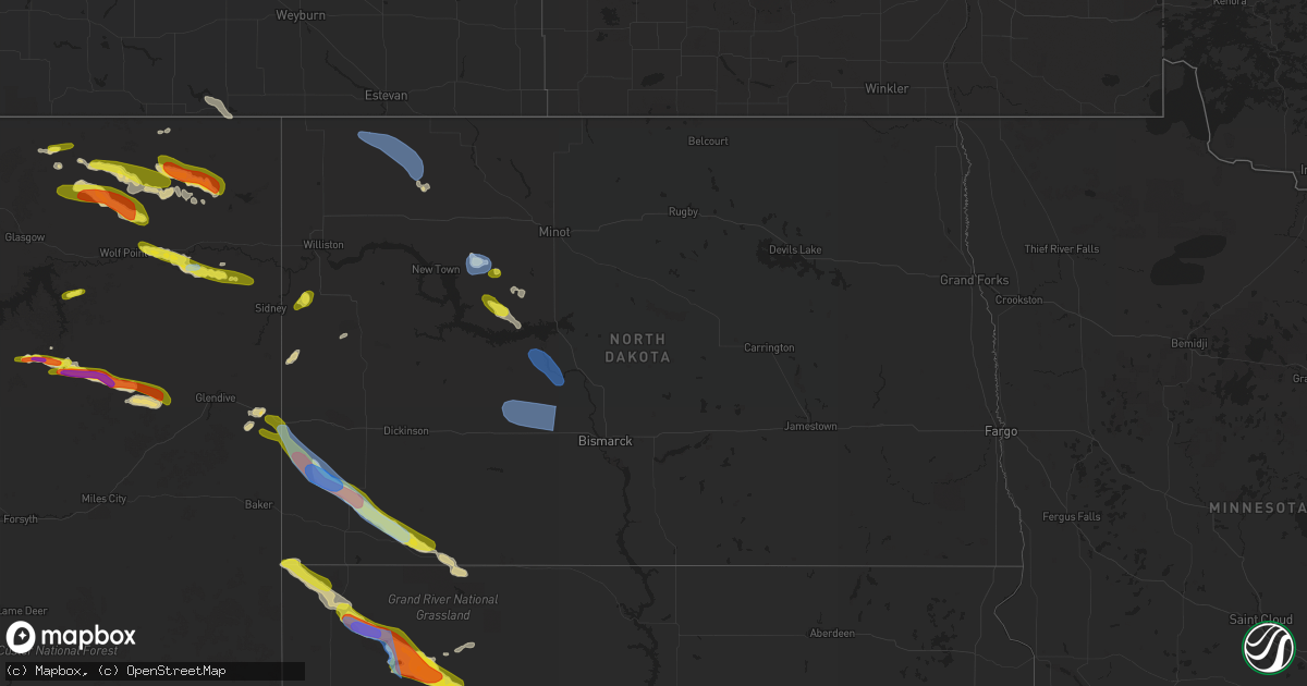
Hail Map in North Dakota on July 2, 2022
Get this storm
July 2 map
$229
one time, instant access
Download today. No call, no setup
Keep the $229
Bought the map and want the full workflow? Apply the entire $229 to a subscription within 7 days. None of it is wasted.
Every map, not just this one
This buys you this map. Subscription and you get every map we run, in the markets you choose from a few cities to whole states to nationwide. Plus real-time alerts the moment a storm fires.
Contact data
Name, contact info, occupancy, even credit band for addresses in the footprint. You go from where it hit to who to call.
Become the source they trust
Unlimited branding weather history reports on demand. You already have the documented answer ready for the property owner, and you are the one who showed up with it.
Property data and RoofTrace estimates
Pull up any address you have got, its value and the exact code rules for that jurisdiction, straight from One Click Code. Then RoofTrace estimates the squares, pitch, and roof value, priced the way you price.
Storm reports in North Dakota
North Dakota
| Date | Description |
|---|---|
| 07/02/20226:25 PM CDT | A local report indicates 72 MPH wind near 9 S NOONAN |
| 07/02/20226:24 PM CDT | Ndawn station ray 4n. 10 meter measured wind gust. |
| 07/02/20226:15 PM CDT | Small broken branches. |
| 07/02/20225:41 AM CDT | At 1040 PM CDT, severe thunderstorms were located along a line extending from 5 miles west of Wilton to 6 miles southwest of Lake Harmon to 6 miles west of Fish Creek Dam, moving east at 35 mph. HAZARD...60 mph wind gusts and nickel size hail. SOURCE...Radar indicated. IMPACT...Expect damage to roofs, siding, and trees. Severe thunderstorms will be near... Mandan, Wilton and Lake Harmon around 1050 PM CDT. Bismarck and Regan around 1110 PM CDT. Lincoln and Mcdowell Dam Recreation Area around 1115 PM CDT. St. Anthony around 1120 PM CDT. Menoken around 1125 PM CDT.Other locations impacted by these severe thunderstorms include DoubleDitch Indian Village, Sweet Briar Lake, Price, Mckenzie, Baldwin,Crown Butte Lake, Sanger, Fort Abraham Lincoln State Park, UniversityOf Mary and Arena. |
| 07/02/20225:09 AM CDT | At 1008 PM CDT, severe thunderstorms were located along a line extending from near Underwood to 8 miles northeast of Center to 9 miles northeast of Glen Ullin, moving southeast at 35 mph. HAZARD...60 mph wind gusts and quarter size hail. SOURCE...Radar indicated. IMPACT...Hail damage to vehicles is expected. Expect wind damage to roofs, siding, and trees. Severe thunderstorms will be near... Cross Ranch State Park around 1025 PM CDT. New Salem around 1030 PM CDT. Wilton around 1045 PM CDT. Fish Creek Dam around 1050 PM CDT.Other locations impacted by these severe thunderstorms include DoubleDitch Indian Village, Sweet Briar Lake, Price, New Johns Lake,Falkirk, Baldwin, Crown Butte Lake, Sanger, Hensler and Fort Clark. |
| 07/02/20224:08 AM CDT | At 907 PM CDT, severe thunderstorms were located along a line extending from near Douglas to 8 miles northwest of Hazen Bay Recreation Area to near Golden Valley, moving southeast at 30 mph. HAZARD...60 mph wind gusts and nickel size hail. SOURCE...Radar indicated. IMPACT...Expect damage to roofs, siding, and trees. Severe thunderstorms will be near... Hazen Bay Recreation Area around 920 PM CDT. Max around 925 PM CDT. Beulah, Garrison, Lake Sakakawea State Park and Fort Stevenson State Park around 930 PM CDT. Pick City around 935 PM CDT. Riverdale around 940 PM CDT. Stanton and Coleharbor around 950 PM CDT. Underwood around 1000 PM CDT. Hannover around 1005 PM CDT.Other locations impacted by these severe thunderstorms includeHensler, Dakota Waters Recreation Area, Emmet, Fort Clark, WhiteShield and Falkirk. |
| 07/02/20223:15 AM CDT | At 814 PM CDT/714 PM MDT/, severe thunderstorms were located along a line extending from near Plaza to 8 miles southwest of Parshall to 8 miles north of Mckenzie Bay Recreation Area, moving southeast at 35 mph. HAZARD...60 mph wind gusts and nickel size hail. SOURCE...Radar indicated. IMPACT...Expect damage to roofs, siding, and trees. Severe thunderstorms will be near... Plaza around 820 PM CDT. Mckenzie Bay Recreation Area around 825 PM CDT. Makoti around 830 PM CDT.Other locations in the path of these severe thunderstorms includeRyder, Roseglen, Indian Hills Recreation Area, Douglas, Beulah BayRecreation Area and Hazen Bay Recreation Area. |
| 07/02/20222:58 AM CDT | At 757 PM MDT, a severe thunderstorm was located 10 miles southeast of Amidon, moving southeast at 35 mph. HAZARD...Golf ball size hail and 70 mph wind gusts. SOURCE...Radar indicated. IMPACT...People and animals outdoors will be injured. Expect hail damage to roofs, siding, windows, and vehicles. Expect considerable tree damage. Wind damage is also likely to mobile homes, roofs, and outbuildings. Locations impacted include... Reeder. |
| 07/02/20222:19 AM CDT | At 717 PM MDT, a severe thunderstorm was located 10 miles west of Amidon, moving southeast at 45 mph. HAZARD...Golf ball size hail and 60 mph wind gusts. SOURCE...Radar indicated. IMPACT...People and animals outdoors will be injured. Expect hail damage to roofs, siding, windows, and vehicles. Expect wind damage to roofs, siding, and trees. This severe thunderstorm will be near... Amidon around 730 PM MDT. |
| 07/02/20222:16 AM CDT | At 716 PM MDT, a severe thunderstorm was located near Ladner, or 20 miles northwest of Buffalo, moving southeast at 20 mph. HAZARD...60 mph wind gusts and quarter size hail. SOURCE...Radar indicated. IMPACT...Hail damage to vehicles is expected. Expect wind damage to roofs, siding, and trees. This severe thunderstorm will be near... Ladner and Table Mountain around 725 PM MDT.Other locations in the path of this severe thunderstorm include SouthCave Hills. |
| 07/02/20221:49 AM CDT | At 649 PM MDT, a severe thunderstorm was located near Golva, or 14 miles south of Beach, moving southeast at 25 mph. HAZARD...60 mph wind gusts and quarter size hail. SOURCE...Radar indicated. IMPACT...Hail damage to vehicles is expected. Expect wind damage to roofs, siding, and trees. This severe thunderstorm will remain over mainly rural areas of southern Golden Valley, southwestern Billings and northwestern Slope Counties, including the following locations... Alpha and Three V Crossing. |
| 07/02/20221:45 AM CDT | At 644 PM CDT, severe thunderstorms were located along a line extending from Lignite to 13 miles northeast of Battleview to 4 miles southeast of Powers Lake, moving southeast at 35 mph. HAZARD...70 mph wind gusts. SOURCE...Public. IMPACT...Expect considerable tree damage. Damage is likely to mobile homes, roofs, and outbuildings. Severe thunderstorms will be near... Flaxton and Lostwood around 700 PM CDT.Other locations in the path of these severe thunderstorms includeBowbells, Palermo, Kenmare and Blaisdell. |
| 07/02/20221:34 AM CDT | At 634 PM CDT, severe thunderstorms were located along a line extending from near Battleview to 5 miles east of Epping to near Williston, moving east at 35 mph. HAZARD...60 mph wind gusts and penny size hail. SOURCE...Radar indicated. IMPACT...Expect damage to roofs, siding, and trees. Severe thunderstorms will be near... Powers Lake and Battleview around 640 PM CDT.Other locations in the path of these severe thunderstorms includeLostwood, Stanley and Palermo. |
| 07/02/20221:19 AM CDT | At 619 PM MDT, a severe thunderstorm was located over Beach, moving east at 15 mph. HAZARD...60 mph wind gusts and quarter size hail. SOURCE...Radar indicated. IMPACT...Hail damage to vehicles is expected. Expect wind damage to roofs, siding, and trees. This severe thunderstorm will be near... Beach around 625 PM MDT.Other locations in the path of this severe thunderstorm includeSentinel Butte. |
| 07/02/20221:00 AM CDT | At 600 PM CDT, a severe thunderstorm was located near Noonan, or 13 miles southeast of Crosby, moving east at 35 mph. HAZARD...60 mph wind gusts and nickel size hail. SOURCE...Radar indicated. IMPACT...Expect damage to roofs, siding, and trees. This severe thunderstorm will remain over mainly rural areas of Burke and northeastern Divide Counties, including the following locations... Larson and Northgate. |
| 07/02/202212:12 AM CDT | At 511 PM MDT, a severe thunderstorm was located 16 miles north of Lambert, or 16 miles south of Culbertson, moving east at 30 mph. HAZARD...60 mph wind gusts and quarter size hail. SOURCE...Radar indicated. IMPACT...Hail damage to vehicles is expected. Expect wind damage to roofs, siding, and trees. Locations impacted include... Sidney, Fairview, East Fairview and Wooley. |
| 07/01/202210:23 PM CDT | Measured wind gust from personal weather station. |
| 07/01/20229:51 PM CDT | A local report indicates 60 MPH wind near RIVERDALE |
| 07/01/20229:39 PM CDT | Measured wind gust from personal weather station. |
| 07/01/20229:37 PM CDT | Measured on car roof anemometer. Report from off duty nws employee. Some blowing dust observed as well. |
| 07/01/20229:30 PM CDT | Relayed through social media. Wind speed estimated... With hail a little smaller than a marble. |
| 07/01/20229:25 PM CDT | Pea sized hail. |
| 07/01/20229:09 PM CDT | Mafb personnel. |
| 07/01/20228:40 PM CDT | Penny to nickel size hail. Reported by minot air force base personnel. |
| 07/01/20228:38 PM CDT | Corrects time of previous lsr. |
| 07/01/20228:38 PM CDT | A local report indicates 70 MPH wind near PLAZA |
| 07/01/20228:28 PM CDT | Sand creek raws site. Time estimated from radar. |
| 07/01/20228:07 PM CDT | Us air force weather station 4.3 wnw parshall. |
| 07/01/20227:47 PM CDT | Ndawn station beach 9s. 10 meter measured wind gust. |
| 07/01/20227:30 PM CDT | Dime sized hail. |
All States Impacted by Hail Map on July 2, 2022
Cities Impacted by Hail Map on July 2, 2022
- Ellsworth, ME
- Hancock, ME
- Wasta, SD
- Howes, SD
- Frazer, MT
- Peerless, MT
- Larslan, MT
- Wolf Point, MT
- Whitetail, MT
- Sturgis, SD
- Powers Lake, ND
- Stanley, ND
- Fort Pierre, SD
- Brockton, MT
- Decker, MT
- Sheridan, WY
- Waco, KY
- Richmond, KY
- Del Rio, TX
- Cartwright, ND
- Woodburn, KY
- Franklin, KY
- Mulvane, KS
- Clyde, NC
- Wall, SD
- Milesville, SD
- Midland, SD
- Marion, KY
- Fairview, OK
- Hepler, KS
- Uniontown, KS
- Redfield, KS
- Rocksprings, TX
- Granby, MA
- Ludlow, MA
- Bondsville, MA
- West Warren, MA
- Belchertown, MA
- Palmer, MA
- Thorndike, MA
- Ware, MA
- Mcminnville, TN
- Morrison, TN
- Augusta, KS
- Andover, KS
- Rhame, ND
- Ludlow, SD
- Prairie City, SD
- Bison, SD
- Meadow, SD
- Buffalo, SD
- Faith, SD
- Camp Crook, SD
- Mud Butte, SD
- Reva, SD
- Richland, MT
- Huron, SD
- Virgil, SD
- Wolsey, SD
- Alpena, SD
- Glen Rose, TX
- Bowman, ND
- Amidon, ND
- Sentinel Butte, ND
- Reeder, ND
- Hettinger, ND
- Scranton, ND
- Ryder, ND
- Reserve, MT
- Flaxville, MT
- Scobey, MT
- Roundhill, KY
- Brownsville, KY
- Morgantown, KY
- Caneyville, KY
- Cedar Vale, KS
- Adams, OR
- Norwich, KS
- Milton, KS
- Beattyville, KY
- Jackson, KY
- Tyndall, SD
- Avon, SD
- Middletown, MD
- Jefferson, MD
- Heppner, OR
- Honaker, VA
- Spurlockville, WV
- Uvalde, TX
- Canadian, TX
- Chester, OK
- Enid, OK
- Waukomis, OK
- Elkton, MD
- Orrtanna, PA
- Makoti, ND
- El Dorado, KS
- Welch, WV
- Herndon, WV
- Northfork, WV
- Clayton, NM
- Garrison, ND
- Roseglen, ND
- Wibaux, MT
- Broadview, MT
- Ryegate, MT
- Rapelje, MT
- Lynchburg, VA
- Rock Island, TN
- Roanoke, VA
- Burkesville, KY
- Lambert, MT
- Poplar, MT
- Fairview, MT
- Philip, SD
- Spivey, KS
- Harper, KS
- Williamson, WV
- Delbarton, WV
- Lancaster, KY
- Knippa, TX
- Stonefort, IL
- Creal Springs, IL
- New Burnside, IL
- Ozark, IL
- Concord, VA
- Madison Heights, VA
- Spout Spring, VA
- Gaithersburg, MD
- Fredericktown, MO
- Farmington, MO
- Asbury Park, NJ
- Eatontown, NJ
- Deal, NJ
- Howell, NJ
- West Long Branch, NJ
- Freehold, NJ
- Farmingdale, NJ
- Long Branch, NJ
- Oakhurst, NJ
- Neptune, NJ
- Colts Neck, NJ
- Irvine, KY
- Cohagen, MT
- Prairie City, OR
- Pilot Rock, OR
- Pendleton, OR
- Long Creek, OR
- Monument, OR
- La Grande, OR
- Summerville, OR
- Statesville, NC
- Opheim, MT
- Stoddard, WI
- Brownsville, MN
- Chaseburg, WI
- Hokah, MN
- La Crosse, WI
- Brackettville, TX
- New Underwood, SD
- Enning, SD
- Grenola, KS
- Cambridge, KS
- Latham, KS
- Jordan, MT
- Plaza, ND
- Parshall, ND
- White River, SD
- Murdo, SD
- Lemmon, SD
- Springfield, SD
- Vega, TX
- Clothier, WV
- Yolyn, WV
- Turtle Creek, WV
- Jeffrey, WV
- Hewett, WV
- Danville, WV
- Chapmanville, WV
- Alkol, WV
- Rapid City, SD
- Kadoka, SD
- De Smet, SD
- Erwin, SD
- Dalhart, TX
- Dryden, TX
- Manchester, KY
- Balko, OK
- Bend, OR
- Grassy Butte, ND
- Elgin, OR
- Spray, OR
- Fossil, OR
- Carrizo Springs, TX
- Asherton, TX
- Jetson, KY
- Pecks Mill, WV
- Lake, WV
- Martinsburg, WV
- Shepherdstown, WV
- Providence, KY
- Viola, KS
- Goddard, KS
- Clearwater, KS
- Fredonia, KY
- Cleburne, TX
- Joshua, TX
- Alvarado, TX
- Keene, TX
- Alexander, ND
- Sugar City, CO
- Rose Hill, KS
- Campton, KY
- Vancleve, KY
- Dawson Springs, KY
- Madisonville, KY
- Hazel Green, KY
- Mize, KY
- Cannel City, KY
- West Liberty, KY
- Salyersville, KY
- Boss, MO
- Shelby, MT
- Circle, MT
- Fort Peck, MT
- Haines, OR
- Ashland, OR
- Eagle Point, OR
- Newcastle, WY
- Winston Salem, NC
- Long Valley, SD
- Paint Rock, TX
- Sturgis, KY
- Perryton, TX
- Cut Bank, MT
- Belvidere, SD
- Gilchrist, OR
- Axton, VA
- Cheyenne, OK
- Scotland, SD
- Tripp, SD
- Okaton, SD
- Raymond, MT
- Driggs, ID
- Terry, MT
- Lindsay, MT
- Glendive, MT
- Highlands, NJ
- Fountain, CO
- Bevinsville, KY
- Topmost, KY
- Weeksbury, KY
- Kite, KY
- Beaver, KY
- Hi Hat, KY
- McDowell, KY
- Bypro, KY
- Wheelwright, KY
- Melvin, KY
- Wrightsville, PA
- East Petersburg, PA
- Rising Sun, MD
- Drumore, PA
- Landisville, PA
- Conestoga, PA
- York, PA
- Kirkwood, PA
- Red Lion, PA
- Mountville, PA
- Nottingham, PA
- Landenberg, PA
- North East, MD
- Oxford, PA
- Columbia, PA
- Delta, PA
- Holtwood, PA
- Lincoln University, PA
- Felton, PA
- New Providence, PA
- Airville, PA
- Peach Bottom, PA
- Mount Joy, PA
- Windsor, PA
- Pequea, PA
- Washington Boro, PA
- Quarryville, PA
- Marietta, PA
- Manheim, PA
- Conowingo, MD
- Brogue, PA
- Millersville, PA
- Lancaster, PA
- Lititz, PA
- Rockville, MD
- Great Falls, VA
- Potomac, MD
- Corbin, KY
- Sonora, TX
- Hagerstown, MD
- Ozona, TX
- Sabillasville, MD
- Gettysburg, PA
- Emmitsburg, MD
- Thurmont, MD
- Smithsburg, MD
- Cascade, MD
- Littlestown, PA
- Fairfield, PA
- Somerset, TX
- Poteet, TX
- Texhoma, OK
- Stratford, TX
- Oxford, GA
- Covington, GA
- Brockway, MT
- Wellington, KS
- Belle Plaine, KS
- Booneville, KY
- Talent, OR
- Medford, OR
- Amarillo, TX
- Seiling, OK
- Oakwood, OK
- Canton, OK
- Drakesboro, KY
- Rochester, KY
- Beaver Dam, KY
- Belton, KY
- Eureka, KS
- Nottingham, MD
- Glen Arm, MD
- Parkville, MD
- Perry Hall, MD
- Pleasanton, TX
- Salem, MO
- Sabinal, TX
- Concan, TX
- Daniel, WY
- Frederick, MD
- Browder, KY
- Beechmont, KY
- Beech Creek, KY
- Spearman, TX
- La Pryor, TX
- Kiowa, KS
- Alva, OK
- Burlington, OK
- Meally, KY
- Wittensville, KY
- Paintsville, KY
- Williamsport, KY
- Staffordsville, KY
- Van Lear, KY
- Boons Camp, KY
- Sitka, KY
- Thelma, KY
- New Castle, DE
- Bear, DE
- Newark, DE
- Pampa, TX
- Comstock, TX
- Weston, CO
- Arkansas City, KS
- Crystal City, TX
- Kingston, MA
- Plymouth, MA
- Plympton, MA
- Welch, OK
- Hooker, OK
- Springfield, CO
- Boise City, OK
- Felt, OK
- West Grove, PA
- Boonsboro, MD
- Fairplay, MD
- Sharpsburg, MD
- Williamsport, MD
- Mayfield, KS
- Clay, WV
- Summersville, WV
- Presho, SD
- Warren, MA
- Brimfield, MA
- Onida, SD
- La Pine, OR
- Coon Valley, WI
- Caledonia, MN
- Hagerhill, KY
- Debord, KY
- Flatgap, KY
- Pueblo, CO
- Kaylor, SD
- Niobrara, NE
- Meacham, OR
- Jacksonville, OR
- Phoenix, OR
- Willow Street, PA
- Oceanport, NJ
- Fort Monmouth, NJ
- Millville, NJ
- Edgemont, SD
- Hot Springs, SD
- Hill City, SD
- Oral, SD
- Pine Ridge, SD
- Smithwick, SD
- Panhandle, TX
- Idaho Falls, ID
- Dubois, ID
- Monteview, ID
- Saint Anthony, ID
- Terreton, ID
- Hamer, ID
- Blackfoot, ID
- Spencer, ID
- Moore, ID
- Arco, ID
- Plentywood, MT
- Redstone, MT
- Culbertson, MT
- Sidney, MT
- Kevin, MT
- Columbus, ND
- Noonan, ND
- Lignite, ND
- Crosby, ND
- Golva, ND
- Beach, ND
- New England, ND
- Center, ND
- Stanton, ND
- Washburn, ND
- Underwood, ND
- Hazen, ND
- Bismarck, ND
- Mandan, ND
- New Salem, ND
- Glen Ullin, ND
- Beulah, ND


