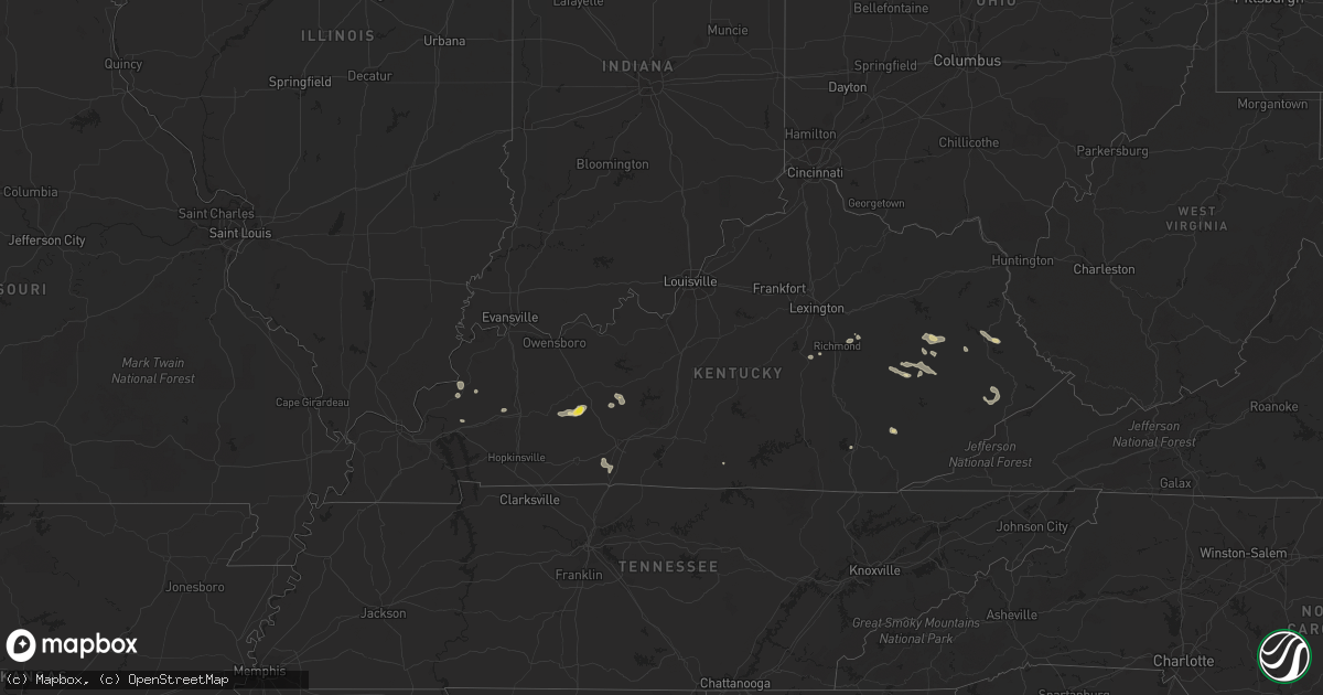
Hail Map in Kentucky on July 2, 2022
Get this storm
July 2 map
$229
one time, instant access
Download today. No call, no setup
Keep the $229
Bought the map and want the full workflow? Apply the entire $229 to a subscription within 7 days. None of it is wasted.
Every map, not just this one
This buys you this map. Subscription and you get every map we run, in the markets you choose from a few cities to whole states to nationwide. Plus real-time alerts the moment a storm fires.
Contact data
Name, contact info, occupancy, even credit band for addresses in the footprint. You go from where it hit to who to call.
Become the source they trust
Unlimited branding weather history reports on demand. You already have the documented answer ready for the property owner, and you are the one who showed up with it.
Property data and RoofTrace estimates
Pull up any address you have got, its value and the exact code rules for that jurisdiction, straight from One Click Code. Then RoofTrace estimates the squares, pitch, and roof value, priced the way you price.
Storm reports in Kentucky
Kentucky
| Date | Description |
|---|---|
| 07/02/20224:38 PM CDT | A tree was blown onto rochester road. |
| 07/02/20223:57 PM CDT | Large tree limbs down in the road on washington avenue. Time estimated from radar. |
| 07/02/20223:27 PM CDT | Estimated 40 to 60 mph near deaconess hospital. Heavy rain also reported. |
| 07/02/20223:25 PM CDT | One tree and several large limbs blown down across state route 365... About 4 miles from u.s. Highway 60 in the northeast part of crittenden county. |
| 07/02/20223:10 PM CDT | Estimated 60+ mph winds near clay... Ky. |
| 07/01/202211:49 PM CDT | At 449 PM EDT, a severe thunderstorm was located over Guerrant, or 8 miles southwest of Jackson, moving east at 30 mph. HAZARD...60 mph wind gusts and penny size hail. SOURCE...Radar indicated. IMPACT...Expect damage to roofs, siding, and trees. This severe thunderstorm will be near... Sebastian's Branch around 455 PM EDT. Curt around 500 PM EDT. Howard Creek around 505 PM EDT.Other locations in the path of this severe thunderstorm include LostCreek, Watts and Hardshell. |
| 07/01/202211:30 PM CDT | At 429 PM CDT, a severe thunderstorm was located 8 miles west of Morgantown, moving northeast at 10 mph. HAZARD...60 mph wind gusts and quarter size hail. SOURCE...Radar indicated. IMPACT...Hail damage to vehicles is expected. Expect wind damage to roofs, siding, and trees. This severe thunderstorm will remain over mainly rural areas of northwestern Butler County, including the following locations... Mining City, Logansport and Provo. |
| 07/01/202210:35 PM CDT | At 335 PM EDT, a severe thunderstorm was located over Melvin, or 12 miles southwest of Pikeville, moving northeast at 20 mph. HAZARD...60 mph wind gusts and quarter size hail. SOURCE...Radar indicated. IMPACT...Hail damage to vehicles is expected. Expect wind damage to roofs, siding, and trees. This severe thunderstorm will be near... Beaver around 345 PM EDT. Craynor around 350 PM EDT. Galveston around 355 PM EDT.Other locations in the path of this severe thunderstorm includeOsborn. |
| 07/01/202210:27 PM CDT | At 327 PM CDT, a severe thunderstorm was located over Earlington, or near Madisonville, moving east at 20 mph. HAZARD...60 mph wind gusts and nickel size hail. SOURCE...Radar indicated. IMPACT...Expect damage to roofs, siding, and trees. This severe thunderstorm will be near... Earlington around 330 PM CDT. Madisonville and Mortons Gap around 335 PM CDT.This includes the following highways... Interstate 69 in Kentucky between Mile Markers 95 and 122. Western Kentucky Parkway between Mile Markers 39 and 43. Pennyrile Parkway between Mile Markers 32 and 34. |
| 07/01/202210:02 PM CDT | At 301 PM CDT, a severe thunderstorm was located near Clay, or 7 miles west of Providence, moving northeast at 10 mph. HAZARD...60 mph wind gusts and penny size hail. SOURCE...Radar indicated. IMPACT...Expect damage to roofs, siding, and trees. This severe thunderstorm will be near... Providence around 310 PM CDT. Clay around 320 PM CDT. |
All States Impacted by Hail Map on July 2, 2022
Cities Impacted by Hail Map on July 2, 2022
- Ellsworth, ME
- Hancock, ME
- Wasta, SD
- Howes, SD
- Frazer, MT
- Peerless, MT
- Larslan, MT
- Wolf Point, MT
- Whitetail, MT
- Sturgis, SD
- Powers Lake, ND
- Stanley, ND
- Fort Pierre, SD
- Brockton, MT
- Decker, MT
- Sheridan, WY
- Waco, KY
- Richmond, KY
- Del Rio, TX
- Cartwright, ND
- Woodburn, KY
- Franklin, KY
- Mulvane, KS
- Clyde, NC
- Wall, SD
- Milesville, SD
- Midland, SD
- Marion, KY
- Fairview, OK
- Hepler, KS
- Uniontown, KS
- Redfield, KS
- Rocksprings, TX
- Granby, MA
- Ludlow, MA
- Bondsville, MA
- West Warren, MA
- Belchertown, MA
- Palmer, MA
- Thorndike, MA
- Ware, MA
- Mcminnville, TN
- Morrison, TN
- Augusta, KS
- Andover, KS
- Rhame, ND
- Ludlow, SD
- Prairie City, SD
- Bison, SD
- Meadow, SD
- Buffalo, SD
- Faith, SD
- Camp Crook, SD
- Mud Butte, SD
- Reva, SD
- Richland, MT
- Huron, SD
- Virgil, SD
- Wolsey, SD
- Alpena, SD
- Glen Rose, TX
- Bowman, ND
- Amidon, ND
- Sentinel Butte, ND
- Reeder, ND
- Hettinger, ND
- Scranton, ND
- Ryder, ND
- Reserve, MT
- Flaxville, MT
- Scobey, MT
- Roundhill, KY
- Brownsville, KY
- Morgantown, KY
- Caneyville, KY
- Cedar Vale, KS
- Adams, OR
- Norwich, KS
- Milton, KS
- Beattyville, KY
- Jackson, KY
- Tyndall, SD
- Avon, SD
- Middletown, MD
- Jefferson, MD
- Heppner, OR
- Honaker, VA
- Spurlockville, WV
- Uvalde, TX
- Canadian, TX
- Chester, OK
- Enid, OK
- Waukomis, OK
- Elkton, MD
- Orrtanna, PA
- Makoti, ND
- El Dorado, KS
- Welch, WV
- Herndon, WV
- Northfork, WV
- Clayton, NM
- Garrison, ND
- Roseglen, ND
- Wibaux, MT
- Broadview, MT
- Ryegate, MT
- Rapelje, MT
- Lynchburg, VA
- Rock Island, TN
- Roanoke, VA
- Burkesville, KY
- Lambert, MT
- Poplar, MT
- Fairview, MT
- Philip, SD
- Spivey, KS
- Harper, KS
- Williamson, WV
- Delbarton, WV
- Lancaster, KY
- Knippa, TX
- Stonefort, IL
- Creal Springs, IL
- New Burnside, IL
- Ozark, IL
- Concord, VA
- Madison Heights, VA
- Spout Spring, VA
- Gaithersburg, MD
- Fredericktown, MO
- Farmington, MO
- Asbury Park, NJ
- Eatontown, NJ
- Deal, NJ
- Howell, NJ
- West Long Branch, NJ
- Freehold, NJ
- Farmingdale, NJ
- Long Branch, NJ
- Oakhurst, NJ
- Neptune, NJ
- Colts Neck, NJ
- Irvine, KY
- Cohagen, MT
- Prairie City, OR
- Pilot Rock, OR
- Pendleton, OR
- Long Creek, OR
- Monument, OR
- La Grande, OR
- Summerville, OR
- Statesville, NC
- Opheim, MT
- Stoddard, WI
- Brownsville, MN
- Chaseburg, WI
- Hokah, MN
- La Crosse, WI
- Brackettville, TX
- New Underwood, SD
- Enning, SD
- Grenola, KS
- Cambridge, KS
- Latham, KS
- Jordan, MT
- Plaza, ND
- Parshall, ND
- White River, SD
- Murdo, SD
- Lemmon, SD
- Springfield, SD
- Vega, TX
- Clothier, WV
- Yolyn, WV
- Turtle Creek, WV
- Jeffrey, WV
- Hewett, WV
- Danville, WV
- Chapmanville, WV
- Alkol, WV
- Rapid City, SD
- Kadoka, SD
- De Smet, SD
- Erwin, SD
- Dalhart, TX
- Dryden, TX
- Manchester, KY
- Balko, OK
- Bend, OR
- Grassy Butte, ND
- Elgin, OR
- Spray, OR
- Fossil, OR
- Carrizo Springs, TX
- Asherton, TX
- Jetson, KY
- Pecks Mill, WV
- Lake, WV
- Martinsburg, WV
- Shepherdstown, WV
- Providence, KY
- Viola, KS
- Goddard, KS
- Clearwater, KS
- Fredonia, KY
- Cleburne, TX
- Joshua, TX
- Alvarado, TX
- Keene, TX
- Alexander, ND
- Sugar City, CO
- Rose Hill, KS
- Campton, KY
- Vancleve, KY
- Dawson Springs, KY
- Madisonville, KY
- Hazel Green, KY
- Mize, KY
- Cannel City, KY
- West Liberty, KY
- Salyersville, KY
- Boss, MO
- Shelby, MT
- Circle, MT
- Fort Peck, MT
- Haines, OR
- Ashland, OR
- Eagle Point, OR
- Newcastle, WY
- Winston Salem, NC
- Long Valley, SD
- Paint Rock, TX
- Sturgis, KY
- Perryton, TX
- Cut Bank, MT
- Belvidere, SD
- Gilchrist, OR
- Axton, VA
- Cheyenne, OK
- Scotland, SD
- Tripp, SD
- Okaton, SD
- Raymond, MT
- Driggs, ID
- Terry, MT
- Lindsay, MT
- Glendive, MT
- Highlands, NJ
- Fountain, CO
- Bevinsville, KY
- Topmost, KY
- Weeksbury, KY
- Kite, KY
- Beaver, KY
- Hi Hat, KY
- McDowell, KY
- Bypro, KY
- Wheelwright, KY
- Melvin, KY
- Wrightsville, PA
- East Petersburg, PA
- Rising Sun, MD
- Drumore, PA
- Landisville, PA
- Conestoga, PA
- York, PA
- Kirkwood, PA
- Red Lion, PA
- Mountville, PA
- Nottingham, PA
- Landenberg, PA
- North East, MD
- Oxford, PA
- Columbia, PA
- Delta, PA
- Holtwood, PA
- Lincoln University, PA
- Felton, PA
- New Providence, PA
- Airville, PA
- Peach Bottom, PA
- Mount Joy, PA
- Windsor, PA
- Pequea, PA
- Washington Boro, PA
- Quarryville, PA
- Marietta, PA
- Manheim, PA
- Conowingo, MD
- Brogue, PA
- Millersville, PA
- Lancaster, PA
- Lititz, PA
- Rockville, MD
- Great Falls, VA
- Potomac, MD
- Corbin, KY
- Sonora, TX
- Hagerstown, MD
- Ozona, TX
- Sabillasville, MD
- Gettysburg, PA
- Emmitsburg, MD
- Thurmont, MD
- Smithsburg, MD
- Cascade, MD
- Littlestown, PA
- Fairfield, PA
- Somerset, TX
- Poteet, TX
- Texhoma, OK
- Stratford, TX
- Oxford, GA
- Covington, GA
- Brockway, MT
- Wellington, KS
- Belle Plaine, KS
- Booneville, KY
- Talent, OR
- Medford, OR
- Amarillo, TX
- Seiling, OK
- Oakwood, OK
- Canton, OK
- Drakesboro, KY
- Rochester, KY
- Beaver Dam, KY
- Belton, KY
- Eureka, KS
- Nottingham, MD
- Glen Arm, MD
- Parkville, MD
- Perry Hall, MD
- Pleasanton, TX
- Salem, MO
- Sabinal, TX
- Concan, TX
- Daniel, WY
- Frederick, MD
- Browder, KY
- Beechmont, KY
- Beech Creek, KY
- Spearman, TX
- La Pryor, TX
- Kiowa, KS
- Alva, OK
- Burlington, OK
- Meally, KY
- Wittensville, KY
- Paintsville, KY
- Williamsport, KY
- Staffordsville, KY
- Van Lear, KY
- Boons Camp, KY
- Sitka, KY
- Thelma, KY
- New Castle, DE
- Bear, DE
- Newark, DE
- Pampa, TX
- Comstock, TX
- Weston, CO
- Arkansas City, KS
- Crystal City, TX
- Kingston, MA
- Plymouth, MA
- Plympton, MA
- Welch, OK
- Hooker, OK
- Springfield, CO
- Boise City, OK
- Felt, OK
- West Grove, PA
- Boonsboro, MD
- Fairplay, MD
- Sharpsburg, MD
- Williamsport, MD
- Mayfield, KS
- Clay, WV
- Summersville, WV
- Presho, SD
- Warren, MA
- Brimfield, MA
- Onida, SD
- La Pine, OR
- Coon Valley, WI
- Caledonia, MN
- Hagerhill, KY
- Debord, KY
- Flatgap, KY
- Pueblo, CO
- Kaylor, SD
- Niobrara, NE
- Meacham, OR
- Jacksonville, OR
- Phoenix, OR
- Willow Street, PA
- Oceanport, NJ
- Fort Monmouth, NJ
- Millville, NJ
- Edgemont, SD
- Hot Springs, SD
- Hill City, SD
- Oral, SD
- Pine Ridge, SD
- Smithwick, SD
- Panhandle, TX
- Idaho Falls, ID
- Dubois, ID
- Monteview, ID
- Saint Anthony, ID
- Terreton, ID
- Hamer, ID
- Blackfoot, ID
- Spencer, ID
- Moore, ID
- Arco, ID
- Plentywood, MT
- Redstone, MT
- Culbertson, MT
- Sidney, MT
- Kevin, MT
- Columbus, ND
- Noonan, ND
- Lignite, ND
- Crosby, ND
- Golva, ND
- Beach, ND
- New England, ND
- Center, ND
- Stanton, ND
- Washburn, ND
- Underwood, ND
- Hazen, ND
- Bismarck, ND
- Mandan, ND
- New Salem, ND
- Glen Ullin, ND
- Beulah, ND


