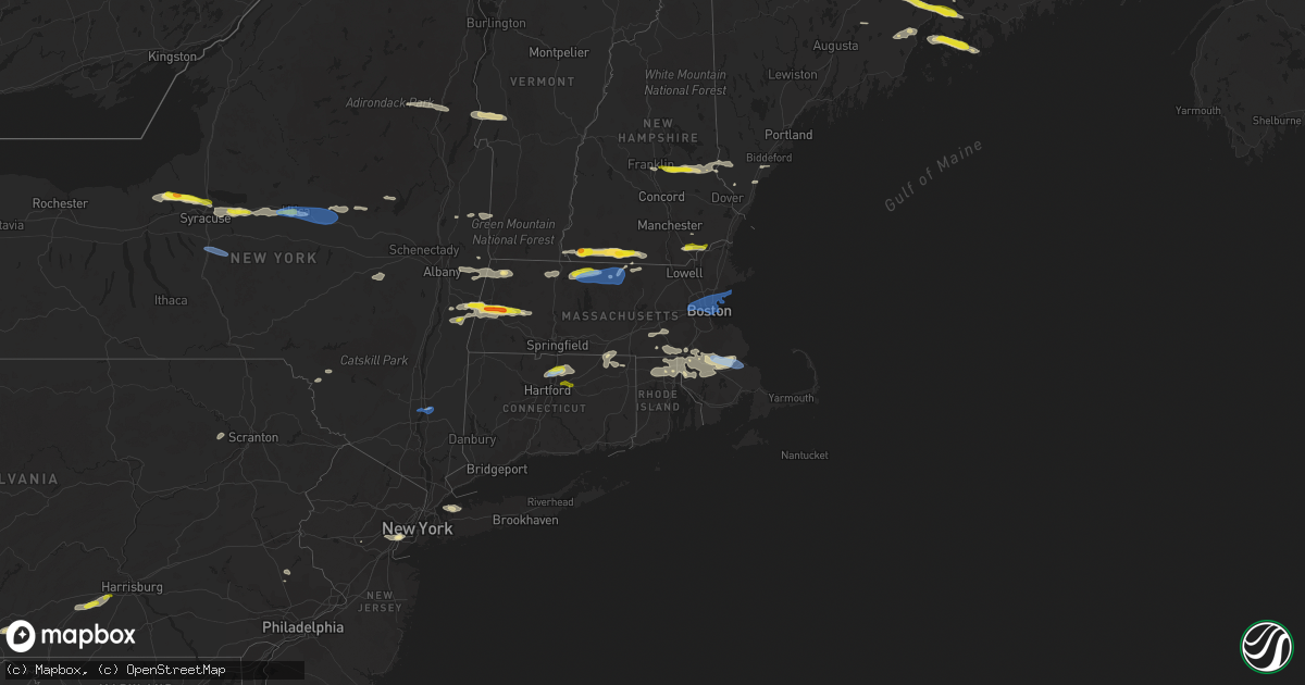
Hail Map in Massachusetts on June 30, 2021
Get this storm
June 30 map
$229
one time, instant access
Download today. No call, no setup
Keep the $229
Bought the map and want the full workflow? Apply the entire $229 to a subscription within 7 days. None of it is wasted.
Every map, not just this one
This buys you this map. Subscription and you get every map we run, in the markets you choose from a few cities to whole states to nationwide. Plus real-time alerts the moment a storm fires.
Contact data
Name, contact info, occupancy, even credit band for addresses in the footprint. You go from where it hit to who to call.
Become the source they trust
Unlimited branding weather history reports on demand. You already have the documented answer ready for the property owner, and you are the one who showed up with it.
Property data and RoofTrace estimates
Pull up any address you have got, its value and the exact code rules for that jurisdiction, straight from One Click Code. Then RoofTrace estimates the squares, pitch, and roof value, priced the way you price.
Storm reports in Massachusetts
Massachusetts
| Date | Description |
|---|---|
| 06/30/20216:16 PM CDT | Tree down across chase crescent... Off of rte 110 |
| 06/30/20216:00 PM CDT | Power lines down on beal street |
| 06/30/20215:43 PM CDT | Trees down on holbrook road at newport ave. Tree down on warren ave |
| 06/30/20215:36 PM CDT | Tree down on wires on center ave |
| 06/30/20215:27 PM CDT | Trees down on eastview street... Hayden rowe... And kerry lane |
| 06/30/20215:24 PM CDT | Trees down on corona street and wellesley park. Power lies down on harborview street in dorchester |
| 06/30/20215:20 PM CDT | Power lines down on jackson street |
| 06/30/20215:20 PM CDT | Tree down blocking road at hancock at central street |
| 06/30/20214:42 PM CDT | Large tree down on wires on sianai street |
| 06/30/20214:40 PM CDT | Tree down with poer pole snapped in half. Wires down on east broadway |
| 06/30/20214:39 PM CDT | Tree down on cross street |
| 06/30/20214:37 PM CDT | Tree dwon on acton road at high street |
| 06/30/20214:34 PM CDT | Tree and wires down across randall rd |
| 06/30/20214:30 PM CDT | Large tree down north brookfield road |
| 06/30/20214:25 PM CDT | Tree down blocking road at old cold brook road at walnut hill road |
| 06/30/20214:21 PM CDT | Trees down across randall rd |
| 06/30/20214:15 PM CDT | Transformer blown... Wires across road on pequoig ave |
| 06/30/20214:00 PM CDT | Tree down on house on jeri drive. Tree down on metroplolitan court |
| 06/30/20214:00 PM CDT | Tree branch down on wires on warwick rd |
| 06/30/20213:57 PM CDT | Tree down on wires huckerville road |
| 06/30/20213:55 PM CDT | Tree down blocking orange road |
| 06/30/20213:50 PM CDT | Tree down blocking south cross road |
| 06/30/20213:41 PM CDT | A local report indicates 58 MPH wind near ORANGE AP |
| 06/30/20213:27 PM CDT | Trees and wires down on montague city road near walnut street |
| 06/30/20213:21 PM CDT | Large tree and wires down in erving on french king highway |
| 06/30/20213:10 PM CDT | Several large trees down along route 8. |
| 06/30/20213:10 PM CDT | Several trees down |
| 06/30/20213:07 PM CDT | Several large trees down on route 8 and blocking washington mtn road. |
| 06/30/20213:05 PM CDT | Trees on wires and nearby residence. Time estimated by radar. |
| 06/30/20212:51 PM CDT | Numerous trees down... 15 reports... In richmond |
| 06/30/20212:50 PM CDT | Multiple trees down. Also west of town to route 41. |
| 06/30/20213:31 AM CDT | At 831 PM EDT, severe thunderstorms were located along a line extending from Walpole to Rehoboth, moving east at 35 mph. HAZARD...60 mph wind gusts. SOURCE...Radar indicated. IMPACT...Expect damage to trees and power lines. Locations impacted include... Brockton, Quincy, Plymouth, Taunton, Weymouth, Braintree, Randolph, Norwood, Milton, Stoughton, Bridgewater, Marshfield, Dedham, Walpole, Mansfield, Middleborough, Easton, Hingham, Wareham and Canton. |
| 06/30/20213:14 AM CDT | At 814 PM EDT, a severe thunderstorm was located over Rockland, or near Weymouth, moving east at 25 mph. HAZARD...60 mph wind gusts and quarter size hail. SOURCE...Radar indicated. IMPACT...Expect wind damage to trees and power lines. Minor hail damage to vehicles is possible. Locations impacted include... Boston, Quincy, Weymouth, Braintree, Randolph, Milton, Marshfield, Hingham, Scituate, Rockland, Abington, Hanover, Holbrook, Norwell, Hull and Cohasset. |
| 06/30/20211:45 AM CDT | At 644 PM EDT, a severe thunderstorm was located over East Windsor, or near South Windsor, moving east at 30 mph. HAZARD...60 mph wind gusts and penny size hail. SOURCE...Radar indicated. IMPACT...Expect damage to trees and power lines. Locations impacted include... Springfield, Manchester, Enfield, Vernon, Windsor, Agawam, Mansfield, South Windsor, Simsbury, Bloomfield, Avon, Longmeadow, Suffield, East Longmeadow, Ellington, Tolland, Windsor Locks, Coventry, Stafford and Somers. |
| 06/30/20211:12 AM CDT | At 612 PM EDT, a severe thunderstorm was located over Upton, or near Milford, moving east at 40 mph. HAZARD...60 mph wind gusts and quarter size hail. SOURCE...Radar indicated. IMPACT...Expect wind damage to trees and power lines. Minor hail damage to vehicles is possible. Locations impacted include... Boston, Quincy, Framingham, Weymouth, Braintree, Shrewsbury, Natick, Randolph, Needham, Norwood, Milford, Wellesley, Milton, Stoughton, Dedham, Walpole, Hingham, Canton, Westborough and Grafton. |
| 06/30/202112:54 AM CDT | At 553 PM EDT, a severe thunderstorm was located over Northborough, or near Marlborough, moving east at 35 mph. HAZARD...60 mph wind gusts. SOURCE...Radar indicated. IMPACT...Expect damage to trees and power lines. Locations impacted include... Boston, Worcester, Cambridge, Quincy, Newton, Somerville, Framingham, Waltham, Malden, Brookline, Medford, Weymouth, Revere, Arlington, Everett, Marlborough, Braintree, Shrewsbury, Chelsea and Natick. |
| 06/30/202112:43 AM CDT | At 543 PM EDT, a severe thunderstorm was located over Carlisle, or over Chelmsford, moving east at 25 mph. HAZARD...60 mph wind gusts and penny size hail. SOURCE...Radar indicated. IMPACT...Expect damage to trees and power lines. Locations impacted include... Lowell, Lynn, Malden, Medford, Revere, Peabody, Arlington, Everett, Salem, Billerica, Beverly, Woburn, Chelmsford, Andover, Lexington, Dracut, Tewksbury, North Andover, Melrose and Saugus. |
| 06/30/202112:29 AM CDT | At 528 PM EDT, a severe thunderstorm was located over Oakham, or 10 miles west of Worcester, moving east at 25 mph. HAZARD...60 mph wind gusts and penny size hail. SOURCE...Radar indicated. IMPACT...Expect damage to trees and power lines. Locations impacted include... Worcester, Framingham, Marlborough, Shrewsbury, Milford, Hudson, Westborough, Grafton, Holden, Auburn, Hopkinton, Northborough, Clinton, Millbury, Spencer, Leicester, Southborough, Rutland, Sterling and West Boylston. |
| 06/30/202112:13 AM CDT | At 513 PM EDT, a severe thunderstorm was located over Westminster, or near Fitchburg, moving east at 25 mph. HAZARD...60 mph wind gusts and quarter size hail. SOURCE...Trained weather spotters have reported a history of wind damage with these storms. IMPACT...Expect wind damage to trees and power lines. Minor hail damage to vehicles is possible. Locations impacted include... Leominster, Fitchburg, Westford, Acton, Gardner, Concord, Sudbury, Holden, Clinton, Pepperell, Tyngsborough, Groton, Maynard, Lunenburg, Townsend, Littleton, Lancaster, Rutland, Sterling and Ayer. |
| 06/30/202112:12 AM CDT | At 512 PM EDT, a severe thunderstorm was located over Nashua, moving east at 30 mph. HAZARD...60 mph wind gusts and half dollar size hail. SOURCE...Radar indicated. IMPACT...Hail damage to vehicles is expected. Expect wind damage to roofs, siding, and trees. Locations impacted include... Nashua, Derry, Merrimack, Salem, Amherst, Litchfield, Hollis, Hudson, Pelham, Seabrook, Londonderry, Hampstead, Atkinson, Kingston, Windham, Plaistow, Newton and South Hampton.This includes the following highways... Interstate 93 between mile markers 0 and 11. Interstate 95 in New Hampshire near mile marker 0. |
| 06/30/202112:00 AM CDT | At 500 PM EDT, a severe thunderstorm was located over Townsend, or 7 miles northeast of Fitchburg, moving east at 20 mph. HAZARD...60 mph wind gusts and quarter size hail. SOURCE...Radar indicated. IMPACT...Expect wind damage to trees and power lines. Minor hail damage to vehicles is possible. Locations impacted include... Fitchburg, Pepperell, Tyngsborough, Groton, Lunenburg, Townsend, Dunstable and Ashby. |
| 06/29/202111:58 PM CDT | At 458 PM EDT, a severe thunderstorm was located over Exeter, moving east at 45 mph. HAZARD...60 mph wind gusts and quarter size hail. SOURCE...Radar indicated. IMPACT...Hail damage to vehicles is expected. Expect wind damage to roofs, siding, and trees. Locations impacted include... Portsmouth, Hampton, Exeter, Brentwood, Greenland, Stratham, Seabrook, Rye, Kingston, East Kingston, Hampton Falls, Kensington, North Hampton, Newton, South Hampton and Newfields.This includes Interstate 95 in New Hampshire between mile markers 1and 11. This also includes... Hampton Beach. |
| 06/29/202111:39 PM CDT | At 439 PM EDT, a severe thunderstorm was located over Northampton, moving east at 25 mph. HAZARD...60 mph wind gusts and quarter size hail. SOURCE...Radar indicated. IMPACT...Expect wind damage to trees and power lines. Minor hail damage to vehicles is possible. Locations impacted include... Chicopee, Holyoke, Amherst, Northampton, Deerfield, Ludlow, South Hadley, Easthampton, Belchertown, Wilbraham, Charlton, Palmer, Spencer, Ware, Sturbridge, Rutland, Granby, Southampton, Barre and Hadley. |
| 06/29/202111:25 PM CDT | At 425 PM EDT, a severe thunderstorm was located over Jaffrey, moving east at 40 mph. HAZARD...Ping pong ball size hail and 60 mph wind gusts. SOURCE...Radar indicated. IMPACT...People and animals outdoors will be injured. Expect hail damage to roofs, siding, windows, and vehicles. Expect wind damage to roofs, siding, and trees. Locations impacted include... Nashua, Jaffrey, Merrimack, Bedford, Milford, Amherst, Hollis, Peterborough, New Boston, Mont Vernon, Greenfield, Lyndeborough, Dublin, Rindge, New Ipswich, Sharon, Mount Vernon, Greenville, Wilton and Brookline.This also includes... Mount Monadnock and North Pack Monadnock. |
| 06/29/202111:09 PM CDT | At 408 PM EDT, a severe thunderstorm was located over Becket, or 11 miles southeast of Pittsfield, moving east at 30 mph. This is a very dangerous storm. HAZARD...80 mph wind gusts and golf ball size hail. SOURCE...Radar indicated. IMPACT...Flying debris will be dangerous to those caught without shelter. Mobile homes will be heavily damaged. Expect considerable damage to roofs, windows, and vehicles. Extensive tree damage and power outages are likely. Locations impacted include... Becket, Washington, Bonny Rigg Corners and Becket Center. |
| 06/29/202111:05 PM CDT | At 404 PM EDT, severe thunderstorms were located along a line extending from 9 miles west of Walpole to 13 miles west of Hinsdale, moving east at 35 mph. HAZARD...60 mph wind gusts and quarter size hail. SOURCE...Radar indicated. IMPACT...Hail damage to vehicles is expected. Expect wind damage to roofs, siding, and trees. Locations impacted include... Keene, Jaffrey, Peterborough, Charlestown, Winchester, Antrim, Bradford, Dublin, Richmond, Harrisville, Nelson, Gilsum, Marlborough, Rindge, Walpole, Alstead, Westmoreland, Swanzey, Marlow and Hinsdale.This also includes... Mount Monadnock. |
| 06/29/202111:01 PM CDT | At 400 PM EDT, a severe thunderstorm was located near New Ashford, or 9 miles southwest of North Adams, moving east at 35 mph. HAZARD...60 mph wind gusts and quarter size hail. SOURCE...Radar indicated. IMPACT...Hail damage to vehicles is expected. Expect wind damage to roofs, siding, and trees. Locations impacted include... North Adams, Adams, Williamstown, Cheshire, Berlin, Florida, Hancock, Savoy, New Ashford, Hairpin Turn, Greylock, North Stephentown, Sweets Corner, Soldiers Memorial Field, North Hancock, Cheshire Harbor, Arnoldville, Town Crest Village, Maple Grove and Center Berlin. |
| 06/29/202110:48 PM CDT | At 347 PM EDT, a severe thunderstorm was located near Florida, or near North Adams, moving east at 20 mph. HAZARD...60 mph wind gusts and penny size hail. SOURCE...Radar indicated. IMPACT...Expect damage to roofs, siding, and trees. Locations impacted include... North Adams, Florida, Savoy Center, Little Egypt, Whitcomb Summit, Eastern Summit, West Summit, North Adams State College Athletic Field, Drury and Brier. |
| 06/29/202110:48 PM CDT | At 347 PM EDT, a severe thunderstorm was located over Lenox, or near Pittsfield, moving east at 35 mph. HAZARD...60 mph wind gusts and quarter size hail. SOURCE...Radar indicated. IMPACT...Expect wind damage to trees and power lines. Minor hail damage to vehicles is possible. Locations impacted include... Chicopee, Westfield, Holyoke, Northampton, West Springfield, Deerfield, South Hadley, Easthampton, Southampton, Hadley, Sunderland, Hatfield, Williamsburg, Huntington, Conway, Russell, Ashfield, Westhampton, Whately and Chester. |
| 06/29/202110:35 PM CDT | At 335 PM EDT, a severe thunderstorm was located near Austerlitz, or 8 miles east of Chatham, moving east at 25 mph. HAZARD...60 mph wind gusts and penny size hail. SOURCE...Radar indicated. IMPACT...Expect damage to roofs, siding, and trees. Locations impacted include... Pittsfield, Lee, Lenox, Becket, Dalton, Hinsdale, Canaan, Richmond, West Stockbridge, Peru, Washington, Barkerville, Mahkeenac Heights, Tanglewood, New Lenox, Lenox Dale, The Boulders, The Center At Lenox, Adams Junction and Yankee Orchards. |
| 06/29/20218:15 PM CDT | Tree and power lines down on river road |
| 06/29/20218:05 PM CDT | Trees down on fuller street. Tree down on south street |
| 06/29/20218:00 PM CDT | Power lines down kilysyth road |
| 06/29/20217:50 PM CDT | Tree down on garage on norlen park. Tree and power lines down on conant street |
| 06/29/20217:45 PM CDT | Multiple trees and wires down on norton ave |
| 06/29/20217:33 PM CDT | Tree and wires down on pratt street |
All States Impacted by Hail Map on June 30, 2021
Cities Impacted by Hail Map on June 30, 2021
- Orwell, VT
- Brandon, VT
- Lawrenceville, IL
- Waterbury, VT
- Williston, VT
- Shelburne, VT
- South Burlington, VT
- Richmond, VT
- Carlisle, PA
- Boiling Springs, PA
- Eclectic, AL
- Grafton, MA
- Holliston, MA
- Milford, MA
- Upton, MA
- South Grafton, MA
- Northbridge, MA
- Hopkinton, MA
- Sedgwick, ME
- Blue Hill, ME
- Sargentville, ME
- Brooksville, ME
- Harborside, ME
- Brooklin, ME
- Pittsfield, MA
- Richmond, MA
- Mitchell, OR
- Grand Marais, MN
- Tennyson, IN
- Wallace, MI
- Menominee, MI
- Raynham, MA
- South Easton, MA
- Wendell, MA
- Royalston, MA
- Athol, MA
- Orange, MA
- Northfield, MA
- Erving, MA
- Warwick, MA
- Enoree, SC
- Burlington, WV
- Purgitsville, WV
- Dixmont, ME
- Brooks, ME
- Troy, ME
- Monroe, ME
- Dolgeville, NY
- Johnstown, NY
- Caroga Lake, NY
- Saint Johnsville, NY
- Bridgewater, MA
- West Bridgewater, MA
- Halifax, MA
- Middleboro, MA
- Plympton, MA
- Zalma, MO
- Patton, MO
- Jaffrey, NH
- New Ipswich, NH
- Rindge, NH
- Mathias, WV
- Greenleaf, WI
- North Dighton, MA
- Rehoboth, MA
- East Taunton, MA
- Taunton, MA
- Windham, NH
- Chatham, NY
- Ghent, NY
- Elizabethport, NJ
- Elizabeth, NJ
- Staten Island, NY
- Linden, NJ
- Lenox, MA
- Baldwinville, MA
- Gardner, MA
- Winchendon, MA
- Hedgesville, WV
- Gerrardstown, WV
- Kirkville, NY
- Chittenango, NY
- Oneida, NY
- Canastota, NY
- Wampsville, NY
- Ellington, CT
- East Windsor, CT
- Broad Brook, CT
- Windsor Locks, CT
- Windsor, CT
- Athens, OH
- Putnam Station, NY
- Mansfield, MA
- Pittsford, VT
- Chittenden, VT
- Killington, VT
- Stockbridge, VT
- Pittsfield, VT
- Marble Hill, MO
- Glenallen, MO
- Searsmont, ME
- Morrill, ME
- Belfast, ME
- Lincolnville, ME
- Woodstock, CT
- Woodstock Valley, CT
- Baldwinsville, NY
- Broadway, VA
- Waynesburg, KY
- Jacobsburg, OH
- Bellaire, OH
- Saint Clairsville, OH
- Neffs, OH
- Liverpool, NY
- Clay, NY
- Cato, NY
- Fulton, NY
- Phoenix, NY
- Surry, ME
- Penobscot, ME
- Bucksport, ME
- Orland, ME
- Lee, MA
- Becket, MA
- Adams, MA
- North Attleboro, MA
- Attleboro, MA
- Norton, MA
- Peterborough, NH
- Berwick, ME
- Crown King, AZ
- Xenia, IL
- Louisville, IL
- Flora, IL
- Winchester, VA
- Cross Junction, VA
- New Hartford, NY
- Utica, NY
- New York Mills, NY
- Yorkville, NY
- Whitesboro, NY
- Clinton, NY
- Hermansville, MI
- Winterport, ME
- Stockton Springs, ME
- Burnham, ME
- Frankfort, ME
- Metropolis, IL
- Smithfield, RI
- Pawtucket, RI
- Central Falls, RI
- Lincoln, RI
- Providence, RI
- Cumberland, RI
- Newville, PA
- Sea Cliff, NY
- Glen Cove, NY
- Port Washington, NY
- Glen Head, NY
- Mayfield, NY
- Stephentown, NY
- Sand Lake, NY
- Lanesborough, MA
- Savoy, MA
- Poestenkill, NY
- Berlin, NY
- Williamstown, MA
- North Adams, MA
- Averill Park, NY
- Petersburg, NY
- East Bridgewater, MA
- North Easton, MA
- Eubank, KY
- Riggins, ID
- Tilton, NH
- Gilmanton, NH
- Center Barnstead, NH
- Milton, NH
- Loudon, NH
- Lebanon, ME
- Barnstead, NH
- Union, NH
- Alton, NH
- Belmont, NH
- Farmington, NH
- Springvale, ME
- New Durham, NH
- Sanford, ME
- Canterbury, NH
- Gilmanton Iron Works, NH
- Wells, ME
- McDonald, PA
- Presto, PA
- Oakdale, PA
- Pittsburgh, PA
- Carnegie, PA
- Cuddy, PA
- Morgan, PA
- Bridgeville, PA
- Bethel Park, PA
- Albany, OH
- New Marshfield, OH
- West Stockbridge, MA
- East Chatham, NY
- Canaan, NY
- Gwinn, MI
- Rock, MI
- Needmore, PA
- Warfordsburg, PA
- Winchester, NH
- Swanzey, NH
- Lenox Dale, MA
- Hinsdale, MA
- Grayson, KY
- Caldwell, OH
- Adrian, TX
- Schuylerville, NY
- Franklin, MA
- Rapid River, MI
- Gladstone, MI
- Perkins, MI
- Ballston Spa, NY
- Burnt Hills, NY
- Ballston Lake, NY
- Bluemont, VA
- Upperville, VA
- Paris, VA
- Poughkeepsie, NY
- Wappingers Falls, NY
- Seal Cove, ME
- Southwest Harbor, ME
- Bernard, ME
- Castine, ME
- Schroon Lake, NY
- Minerva, NY
- Olmstedville, NY
- Ashburnham, MA
- Sherman, ME
- Brillion, WI
- Greenville, NH
- Arlington, VT
- Shushan, NY
- Cambridge, NY
- Wilton, NH
- Troy, NH
- Brookline, NH
- Temple, NH
- Fitzwilliam, NH
- Lovettsville, VA
- Leesburg, VA
- Zanesville, OH
- Adamsville, OH
- Capon Bridge, WV
- Augusta, WV
- Mendon, MA
- Wrentham, MA
- Blackstone, MA
- Bellingham, MA
- Plainville, MA
- Point Of Rocks, MD
- Waterford, VA
- Tuscarora, MD
- Purcellville, VA
- Round Hill, VA
- Harpers Ferry, WV
- McArthur, OH
- Clark Mills, NY
- Harveys Lake, PA
- Tunkhannock, PA
- Noxen, PA
- Dallas, PA
- Martinsville, NJ
- Greenfield, MA
- Shelburne Falls, MA
- Colrain, MA
- Albion, ME
- South China, ME
- Middlefield, MA
- Chester, MA
- Vulcan, MI
- Carney, MI
- Vernon, NY
- Minoa, NY
- Westmoreland, NY
- Vernon Center, NY
- Sherrill, NY
- Frankfort, NY
- East Syracuse, NY
- Fayetteville, NY
- Verona, NY
- Brattleboro, VT
- Haverhill, MA
- Atkinson, NH
- Salem, NH
- Plaistow, NH
- Petersburg, IN
- Washington, IN
- Thompson, CT
- North Grosvenordale, CT
- Kings Mountain, KY
- Huntington, MA
- Sandown, NH
- Chester, NH
- West Townsend, MA
- Ashby, MA
- Shippensburg, PA
- Mount Holly Springs, PA
- Greenwich, NY
- West Paducah, KY
- Seekonk, MA
- Oconto, WI
- Ashuelot, NH
- Vernon, VT
- Hinsdale, NH
- Crystal Spring, PA
- Breezewood, PA
- Natural Bridge Station, VA
- Green Spring, WV
- Kaukauna, WI
- Tallassee, AL
- Livingston Manor, NY
- Roscoe, NY
- Stafford Springs, CT
- Southbridge, MA
- Eastford, CT
- Souderton, PA
- McConnellsburg, PA
- Harrisonville, PA
- Barnesville, OH
- Quaker City, OH
- Canonsburg, PA
- Venetia, PA
- Senecaville, OH
- Ticonderoga, NY
- Kennebunkport, ME
- Fultonham, NY
- Schoharie, NY
- Warnerville, NY
- Middleburgh, NY
- Perkasie, PA
- Sellersville, PA
- Ellsworth, ME
- Foxboro, MA
- Boyce, VA
- Front Royal, VA
- White Post, VA
- Fremont Center, NY
- North Branch, NY
- Callicoon, NY
- Nashport, OH
- Chillicothe, OH
- Laurelville, OH
- Valatie, NY
- Chesterfield, MA
- Hillsdale, NY
- Austerlitz, NY
- Old Chatham, NY
- Stockbridge, MA
- Spencertown, NY
- West Chesterfield, MA
- Worthington, MA
- Kinderhook, NY
- Gore, VA
- Little Falls, NY
- Walnut Bottom, PA
- Oyster Bay, NY
- Locust Valley, NY
- Glenwood Landing, NY
- Clark, NJ
- Bayonne, NJ
- Garwood, NJ
- Cranford, NJ
- Westfield, NJ
- Rahway, NJ
- Roselle, NJ
- Franklin, NH
- Benwood, WV
- Wheeling, WV
- North Lawrence, OH
- Massillon, OH
- Canal Fulton, OH
- Chepachet, RI
- Berkley, MA
- Woonsocket, RI
- Attleboro Falls, MA
- Manville, RI
- Johnston, RI
- North Scituate, RI
- Greenville, RI
- Sharon, MA
- North Providence, RI
- Albion, RI
- North Smithfield, RI
- Kingston, MA
- South Windsor, CT
- Bloomfield, CT
- Tolland, CT
- Stephenson, MI
- Red Creek, NY
- Syracuse, NY
- Martville, NY
- Cicero, NY
- Detroit, ME
- Mechanicsburg, PA
- Dresden, OH
- Old Washington, OH
- New Concord, OH
- Cambridge, OH
- Kipling, OH
- Adena, OH
- Dillonvale, OH
- Kimbolton, OH
- Piedmont, OH
- Salesville, OH
- Mount Pleasant, OH
- Norwich, OH
- Byesville, OH
- Morristown, OH
- Bethesda, OH
- Flushing, OH
- Rayland, OH
- Freeport, OH
- Belmont, OH
- Lore City, OH
- Cadiz, OH
- Avella, PA
- Coraopolis, PA
- Bulger, PA
- Langeloth, PA
- Imperial, PA
- Burgettstown, PA
- Colliers, WV
- Wellsburg, WV
- Joffre, PA
- Bethany, WV
- Atlasburg, PA
- Midway, PA
- Slovan, PA
- Chester, WV
- Lisbon, OH
- Wellsville, OH
- East Liverpool, OH
- Salineville, OH
- Industry, PA
- Ilion, NY
- Herkimer, NY
- Mohawk, NY
- Marcy, NY
- Truxton, NY
- Apulia Station, NY
- La Fayette, NY
- Tully, NY
- Fabius, NY
- De Ruyter, NY
- Marlboro, NY
- Ponca City, OK
- Blackwell, OK
- Escanaba, MI
- Wells, MI
- Templeton, MA
- Westminster, MA
- Wendell Depot, MA
- Revere, MA
- Stoneham, MA
- Swampscott, MA
- Marblehead, MA
- Somerville, MA
- Nahant, MA
- Belmont, MA
- Lexington, MA
- West Newton, MA
- Charlestown, MA
- Winchester, MA
- Waltham, MA
- Winthrop, MA
- Malden, MA
- Newtonville, MA
- Saugus, MA
- Allston, MA
- East Boston, MA
- Watertown, MA
- Chelsea, MA
- Everett, MA
- Cambridge, MA
- Salem, MA
- Auburndale, MA
- Boston, MA
- Brighton, MA
- Lynn, MA
- Medford, MA
- Arlington, MA
- Melrose, MA
- Newton, MA
- South Boston, MA
- Plymouth, MA
- Carver, MA
- Newton, NH
- Derry, NH
- Manchester, CT
- Vernon Rockville, CT
- Bolton, CT


