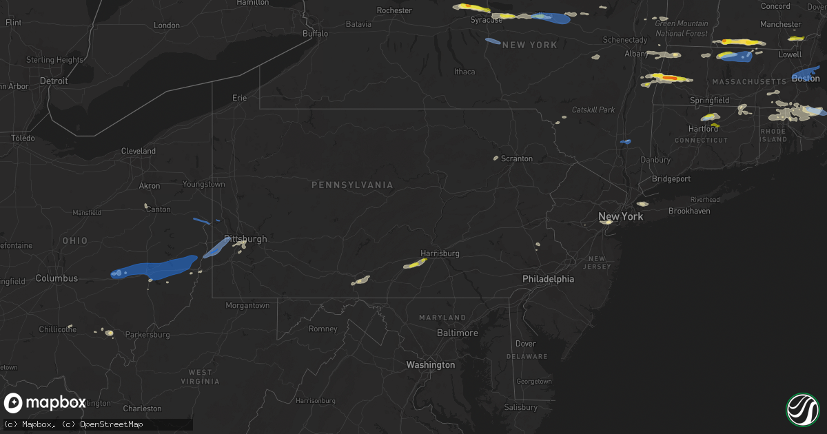
Hail Map in Pennsylvania on June 30, 2021
Get this storm
June 30 map
$229
one time, instant access
Download today. No call, no setup
Keep the $229
Bought the map and want the full workflow? Apply the entire $229 to a subscription within 7 days. None of it is wasted.
Every map, not just this one
This buys you this map. Subscription and you get every map we run, in the markets you choose from a few cities to whole states to nationwide. Plus real-time alerts the moment a storm fires.
Contact data
Name, contact info, occupancy, even credit band for addresses in the footprint. You go from where it hit to who to call.
Become the source they trust
Unlimited branding weather history reports on demand. You already have the documented answer ready for the property owner, and you are the one who showed up with it.
Property data and RoofTrace estimates
Pull up any address you have got, its value and the exact code rules for that jurisdiction, straight from One Click Code. Then RoofTrace estimates the squares, pitch, and roof value, priced the way you price.
Storm reports in Pennsylvania
Pennsylvania
| Date | Description |
|---|---|
| 06/30/20216:05 PM CDT | Several trees down on swatara creek rd. |
| 06/30/20215:55 PM CDT | Multiple reports of trees down across upper and lower allen townships. |
| 06/30/20215:50 PM CDT | Multiple reports of trees down across monroe township. |
| 06/30/20215:42 PM CDT | Multiple trees and wires down on sandbank rd. |
| 06/30/20215:36 PM CDT | Multiple trees down on pine rd. |
| 06/30/20215:35 PM CDT | Multiple trees and wires down across dickinson township. |
| 06/30/20215:18 PM CDT | Report of a snapped tree and limbs down in industry. |
| 06/30/20214:45 PM CDT | Trees down on turkey rd. |
| 06/30/20214:42 PM CDT | Trees down. |
| 06/30/20214:40 PM CDT | Trees down and wires on w wood st. |
| 06/30/20214:38 PM CDT | Multiple trees down. |
| 06/30/20214:20 PM CDT | Numerous trees and wires down across the counties. |
| 06/30/20213:55 PM CDT | Trees down. |
| 06/30/20213:52 PM CDT | Scott... Pa. Downed trees. 2ne clarks green. |
| 06/30/20213:26 PM CDT | Outbuilding destroyed on fairsom ct in east buffalo township. |
| 06/30/20213:21 PM CDT | Roof blown off building. |
| 06/30/20212:55 PM CDT | Corrects previous tstm wnd dmg report from ulster. Multiple trees down. Time estimated by radar. |
| 06/30/20212:55 PM CDT | Trees down on horn brook road. |
| 06/30/20212:52 PM CDT | Trees down across road near hornbrook park. |
| 06/30/20212:33 PM CDT | Report of multiple trees down around republic. |
| 06/30/20211:57 PM CDT | Report of tree down on residential structure. Time estimated based on radar. |
| 06/30/20211:52 PM CDT | Report shows large tree branches down and power outages. Time estimated based on radar. |
| 06/30/20211:43 PM CDT | Report of multiple trees down on perry road. Time estimated based on radar. |
| 06/30/20211:40 PM CDT | Trees on wires. |
| 06/30/20211:34 PM CDT | Trained spotter reported gusts in around or in excess of 60 mph in claysville. |
| 06/30/20211:19 PM CDT | Fire chief reporting tree down at intersection of county road and roman road. Time estimated based on radar. |
| 06/30/20211:04 PM CDT | Report of multiple trees down around the area. Time estimated based on radar. |
| 06/30/202112:55 PM CDT | Report of tree down on wires due to wind. Time estimated based on radar. |
| 06/30/202112:50 PM CDT | Report on tree down on roadway. Time estimated based on radar. |
| 06/30/202112:29 PM CDT | Em reporting sporadic trees and power lines down throughout county. |
| 06/30/202112:17 PM CDT | Report of tree and powerlines down on the 2800 block of sarah street. Time estimated based on radar. |
| 06/30/202112:15 PM CDT | A local report indicates 1.00 inch wind near SOUTH SIDE FLATS |
| 06/30/20217:11 AM CDT | At 1211 AM EDT, a severe thunderstorm was located over New Albany, or 11 miles southwest of Wyalusing, moving east at 35 mph. HAZARD...60 mph wind gusts. SOURCE...Radar indicated. IMPACT...Expect damage to roofs, siding, and trees. Locations impacted include... Wilmot, Hollenback, Wyalusing, Monroe, New Albany, Overton, Monroeton, Sugar Run, Franklindale and South Branch. |
| 06/30/20211:27 AM CDT | At 626 PM EDT, a severe thunderstorm was located near Walnut Bottom, moving east at 45 mph. HAZARD...60 mph wind gusts and quarter size hail. SOURCE...Radar indicated. IMPACT...Hail damage to vehicles is expected. Expect wind damage to roofs, siding, and trees. Locations impacted include... Harrisburg, Carlisle, Lower Allen, Mechanicsburg, Camp Hill, New Cumberland, Enola, Lemoyne, Plainfield, Schlusser, Boiling Springs, Wormleysburg, Mount Holly Springs, Shiremanstown, Newville, West Fairview, New Kingstown, Hogestown, Walnut Bottom and Pine Grove Furnace.This includes the following Interstates... The Pennsylvania Turnpike from mile markers 221 to 239. Interstate 81 from mile markers 31 to 55. Interstate 83 from mile markers 40 to 42. |
| 06/30/202112:49 AM CDT | At 549 PM EDT, a severe thunderstorm was located over Peabrook, or 16 miles south of Walton, moving east at 45 mph. HAZARD...60 mph wind gusts and quarter size hail. SOURCE...Radar indicated. IMPACT...Hail damage to vehicles is expected. Expect wind damage to roofs, siding, and trees. Locations impacted include... Rockland, Fremont, Parksville, Stalker, Hazel, Equinunk, Grahamsville, Willowemoc, Peabrook and Fishs Eddy. |
| 06/30/202112:24 AM CDT | At 524 PM EDT, a severe thunderstorm was located near Locust Grove, moving east at 25 mph. HAZARD...60 mph wind gusts and penny size hail. SOURCE...Radar indicated. IMPACT...Expect damage to roofs, siding, and trees. Locations impacted include... St. Thomas, Mercersburg, McConnellsburg, Harrisonville, Marion, Fort Loudon, Big Cove Tannery, Crystal Springs, Needmore, Saluvia, Locust Grove, Fannettsburg and Williamson.This includes the following Interstates... Interstate 70 from mile markers 151 to 162. Interstate 81 from mile markers 9 to 11. |
| 06/29/202111:33 PM CDT | At 432 PM EDT, a severe thunderstorm was located over Le Raysville, or 12 miles northeast of Wyalusing, moving east at 30 mph. HAZARD...60 mph wind gusts and penny size hail. SOURCE... Reports of downed trees and wires in Bradford county with this storm. IMPACT...Expect damage to roofs, siding, and trees. Locations impacted include... Rush, Montrose, Dimock, Harford, Hallstead, New Milford, Herrick, Hop Bottom, Le Raysville and Friendsville. |
| 06/29/202111:32 PM CDT | At 432 PM EDT, a severe thunderstorm was located over Falls, or near Tunkhannock, moving northeast at 40 mph. HAZARD...60 mph wind gusts and half dollar size hail. SOURCE...Radar indicated. IMPACT...Hail damage to vehicles is expected. Expect wind damage to roofs, siding, and trees. Locations impacted include... Scranton, Falls, Dunmore, Carbondale, Archbald, Blakely, Taylor, Dickson City, Vernon and Olyphant. |
| 06/29/202110:54 PM CDT | At 354 PM EDT, severe thunderstorms were located along a line extending from near Litchfield to near Le Roy, moving east at 30 mph. HAZARD...60 mph wind gusts and quarter size hail. SOURCE...Radar indicated. IMPACT...Hail damage to vehicles is expected. Expect wind damage to roofs, siding, and trees. Locations impacted include... Towanda, West Franklin, Wysox, Sheshequin, Ulster, Wilmot, Orwell, North Towanda, Herrick and West Burlington. |
| 06/29/202110:46 PM CDT | At 345 PM EDT, a severe thunderstorm was located over R.B. Winter State Park, moving east at 30 mph. HAZARD...60 mph wind gusts and penny size hail. SOURCE...Radar indicated. IMPACT...Expect damage to roofs, siding, and trees. Locations impacted include... Sunbury, Milton, Lewisburg, Northumberland, Mifflinburg, Winfield, Shamokin Dam, Linntown, Hummels Wharf, New Columbia, Montandon, Penns Creek, Kratzerville, Vicksburg, R.B. Winter State Park, Forest Hill, Sand Bridge State Park, Spruce Run Reservoir, Laurelton Center and West Milton.For those driving on Interstate 80, this includes areas between theJersey Shore and Danville exits, specifically between mile markers195 and 198...and from mile markers 209 to 218. |
| 06/29/20219:45 PM CDT | At 245 PM EDT, a severe thunderstorm was located over Black Lick, or near Homer City, moving east at 20 mph. HAZARD...Wind gusts to 60 mph. SOURCE...Radar. IMPACT...Expect damage to trees and power lines, resulting in some power outages. Locations impacted include... Homer City... Blairsville... Black Lick... New Florence... Seward... Bolivar... Vintondale... Armagh... Lucerne Mines... Brush Vly... |
| 06/29/20219:41 PM CDT | At 241 PM EDT, a severe thunderstorm was located near Avella, moving northeast at 40 mph. HAZARD...Wind gusts to 70 mph. SOURCE...Radar. IMPACT...Trees snapped and uprooted. Power outages can be expected. Locations impacted include... Pittsburgh... Mount Lebanon... Bethel Park... Ross Township... Moon Township... Franklin Park... Canonsburg... North Side Pittsburgh... Upper St. Clair... Scott Township... Whitehall... Robinson Township...This includes the following highways... Interstate 79 in Pennsylvania between mile markers 48 and 69. Interstate 376 in Pennsylvania between mile markers 49 and 70. |
| 06/29/20219:37 PM CDT | At 237 PM EDT, a severe thunderstorm was located near Homer City, moving east at 10 mph. HAZARD...Wind gusts to 60 mph. SOURCE...Radar. IMPACT...Expect damage to trees and power lines, resulting in some power outages. Locations impacted include... Homer City... Lucerne Mines... Brush Vly... Yellow Creek State Park... |
| 06/29/20219:26 PM CDT | At 225 PM EDT, a severe thunderstorm was located over Wellsburg, moving east at 40 mph. HAZARD...Wind gusts to 60 mph. SOURCE...Radar. IMPACT...Expect damage to trees and power lines, resulting in some power outages. Locations impacted include... Wheeling... Weirton... Steubenville... Martins Ferry... Bellaire... Warwood... Wellsburg... Bethlehem... West Liberty... Triadelphia... Avella... Clearview...This includes the following highways... Interstate 70 in Ohio between mile markers 224 and 225. Interstate 70 in West Virginia between mile markers 0 and 14. Interstate 70 in Pennsylvania between mile markers 0 and 14. |
| 06/29/20219:25 PM CDT | At 225 PM EDT, a severe thunderstorm was located near Northern Cambria, moving east at 20 mph. HAZARD...60 mph wind gusts and penny size hail. SOURCE...Radar indicated. IMPACT...Expect damage to roofs, siding, and trees. Locations impacted include... Northern Cambria, Patton, Hastings, Carrolltown, Prince Gallitzin State Park and Chest Springs. |
| 06/29/20219:14 PM CDT | At 214 PM EDT, a severe thunderstorm was located near Jersey Shore, moving east at 30 mph. HAZARD...60 mph wind gusts. SOURCE...Radar indicated. IMPACT...Expect damage to roofs, siding, and trees. Locations impacted include... Williamsport, Montoursville, Jersey Shore, Muncy, Montgomery, Avis, Duboistown, McElhattan, Elimsport, Waterville, Cogan Station, Collomsville, Trout Run, Loyalsockville, South Williamsport, Garden View, Oval, Salladasburg, Williamsport Airport and Little League World Series Complex.This includes Interstate 180 from mile markers 9 to 29. |
| 06/29/20219:03 PM CDT | At 203 PM EDT, a severe thunderstorm was located near Delmont, or 7 miles southeast of Apollo, moving east at 10 mph. HAZARD...Wind gusts to 60 mph. SOURCE...Radar. IMPACT...Expect damage to trees and power lines, resulting in some power outages. Locations impacted include... Avonmore... Saltsburg... New Alexandria... Slickville... |
| 06/29/20218:23 PM CDT | At 123 PM EDT, a severe thunderstorm was located over Munhall, or near McKeesport, moving east at 25 mph. HAZARD...Wind gusts to 60 mph and quarter-size hail. SOURCE...Radar. IMPACT...Minor hail damage to vehicles is possible. Expect wind damage to trees and power lines, resulting in some power outages. Locations impacted include... Pittsburgh... Penn Hills... Mount Lebanon... Bethel Park... Monroeville... McMurray... McKeesport... Jeannette... Gastonville... Plum... West Mifflin... Baldwin...This includes the following highways... Interstate 70 in Pennsylvania between mile markers 50 and 56. Pennsylvania Turnpike between mile markers 51 and 74. Interstate 79 in Pennsylvania near mile marker 50. Interstate 376 in Pennsylvania between mile markers 74 and 84. |
| 06/29/20218:08 PM CDT | Downed trees or limbs near cobalt ridge drive. Time estimated from radar. |
| 06/29/20218:06 PM CDT | At 106 PM EDT, a severe thunderstorm was located over Upper St. Clair, or over Mount Lebanon, moving east at 25 mph. HAZARD...Wind gusts to 60 mph and quarter-size hail. SOURCE...Radar. IMPACT...Minor hail damage to vehicles is possible. Expect wind damage to trees and power lines, resulting in some power outages. Locations impacted include... Pittsburgh... Penn Hills... Mount Lebanon... Bethel Park... Monroeville... McMurray... McKeesport... Gastonville... Plum... West Mifflin... North Side Pittsburgh... Baldwin...This includes the following highways... Pennsylvania Turnpike between mile markers 51 and 59. Interstate 79 in Pennsylvania near mile marker 47, and between mile markers 49 and 60. Interstate 376 in Pennsylvania between mile markers 62 and 84. |
| 06/29/20218:05 PM CDT | Downed wires and power outages near miller street. Time estimated from radar. |
| 06/29/20217:56 PM CDT | Downed tree on taylorsville road. Time estimated from radar. |
| 06/29/20217:50 PM CDT | Downed trees and wires near atwood road. Time estimated from radar. |
| 06/29/20217:48 PM CDT | Downed trees and wires near cheyenne road. Time estimated from radar. |
| 06/29/20217:41 PM CDT | Downed trees and wires near dublin road. Time estimated from radar. |
| 06/29/20217:41 PM CDT | Downed trees and wires near carter place. Time estimated from radar. |
| 06/29/20217:40 PM CDT | Downed trees and wires near old new road. Time estimated from radar. |
| 06/29/20217:39 PM CDT | Downed trees and wires near dublin pike and 5th street. Time estimated from radar. |
| 06/29/20217:37 PM CDT | Several reports of downed trees and wires near north ridge road. Time estimated from radar. |
| 06/29/20217:36 PM CDT | Downed tree on kriebel road near bustard road. Time estimated from radar. |
| 06/29/20217:29 PM CDT | Downed trees and wires near thatcher road. Time estimated from radar. |
| 06/29/20217:29 PM CDT | Downed trees and wires near sterner mill road. Time estimated from radar. |
| 06/29/20217:12 PM CDT | Downed trees and wires near harrisburg school road. Time estimated from radar. |
All States Impacted by Hail Map on June 30, 2021
Cities Impacted by Hail Map on June 30, 2021
- Orwell, VT
- Brandon, VT
- Lawrenceville, IL
- Waterbury, VT
- Williston, VT
- Shelburne, VT
- South Burlington, VT
- Richmond, VT
- Carlisle, PA
- Boiling Springs, PA
- Eclectic, AL
- Grafton, MA
- Holliston, MA
- Milford, MA
- Upton, MA
- South Grafton, MA
- Northbridge, MA
- Hopkinton, MA
- Sedgwick, ME
- Blue Hill, ME
- Sargentville, ME
- Brooksville, ME
- Harborside, ME
- Brooklin, ME
- Pittsfield, MA
- Richmond, MA
- Mitchell, OR
- Grand Marais, MN
- Tennyson, IN
- Wallace, MI
- Menominee, MI
- Raynham, MA
- South Easton, MA
- Wendell, MA
- Royalston, MA
- Athol, MA
- Orange, MA
- Northfield, MA
- Erving, MA
- Warwick, MA
- Enoree, SC
- Burlington, WV
- Purgitsville, WV
- Dixmont, ME
- Brooks, ME
- Troy, ME
- Monroe, ME
- Dolgeville, NY
- Johnstown, NY
- Caroga Lake, NY
- Saint Johnsville, NY
- Bridgewater, MA
- West Bridgewater, MA
- Halifax, MA
- Middleboro, MA
- Plympton, MA
- Zalma, MO
- Patton, MO
- Jaffrey, NH
- New Ipswich, NH
- Rindge, NH
- Mathias, WV
- Greenleaf, WI
- North Dighton, MA
- Rehoboth, MA
- East Taunton, MA
- Taunton, MA
- Windham, NH
- Chatham, NY
- Ghent, NY
- Elizabethport, NJ
- Elizabeth, NJ
- Staten Island, NY
- Linden, NJ
- Lenox, MA
- Baldwinville, MA
- Gardner, MA
- Winchendon, MA
- Hedgesville, WV
- Gerrardstown, WV
- Kirkville, NY
- Chittenango, NY
- Oneida, NY
- Canastota, NY
- Wampsville, NY
- Ellington, CT
- East Windsor, CT
- Broad Brook, CT
- Windsor Locks, CT
- Windsor, CT
- Athens, OH
- Putnam Station, NY
- Mansfield, MA
- Pittsford, VT
- Chittenden, VT
- Killington, VT
- Stockbridge, VT
- Pittsfield, VT
- Marble Hill, MO
- Glenallen, MO
- Searsmont, ME
- Morrill, ME
- Belfast, ME
- Lincolnville, ME
- Woodstock, CT
- Woodstock Valley, CT
- Baldwinsville, NY
- Broadway, VA
- Waynesburg, KY
- Jacobsburg, OH
- Bellaire, OH
- Saint Clairsville, OH
- Neffs, OH
- Liverpool, NY
- Clay, NY
- Cato, NY
- Fulton, NY
- Phoenix, NY
- Surry, ME
- Penobscot, ME
- Bucksport, ME
- Orland, ME
- Lee, MA
- Becket, MA
- Adams, MA
- North Attleboro, MA
- Attleboro, MA
- Norton, MA
- Peterborough, NH
- Berwick, ME
- Crown King, AZ
- Xenia, IL
- Louisville, IL
- Flora, IL
- Winchester, VA
- Cross Junction, VA
- New Hartford, NY
- Utica, NY
- New York Mills, NY
- Yorkville, NY
- Whitesboro, NY
- Clinton, NY
- Hermansville, MI
- Winterport, ME
- Stockton Springs, ME
- Burnham, ME
- Frankfort, ME
- Metropolis, IL
- Smithfield, RI
- Pawtucket, RI
- Central Falls, RI
- Lincoln, RI
- Providence, RI
- Cumberland, RI
- Newville, PA
- Sea Cliff, NY
- Glen Cove, NY
- Port Washington, NY
- Glen Head, NY
- Mayfield, NY
- Stephentown, NY
- Sand Lake, NY
- Lanesborough, MA
- Savoy, MA
- Poestenkill, NY
- Berlin, NY
- Williamstown, MA
- North Adams, MA
- Averill Park, NY
- Petersburg, NY
- East Bridgewater, MA
- North Easton, MA
- Eubank, KY
- Riggins, ID
- Tilton, NH
- Gilmanton, NH
- Center Barnstead, NH
- Milton, NH
- Loudon, NH
- Lebanon, ME
- Barnstead, NH
- Union, NH
- Alton, NH
- Belmont, NH
- Farmington, NH
- Springvale, ME
- New Durham, NH
- Sanford, ME
- Canterbury, NH
- Gilmanton Iron Works, NH
- Wells, ME
- McDonald, PA
- Presto, PA
- Oakdale, PA
- Pittsburgh, PA
- Carnegie, PA
- Cuddy, PA
- Morgan, PA
- Bridgeville, PA
- Bethel Park, PA
- Albany, OH
- New Marshfield, OH
- West Stockbridge, MA
- East Chatham, NY
- Canaan, NY
- Gwinn, MI
- Rock, MI
- Needmore, PA
- Warfordsburg, PA
- Winchester, NH
- Swanzey, NH
- Lenox Dale, MA
- Hinsdale, MA
- Grayson, KY
- Caldwell, OH
- Adrian, TX
- Schuylerville, NY
- Franklin, MA
- Rapid River, MI
- Gladstone, MI
- Perkins, MI
- Ballston Spa, NY
- Burnt Hills, NY
- Ballston Lake, NY
- Bluemont, VA
- Upperville, VA
- Paris, VA
- Poughkeepsie, NY
- Wappingers Falls, NY
- Seal Cove, ME
- Southwest Harbor, ME
- Bernard, ME
- Castine, ME
- Schroon Lake, NY
- Minerva, NY
- Olmstedville, NY
- Ashburnham, MA
- Sherman, ME
- Brillion, WI
- Greenville, NH
- Arlington, VT
- Shushan, NY
- Cambridge, NY
- Wilton, NH
- Troy, NH
- Brookline, NH
- Temple, NH
- Fitzwilliam, NH
- Lovettsville, VA
- Leesburg, VA
- Zanesville, OH
- Adamsville, OH
- Capon Bridge, WV
- Augusta, WV
- Mendon, MA
- Wrentham, MA
- Blackstone, MA
- Bellingham, MA
- Plainville, MA
- Point Of Rocks, MD
- Waterford, VA
- Tuscarora, MD
- Purcellville, VA
- Round Hill, VA
- Harpers Ferry, WV
- McArthur, OH
- Clark Mills, NY
- Harveys Lake, PA
- Tunkhannock, PA
- Noxen, PA
- Dallas, PA
- Martinsville, NJ
- Greenfield, MA
- Shelburne Falls, MA
- Colrain, MA
- Albion, ME
- South China, ME
- Middlefield, MA
- Chester, MA
- Vulcan, MI
- Carney, MI
- Vernon, NY
- Minoa, NY
- Westmoreland, NY
- Vernon Center, NY
- Sherrill, NY
- Frankfort, NY
- East Syracuse, NY
- Fayetteville, NY
- Verona, NY
- Brattleboro, VT
- Haverhill, MA
- Atkinson, NH
- Salem, NH
- Plaistow, NH
- Petersburg, IN
- Washington, IN
- Thompson, CT
- North Grosvenordale, CT
- Kings Mountain, KY
- Huntington, MA
- Sandown, NH
- Chester, NH
- West Townsend, MA
- Ashby, MA
- Shippensburg, PA
- Mount Holly Springs, PA
- Greenwich, NY
- West Paducah, KY
- Seekonk, MA
- Oconto, WI
- Ashuelot, NH
- Vernon, VT
- Hinsdale, NH
- Crystal Spring, PA
- Breezewood, PA
- Natural Bridge Station, VA
- Green Spring, WV
- Kaukauna, WI
- Tallassee, AL
- Livingston Manor, NY
- Roscoe, NY
- Stafford Springs, CT
- Southbridge, MA
- Eastford, CT
- Souderton, PA
- McConnellsburg, PA
- Harrisonville, PA
- Barnesville, OH
- Quaker City, OH
- Canonsburg, PA
- Venetia, PA
- Senecaville, OH
- Ticonderoga, NY
- Kennebunkport, ME
- Fultonham, NY
- Schoharie, NY
- Warnerville, NY
- Middleburgh, NY
- Perkasie, PA
- Sellersville, PA
- Ellsworth, ME
- Foxboro, MA
- Boyce, VA
- Front Royal, VA
- White Post, VA
- Fremont Center, NY
- North Branch, NY
- Callicoon, NY
- Nashport, OH
- Chillicothe, OH
- Laurelville, OH
- Valatie, NY
- Chesterfield, MA
- Hillsdale, NY
- Austerlitz, NY
- Old Chatham, NY
- Stockbridge, MA
- Spencertown, NY
- West Chesterfield, MA
- Worthington, MA
- Kinderhook, NY
- Gore, VA
- Little Falls, NY
- Walnut Bottom, PA
- Oyster Bay, NY
- Locust Valley, NY
- Glenwood Landing, NY
- Clark, NJ
- Bayonne, NJ
- Garwood, NJ
- Cranford, NJ
- Westfield, NJ
- Rahway, NJ
- Roselle, NJ
- Franklin, NH
- Benwood, WV
- Wheeling, WV
- North Lawrence, OH
- Massillon, OH
- Canal Fulton, OH
- Chepachet, RI
- Berkley, MA
- Woonsocket, RI
- Attleboro Falls, MA
- Manville, RI
- Johnston, RI
- North Scituate, RI
- Greenville, RI
- Sharon, MA
- North Providence, RI
- Albion, RI
- North Smithfield, RI
- Kingston, MA
- South Windsor, CT
- Bloomfield, CT
- Tolland, CT
- Stephenson, MI
- Red Creek, NY
- Syracuse, NY
- Martville, NY
- Cicero, NY
- Detroit, ME
- Mechanicsburg, PA
- Dresden, OH
- Old Washington, OH
- New Concord, OH
- Cambridge, OH
- Kipling, OH
- Adena, OH
- Dillonvale, OH
- Kimbolton, OH
- Piedmont, OH
- Salesville, OH
- Mount Pleasant, OH
- Norwich, OH
- Byesville, OH
- Morristown, OH
- Bethesda, OH
- Flushing, OH
- Rayland, OH
- Freeport, OH
- Belmont, OH
- Lore City, OH
- Cadiz, OH
- Avella, PA
- Coraopolis, PA
- Bulger, PA
- Langeloth, PA
- Imperial, PA
- Burgettstown, PA
- Colliers, WV
- Wellsburg, WV
- Joffre, PA
- Bethany, WV
- Atlasburg, PA
- Midway, PA
- Slovan, PA
- Chester, WV
- Lisbon, OH
- Wellsville, OH
- East Liverpool, OH
- Salineville, OH
- Industry, PA
- Ilion, NY
- Herkimer, NY
- Mohawk, NY
- Marcy, NY
- Truxton, NY
- Apulia Station, NY
- La Fayette, NY
- Tully, NY
- Fabius, NY
- De Ruyter, NY
- Marlboro, NY
- Ponca City, OK
- Blackwell, OK
- Escanaba, MI
- Wells, MI
- Templeton, MA
- Westminster, MA
- Wendell Depot, MA
- Revere, MA
- Stoneham, MA
- Swampscott, MA
- Marblehead, MA
- Somerville, MA
- Nahant, MA
- Belmont, MA
- Lexington, MA
- West Newton, MA
- Charlestown, MA
- Winchester, MA
- Waltham, MA
- Winthrop, MA
- Malden, MA
- Newtonville, MA
- Saugus, MA
- Allston, MA
- East Boston, MA
- Watertown, MA
- Chelsea, MA
- Everett, MA
- Cambridge, MA
- Salem, MA
- Auburndale, MA
- Boston, MA
- Brighton, MA
- Lynn, MA
- Medford, MA
- Arlington, MA
- Melrose, MA
- Newton, MA
- South Boston, MA
- Plymouth, MA
- Carver, MA
- Newton, NH
- Derry, NH
- Manchester, CT
- Vernon Rockville, CT
- Bolton, CT


