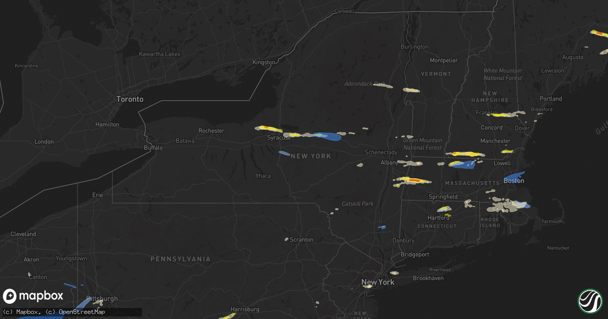
Hail Map in New York on June 30, 2021
Get this storm
June 30 map
$229
one time, instant access
Download today. No call, no setup
Keep the $229
Bought the map and want the full workflow? Apply the entire $229 to a subscription within 7 days. None of it is wasted.
Every map, not just this one
This buys you this map. Subscription and you get every map we run, in the markets you choose from a few cities to whole states to nationwide. Plus real-time alerts the moment a storm fires.
Contact data
Name, contact info, occupancy, even credit band for addresses in the footprint. You go from where it hit to who to call.
Become the source they trust
Unlimited branding weather history reports on demand. You already have the documented answer ready for the property owner, and you are the one who showed up with it.
Property data and RoofTrace estimates
Pull up any address you have got, its value and the exact code rules for that jurisdiction, straight from One Click Code. Then RoofTrace estimates the squares, pitch, and roof value, priced the way you price.
Storm reports in New York
New York
| Date | Description |
|---|---|
| 06/30/20216:15 PM CDT | Wallkill police reports numerous trees down. |
| 06/30/20216:03 PM CDT | Trees and wires down on south road and anthony drive |
| 06/30/20216:02 PM CDT | A local report indicates 58 MPH wind near HUDSON VALLEY REGION |
| 06/30/20215:58 PM CDT | Local officials estimated 50 trees down in a park in the vicinity of spring street and route 9d. |
| 06/30/20215:53 PM CDT | Large tree limb down on bloom street in marlboro |
| 06/30/20215:52 PM CDT | A severe thunderstorm produced microbursts near wappingers falls. Two main areas of damage were noted. The first was at bowdoin park along the hudson river where numero |
| 06/30/20215:45 PM CDT | Trees and wires down. Time estimated by radar. |
| 06/30/20215:07 PM CDT | Trees down. |
| 06/30/20215:05 PM CDT | Tree down on wires. Time estimated by radar. |
| 06/30/20214:40 PM CDT | Corrects previous tstm wnd dmg report from 2 wsw roxbury. Tree down across the road. Time estimated by radar. |
| 06/30/20213:40 PM CDT | Trees and wires down. |
| 06/30/20213:25 PM CDT | Trees and wires down. |
| 06/30/20213:03 PM CDT | Dispatch reports trees and powerlines down at hog hollow road intersection with payne marsh road. Time estimated. |
| 06/30/20212:40 PM CDT | A severe thunderstorm caused a series of microbursts between canaan... Ny and richmond... Ma between 340 pm and 350 pm. Damage began near the intersection of ny routes |
| 06/30/20212:39 PM CDT | Tree down across road. Time estimated by radar. |
| 06/30/20212:36 PM CDT | Tree and wires down along route 22 and miller rd. |
| 06/30/20212:36 PM CDT | Multiple trees and wires down on route 295 between route 22 and massachusetts line. Time estimated by radar. |
| 06/30/20212:36 PM CDT | Tree and wires down on lilly rd. Time estimated by radar. |
| 06/30/20212:33 PM CDT | Multiple trees down on tunnel hill rd. Time estimated by radar. |
| 06/30/20212:33 PM CDT | Tree down on road...route 295 and queechy lake dr. Time estimated from radar. |
| 06/30/20212:29 PM CDT | Trees and wires down across road. |
| 06/30/20212:23 PM CDT | Tree down across river road. |
| 06/30/20212:18 PM CDT | Trees and wires down. Time estimated by radar. |
| 06/30/20212:15 PM CDT | Trees and wires down. Time estimated by radar. |
| 06/30/20212:13 PM CDT | Tree down across the road. Time estimated by radar. |
| 06/30/20212:00 PM CDT | Large tree branches >2 inch diameter down. |
| 06/30/20211:49 PM CDT | Trees and wires down 0.5 mi south of ballard. Time estimated from radar. |
| 06/30/20211:49 PM CDT | Tree down across parking area. Time estimated by radar. |
| 06/30/20211:48 PM CDT | Tree and wires down. Time estimated by radar. |
| 06/30/20211:48 PM CDT | Trees and wires down on old post road |
| 06/30/20211:45 PM CDT | Mesonet station cw6427 apulia station. Davis vp2. Time from wxunderground 5 minute data. |
| 06/30/20211:45 PM CDT | Tree/pole down. Time estimated from radar |
| 06/30/20211:35 PM CDT | Multiple trees down. Report of no phone service throughout the town. |
| 06/30/20211:32 PM CDT | Tree down and crushed a fence. Time estimated by radar. |
| 06/30/20211:30 PM CDT | Multiple trees down along lake. Time estimated by radar. |
| 06/30/20211:30 PM CDT | Portion of a tree was snapped at the corner of pioneer street and harrower lane in the town of amsterdam |
| 06/30/20211:29 PM CDT | Tree down on mcdonald drive in fort johnson |
| 06/30/20211:23 PM CDT | Tree down blocking route 5 just west on winners circle restaurant. Time estimated from radar |
| 06/30/20211:22 PM CDT | Multiple trees down blocking road. Time estimated by radar. |
| 06/30/20211:20 PM CDT | Tree down through a house. Time estimated by radar. |
| 06/30/20211:18 PM CDT | Tree... Wires... And transformer down on military road. Time estimated based on radar |
| 06/30/20211:18 PM CDT | Tree down on a house near intersection of 5th ave and helwig st. |
| 06/30/20211:16 PM CDT | Trees and wires down. Time estimated by radar. |
| 06/30/20211:15 PM CDT | Tree down on road. Time estimated by radar. |
| 06/30/20211:13 PM CDT | Tree down across the road. Time estimated by radar. Time estimated by radar. |
| 06/30/202112:56 PM CDT | Tree on house on church st. |
| 06/30/202112:41 PM CDT | Trees and wires down. Time estimated by radar. |
| 06/30/202112:37 PM CDT | Trees and wires down. Time estimated by radar. |
| 06/30/202112:34 PM CDT | Trees and wires down. Time estimated by radar. |
| 06/30/202112:32 PM CDT | Trees and power lines down just north of the village on route 9 |
| 06/30/202112:28 PM CDT | Relayed report of window damage on the upper floors of the ny state office building in downtown utica. |
| 06/30/202112:26 PM CDT | A local report indicates 1.00 inch wind near 2 WSW UTICA |
| 06/30/202112:25 PM CDT | Multiple trees down on wires and roads across the city. Time estimated by radar. |
| 06/30/202112:23 PM CDT | Tree down on wires. Time estimated by radar. |
| 06/30/202112:23 PM CDT | Tree down on wires. Time estimated by radar. |
| 06/30/202112:23 PM CDT | Tree down on wires. Time estimated by radar. |
| 06/30/202112:22 PM CDT | Report from mping: quarter |
| 06/30/202112:17 PM CDT | Gutter pulled off house. Siding debris from nearby building laying on top of roof. Time estimated by radar. |
| 06/30/202112:10 PM CDT | Trees and power lines down on fowler ave |
| 06/30/202111:52 AM CDT | Large tree down on house and across road. Time estimated from radar. |
| 06/30/202111:01 AM CDT | Report from mping: quarter |
| 06/30/202110:42 AM CDT | Picture of almost golf ball sized hail on social media. Relayed via local broadcast media. |
| 06/30/20217:58 AM CDT | At 1257 PM EDT, a severe thunderstorm was located over Sherrill, or over Oneida, moving east at 30 mph. HAZARD...60 mph wind gusts and quarter size hail. SOURCE...Radar indicated. IMPACT...Hail damage to vehicles is expected. Expect wind damage to roofs, siding, and trees. Locations impacted include... Utica, Rome, Oneida, Kirkland, Lenox, Verona, Westmoreland, Paris, Deerfield and Whitesboro. |
| 06/30/20217:25 AM CDT | At 1224 AM EDT, a severe thunderstorm was located over Coopers Plains, or near Corning, moving northeast at 35 mph. HAZARD...60 mph wind gusts. SOURCE...Radar indicated. IMPACT...Expect damage to roofs, siding, and trees. Locations impacted include... Corning, Southport, Big Flats, Horseheads, Campbell, Caton, Painted Post, Addison, Hornby and Thurston. |
| 06/30/20217:19 AM CDT | At 1218 PM EDT, a severe thunderstorm was located over Bridgeport, or 10 miles northeast of Syracuse, moving east at 35 mph. HAZARD...60 mph wind gusts and quarter size hail. SOURCE...Radar indicated. IMPACT...Hail damage to vehicles is expected. Expect wind damage to roofs, siding, and trees. Locations impacted include... Sullivan, Oneida, Lenox, Verona, Chittenango, Canastota, Minoa, Sherrill, Stockbridge and Augusta. |
| 06/30/20216:34 AM CDT | At 1134 AM EDT, a severe thunderstorm was located over Lysander, or near Fulton, moving east at 25 mph. HAZARD...60 mph wind gusts and quarter size hail. SOURCE...Radar indicated. IMPACT...Hail damage to vehicles is expected. Expect wind damage to roofs, siding, and trees. Locations impacted include... Clay, Cicero, Lysander, Van Buren, Baldwinsville, North Syracuse, Liverpool, Bridgeport, Brewerton and Plainville. |
| 06/30/20216:30 AM CDT | At 1129 AM EDT, a severe thunderstorm was located over Cato, or 11 miles southeast of Fair Haven Beach State Park, moving east at 35 mph. HAZARD...60 mph wind gusts and quarter size hail. SOURCE...Radar indicated. IMPACT...Minor damage to vehicles is possible. Expect wind damage to roofs, siding, and trees. Locations impacted include... Fulton, Central Square, Cato, Constantia, West Monroe, Phoenix, Ira, Conquest, Meridian and South Hannibal. This includes Interstate 81 near exit 32. |
| 06/30/20214:24 AM CDT | At 923 PM EDT, a severe thunderstorm was located over Glen Cove, moving east at 30 mph. HAZARD...60 mph wind gusts and quarter size hail. SOURCE...Radar indicated. IMPACT...Minor hail damage to vehicles is possible. Expect wind damage to trees and power lines. This severe thunderstorm will be near... Plainview and Syosset around 935 PM EDT. Melville and Cold Spring Harbor around 940 PM EDT. Huntington Station and Huntington around 945 PM EDT. Northport and Dix Hills around 950 PM EDT. Commack around 955 PM EDT. Brentwood around 1000 PM EDT. Hauppauge and Smithtown around 1005 PM EDT. Ronkonkoma and Stony Brook around 1010 PM EDT. Centereach and Port Jefferson around 1015 PM EDT.This includes the following New York State COVID tent site SUNY Stony Brook. |
| 06/30/20213:37 AM CDT | At 837 PM EDT, a severe thunderstorm was located near Bayville, or near Oyster Bay, moving east at 25 mph. HAZARD...60 mph wind gusts and penny size hail. SOURCE...Radar indicated. IMPACT...Expect damage to trees and power lines. This severe thunderstorm will be near... Huntington around 850 PM EDT. Northport and Centerport around 855 PM EDT. Stony Brook around 915 PM EDT.This includes the following New York State COVID tent site SUNY Stony Brook. |
| 06/30/20212:12 AM CDT | At 712 PM EDT, a severe thunderstorm was located near Montgomery, or near Walden, moving northeast at 35 mph. HAZARD...60 mph wind gusts and penny size hail. SOURCE...Radar indicated. IMPACT...Expect damage to trees and power lines. This severe thunderstorm will be near... Montgomery around 715 PM EDT. Walden around 725 PM EDT. New Windsor and Gardnertown around 730 PM EDT. Newburgh around 735 PM EDT. |
| 06/30/20211:34 AM CDT | At 634 PM EDT, a severe thunderstorm was located over Marlboro, or 7 miles southwest of Poughkeepsie, moving east at 45 mph. HAZARD...60 mph wind gusts and penny size hail. SOURCE...Radar indicated. IMPACT...Expect damage to roofs, siding, and trees. Locations impacted include... Poughkeepsie, Wappingers Falls, Highland, Hopewell Junction, Marlboro, Red Oaks Mill, Myers Corner, Wingdale, Dover Plains, Beekman, Tuckers Corner, Knapps Corner, South Dover, Hoxie Corner, New Hamburg, Clove Valley, South Amenia, Poughquag, Billings and Pleasant Ridge. |
| 06/30/20211:32 AM CDT | At 631 PM EDT, a severe thunderstorm was located near Grahamsville, or 10 miles northeast of Liberty, moving east at 50 mph. HAZARD...60 mph wind gusts. SOURCE...Radar indicated. IMPACT...Expect damage to roofs, siding, and trees. Locations impacted include... Woodstock, West Shokan, Kenneth L Wilson Campground, Olivebridge, West Hurley, Denning, Ashokan, Cherrytown, Samsonville, Glenford, Palentown, Atwood, Sundown, Pacama, Brodhead, Liebhardt, Fantinekill, Montoma, Branch and Mombaccus. |
| 06/30/20211:26 AM CDT | At 626 PM EDT, a severe thunderstorm was located over Willowemoc, or 7 miles northeast of Liberty, moving east at 45 mph. HAZARD...70 mph wind gusts and quarter size hail. SOURCE...Radar indicated. IMPACT...Hail damage to vehicles is expected. Expect considerable tree damage. Wind damage is also likely to mobile homes, roofs, and outbuildings. Locations impacted include... Liberty, Neversink, Jeffersonville, White Sulphur Springs, Parksville, Hazel, Livingston Manor, Grahamsville, Willowemoc and Bradley. |
| 06/30/202112:34 AM CDT | At 534 PM EDT, a severe thunderstorm was located near Philmont, or near Chatham, moving east at 30 mph. HAZARD...60 mph wind gusts and quarter size hail. SOURCE...Radar indicated. IMPACT...Hail damage to vehicles is expected. Expect wind damage to roofs, siding, and trees. Locations impacted include... Great Barrington, Chatham, Lee, Lenox, Becket, Austerlitz, Otis, Philmont, Housatonic, Ghent, Stockbridge, Richmond, West Stockbridge, Monterey, Washington, Alford, Tyringham, Glendale, North Hillsdale and Williamsville. |
| 06/29/202111:50 PM CDT | At 448 PM EDT, severe thunderstorms were located along a line extending from near Guilford to near Brackney to near Litchfield to Wetona, moving southeast at 20 mph. HAZARD...60 mph wind gusts and quarter size hail. SOURCE...Radar indicated. IMPACT...Hail damage to vehicles is expected. Expect wind damage to roofs, siding, and trees. Locations impacted include... Chemung, Binghamton, Vestal, Johnson City, Endicott, Kirkwood, Sayre, Conklin, Waverly and Sidney. |
| 06/29/202111:47 PM CDT | At 447 PM EDT, a severe thunderstorm was located near Breakabeen, or 7 miles south of Cobleskill, moving east at 30 mph. HAZARD...60 mph wind gusts and penny size hail. SOURCE...Radar indicated. IMPACT...Expect damage to roofs, siding, and trees. Locations impacted include... Westerlo, Berne, Middleburgh, Livingstonville, Breakabeen, Rensselaerville, East Berne, Shoefelt Corners, West Berne, Huntersland, Smith Corner, West Fulton, Vintonton, Bramans Corners, Helderberg, Eminence, Lambs Corner, Housons Corners, Zucks Corners and Snyders Corners. |
| 06/29/202111:12 PM CDT | At 411 PM EDT, a severe thunderstorm was located near Hartwick, or 12 miles west of Cooperstown, moving east at 25 mph. HAZARD...60 mph wind gusts and quarter size hail. SOURCE...Radar indicated. IMPACT...Hail damage to vehicles is expected. Expect wind damage to roofs, siding, and trees. Locations impacted include... Norwich, Worcester, Middlefield, Hartwick, Maryland, Cooperstown, Edmeston, Westville, North Norwich and Pittsfield. |
| 06/29/202110:28 PM CDT | At 328 PM EDT, severe thunderstorms were located along a line extending from De Ruyter to near Ithaca to near Big Flats, moving east at 45 mph. HAZARD...60 mph wind gusts and quarter size hail. SOURCE...Radar indicated. IMPACT...Hail damage to vehicles is expected. Expect wind damage to roofs, siding, and trees. Locations impacted include... Ithaca, Cortland, Norwich, Horseheads, Maine, Newfield, Owego, Cayuga Heights, Lansing and Danby. |
| 06/29/202110:08 PM CDT | At 308 PM EDT, a severe thunderstorm was located over Georgetown, or 10 miles west of Hamilton, moving east at 40 mph. HAZARD...60 mph wind gusts and quarter size hail. SOURCE...Radar indicated. IMPACT...Hail damage to vehicles is expected. Expect wind damage to roofs, siding, and trees. Locations impacted include... Eaton, Hamilton, Brookfield, Hartwick, Edmeston, Sherburne, Pittsfield, Lebanon, Burlington and New Lisbon. |
| 06/29/20219:25 PM CDT | At 225 PM EDT, severe thunderstorms were located along a line extending from near Canastota to Manlius to Otisco, moving east at 25 mph. HAZARD...60 mph wind gusts and quarter size hail. SOURCE...Radar indicated. IMPACT...Hail damage to vehicles is expected. Expect wind damage to roofs, siding, and trees. Locations impacted include... Sullivan, Oneida, Kirkland, Lenox, Pompey, Verona, Westmoreland, Eaton, Chittenango and Canastota. |
| 06/29/20219:18 PM CDT | At 218 PM EDT, severe thunderstorms were located along a line extending from near Edinburg to near Fonda, moving east at 50 mph. HAZARD...60 mph wind gusts. SOURCE...Radar indicated. IMPACT...Expect damage to roofs, siding, and trees. Locations impacted include... Saratoga Springs, Amsterdam, Gloversville, Johnstown, Fonda, Glenville, Ballston Spa, Corinth, Broadalbin, Hagaman, Edinburg, Northville, Mayfield, Round Lake, Fort Johnson, Galway, Cranberry Creek, Day Center, Northampton Beach Public Campground and Burnt Hills. |
| 06/29/20219:15 PM CDT | At 215 PM EDT, a severe thunderstorm was located over Honeoye, or 14 miles southwest of Canandaigua, moving east at 25 mph. HAZARD...60 mph wind gusts and quarter size hail. SOURCE...Radar indicated. IMPACT...Minor damage to vehicles is possible. Expect wind damage to roofs, siding, and trees. Locations impacted include... Geneva, Canandaigua, Bristol, Lima, Clifton Springs, Phelps, Bloomfield, Rushville, Honeoye and Hemlock. This includes Interstate 90 near exit 42. |
| 06/29/20219:07 PM CDT | At 206 PM EDT, a severe thunderstorm was located near Waterloo, moving east at 35 mph. HAZARD...60 mph wind gusts and quarter size hail. SOURCE...Radar indicated. IMPACT...Hail damage to vehicles is expected. Expect wind damage to roofs, siding, and trees. Locations impacted include... Auburn, Seneca Falls, Waterloo, Owasco, Sennett, Fleming, Montezuma, Union Springs, Tyre and Cayuga. |
| 06/29/20219:04 PM CDT | Nypd reports wires down in lower manhattan. |
| 06/29/20218:41 PM CDT | At 141 PM EDT, a severe thunderstorm was located over Dolgeville, or near Little Falls, moving east at 45 mph. HAZARD...60 mph wind gusts and quarter size hail. SOURCE...Radar indicated. IMPACT...Hail damage to vehicles is expected. Expect wind damage to roofs, siding, and trees. Locations impacted include... Gloversville, Johnstown, Little Falls, Dolgeville, Broadalbin, Northville, Mayfield, Stratford, Cranberry Creek, Caroga Lake Public Campground, Northampton Beach Public Campground, Caroga Lake, Oppenheim, Berkshire, Bleecker, Ingham Mills, Meco, Munsonville, Curtis and Sweets Crossing. |
| 06/29/20218:30 PM CDT | Glen cove reports numerous trees down across the area. |
| 06/29/20218:22 PM CDT | At 122 PM EDT, a severe thunderstorm was located over Yorkville, or over Utica, moving east at 45 mph. HAZARD...60 mph wind gusts and quarter size hail. SOURCE...Radar indicated. IMPACT...Hail damage to vehicles is expected. Expect wind damage to roofs, siding, and trees. Locations impacted include... Ilion, Herkimer, Little Falls, Mohawk, Frankfort, Dolgeville, Newport, Middleville, Fairfield, Elizabethtown, Ingham Mills, Jersalem Hill, West Frankfort, Spinnerville, Corrado Corners, Curtis, Farrel Corner, Countryman, North Ilion and Gulph. |
All States Impacted by Hail Map on June 30, 2021
Cities Impacted by Hail Map on June 30, 2021
- Orwell, VT
- Brandon, VT
- Lawrenceville, IL
- Waterbury, VT
- Williston, VT
- Shelburne, VT
- South Burlington, VT
- Richmond, VT
- Carlisle, PA
- Boiling Springs, PA
- Eclectic, AL
- Grafton, MA
- Holliston, MA
- Milford, MA
- Upton, MA
- South Grafton, MA
- Northbridge, MA
- Hopkinton, MA
- Sedgwick, ME
- Blue Hill, ME
- Sargentville, ME
- Brooksville, ME
- Harborside, ME
- Brooklin, ME
- Pittsfield, MA
- Richmond, MA
- Mitchell, OR
- Grand Marais, MN
- Tennyson, IN
- Wallace, MI
- Menominee, MI
- Raynham, MA
- South Easton, MA
- Wendell, MA
- Royalston, MA
- Athol, MA
- Orange, MA
- Northfield, MA
- Erving, MA
- Warwick, MA
- Enoree, SC
- Burlington, WV
- Purgitsville, WV
- Dixmont, ME
- Brooks, ME
- Troy, ME
- Monroe, ME
- Dolgeville, NY
- Johnstown, NY
- Caroga Lake, NY
- Saint Johnsville, NY
- Bridgewater, MA
- West Bridgewater, MA
- Halifax, MA
- Middleboro, MA
- Plympton, MA
- Zalma, MO
- Patton, MO
- Jaffrey, NH
- New Ipswich, NH
- Rindge, NH
- Mathias, WV
- Greenleaf, WI
- North Dighton, MA
- Rehoboth, MA
- East Taunton, MA
- Taunton, MA
- Windham, NH
- Chatham, NY
- Ghent, NY
- Elizabethport, NJ
- Elizabeth, NJ
- Staten Island, NY
- Linden, NJ
- Lenox, MA
- Baldwinville, MA
- Gardner, MA
- Winchendon, MA
- Hedgesville, WV
- Gerrardstown, WV
- Kirkville, NY
- Chittenango, NY
- Oneida, NY
- Canastota, NY
- Wampsville, NY
- Ellington, CT
- East Windsor, CT
- Broad Brook, CT
- Windsor Locks, CT
- Windsor, CT
- Athens, OH
- Putnam Station, NY
- Mansfield, MA
- Pittsford, VT
- Chittenden, VT
- Killington, VT
- Stockbridge, VT
- Pittsfield, VT
- Marble Hill, MO
- Glenallen, MO
- Searsmont, ME
- Morrill, ME
- Belfast, ME
- Lincolnville, ME
- Woodstock, CT
- Woodstock Valley, CT
- Baldwinsville, NY
- Broadway, VA
- Waynesburg, KY
- Jacobsburg, OH
- Bellaire, OH
- Saint Clairsville, OH
- Neffs, OH
- Liverpool, NY
- Clay, NY
- Cato, NY
- Fulton, NY
- Phoenix, NY
- Surry, ME
- Penobscot, ME
- Bucksport, ME
- Orland, ME
- Lee, MA
- Becket, MA
- Adams, MA
- North Attleboro, MA
- Attleboro, MA
- Norton, MA
- Peterborough, NH
- Berwick, ME
- Crown King, AZ
- Xenia, IL
- Louisville, IL
- Flora, IL
- Winchester, VA
- Cross Junction, VA
- New Hartford, NY
- Utica, NY
- New York Mills, NY
- Yorkville, NY
- Whitesboro, NY
- Clinton, NY
- Hermansville, MI
- Winterport, ME
- Stockton Springs, ME
- Burnham, ME
- Frankfort, ME
- Metropolis, IL
- Smithfield, RI
- Pawtucket, RI
- Central Falls, RI
- Lincoln, RI
- Providence, RI
- Cumberland, RI
- Newville, PA
- Sea Cliff, NY
- Glen Cove, NY
- Port Washington, NY
- Glen Head, NY
- Mayfield, NY
- Stephentown, NY
- Sand Lake, NY
- Lanesborough, MA
- Savoy, MA
- Poestenkill, NY
- Berlin, NY
- Williamstown, MA
- North Adams, MA
- Averill Park, NY
- Petersburg, NY
- East Bridgewater, MA
- North Easton, MA
- Eubank, KY
- Riggins, ID
- Tilton, NH
- Gilmanton, NH
- Center Barnstead, NH
- Milton, NH
- Loudon, NH
- Lebanon, ME
- Barnstead, NH
- Union, NH
- Alton, NH
- Belmont, NH
- Farmington, NH
- Springvale, ME
- New Durham, NH
- Sanford, ME
- Canterbury, NH
- Gilmanton Iron Works, NH
- Wells, ME
- McDonald, PA
- Presto, PA
- Oakdale, PA
- Pittsburgh, PA
- Carnegie, PA
- Cuddy, PA
- Morgan, PA
- Bridgeville, PA
- Bethel Park, PA
- Albany, OH
- New Marshfield, OH
- West Stockbridge, MA
- East Chatham, NY
- Canaan, NY
- Gwinn, MI
- Rock, MI
- Needmore, PA
- Warfordsburg, PA
- Winchester, NH
- Swanzey, NH
- Lenox Dale, MA
- Hinsdale, MA
- Grayson, KY
- Caldwell, OH
- Adrian, TX
- Schuylerville, NY
- Franklin, MA
- Rapid River, MI
- Gladstone, MI
- Perkins, MI
- Ballston Spa, NY
- Burnt Hills, NY
- Ballston Lake, NY
- Bluemont, VA
- Upperville, VA
- Paris, VA
- Poughkeepsie, NY
- Wappingers Falls, NY
- Seal Cove, ME
- Southwest Harbor, ME
- Bernard, ME
- Castine, ME
- Schroon Lake, NY
- Minerva, NY
- Olmstedville, NY
- Ashburnham, MA
- Sherman, ME
- Brillion, WI
- Greenville, NH
- Arlington, VT
- Shushan, NY
- Cambridge, NY
- Wilton, NH
- Troy, NH
- Brookline, NH
- Temple, NH
- Fitzwilliam, NH
- Lovettsville, VA
- Leesburg, VA
- Zanesville, OH
- Adamsville, OH
- Capon Bridge, WV
- Augusta, WV
- Mendon, MA
- Wrentham, MA
- Blackstone, MA
- Bellingham, MA
- Plainville, MA
- Point Of Rocks, MD
- Waterford, VA
- Tuscarora, MD
- Purcellville, VA
- Round Hill, VA
- Harpers Ferry, WV
- McArthur, OH
- Clark Mills, NY
- Harveys Lake, PA
- Tunkhannock, PA
- Noxen, PA
- Dallas, PA
- Martinsville, NJ
- Greenfield, MA
- Shelburne Falls, MA
- Colrain, MA
- Albion, ME
- South China, ME
- Middlefield, MA
- Chester, MA
- Vulcan, MI
- Carney, MI
- Vernon, NY
- Minoa, NY
- Westmoreland, NY
- Vernon Center, NY
- Sherrill, NY
- Frankfort, NY
- East Syracuse, NY
- Fayetteville, NY
- Verona, NY
- Brattleboro, VT
- Haverhill, MA
- Atkinson, NH
- Salem, NH
- Plaistow, NH
- Petersburg, IN
- Washington, IN
- Thompson, CT
- North Grosvenordale, CT
- Kings Mountain, KY
- Huntington, MA
- Sandown, NH
- Chester, NH
- West Townsend, MA
- Ashby, MA
- Shippensburg, PA
- Mount Holly Springs, PA
- Greenwich, NY
- West Paducah, KY
- Seekonk, MA
- Oconto, WI
- Ashuelot, NH
- Vernon, VT
- Hinsdale, NH
- Crystal Spring, PA
- Breezewood, PA
- Natural Bridge Station, VA
- Green Spring, WV
- Kaukauna, WI
- Tallassee, AL
- Livingston Manor, NY
- Roscoe, NY
- Stafford Springs, CT
- Southbridge, MA
- Eastford, CT
- Souderton, PA
- McConnellsburg, PA
- Harrisonville, PA
- Barnesville, OH
- Quaker City, OH
- Canonsburg, PA
- Venetia, PA
- Senecaville, OH
- Ticonderoga, NY
- Kennebunkport, ME
- Fultonham, NY
- Schoharie, NY
- Warnerville, NY
- Middleburgh, NY
- Perkasie, PA
- Sellersville, PA
- Ellsworth, ME
- Foxboro, MA
- Boyce, VA
- Front Royal, VA
- White Post, VA
- Fremont Center, NY
- North Branch, NY
- Callicoon, NY
- Nashport, OH
- Chillicothe, OH
- Laurelville, OH
- Valatie, NY
- Chesterfield, MA
- Hillsdale, NY
- Austerlitz, NY
- Old Chatham, NY
- Stockbridge, MA
- Spencertown, NY
- West Chesterfield, MA
- Worthington, MA
- Kinderhook, NY
- Gore, VA
- Little Falls, NY
- Walnut Bottom, PA
- Oyster Bay, NY
- Locust Valley, NY
- Glenwood Landing, NY
- Clark, NJ
- Bayonne, NJ
- Garwood, NJ
- Cranford, NJ
- Westfield, NJ
- Rahway, NJ
- Roselle, NJ
- Franklin, NH
- Benwood, WV
- Wheeling, WV
- North Lawrence, OH
- Massillon, OH
- Canal Fulton, OH
- Chepachet, RI
- Berkley, MA
- Woonsocket, RI
- Attleboro Falls, MA
- Manville, RI
- Johnston, RI
- North Scituate, RI
- Greenville, RI
- Sharon, MA
- North Providence, RI
- Albion, RI
- North Smithfield, RI
- Kingston, MA
- South Windsor, CT
- Bloomfield, CT
- Tolland, CT
- Stephenson, MI
- Red Creek, NY
- Syracuse, NY
- Martville, NY
- Cicero, NY
- Detroit, ME
- Mechanicsburg, PA
- Dresden, OH
- Old Washington, OH
- New Concord, OH
- Cambridge, OH
- Kipling, OH
- Adena, OH
- Dillonvale, OH
- Kimbolton, OH
- Piedmont, OH
- Salesville, OH
- Mount Pleasant, OH
- Norwich, OH
- Byesville, OH
- Morristown, OH
- Bethesda, OH
- Flushing, OH
- Rayland, OH
- Freeport, OH
- Belmont, OH
- Lore City, OH
- Cadiz, OH
- Avella, PA
- Coraopolis, PA
- Bulger, PA
- Langeloth, PA
- Imperial, PA
- Burgettstown, PA
- Colliers, WV
- Wellsburg, WV
- Joffre, PA
- Bethany, WV
- Atlasburg, PA
- Midway, PA
- Slovan, PA
- Chester, WV
- Lisbon, OH
- Wellsville, OH
- East Liverpool, OH
- Salineville, OH
- Industry, PA
- Ilion, NY
- Herkimer, NY
- Mohawk, NY
- Marcy, NY
- Truxton, NY
- Apulia Station, NY
- La Fayette, NY
- Tully, NY
- Fabius, NY
- De Ruyter, NY
- Marlboro, NY
- Ponca City, OK
- Blackwell, OK
- Escanaba, MI
- Wells, MI
- Templeton, MA
- Westminster, MA
- Wendell Depot, MA
- Revere, MA
- Stoneham, MA
- Swampscott, MA
- Marblehead, MA
- Somerville, MA
- Nahant, MA
- Belmont, MA
- Lexington, MA
- West Newton, MA
- Charlestown, MA
- Winchester, MA
- Waltham, MA
- Winthrop, MA
- Malden, MA
- Newtonville, MA
- Saugus, MA
- Allston, MA
- East Boston, MA
- Watertown, MA
- Chelsea, MA
- Everett, MA
- Cambridge, MA
- Salem, MA
- Auburndale, MA
- Boston, MA
- Brighton, MA
- Lynn, MA
- Medford, MA
- Arlington, MA
- Melrose, MA
- Newton, MA
- South Boston, MA
- Plymouth, MA
- Carver, MA
- Newton, NH
- Derry, NH
- Manchester, CT
- Vernon Rockville, CT
- Bolton, CT


