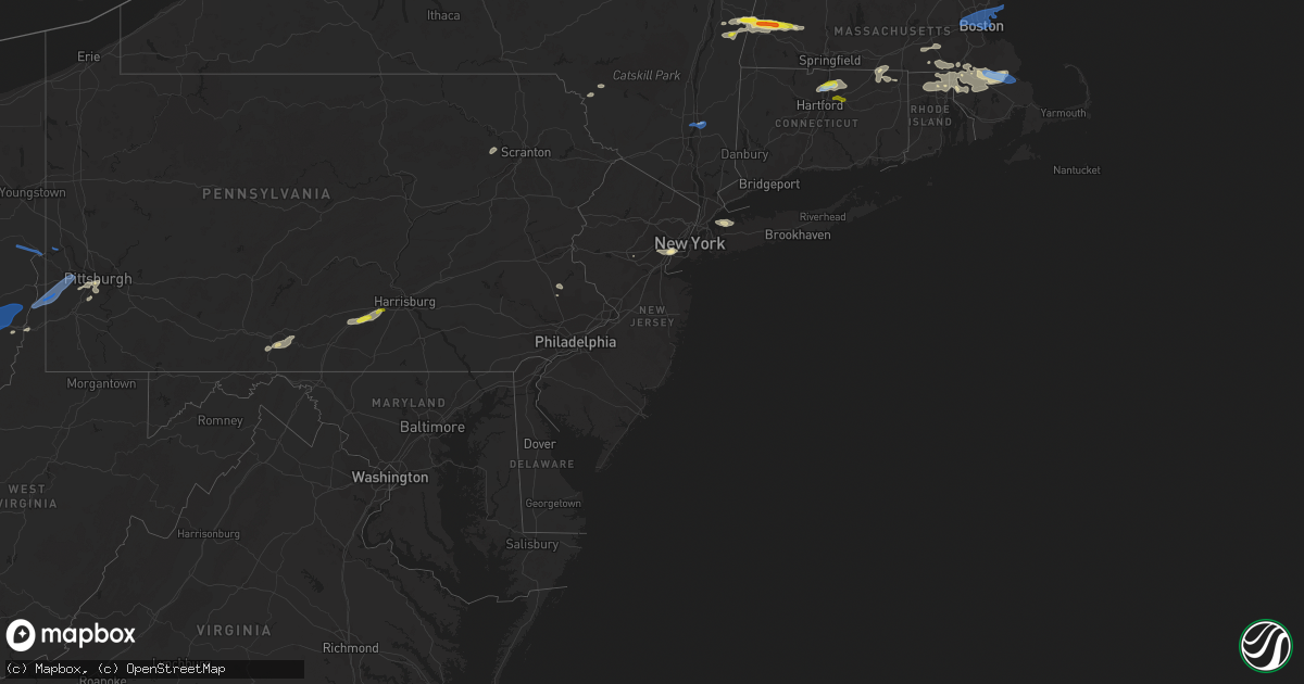
Hail Map in New Jersey on June 30, 2021
Get this storm
June 30 map
$229
one time, instant access
Download today. No call, no setup
Keep the $229
Bought the map and want the full workflow? Apply the entire $229 to a subscription within 7 days. None of it is wasted.
Every map, not just this one
This buys you this map. Subscription and you get every map we run, in the markets you choose from a few cities to whole states to nationwide. Plus real-time alerts the moment a storm fires.
Contact data
Name, contact info, occupancy, even credit band for addresses in the footprint. You go from where it hit to who to call.
Become the source they trust
Unlimited branding weather history reports on demand. You already have the documented answer ready for the property owner, and you are the one who showed up with it.
Property data and RoofTrace estimates
Pull up any address you have got, its value and the exact code rules for that jurisdiction, straight from One Click Code. Then RoofTrace estimates the squares, pitch, and roof value, priced the way you price.
Storm reports in New Jersey
New Jersey
| Date | Description |
|---|---|
| 06/30/20214:39 AM CDT | At 938 PM EDT, severe thunderstorms were located along a line extending from SoHo to near Sayreville, moving east at 35 mph. HAZARD...60 mph wind gusts and quarter size hail. SOURCE...Radar indicated. IMPACT...Minor hail damage to vehicles is possible. Expect wind damage to trees and power lines. Locations impacted include... Newark, Jersey City, Jamaica, Elizabeth, Flatbush, Bayonne, Hoboken, Freeport, Linden, Valley Stream, Long Beach, Coney Island, Lynbrook, Woodmere and Harrison.This includes the following New York State COVID tent sites Aqueduct Racetrack...Staten Island OMH...and Beverly Road in Brooklyn. |
| 06/30/20213:37 AM CDT | At 837 PM EDT, a severe thunderstorm was located over Dublin, or 20 miles southeast of Allentown, moving east at 30 mph. HAZARD...60 mph wind gusts. SOURCE...Radar indicated. IMPACT...Damage to roofs, siding, trees, and power lines is possible. Locations impacted include... Ewing, Perkasie, Doylestown, Byram, Bedminster, Flemington, Chalfont, Tinicum, New Hope, Dublin, Stockton, Washington Crossing, Fricks, Lumberville, Ottsville, Sergeantsville, Pipersville, Gardenville, Sand Brook and Erwinna.This includes Interstate 295 in New Jersey between mile markers 73and 76. |
| 06/29/20218:46 PM CDT | Downed tree on state highway 18 north of ferry road. All northbound lanes closed. Time estimated from radar. |
| 06/29/20218:44 PM CDT | Downed tree on state highway 34 near newman springs road... Likely from outflow winds from weakening storms. Several reports of power outages in the area as well. Time |
| 06/29/20218:35 PM CDT | Several reports of downed trees and wires near englishtown and north of freehold... Likely from outflow winds from weakening storms. Time estimated from radar. |
All States Impacted by Hail Map on June 30, 2021
Cities Impacted by Hail Map on June 30, 2021
- Orwell, VT
- Brandon, VT
- Lawrenceville, IL
- Waterbury, VT
- Williston, VT
- Shelburne, VT
- South Burlington, VT
- Richmond, VT
- Carlisle, PA
- Boiling Springs, PA
- Eclectic, AL
- Grafton, MA
- Holliston, MA
- Milford, MA
- Upton, MA
- South Grafton, MA
- Northbridge, MA
- Hopkinton, MA
- Sedgwick, ME
- Blue Hill, ME
- Sargentville, ME
- Brooksville, ME
- Harborside, ME
- Brooklin, ME
- Pittsfield, MA
- Richmond, MA
- Mitchell, OR
- Grand Marais, MN
- Tennyson, IN
- Wallace, MI
- Menominee, MI
- Raynham, MA
- South Easton, MA
- Wendell, MA
- Royalston, MA
- Athol, MA
- Orange, MA
- Northfield, MA
- Erving, MA
- Warwick, MA
- Enoree, SC
- Burlington, WV
- Purgitsville, WV
- Dixmont, ME
- Brooks, ME
- Troy, ME
- Monroe, ME
- Dolgeville, NY
- Johnstown, NY
- Caroga Lake, NY
- Saint Johnsville, NY
- Bridgewater, MA
- West Bridgewater, MA
- Halifax, MA
- Middleboro, MA
- Plympton, MA
- Zalma, MO
- Patton, MO
- Jaffrey, NH
- New Ipswich, NH
- Rindge, NH
- Mathias, WV
- Greenleaf, WI
- North Dighton, MA
- Rehoboth, MA
- East Taunton, MA
- Taunton, MA
- Windham, NH
- Chatham, NY
- Ghent, NY
- Elizabethport, NJ
- Elizabeth, NJ
- Staten Island, NY
- Linden, NJ
- Lenox, MA
- Baldwinville, MA
- Gardner, MA
- Winchendon, MA
- Hedgesville, WV
- Gerrardstown, WV
- Kirkville, NY
- Chittenango, NY
- Oneida, NY
- Canastota, NY
- Wampsville, NY
- Ellington, CT
- East Windsor, CT
- Broad Brook, CT
- Windsor Locks, CT
- Windsor, CT
- Athens, OH
- Putnam Station, NY
- Mansfield, MA
- Pittsford, VT
- Chittenden, VT
- Killington, VT
- Stockbridge, VT
- Pittsfield, VT
- Marble Hill, MO
- Glenallen, MO
- Searsmont, ME
- Morrill, ME
- Belfast, ME
- Lincolnville, ME
- Woodstock, CT
- Woodstock Valley, CT
- Baldwinsville, NY
- Broadway, VA
- Waynesburg, KY
- Jacobsburg, OH
- Bellaire, OH
- Saint Clairsville, OH
- Neffs, OH
- Liverpool, NY
- Clay, NY
- Cato, NY
- Fulton, NY
- Phoenix, NY
- Surry, ME
- Penobscot, ME
- Bucksport, ME
- Orland, ME
- Lee, MA
- Becket, MA
- Adams, MA
- North Attleboro, MA
- Attleboro, MA
- Norton, MA
- Peterborough, NH
- Berwick, ME
- Crown King, AZ
- Xenia, IL
- Louisville, IL
- Flora, IL
- Winchester, VA
- Cross Junction, VA
- New Hartford, NY
- Utica, NY
- New York Mills, NY
- Yorkville, NY
- Whitesboro, NY
- Clinton, NY
- Hermansville, MI
- Winterport, ME
- Stockton Springs, ME
- Burnham, ME
- Frankfort, ME
- Metropolis, IL
- Smithfield, RI
- Pawtucket, RI
- Central Falls, RI
- Lincoln, RI
- Providence, RI
- Cumberland, RI
- Newville, PA
- Sea Cliff, NY
- Glen Cove, NY
- Port Washington, NY
- Glen Head, NY
- Mayfield, NY
- Stephentown, NY
- Sand Lake, NY
- Lanesborough, MA
- Savoy, MA
- Poestenkill, NY
- Berlin, NY
- Williamstown, MA
- North Adams, MA
- Averill Park, NY
- Petersburg, NY
- East Bridgewater, MA
- North Easton, MA
- Eubank, KY
- Riggins, ID
- Tilton, NH
- Gilmanton, NH
- Center Barnstead, NH
- Milton, NH
- Loudon, NH
- Lebanon, ME
- Barnstead, NH
- Union, NH
- Alton, NH
- Belmont, NH
- Farmington, NH
- Springvale, ME
- New Durham, NH
- Sanford, ME
- Canterbury, NH
- Gilmanton Iron Works, NH
- Wells, ME
- McDonald, PA
- Presto, PA
- Oakdale, PA
- Pittsburgh, PA
- Carnegie, PA
- Cuddy, PA
- Morgan, PA
- Bridgeville, PA
- Bethel Park, PA
- Albany, OH
- New Marshfield, OH
- West Stockbridge, MA
- East Chatham, NY
- Canaan, NY
- Gwinn, MI
- Rock, MI
- Needmore, PA
- Warfordsburg, PA
- Winchester, NH
- Swanzey, NH
- Lenox Dale, MA
- Hinsdale, MA
- Grayson, KY
- Caldwell, OH
- Adrian, TX
- Schuylerville, NY
- Franklin, MA
- Rapid River, MI
- Gladstone, MI
- Perkins, MI
- Ballston Spa, NY
- Burnt Hills, NY
- Ballston Lake, NY
- Bluemont, VA
- Upperville, VA
- Paris, VA
- Poughkeepsie, NY
- Wappingers Falls, NY
- Seal Cove, ME
- Southwest Harbor, ME
- Bernard, ME
- Castine, ME
- Schroon Lake, NY
- Minerva, NY
- Olmstedville, NY
- Ashburnham, MA
- Sherman, ME
- Brillion, WI
- Greenville, NH
- Arlington, VT
- Shushan, NY
- Cambridge, NY
- Wilton, NH
- Troy, NH
- Brookline, NH
- Temple, NH
- Fitzwilliam, NH
- Lovettsville, VA
- Leesburg, VA
- Zanesville, OH
- Adamsville, OH
- Capon Bridge, WV
- Augusta, WV
- Mendon, MA
- Wrentham, MA
- Blackstone, MA
- Bellingham, MA
- Plainville, MA
- Point Of Rocks, MD
- Waterford, VA
- Tuscarora, MD
- Purcellville, VA
- Round Hill, VA
- Harpers Ferry, WV
- McArthur, OH
- Clark Mills, NY
- Harveys Lake, PA
- Tunkhannock, PA
- Noxen, PA
- Dallas, PA
- Martinsville, NJ
- Greenfield, MA
- Shelburne Falls, MA
- Colrain, MA
- Albion, ME
- South China, ME
- Middlefield, MA
- Chester, MA
- Vulcan, MI
- Carney, MI
- Vernon, NY
- Minoa, NY
- Westmoreland, NY
- Vernon Center, NY
- Sherrill, NY
- Frankfort, NY
- East Syracuse, NY
- Fayetteville, NY
- Verona, NY
- Brattleboro, VT
- Haverhill, MA
- Atkinson, NH
- Salem, NH
- Plaistow, NH
- Petersburg, IN
- Washington, IN
- Thompson, CT
- North Grosvenordale, CT
- Kings Mountain, KY
- Huntington, MA
- Sandown, NH
- Chester, NH
- West Townsend, MA
- Ashby, MA
- Shippensburg, PA
- Mount Holly Springs, PA
- Greenwich, NY
- West Paducah, KY
- Seekonk, MA
- Oconto, WI
- Ashuelot, NH
- Vernon, VT
- Hinsdale, NH
- Crystal Spring, PA
- Breezewood, PA
- Natural Bridge Station, VA
- Green Spring, WV
- Kaukauna, WI
- Tallassee, AL
- Livingston Manor, NY
- Roscoe, NY
- Stafford Springs, CT
- Southbridge, MA
- Eastford, CT
- Souderton, PA
- McConnellsburg, PA
- Harrisonville, PA
- Barnesville, OH
- Quaker City, OH
- Canonsburg, PA
- Venetia, PA
- Senecaville, OH
- Ticonderoga, NY
- Kennebunkport, ME
- Fultonham, NY
- Schoharie, NY
- Warnerville, NY
- Middleburgh, NY
- Perkasie, PA
- Sellersville, PA
- Ellsworth, ME
- Foxboro, MA
- Boyce, VA
- Front Royal, VA
- White Post, VA
- Fremont Center, NY
- North Branch, NY
- Callicoon, NY
- Nashport, OH
- Chillicothe, OH
- Laurelville, OH
- Valatie, NY
- Chesterfield, MA
- Hillsdale, NY
- Austerlitz, NY
- Old Chatham, NY
- Stockbridge, MA
- Spencertown, NY
- West Chesterfield, MA
- Worthington, MA
- Kinderhook, NY
- Gore, VA
- Little Falls, NY
- Walnut Bottom, PA
- Oyster Bay, NY
- Locust Valley, NY
- Glenwood Landing, NY
- Clark, NJ
- Bayonne, NJ
- Garwood, NJ
- Cranford, NJ
- Westfield, NJ
- Rahway, NJ
- Roselle, NJ
- Franklin, NH
- Benwood, WV
- Wheeling, WV
- North Lawrence, OH
- Massillon, OH
- Canal Fulton, OH
- Chepachet, RI
- Berkley, MA
- Woonsocket, RI
- Attleboro Falls, MA
- Manville, RI
- Johnston, RI
- North Scituate, RI
- Greenville, RI
- Sharon, MA
- North Providence, RI
- Albion, RI
- North Smithfield, RI
- Kingston, MA
- South Windsor, CT
- Bloomfield, CT
- Tolland, CT
- Stephenson, MI
- Red Creek, NY
- Syracuse, NY
- Martville, NY
- Cicero, NY
- Detroit, ME
- Mechanicsburg, PA
- Dresden, OH
- Old Washington, OH
- New Concord, OH
- Cambridge, OH
- Kipling, OH
- Adena, OH
- Dillonvale, OH
- Kimbolton, OH
- Piedmont, OH
- Salesville, OH
- Mount Pleasant, OH
- Norwich, OH
- Byesville, OH
- Morristown, OH
- Bethesda, OH
- Flushing, OH
- Rayland, OH
- Freeport, OH
- Belmont, OH
- Lore City, OH
- Cadiz, OH
- Avella, PA
- Coraopolis, PA
- Bulger, PA
- Langeloth, PA
- Imperial, PA
- Burgettstown, PA
- Colliers, WV
- Wellsburg, WV
- Joffre, PA
- Bethany, WV
- Atlasburg, PA
- Midway, PA
- Slovan, PA
- Chester, WV
- Lisbon, OH
- Wellsville, OH
- East Liverpool, OH
- Salineville, OH
- Industry, PA
- Ilion, NY
- Herkimer, NY
- Mohawk, NY
- Marcy, NY
- Truxton, NY
- Apulia Station, NY
- La Fayette, NY
- Tully, NY
- Fabius, NY
- De Ruyter, NY
- Marlboro, NY
- Ponca City, OK
- Blackwell, OK
- Escanaba, MI
- Wells, MI
- Templeton, MA
- Westminster, MA
- Wendell Depot, MA
- Revere, MA
- Stoneham, MA
- Swampscott, MA
- Marblehead, MA
- Somerville, MA
- Nahant, MA
- Belmont, MA
- Lexington, MA
- West Newton, MA
- Charlestown, MA
- Winchester, MA
- Waltham, MA
- Winthrop, MA
- Malden, MA
- Newtonville, MA
- Saugus, MA
- Allston, MA
- East Boston, MA
- Watertown, MA
- Chelsea, MA
- Everett, MA
- Cambridge, MA
- Salem, MA
- Auburndale, MA
- Boston, MA
- Brighton, MA
- Lynn, MA
- Medford, MA
- Arlington, MA
- Melrose, MA
- Newton, MA
- South Boston, MA
- Plymouth, MA
- Carver, MA
- Newton, NH
- Derry, NH
- Manchester, CT
- Vernon Rockville, CT
- Bolton, CT


