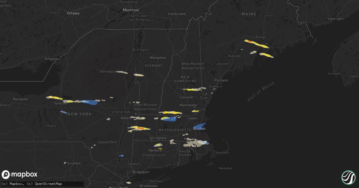
Hail Map in New Hampshire on June 30, 2021
Get this storm
June 30 map
$229
one time, instant access
Download today. No call, no setup
Keep the $229
Bought the map and want the full workflow? Apply the entire $229 to a subscription within 7 days. None of it is wasted.
Every map, not just this one
This buys you this map. Subscription and you get every map we run, in the markets you choose from a few cities to whole states to nationwide. Plus real-time alerts the moment a storm fires.
Contact data
Name, contact info, occupancy, even credit band for addresses in the footprint. You go from where it hit to who to call.
Become the source they trust
Unlimited branding weather history reports on demand. You already have the documented answer ready for the property owner, and you are the one who showed up with it.
Property data and RoofTrace estimates
Pull up any address you have got, its value and the exact code rules for that jurisdiction, straight from One Click Code. Then RoofTrace estimates the squares, pitch, and roof value, priced the way you price.
Storm reports in New Hampshire
New Hampshire
| Date | Description |
|---|---|
| 06/30/20214:45 PM CDT | Large tree down on longpond drive |
| 06/30/20214:30 PM CDT | Large tree fell on a house leaving it uninhabitable. Time estimated based on radar. |
| 06/30/20214:25 PM CDT | Multiple trees down along rte. 111 before i-93. |
| 06/30/20214:20 PM CDT | Multiple trees down. Time estimated from radar. |
| 06/30/20214:15 PM CDT | Corrects time of previous tstm wnd dmg report from 2 nw nashua. Large tree limb down on lutheran drive. Time estimated by radar. |
| 06/30/20214:14 PM CDT | Multiple trees down on broad street. Time estimated from radar. |
| 06/30/20214:01 PM CDT | Trees up to 2.5 inch in diameter down. No electricity. Time estimated based on radar. |
| 06/30/20213:58 PM CDT | A number of trees down along rt 130. Some 6 to 8 inch diameter trees snapped. Time estimated from radar. |
| 06/30/20213:53 PM CDT | Deputy chief of barnstead fire reports multiple instances of structural damage as a result of down trees. In addition... Multiple houses were struck by lightning and a |
| 06/30/20213:45 PM CDT | Multiple trees and wires down. Time estimated based on radar. |
| 06/30/20213:40 PM CDT | 1.50-2.00 inch hail which dented a vehicle. Time estimated by radar. |
| 06/30/20213:25 PM CDT | Tree on wires. Time estimated based on radar. |
| 06/30/20213:25 PM CDT | Multiple trees down. Time estimated from radar. |
| 06/30/20213:20 PM CDT | Down trees and wires completely blocking university drive. Time estimated based on radar. |
| 06/30/20213:20 PM CDT | Tree on wires with some burning. Time estimated based on radar. |
| 06/30/20213:18 PM CDT | Multiple trees down. Time estimated from radar. |
| 06/30/20213:15 PM CDT | Hail up to half dollar size... Which lasted for about 5 minutes. Some branches also came down across hwy 140. |
| 06/30/20213:15 PM CDT | Large tree limb down on lutheran drive. Time estimated by radar. |
| 06/30/20213:12 PM CDT | Multiple trees down. Time estimated from radar. |
| 06/30/20213:10 PM CDT | Hail up to ping pong ball size at camp forest lake. Lasted for about 5 minutes. Time estimated by radar. |
| 06/30/20213:05 PM CDT | Hail up to half dollar size along with winds up to around 50 mph. Time estimated by radar. |
| 06/30/20212:45 PM CDT | Trees down on waukeena lake rd west of danbury. Time estimated based on radar. |
| 06/30/20212:15 PM CDT | Tree knocked down in thunderstorm blocking streeter pond road. Pea size hail also reported. Time estimated by radar. |
| 06/30/20212:15 PM CDT | Country road closed for trees down. Time estimated based on radar. |
| 06/30/20212:12 PM CDT | 6-8 inch diameter tree snapped partially blocking road. Time estimated by radar. |
| 06/30/202112:25 AM CDT | At 525 PM EDT, a severe thunderstorm was located near Haverhill, moving east at 25 mph. HAZARD...60 mph wind gusts and quarter size hail. SOURCE...Radar indicated. IMPACT...Expect wind damage to trees and power lines. Minor hail damage to vehicles is possible. Locations impacted include... Lowell, Lawrence, Haverhill, Methuen, Chelmsford, Andover, Dracut, North Andover, Westford, Newburyport, Amesbury, Ipswich, Tyngsborough, Salisbury, Georgetown, Boxford, Newbury, Groveland, Merrimac and Rowley. |
| 06/29/202111:38 PM CDT | At 438 PM EDT, a severe thunderstorm was located over Farmington, or near Rochester, moving east at 50 mph. HAZARD...60 mph wind gusts and half dollar size hail. SOURCE...Radar indicated. IMPACT...Hail damage to vehicles is expected. Expect wind damage to roofs, siding, and trees. Locations impacted include... Rochester, Biddeford, Alfred, Sanford, Kennebunk, Berwick, Lebanon, Kennebunkport, Wells, South Berwick, York, Lyman, Arundel, Acton, Ogunquit, North Berwick, Milton and Shapleigh.This includes Interstate 95 between mile markers 13 and 30. This also includes... Ogunquit Beach, Wells Beach, and Fortunes Rock Beach. |
| 06/29/202110:49 PM CDT | At 348 PM EDT, severe thunderstorms were located along a line extending from near Londonderry to near West Wardsboro to Stamford, moving east at 45 mph. HAZARD...60 mph wind gusts. SOURCE...Radar indicated. IMPACT...Expect damage to roofs, siding, and trees. Locations impacted include... Brattleboro, Bellows Falls, Londonderry, Townshend, Stratton, Putney, Vernon, Wilmington, Readsboro, Saxtons River, Westminster, Newfane, Guilford Center, West Wardsboro, Windham, Rockingham, Guilford, Whitingham, Dover and Marlboro. |
| 06/29/202110:10 PM CDT | At 310 PM EDT, a severe thunderstorm was located over Franconia, or near Bethlehem, moving east at 40 mph. HAZARD...60 mph wind gusts. SOURCE...Radar indicated. IMPACT...Expect damage to roofs, siding, and trees. Locations impacted include... Littleton, Bethlehem, Lincoln, Franconia, Mount Washington, Carroll, Lisbon, Easton, Hart's Location, Sugar Hill, Landaff, Livermore and Whitefield.This includes Interstate 93 between mile markers 108 and 127. This also includes... Crawford Notch State Park, Franconia Notch, Cannon Mountain, NorthTwin Mountain, and Franconia Ridge. |
| 06/29/20219:24 PM CDT | At 223 PM EDT, a severe thunderstorm was located near Chittenden, moving east at 30 mph. HAZARD...60 mph wind gusts and half dollar size hail. SOURCE...Radar indicated. IMPACT...Minor hail damage to vehicles is possible. Expect wind damage to trees and powerlines. Locations impacted include... Woodstock, Rutland, White River Junction, Hartland Four Corners, Killington, Rutland City, Pomfret, Plymouth, Hartland, Chittenden, West Rutland, Barnard, Windsor, Woodstock Village, Quechee, Stockbridge, Proctor, Brandon, Bridgewater and Mendon. |
All States Impacted by Hail Map on June 30, 2021
Cities Impacted by Hail Map on June 30, 2021
- Orwell, VT
- Brandon, VT
- Lawrenceville, IL
- Waterbury, VT
- Williston, VT
- Shelburne, VT
- South Burlington, VT
- Richmond, VT
- Carlisle, PA
- Boiling Springs, PA
- Eclectic, AL
- Grafton, MA
- Holliston, MA
- Milford, MA
- Upton, MA
- South Grafton, MA
- Northbridge, MA
- Hopkinton, MA
- Sedgwick, ME
- Blue Hill, ME
- Sargentville, ME
- Brooksville, ME
- Harborside, ME
- Brooklin, ME
- Pittsfield, MA
- Richmond, MA
- Mitchell, OR
- Grand Marais, MN
- Tennyson, IN
- Wallace, MI
- Menominee, MI
- Raynham, MA
- South Easton, MA
- Wendell, MA
- Royalston, MA
- Athol, MA
- Orange, MA
- Northfield, MA
- Erving, MA
- Warwick, MA
- Enoree, SC
- Burlington, WV
- Purgitsville, WV
- Dixmont, ME
- Brooks, ME
- Troy, ME
- Monroe, ME
- Dolgeville, NY
- Johnstown, NY
- Caroga Lake, NY
- Saint Johnsville, NY
- Bridgewater, MA
- West Bridgewater, MA
- Halifax, MA
- Middleboro, MA
- Plympton, MA
- Zalma, MO
- Patton, MO
- Jaffrey, NH
- New Ipswich, NH
- Rindge, NH
- Mathias, WV
- Greenleaf, WI
- North Dighton, MA
- Rehoboth, MA
- East Taunton, MA
- Taunton, MA
- Windham, NH
- Chatham, NY
- Ghent, NY
- Elizabethport, NJ
- Elizabeth, NJ
- Staten Island, NY
- Linden, NJ
- Lenox, MA
- Baldwinville, MA
- Gardner, MA
- Winchendon, MA
- Hedgesville, WV
- Gerrardstown, WV
- Kirkville, NY
- Chittenango, NY
- Oneida, NY
- Canastota, NY
- Wampsville, NY
- Ellington, CT
- East Windsor, CT
- Broad Brook, CT
- Windsor Locks, CT
- Windsor, CT
- Athens, OH
- Putnam Station, NY
- Mansfield, MA
- Pittsford, VT
- Chittenden, VT
- Killington, VT
- Stockbridge, VT
- Pittsfield, VT
- Marble Hill, MO
- Glenallen, MO
- Searsmont, ME
- Morrill, ME
- Belfast, ME
- Lincolnville, ME
- Woodstock, CT
- Woodstock Valley, CT
- Baldwinsville, NY
- Broadway, VA
- Waynesburg, KY
- Jacobsburg, OH
- Bellaire, OH
- Saint Clairsville, OH
- Neffs, OH
- Liverpool, NY
- Clay, NY
- Cato, NY
- Fulton, NY
- Phoenix, NY
- Surry, ME
- Penobscot, ME
- Bucksport, ME
- Orland, ME
- Lee, MA
- Becket, MA
- Adams, MA
- North Attleboro, MA
- Attleboro, MA
- Norton, MA
- Peterborough, NH
- Berwick, ME
- Crown King, AZ
- Xenia, IL
- Louisville, IL
- Flora, IL
- Winchester, VA
- Cross Junction, VA
- New Hartford, NY
- Utica, NY
- New York Mills, NY
- Yorkville, NY
- Whitesboro, NY
- Clinton, NY
- Hermansville, MI
- Winterport, ME
- Stockton Springs, ME
- Burnham, ME
- Frankfort, ME
- Metropolis, IL
- Smithfield, RI
- Pawtucket, RI
- Central Falls, RI
- Lincoln, RI
- Providence, RI
- Cumberland, RI
- Newville, PA
- Sea Cliff, NY
- Glen Cove, NY
- Port Washington, NY
- Glen Head, NY
- Mayfield, NY
- Stephentown, NY
- Sand Lake, NY
- Lanesborough, MA
- Savoy, MA
- Poestenkill, NY
- Berlin, NY
- Williamstown, MA
- North Adams, MA
- Averill Park, NY
- Petersburg, NY
- East Bridgewater, MA
- North Easton, MA
- Eubank, KY
- Riggins, ID
- Tilton, NH
- Gilmanton, NH
- Center Barnstead, NH
- Milton, NH
- Loudon, NH
- Lebanon, ME
- Barnstead, NH
- Union, NH
- Alton, NH
- Belmont, NH
- Farmington, NH
- Springvale, ME
- New Durham, NH
- Sanford, ME
- Canterbury, NH
- Gilmanton Iron Works, NH
- Wells, ME
- McDonald, PA
- Presto, PA
- Oakdale, PA
- Pittsburgh, PA
- Carnegie, PA
- Cuddy, PA
- Morgan, PA
- Bridgeville, PA
- Bethel Park, PA
- Albany, OH
- New Marshfield, OH
- West Stockbridge, MA
- East Chatham, NY
- Canaan, NY
- Gwinn, MI
- Rock, MI
- Needmore, PA
- Warfordsburg, PA
- Winchester, NH
- Swanzey, NH
- Lenox Dale, MA
- Hinsdale, MA
- Grayson, KY
- Caldwell, OH
- Adrian, TX
- Schuylerville, NY
- Franklin, MA
- Rapid River, MI
- Gladstone, MI
- Perkins, MI
- Ballston Spa, NY
- Burnt Hills, NY
- Ballston Lake, NY
- Bluemont, VA
- Upperville, VA
- Paris, VA
- Poughkeepsie, NY
- Wappingers Falls, NY
- Seal Cove, ME
- Southwest Harbor, ME
- Bernard, ME
- Castine, ME
- Schroon Lake, NY
- Minerva, NY
- Olmstedville, NY
- Ashburnham, MA
- Sherman, ME
- Brillion, WI
- Greenville, NH
- Arlington, VT
- Shushan, NY
- Cambridge, NY
- Wilton, NH
- Troy, NH
- Brookline, NH
- Temple, NH
- Fitzwilliam, NH
- Lovettsville, VA
- Leesburg, VA
- Zanesville, OH
- Adamsville, OH
- Capon Bridge, WV
- Augusta, WV
- Mendon, MA
- Wrentham, MA
- Blackstone, MA
- Bellingham, MA
- Plainville, MA
- Point Of Rocks, MD
- Waterford, VA
- Tuscarora, MD
- Purcellville, VA
- Round Hill, VA
- Harpers Ferry, WV
- McArthur, OH
- Clark Mills, NY
- Harveys Lake, PA
- Tunkhannock, PA
- Noxen, PA
- Dallas, PA
- Martinsville, NJ
- Greenfield, MA
- Shelburne Falls, MA
- Colrain, MA
- Albion, ME
- South China, ME
- Middlefield, MA
- Chester, MA
- Vulcan, MI
- Carney, MI
- Vernon, NY
- Minoa, NY
- Westmoreland, NY
- Vernon Center, NY
- Sherrill, NY
- Frankfort, NY
- East Syracuse, NY
- Fayetteville, NY
- Verona, NY
- Brattleboro, VT
- Haverhill, MA
- Atkinson, NH
- Salem, NH
- Plaistow, NH
- Petersburg, IN
- Washington, IN
- Thompson, CT
- North Grosvenordale, CT
- Kings Mountain, KY
- Huntington, MA
- Sandown, NH
- Chester, NH
- West Townsend, MA
- Ashby, MA
- Shippensburg, PA
- Mount Holly Springs, PA
- Greenwich, NY
- West Paducah, KY
- Seekonk, MA
- Oconto, WI
- Ashuelot, NH
- Vernon, VT
- Hinsdale, NH
- Crystal Spring, PA
- Breezewood, PA
- Natural Bridge Station, VA
- Green Spring, WV
- Kaukauna, WI
- Tallassee, AL
- Livingston Manor, NY
- Roscoe, NY
- Stafford Springs, CT
- Southbridge, MA
- Eastford, CT
- Souderton, PA
- McConnellsburg, PA
- Harrisonville, PA
- Barnesville, OH
- Quaker City, OH
- Canonsburg, PA
- Venetia, PA
- Senecaville, OH
- Ticonderoga, NY
- Kennebunkport, ME
- Fultonham, NY
- Schoharie, NY
- Warnerville, NY
- Middleburgh, NY
- Perkasie, PA
- Sellersville, PA
- Ellsworth, ME
- Foxboro, MA
- Boyce, VA
- Front Royal, VA
- White Post, VA
- Fremont Center, NY
- North Branch, NY
- Callicoon, NY
- Nashport, OH
- Chillicothe, OH
- Laurelville, OH
- Valatie, NY
- Chesterfield, MA
- Hillsdale, NY
- Austerlitz, NY
- Old Chatham, NY
- Stockbridge, MA
- Spencertown, NY
- West Chesterfield, MA
- Worthington, MA
- Kinderhook, NY
- Gore, VA
- Little Falls, NY
- Walnut Bottom, PA
- Oyster Bay, NY
- Locust Valley, NY
- Glenwood Landing, NY
- Clark, NJ
- Bayonne, NJ
- Garwood, NJ
- Cranford, NJ
- Westfield, NJ
- Rahway, NJ
- Roselle, NJ
- Franklin, NH
- Benwood, WV
- Wheeling, WV
- North Lawrence, OH
- Massillon, OH
- Canal Fulton, OH
- Chepachet, RI
- Berkley, MA
- Woonsocket, RI
- Attleboro Falls, MA
- Manville, RI
- Johnston, RI
- North Scituate, RI
- Greenville, RI
- Sharon, MA
- North Providence, RI
- Albion, RI
- North Smithfield, RI
- Kingston, MA
- South Windsor, CT
- Bloomfield, CT
- Tolland, CT
- Stephenson, MI
- Red Creek, NY
- Syracuse, NY
- Martville, NY
- Cicero, NY
- Detroit, ME
- Mechanicsburg, PA
- Dresden, OH
- Old Washington, OH
- New Concord, OH
- Cambridge, OH
- Kipling, OH
- Adena, OH
- Dillonvale, OH
- Kimbolton, OH
- Piedmont, OH
- Salesville, OH
- Mount Pleasant, OH
- Norwich, OH
- Byesville, OH
- Morristown, OH
- Bethesda, OH
- Flushing, OH
- Rayland, OH
- Freeport, OH
- Belmont, OH
- Lore City, OH
- Cadiz, OH
- Avella, PA
- Coraopolis, PA
- Bulger, PA
- Langeloth, PA
- Imperial, PA
- Burgettstown, PA
- Colliers, WV
- Wellsburg, WV
- Joffre, PA
- Bethany, WV
- Atlasburg, PA
- Midway, PA
- Slovan, PA
- Chester, WV
- Lisbon, OH
- Wellsville, OH
- East Liverpool, OH
- Salineville, OH
- Industry, PA
- Ilion, NY
- Herkimer, NY
- Mohawk, NY
- Marcy, NY
- Truxton, NY
- Apulia Station, NY
- La Fayette, NY
- Tully, NY
- Fabius, NY
- De Ruyter, NY
- Marlboro, NY
- Ponca City, OK
- Blackwell, OK
- Escanaba, MI
- Wells, MI
- Templeton, MA
- Westminster, MA
- Wendell Depot, MA
- Revere, MA
- Stoneham, MA
- Swampscott, MA
- Marblehead, MA
- Somerville, MA
- Nahant, MA
- Belmont, MA
- Lexington, MA
- West Newton, MA
- Charlestown, MA
- Winchester, MA
- Waltham, MA
- Winthrop, MA
- Malden, MA
- Newtonville, MA
- Saugus, MA
- Allston, MA
- East Boston, MA
- Watertown, MA
- Chelsea, MA
- Everett, MA
- Cambridge, MA
- Salem, MA
- Auburndale, MA
- Boston, MA
- Brighton, MA
- Lynn, MA
- Medford, MA
- Arlington, MA
- Melrose, MA
- Newton, MA
- South Boston, MA
- Plymouth, MA
- Carver, MA
- Newton, NH
- Derry, NH
- Manchester, CT
- Vernon Rockville, CT
- Bolton, CT


