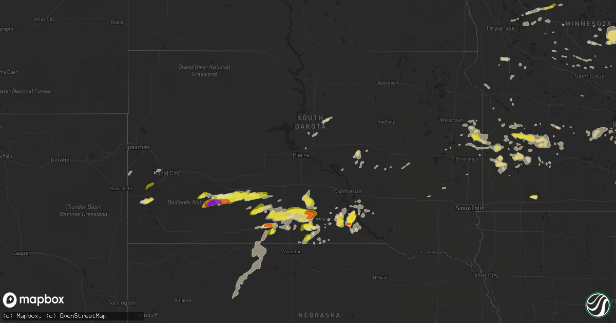
Hail Map in South Dakota on June 30, 2019
Get this storm
June 30 map
$229
one time, instant access
Download today. No call, no setup
Keep the $229
Bought the map and want the full workflow? Apply the entire $229 to a subscription within 7 days. None of it is wasted.
Every map, not just this one
This buys you this map. Subscription and you get every map we run, in the markets you choose from a few cities to whole states to nationwide. Plus real-time alerts the moment a storm fires.
Contact data
Name, contact info, occupancy, even credit band for addresses in the footprint. You go from where it hit to who to call.
Become the source they trust
Unlimited branding weather history reports on demand. You already have the documented answer ready for the property owner, and you are the one who showed up with it.
Property data and RoofTrace estimates
Pull up any address you have got, its value and the exact code rules for that jurisdiction, straight from One Click Code. Then RoofTrace estimates the squares, pitch, and roof value, priced the way you price.
Storm reports in South Dakota
South Dakota
| Date | Description |
|---|---|
| 06/30/20196:46 PM CDT | A local report indicates 1.00 inch wind near 2 S IONA |
| 06/30/20196:30 PM CDT | Large shed was damaged... Lifted off it's foundation by winds. |
| 06/30/20196:26 PM CDT | A local report indicates 1.00 inch wind near 13 NE COLOME |
| 06/30/20196:25 PM CDT | A local report indicates 1.00 inch wind near 7 SE KADOKA |
| 06/30/20196:20 PM CDT | A local report indicates 1.00 inch wind near 3 SW DIXON |
| 06/30/20196:08 PM CDT | A local report indicates 60 MPH wind near 10 S KADOKA |
| 06/30/20195:46 PM CDT | A local report indicates 1.00 inch wind near 8 SE INTERIOR |
| 06/30/20195:36 PM CDT | A local report indicates 70 MPH wind near INTERIOR |
| 06/30/20195:34 PM CDT | A local report indicates 1.00 inch wind near 13 WNW PLATTE |
| 06/30/20195:30 PM CDT | Multiple hailstones 2.0 to 2.5 inches in diameter measured with a ruler. |
| 06/30/20195:10 PM CDT | A local report indicates 1.75 inch wind near 17 N KYLE |
| 06/30/20194:35 PM CDT | Tornado was on the ground thru at least 4:38 pm. |
| 06/30/20194:28 PM CDT | Tornado lifted at 4:36 pm. |
| 06/30/20194:28 PM CDT | Multiple reports of tornado from the public. |
| 06/30/20194:27 PM CDT | A local report indicates 1.75 inch wind near 7 N BURKE |
| 06/30/20197:10 AM CDT | At 1209 PM MDT, a severe thunderstorm was located 5 miles east of Osage, or 9 miles northwest of Newcastle, moving northeast at 25 mph. HAZARD...Quarter size hail. SOURCE...Radar indicated. IMPACT...Damage to vehicles is expected. Locations impacted include... Osage, Flag Mountain, Four Corners, Buckhorn, Deerfield, Moskee, Crooks Tower, Mallo Camp, O'Neil Pass and Redbank Spring Campground. |
| 06/30/20195:23 AM CDT | At 1023 PM CDT, a severe thunderstorm was located near Kimball, moving east at 20 mph. HAZARD...60 mph wind gusts. SOURCE...Radar indicated. IMPACT...Expect damage to roofs, siding, and trees. This severe thunderstorm will be near... Kimball around 1035 PM CDT. Grass Ranch Colony around 1040 PM CDT. White Lake around 1110 PM CDT. |
| 06/30/20192:56 AM CDT | At 755 PM CDT, severe thunderstorms were located along a line extending from near Witten to 7 miles northeast of Lakeview, moving southeast at 20 mph. HAZARD...Ping pong ball size hail and 60 mph wind gusts. SOURCE...Radar indicated. IMPACT...People and animals outdoors will be injured. Expect hail damage to roofs, siding, windows, and vehicles. Expect wind damage to roofs, siding, and trees. Locations impacted include... Colome, Millboro, Keyapaha, Lakeview, Hidden Timber, Clearfield, Littleburg, Wewela, Haystack Butte and Dog Ear Lake. |
| 06/30/20192:30 AM CDT | Calf shelter blown over and destroyed. Time approximate. |
| 06/30/20192:26 AM CDT | At 726 PM CDT, severe thunderstorms were located along a line extending from 11 miles south of Earling Hills to 4 miles east of Mosher to 2 miles north of Okreek, moving east at 25 mph. HAZARD...60 mph wind gusts and half dollar size hail. SOURCE...Radar indicated. IMPACT...Hail damage to vehicles is expected. Expect wind damage to roofs, siding, and trees. Locations impacted include... Winner, Okreek, Ideal, Wood, Carter, Mosher, Witten and Hamill. |
| 06/30/20192:22 AM CDT | At 721 PM CDT, a severe thunderstorm was located 14 miles south of 5 Mile Corner, or 17 miles southwest of Presho, and is nearly stationary. HAZARD...60 mph wind gusts and quarter size hail. SOURCE...Radar indicated. IMPACT...Hail damage to vehicles is expected. Expect wind damage to roofs, siding, and trees. This severe thunderstorm will remain over mainly rural areas of west central Lyman County. |
| 06/30/20192:10 AM CDT | At 710 PM CDT, severe thunderstorms were located along a line extending from 6 miles north of Keyapaha to 4 miles northeast of Clearfield, moving east at 15 mph. HAZARD...Golf ball size hail and 60 mph wind gusts. SOURCE...Radar indicated. IMPACT...People and animals outdoors will be injured. Expect hail damage to roofs, siding, windows, and vehicles. Expect wind damage to roofs, siding, and trees. Locations impacted include... Winner, Colome, Okreek, Carter, Millboro, Keyapaha, Hidden Timber, Clearfield, Haystack Butte and Dog Ear Lake. |
| 06/30/20192:02 AM CDT | At 701 PM CDT, a severe thunderstorm was located over Wood, or 12 miles east of White River, moving east at 25 mph. HAZARD...Ping pong ball size hail. SOURCE...Radar indicated. IMPACT...People and animals outdoors will be injured. Expect damage to roofs, siding, windows, and vehicles. Locations impacted include... Wood and Mosher. |
| 06/30/20191:54 AM CDT | At 654 PM CDT, a severe thunderstorm was located 4 miles southwest of Parmelee, or 20 miles west of Mission, moving east at 25 mph. HAZARD...Ping pong ball size hail and 60 mph wind gusts. SOURCE...Radar indicated. IMPACT...People and animals outdoors will be injured. Expect hail damage to roofs, siding, windows, and vehicles. Expect wind damage to roofs, siding, and trees. Locations impacted include... Mission, Rosebud, Saint Francis, Parmelee, Spring Creek and Lakeview. |
| 06/30/20191:21 AM CDT | At 620 PM CDT, a severe thunderstorm was located 10 miles north of Dallas, or 14 miles east of Winner, moving north at 15 mph. HAZARD...Ping pong ball size hail and 60 mph wind gusts. SOURCE...Radar indicated. IMPACT...People and animals outdoors will be injured. Expect hail damage to roofs, siding, windows, and vehicles. Expect wind damage to roofs, siding, and trees. This severe thunderstorm will remain over east central Tripp County northeast of Colome. |
| 06/30/20191:18 AM CDT | At 618 PM CDT, a severe thunderstorm was located near Belvidere, or 10 miles southeast of Kadoka, moving east at 45 mph. HAZARD...70 mph wind gusts and half dollar size hail. SOURCE...Radar indicated. IMPACT...Hail damage to vehicles is expected. Expect considerable tree damage. Wind damage is also likely to mobile homes, roofs, and outbuildings. Locations impacted include... Murdo, Okaton and Westover. |
| 06/30/201912:58 AM CDT | At 557 PM CDT, a severe thunderstorm was located over Dallas, or 19 miles east of Winner, moving east at 20 mph. HAZARD...Ping pong ball size hail. SOURCE...Radar indicated. IMPACT...People and animals outdoors will be injured. Expect damage to roofs, siding, windows, and vehicles. This severe thunderstorm will be near... Gregory around 610 PM CDT. Burke around 630 PM CDT. |
| 06/30/201912:17 AM CDT | At 517 PM CDT, a severe thunderstorm was located 12 miles northeast of Gregory, or 29 miles east of Winner, moving northeast at 15 mph. HAZARD...Ping pong ball size hail and 60 mph wind gusts. SOURCE...Radar indicated. IMPACT...People and animals outdoors will be injured. Expect hail damage to roofs, siding, windows, and vehicles. Expect wind damage to roofs, siding, and trees. This severe thunderstorm will remain over mainly rural areas of northwestern Charles Mix, northwestern Gregory and south central Brule Counties. |
| 06/30/201912:14 AM CDT | At 514 PM MDT/614 PM CDT/, a severe thunderstorm was located 6 miles southeast of Intersection of Highway 73 and White River, or 9 miles southeast of Kadoka, moving east at 30 mph. HAZARD...70 mph wind gusts and half dollar size hail. SOURCE...Radar indicated. IMPACT...Hail damage to vehicles is expected. Expect considerable tree damage. Wind damage is also likely to mobile homes, roofs, and outbuildings. Locations impacted include... Kadoka, White River, Norris, Belvidere, Cedar Butte, Intersection of Highway 73 and White River and Intersection of Highway 83 and White River.This includes Interstate 90 in South Dakota between Mile Markers 148and 174. |
| 06/30/201912:01 AM CDT | A local report indicates 58 MPH wind near 1 NNW HURON |
| 06/29/201911:42 PM CDT | Tree damage and power outage from wind gusts estimated at 65 mph. Time estimated from radar. |
| 06/29/201911:22 PM CDT | At 421 PM MDT, a severe thunderstorm was located 5 miles south of Interior, or 26 miles southwest of Kadoka, moving east at 30 mph. HAZARD...Golf ball size hail and 70 mph wind gusts. SOURCE...Radar indicated. IMPACT...People and animals outdoors will be injured. Expect hail damage to roofs, siding, windows, and vehicles. Expect considerable tree damage. Wind damage is also likely to mobile homes, roofs, and outbuildings. Locations impacted include... Kadoka, Potato Creek, Wanblee, Long Valley, Interior, Cedar Pass, Eagle Nest Butte and Intersection of Highway 73 and White River.This includes Interstate 90 in South Dakota between Mile Markers 137and 157. |
| 06/29/201910:41 PM CDT | At 341 PM MDT, a severe thunderstorm was located 4 miles southeast of Badlands National Park, or 44 miles southwest of Philip, moving northeast at 20 mph. HAZARD...60 mph wind gusts and half dollar size hail. SOURCE...Radar indicated. IMPACT...Hail damage to vehicles is expected. Expect wind damage to roofs, siding, and trees. Locations impacted include... Potato Creek, Scenic, Badlands National Park, Sheep Mountain Table, Delta 9 Missile Silo and Pinnacles Ranger Station.This includes Interstate 90 in South Dakota between Mile Markers 114and 119. |
| 06/29/201910:30 PM CDT | Tree damage from wind gusts estimated at 60 mph. Time estimated from radar. |
| 06/29/201910:01 PM CDT | At 300 PM MDT, a severe thunderstorm was located 3 miles north of Pringle, or 7 miles south of Custer, moving east at 25 mph. HAZARD...Half dollar size hail. SOURCE...Radar indicated. IMPACT...Damage to vehicles is expected. Locations impacted include... Pringle, Wind Cave National Park, Blue Bell, Custer State Park, Mount Coolidge, Legion Lake, Buffalo Corrals and State Game Lodge. |
| 06/29/20199:36 PM CDT | At 236 PM MDT, a severe thunderstorm was located near Black Hawk, or 7 miles northwest of Rapid City, moving east at 25 mph. HAZARD...Quarter size hail. SOURCE...Radar indicated. IMPACT...Damage to vehicles is expected. Locations impacted include... Northern Rapid City, Ellsworth Air Force Base, Box Elder, Black Hawk, Summerset and Piedmont.This includes Interstate 90 in South Dakota between Mile Markers 45and 58. |
| 06/29/20199:35 PM CDT | A local report indicates 60 MPH wind near 1 ESE GREGORY |
| 06/29/20198:45 PM CDT | 3 trees down in toronto. Time approximate. |
| 06/29/20198:40 PM CDT | Trees down. |
| 06/29/20198:30 PM CDT | Estimated winds of 40 to 60 mph. |
| 06/29/20198:22 PM CDT | A local report indicates 58 MPH wind near 1 NE WINNER |
| 06/29/20198:00 PM CDT | A local report indicates 1.00 inch wind near 6 NW CLEARFIELD |
| 06/29/20197:58 PM CDT | A local report indicates 1.75 inch wind near 1 S CARTER |
| 06/29/20197:34 PM CDT | A local report indicates 1.00 inch wind near 3 WNW MOSHER |
| 06/29/20197:27 PM CDT | A local report indicates 60 MPH wind near 3 N CLEARFIELD |
| 06/29/20197:15 PM CDT | A local report indicates 1.00 inch wind near 1 S WOOD |
| 06/29/20197:08 PM CDT | A local report indicates 1.00 inch wind near 3 SW PARMELEE |
All States Impacted by Hail Map on June 30, 2019
Cities Impacted by Hail Map on June 30, 2019
- Shakopee, MN
- Jordan, MN
- Stockton, IL
- Hill City, SD
- Walnut Grove, MN
- Midkiff, TX
- Newark, IL
- Minooka, IL
- Channahon, IL
- Shorewood, IL
- Morris, IL
- Miller, SD
- Adams, MN
- Nashville, IN
- McCamey, TX
- Crane, TX
- Sebring, FL
- Argenta, IL
- Cerro Gordo, IL
- Bremen, ME
- Bristol, ME
- Cranston, RI
- West Warwick, RI
- Hope, RI
- Warwick, RI
- Johnston, RI
- East Greenwich, RI
- Kyle, SD
- Elkton, SD
- Ottertail, MN
- Richville, MN
- Gaylord, MN
- Cologne, MN
- Hamburg, MN
- Norwood Young America, MN
- Henderson, MN
- Glencoe, MN
- Green Isle, MN
- Plato, MN
- Arlington, MN
- Young America, MN
- Spencer, SD
- Middleboro, MA
- Kendall, WI
- Saint Joseph, IL
- New Richland, MN
- Waseca, MN
- Kansas, IL
- Gregory, SD
- Dallas, SD
- Burke, SD
- Winner, SD
- Hamill, SD
- Bloomington, IN
- Ellettsville, IN
- Lodi, WI
- Dane, WI
- Prairie Du Sac, WI
- Madison, WI
- Waunakee, WI
- Sauk City, WI
- Mount Horeb, WI
- Mazomanie, WI
- Verona, WI
- Middleton, WI
- Cross Plains, WI
- Hume, IL
- Metcalf, IL
- Lee, IL
- Aurora, IL
- Montgomery, IL
- Yorkville, IL
- Oswego, IL
- Sugar Grove, IL
- Plano, IL
- Big Rock, IL
- Bristol, IL
- Fairbanks, IN
- Shelburn, IN
- Wellington, IL
- Hoopeston, IL
- Lodge Grass, MT
- Cheyenne, WY
- Jasper, IN
- Walworth, WI
- Williams Bay, WI
- Fontana, WI
- Lake Geneva, WI
- Delavan, WI
- Otter, MT
- Orfordville, WI
- Imperial, TX
- Ashkum, IL
- Mattoon, IL
- Lance Creek, WY
- Big Timber, MT
- Scales Mound, IL
- Rewey, WI
- Bloomington, WI
- Mineral Point, WI
- Platteville, WI
- Benton, WI
- Shullsburg, WI
- Highland, WI
- Belmont, WI
- Livingston, WI
- Linden, WI
- Dodgeville, WI
- Fennimore, WI
- Mount Hope, WI
- Lancaster, WI
- Cuba City, WI
- Potosi, WI
- Darlington, WI
- Marengo, IL
- Lewellen, NE
- Arthur, NE
- Salem, IN
- Campbellsburg, IN
- West Point, KY
- Muldraugh, KY
- Lewisport, KY
- Wisconsin Rapids, WI
- Oakland, IL
- Garrison, MN
- Wahkon, MN
- Onamia, MN
- Red Wing, MN
- Sidney, NE
- Macon, IL
- Boody, IL
- Moweaqua, IL
- Brazil, IN
- Pekin, IN
- Borden, IN
- Campton, KY
- Russell, MN
- Tyler, MN
- Rossville, IL
- Williamsport, IN
- Hendricks, MN
- Evansville, WI
- Beloit, WI
- Brodhead, WI
- Cornell, WI
- Holcombe, WI
- Peetz, CO
- Mooresville, IN
- Montgomery, IN
- Fredericksburg, IN
- Verndale, MN
- Black River Falls, WI
- Platte, SD
- Seneca, IL
- Parmelee, SD
- Saint Francis, SD
- Sheridan, WY
- Camden, AR
- Lime Springs, IA
- Chester, IA
- Le Roy, MN
- Sparland, IL
- Henry, IL
- Varna, IL
- Lacon, IL
- Toluca, IL
- Weldona, CO
- Merrillan, WI
- Mason City, IA
- Manly, IA
- Pierz, MN
- Hillman, MN
- Onida, SD
- Fairfax, MN
- Franklin, MN
- Frankfort, KY
- Spearsville, LA
- Lamberton, MN
- Norwalk, WI
- Sparta, WI
- Tomah, WI
- Wilton, WI
- Rochdale, MA
- North Oxford, MA
- Auburn, MA
- Freedom, IN
- Coal City, IN
- White, SD
- Cannon Falls, MN
- Grover, CO
- Farmingville, NY
- Holtsville, NY
- Penfield, IL
- Loda, IL
- Ludlow, IL
- Cissna Park, IL
- Rankin, IL
- Potomac, IL
- Buckley, IL
- Paxton, IL
- Hardinsburg, IN
- Rice, MN
- Sauk Rapids, MN
- Springfield, KY
- Saint Catharine, KY
- Fort Morgan, CO
- Keenesburg, CO
- Roggen, CO
- Watertown, WI
- Jay Em, WY
- Fort Laramie, WY
- Bonfield, IL
- Kankakee, IL
- East Islip, NY
- Oakdale, NY
- Great River, NY
- Oregon, IL
- Chana, IL
- Ashton, IL
- Palm Bay, FL
- Melville, MT
- Newcastle, WY
- Seymour, IN
- Elizabethtown, IN
- Columbus, IN
- Seaforth, MN
- Vesta, MN
- Sacred Heart, MN
- Danube, MN
- Hanley Falls, MN
- Cottonwood, MN
- Olivia, MN
- Belview, MN
- Echo, MN
- Morton, MN
- Redwood Falls, MN
- Renville, MN
- Wood Lake, MN
- Wabasso, MN
- Salem, SD
- Winfred, SD
- Montrose, SD
- Marion, LA
- Lebanon, SD
- Mora, MN
- Ogilvie, MN
- Hanover, IN
- Nabb, IN
- Lexington, IN
- Hager City, WI
- Lead, SD
- Dubuque, IA
- Durango, IA
- Cassville, WI
- Holy Cross, IA
- Glen Haven, WI
- North Buena Vista, IA
- Wanblee, SD
- Interior, SD
- Kadoka, SD
- Wood Lake, NE
- Granite Falls, MN
- Gays Mills, WI
- Amana, IA
- Carbon, IN
- Rosedale, IN
- Reelsville, IN
- Bedford, IN
- Custer, SD
- Greencastle, IN
- Ideal, SD
- La Motte, IA
- Bellevue, IA
- Ruthton, MN
- Keystone, SD
- Siren, WI
- Charleston, IL
- Sterling City, TX
- Eagle Bend, MN
- Kimball, SD
- New York Mills, MN
- Sutton, MA
- Oxford, MA
- Belfry, KY
- Sidney, KY
- Austin, MN
- Kersey, CO
- Homer, IL
- Fairmount, IL
- Fithian, IL
- Big Lake, TX
- Brandt, SD
- Hinckley, MN
- Grantsburg, WI
- Pine City, MN
- Camp Douglas, WI
- Rockville, IN
- Cody, NE
- Nenzel, NE
- Kilgore, NE
- New Prague, MN
- Chrisman, IL
- Franktown, CO
- Castle Rock, CO
- Thorp, WI
- Greenwood, WI
- Clear Lake, SD
- Crow Agency, MT
- Vesper, WI
- Conrath, WI
- Madison, MN
- Toronto, SD
- Arco, MN
- Brookings, SD
- Minneota, MN
- Ivanhoe, MN
- Bruce, SD
- Ellsworth, NE
- Bingham, NE
- Elsie, NE
- Attica, IN
- Covington, IN
- West Lebanon, IN
- Realitos, TX
- Upton, WY
- Oxford, WI
- Endeavor, WI
- Orlando, FL
- Moore Haven, FL
- Clewiston, FL
- Athol, MA
- Petersham, MA
- Osage, WY
- Somerset, WI
- Holland, MN
- Lake Benton, MN
- Balaton, MN
- Woodstock, MN
- Springfield, MN
- Spring Green, WI
- Plain, WI
- Milford, IL
- Merriman, NE
- Whitman, NE
- Veteran, WY
- Waltham, MN
- Bohemia, NY
- Islip Terrace, NY
- Central Islip, NY
- Sayville, NY
- Brentwood, NY
- Islandia, NY
- Hauppauge, NY
- Islip, NY
- West Sayville, NY
- Reed Point, MT
- Freeport, MN
- Albany, MN
- Canby, MN
- Gary, SD
- Estelline, SD
- Astoria, SD
- Remer, MN
- Kimball, MN
- South Hamilton, MA
- Essex, MA
- Long Valley, SD
- Alvin, IL
- Danville, IL
- Georgetown, IL
- Cayuga, IN
- Hillsdale, IN
- Dana, IN
- Ridge Farm, IL
- Joliet, IL
- Plainfield, IL
- Elkhart, IL
- Lingle, WY
- Flat Lick, KY
- Barbourville, KY
- Nekoosa, WI
- Port Edwards, WI
- Hollis, NH
- Orleans, IN
- Ellsworth, WI
- Bay City, WI
- Glen Flora, WI
- Hardin, MT
- Hayward, MN
- Herrick, SD
- Finlayson, MN
- McGrath, MN
- Withee, WI
- Owen, WI
- Lublin, WI
- Fairbury, IL
- Adams, WI
- Friendship, WI
- Okabena, MN
- Merrimac, WI
- Portage, WI
- Baraboo, WI
- Lagrange, WY
- Orchard, CO
- Deer Creek, MN
- Henning, MN
- Norris, SD
- Wonewoc, WI
- Cazenovia, WI
- Suffolk, VA
- Herman, MN
- Briggsville, WI
- Grand Marsh, WI
- Wisconsin Dells, WI
- Hill City, MN
- Wadena, MN
- Sebeka, MN
- Hillpoint, WI
- Marshall, MN
- Bethany, IL
- Hastings, MN
- Valentine, NE
- Sleepy Eye, MN
- Morgan, MN
- Ellendale, MN
- Poland, IN
- Cloverdale, IN
- Spencer, IN
- Versailles, KY
- Danforth, IL
- Neillsville, WI
- Granton, WI
- Brooklyn, WI
- Centerpoint, IN
- Crest Hill, IL
- Elwood, IL
- Sarona, WI
- Birchwood, WI
- Frederic, WI
- Fenton, IL
- Morrison, IL
- Stoneham, CO
- Palisade, MN
- Mahomet, IL
- Fisher, IL
- Tracy, MN
- Wheatland, WY
- Bighorn, MT
- Grand Rapids, MN
- Forsyth, MT
- Ashland, MT
- Lame Deer, MT
- Billerica, MA
- Burlington, MA
- New Raymer, CO
- Williamsburg, VA
- Champaign, IL
- Thomasboro, IL
- Urbana, IL
- Sherrill, IA
- Brewster, MN
- Lakefield, MN
- Longville, MN
- West Union, IL
- Birney, MT
- Hammond, IL
- Shoals, IN
- Loogootee, IN
- Eastman, WI
- Wilmington, IL
- Elroy, WI
- Sidell, IL
- Osage, IA
- Marseilles, IL
- Sheridan, IL
- Torrington, WY
- Warrens, WI
- Hayfield, MN
- Dorchester, WI
- Abbotsford, WI
- Curtiss, WI
- Colby, WI
- Spencer, WI
- Unity, WI
- Vineyard Haven, MA
- Edgartown, MA
- Prior Lake, MN
- Lakeville, MN
- Manville, WY
- Lusk, WY
- Dexter, MN
- Lyle, MN
- Brownsdale, MN
- Rose Creek, MN
- McIntire, IA
- Blooming Prairie, MN
- Riceville, IA
- Elkton, MN
- Taopi, MN
- Sargeant, MN
- Stacyville, IA
- Dodge Center, MN
- Ferryville, WI
- Soldiers Grove, WI
- Mount Morris, IL
- Leaf River, IL
- German Valley, IL
- Bird Island, MN
- Belle Plaine, MN
- Alpena, SD
- Racine, MN
- Albert Lea, MN
- Grand Meadow, MN
- Saint Ansgar, IA
- Claremont, MN
- Stewartville, MN
- Glenville, MN
- Little Cedar, IA
- Kasson, MN
- Mitchell, IN
- Sullivan, IN
- Farmersburg, IN
- Elizabeth, IN
- Fort Knox, KY
- Corydon, IN
- Laconia, IN
- Lancaster, KY
- Hanlontown, IA
- Kensett, IA
- Wood, SD
- Presho, SD
- Pukwana, SD
- Hillsboro, WI
- Haxtun, CO
- Fleming, CO
- Gann Valley, SD
- Wyoming, IL
- Commack, NY
- Smithtown, NY
- South Wayne, WI
- Aitkin, MN
- Webster, MN
- Witten, SD
- White River, SD
- Mission, SD
- Okreek, SD
- Harmon, IL
- Waldoboro, ME
- Dawson, MN
- Ramsey, IN
- Belle Plaine, IA
- Hampton, AR
- Brainerd, MN
- Menomonie, WI
- Boulder, CO
- Nederland, CO
- Billings, MT
- Solsberry, IN
- Bloomfield, IN
- Junction, TX
- Sparks, NE
- Isle, MN
- Nerstrand, MN
- Kenyon, MN
- Lillie, LA
- Chebanse, IL
- Herscher, IL
- Swatara, MN
- Outing, MN
- East Northport, NY
- Ronkonkoma, NY
- Northport, NY
- Kings Park, NY
- Colome, SD
- Akron, CO
- Willard, WI
- Marshfield, WI
- Chili, WI
- San Diego, TX
- Stitzer, WI
- Ridgefield, CT
- Danbury, CT
- Chugwater, WY
- Mattapoisett, MA
- Amelia Court House, VA
- Rapid City, SD
- New Richmond, WI
- Hudson, WI
- Arkdale, WI
- Babcock, WI
- Pittsville, WI
- Necedah, WI
- Clear Lake, IA
- Nora Springs, IA
- Rock Falls, IL
- Goodwin, SD
- Otisco, IN
- Marysville, IN
- Clifton, IL
- Cabery, IL
- Savage, MN
- Sundance, WY
- Holmes, NY
- Patterson, NY
- Brewster, NY
- Redding, CT
- Cascade, IA
- Epworth, IA
- Bernard, IA
- Meriden, WY
- Burns, WY
- Weston, CT
- Gillette, WY
- Lawrenceburg, KY
- Loyal, WI
- Hebron, IL
- Richmond, IL
- Wonder Lake, IL
- Guttenberg, IA
- Madison, IN
- Spragueville, IA
- Maquoketa, IA
- Andrew, IA
- Arlington, SD
- Marshall, IL
- Leopold, IN
- Sulphur, IN
- English, IN
- Leavenworth, IN
- Boston, KY
- Putnamville, IN
- Fillmore, IN
- Jolo, WV
- Carson, VA
- Dinwiddie, VA
- Stanley, WI
- Ree Heights, SD
- Milton, NY
- Prophetstown, IL
- Clarkfield, MN
- Taunton, MN
- Harmony, MN
- Paragon, IN
- Tony, WI
- McGregor, IA
- Harpers Ferry, IA
- Monona, IA
- Browerville, MN
- Harris, MN
- North Branch, MN
- Milan, MN
- Paris, IL
- Ashmore, IL
- Brocton, IL
- Strasburg, IL
- Serena, IL
- Gilman, IL
- Onarga, IL
- Armstrong, IL
- Tinley Park, IL
- Milaca, MN
- Foreston, MN
- Rockton, IL
- Coatesville, IN
- Dubois, IN
- Haynesville, LA
- Eros, LA
- Calhoun, LA
- West Monroe, LA
- Pine Bluffs, WY
- Ohio, IL
- Hyden, KY
- Scenic, SD
- Marshall, IN
- Bloomingdale, IN
- Little Falls, MN
- Peosta, IA
- Farley, IA
- Slayton, MN
- Garvin, MN
- Waveland, IN
- Strong, AR
- El Dorado, AR
- Nokomis, IL
- Cannelton, IN
- Derby, IN
- Kennan, WI
- Owatonna, MN
- Chamberlain, SD
- Steward, IL
- Wiggins, CO
- La Place, IL
- Castlewood, SD
- Okeechobee, FL
- Palmyra, IN
- Hoffman, MN
- Snyder, CO
- Otis, CO
- Chidester, AR
- Farmerville, LA
- Monroe, LA
- Prudence Island, RI
- Watseka, IL
- Ottawa, IL
- Westport, CT
- Wilton, CT
- Verona, IL
- Mazon, IL
- Gifford, IL
- Ogden, IL
- Elburn, IL
- Geneva, IL
- Leola, AR
- Oakwood, IL
- Lost Nation, IA
- Delmar, IA
- Orange Grove, TX
- Farwell, MN
- Welch, MN
- Lynd, MN
- Milroy, MN
- Springview, NE
- Centereach, NY
- Rawlings, VA
- Hector, MN
- Lake Wilson, MN
- New Washington, IN
- Oak Park, MN
- Sanborn, MN
- Arena, WI
- Barneveld, WI
- Blue Mounds, WI
- Carpenter, WY
- New Auburn, WI
- Jim Falls, WI
- Bruce, WI
- Bloomer, WI
- Glendo, WY
- Fulton, IL
- Albany, IL
- Erie, IL
- Clinton, IA
- Mansfield, IL
- Shongaloo, LA
- Tilton, IL
- Buffalo Lake, MN
- Braceville, IL
- Coal City, IL
- Braidwood, IL
- Kingman, IN
- Darien, WI
- Avalon, WI
- Gratiot, WI
- Ortonville, MN
- Clinton, MN
- Harrisburg, NE
- Pine Island, MN
- Byron, MN
- Lake Villa, IL
- Antioch, IL
- Tuthill, SD
- Allerton, IL
- Crescent City, IL
- Buckingham, IL
- Vero Beach, FL
- Yoder, WY
- Hulett, WY
- Grand Mound, IA
- Cambridge, MN
- Hampton, MN
- Lone Rock, WI
- Avoca, WI
- Sterling, CO
- Nicholasville, KY
- Wilmore, KY
- Kilkenny, MN
- Coyanosa, TX
- Boyd, MN
- Davenport, IA
- Bradford, IL
- Gibson City, IL
- Evanston, IN
- Lamar, IN
- Grandview, IN
- Staples, MN
- Pearl City, IL
- Rantoul, IL
- Burtrum, MN
- Shrewsbury, MA
- Milltown, IN
- Depauw, IN
- Cavour, SD
- Warren, IL
- Nora, IL
- Lena, IL
- Mathis, TX
- Northfield, MN
- Winchester, KY
- Saint Lawrence, SD
- Garnavillo, IA
- New Vienna, IA
- Colesburg, IA
- Morris, MN
- Hancock, MN
- Tuscola, IL
- Custer, MT
- Loganville, WI
- Fort Thompson, SD
- Poynette, WI
- Austin, IN
- Battle Lake, MN
- Martinsville, IN
- Monrovia, IN
- Lerna, IL
- Emily, MN
- Strandburg, SD
- Hyannis, NE
- Elmwood, WI
- Harrodsburg, KY
- Carver, MN
- Colman, SD
- Flandreau, SD
- Marion, MA
- Long Prairie, MN
- Swanville, MN
- Lucan, MN
- Coxs Creek, KY
- Plympton, MA
- Halifax, MA
- Hancock, WI
- Palestine, IL
- Newman, IL
- Villa Grove, IL
- Murdock, IL
- Camargo, IL
- Richmond, KY
- Hurley, VA
- Hawkins, WI
- Decorah, IA
- Bowlus, MN
- Royalton, MN
- Appleton, MN
- Crystal Lake, IL
- Mchenry, IL
- Island Lake, IL
- Lovington, IL
- Decatur, IL
- Crookston, NE
- Longview, IL
- Sidney, IL
- Broadlands, IL
- Owaneco, IL
- Pana, IL
- Greenup, IL
- Dalton City, IL
- Scottsburg, IN
- North Freedom, WI
- Eldridge, IA
- Long Grove, IA
- Margarettsville, NC
- Donnelly, MN
- Lanark, IL
- Mount Carroll, IL
- Bowling Green, IN
- Busy, KY
- Joice, IA
- Rockford, IA
- Fertile, IA
- Sauk Centre, MN
- Belvidere, SD
- Grafton, IA
- Northwood, IA
- Carpenter, IA
- Plymouth, IA
- Branchville, IN
- Toulon, IL
- Medford, WI
- Geneseo, IL
- Pardeeville, WI
- Alden, MN
- Hartland, MN
- Bismarck, IL
- Montezuma, IN
- Ladysmith, WI
- Gilman, WI
- Mount Pulaski, IL
- Emington, IL
- Goldsmith, TX
- Dalton, NE
- Lebanon Junction, KY
- Ghent, MN
- Baldwin, IA
- Charlton, MA
- Trafalgar, IN
- Clermont, KY
- Shepherdsville, KY
- Mount Washington, KY
- McKenney, VA
- Eldena, IL
- Dixon, IL
- Fillmore, IL
- Paoli, IN
- Barronett, WI
- Deforest, WI
- Cadott, WI
- Boyd, WI
- Lodgepole, NE
- Crook, CO
- Bagley, WI
- Dix, NE
- Indianola, IL
- Unionville, IN
- Morgantown, IN
- Faribault, MN
- Dennison, MN
- Mundelein, IL
- Grayslake, IL
- Readstown, WI
- Amherst, NH
- Milford, NH
- Janesville, WI
- Underwood, MN
- Woonsocket, SD
- Huron, SD
- Artesian, SD
- Wessington Springs, SD
- Milton, WI
- Bangs, TX
- Santa Anna, TX
- Avon, MN
- Holdingford, MN
- Wallace, NE
- Humboldt, IL
- West Baden Springs, IN
- Boswell, IN
- Bardstown, KY
- Elko New Market, MN
- Farmington, MN
- Pierre, SD
- Salem, WI
- West Terre Haute, IN
- Deputy, IN
- Rosemount, MN
- Wauzeka, WI
- Greene, IA
- Lake Placid, FL
- Fellsmere, FL
- Eau Galle, WI
- Colfax, IL
- Cropsey, IL
- Crewe, VA
- Hazel Green, WI
- Stafford Springs, CT
- Somers, CT
- Bainbridge, IN
- Sheldon, WI
- Wessington, SD
- Merino, CO
- Freeport, IL
- Shannon, IL
- Bushnell, NE
- Downing, WI
- Knapp, WI
- Boyceville, WI
- Clarissa, MN
- Stacy, MN
- Gravel Switch, KY
- Cresco, IA
- Poughquag, NY
- Gays, IL
- Clay City, IN
- Cannelburg, IN
- Grey Eagle, MN
- French Lick, IN
- Gray, KY
- Corbin, KY
- Rochelle, IL
- Athens, IL
- Greenview, IL
- Middletown, IL
- Wall, SD
- Galena, IL
- Taylorsville, KY
- Star Prairie, WI
- Ford, VA
- Lowry, MN
- Starbuck, MN
- Spring Valley, MN
- Ostrander, MN
- Worthington, IN
- Stilesville, IN
- Chaska, MN
- Bristow, IN
- Mcgregor, MN
- Sartell, MN
- Saint Stephen, MN
- Mt Zion, IL
- Mertzon, TX
- Birdseye, IN
- Stewart, MN
- East Troy, WI
- Fairchild, WI
- Arlington, WI
- Fairfield, CT
- Sandwich, IL
- Romeoville, IL
- Essex, IL
- Manhattan, IL
- Millington, IL
- Lockport, IL
- Savanna, IL
- Barrington, IL
- Wauconda, IL
- Wedron, IL
- Brownwood, TX
- Bena, MN
- Deer River, MN
- Hopewell Junction, NY
- Hawk Springs, WY
- Westborough, MA
- Northborough, MA
- Oshkosh, NE
- Ashby, NE
- Saint Xavier, MT
- Greycliff, MT
- Broadus, MT
- Morrisonville, WI
- Dalton, WI
- Cambria, WI
- Deerfield, WI
- Rio, WI
- Waterloo, WI
- Sun Prairie, WI
- Marshall, WI
- Cottage Grove, WI
- Montello, WI
- Columbus, WI
- Reedsburg, WI
- Windsor, WI
- Wyocena, WI
- Edwardsport, IN
- Patoka, IN
- Webster, KY
- La Grange, IL
- Lafayette, IN
- Otterbein, IN
- Dundee, IL
- Momence, IL
- Terre Haute, IN
- Plainville, IN
- Ladoga, IN
- Fox River Grove, IL
- Libertyville, IL
- Princeton, IN
- Glendale Heights, IL
- Owensboro, KY
- Pine Village, IN
- Lombard, IL
- Fowler, IN
- Caneyville, KY
- Lowell, IN
- Mount Prospect, IL
- Hutsonville, IL
- Flat Rock, IL
- Templeton, IN
- Norman, IN
- Collison, IL
- Nashotah, WI
- Lisle, IL
- Petersburg, IN
- Tennyson, IN
- Hanover Park, IL
- Fort Branch, IN
- Perrysville, IN
- West York, IL
- Universal, IN
- Palos Park, IL
- Garfield, KY
- Sheldon, IL
- Summit Argo, IL
- Philo, IL
- Olaton, KY
- Big Clifty, KY
- Washington, IN
- Goodland, IN
- Okauchee, WI
- Merom, IN
- Eastview, KY
- Knightsville, IN
- Hinsdale, IL
- Evansville, IN
- West Chicago, IL
- New Market, IN
- Scotland, IN
- Oconomowoc, WI
- Medora, IN
- Clinton, IN
- Park Forest, IL
- Chandler, IN
- Oaktown, IN
- Romney, IN
- Elberfeld, IN
- Carpentersville, IL
- Trevor, WI
- Savoy, IL
- Beaverville, IL
- New Richmond, IN
- Grant Park, IL
- Santa Claus, IN
- Gosport, IN
- Villa Park, IL
- Earl Park, IN
- Pewaukee, WI
- Ambia, IN
- Monroe City, IN
- Hymera, IN
- Wingate, IN
- Manteno, IL
- Pembroke Township, IL
- West Lafayette, IN
- Iroquois, IL
- Waynetown, IN
- Casey, IL
- Newburgh, IN
- Westville, IL
- Grantsburg, IN
- Cynthiana, IN
- Pimento, IN
- Henning, IL
- Cary, IL
- Payneville, KY
- Sandborn, IN
- Hillsboro, IN
- Stendal, IN
- Darien, IL
- Willowbrook, IL
- Franklin Park, IL
- Waukesha, WI
- Fordsville, KY
- Holland, IN
- Twin Lakes, WI
- Jasonville, IN
- Haubstadt, IN
- Winfield, IL
- Schaumburg, IL
- Ringwood, IL
- Harmony, IN
- Remington, IN
- Genoa City, WI
- Palatine, IL
- Monee, IL
- Oak Brook, IL
- Justice, IL
- Russellville, IN
- Dugger, IN
- Lake Forest, IL
- Battletown, KY
- Sullivan, WI
- Burlington, WI
- Otwell, IN
- Coalmont, IN
- Annapolis, IL
- Prospect Heights, IL
- Williams, IN
- Mokena, IL
- McDaniels, KY
- Crane, IN
- Vallonia, IN
- Lincoln City, IN
- Wheeling, IL
- New Goshen, IN
- Roachdale, IN
- Rhodelia, KY
- Glenview, IL
- Guston, KY
- Union Star, KY
- Taswell, IN
- New Salisbury, IN
- Calhoun, KY
- Bartlett, IL
- Reed, KY
- Ragsdale, IN
- Robinson, IL
- Springfield, WI
- Wayne, IL
- Stone Park, IL
- Sadorus, IL
- Saint Anne, IL
- Westview, KY
- Hawesville, KY
- Catlin, IL
- Boonville, IN
- Owensville, IN
- Mukwonago, WI
- Spottsville, KY
- Roselle, IL
- Mauckport, IN
- Horse Branch, KY
- Poseyville, IN
- Lincolnshire, IL
- Westphalia, IN
- Wheaton, IL
- Deerfield, IL
- Elk Grove Village, IL
- Muncie, IL
- Saint Francisville, IL
- Lawrenceville, IL
- Hartford, KY
- Lake Zurich, IL
- Melrose Park, IL
- Wales, WI
- Naperville, IL
- Bensenville, IL
- Vermilion, IL
- Custer, KY
- Dousman, WI
- New Lenox, IL
- Ingleside, IL
- Redmon, IL
- Wheatland, IN
- Mecca, IN
- Brandenburg, KY
- Spurgeon, IN
- Freelandville, IN
- Quincy, IN
- Woodstock, IL
- Downers Grove, IL
- Dundee, KY
- Wood Dale, IL
- Harned, KY
- Owensburg, IN
- Carol Stream, IL
- Mount Vernon, IN
- Bolingbrook, IL
- Oxford, IN
- Vine Grove, KY
- Broadview, IL
- Whitesville, KY
- Wilmot, WI
- Westchester, IL
- Huntingburg, IN
- Velpen, IN
- Martinton, IL
- Newberry, IN
- Western Springs, IL
- Richton Park, IL
- Arlington Heights, IL
- Willow Springs, IL
- Winslow, IN
- Tolono, IL
- Martinsville, IL
- Westfield, IL
- Celestine, IN
- Palmyra, WI
- Lyons, IN
- Algonquin, IL
- Union Hill, IL
- Addison, IL
- La Grange Park, IL
- Maywood, IL
- Lewis, IN
- Troy, IN
- Gentryville, IN
- Bicknell, IN
- Hindsboro, IL
- Hillside, IL
- Schiller Park, IL
- Henderson, KY
- Carlisle, IN
- Rolling Meadows, IL
- North Prairie, WI
- Elmhurst, IL
- Saint Anthony, IN
- Cloverport, KY
- Oolitic, IN
- Pesotum, IL
- Switz City, IN
- Chrisney, IN
- Glen Ellyn, IL
- Brook, IN
- State Line, IN
- Medinah, IL
- Hardinsburg, KY
- Ashippun, WI
- Stockland, IL
- Rockport, IN
- Ixonia, WI
- Reynolds Station, KY
- Veedersburg, IN
- Des Plaines, IL
- Staunton, IN
- Lebanon, WI
- Dennison, IL
- Streamwood, IL
- Arcola, IL
- Aroma Park, IL
- Brookfield, IL
- Clarendon Hills, IL
- Tell City, IN
- Odon, IN
- Marengo, IN
- Linton, IN
- Ferdinand, IN
- Mellott, IN
- Wadesville, IN
- Richland, IN
- Reddick, IL
- Livermore, KY
- Leitchfield, KY
- Eagle, WI
- Elgin, IL
- Elnora, IN
- Berkeley, IL
- Dale, IN
- Allendale, IL
- Oakland City, IN
- Maceo, KY
- Westmont, IL
- Frankfort, IL
- Vernon Hills, IL
- Heltonville, IN
- Saint Meinrad, IN
- Round Lake, IL
- Lemont, IL
- Beecher, IL
- Decker, IN
- Eckerty, IN
- Orland Park, IL
- Robards, KY
- Morocco, IN
- Palos Hills, IL
- Irvington, KY
- Papineau, IL
- Woodridge, IL
- Donovan, IL
- Central, IN
- Cecilia, KY
- Fox Lake, IL
- Rome, IN
- Riley, IN
- Spring Grove, IL
- Rineyville, KY
- Crete, IL
- Stinesville, IN
- Ekron, KY
- Peotone, IL
- Lynnville, IN
- Bruceville, IN
- Hazleton, IN
- Lake Village, IN
- Tunnelton, IN
- Alamo, IN
- Hartland, WI
- Avoca, IN
- Philpot, KY
- Warrenville, IL
- Hoffman Estates, IL
- Bloomingdale, IL
- Bridgeton, IN
- Dewey, IL
- Bourbonnais, IL
- Itasca, IL
- Bradley, IL
- Northbrook, IL
- Stephensport, KY
- Francisco, IN
- Buffalo Grove, IL
- Kentland, IN
- Hickory Hills, IL
- Homer Glen, IL
- Elkhorn, WI
- Crawfordsville, IN
- Falls Of Rough, KY
- University Park, IL
- Westpoint, IN
- Royal, IL
- Schnellville, IN
- Cory, IN
- Hudson, KY
- Patricksburg, IN
- Bellwood, IL
- Springville, IN
- Delafield, WI
- Helenville, WI
- Newtown, IN
- Vincennes, IN
- Utica, KY
- Saint Croix, IN
- Matteson, IL
- Whitewater, WI
- Arlington, IA
- Mineral, IL
- Ophiem, IL
- Woodhull, IL
- Anamosa, IA
- Manlius, IL
- Plainfield, IA
- Walnut, IL
- Dixon, IA
- Center Junction, IA
- New Liberty, IA
- Floyd, IA
- Hanover, IL
- Spillville, IA
- Teeds Grove, IA
- Rock Island, IL
- Fredericksburg, IA
- Blue Grass, IA
- Dahinda, IL
- Oelwein, IA
- Le Claire, IA
- Tipton, IA
- Alta Vista, IA
- Altona, IL
- Robins, IA
- Clermont, IA
- Calmar, IA
- Urbana, IA
- Sabula, IA
- Earlville, IA
- Oxford Junction, IA
- Princeton, IA
- Coggon, IA
- Galesburg, IL
- Miles, IA
- Polo, IL
- Oneida, IL
- Victoria, IL
- Stanley, IA
- Rio, IL
- Waucoma, IA
- Kieler, WI
- Worthington, IA
- Bettendorf, IA
- Hopkinton, IA
- Postville, IA
- Carbon Cliff, IL
- Cedar Rapids, IA
- Andover, IL
- Masonville, IA
- New Bedford, IL
- Buda, IL
- Wilton, IA
- Camanche, IA
- Mount Vernon, IA
- Fairbank, IA
- New Windsor, IL
- Cordova, IL
- Laura, IL
- Williamsfield, IL
- Ridgeway, IA
- McCausland, IA
- Elizabeth, IL
- Wataga, IL
- Lowden, IA
- Speer, IL
- Saint Lucas, IA
- Aurora, IA
- Apple River, IL
- Ely, IA
- Bishop Hill, IL
- Charles City, IA
- Sterling, IL
- Shellsburg, IA
- Marion, IA
- Ossian, IA
- Jesup, IA
- Volga, IA
- Pleasant Valley, IA
- Dunlap, IL
- Cambridge, IL
- Garber, IA
- Preston, IA
- Wyanet, IL
- Durant, IA
- Luxemburg, IA
- Delaware, IA
- Mechanicsville, IA
- Lawler, IA
- East Moline, IL
- Putnam, IL
- Goose Lake, IA
- Port Byron, IL
- Knoxville, IL
- Low Moor, IA
- Deer Grove, IL
- Brandon, IA
- Castalia, IA
- Neponset, IL
- Wyoming, IA
- Silvis, IL
- Martelle, IA
- Alpha, IL
- Springville, IA
- Calamus, IA
- Walcott, IA
- Delhi, IA
- Orchard, IA
- Readlyn, IA
- Forreston, IL
- Annawan, IL
- Ionia, IA
- Lisbon, IA
- Vinton, IA
- Dickeyville, WI
- Clarence, IA
- Sherrard, IL
- Onslow, IA
- New Hampton, IA
- Montfort, WI
- Brimfield, IL
- Osco, IL
- Nashua, IA
- Elmwood, IL
- Bryant, IA
- Elma, IA
- Ryan, IA
- Monmouth, IA
- West Union, IA
- Edelstein, IL
- Wheatland, IA
- Frederika, IA
- Sheffield, IL
- Lyndon, IL
- Princeville, IL
- Maynard, IA
- De Witt, IA
- Lamont, IA
- Westgate, IA
- Manchester, IA
- Rapids City, IL
- Independence, IA
- Solon, IA
- Colona, IL
- Chillicothe, IL
- Wadena, IA
- East Dubuque, IL
- Morley, IA
- Hawkeye, IA
- Stanwood, IA
- Orion, IL
- Milledgeville, IL
- Thomson, IL
- Olin, IA
- Hiawatha, IA
- Hampton, IL
- Palo, IA
- Fayette, IA
- Central City, IA
- Greeley, IA
- Dyersville, IA
- Welton, IA
- Alburnett, IA
- Waverly, IA
- Elkport, IA
- Center Point, IA
- Sumner, IA
- Protivin, IA
- Kent, IL
- Milan, IL
- Lynn Center, IL
- Edgewood, IA
- Monticello, IA
- Charlotte, IA
- Hillsdale, IL
- Princeton, IL
- Elkader, IA
- Randalia, IA
- Stockton, IA
- Dundee, IA
- Winthrop, IA
- Oran, IA
- Strawberry Point, IA
- Langworthy, IA
- Elgin, IA
- Bennett, IA
- Zwingle, IA
- Tiskilwa, IL
- Donahue, IA
- Colwell, IA
- Kewanee, IL
- Chadwick, IL
- Atkinson, IL
- Hazleton, IA
- Rowley, IA
- Fort Atkinson, IA
- Quasqueton, IA
- Tripoli, IA
- Moline, IL
- Walker, IA
- Coal Valley, IL
- Tampico, IL
- Galva, IL
- Toddville, IA
- Hooppole, IL
- La Fayette, IL
- Prairieburg, IA


