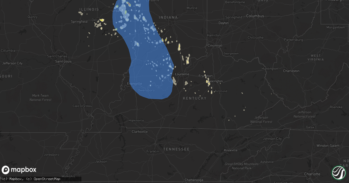
Hail Map in Kentucky on June 30, 2019
Get this storm
June 30 map
$229
one time, instant access
Download today. No call, no setup
Keep the $229
Bought the map and want the full workflow? Apply the entire $229 to a subscription within 7 days. None of it is wasted.
Every map, not just this one
This buys you this map. Subscription and you get every map we run, in the markets you choose from a few cities to whole states to nationwide. Plus real-time alerts the moment a storm fires.
Contact data
Name, contact info, occupancy, even credit band for addresses in the footprint. You go from where it hit to who to call.
Become the source they trust
Unlimited branding weather history reports on demand. You already have the documented answer ready for the property owner, and you are the one who showed up with it.
Property data and RoofTrace estimates
Pull up any address you have got, its value and the exact code rules for that jurisdiction, straight from One Click Code. Then RoofTrace estimates the squares, pitch, and roof value, priced the way you price.
Storm reports in Kentucky
Kentucky
| Date | Description |
|---|---|
| 06/30/20195:20 PM CDT | Trees down on troy pike. |
| 06/30/20194:44 PM CDT | Tree down in the 1100 block of kirksville rd. |
| 06/30/201912:35 PM CDT | Utility lines were blown down onto us 421. The blown down lines resulted in a 3 car pileup on us 421. |
| 06/30/20193:56 AM CDT | At 855 PM EDT/755 PM CDT/, gusty winds head of a line of thunderstorms were from 16 miles north of Leitchfield to near Hardinsburg to near Knottsville, moving southeast at 50 mph. HAZARD...60 mph wind gusts. SOURCE...Radar indicated. IMPACT...Expect damage to roofs, siding, and trees. Locations impacted include... Leitchfield, Clarkson, Caneyville, Fordsville, Concord, Mcquady, Dyer, Rock Creek, Ralph, and Se Ree. |
| 06/30/20193:22 AM CDT | At 820 PM CDT, the leading edge of an area of strong, gusty winds was from 7 miles north of Hartford to 16 miles north of Morgantown to near Leitchfield, moving south at 35 mph. HAZARD...60 mph wind gusts. SOURCE...Radar indicated. IMPACT...Expect damage to roofs, siding, and trees. Locations impacted include... Leitchfield, Hartford, Morgantown, Casey, Lee, Beaver Dam, Caneyville, Centertown, Mchenry, and Rockport.These winds have had a history of being strong enough to fell trees. |
| 06/30/20193:01 AM CDT | At 801 PM EDT/701 PM CDT/, severe thunderstorms were located along a line extending from 7 miles southwest of Jasper to 18 miles southwest of Paoli to near English to 13 miles south of Brandenburg, moving south at 25 mph. HAZARD...60 mph wind gusts. SOURCE...Radar indicated. IMPACT...Expect damage to roofs, siding, and trees. Locations impacted include... Tell City, Hardinsburg, Mount Pleasant, Ferdinand, Cannelton, Leopold, Troy, Ranger, Gerald and Adyeville. |
| 06/30/20192:42 AM CDT | At 740 PM CDT, severe winds out ahead of approaching thunderstorms were located along a line extending from near Mount Vernon to near Evansville to near Eureka to Hawesville, moving southeast at 50 mph. There have been reports of 50 to 60 mph winds with this line. HAZARD...60 mph wind gusts. SOURCE...Trained weather spotters. IMPACT...Expect damage to roofs, siding, and trees. Locations impacted include... Evansville, Owensboro, Henderson, Newburgh, Rockport, Corydon, Whitesville, Robards, Knottsville, St. Joseph, Masonville, Stanley, Eureka, Moseleyville, Pleasant Ridge and Hebbardsville. |
| 06/30/20191:36 AM CDT | At 636 PM EDT, a severe thunderstorm was located 8 miles east of Shepherdsville, moving south at 20 mph. HAZARD...60 mph wind gusts and penny size hail. SOURCE...Radar indicated. IMPACT...Expect damage to roofs, siding, and trees. Locations impacted include... Bardstown, Samuels, Highgrove, Solitude, Deatsville, Withrow, Bourbon Springs, Brownington, Lotus and Coxs Creek. |
| 06/30/20191:32 AM CDT | At 631 PM EDT, severe thunderstorms were located along a line extending from near Versailles to near Lawrenceburg, moving southeast at 20 mph. HAZARD...60 mph wind gusts and nickel size hail. SOURCE...Radar indicated. IMPACT...Expect damage to roofs, siding, and trees. Locations impacted include... Nicholasville, Lawrenceburg, Versailles, Wilmore, Oregon, Vanarsdell, Ebenezer, Bondville, Talmage, and Tyrone.Trees were reported down in Woodford County. |
| 06/30/20191:13 AM CDT | At 613 PM EDT, a severe thunderstorm was located near Frankfort, moving southeast at 20 mph. HAZARD...60 mph wind gusts and penny size hail. SOURCE...Radar indicated. IMPACT...Expect damage to roofs, siding, and trees. Locations impacted include... Versailles, Mckees Crossroads, Firmantown, Milner, Gaybourn, Bonita, Millville, Tyrone and Duckers. |
| 06/30/201912:40 AM CDT | At 539 PM EDT, a severe thunderstorm was located near Lancaster, moving south at 10 mph. HAZARD...60 mph wind gusts and nickel size hail. SOURCE...Radar indicated. IMPACT...Expect damage to roofs, siding, and trees. Locations impacted include... Lancaster, Mccreary, Hyattsville, Buckeye, Marcellus, Bourne, Teatersville, Marksbury, Bryantsville, and Stone. |
| 06/30/201912:26 AM CDT | At 526 PM EDT, a severe thunderstorm was located 7 miles north of Frankfort, moving south at 15 mph. HAZARD...60 mph wind gusts and nickel size hail. SOURCE...Radar indicated. IMPACT...Expect damage to roofs, siding, and trees. Locations impacted include... Frankfort, Elsinore, Harvieland and Ottusville. |
| 06/30/201912:16 AM CDT | At 516 PM EDT, severe thunderstorms were located along a line extending from near Scottsburg to 12 miles north of Prospect to 8 miles northwest of La Grange, moving south at 15 mph. HAZARD...60 mph wind gusts and penny size hail. SOURCE...Radar indicated. IMPACT...Expect damage to roofs, siding, and trees. Locations impacted include... Charlestown, Owen, Goshen, River Bluff, Henryville, Underwood, Clark Siding, Harmony Village, Skylight and New Liberty. |
| 06/29/201911:41 PM CDT | At 440 PM EDT, a severe thunderstorm was located 8 miles southwest of Madison, moving south at 15 mph. HAZARD...70 mph wind gusts and quarter size hail. SOURCE...Radar indicated. IMPACT...Hail damage to vehicles is expected. Expect considerable tree damage. Wind damage is also likely to mobile homes, roofs, and outbuildings. Locations impacted include... Otto, New Washington and Paynesville. |
| 06/29/20198:27 PM CDT | Tree down on ky 1414 near hartford... Ky. |
| 06/29/20198:23 PM CDT | Grayson county dispatch reports a tree down on claggett road. County highway department had to be called to remove it. |
| 06/29/20198:12 PM CDT | At 112 PM EDT, a severe thunderstorm was located over Thousandsticks, or over Hyden, moving southeast at 15 mph. HAZARD...60 mph wind gusts and quarter size hail. SOURCE...Radar indicated. IMPACT...Hail damage to vehicles is expected. Expect wind damage to roofs, siding, and trees. Locations impacted include... Hyden, Yeaddiss, Big Fork, Hosea, Leatherwood, Hoskinston, Essie, Cinda, Dryhill, Smilax, Mozelle and Daley. |
| 06/29/20198:10 PM CDT | Tree down on zion church road. |
| 06/29/20198:05 PM CDT | Report of trees and power lines down scattered across town. Time estimated by radar. |
| 06/29/20198:04 PM CDT | Trees down around mcquady. St. Marys church road and ky 105. |
| 06/29/20197:41 PM CDT | Tree down in the 200 block of 7th st. |
| 06/29/20197:41 PM CDT | Large cedar tree down on hwy 60 near ky 144. |
| 06/29/20197:40 PM CDT | Tree on house in cloverport with electric lines downed as a result. |
| 06/29/20197:37 PM CDT | Trees down around stephensburg. |
| 06/29/20197:15 PM CDT | Multiple trees were blown down. |
| 06/29/20197:15 PM CDT | Multiple trees were blown down. |
| 06/29/20197:05 PM CDT | Tree down on quail run rd and garrett rd. |
All States Impacted by Hail Map on June 30, 2019
Cities Impacted by Hail Map on June 30, 2019
- Shakopee, MN
- Jordan, MN
- Stockton, IL
- Hill City, SD
- Walnut Grove, MN
- Midkiff, TX
- Newark, IL
- Minooka, IL
- Channahon, IL
- Shorewood, IL
- Morris, IL
- Miller, SD
- Adams, MN
- Nashville, IN
- McCamey, TX
- Crane, TX
- Sebring, FL
- Argenta, IL
- Cerro Gordo, IL
- Bremen, ME
- Bristol, ME
- Cranston, RI
- West Warwick, RI
- Hope, RI
- Warwick, RI
- Johnston, RI
- East Greenwich, RI
- Kyle, SD
- Elkton, SD
- Ottertail, MN
- Richville, MN
- Gaylord, MN
- Cologne, MN
- Hamburg, MN
- Norwood Young America, MN
- Henderson, MN
- Glencoe, MN
- Green Isle, MN
- Plato, MN
- Arlington, MN
- Young America, MN
- Spencer, SD
- Middleboro, MA
- Kendall, WI
- Saint Joseph, IL
- New Richland, MN
- Waseca, MN
- Kansas, IL
- Gregory, SD
- Dallas, SD
- Burke, SD
- Winner, SD
- Hamill, SD
- Bloomington, IN
- Ellettsville, IN
- Lodi, WI
- Dane, WI
- Prairie Du Sac, WI
- Madison, WI
- Waunakee, WI
- Sauk City, WI
- Mount Horeb, WI
- Mazomanie, WI
- Verona, WI
- Middleton, WI
- Cross Plains, WI
- Hume, IL
- Metcalf, IL
- Lee, IL
- Aurora, IL
- Montgomery, IL
- Yorkville, IL
- Oswego, IL
- Sugar Grove, IL
- Plano, IL
- Big Rock, IL
- Bristol, IL
- Fairbanks, IN
- Shelburn, IN
- Wellington, IL
- Hoopeston, IL
- Lodge Grass, MT
- Cheyenne, WY
- Jasper, IN
- Walworth, WI
- Williams Bay, WI
- Fontana, WI
- Lake Geneva, WI
- Delavan, WI
- Otter, MT
- Orfordville, WI
- Imperial, TX
- Ashkum, IL
- Mattoon, IL
- Lance Creek, WY
- Big Timber, MT
- Scales Mound, IL
- Rewey, WI
- Bloomington, WI
- Mineral Point, WI
- Platteville, WI
- Benton, WI
- Shullsburg, WI
- Highland, WI
- Belmont, WI
- Livingston, WI
- Linden, WI
- Dodgeville, WI
- Fennimore, WI
- Mount Hope, WI
- Lancaster, WI
- Cuba City, WI
- Potosi, WI
- Darlington, WI
- Marengo, IL
- Lewellen, NE
- Arthur, NE
- Salem, IN
- Campbellsburg, IN
- West Point, KY
- Muldraugh, KY
- Lewisport, KY
- Wisconsin Rapids, WI
- Oakland, IL
- Garrison, MN
- Wahkon, MN
- Onamia, MN
- Red Wing, MN
- Sidney, NE
- Macon, IL
- Boody, IL
- Moweaqua, IL
- Brazil, IN
- Pekin, IN
- Borden, IN
- Campton, KY
- Russell, MN
- Tyler, MN
- Rossville, IL
- Williamsport, IN
- Hendricks, MN
- Evansville, WI
- Beloit, WI
- Brodhead, WI
- Cornell, WI
- Holcombe, WI
- Peetz, CO
- Mooresville, IN
- Montgomery, IN
- Fredericksburg, IN
- Verndale, MN
- Black River Falls, WI
- Platte, SD
- Seneca, IL
- Parmelee, SD
- Saint Francis, SD
- Sheridan, WY
- Camden, AR
- Lime Springs, IA
- Chester, IA
- Le Roy, MN
- Sparland, IL
- Henry, IL
- Varna, IL
- Lacon, IL
- Toluca, IL
- Weldona, CO
- Merrillan, WI
- Mason City, IA
- Manly, IA
- Pierz, MN
- Hillman, MN
- Onida, SD
- Fairfax, MN
- Franklin, MN
- Frankfort, KY
- Spearsville, LA
- Lamberton, MN
- Norwalk, WI
- Sparta, WI
- Tomah, WI
- Wilton, WI
- Rochdale, MA
- North Oxford, MA
- Auburn, MA
- Freedom, IN
- Coal City, IN
- White, SD
- Cannon Falls, MN
- Grover, CO
- Farmingville, NY
- Holtsville, NY
- Penfield, IL
- Loda, IL
- Ludlow, IL
- Cissna Park, IL
- Rankin, IL
- Potomac, IL
- Buckley, IL
- Paxton, IL
- Hardinsburg, IN
- Rice, MN
- Sauk Rapids, MN
- Springfield, KY
- Saint Catharine, KY
- Fort Morgan, CO
- Keenesburg, CO
- Roggen, CO
- Watertown, WI
- Jay Em, WY
- Fort Laramie, WY
- Bonfield, IL
- Kankakee, IL
- East Islip, NY
- Oakdale, NY
- Great River, NY
- Oregon, IL
- Chana, IL
- Ashton, IL
- Palm Bay, FL
- Melville, MT
- Newcastle, WY
- Seymour, IN
- Elizabethtown, IN
- Columbus, IN
- Seaforth, MN
- Vesta, MN
- Sacred Heart, MN
- Danube, MN
- Hanley Falls, MN
- Cottonwood, MN
- Olivia, MN
- Belview, MN
- Echo, MN
- Morton, MN
- Redwood Falls, MN
- Renville, MN
- Wood Lake, MN
- Wabasso, MN
- Salem, SD
- Winfred, SD
- Montrose, SD
- Marion, LA
- Lebanon, SD
- Mora, MN
- Ogilvie, MN
- Hanover, IN
- Nabb, IN
- Lexington, IN
- Hager City, WI
- Lead, SD
- Dubuque, IA
- Durango, IA
- Cassville, WI
- Holy Cross, IA
- Glen Haven, WI
- North Buena Vista, IA
- Wanblee, SD
- Interior, SD
- Kadoka, SD
- Wood Lake, NE
- Granite Falls, MN
- Gays Mills, WI
- Amana, IA
- Carbon, IN
- Rosedale, IN
- Reelsville, IN
- Bedford, IN
- Custer, SD
- Greencastle, IN
- Ideal, SD
- La Motte, IA
- Bellevue, IA
- Ruthton, MN
- Keystone, SD
- Siren, WI
- Charleston, IL
- Sterling City, TX
- Eagle Bend, MN
- Kimball, SD
- New York Mills, MN
- Sutton, MA
- Oxford, MA
- Belfry, KY
- Sidney, KY
- Austin, MN
- Kersey, CO
- Homer, IL
- Fairmount, IL
- Fithian, IL
- Big Lake, TX
- Brandt, SD
- Hinckley, MN
- Grantsburg, WI
- Pine City, MN
- Camp Douglas, WI
- Rockville, IN
- Cody, NE
- Nenzel, NE
- Kilgore, NE
- New Prague, MN
- Chrisman, IL
- Franktown, CO
- Castle Rock, CO
- Thorp, WI
- Greenwood, WI
- Clear Lake, SD
- Crow Agency, MT
- Vesper, WI
- Conrath, WI
- Madison, MN
- Toronto, SD
- Arco, MN
- Brookings, SD
- Minneota, MN
- Ivanhoe, MN
- Bruce, SD
- Ellsworth, NE
- Bingham, NE
- Elsie, NE
- Attica, IN
- Covington, IN
- West Lebanon, IN
- Realitos, TX
- Upton, WY
- Oxford, WI
- Endeavor, WI
- Orlando, FL
- Moore Haven, FL
- Clewiston, FL
- Athol, MA
- Petersham, MA
- Osage, WY
- Somerset, WI
- Holland, MN
- Lake Benton, MN
- Balaton, MN
- Woodstock, MN
- Springfield, MN
- Spring Green, WI
- Plain, WI
- Milford, IL
- Merriman, NE
- Whitman, NE
- Veteran, WY
- Waltham, MN
- Bohemia, NY
- Islip Terrace, NY
- Central Islip, NY
- Sayville, NY
- Brentwood, NY
- Islandia, NY
- Hauppauge, NY
- Islip, NY
- West Sayville, NY
- Reed Point, MT
- Freeport, MN
- Albany, MN
- Canby, MN
- Gary, SD
- Estelline, SD
- Astoria, SD
- Remer, MN
- Kimball, MN
- South Hamilton, MA
- Essex, MA
- Long Valley, SD
- Alvin, IL
- Danville, IL
- Georgetown, IL
- Cayuga, IN
- Hillsdale, IN
- Dana, IN
- Ridge Farm, IL
- Joliet, IL
- Plainfield, IL
- Elkhart, IL
- Lingle, WY
- Flat Lick, KY
- Barbourville, KY
- Nekoosa, WI
- Port Edwards, WI
- Hollis, NH
- Orleans, IN
- Ellsworth, WI
- Bay City, WI
- Glen Flora, WI
- Hardin, MT
- Hayward, MN
- Herrick, SD
- Finlayson, MN
- McGrath, MN
- Withee, WI
- Owen, WI
- Lublin, WI
- Fairbury, IL
- Adams, WI
- Friendship, WI
- Okabena, MN
- Merrimac, WI
- Portage, WI
- Baraboo, WI
- Lagrange, WY
- Orchard, CO
- Deer Creek, MN
- Henning, MN
- Norris, SD
- Wonewoc, WI
- Cazenovia, WI
- Suffolk, VA
- Herman, MN
- Briggsville, WI
- Grand Marsh, WI
- Wisconsin Dells, WI
- Hill City, MN
- Wadena, MN
- Sebeka, MN
- Hillpoint, WI
- Marshall, MN
- Bethany, IL
- Hastings, MN
- Valentine, NE
- Sleepy Eye, MN
- Morgan, MN
- Ellendale, MN
- Poland, IN
- Cloverdale, IN
- Spencer, IN
- Versailles, KY
- Danforth, IL
- Neillsville, WI
- Granton, WI
- Brooklyn, WI
- Centerpoint, IN
- Crest Hill, IL
- Elwood, IL
- Sarona, WI
- Birchwood, WI
- Frederic, WI
- Fenton, IL
- Morrison, IL
- Stoneham, CO
- Palisade, MN
- Mahomet, IL
- Fisher, IL
- Tracy, MN
- Wheatland, WY
- Bighorn, MT
- Grand Rapids, MN
- Forsyth, MT
- Ashland, MT
- Lame Deer, MT
- Billerica, MA
- Burlington, MA
- New Raymer, CO
- Williamsburg, VA
- Champaign, IL
- Thomasboro, IL
- Urbana, IL
- Sherrill, IA
- Brewster, MN
- Lakefield, MN
- Longville, MN
- West Union, IL
- Birney, MT
- Hammond, IL
- Shoals, IN
- Loogootee, IN
- Eastman, WI
- Wilmington, IL
- Elroy, WI
- Sidell, IL
- Osage, IA
- Marseilles, IL
- Sheridan, IL
- Torrington, WY
- Warrens, WI
- Hayfield, MN
- Dorchester, WI
- Abbotsford, WI
- Curtiss, WI
- Colby, WI
- Spencer, WI
- Unity, WI
- Vineyard Haven, MA
- Edgartown, MA
- Prior Lake, MN
- Lakeville, MN
- Manville, WY
- Lusk, WY
- Dexter, MN
- Lyle, MN
- Brownsdale, MN
- Rose Creek, MN
- McIntire, IA
- Blooming Prairie, MN
- Riceville, IA
- Elkton, MN
- Taopi, MN
- Sargeant, MN
- Stacyville, IA
- Dodge Center, MN
- Ferryville, WI
- Soldiers Grove, WI
- Mount Morris, IL
- Leaf River, IL
- German Valley, IL
- Bird Island, MN
- Belle Plaine, MN
- Alpena, SD
- Racine, MN
- Albert Lea, MN
- Grand Meadow, MN
- Saint Ansgar, IA
- Claremont, MN
- Stewartville, MN
- Glenville, MN
- Little Cedar, IA
- Kasson, MN
- Mitchell, IN
- Sullivan, IN
- Farmersburg, IN
- Elizabeth, IN
- Fort Knox, KY
- Corydon, IN
- Laconia, IN
- Lancaster, KY
- Hanlontown, IA
- Kensett, IA
- Wood, SD
- Presho, SD
- Pukwana, SD
- Hillsboro, WI
- Haxtun, CO
- Fleming, CO
- Gann Valley, SD
- Wyoming, IL
- Commack, NY
- Smithtown, NY
- South Wayne, WI
- Aitkin, MN
- Webster, MN
- Witten, SD
- White River, SD
- Mission, SD
- Okreek, SD
- Harmon, IL
- Waldoboro, ME
- Dawson, MN
- Ramsey, IN
- Belle Plaine, IA
- Hampton, AR
- Brainerd, MN
- Menomonie, WI
- Boulder, CO
- Nederland, CO
- Billings, MT
- Solsberry, IN
- Bloomfield, IN
- Junction, TX
- Sparks, NE
- Isle, MN
- Nerstrand, MN
- Kenyon, MN
- Lillie, LA
- Chebanse, IL
- Herscher, IL
- Swatara, MN
- Outing, MN
- East Northport, NY
- Ronkonkoma, NY
- Northport, NY
- Kings Park, NY
- Colome, SD
- Akron, CO
- Willard, WI
- Marshfield, WI
- Chili, WI
- San Diego, TX
- Stitzer, WI
- Ridgefield, CT
- Danbury, CT
- Chugwater, WY
- Mattapoisett, MA
- Amelia Court House, VA
- Rapid City, SD
- New Richmond, WI
- Hudson, WI
- Arkdale, WI
- Babcock, WI
- Pittsville, WI
- Necedah, WI
- Clear Lake, IA
- Nora Springs, IA
- Rock Falls, IL
- Goodwin, SD
- Otisco, IN
- Marysville, IN
- Clifton, IL
- Cabery, IL
- Savage, MN
- Sundance, WY
- Holmes, NY
- Patterson, NY
- Brewster, NY
- Redding, CT
- Cascade, IA
- Epworth, IA
- Bernard, IA
- Meriden, WY
- Burns, WY
- Weston, CT
- Gillette, WY
- Lawrenceburg, KY
- Loyal, WI
- Hebron, IL
- Richmond, IL
- Wonder Lake, IL
- Guttenberg, IA
- Madison, IN
- Spragueville, IA
- Maquoketa, IA
- Andrew, IA
- Arlington, SD
- Marshall, IL
- Leopold, IN
- Sulphur, IN
- English, IN
- Leavenworth, IN
- Boston, KY
- Putnamville, IN
- Fillmore, IN
- Jolo, WV
- Carson, VA
- Dinwiddie, VA
- Stanley, WI
- Ree Heights, SD
- Milton, NY
- Prophetstown, IL
- Clarkfield, MN
- Taunton, MN
- Harmony, MN
- Paragon, IN
- Tony, WI
- McGregor, IA
- Harpers Ferry, IA
- Monona, IA
- Browerville, MN
- Harris, MN
- North Branch, MN
- Milan, MN
- Paris, IL
- Ashmore, IL
- Brocton, IL
- Strasburg, IL
- Serena, IL
- Gilman, IL
- Onarga, IL
- Armstrong, IL
- Tinley Park, IL
- Milaca, MN
- Foreston, MN
- Rockton, IL
- Coatesville, IN
- Dubois, IN
- Haynesville, LA
- Eros, LA
- Calhoun, LA
- West Monroe, LA
- Pine Bluffs, WY
- Ohio, IL
- Hyden, KY
- Scenic, SD
- Marshall, IN
- Bloomingdale, IN
- Little Falls, MN
- Peosta, IA
- Farley, IA
- Slayton, MN
- Garvin, MN
- Waveland, IN
- Strong, AR
- El Dorado, AR
- Nokomis, IL
- Cannelton, IN
- Derby, IN
- Kennan, WI
- Owatonna, MN
- Chamberlain, SD
- Steward, IL
- Wiggins, CO
- La Place, IL
- Castlewood, SD
- Okeechobee, FL
- Palmyra, IN
- Hoffman, MN
- Snyder, CO
- Otis, CO
- Chidester, AR
- Farmerville, LA
- Monroe, LA
- Prudence Island, RI
- Watseka, IL
- Ottawa, IL
- Westport, CT
- Wilton, CT
- Verona, IL
- Mazon, IL
- Gifford, IL
- Ogden, IL
- Elburn, IL
- Geneva, IL
- Leola, AR
- Oakwood, IL
- Lost Nation, IA
- Delmar, IA
- Orange Grove, TX
- Farwell, MN
- Welch, MN
- Lynd, MN
- Milroy, MN
- Springview, NE
- Centereach, NY
- Rawlings, VA
- Hector, MN
- Lake Wilson, MN
- New Washington, IN
- Oak Park, MN
- Sanborn, MN
- Arena, WI
- Barneveld, WI
- Blue Mounds, WI
- Carpenter, WY
- New Auburn, WI
- Jim Falls, WI
- Bruce, WI
- Bloomer, WI
- Glendo, WY
- Fulton, IL
- Albany, IL
- Erie, IL
- Clinton, IA
- Mansfield, IL
- Shongaloo, LA
- Tilton, IL
- Buffalo Lake, MN
- Braceville, IL
- Coal City, IL
- Braidwood, IL
- Kingman, IN
- Darien, WI
- Avalon, WI
- Gratiot, WI
- Ortonville, MN
- Clinton, MN
- Harrisburg, NE
- Pine Island, MN
- Byron, MN
- Lake Villa, IL
- Antioch, IL
- Tuthill, SD
- Allerton, IL
- Crescent City, IL
- Buckingham, IL
- Vero Beach, FL
- Yoder, WY
- Hulett, WY
- Grand Mound, IA
- Cambridge, MN
- Hampton, MN
- Lone Rock, WI
- Avoca, WI
- Sterling, CO
- Nicholasville, KY
- Wilmore, KY
- Kilkenny, MN
- Coyanosa, TX
- Boyd, MN
- Davenport, IA
- Bradford, IL
- Gibson City, IL
- Evanston, IN
- Lamar, IN
- Grandview, IN
- Staples, MN
- Pearl City, IL
- Rantoul, IL
- Burtrum, MN
- Shrewsbury, MA
- Milltown, IN
- Depauw, IN
- Cavour, SD
- Warren, IL
- Nora, IL
- Lena, IL
- Mathis, TX
- Northfield, MN
- Winchester, KY
- Saint Lawrence, SD
- Garnavillo, IA
- New Vienna, IA
- Colesburg, IA
- Morris, MN
- Hancock, MN
- Tuscola, IL
- Custer, MT
- Loganville, WI
- Fort Thompson, SD
- Poynette, WI
- Austin, IN
- Battle Lake, MN
- Martinsville, IN
- Monrovia, IN
- Lerna, IL
- Emily, MN
- Strandburg, SD
- Hyannis, NE
- Elmwood, WI
- Harrodsburg, KY
- Carver, MN
- Colman, SD
- Flandreau, SD
- Marion, MA
- Long Prairie, MN
- Swanville, MN
- Lucan, MN
- Coxs Creek, KY
- Plympton, MA
- Halifax, MA
- Hancock, WI
- Palestine, IL
- Newman, IL
- Villa Grove, IL
- Murdock, IL
- Camargo, IL
- Richmond, KY
- Hurley, VA
- Hawkins, WI
- Decorah, IA
- Bowlus, MN
- Royalton, MN
- Appleton, MN
- Crystal Lake, IL
- Mchenry, IL
- Island Lake, IL
- Lovington, IL
- Decatur, IL
- Crookston, NE
- Longview, IL
- Sidney, IL
- Broadlands, IL
- Owaneco, IL
- Pana, IL
- Greenup, IL
- Dalton City, IL
- Scottsburg, IN
- North Freedom, WI
- Eldridge, IA
- Long Grove, IA
- Margarettsville, NC
- Donnelly, MN
- Lanark, IL
- Mount Carroll, IL
- Bowling Green, IN
- Busy, KY
- Joice, IA
- Rockford, IA
- Fertile, IA
- Sauk Centre, MN
- Belvidere, SD
- Grafton, IA
- Northwood, IA
- Carpenter, IA
- Plymouth, IA
- Branchville, IN
- Toulon, IL
- Medford, WI
- Geneseo, IL
- Pardeeville, WI
- Alden, MN
- Hartland, MN
- Bismarck, IL
- Montezuma, IN
- Ladysmith, WI
- Gilman, WI
- Mount Pulaski, IL
- Emington, IL
- Goldsmith, TX
- Dalton, NE
- Lebanon Junction, KY
- Ghent, MN
- Baldwin, IA
- Charlton, MA
- Trafalgar, IN
- Clermont, KY
- Shepherdsville, KY
- Mount Washington, KY
- McKenney, VA
- Eldena, IL
- Dixon, IL
- Fillmore, IL
- Paoli, IN
- Barronett, WI
- Deforest, WI
- Cadott, WI
- Boyd, WI
- Lodgepole, NE
- Crook, CO
- Bagley, WI
- Dix, NE
- Indianola, IL
- Unionville, IN
- Morgantown, IN
- Faribault, MN
- Dennison, MN
- Mundelein, IL
- Grayslake, IL
- Readstown, WI
- Amherst, NH
- Milford, NH
- Janesville, WI
- Underwood, MN
- Woonsocket, SD
- Huron, SD
- Artesian, SD
- Wessington Springs, SD
- Milton, WI
- Bangs, TX
- Santa Anna, TX
- Avon, MN
- Holdingford, MN
- Wallace, NE
- Humboldt, IL
- West Baden Springs, IN
- Boswell, IN
- Bardstown, KY
- Elko New Market, MN
- Farmington, MN
- Pierre, SD
- Salem, WI
- West Terre Haute, IN
- Deputy, IN
- Rosemount, MN
- Wauzeka, WI
- Greene, IA
- Lake Placid, FL
- Fellsmere, FL
- Eau Galle, WI
- Colfax, IL
- Cropsey, IL
- Crewe, VA
- Hazel Green, WI
- Stafford Springs, CT
- Somers, CT
- Bainbridge, IN
- Sheldon, WI
- Wessington, SD
- Merino, CO
- Freeport, IL
- Shannon, IL
- Bushnell, NE
- Downing, WI
- Knapp, WI
- Boyceville, WI
- Clarissa, MN
- Stacy, MN
- Gravel Switch, KY
- Cresco, IA
- Poughquag, NY
- Gays, IL
- Clay City, IN
- Cannelburg, IN
- Grey Eagle, MN
- French Lick, IN
- Gray, KY
- Corbin, KY
- Rochelle, IL
- Athens, IL
- Greenview, IL
- Middletown, IL
- Wall, SD
- Galena, IL
- Taylorsville, KY
- Star Prairie, WI
- Ford, VA
- Lowry, MN
- Starbuck, MN
- Spring Valley, MN
- Ostrander, MN
- Worthington, IN
- Stilesville, IN
- Chaska, MN
- Bristow, IN
- Mcgregor, MN
- Sartell, MN
- Saint Stephen, MN
- Mt Zion, IL
- Mertzon, TX
- Birdseye, IN
- Stewart, MN
- East Troy, WI
- Fairchild, WI
- Arlington, WI
- Fairfield, CT
- Sandwich, IL
- Romeoville, IL
- Essex, IL
- Manhattan, IL
- Millington, IL
- Lockport, IL
- Savanna, IL
- Barrington, IL
- Wauconda, IL
- Wedron, IL
- Brownwood, TX
- Bena, MN
- Deer River, MN
- Hopewell Junction, NY
- Hawk Springs, WY
- Westborough, MA
- Northborough, MA
- Oshkosh, NE
- Ashby, NE
- Saint Xavier, MT
- Greycliff, MT
- Broadus, MT
- Morrisonville, WI
- Dalton, WI
- Cambria, WI
- Deerfield, WI
- Rio, WI
- Waterloo, WI
- Sun Prairie, WI
- Marshall, WI
- Cottage Grove, WI
- Montello, WI
- Columbus, WI
- Reedsburg, WI
- Windsor, WI
- Wyocena, WI
- Edwardsport, IN
- Patoka, IN
- Webster, KY
- La Grange, IL
- Lafayette, IN
- Otterbein, IN
- Dundee, IL
- Momence, IL
- Terre Haute, IN
- Plainville, IN
- Ladoga, IN
- Fox River Grove, IL
- Libertyville, IL
- Princeton, IN
- Glendale Heights, IL
- Owensboro, KY
- Pine Village, IN
- Lombard, IL
- Fowler, IN
- Caneyville, KY
- Lowell, IN
- Mount Prospect, IL
- Hutsonville, IL
- Flat Rock, IL
- Templeton, IN
- Norman, IN
- Collison, IL
- Nashotah, WI
- Lisle, IL
- Petersburg, IN
- Tennyson, IN
- Hanover Park, IL
- Fort Branch, IN
- Perrysville, IN
- West York, IL
- Universal, IN
- Palos Park, IL
- Garfield, KY
- Sheldon, IL
- Summit Argo, IL
- Philo, IL
- Olaton, KY
- Big Clifty, KY
- Washington, IN
- Goodland, IN
- Okauchee, WI
- Merom, IN
- Eastview, KY
- Knightsville, IN
- Hinsdale, IL
- Evansville, IN
- West Chicago, IL
- New Market, IN
- Scotland, IN
- Oconomowoc, WI
- Medora, IN
- Clinton, IN
- Park Forest, IL
- Chandler, IN
- Oaktown, IN
- Romney, IN
- Elberfeld, IN
- Carpentersville, IL
- Trevor, WI
- Savoy, IL
- Beaverville, IL
- New Richmond, IN
- Grant Park, IL
- Santa Claus, IN
- Gosport, IN
- Villa Park, IL
- Earl Park, IN
- Pewaukee, WI
- Ambia, IN
- Monroe City, IN
- Hymera, IN
- Wingate, IN
- Manteno, IL
- Pembroke Township, IL
- West Lafayette, IN
- Iroquois, IL
- Waynetown, IN
- Casey, IL
- Newburgh, IN
- Westville, IL
- Grantsburg, IN
- Cynthiana, IN
- Pimento, IN
- Henning, IL
- Cary, IL
- Payneville, KY
- Sandborn, IN
- Hillsboro, IN
- Stendal, IN
- Darien, IL
- Willowbrook, IL
- Franklin Park, IL
- Waukesha, WI
- Fordsville, KY
- Holland, IN
- Twin Lakes, WI
- Jasonville, IN
- Haubstadt, IN
- Winfield, IL
- Schaumburg, IL
- Ringwood, IL
- Harmony, IN
- Remington, IN
- Genoa City, WI
- Palatine, IL
- Monee, IL
- Oak Brook, IL
- Justice, IL
- Russellville, IN
- Dugger, IN
- Lake Forest, IL
- Battletown, KY
- Sullivan, WI
- Burlington, WI
- Otwell, IN
- Coalmont, IN
- Annapolis, IL
- Prospect Heights, IL
- Williams, IN
- Mokena, IL
- McDaniels, KY
- Crane, IN
- Vallonia, IN
- Lincoln City, IN
- Wheeling, IL
- New Goshen, IN
- Roachdale, IN
- Rhodelia, KY
- Glenview, IL
- Guston, KY
- Union Star, KY
- Taswell, IN
- New Salisbury, IN
- Calhoun, KY
- Bartlett, IL
- Reed, KY
- Ragsdale, IN
- Robinson, IL
- Springfield, WI
- Wayne, IL
- Stone Park, IL
- Sadorus, IL
- Saint Anne, IL
- Westview, KY
- Hawesville, KY
- Catlin, IL
- Boonville, IN
- Owensville, IN
- Mukwonago, WI
- Spottsville, KY
- Roselle, IL
- Mauckport, IN
- Horse Branch, KY
- Poseyville, IN
- Lincolnshire, IL
- Westphalia, IN
- Wheaton, IL
- Deerfield, IL
- Elk Grove Village, IL
- Muncie, IL
- Saint Francisville, IL
- Lawrenceville, IL
- Hartford, KY
- Lake Zurich, IL
- Melrose Park, IL
- Wales, WI
- Naperville, IL
- Bensenville, IL
- Vermilion, IL
- Custer, KY
- Dousman, WI
- New Lenox, IL
- Ingleside, IL
- Redmon, IL
- Wheatland, IN
- Mecca, IN
- Brandenburg, KY
- Spurgeon, IN
- Freelandville, IN
- Quincy, IN
- Woodstock, IL
- Downers Grove, IL
- Dundee, KY
- Wood Dale, IL
- Harned, KY
- Owensburg, IN
- Carol Stream, IL
- Mount Vernon, IN
- Bolingbrook, IL
- Oxford, IN
- Vine Grove, KY
- Broadview, IL
- Whitesville, KY
- Wilmot, WI
- Westchester, IL
- Huntingburg, IN
- Velpen, IN
- Martinton, IL
- Newberry, IN
- Western Springs, IL
- Richton Park, IL
- Arlington Heights, IL
- Willow Springs, IL
- Winslow, IN
- Tolono, IL
- Martinsville, IL
- Westfield, IL
- Celestine, IN
- Palmyra, WI
- Lyons, IN
- Algonquin, IL
- Union Hill, IL
- Addison, IL
- La Grange Park, IL
- Maywood, IL
- Lewis, IN
- Troy, IN
- Gentryville, IN
- Bicknell, IN
- Hindsboro, IL
- Hillside, IL
- Schiller Park, IL
- Henderson, KY
- Carlisle, IN
- Rolling Meadows, IL
- North Prairie, WI
- Elmhurst, IL
- Saint Anthony, IN
- Cloverport, KY
- Oolitic, IN
- Pesotum, IL
- Switz City, IN
- Chrisney, IN
- Glen Ellyn, IL
- Brook, IN
- State Line, IN
- Medinah, IL
- Hardinsburg, KY
- Ashippun, WI
- Stockland, IL
- Rockport, IN
- Ixonia, WI
- Reynolds Station, KY
- Veedersburg, IN
- Des Plaines, IL
- Staunton, IN
- Lebanon, WI
- Dennison, IL
- Streamwood, IL
- Arcola, IL
- Aroma Park, IL
- Brookfield, IL
- Clarendon Hills, IL
- Tell City, IN
- Odon, IN
- Marengo, IN
- Linton, IN
- Ferdinand, IN
- Mellott, IN
- Wadesville, IN
- Richland, IN
- Reddick, IL
- Livermore, KY
- Leitchfield, KY
- Eagle, WI
- Elgin, IL
- Elnora, IN
- Berkeley, IL
- Dale, IN
- Allendale, IL
- Oakland City, IN
- Maceo, KY
- Westmont, IL
- Frankfort, IL
- Vernon Hills, IL
- Heltonville, IN
- Saint Meinrad, IN
- Round Lake, IL
- Lemont, IL
- Beecher, IL
- Decker, IN
- Eckerty, IN
- Orland Park, IL
- Robards, KY
- Morocco, IN
- Palos Hills, IL
- Irvington, KY
- Papineau, IL
- Woodridge, IL
- Donovan, IL
- Central, IN
- Cecilia, KY
- Fox Lake, IL
- Rome, IN
- Riley, IN
- Spring Grove, IL
- Rineyville, KY
- Crete, IL
- Stinesville, IN
- Ekron, KY
- Peotone, IL
- Lynnville, IN
- Bruceville, IN
- Hazleton, IN
- Lake Village, IN
- Tunnelton, IN
- Alamo, IN
- Hartland, WI
- Avoca, IN
- Philpot, KY
- Warrenville, IL
- Hoffman Estates, IL
- Bloomingdale, IL
- Bridgeton, IN
- Dewey, IL
- Bourbonnais, IL
- Itasca, IL
- Bradley, IL
- Northbrook, IL
- Stephensport, KY
- Francisco, IN
- Buffalo Grove, IL
- Kentland, IN
- Hickory Hills, IL
- Homer Glen, IL
- Elkhorn, WI
- Crawfordsville, IN
- Falls Of Rough, KY
- University Park, IL
- Westpoint, IN
- Royal, IL
- Schnellville, IN
- Cory, IN
- Hudson, KY
- Patricksburg, IN
- Bellwood, IL
- Springville, IN
- Delafield, WI
- Helenville, WI
- Newtown, IN
- Vincennes, IN
- Utica, KY
- Saint Croix, IN
- Matteson, IL
- Whitewater, WI
- Arlington, IA
- Mineral, IL
- Ophiem, IL
- Woodhull, IL
- Anamosa, IA
- Manlius, IL
- Plainfield, IA
- Walnut, IL
- Dixon, IA
- Center Junction, IA
- New Liberty, IA
- Floyd, IA
- Hanover, IL
- Spillville, IA
- Teeds Grove, IA
- Rock Island, IL
- Fredericksburg, IA
- Blue Grass, IA
- Dahinda, IL
- Oelwein, IA
- Le Claire, IA
- Tipton, IA
- Alta Vista, IA
- Altona, IL
- Robins, IA
- Clermont, IA
- Calmar, IA
- Urbana, IA
- Sabula, IA
- Earlville, IA
- Oxford Junction, IA
- Princeton, IA
- Coggon, IA
- Galesburg, IL
- Miles, IA
- Polo, IL
- Oneida, IL
- Victoria, IL
- Stanley, IA
- Rio, IL
- Waucoma, IA
- Kieler, WI
- Worthington, IA
- Bettendorf, IA
- Hopkinton, IA
- Postville, IA
- Carbon Cliff, IL
- Cedar Rapids, IA
- Andover, IL
- Masonville, IA
- New Bedford, IL
- Buda, IL
- Wilton, IA
- Camanche, IA
- Mount Vernon, IA
- Fairbank, IA
- New Windsor, IL
- Cordova, IL
- Laura, IL
- Williamsfield, IL
- Ridgeway, IA
- McCausland, IA
- Elizabeth, IL
- Wataga, IL
- Lowden, IA
- Speer, IL
- Saint Lucas, IA
- Aurora, IA
- Apple River, IL
- Ely, IA
- Bishop Hill, IL
- Charles City, IA
- Sterling, IL
- Shellsburg, IA
- Marion, IA
- Ossian, IA
- Jesup, IA
- Volga, IA
- Pleasant Valley, IA
- Dunlap, IL
- Cambridge, IL
- Garber, IA
- Preston, IA
- Wyanet, IL
- Durant, IA
- Luxemburg, IA
- Delaware, IA
- Mechanicsville, IA
- Lawler, IA
- East Moline, IL
- Putnam, IL
- Goose Lake, IA
- Port Byron, IL
- Knoxville, IL
- Low Moor, IA
- Deer Grove, IL
- Brandon, IA
- Castalia, IA
- Neponset, IL
- Wyoming, IA
- Silvis, IL
- Martelle, IA
- Alpha, IL
- Springville, IA
- Calamus, IA
- Walcott, IA
- Delhi, IA
- Orchard, IA
- Readlyn, IA
- Forreston, IL
- Annawan, IL
- Ionia, IA
- Lisbon, IA
- Vinton, IA
- Dickeyville, WI
- Clarence, IA
- Sherrard, IL
- Onslow, IA
- New Hampton, IA
- Montfort, WI
- Brimfield, IL
- Osco, IL
- Nashua, IA
- Elmwood, IL
- Bryant, IA
- Elma, IA
- Ryan, IA
- Monmouth, IA
- West Union, IA
- Edelstein, IL
- Wheatland, IA
- Frederika, IA
- Sheffield, IL
- Lyndon, IL
- Princeville, IL
- Maynard, IA
- De Witt, IA
- Lamont, IA
- Westgate, IA
- Manchester, IA
- Rapids City, IL
- Independence, IA
- Solon, IA
- Colona, IL
- Chillicothe, IL
- Wadena, IA
- East Dubuque, IL
- Morley, IA
- Hawkeye, IA
- Stanwood, IA
- Orion, IL
- Milledgeville, IL
- Thomson, IL
- Olin, IA
- Hiawatha, IA
- Hampton, IL
- Palo, IA
- Fayette, IA
- Central City, IA
- Greeley, IA
- Dyersville, IA
- Welton, IA
- Alburnett, IA
- Waverly, IA
- Elkport, IA
- Center Point, IA
- Sumner, IA
- Protivin, IA
- Kent, IL
- Milan, IL
- Lynn Center, IL
- Edgewood, IA
- Monticello, IA
- Charlotte, IA
- Hillsdale, IL
- Princeton, IL
- Elkader, IA
- Randalia, IA
- Stockton, IA
- Dundee, IA
- Winthrop, IA
- Oran, IA
- Strawberry Point, IA
- Langworthy, IA
- Elgin, IA
- Bennett, IA
- Zwingle, IA
- Tiskilwa, IL
- Donahue, IA
- Colwell, IA
- Kewanee, IL
- Chadwick, IL
- Atkinson, IL
- Hazleton, IA
- Rowley, IA
- Fort Atkinson, IA
- Quasqueton, IA
- Tripoli, IA
- Moline, IL
- Walker, IA
- Coal Valley, IL
- Tampico, IL
- Galva, IL
- Toddville, IA
- Hooppole, IL
- La Fayette, IL
- Prairieburg, IA


