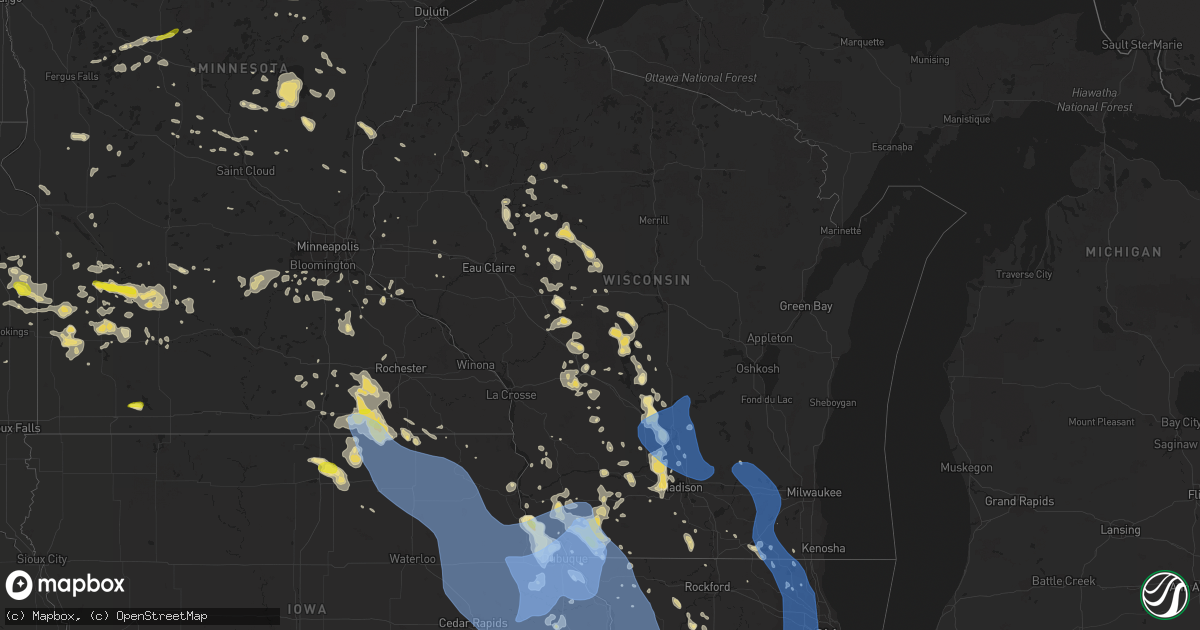
Hail Map in Wisconsin on June 30, 2019
Get this storm
June 30 map
$229
one time, instant access
Download today. No call, no setup
Keep the $229
Bought the map and want the full workflow? Apply the entire $229 to a subscription within 7 days. None of it is wasted.
Every map, not just this one
This buys you this map. Subscription and you get every map we run, in the markets you choose from a few cities to whole states to nationwide. Plus real-time alerts the moment a storm fires.
Contact data
Name, contact info, occupancy, even credit band for addresses in the footprint. You go from where it hit to who to call.
Become the source they trust
Unlimited branding weather history reports on demand. You already have the documented answer ready for the property owner, and you are the one who showed up with it.
Property data and RoofTrace estimates
Pull up any address you have got, its value and the exact code rules for that jurisdiction, straight from One Click Code. Then RoofTrace estimates the squares, pitch, and roof value, priced the way you price.
Storm reports in Wisconsin
Wisconsin
| Date | Description |
|---|---|
| 06/30/20195:54 PM CDT | Trees down. |
| 06/30/20195:38 PM CDT | Several trees and power lines down across the county. Hardest hit areas across southern half of county. 20...000 residents without power. Cuba city hit particularly har |
| 06/30/20195:35 PM CDT | Measured gust by the platteville awos. |
| 06/30/20195:35 PM CDT | Trees down. |
| 06/30/20194:11 PM CDT | Tree down on highway 171. Time estimated based on radar. |
| 06/30/20191:03 PM CDT | Trees down across the road. |
| 06/30/20191:03 PM CDT | Numerous large trees uprooted and snapped in half. Numerous power lines down. |
| 06/30/201912:53 PM CDT | Wind damaged a transformer in the area near ridgeview drive and county road b. |
| 06/30/201912:50 PM CDT | Several tree branches down. |
| 06/30/201912:40 PM CDT | Large tree limbs down. Estimated 60 mph gusts. |
| 06/30/201912:30 PM CDT | Large tree down. |
| 06/30/201912:28 PM CDT | Large branches snapped off. |
| 06/30/201912:25 PM CDT | Tree damage throughout the county. Delavan is one hard hit area. |
| 06/30/201912:25 PM CDT | Tree damage throughout the county. Fontana is one of the hard hit areas. |
| 06/30/201912:00 PM CDT | Large tree branch down. |
| 06/30/201912:00 PM CDT | Widespread wind damage in waukesha county especially in the oconomowoc area. |
| 06/30/201911:55 AM CDT | Two large tree branches down. |
| 06/30/201911:45 AM CDT | Widespread wind damage throughout the county particularly in the ixonia area. |
| 06/30/201911:42 AM CDT | Siding blown off of a house in ashippun. |
| 06/30/201911:40 AM CDT | . |
| 06/30/201911:35 AM CDT | Trees down. |
| 06/30/201911:35 AM CDT | Trees down across the area. |
| 06/30/201911:30 AM CDT | Hwy 26 large tree down blocking road. |
| 06/30/201911:25 AM CDT | Two young trees snapped at their base. |
| 06/30/201911:16 AM CDT | Scattered trees down with some being large. |
| 06/30/201911:00 AM CDT | Scattered trees down. |
| 06/30/201910:50 AM CDT | Widespread tress down. |
| 06/30/201910:40 AM CDT | Corrects previous tstm wnd dmg report from montello. Scattered trees down throughout the county. |
| 06/30/201910:40 AM CDT | Widespread trees down with some being large. |
| 06/30/201910:30 AM CDT | Scattered trees down with a few large trees. |
| 06/30/201910:30 AM CDT | Scattered trees down with a few large trees. |
| 06/30/201910:25 AM CDT | Wind branches down. Estimated 50-60mph gusts. |
| 06/30/201910:20 AM CDT | Corrects previous tstm wnd dmg report from lake delton. Scattered trees down with some being large. |
| 06/30/20199:25 AM CDT | 2-3 trees down. Delayed report. Time estimated. |
| 06/30/20197:21 AM CDT | At 1220 PM CDT, severe thunderstorms were located along a line extending from near Big Bend to near East Troy to near Como to Darien to near Clinton, moving southeast at 45 mph. HAZARD...60 mph wind gusts. SOURCE...Radar indicated. IMPACT...Expect damage to roofs, siding, and trees. Locations impacted include... Waukegan, North Chicago, Gurnee, Mundelein, Algonquin, McHenry, Belvidere, Vernon Hills, Woodstock, Zion, Loves Park, Grayslake, Libertyville, Lake Zurich, Round Lake, Antioch, Beach Park, Wauconda, Fox Lake and Barrington.Including the following interstates... I-90 between mile markers 38 and 60. I-94 between mile markers 1 and 16. I-294 between mile markers 1 and 16.This includes... Boone County Fairgrounds, Chain O Lakes State Park,College of Lake County, IL Beach State Park, Lake County ILFairgrounds, Mchenry County College, Mchenry County Fairgrounds,Moraine Hills State Park, and Six Flags Great America. |
| 06/30/20196:26 AM CDT | At 1126 AM CDT, severe thunderstorms were located along a line extending from near Campbellsport to near Lake Mills, moving southeast at 40 mph. HAZARD...60 mph wind gusts. SOURCE...Law enforcement. There have been numerous reports of tree damage and power outages. IMPACT...Expect damage to roofs, siding, and trees. Locations impacted include... Watertown, Whitewater, Hartford, Fort Atkinson, Jefferson, Delafield, Lake Mills, Waterloo, Wales, Okauchee Lake, Oconomowoc, Johnson Creek, Dousman, North Prairie, Palmyra, Lac La Belle, Lake Ripley, Lake Koshkonong, Ixonia and Rome. |
| 06/30/20195:48 AM CDT | At 1047 AM CDT, severe thunderstorms were located along a line extending from near Oshkosh to near Cross Plains, moving east at 45 mph. HAZARD...60 mph wind gusts and quarter size hail. SOURCE...Radar indicated. There have been reports of tree damage and power outages upstream. IMPACT...Hail damage to vehicles is expected. Expect wind damage to roofs, siding, and trees. Locations impacted include... Madison, Sun Prairie, Fitchburg, Watertown, Middleton, Beaver Dam, Stoughton, Waunakee, Waupun, Verona, Oregon, McFarland, Monona, Mount Horeb, Windsor, Mayville, Columbus, Marshall, Horicon and Sauk City.People attending The Columbus Baseball Tournament should seek safeshelter immediately! |
| 06/30/20195:12 AM CDT | At 1011 AM CDT, severe thunderstorms were located along a line extending from 9 miles north of Redgranite to 7 miles northwest of Wisconsin Dells, moving southeast at 30 mph. HAZARD...60 mph wind gusts and quarter size hail. SOURCE...Radar indicated. IMPACT...Hail damage to vehicles is expected. Expect wind damage to roofs, siding, and trees. Locations impacted include... Baraboo, Portage, Wisconsin Dells, Lake Wisconsin, Berlin, Lake Delton, Pardeeville, Randolph, Montello, Markesan, West Baraboo, Westfield, Princeton, Green Lake, Cambria, Lawrence, Packwaukee, Manchester, Wyocena and North Freedom. |
| 06/30/201912:54 AM CDT | At 553 PM CDT, severe thunderstorms were located along a line extending from near Argyle to St. Donatus, moving southeast at 45 mph. HAZARD...70 mph wind gusts. SOURCE...Trained spotters. IMPACT...Expect considerable tree damage. Damage is likely to mobile homes, roofs, and outbuildings. Locations impacted include... Freeport, Galena, Lena, Stockton, Warren, Hanover, Pearl City, Elizabeth, Shannon, Cedarville, Davis, Woodbine, Dakota, German Valley, Scales Mound, Apple River, Winslow, Rock City, Ridott and Council Hill. |
| 06/30/201912:31 AM CDT | At 530 PM CDT, severe thunderstorms were located along a line extending from near Dickeyville to near Hopkinton to near La Porte City, moving south at 45 mph. HAZARD...70 mph wind gusts and quarter size hail. SOURCE...Radar indicated. IMPACT...Hail damage to vehicles is expected. Expect considerable tree damage. Wind damage is also likely to mobile homes, roofs, and outbuildings. Locations impacted include... Cedar Rapids, Dubuque, Maquoketa, Anamosa, Vinton, Galena, Mechanicsville, Stanwood, Marion, Hiawatha, Mount Vernon, Monticello, Robins, Center Point, Bellevue, Cascade, Lisbon, Fairfax, Ely and East Dubuque.If you are at J and P Cycles in Anamosa you should seek safe shelterimmediately!This includes Interstate 380 between mile markers 13 and 47. |
| 06/30/201912:27 AM CDT | At 527 PM CDT, a severe thunderstorm was located over Platteville, moving southeast at 25 mph. HAZARD...60 mph wind gusts. SOURCE...Radar indicated. IMPACT...Expect damage to roofs, siding, and trees. Locations impacted include... Shullsburg, Belmont, Benton, New Diggings, Platte Mounds, Lead Mine and Leslie. |
| 06/29/201911:54 PM CDT | At 453 PM CDT, severe thunderstorms were located along a line extending from near Lancaster to 6 miles south of Elkader to near Hazleton, moving south at 45 mph. HAZARD...60 mph wind gusts and quarter size hail. SOURCE...Radar indicated. IMPACT...Hail damage to vehicles is expected. Expect wind damage to roofs, siding, and trees. Locations impacted include... Dubuque, Independence, Manchester, Galena, Asbury, Dyersville, Jesup, Epworth, East Dubuque, Farley, Peosta, Fairbank, Edgewood, Winthrop, Hazleton, Earlville, Hopkinton, Quasqueton, Lamont and Delhi.This includes Interstate 380 between mile markers 50 and 55. |
| 06/29/201911:31 PM CDT | At 431 PM CDT, severe thunderstorms were located along a line extending from McGregor to near Sumner, moving south at 50 mph. HAZARD...60 mph wind gusts. SOURCE...Radar indicated. IMPACT...Expect damage to roofs, siding, and trees. Severe thunderstorms will be near... Garnavillo around 440 PM CDT. Oelwein and Guttenberg around 450 PM CDT. Fairbank around 455 PM CDT.Other locations impacted by these severe thunderstorms includeMederville, Randalia, Highways 3 And 187, Turkey River, Bixby StatePark, Highway 13 And County C 24 and Fairview. |
| 06/29/201911:09 PM CDT | At 408 PM CDT, severe thunderstorms were located along a line extending from near Nora Springs to near Waukon to near Lansing, moving south at 35 mph. HAZARD...60 mph wind gusts. SOURCE...Radar indicated. IMPACT...Expect damage to roofs, siding, and trees. Severe thunderstorms will be near... Postville and Harpers Ferry around 420 PM CDT. Monona around 425 PM CDT. Rockford around 430 PM CDT. Prairie Du Chien and Marquette around 435 PM CDT. McGregor, Marble Rock and Farmersburg around 440 PM CDT.Other locations impacted by these severe thunderstorms includeVolney, Bradford, Nordness, Chickasaw, Giard, County Roads V 56 And B33 and Waucoma Campground. |
| 06/29/20198:02 PM CDT | At 101 PM CDT, severe thunderstorms were located along a line extending from near Union Grove to Lake Catherine to near Bull Valley to near Lakewood to near Belvidere, moving southeast at 40 mph. HAZARD...60 mph wind gusts. SOURCE...Trained weather spotters. IMPACT...Expect damage to roofs, siding, and trees. Locations impacted include... Chicago, Aurora, Naperville, Elgin, Waukegan, Cicero, Arlington Heights, Evanston, Schaumburg, Bolingbrook, Palatine, Skokie, Des Plaines, Berwyn, Mount Prospect, Wheaton, Hoffman Estates, Oak Park, Downers Grove and Glenview.Including the following interstates... I-55 between mile markers 270 and 278. I-88 between mile markers 118 and 140. I-90 between mile markers 22 and 40. I-94 between mile markers 1 and 50. I-290 between mile markers 1 and 28. I-294 between mile markers 1 and 50. I-355 between mile markers 15 and 30.This includes... Brookfield Zoo, Lincoln Park Zoo, LoyolaUniversity, Oakton Community College, Schaumburg Boomers Baseball,Triton College, Benedictine University, Chain O Lakes State Park,College of DuPage, College of Lake County, DuPage County Fairgrounds,Elgin Community College, Fermilab, Great Lakes Naval Training Center,Harper College, Hawthorne Park, IL Beach State Park, Kane CountyCougars Ballpark, Lake County IL Fairgrounds, Lake Forest College,Mchenry County College, Mchenry County Fairgrounds, Moraine HillsState Park, Morton Arboretum, Northeastern Illinois University,Northwestern University, Ravinia Music Festival, Six Flags GreatAmerica, Wheaton College, Wrigley Field, and North Central College. |
All States Impacted by Hail Map on June 30, 2019
Cities Impacted by Hail Map on June 30, 2019
- Shakopee, MN
- Jordan, MN
- Stockton, IL
- Hill City, SD
- Walnut Grove, MN
- Midkiff, TX
- Newark, IL
- Minooka, IL
- Channahon, IL
- Shorewood, IL
- Morris, IL
- Miller, SD
- Adams, MN
- Nashville, IN
- McCamey, TX
- Crane, TX
- Sebring, FL
- Argenta, IL
- Cerro Gordo, IL
- Bremen, ME
- Bristol, ME
- Cranston, RI
- West Warwick, RI
- Hope, RI
- Warwick, RI
- Johnston, RI
- East Greenwich, RI
- Kyle, SD
- Elkton, SD
- Ottertail, MN
- Richville, MN
- Gaylord, MN
- Cologne, MN
- Hamburg, MN
- Norwood Young America, MN
- Henderson, MN
- Glencoe, MN
- Green Isle, MN
- Plato, MN
- Arlington, MN
- Young America, MN
- Spencer, SD
- Middleboro, MA
- Kendall, WI
- Saint Joseph, IL
- New Richland, MN
- Waseca, MN
- Kansas, IL
- Gregory, SD
- Dallas, SD
- Burke, SD
- Winner, SD
- Hamill, SD
- Bloomington, IN
- Ellettsville, IN
- Lodi, WI
- Dane, WI
- Prairie Du Sac, WI
- Madison, WI
- Waunakee, WI
- Sauk City, WI
- Mount Horeb, WI
- Mazomanie, WI
- Verona, WI
- Middleton, WI
- Cross Plains, WI
- Hume, IL
- Metcalf, IL
- Lee, IL
- Aurora, IL
- Montgomery, IL
- Yorkville, IL
- Oswego, IL
- Sugar Grove, IL
- Plano, IL
- Big Rock, IL
- Bristol, IL
- Fairbanks, IN
- Shelburn, IN
- Wellington, IL
- Hoopeston, IL
- Lodge Grass, MT
- Cheyenne, WY
- Jasper, IN
- Walworth, WI
- Williams Bay, WI
- Fontana, WI
- Lake Geneva, WI
- Delavan, WI
- Otter, MT
- Orfordville, WI
- Imperial, TX
- Ashkum, IL
- Mattoon, IL
- Lance Creek, WY
- Big Timber, MT
- Scales Mound, IL
- Rewey, WI
- Bloomington, WI
- Mineral Point, WI
- Platteville, WI
- Benton, WI
- Shullsburg, WI
- Highland, WI
- Belmont, WI
- Livingston, WI
- Linden, WI
- Dodgeville, WI
- Fennimore, WI
- Mount Hope, WI
- Lancaster, WI
- Cuba City, WI
- Potosi, WI
- Darlington, WI
- Marengo, IL
- Lewellen, NE
- Arthur, NE
- Salem, IN
- Campbellsburg, IN
- West Point, KY
- Muldraugh, KY
- Lewisport, KY
- Wisconsin Rapids, WI
- Oakland, IL
- Garrison, MN
- Wahkon, MN
- Onamia, MN
- Red Wing, MN
- Sidney, NE
- Macon, IL
- Boody, IL
- Moweaqua, IL
- Brazil, IN
- Pekin, IN
- Borden, IN
- Campton, KY
- Russell, MN
- Tyler, MN
- Rossville, IL
- Williamsport, IN
- Hendricks, MN
- Evansville, WI
- Beloit, WI
- Brodhead, WI
- Cornell, WI
- Holcombe, WI
- Peetz, CO
- Mooresville, IN
- Montgomery, IN
- Fredericksburg, IN
- Verndale, MN
- Black River Falls, WI
- Platte, SD
- Seneca, IL
- Parmelee, SD
- Saint Francis, SD
- Sheridan, WY
- Camden, AR
- Lime Springs, IA
- Chester, IA
- Le Roy, MN
- Sparland, IL
- Henry, IL
- Varna, IL
- Lacon, IL
- Toluca, IL
- Weldona, CO
- Merrillan, WI
- Mason City, IA
- Manly, IA
- Pierz, MN
- Hillman, MN
- Onida, SD
- Fairfax, MN
- Franklin, MN
- Frankfort, KY
- Spearsville, LA
- Lamberton, MN
- Norwalk, WI
- Sparta, WI
- Tomah, WI
- Wilton, WI
- Rochdale, MA
- North Oxford, MA
- Auburn, MA
- Freedom, IN
- Coal City, IN
- White, SD
- Cannon Falls, MN
- Grover, CO
- Farmingville, NY
- Holtsville, NY
- Penfield, IL
- Loda, IL
- Ludlow, IL
- Cissna Park, IL
- Rankin, IL
- Potomac, IL
- Buckley, IL
- Paxton, IL
- Hardinsburg, IN
- Rice, MN
- Sauk Rapids, MN
- Springfield, KY
- Saint Catharine, KY
- Fort Morgan, CO
- Keenesburg, CO
- Roggen, CO
- Watertown, WI
- Jay Em, WY
- Fort Laramie, WY
- Bonfield, IL
- Kankakee, IL
- East Islip, NY
- Oakdale, NY
- Great River, NY
- Oregon, IL
- Chana, IL
- Ashton, IL
- Palm Bay, FL
- Melville, MT
- Newcastle, WY
- Seymour, IN
- Elizabethtown, IN
- Columbus, IN
- Seaforth, MN
- Vesta, MN
- Sacred Heart, MN
- Danube, MN
- Hanley Falls, MN
- Cottonwood, MN
- Olivia, MN
- Belview, MN
- Echo, MN
- Morton, MN
- Redwood Falls, MN
- Renville, MN
- Wood Lake, MN
- Wabasso, MN
- Salem, SD
- Winfred, SD
- Montrose, SD
- Marion, LA
- Lebanon, SD
- Mora, MN
- Ogilvie, MN
- Hanover, IN
- Nabb, IN
- Lexington, IN
- Hager City, WI
- Lead, SD
- Dubuque, IA
- Durango, IA
- Cassville, WI
- Holy Cross, IA
- Glen Haven, WI
- North Buena Vista, IA
- Wanblee, SD
- Interior, SD
- Kadoka, SD
- Wood Lake, NE
- Granite Falls, MN
- Gays Mills, WI
- Amana, IA
- Carbon, IN
- Rosedale, IN
- Reelsville, IN
- Bedford, IN
- Custer, SD
- Greencastle, IN
- Ideal, SD
- La Motte, IA
- Bellevue, IA
- Ruthton, MN
- Keystone, SD
- Siren, WI
- Charleston, IL
- Sterling City, TX
- Eagle Bend, MN
- Kimball, SD
- New York Mills, MN
- Sutton, MA
- Oxford, MA
- Belfry, KY
- Sidney, KY
- Austin, MN
- Kersey, CO
- Homer, IL
- Fairmount, IL
- Fithian, IL
- Big Lake, TX
- Brandt, SD
- Hinckley, MN
- Grantsburg, WI
- Pine City, MN
- Camp Douglas, WI
- Rockville, IN
- Cody, NE
- Nenzel, NE
- Kilgore, NE
- New Prague, MN
- Chrisman, IL
- Franktown, CO
- Castle Rock, CO
- Thorp, WI
- Greenwood, WI
- Clear Lake, SD
- Crow Agency, MT
- Vesper, WI
- Conrath, WI
- Madison, MN
- Toronto, SD
- Arco, MN
- Brookings, SD
- Minneota, MN
- Ivanhoe, MN
- Bruce, SD
- Ellsworth, NE
- Bingham, NE
- Elsie, NE
- Attica, IN
- Covington, IN
- West Lebanon, IN
- Realitos, TX
- Upton, WY
- Oxford, WI
- Endeavor, WI
- Orlando, FL
- Moore Haven, FL
- Clewiston, FL
- Athol, MA
- Petersham, MA
- Osage, WY
- Somerset, WI
- Holland, MN
- Lake Benton, MN
- Balaton, MN
- Woodstock, MN
- Springfield, MN
- Spring Green, WI
- Plain, WI
- Milford, IL
- Merriman, NE
- Whitman, NE
- Veteran, WY
- Waltham, MN
- Bohemia, NY
- Islip Terrace, NY
- Central Islip, NY
- Sayville, NY
- Brentwood, NY
- Islandia, NY
- Hauppauge, NY
- Islip, NY
- West Sayville, NY
- Reed Point, MT
- Freeport, MN
- Albany, MN
- Canby, MN
- Gary, SD
- Estelline, SD
- Astoria, SD
- Remer, MN
- Kimball, MN
- South Hamilton, MA
- Essex, MA
- Long Valley, SD
- Alvin, IL
- Danville, IL
- Georgetown, IL
- Cayuga, IN
- Hillsdale, IN
- Dana, IN
- Ridge Farm, IL
- Joliet, IL
- Plainfield, IL
- Elkhart, IL
- Lingle, WY
- Flat Lick, KY
- Barbourville, KY
- Nekoosa, WI
- Port Edwards, WI
- Hollis, NH
- Orleans, IN
- Ellsworth, WI
- Bay City, WI
- Glen Flora, WI
- Hardin, MT
- Hayward, MN
- Herrick, SD
- Finlayson, MN
- McGrath, MN
- Withee, WI
- Owen, WI
- Lublin, WI
- Fairbury, IL
- Adams, WI
- Friendship, WI
- Okabena, MN
- Merrimac, WI
- Portage, WI
- Baraboo, WI
- Lagrange, WY
- Orchard, CO
- Deer Creek, MN
- Henning, MN
- Norris, SD
- Wonewoc, WI
- Cazenovia, WI
- Suffolk, VA
- Herman, MN
- Briggsville, WI
- Grand Marsh, WI
- Wisconsin Dells, WI
- Hill City, MN
- Wadena, MN
- Sebeka, MN
- Hillpoint, WI
- Marshall, MN
- Bethany, IL
- Hastings, MN
- Valentine, NE
- Sleepy Eye, MN
- Morgan, MN
- Ellendale, MN
- Poland, IN
- Cloverdale, IN
- Spencer, IN
- Versailles, KY
- Danforth, IL
- Neillsville, WI
- Granton, WI
- Brooklyn, WI
- Centerpoint, IN
- Crest Hill, IL
- Elwood, IL
- Sarona, WI
- Birchwood, WI
- Frederic, WI
- Fenton, IL
- Morrison, IL
- Stoneham, CO
- Palisade, MN
- Mahomet, IL
- Fisher, IL
- Tracy, MN
- Wheatland, WY
- Bighorn, MT
- Grand Rapids, MN
- Forsyth, MT
- Ashland, MT
- Lame Deer, MT
- Billerica, MA
- Burlington, MA
- New Raymer, CO
- Williamsburg, VA
- Champaign, IL
- Thomasboro, IL
- Urbana, IL
- Sherrill, IA
- Brewster, MN
- Lakefield, MN
- Longville, MN
- West Union, IL
- Birney, MT
- Hammond, IL
- Shoals, IN
- Loogootee, IN
- Eastman, WI
- Wilmington, IL
- Elroy, WI
- Sidell, IL
- Osage, IA
- Marseilles, IL
- Sheridan, IL
- Torrington, WY
- Warrens, WI
- Hayfield, MN
- Dorchester, WI
- Abbotsford, WI
- Curtiss, WI
- Colby, WI
- Spencer, WI
- Unity, WI
- Vineyard Haven, MA
- Edgartown, MA
- Prior Lake, MN
- Lakeville, MN
- Manville, WY
- Lusk, WY
- Dexter, MN
- Lyle, MN
- Brownsdale, MN
- Rose Creek, MN
- McIntire, IA
- Blooming Prairie, MN
- Riceville, IA
- Elkton, MN
- Taopi, MN
- Sargeant, MN
- Stacyville, IA
- Dodge Center, MN
- Ferryville, WI
- Soldiers Grove, WI
- Mount Morris, IL
- Leaf River, IL
- German Valley, IL
- Bird Island, MN
- Belle Plaine, MN
- Alpena, SD
- Racine, MN
- Albert Lea, MN
- Grand Meadow, MN
- Saint Ansgar, IA
- Claremont, MN
- Stewartville, MN
- Glenville, MN
- Little Cedar, IA
- Kasson, MN
- Mitchell, IN
- Sullivan, IN
- Farmersburg, IN
- Elizabeth, IN
- Fort Knox, KY
- Corydon, IN
- Laconia, IN
- Lancaster, KY
- Hanlontown, IA
- Kensett, IA
- Wood, SD
- Presho, SD
- Pukwana, SD
- Hillsboro, WI
- Haxtun, CO
- Fleming, CO
- Gann Valley, SD
- Wyoming, IL
- Commack, NY
- Smithtown, NY
- South Wayne, WI
- Aitkin, MN
- Webster, MN
- Witten, SD
- White River, SD
- Mission, SD
- Okreek, SD
- Harmon, IL
- Waldoboro, ME
- Dawson, MN
- Ramsey, IN
- Belle Plaine, IA
- Hampton, AR
- Brainerd, MN
- Menomonie, WI
- Boulder, CO
- Nederland, CO
- Billings, MT
- Solsberry, IN
- Bloomfield, IN
- Junction, TX
- Sparks, NE
- Isle, MN
- Nerstrand, MN
- Kenyon, MN
- Lillie, LA
- Chebanse, IL
- Herscher, IL
- Swatara, MN
- Outing, MN
- East Northport, NY
- Ronkonkoma, NY
- Northport, NY
- Kings Park, NY
- Colome, SD
- Akron, CO
- Willard, WI
- Marshfield, WI
- Chili, WI
- San Diego, TX
- Stitzer, WI
- Ridgefield, CT
- Danbury, CT
- Chugwater, WY
- Mattapoisett, MA
- Amelia Court House, VA
- Rapid City, SD
- New Richmond, WI
- Hudson, WI
- Arkdale, WI
- Babcock, WI
- Pittsville, WI
- Necedah, WI
- Clear Lake, IA
- Nora Springs, IA
- Rock Falls, IL
- Goodwin, SD
- Otisco, IN
- Marysville, IN
- Clifton, IL
- Cabery, IL
- Savage, MN
- Sundance, WY
- Holmes, NY
- Patterson, NY
- Brewster, NY
- Redding, CT
- Cascade, IA
- Epworth, IA
- Bernard, IA
- Meriden, WY
- Burns, WY
- Weston, CT
- Gillette, WY
- Lawrenceburg, KY
- Loyal, WI
- Hebron, IL
- Richmond, IL
- Wonder Lake, IL
- Guttenberg, IA
- Madison, IN
- Spragueville, IA
- Maquoketa, IA
- Andrew, IA
- Arlington, SD
- Marshall, IL
- Leopold, IN
- Sulphur, IN
- English, IN
- Leavenworth, IN
- Boston, KY
- Putnamville, IN
- Fillmore, IN
- Jolo, WV
- Carson, VA
- Dinwiddie, VA
- Stanley, WI
- Ree Heights, SD
- Milton, NY
- Prophetstown, IL
- Clarkfield, MN
- Taunton, MN
- Harmony, MN
- Paragon, IN
- Tony, WI
- McGregor, IA
- Harpers Ferry, IA
- Monona, IA
- Browerville, MN
- Harris, MN
- North Branch, MN
- Milan, MN
- Paris, IL
- Ashmore, IL
- Brocton, IL
- Strasburg, IL
- Serena, IL
- Gilman, IL
- Onarga, IL
- Armstrong, IL
- Tinley Park, IL
- Milaca, MN
- Foreston, MN
- Rockton, IL
- Coatesville, IN
- Dubois, IN
- Haynesville, LA
- Eros, LA
- Calhoun, LA
- West Monroe, LA
- Pine Bluffs, WY
- Ohio, IL
- Hyden, KY
- Scenic, SD
- Marshall, IN
- Bloomingdale, IN
- Little Falls, MN
- Peosta, IA
- Farley, IA
- Slayton, MN
- Garvin, MN
- Waveland, IN
- Strong, AR
- El Dorado, AR
- Nokomis, IL
- Cannelton, IN
- Derby, IN
- Kennan, WI
- Owatonna, MN
- Chamberlain, SD
- Steward, IL
- Wiggins, CO
- La Place, IL
- Castlewood, SD
- Okeechobee, FL
- Palmyra, IN
- Hoffman, MN
- Snyder, CO
- Otis, CO
- Chidester, AR
- Farmerville, LA
- Monroe, LA
- Prudence Island, RI
- Watseka, IL
- Ottawa, IL
- Westport, CT
- Wilton, CT
- Verona, IL
- Mazon, IL
- Gifford, IL
- Ogden, IL
- Elburn, IL
- Geneva, IL
- Leola, AR
- Oakwood, IL
- Lost Nation, IA
- Delmar, IA
- Orange Grove, TX
- Farwell, MN
- Welch, MN
- Lynd, MN
- Milroy, MN
- Springview, NE
- Centereach, NY
- Rawlings, VA
- Hector, MN
- Lake Wilson, MN
- New Washington, IN
- Oak Park, MN
- Sanborn, MN
- Arena, WI
- Barneveld, WI
- Blue Mounds, WI
- Carpenter, WY
- New Auburn, WI
- Jim Falls, WI
- Bruce, WI
- Bloomer, WI
- Glendo, WY
- Fulton, IL
- Albany, IL
- Erie, IL
- Clinton, IA
- Mansfield, IL
- Shongaloo, LA
- Tilton, IL
- Buffalo Lake, MN
- Braceville, IL
- Coal City, IL
- Braidwood, IL
- Kingman, IN
- Darien, WI
- Avalon, WI
- Gratiot, WI
- Ortonville, MN
- Clinton, MN
- Harrisburg, NE
- Pine Island, MN
- Byron, MN
- Lake Villa, IL
- Antioch, IL
- Tuthill, SD
- Allerton, IL
- Crescent City, IL
- Buckingham, IL
- Vero Beach, FL
- Yoder, WY
- Hulett, WY
- Grand Mound, IA
- Cambridge, MN
- Hampton, MN
- Lone Rock, WI
- Avoca, WI
- Sterling, CO
- Nicholasville, KY
- Wilmore, KY
- Kilkenny, MN
- Coyanosa, TX
- Boyd, MN
- Davenport, IA
- Bradford, IL
- Gibson City, IL
- Evanston, IN
- Lamar, IN
- Grandview, IN
- Staples, MN
- Pearl City, IL
- Rantoul, IL
- Burtrum, MN
- Shrewsbury, MA
- Milltown, IN
- Depauw, IN
- Cavour, SD
- Warren, IL
- Nora, IL
- Lena, IL
- Mathis, TX
- Northfield, MN
- Winchester, KY
- Saint Lawrence, SD
- Garnavillo, IA
- New Vienna, IA
- Colesburg, IA
- Morris, MN
- Hancock, MN
- Tuscola, IL
- Custer, MT
- Loganville, WI
- Fort Thompson, SD
- Poynette, WI
- Austin, IN
- Battle Lake, MN
- Martinsville, IN
- Monrovia, IN
- Lerna, IL
- Emily, MN
- Strandburg, SD
- Hyannis, NE
- Elmwood, WI
- Harrodsburg, KY
- Carver, MN
- Colman, SD
- Flandreau, SD
- Marion, MA
- Long Prairie, MN
- Swanville, MN
- Lucan, MN
- Coxs Creek, KY
- Plympton, MA
- Halifax, MA
- Hancock, WI
- Palestine, IL
- Newman, IL
- Villa Grove, IL
- Murdock, IL
- Camargo, IL
- Richmond, KY
- Hurley, VA
- Hawkins, WI
- Decorah, IA
- Bowlus, MN
- Royalton, MN
- Appleton, MN
- Crystal Lake, IL
- Mchenry, IL
- Island Lake, IL
- Lovington, IL
- Decatur, IL
- Crookston, NE
- Longview, IL
- Sidney, IL
- Broadlands, IL
- Owaneco, IL
- Pana, IL
- Greenup, IL
- Dalton City, IL
- Scottsburg, IN
- North Freedom, WI
- Eldridge, IA
- Long Grove, IA
- Margarettsville, NC
- Donnelly, MN
- Lanark, IL
- Mount Carroll, IL
- Bowling Green, IN
- Busy, KY
- Joice, IA
- Rockford, IA
- Fertile, IA
- Sauk Centre, MN
- Belvidere, SD
- Grafton, IA
- Northwood, IA
- Carpenter, IA
- Plymouth, IA
- Branchville, IN
- Toulon, IL
- Medford, WI
- Geneseo, IL
- Pardeeville, WI
- Alden, MN
- Hartland, MN
- Bismarck, IL
- Montezuma, IN
- Ladysmith, WI
- Gilman, WI
- Mount Pulaski, IL
- Emington, IL
- Goldsmith, TX
- Dalton, NE
- Lebanon Junction, KY
- Ghent, MN
- Baldwin, IA
- Charlton, MA
- Trafalgar, IN
- Clermont, KY
- Shepherdsville, KY
- Mount Washington, KY
- McKenney, VA
- Eldena, IL
- Dixon, IL
- Fillmore, IL
- Paoli, IN
- Barronett, WI
- Deforest, WI
- Cadott, WI
- Boyd, WI
- Lodgepole, NE
- Crook, CO
- Bagley, WI
- Dix, NE
- Indianola, IL
- Unionville, IN
- Morgantown, IN
- Faribault, MN
- Dennison, MN
- Mundelein, IL
- Grayslake, IL
- Readstown, WI
- Amherst, NH
- Milford, NH
- Janesville, WI
- Underwood, MN
- Woonsocket, SD
- Huron, SD
- Artesian, SD
- Wessington Springs, SD
- Milton, WI
- Bangs, TX
- Santa Anna, TX
- Avon, MN
- Holdingford, MN
- Wallace, NE
- Humboldt, IL
- West Baden Springs, IN
- Boswell, IN
- Bardstown, KY
- Elko New Market, MN
- Farmington, MN
- Pierre, SD
- Salem, WI
- West Terre Haute, IN
- Deputy, IN
- Rosemount, MN
- Wauzeka, WI
- Greene, IA
- Lake Placid, FL
- Fellsmere, FL
- Eau Galle, WI
- Colfax, IL
- Cropsey, IL
- Crewe, VA
- Hazel Green, WI
- Stafford Springs, CT
- Somers, CT
- Bainbridge, IN
- Sheldon, WI
- Wessington, SD
- Merino, CO
- Freeport, IL
- Shannon, IL
- Bushnell, NE
- Downing, WI
- Knapp, WI
- Boyceville, WI
- Clarissa, MN
- Stacy, MN
- Gravel Switch, KY
- Cresco, IA
- Poughquag, NY
- Gays, IL
- Clay City, IN
- Cannelburg, IN
- Grey Eagle, MN
- French Lick, IN
- Gray, KY
- Corbin, KY
- Rochelle, IL
- Athens, IL
- Greenview, IL
- Middletown, IL
- Wall, SD
- Galena, IL
- Taylorsville, KY
- Star Prairie, WI
- Ford, VA
- Lowry, MN
- Starbuck, MN
- Spring Valley, MN
- Ostrander, MN
- Worthington, IN
- Stilesville, IN
- Chaska, MN
- Bristow, IN
- Mcgregor, MN
- Sartell, MN
- Saint Stephen, MN
- Mt Zion, IL
- Mertzon, TX
- Birdseye, IN
- Stewart, MN
- East Troy, WI
- Fairchild, WI
- Arlington, WI
- Fairfield, CT
- Sandwich, IL
- Romeoville, IL
- Essex, IL
- Manhattan, IL
- Millington, IL
- Lockport, IL
- Savanna, IL
- Barrington, IL
- Wauconda, IL
- Wedron, IL
- Brownwood, TX
- Bena, MN
- Deer River, MN
- Hopewell Junction, NY
- Hawk Springs, WY
- Westborough, MA
- Northborough, MA
- Oshkosh, NE
- Ashby, NE
- Saint Xavier, MT
- Greycliff, MT
- Broadus, MT
- Morrisonville, WI
- Dalton, WI
- Cambria, WI
- Deerfield, WI
- Rio, WI
- Waterloo, WI
- Sun Prairie, WI
- Marshall, WI
- Cottage Grove, WI
- Montello, WI
- Columbus, WI
- Reedsburg, WI
- Windsor, WI
- Wyocena, WI
- Edwardsport, IN
- Patoka, IN
- Webster, KY
- La Grange, IL
- Lafayette, IN
- Otterbein, IN
- Dundee, IL
- Momence, IL
- Terre Haute, IN
- Plainville, IN
- Ladoga, IN
- Fox River Grove, IL
- Libertyville, IL
- Princeton, IN
- Glendale Heights, IL
- Owensboro, KY
- Pine Village, IN
- Lombard, IL
- Fowler, IN
- Caneyville, KY
- Lowell, IN
- Mount Prospect, IL
- Hutsonville, IL
- Flat Rock, IL
- Templeton, IN
- Norman, IN
- Collison, IL
- Nashotah, WI
- Lisle, IL
- Petersburg, IN
- Tennyson, IN
- Hanover Park, IL
- Fort Branch, IN
- Perrysville, IN
- West York, IL
- Universal, IN
- Palos Park, IL
- Garfield, KY
- Sheldon, IL
- Summit Argo, IL
- Philo, IL
- Olaton, KY
- Big Clifty, KY
- Washington, IN
- Goodland, IN
- Okauchee, WI
- Merom, IN
- Eastview, KY
- Knightsville, IN
- Hinsdale, IL
- Evansville, IN
- West Chicago, IL
- New Market, IN
- Scotland, IN
- Oconomowoc, WI
- Medora, IN
- Clinton, IN
- Park Forest, IL
- Chandler, IN
- Oaktown, IN
- Romney, IN
- Elberfeld, IN
- Carpentersville, IL
- Trevor, WI
- Savoy, IL
- Beaverville, IL
- New Richmond, IN
- Grant Park, IL
- Santa Claus, IN
- Gosport, IN
- Villa Park, IL
- Earl Park, IN
- Pewaukee, WI
- Ambia, IN
- Monroe City, IN
- Hymera, IN
- Wingate, IN
- Manteno, IL
- Pembroke Township, IL
- West Lafayette, IN
- Iroquois, IL
- Waynetown, IN
- Casey, IL
- Newburgh, IN
- Westville, IL
- Grantsburg, IN
- Cynthiana, IN
- Pimento, IN
- Henning, IL
- Cary, IL
- Payneville, KY
- Sandborn, IN
- Hillsboro, IN
- Stendal, IN
- Darien, IL
- Willowbrook, IL
- Franklin Park, IL
- Waukesha, WI
- Fordsville, KY
- Holland, IN
- Twin Lakes, WI
- Jasonville, IN
- Haubstadt, IN
- Winfield, IL
- Schaumburg, IL
- Ringwood, IL
- Harmony, IN
- Remington, IN
- Genoa City, WI
- Palatine, IL
- Monee, IL
- Oak Brook, IL
- Justice, IL
- Russellville, IN
- Dugger, IN
- Lake Forest, IL
- Battletown, KY
- Sullivan, WI
- Burlington, WI
- Otwell, IN
- Coalmont, IN
- Annapolis, IL
- Prospect Heights, IL
- Williams, IN
- Mokena, IL
- McDaniels, KY
- Crane, IN
- Vallonia, IN
- Lincoln City, IN
- Wheeling, IL
- New Goshen, IN
- Roachdale, IN
- Rhodelia, KY
- Glenview, IL
- Guston, KY
- Union Star, KY
- Taswell, IN
- New Salisbury, IN
- Calhoun, KY
- Bartlett, IL
- Reed, KY
- Ragsdale, IN
- Robinson, IL
- Springfield, WI
- Wayne, IL
- Stone Park, IL
- Sadorus, IL
- Saint Anne, IL
- Westview, KY
- Hawesville, KY
- Catlin, IL
- Boonville, IN
- Owensville, IN
- Mukwonago, WI
- Spottsville, KY
- Roselle, IL
- Mauckport, IN
- Horse Branch, KY
- Poseyville, IN
- Lincolnshire, IL
- Westphalia, IN
- Wheaton, IL
- Deerfield, IL
- Elk Grove Village, IL
- Muncie, IL
- Saint Francisville, IL
- Lawrenceville, IL
- Hartford, KY
- Lake Zurich, IL
- Melrose Park, IL
- Wales, WI
- Naperville, IL
- Bensenville, IL
- Vermilion, IL
- Custer, KY
- Dousman, WI
- New Lenox, IL
- Ingleside, IL
- Redmon, IL
- Wheatland, IN
- Mecca, IN
- Brandenburg, KY
- Spurgeon, IN
- Freelandville, IN
- Quincy, IN
- Woodstock, IL
- Downers Grove, IL
- Dundee, KY
- Wood Dale, IL
- Harned, KY
- Owensburg, IN
- Carol Stream, IL
- Mount Vernon, IN
- Bolingbrook, IL
- Oxford, IN
- Vine Grove, KY
- Broadview, IL
- Whitesville, KY
- Wilmot, WI
- Westchester, IL
- Huntingburg, IN
- Velpen, IN
- Martinton, IL
- Newberry, IN
- Western Springs, IL
- Richton Park, IL
- Arlington Heights, IL
- Willow Springs, IL
- Winslow, IN
- Tolono, IL
- Martinsville, IL
- Westfield, IL
- Celestine, IN
- Palmyra, WI
- Lyons, IN
- Algonquin, IL
- Union Hill, IL
- Addison, IL
- La Grange Park, IL
- Maywood, IL
- Lewis, IN
- Troy, IN
- Gentryville, IN
- Bicknell, IN
- Hindsboro, IL
- Hillside, IL
- Schiller Park, IL
- Henderson, KY
- Carlisle, IN
- Rolling Meadows, IL
- North Prairie, WI
- Elmhurst, IL
- Saint Anthony, IN
- Cloverport, KY
- Oolitic, IN
- Pesotum, IL
- Switz City, IN
- Chrisney, IN
- Glen Ellyn, IL
- Brook, IN
- State Line, IN
- Medinah, IL
- Hardinsburg, KY
- Ashippun, WI
- Stockland, IL
- Rockport, IN
- Ixonia, WI
- Reynolds Station, KY
- Veedersburg, IN
- Des Plaines, IL
- Staunton, IN
- Lebanon, WI
- Dennison, IL
- Streamwood, IL
- Arcola, IL
- Aroma Park, IL
- Brookfield, IL
- Clarendon Hills, IL
- Tell City, IN
- Odon, IN
- Marengo, IN
- Linton, IN
- Ferdinand, IN
- Mellott, IN
- Wadesville, IN
- Richland, IN
- Reddick, IL
- Livermore, KY
- Leitchfield, KY
- Eagle, WI
- Elgin, IL
- Elnora, IN
- Berkeley, IL
- Dale, IN
- Allendale, IL
- Oakland City, IN
- Maceo, KY
- Westmont, IL
- Frankfort, IL
- Vernon Hills, IL
- Heltonville, IN
- Saint Meinrad, IN
- Round Lake, IL
- Lemont, IL
- Beecher, IL
- Decker, IN
- Eckerty, IN
- Orland Park, IL
- Robards, KY
- Morocco, IN
- Palos Hills, IL
- Irvington, KY
- Papineau, IL
- Woodridge, IL
- Donovan, IL
- Central, IN
- Cecilia, KY
- Fox Lake, IL
- Rome, IN
- Riley, IN
- Spring Grove, IL
- Rineyville, KY
- Crete, IL
- Stinesville, IN
- Ekron, KY
- Peotone, IL
- Lynnville, IN
- Bruceville, IN
- Hazleton, IN
- Lake Village, IN
- Tunnelton, IN
- Alamo, IN
- Hartland, WI
- Avoca, IN
- Philpot, KY
- Warrenville, IL
- Hoffman Estates, IL
- Bloomingdale, IL
- Bridgeton, IN
- Dewey, IL
- Bourbonnais, IL
- Itasca, IL
- Bradley, IL
- Northbrook, IL
- Stephensport, KY
- Francisco, IN
- Buffalo Grove, IL
- Kentland, IN
- Hickory Hills, IL
- Homer Glen, IL
- Elkhorn, WI
- Crawfordsville, IN
- Falls Of Rough, KY
- University Park, IL
- Westpoint, IN
- Royal, IL
- Schnellville, IN
- Cory, IN
- Hudson, KY
- Patricksburg, IN
- Bellwood, IL
- Springville, IN
- Delafield, WI
- Helenville, WI
- Newtown, IN
- Vincennes, IN
- Utica, KY
- Saint Croix, IN
- Matteson, IL
- Whitewater, WI
- Arlington, IA
- Mineral, IL
- Ophiem, IL
- Woodhull, IL
- Anamosa, IA
- Manlius, IL
- Plainfield, IA
- Walnut, IL
- Dixon, IA
- Center Junction, IA
- New Liberty, IA
- Floyd, IA
- Hanover, IL
- Spillville, IA
- Teeds Grove, IA
- Rock Island, IL
- Fredericksburg, IA
- Blue Grass, IA
- Dahinda, IL
- Oelwein, IA
- Le Claire, IA
- Tipton, IA
- Alta Vista, IA
- Altona, IL
- Robins, IA
- Clermont, IA
- Calmar, IA
- Urbana, IA
- Sabula, IA
- Earlville, IA
- Oxford Junction, IA
- Princeton, IA
- Coggon, IA
- Galesburg, IL
- Miles, IA
- Polo, IL
- Oneida, IL
- Victoria, IL
- Stanley, IA
- Rio, IL
- Waucoma, IA
- Kieler, WI
- Worthington, IA
- Bettendorf, IA
- Hopkinton, IA
- Postville, IA
- Carbon Cliff, IL
- Cedar Rapids, IA
- Andover, IL
- Masonville, IA
- New Bedford, IL
- Buda, IL
- Wilton, IA
- Camanche, IA
- Mount Vernon, IA
- Fairbank, IA
- New Windsor, IL
- Cordova, IL
- Laura, IL
- Williamsfield, IL
- Ridgeway, IA
- McCausland, IA
- Elizabeth, IL
- Wataga, IL
- Lowden, IA
- Speer, IL
- Saint Lucas, IA
- Aurora, IA
- Apple River, IL
- Ely, IA
- Bishop Hill, IL
- Charles City, IA
- Sterling, IL
- Shellsburg, IA
- Marion, IA
- Ossian, IA
- Jesup, IA
- Volga, IA
- Pleasant Valley, IA
- Dunlap, IL
- Cambridge, IL
- Garber, IA
- Preston, IA
- Wyanet, IL
- Durant, IA
- Luxemburg, IA
- Delaware, IA
- Mechanicsville, IA
- Lawler, IA
- East Moline, IL
- Putnam, IL
- Goose Lake, IA
- Port Byron, IL
- Knoxville, IL
- Low Moor, IA
- Deer Grove, IL
- Brandon, IA
- Castalia, IA
- Neponset, IL
- Wyoming, IA
- Silvis, IL
- Martelle, IA
- Alpha, IL
- Springville, IA
- Calamus, IA
- Walcott, IA
- Delhi, IA
- Orchard, IA
- Readlyn, IA
- Forreston, IL
- Annawan, IL
- Ionia, IA
- Lisbon, IA
- Vinton, IA
- Dickeyville, WI
- Clarence, IA
- Sherrard, IL
- Onslow, IA
- New Hampton, IA
- Montfort, WI
- Brimfield, IL
- Osco, IL
- Nashua, IA
- Elmwood, IL
- Bryant, IA
- Elma, IA
- Ryan, IA
- Monmouth, IA
- West Union, IA
- Edelstein, IL
- Wheatland, IA
- Frederika, IA
- Sheffield, IL
- Lyndon, IL
- Princeville, IL
- Maynard, IA
- De Witt, IA
- Lamont, IA
- Westgate, IA
- Manchester, IA
- Rapids City, IL
- Independence, IA
- Solon, IA
- Colona, IL
- Chillicothe, IL
- Wadena, IA
- East Dubuque, IL
- Morley, IA
- Hawkeye, IA
- Stanwood, IA
- Orion, IL
- Milledgeville, IL
- Thomson, IL
- Olin, IA
- Hiawatha, IA
- Hampton, IL
- Palo, IA
- Fayette, IA
- Central City, IA
- Greeley, IA
- Dyersville, IA
- Welton, IA
- Alburnett, IA
- Waverly, IA
- Elkport, IA
- Center Point, IA
- Sumner, IA
- Protivin, IA
- Kent, IL
- Milan, IL
- Lynn Center, IL
- Edgewood, IA
- Monticello, IA
- Charlotte, IA
- Hillsdale, IL
- Princeton, IL
- Elkader, IA
- Randalia, IA
- Stockton, IA
- Dundee, IA
- Winthrop, IA
- Oran, IA
- Strawberry Point, IA
- Langworthy, IA
- Elgin, IA
- Bennett, IA
- Zwingle, IA
- Tiskilwa, IL
- Donahue, IA
- Colwell, IA
- Kewanee, IL
- Chadwick, IL
- Atkinson, IL
- Hazleton, IA
- Rowley, IA
- Fort Atkinson, IA
- Quasqueton, IA
- Tripoli, IA
- Moline, IL
- Walker, IA
- Coal Valley, IL
- Tampico, IL
- Galva, IL
- Toddville, IA
- Hooppole, IL
- La Fayette, IL
- Prairieburg, IA


