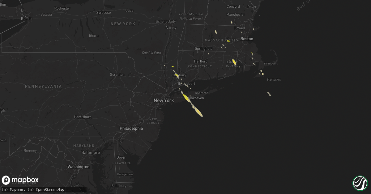
Hail Map on June 30, 2019
Get this storm
June 30 map
$229
one time, instant access
Download today. No call, no setup
Keep the $229
Bought the map and want the full workflow? Apply the entire $229 to a subscription within 7 days. None of it is wasted.
Every map, not just this one
This buys you this map. Subscription and you get every map we run, in the markets you choose from a few cities to whole states to nationwide. Plus real-time alerts the moment a storm fires.
Contact data
Name, contact info, occupancy, even credit band for addresses in the footprint. You go from where it hit to who to call.
Become the source they trust
Unlimited branding weather history reports on demand. You already have the documented answer ready for the property owner, and you are the one who showed up with it.
Property data and RoofTrace estimates
Pull up any address you have got, its value and the exact code rules for that jurisdiction, straight from One Click Code. Then RoofTrace estimates the squares, pitch, and roof value, priced the way you price.
States Impacted by Hail Map on June 30, 2019
Storm reports
New York
| Date | Description |
|---|---|
| 06/30/20193:43 PM CDT | Wires brought down on west neck road |
| 06/30/20192:50 PM CDT | Large tree down at sayville middle school |
| 06/30/20192:45 PM CDT | Downed trees and power lines on townline road |
| 06/30/20192:30 PM CDT | Large tree down on sylvan road. |
| 06/30/20192:30 PM CDT | Multiple large trees down on rhoda avenue |
| 06/30/20192:10 PM CDT | Downed tree on ny 231 northbound in the area of hunter avenue. Right lane closed. |
| 06/30/20192:05 PM CDT | Trees down on elder drive and cottonwood drive |
| 06/30/20192:00 PM CDT | Large tree down on wensley lane |
| 06/30/20191:56 PM CDT | Large tree branches down on vail street near route 111. |
| 06/30/20191:56 PM CDT | Trees and power lines down on campbell lane |
| 06/30/20191:55 PM CDT | Downed tree on northern state parkway westbound between exit 43- commack road and exit 42n-ny231. |
| 06/30/20191:55 PM CDT | Large tree down on locust avenue and brooktreet court |
| 06/30/20191:55 PM CDT | A thunderstorm wind gust of 53 knots was measured |
| 06/30/20191:55 PM CDT | Tree down in front of islip town hall on nassau avenue |
| 06/30/20191:52 PM CDT | Tree down blocking craig road near connectquot avenue. |
| 06/30/20191:50 PM CDT | Trees snapped and uprooted on thorn street |
| 06/30/20191:50 PM CDT | Multiple trees and wires down from around the bay shore area east through oakdale. |
| 06/30/20191:50 PM CDT | Downed tree on ny 231 northbound in the area of hunter avenue. Right lane closed. |
| 06/30/20191:50 PM CDT | Large tree down at sayville middle school |
| 06/30/20191:50 PM CDT | Large tree down into home on alkier street. |
| 06/30/20191:50 PM CDT | A local report indicates 1.00 inch wind near 1 N ISLIP |
| 06/30/20191:48 PM CDT | 22 inch diameter tree snapped about 25 ft above the ground on sunny lane |
| 06/30/20191:48 PM CDT | Large tree limbs and branches down on oakland street |
| 06/30/20191:48 PM CDT | Trees down on stanwich road |
| 06/30/20191:47 PM CDT | A local report indicates 62 MPH wind near BAY SHORE |
| 06/30/20191:46 PM CDT | A local report indicates 59 MPH wind near 1 WSW SOUTH SETAUKET |
| 06/30/20191:45 PM CDT | Large tree branches down. |
| 06/30/20191:45 PM CDT | Large tree branches down. |
| 06/30/20191:45 PM CDT | Multiple trees down on soma lane |
| 06/30/20191:45 PM CDT | Downed trees and power lines on townline road |
| 06/30/20191:40 PM CDT | Multiple large trees down on rhoda avenue |
| 06/30/20191:40 PM CDT | Trees down on elder drive and cottonwood drive |
| 06/30/20191:40 PM CDT | Large tree down on ketay drive n |
| 06/30/20191:40 PM CDT | Trees down on kenneth avenue |
| 06/30/20191:40 PM CDT | Large tree down on bogart street between evergreen avenue and depot road |
| 06/30/20191:35 PM CDT | Multiple trees and wires down from northport to commack. |
| 06/30/20191:32 PM CDT | Trees and power lines down. |
| 06/30/201912:50 PM CDT | A local report indicates 1.00 inch wind near 1 N MILLTOWN |
| 06/30/201912:19 PM CDT | A local report indicates 1.00 inch wind near 3 N POUGHQUAG |
| 06/30/201912:05 PM CDT | Trees and wires down on traver rd causing power outage |
| 06/30/201911:53 AM CDT | Trees down route 20 |
| 06/30/20197:19 AM CDT | At 1219 PM EDT, a severe thunderstorm was located over Mount Sinai, or near Port Jefferson, moving southeast at 35 mph. HAZARD...60 mph wind gusts. SOURCE...Radar indicated. IMPACT...Expect damage to trees and power lines. This severe thunderstorm will be near... Rocky Point around 1225 PM EDT. Medford and Middle Island around 1230 PM EDT. Wading River and Yaphank around 1235 PM EDT. Shirley and Manorville around 1240 PM EDT. Center Moriches around 1245 PM EDT. |
| 06/29/201911:36 PM CDT | At 435 PM EDT, a severe thunderstorm was located over Shelter Island, or near Sag Harbor, moving south at 40 mph. HAZARD...60 mph wind gusts and penny size hail. SOURCE...Radar indicated. IMPACT...Expect damage to trees and power lines. This severe thunderstorm will be near... Bridgehampton around 455 PM EDT. Southampton and East Hampton around 500 PM EDT. |
| 06/29/20199:34 PM CDT | At 234 PM EDT, a severe thunderstorm was located over Northport, moving southeast at 55 mph. HAZARD...60 mph wind gusts and quarter size hail. SOURCE...Radar indicated. IMPACT...Minor hail damage to vehicles is possible. Expect wind damage to trees and power lines. This severe thunderstorm will be near... Brentwood and Deer Park around 245 PM EDT. Islip and Ronkonkoma around 250 PM EDT. Patchogue and Sayville around 255 PM EDT. |
| 06/29/20198:58 PM CDT | At 157 PM EDT, a severe thunderstorm was located near Bethel, or near Danbury, moving southeast at 45 mph. HAZARD...60 mph wind gusts and quarter size hail. SOURCE...Radar indicated. IMPACT...Minor hail damage to vehicles is possible. Expect wind damage to trees and power lines. This severe thunderstorm will be near... New Canaan and Wilton around 205 PM EDT. Weston around 210 PM EDT. Norwalk and Westport around 215 PM EDT. Bridgeport and Fairfield around 220 PM EDT. |
| 06/29/20198:33 PM CDT | At 133 PM EDT, a severe thunderstorm was located near Lake Carmel, moving south at 40 mph. HAZARD...60 mph wind gusts and quarter size hail. SOURCE...Radar indicated. IMPACT...Minor hail damage to vehicles is possible. Expect wind damage to trees and power lines. This severe thunderstorm will be near... New Fairfield around 140 PM EDT. Carmel around 150 PM EDT. Brewster around 155 PM EDT. Ridgefield around 215 PM EDT. |
| 06/29/20198:32 PM CDT | At 132 PM EDT, a severe thunderstorm was located over Wappingers Falls, or near Poughkeepsie, moving southeast at 30 mph. HAZARD...60 mph wind gusts and quarter size hail. SOURCE...Radar indicated. IMPACT...Hail damage to vehicles is expected. Expect wind damage to roofs, siding, and trees. This severe thunderstorm will be near... Beacon and Myers Corner around 140 PM EDT. Fishkill and Hopewell Junction around 145 PM EDT.Other locations impacted by this severe thunderstorm include TuckersCorner, Stormville, Knapps Corner, New Hamburg, Glenham, Stoneco,Chelsea, Wiccopee, Colonial Heights and Groveville. |
| 06/29/20198:18 PM CDT | At 118 PM EDT, a severe thunderstorm was located near Wingdale, or near Pawling, moving southeast at 40 mph. HAZARD...60 mph wind gusts and quarter size hail. SOURCE...Radar indicated. IMPACT...Hail damage to vehicles is expected. Expect wind damage to roofs, siding, and trees. Locations impacted include... Pawling, Wingdale, Dover Plains, Beekman, Baker Corner, Oniontown, South Dover, Green Haven, Clove Valley, Poughquag, Billings, Pecksville, Pleasant Ridge, Clove, West Pawling, Dover Furnace, Woodinville, Crouses Store, Hurd Corners and Sylvan Lake. |
| 06/29/20198:05 PM CDT | At 104 PM EDT, a severe thunderstorm was located near Hunter, moving south at 35 mph. HAZARD...60 mph wind gusts. SOURCE...Radar indicated. IMPACT...Expect damage to roofs, siding, and trees. This severe thunderstorm will be near... North-South Lake Campground around 110 PM EDT. Lanesville around 115 PM EDT. Saugerties and Woodstock around 125 PM EDT. West Hurley, Kenneth L Wilson Campground and Saugerties South around 130 PM EDT. Lake Katrine around 135 PM EDT. Kingston and Hurley around 140 PM EDT. Rhinebeck, Port Ewen, Tillson, Staatsburg and High Falls around 145 PM EDT.Other locations impacted by this severe thunderstorm include RollingMeadows, Salt Point, Norrie Heights, Kerleys Corners, Maple Hill,Glenford, Atwood, Manorville, Katsbaan and Shultis Corners. |
Massachusetts
| Date | Description |
|---|---|
| 06/30/20192:44 PM CDT | A local report indicates 1.00 inch wind near HALIFAX |
| 06/30/20192:00 PM CDT | Tree down on clarendon street |
| 06/30/20191:54 PM CDT | Tree down on grapevine road at rte 128 blocking 2 lanes |
| 06/30/20191:51 PM CDT | Tree down on osborne street |
| 06/30/20191:48 PM CDT | Large tree branch down on scott street... And large branch down on house on surry drive |
| 06/30/20191:25 PM CDT | Trees and wiers down on great pond street |
| 06/30/20191:15 PM CDT | Tree down on rte 495 ramp at woburn street |
| 06/30/201912:45 PM CDT | A local report indicates 1.00 inch wind near SHREWSBURY |
| 06/30/20197:11 AM CDT | At 1210 AM EDT, a severe thunderstorm was located over Salisbury, or over Hampton, moving east at 30 mph. HAZARD...60 mph wind gusts and quarter size hail. SOURCE...Radar indicated. IMPACT...Hail damage to vehicles is possible. Expect damage to trees and power lines. Locations impacted include... Newburyport, Salisbury and Newbury. |
| 06/29/201911:59 PM CDT | At 459 PM EDT, a severe thunderstorm was located over Edgartown, moving southeast at 15 mph. HAZARD...60 mph wind gusts and quarter size hail. SOURCE...Radar indicated. IMPACT...Hail damage to vehicles is possible. Expect damage to trees and power lines. Locations impacted include... Nantucket, Oak Bluffs, Edgartown, Tisbury, West Tisbury and Chilmark. |
| 06/29/201910:58 PM CDT | At 358 PM EDT, a severe thunderstorm was located over Middleborough, or 11 miles southeast of Bridgewater, moving southeast at 15 mph. HAZARD...60 mph wind gusts and quarter size hail. SOURCE...Radar indicated. IMPACT...Hail damage to vehicles is possible. Expect damage to trees and power lines. Locations impacted include... Plymouth, Barnstable, Falmouth, Marion, Yarmouth, Middleborough, Wareham, Sandwich, Bourne, Dennis, Mashpee, Kingston, Carver, Lakeville, Rochester and Hyannis. |
| 06/29/201910:36 PM CDT | At 336 PM EDT, a severe thunderstorm was located over Hanover, or 7 miles west of Marshfield, moving southeast at 15 mph. HAZARD...60 mph wind gusts and quarter size hail. SOURCE...Radar indicated. IMPACT...Hail damage to vehicles is possible. Expect damage to trees and power lines. Locations impacted include... Brockton, Plymouth, Bridgewater, Marshfield, Middleborough, Hingham, Wareham, Scituate, Pembroke, Rockland, Abington, Duxbury, Whitman, Hanover, East Bridgewater, Kingston, Carver, Norwell, Hanson and Cohasset. |
| 06/29/20199:37 PM CDT | At 237 PM EDT, a severe thunderstorm was located over Winchester, or over Woburn, moving southeast at 15 mph. HAZARD...60 mph wind gusts and quarter size hail. SOURCE...Radar indicated. IMPACT...Hail damage to vehicles is possible. Expect damage to trees and power lines. Locations impacted include... Boston, Cambridge, Quincy, Lynn, Newton, Somerville, Waltham, Malden, Brookline, Medford, Weymouth, Revere, Arlington, Everett, Billerica, Woburn, Braintree, Chelsea, Chelmsford and Andover. |
| 06/29/20199:35 PM CDT | At 234 PM EDT, a severe thunderstorm was located over Topsfield, or near Danvers, moving southeast at 15 mph. HAZARD...60 mph wind gusts and quarter size hail. SOURCE...Radar indicated. IMPACT...Hail damage to vehicles is possible. Expect damage to trees and power lines. Locations impacted include... Lynn, Lawrence, Revere, Peabody, Salem, Beverly, Andover, Gloucester, North Andover, Saugus, Danvers, Marblehead, North Reading, Swampscott, Ipswich, Lynnfield, Middleton, Georgetown, Boxford and Hamilton. |
| 06/29/20199:33 PM CDT | At 233 PM EDT, a severe thunderstorm was located over Phillipston, or 10 miles southeast of Orange, moving southeast at 25 mph. Wind gusts to 40 mph are also possible. HAZARD...Quarter size hail. SOURCE...Radar indicated. IMPACT...Damage to vehicles is possible. Locations impacted include... Worcester, Holden, Spencer, Leicester, Templeton, Rutland, West Boylston, Barre, Paxton, North Brookfield, Hubbardston, Princeton, Oakham, Phillipston, Petersham and New Braintree. |
| 06/29/20198:43 PM CDT | At 143 PM EDT, a severe thunderstorm was located over Shrewsbury, moving southeast at 25 mph. HAZARD...60 mph wind gusts and quarter size hail. SOURCE...Radar indicated. IMPACT...Hail damage to vehicles is possible. Expect damage to trees and power lines. Locations impacted include... Shrewsbury, Franklin, Milford, Westborough, Grafton, Bellingham, Northbridge, Hopkinton, Northborough, Holliston, Uxbridge, Medway, Blackstone, Millis, Upton, Hopedale, Mendon and Millville. |
New Hampshire
| Date | Description |
|---|---|
| 06/30/20192:00 PM CDT | Tree down. Time estimated based on radar. |
| 06/30/201912:50 PM CDT | Trees down on power lines. Penny size hail also. |
| 06/29/20198:38 PM CDT | At 138 PM EDT, a severe thunderstorm was located over Hollis, or near Nashua, moving south at 30 mph. HAZARD...60 mph wind gusts and quarter size hail. SOURCE...Radar indicated. IMPACT...Hail damage to vehicles is expected. Expect wind damage to roofs, siding, and trees. Locations impacted include... Nashua, Merrimack, Milford, Amherst, Litchfield, Hollis, Hudson, Brookline and Pelham. |
Maine
| Date | Description |
|---|---|
| 06/30/20191:50 PM CDT | Trees down on wires on chases pond road |
| 06/30/201912:30 PM CDT | Trees down as well. Delayed report from sunday. |
| 06/29/20199:44 PM CDT | At 244 PM EDT, severe thunderstorms were located along a line extending from near Wells to near South Berwick to near Newmarket, moving south at 15 mph. HAZARD...60 mph wind gusts and quarter size hail. SOURCE...Radar indicated. IMPACT...Hail damage to vehicles is expected. Expect wind damage to roofs, siding, and trees. Locations impacted include... Portsmouth, Kittery, Greenland, York, Newington, Rye, Stratham, Wells, Newmarket, South Berwick, Eliot, North Hampton, Ogunquit, New Castle and Newfields.This includes the following highways... Interstate 95 between mile markers 1 and 15. Interstate 95 in New Hampshire between mile markers 8 and 16.This also includes... York Beach and Ogunquit Beach. |
| 06/29/20198:28 PM CDT | At 128 PM EDT, a severe thunderstorm was located over Bristol, or near Damariscotta, moving south at 20 mph. HAZARD...60 mph wind gusts and quarter size hail. SOURCE...Radar indicated. IMPACT...Hail damage to vehicles is expected. Expect wind damage to roofs, siding, and trees. Locations impacted include... Damariscotta, Bristol, Bremen, Boothbay, South Bristol and Southport.This also includes... Pemaquid Beach. |
Connecticut
| Date | Description |
|---|---|
| 06/30/20193:12 PM CDT | Trees snapped and uprooted near palmer hill rd and florence rd. |
| 06/30/20193:12 PM CDT | Downed branches weighing on wires on windy hill drive |
| 06/30/20192:18 PM CDT | Downed tree on stage coach road in durham |
| 06/30/20191:30 PM CDT | Power lines down on sound beach avenue |
| 06/30/20191:29 PM CDT | A thunderstorm wind gust of 53 knots |
| 06/30/20191:25 PM CDT | Multiple trees down on duck pond road |
| 06/30/20191:22 PM CDT | Tree down on i-95 south between exits 14 and 13. The road is closed. |
| 06/30/20191:22 PM CDT | Tree down on i-95 south between exits 14 and 13. The road is closed. |
| 06/30/20191:20 PM CDT | *** 1 fatal *** fallen tree into a car resulted in a fatality and another person having to be extracted from the car on sturges road in the mill plain section of fairfi |
| 06/30/20191:10 PM CDT | Large branch from fallen tree impaled into the ground on king steet in the glenbrook section of stamford |
| 06/30/20191:10 PM CDT | Multiple trees fell knocking down power lines and transformer. |
| 06/30/201912:55 PM CDT | A local report indicates 1.00 inch wind near DANBURY |
| 06/30/201912:10 PM CDT | Large branch from fallen tree impaled into the ground on king steet in the glenbrook section of stamford |
| 06/29/201910:45 PM CDT | At 345 PM EDT, severe thunderstorms were located along a line extending from near Middlefield to near East Haddam, moving south at 20 mph. HAZARD...60 mph wind gusts and quarter size hail. SOURCE...Radar indicated. IMPACT...Minor hail damage to vehicles is possible. Expect wind damage to trees and power lines. Severe thunderstorms will be near... East Haddam and Haddam around 350 PM EDT. Wallingford around 355 PM EDT. Durham and Chester around 400 PM EDT. North Lyme around 405 PM EDT. Guilford and Killingworth around 410 PM EDT. North Branford around 415 PM EDT. Old Saybrook and North Haven around 420 PM EDT. Clinton and Branford around 430 PM EDT. |
| 06/29/201910:15 PM CDT | At 314 PM EDT, a severe thunderstorm was located over Durham, moving southeast at 25 mph. HAZARD...60 mph wind gusts and quarter size hail. SOURCE...Radar indicated. IMPACT...Minor hail damage to vehicles is possible. Expect wind damage to trees and power lines. This severe thunderstorm will be near... Guilford and Killingworth around 320 PM EDT. North Madison around 330 PM EDT. Chester around 335 PM EDT. Clinton around 340 PM EDT. Westbrook around 345 PM EDT. Old Saybrook around 355 PM EDT. Old Lyme around 400 PM EDT. |
Iowa
| Date | Description |
|---|---|
| 06/30/20196:48 PM CDT | Lost 8-inch diameter tree. |
| 06/30/20196:45 PM CDT | 8-10 inch diameter branches down; 1.7 inches of rain. |
| 06/30/20196:45 PM CDT | Shed lost. |
| 06/30/20196:45 PM CDT | 2-3 inch tree limbs down; time estimated by spotter. |
| 06/30/20196:44 PM CDT | Numerous tree limbs down 2 to 4 inches in diameter. One dented a car. |
| 06/30/20196:43 PM CDT | Several tree limbs and power lines down throughout the town. Time estimated from radar. |
| 06/30/20196:41 PM CDT | Large 4 to 6 inch diameter branches down. Picture on social media. Time estimated from radar. |
| 06/30/20196:40 PM CDT | 10 to 12 inch tree broken off above the base and it fell onto a home. Time of the event estimating using radar. |
| 06/30/20196:38 PM CDT | Large tree branch down on house at 1624 west columbia ave. |
| 06/30/20196:37 PM CDT | 3 inch diameter tree limbs down. |
| 06/30/20196:36 PM CDT | Corrects previous tstm wnd dmg report from 1 n park view. Fence ripped out and patio thrown into a pool. Reported at 18360 272nd s. |
| 06/30/20196:35 PM CDT | Facebook photo of part of roof blown off an automotive repair shop. Time estimated from radar. |
| 06/30/20196:32 PM CDT | A local report indicates 62 MPH wind near 4 SSE MAYSVILLE |
| 06/30/20196:22 PM CDT | A local report indicates 67 MPH wind near 2 W DIXON |
| 06/30/20196:20 PM CDT | Facebook photo of machine shed/shop totally destroyed. Also damage to house... Other sheds... And trees. One shed with a large overhead door bowed out. Time estimated f |
| 06/30/20196:20 PM CDT | Iadot site |
| 06/30/20196:16 PM CDT | Delayed report from social media. Time estimated from radar. Considerable trees down with highway 136 closed. Power out. |
| 06/30/20196:15 PM CDT | Late report relayed by coop observer. Roof off 2 barns. Corn crib destroyed. Trees down. One tree on deck. Time estimated. |
| 06/30/20196:13 PM CDT | Widespread thunderstorm wind damage across jones county with numerous tree downs and limbs throught the county. A roof blown off a shed in olin. |
| 06/30/20196:11 PM CDT | A local report indicates 65 MPH wind near 2 ESE CLINTON |
| 06/30/20196:10 PM CDT | 5 minutes of 50 to 60 mph winds. |
| 06/30/20196:08 PM CDT | Numerous tree damage in town. |
| 06/30/20196:08 PM CDT | Numerous tree limbs down and small debris in the air. Most limbs were 2 to 4 inches in diameter. |
| 06/30/20196:05 PM CDT | Located on the hill in town. |
| 06/30/20196:04 PM CDT | Measured at rwis iadot. |
| 06/30/20196:02 PM CDT | Trees down on highway 52 near bellevue. |
| 06/30/20195:56 PM CDT | Numerous tree branches down... Time estimated from radar. |
| 06/30/20195:54 PM CDT | Roofs ripped off multiple buildings in town. |
| 06/30/20195:49 PM CDT | Numerous tree limbs some 4 inches in diameter. |
| 06/30/20195:45 PM CDT | A local report indicates 65 MPH wind near 2 NE MARION |
| 06/30/20195:44 PM CDT | A local report indicates 76 MPH wind near DUBUQUE REGIONAL ARPT |
| 06/30/20195:43 PM CDT | Numerous reports of branches down some as large as 5 inches in diameter. A couple reports of trees about 12 to 24 inches in diameter snapped off 3 feet off the ground. |
| 06/30/20195:42 PM CDT | Two sheds blown over in town. Time estimated using radar. |
| 06/30/20195:42 PM CDT | Power lines down between luxemburg and holy cross. |
| 06/30/20195:41 PM CDT | *** 1 inj *** delayed report from social media. Time estimated from radar. Scanner reports of a barn rolling over trapping a person. |
| 06/30/20195:40 PM CDT | 1 tree uprooted and across road near 27240 183rd ave. Time estimated from radar. |
| 06/30/20195:36 PM CDT | *** 1 inj *** barn partially destroyed and trees snapped off. Time estimated by radar. |
| 06/30/20195:30 PM CDT | Numerous tree limbs down. Some 4 inches. |
| 06/30/20195:28 PM CDT | *** 2 inj *** anchored mobile home destroyed. Time estimated by radar. |
| 06/30/20195:18 PM CDT | Large tree down blocking rural road north of masonville. |
| 06/30/20195:17 PM CDT | A local report indicates 60 MPH wind near NEW VIENNA |
| 06/30/20195:17 PM CDT | Tree limbs down in town. |
| 06/30/20195:11 PM CDT | Roof blow off a house in town. |
| 06/30/20195:10 PM CDT | Corrects previous tstm wnd dmg report from independence. Numerous reports of branches down some as large as 5 inches in diameter. A couple reports of trees about 12 to |
| 06/30/20195:10 PM CDT | Delayed report via social media. Time estimated from radar. Trees down. |
| 06/30/20195:10 PM CDT | Tree limbs and utility lines down. |
| 06/30/20195:07 PM CDT | Numerous trees down in town... Time estimated from radar. |
| 06/30/20195:02 PM CDT | Corrects previous tstm wnd dmg report from 1 s hazleton. Large tree limb down in fontana park. Two foot diameter tree down in the park with numerous other trees down. |
| 06/30/20195:01 PM CDT | Reported numerous trees down in edgewood. |
| 06/30/20195:00 PM CDT | Large 30-40 foot cedar trees snapped approx 2-3 foot from base of tree. Also small outbuilding destroyed. Reported at 2214 108th st hazelton... Ia. |
| 06/30/20194:56 PM CDT | 12-24 inch tree snapped 3 feet above the ground. Relayed via dvn. Time estimated based on radar. |
| 06/30/20194:55 PM CDT | Tree snapped from estimated 60 mph wind gust. Report via wfo davenport. |
| 06/30/20194:52 PM CDT | Numerous branches and power lines down... Especially on northeast side of town. |
| 06/30/20194:52 PM CDT | A local report indicates 59 MPH wind near 4 W STANLEY |
| 06/30/20194:46 PM CDT | Trees blown down near garnavillo. |
| 06/30/20194:44 PM CDT | Tree limb blown down on a house. |
| 06/30/20194:43 PM CDT | Report of a large tree branch down on a home. |
| 06/30/20194:41 PM CDT | Trees down 1 mile south of gunder. Relayed via broadcast media. |
| 06/30/20194:40 PM CDT | Reports of some trees... Branches... And power lines down in at least four communities across the county including randalia. |
| 06/30/20194:40 PM CDT | Lots of trees and power lines down across the northern part of the county. Too many reports to relay specific locations. |
| 06/30/20194:38 PM CDT | Lots of trees blown down across the entire county. Too many reports to relay specific locations. |
| 06/30/20194:37 PM CDT | Severe roof damage to a large metal building. Boards driven into a nearby shed. Report received via social media. Time estimated based on radar. |
| 06/30/20194:35 PM CDT | This is a delayed report. Nws employee relayed storm damage... Trees snapped and uprooted... From roughly 2 south of horton. Path continued for about 3 miles to the sou |
| 06/30/20194:29 PM CDT | Tree down on highway 76 between effigy mounds and marquette. Relayed via ia dot. Time estimated based on radar. |
| 06/30/20194:24 PM CDT | Trees blown down in monona. |
| 06/30/20194:15 PM CDT | Large tree snapped in calmar. Reported via social media. Time estimated based on radar. |
| 06/30/20194:14 PM CDT | Personal weather station. Report via wfo des moines. |
| 06/30/20194:05 PM CDT | Tree branch snapped in new hampton. Time estimated based on radar and arrival of storm outflow. |
| 06/30/20194:05 PM CDT | Shingles blown off. |
| 06/30/20193:53 PM CDT | Mping report 31 miles north of frederika... Ia... Of downed trees and a roof blown off of unknown building type. |
| 06/30/20193:50 PM CDT | Tree blown down. |
| 06/30/20193:48 PM CDT | Trees blown down. |
| 06/29/201911:56 PM CDT | At 456 PM CDT, a severe thunderstorm was located over Mason City, moving southeast at 40 mph. HAZARD...60 mph wind gusts and penny size hail. SOURCE...Radar indicated. IMPACT...Expect damage to roofs, siding, and trees. Locations impacted include... Mason City, Nora Springs, Rockwell, Mason City Municipal Airport, Clear Lake, Plymouth, Swaledale, Rock Falls, Dougherty, Burchinal, Portland and Clear Lake State Park.This includes Interstate 35 between mile markers 184 and 201. |
| 06/29/201911:39 PM CDT | At 437 PM CDT, severe thunderstorms were located along a line extending from 7 miles east of Boscobel to near McGregor, moving southeast at 30 mph. HAZARD...60 mph wind gusts and penny size hail. SOURCE...Law enforcement. At 411 PM CDT, a tree was reported blown down near Mount Sterling. IMPACT...Expect damage to roofs, siding, and trees. Severe thunderstorms will be near... Fennimore and Bloomington around 455 PM CDT. Cassville around 515 PM CDT.Other locations impacted by these severe thunderstorms includeArthur, Montfort, Beetown, Nelson Dewey State Park, LancasterMunicipal Airport, Georgetown and Bagley. |
| 06/29/201911:27 PM CDT | At 426 PM CDT, a severe thunderstorm was located near Fredericksburg, or 12 miles south of New Hampton, moving south at 35 mph. HAZARD...60 mph wind gusts. SOURCE...Public. Home weather station just west of Fredericksburg reported a wind gust 65 mph. IMPACT...Expect damage to roofs, siding, and trees. Locations impacted include... Waterloo, Cedar Falls, Waverly, Allison, Sumner, Parkersburg, Denver, Clarksville, Tripoli, Shell Rock, Greene, Aplington, Waterloo Municipal Airport, Janesville, Dunkerton, Readlyn, Dumont, New Hartford, Plainfield and Frederika. |
| 06/29/201911:15 PM CDT | At 414 PM CDT, severe thunderstorms were located along a line extending from 13 miles west of Richland Center to 7 miles east of Harpers Ferry, moving southeast at 35 mph. HAZARD...60 mph wind gusts and penny size hail. SOURCE...Radar indicated. IMPACT...Expect damage to roofs, siding, and trees. Severe thunderstorms will be near... Muscoda around 440 PM CDT.Other locations impacted by these severe thunderstorms includeEastman, Highway 61 And County T, Horrigan Ridge, Eagle Corners,County Roads K And T, Bridgeport and Fairview. |
| 06/29/201910:07 PM CDT | At 306 PM CDT, a severe thunderstorm was located over Rose Creek, or 7 miles southeast of Austin, moving southeast at 35 mph. HAZARD...60 mph wind gusts. SOURCE...Radar indicated. IMPACT...Expect damage to roofs, siding, and trees. This severe thunderstorm will be near... Adams around 315 PM CDT.Other locations impacted by this severe thunderstorm include CountyRoads 56 And 5, County Roads 4 And 8, I 90 Exit 187, Elkton, I 90Exit 189, I 90 Exit 183 and Lake Louise State Park. |
| 06/29/20199:52 PM CDT | At 251 PM CDT, a severe thunderstorm was located near Brewster, or 12 miles northeast of Worthington, moving east at 30 mph. HAZARD...60 mph wind gusts and half dollar size hail. SOURCE...Radar indicated. IMPACT...Hail damage to vehicles is expected. Expect wind damage to roofs, siding, and trees. This severe thunderstorm will be near... Heron Lake around 255 PM CDT. Lakefield around 315 PM CDT. Kilen Woods State Park around 325 PM CDT. Jackson In Jackson County around 330 PM CDT.Other locations impacted by this severe thunderstorm include Alphaand Okabena. |
| 06/29/20199:52 PM CDT | At 252 PM CDT, a severe thunderstorm was located 8 miles southeast of Hayfield, or 16 miles northeast of Austin, moving southeast at 50 mph. HAZARD...60 mph wind gusts. SOURCE...Radar indicated. IMPACT...Expect damage to roofs, siding, and trees. This severe thunderstorm will be near... Grand Meadow around 305 PM CDT. Spring Valley around 315 PM CDT.Other locations impacted by this severe thunderstorm includeForestville State Park, Oslo, Etna, Sargeant, York, County Roads 1And 7 and Cherry Grove. |
| 06/29/20197:39 PM CDT | A local report indicates 58 MPH wind near BURLINGTON REGIONAL AIR |
North Carolina
| Date | Description |
|---|---|
| 06/30/20196:08 PM CDT | Tree and utility lines down on vance st in lexington. |
| 06/30/20195:41 PM CDT | Trees were reported down on power lines near buffalo ford road and mill creek road. |
| 06/30/20195:33 PM CDT | Tree down at w jones st and brooklyn ave in ramseur. |
| 06/30/20195:20 PM CDT | Trees down on whitehat road near the perquimans river. Report via social media. Time estimated from radar. |
| 06/30/20194:58 PM CDT | About 5 trees down in the area between tyra road and dal road... A couple falling on a mobile home and one on a power line. Time estimated from radar. |
| 06/30/20194:52 PM CDT | Trees were reported down on power lines along old us highway 70 near pine hollow road. |
| 06/30/20194:31 PM CDT | A tree two feet in diameter was uprooted and fell on a home at beverly dr and bromley st. Another tree two and a half feet in diameter is blocking bromley st near bever |
| 06/30/20194:31 PM CDT | Two large trees down along poole rd near the intersection with beverly dr. One tree was approximately 3 feet in diameter and uprooted alongside the westbound side of th |
| 06/30/20194:23 PM CDT | Tree and power lines down on a car with a victim inside at e drewry ln and anderson dr. |
| 06/30/20194:23 PM CDT | Multiple trees and power lines down on white oak rd off anderson dr. |
| 06/30/20194:23 PM CDT | Corrects previous tstm wnd dmg report from 1 se raleigh. A tree fell on a home on the 2300 block of byrd st in raleigh. Another home on byrd st was also damaged from a |
| 06/30/20193:27 AM CDT | At 827 PM EDT, a severe thunderstorm was located near Uptown Charlotte, moving southeast at 20 mph. HAZARD...60 mph wind gusts. SOURCE...Radar indicated. IMPACT...Expect damage to trees and power lines. Locations impacted include... Uptown Charlotte, Central Charlotte, South Charlotte, East Charlotte, Northwest Charlotte, Matthews, Mint Hill, Freedom Park, The Plaza and The Arboretum. |
| 06/30/20191:27 AM CDT | At 627 PM EDT, a severe thunderstorm was located near Asheboro, moving southeast at 20 mph. HAZARD...60 mph wind gusts and penny size hail. SOURCE...Radar indicated. IMPACT...Expect damage to roofs, siding, and trees. Locations impacted include... Asheboro, North Carolina Zoo, Siler City, Goldston, Liberty, Ramseur, Franklinville, Robbins, Staley and Harpers Crossroads. |
| 06/30/20191:08 AM CDT | At 608 PM EDT, a severe thunderstorm was located over Enon, or near East Bend, moving southeast at 20 mph. HAZARD...60 mph wind gusts. SOURCE...Radar indicated. IMPACT...Expect damage to roofs, siding, and trees. Locations impacted include... Winston-Salem, Lexington, Thomasville, Kernersville, Clemmons, Bermuda Run, Huntsville, Lewisville, Walkertown and Pfafftown. |
| 06/30/201912:23 AM CDT | At 523 PM EDT, a severe thunderstorm was located over Raleigh, moving southeast at 25 mph. HAZARD...60 mph wind gusts. SOURCE...Radar indicated. IMPACT...Expect damage to roofs, siding, and trees. Locations impacted include... Raleigh, Garner, Clayton, Knightdale, Wendell, Emit, Flowers and Lake Benson. |
| 06/29/20197:27 PM CDT | Report of trees and part of a fence blown down on mingus road. |
South Dakota
| Date | Description |
|---|---|
| 06/30/20196:46 PM CDT | A local report indicates 1.00 inch wind near 2 S IONA |
| 06/30/20196:30 PM CDT | Large shed was damaged... Lifted off it's foundation by winds. |
| 06/30/20196:26 PM CDT | A local report indicates 1.00 inch wind near 13 NE COLOME |
| 06/30/20196:25 PM CDT | A local report indicates 1.00 inch wind near 7 SE KADOKA |
| 06/30/20196:20 PM CDT | A local report indicates 1.00 inch wind near 3 SW DIXON |
| 06/30/20196:08 PM CDT | A local report indicates 60 MPH wind near 10 S KADOKA |
| 06/30/20195:46 PM CDT | A local report indicates 1.00 inch wind near 8 SE INTERIOR |
| 06/30/20195:36 PM CDT | A local report indicates 70 MPH wind near INTERIOR |
| 06/30/20195:34 PM CDT | A local report indicates 1.00 inch wind near 13 WNW PLATTE |
| 06/30/20195:30 PM CDT | Multiple hailstones 2.0 to 2.5 inches in diameter measured with a ruler. |
| 06/30/20195:10 PM CDT | A local report indicates 1.75 inch wind near 17 N KYLE |
| 06/30/20194:35 PM CDT | Tornado was on the ground thru at least 4:38 pm. |
| 06/30/20194:28 PM CDT | Multiple reports of tornado from the public. |
| 06/30/20194:28 PM CDT | Tornado lifted at 4:36 pm. |
| 06/30/20194:27 PM CDT | A local report indicates 1.75 inch wind near 7 N BURKE |
| 06/30/20197:10 AM CDT | At 1209 PM MDT, a severe thunderstorm was located 5 miles east of Osage, or 9 miles northwest of Newcastle, moving northeast at 25 mph. HAZARD...Quarter size hail. SOURCE...Radar indicated. IMPACT...Damage to vehicles is expected. Locations impacted include... Osage, Flag Mountain, Four Corners, Buckhorn, Deerfield, Moskee, Crooks Tower, Mallo Camp, O'Neil Pass and Redbank Spring Campground. |
| 06/30/20195:23 AM CDT | At 1023 PM CDT, a severe thunderstorm was located near Kimball, moving east at 20 mph. HAZARD...60 mph wind gusts. SOURCE...Radar indicated. IMPACT...Expect damage to roofs, siding, and trees. This severe thunderstorm will be near... Kimball around 1035 PM CDT. Grass Ranch Colony around 1040 PM CDT. White Lake around 1110 PM CDT. |
| 06/30/20192:56 AM CDT | At 755 PM CDT, severe thunderstorms were located along a line extending from near Witten to 7 miles northeast of Lakeview, moving southeast at 20 mph. HAZARD...Ping pong ball size hail and 60 mph wind gusts. SOURCE...Radar indicated. IMPACT...People and animals outdoors will be injured. Expect hail damage to roofs, siding, windows, and vehicles. Expect wind damage to roofs, siding, and trees. Locations impacted include... Colome, Millboro, Keyapaha, Lakeview, Hidden Timber, Clearfield, Littleburg, Wewela, Haystack Butte and Dog Ear Lake. |
| 06/30/20192:30 AM CDT | Calf shelter blown over and destroyed. Time approximate. |
| 06/30/20192:26 AM CDT | At 726 PM CDT, severe thunderstorms were located along a line extending from 11 miles south of Earling Hills to 4 miles east of Mosher to 2 miles north of Okreek, moving east at 25 mph. HAZARD...60 mph wind gusts and half dollar size hail. SOURCE...Radar indicated. IMPACT...Hail damage to vehicles is expected. Expect wind damage to roofs, siding, and trees. Locations impacted include... Winner, Okreek, Ideal, Wood, Carter, Mosher, Witten and Hamill. |
| 06/30/20192:22 AM CDT | At 721 PM CDT, a severe thunderstorm was located 14 miles south of 5 Mile Corner, or 17 miles southwest of Presho, and is nearly stationary. HAZARD...60 mph wind gusts and quarter size hail. SOURCE...Radar indicated. IMPACT...Hail damage to vehicles is expected. Expect wind damage to roofs, siding, and trees. This severe thunderstorm will remain over mainly rural areas of west central Lyman County. |
| 06/30/20192:10 AM CDT | At 710 PM CDT, severe thunderstorms were located along a line extending from 6 miles north of Keyapaha to 4 miles northeast of Clearfield, moving east at 15 mph. HAZARD...Golf ball size hail and 60 mph wind gusts. SOURCE...Radar indicated. IMPACT...People and animals outdoors will be injured. Expect hail damage to roofs, siding, windows, and vehicles. Expect wind damage to roofs, siding, and trees. Locations impacted include... Winner, Colome, Okreek, Carter, Millboro, Keyapaha, Hidden Timber, Clearfield, Haystack Butte and Dog Ear Lake. |
| 06/30/20192:02 AM CDT | At 701 PM CDT, a severe thunderstorm was located over Wood, or 12 miles east of White River, moving east at 25 mph. HAZARD...Ping pong ball size hail. SOURCE...Radar indicated. IMPACT...People and animals outdoors will be injured. Expect damage to roofs, siding, windows, and vehicles. Locations impacted include... Wood and Mosher. |
| 06/30/20191:54 AM CDT | At 654 PM CDT, a severe thunderstorm was located 4 miles southwest of Parmelee, or 20 miles west of Mission, moving east at 25 mph. HAZARD...Ping pong ball size hail and 60 mph wind gusts. SOURCE...Radar indicated. IMPACT...People and animals outdoors will be injured. Expect hail damage to roofs, siding, windows, and vehicles. Expect wind damage to roofs, siding, and trees. Locations impacted include... Mission, Rosebud, Saint Francis, Parmelee, Spring Creek and Lakeview. |
| 06/30/20191:21 AM CDT | At 620 PM CDT, a severe thunderstorm was located 10 miles north of Dallas, or 14 miles east of Winner, moving north at 15 mph. HAZARD...Ping pong ball size hail and 60 mph wind gusts. SOURCE...Radar indicated. IMPACT...People and animals outdoors will be injured. Expect hail damage to roofs, siding, windows, and vehicles. Expect wind damage to roofs, siding, and trees. This severe thunderstorm will remain over east central Tripp County northeast of Colome. |
| 06/30/20191:18 AM CDT | At 618 PM CDT, a severe thunderstorm was located near Belvidere, or 10 miles southeast of Kadoka, moving east at 45 mph. HAZARD...70 mph wind gusts and half dollar size hail. SOURCE...Radar indicated. IMPACT...Hail damage to vehicles is expected. Expect considerable tree damage. Wind damage is also likely to mobile homes, roofs, and outbuildings. Locations impacted include... Murdo, Okaton and Westover. |
| 06/30/201912:58 AM CDT | At 557 PM CDT, a severe thunderstorm was located over Dallas, or 19 miles east of Winner, moving east at 20 mph. HAZARD...Ping pong ball size hail. SOURCE...Radar indicated. IMPACT...People and animals outdoors will be injured. Expect damage to roofs, siding, windows, and vehicles. This severe thunderstorm will be near... Gregory around 610 PM CDT. Burke around 630 PM CDT. |
| 06/30/201912:17 AM CDT | At 517 PM CDT, a severe thunderstorm was located 12 miles northeast of Gregory, or 29 miles east of Winner, moving northeast at 15 mph. HAZARD...Ping pong ball size hail and 60 mph wind gusts. SOURCE...Radar indicated. IMPACT...People and animals outdoors will be injured. Expect hail damage to roofs, siding, windows, and vehicles. Expect wind damage to roofs, siding, and trees. This severe thunderstorm will remain over mainly rural areas of northwestern Charles Mix, northwestern Gregory and south central Brule Counties. |
| 06/30/201912:14 AM CDT | At 514 PM MDT/614 PM CDT/, a severe thunderstorm was located 6 miles southeast of Intersection of Highway 73 and White River, or 9 miles southeast of Kadoka, moving east at 30 mph. HAZARD...70 mph wind gusts and half dollar size hail. SOURCE...Radar indicated. IMPACT...Hail damage to vehicles is expected. Expect considerable tree damage. Wind damage is also likely to mobile homes, roofs, and outbuildings. Locations impacted include... Kadoka, White River, Norris, Belvidere, Cedar Butte, Intersection of Highway 73 and White River and Intersection of Highway 83 and White River.This includes Interstate 90 in South Dakota between Mile Markers 148and 174. |
| 06/30/201912:01 AM CDT | A local report indicates 58 MPH wind near 1 NNW HURON |
| 06/29/201911:42 PM CDT | Tree damage and power outage from wind gusts estimated at 65 mph. Time estimated from radar. |
| 06/29/201911:22 PM CDT | At 421 PM MDT, a severe thunderstorm was located 5 miles south of Interior, or 26 miles southwest of Kadoka, moving east at 30 mph. HAZARD...Golf ball size hail and 70 mph wind gusts. SOURCE...Radar indicated. IMPACT...People and animals outdoors will be injured. Expect hail damage to roofs, siding, windows, and vehicles. Expect considerable tree damage. Wind damage is also likely to mobile homes, roofs, and outbuildings. Locations impacted include... Kadoka, Potato Creek, Wanblee, Long Valley, Interior, Cedar Pass, Eagle Nest Butte and Intersection of Highway 73 and White River.This includes Interstate 90 in South Dakota between Mile Markers 137and 157. |
| 06/29/201910:41 PM CDT | At 341 PM MDT, a severe thunderstorm was located 4 miles southeast of Badlands National Park, or 44 miles southwest of Philip, moving northeast at 20 mph. HAZARD...60 mph wind gusts and half dollar size hail. SOURCE...Radar indicated. IMPACT...Hail damage to vehicles is expected. Expect wind damage to roofs, siding, and trees. Locations impacted include... Potato Creek, Scenic, Badlands National Park, Sheep Mountain Table, Delta 9 Missile Silo and Pinnacles Ranger Station.This includes Interstate 90 in South Dakota between Mile Markers 114and 119. |
| 06/29/201910:30 PM CDT | Tree damage from wind gusts estimated at 60 mph. Time estimated from radar. |
| 06/29/201910:01 PM CDT | At 300 PM MDT, a severe thunderstorm was located 3 miles north of Pringle, or 7 miles south of Custer, moving east at 25 mph. HAZARD...Half dollar size hail. SOURCE...Radar indicated. IMPACT...Damage to vehicles is expected. Locations impacted include... Pringle, Wind Cave National Park, Blue Bell, Custer State Park, Mount Coolidge, Legion Lake, Buffalo Corrals and State Game Lodge. |
| 06/29/20199:36 PM CDT | At 236 PM MDT, a severe thunderstorm was located near Black Hawk, or 7 miles northwest of Rapid City, moving east at 25 mph. HAZARD...Quarter size hail. SOURCE...Radar indicated. IMPACT...Damage to vehicles is expected. Locations impacted include... Northern Rapid City, Ellsworth Air Force Base, Box Elder, Black Hawk, Summerset and Piedmont.This includes Interstate 90 in South Dakota between Mile Markers 45and 58. |
| 06/29/20199:35 PM CDT | A local report indicates 60 MPH wind near 1 ESE GREGORY |
| 06/29/20198:45 PM CDT | 3 trees down in toronto. Time approximate. |
| 06/29/20198:40 PM CDT | Trees down. |
| 06/29/20198:30 PM CDT | Estimated winds of 40 to 60 mph. |
| 06/29/20198:22 PM CDT | A local report indicates 58 MPH wind near 1 NE WINNER |
| 06/29/20198:00 PM CDT | A local report indicates 1.00 inch wind near 6 NW CLEARFIELD |
| 06/29/20197:58 PM CDT | A local report indicates 1.75 inch wind near 1 S CARTER |
| 06/29/20197:34 PM CDT | A local report indicates 1.00 inch wind near 3 WNW MOSHER |
| 06/29/20197:27 PM CDT | A local report indicates 60 MPH wind near 3 N CLEARFIELD |
| 06/29/20197:15 PM CDT | A local report indicates 1.00 inch wind near 1 S WOOD |
| 06/29/20197:08 PM CDT | A local report indicates 1.00 inch wind near 3 SW PARMELEE |
Minnesota
| Date | Description |
|---|---|
| 06/30/20193:29 PM CDT | Relayed via spotter of trees and power lines down in mabel. Time estimated based on radar. |
| 06/30/20193:28 PM CDT | Tree blown down. |
| 06/30/20193:18 PM CDT | Damage to outbuilding paneling and framing. Relayed via broadcast media. Time estimated based on radar. |
| 06/30/20193:14 PM CDT | A local report indicates 60 MPH wind near 5 N LYLE |
| 06/30/20193:10 PM CDT | Time estimated from radar. |
| 06/30/20193:05 PM CDT | A local report indicates 1.25 inch wind near 3 W OKABENA |
| 06/30/201911:22 AM CDT | Pea-sized hail. Torrential rainfall. |
| 06/30/201911:20 AM CDT | Tree down near 525th and fairfield ave. Time estimated. |
| 06/30/201910:21 AM CDT | Broken tree limbs blown onto road. Time estimated by radar. |
| 06/30/201910:20 AM CDT | Trees down over the road. Delayed report... Time estimated. |
| 06/30/20199:31 AM CDT | Uprooted trees blown over road. Time estimated by radar. |
| 06/30/20199:00 AM CDT | Large hail fell for a couple of minutes in very heavy rain. Hail was pretty soft. |
| 06/30/20198:10 AM CDT | A local report indicates 1.75 inch wind near 2 E REMER |
| 06/30/20198:10 AM CDT | Hail covered a stretch of cr29 between deer creek and wadena. |
| 06/30/20198:09 AM CDT | Photograph and confirmation of hail size via social media. |
| 06/30/20198:09 AM CDT | Photograph and confirmation of hail size via social media. |
| 06/30/20198:05 AM CDT | Corrects previous hail report from 1 se remer. Received pictures of larger hailstones from spotter than what was previously reported. |
| 06/30/20198:01 AM CDT | Time estimated by radar. |
| 06/30/20198:00 AM CDT | Dime to quarter sized hail from southeast homestead township into southwest blowers township. |
| 06/30/20197:55 AM CDT | At 1254 AM CDT, severe thunderstorms were located along a line extending from near Kelliher, to 12 miles southeast of Tenstrike, moving southeast at 45 mph. HAZARD...60 mph wind gusts and half dollar size hail. SOURCE...Radar indicated. IMPACT...Hail damage to vehicles is expected. Expect wind damage to roofs, siding, and trees. Severe thunderstorms will be near... Mizpah around 110 AM CDT. Northome and Gemmell around 115 AM CDT. Bena and Lake Winnibigoshish around 120 AM CDT. Ball Club around 130 AM CDT. Deer River and Zemple around 140 AM CDT. Bigfork, Effie and Days High Landing around 145 AM CDT.Other locations impacted by these severe thunderstorms include Rosy,Max, Ball Club Lake, Portage Lake, Decker Lake, Mud Lake, Dixon Lake,Sand Lake, Six Mile Lake and Jessie Lake. |
| 06/30/20197:41 AM CDT | At 1240 AM CDT, a severe thunderstorm was located over northeastern Lower Red Lake, or 36 miles north of Bemidji, moving east at 40 mph. HAZARD...60 mph wind gusts and quarter size hail. SOURCE...Radar indicated. IMPACT...Hail damage to vehicles is expected. Expect wind damage to roofs, siding, and trees. Locations impacted include... Redby, eastern Lower Red Lake, Ponemah, Kelliher, Funkley, Shooks and Saum. |
| 06/30/20197:02 AM CDT | Time estimated by radar. |
| 06/30/20196:54 AM CDT | At 1153 PM CDT, severe thunderstorms were located along a line extending from Waconia to near Cologne to near Carver to near Jordan, moving east at 55 mph. HAZARD...70 mph wind gusts. SOURCE...Radar indicated. IMPACT...Expect considerable tree damage. Damage is likely to mobile homes, roofs, and outbuildings. Severe thunderstorms will be near... Chanhassen and Excelsior around 1205 AM CDT. Eden Prairie, Shakopee, Savage, Prior Lake and Wayzata around 1210 AM CDT. Burnsville, Minnetonka, St. Louis Park and Hopkins around 1215 AM CDT. Bloomington, Edina, Richfield and MSP International Airport around 1220 AM CDT. Mendota Heights around 1230 AM CDT. St. Paul around 1235 AM CDT.Other locations impacted by these severe thunderstorms includeUniv Of Mn Minneapolis Campus and Mystic Lake Casino. |
| 06/30/20196:29 AM CDT | At 1128 PM CDT, severe thunderstorms were located along a line extending from near Glencoe to 6 miles east of Brownton to near Arlington to Gaylord, moving east at 50 mph. HAZARD...60 mph wind gusts. SOURCE...Radar indicated. IMPACT...Expect damage to roofs, siding, and trees. Severe thunderstorms will be near... Arlington around 1135 PM CDT. Lester Prairie and Green Isle around 1140 PM CDT. Norwood Young America and Mayer around 1145 PM CDT. Henderson around 1150 PM CDT. Waconia and Cologne around 1155 PM CDT. Chaska and Victoria around 1200 AM CDT. Chanhassen and Carver around 1205 AM CDT. |
| 06/30/20196:25 AM CDT | At 1125 AM CDT, a severe thunderstorm was located near Kimball, or 16 miles south of St. Cloud, moving southeast at 45 mph. HAZARD...60 mph wind gusts and penny size hail. SOURCE...Trained weather spotters. IMPACT...Expect damage to roofs, siding, and trees. Locations impacted include... St. Cloud, Monticello, Waite Park, St. Joseph, Cold Spring, Annandale, Cokato, Rockville, Maple Lake, Clearwater, Dassel and Watkins.This includes the following highways... Interstate 94 in Minnesota between mile markers 161 and 195. U.S. Highway 12 between mile markers 108 and 117. |
| 06/30/20196:16 AM CDT | At 1116 AM CDT, a severe thunderstorm was located near Grantsburg, or 11 miles east of Pine City, moving southeast at 55 mph. HAZARD...60 mph wind gusts and half dollar size hail. SOURCE...Radar indicated. IMPACT...Hail damage to vehicles is expected. Expect wind damage to roofs, siding, and trees. Locations impacted include... Grantsburg, Trade Lake, Siren, Branstad, Falun, Four Corners, Alpha, and Phantom Lake. |
| 06/30/20195:50 AM CDT | At 1049 PM CDT, severe thunderstorms were located along a line extending from near Hector to Franklin to near Morgan, moving east at 55 mph. These are very dangerous storms. HAZARD...80 mph wind gusts. Redwood Falls airport gusted to 78 mph at 1045 PM. SOURCE...Radar indicated. IMPACT...Flying debris will be dangerous to those caught without shelter. Mobile homes will be heavily damaged. Expect considerable damage to roofs, windows, and vehicles. Extensive tree damage and power outages are likely. Severe thunderstorms will be near... Fairfax and Buffalo Lake around 1100 PM CDT. Stewart around 1105 PM CDT. Gibbon around 1110 PM CDT. Winthrop, Brownton and Lafayette around 1115 PM CDT. New Ulm around 1120 PM CDT. Glencoe and Gaylord around 1125 PM CDT.Other locations impacted by these severe thunderstorms includeKlossner, Sumter, Essig, Biscay, St George, Fernando, New UlmAirport, New Auburn, Lake Marion Regional Park and Evan. |
| 06/30/20195:38 AM CDT | At 1037 AM CDT, severe thunderstorms were located along a line extending from 8 miles north of Cloverton, to 8 miles west of Duxbury, to 6 miles northwest of Hinckley, moving southeast at 55 mph. HAZARD...60 mph wind gusts and quarter size hail. SOURCE...Radar indicated. IMPACT...Hail damage to vehicles is expected. Expect wind damage to roofs, siding, and trees. Locations impacted include... Pine City, Hinckley, Sandstone, Rock Creek, Webster, Webb Lake Wisconsin, Dairyland, Brook Park, Henriette, Cloverton, Duxbury, Danbury, Oakland, Cozy Corner, Minong Flowage, Moose Junction, Kingsdale, West Rock, Beroun, and Friesland. |
| 06/30/20195:29 AM CDT | At 1028 PM CDT, severe thunderstorms were located along a line extending from near Renville to 8 miles south of Echo to 7 miles north of Walnut Grove, moving east at 50 mph. HAZARD...60 mph wind gusts. SOURCE...Radar indicated. IMPACT...Expect damage to roofs, siding, and trees. Severe thunderstorms will be near... Renville around 1035 PM CDT. Olivia around 1040 PM CDT. Redwood Falls, Bird Island and Lamberton around 1045 PM CDT. Morton around 1050 PM CDT. Morgan and Franklin around 1055 PM CDT. Hector around 1100 PM CDT.Other locations impacted by these severe thunderstorms includeBechyn, Seaforth, Delhi, Clements, Lucan, Revere, Redwood FallsAirport, Sanborn, Belview and Milroy.This includes Jackpot Junction Casino. |
| 06/30/20195:23 AM CDT | At 1023 AM CDT, a severe thunderstorm was located near Onamia, or 23 miles south of Mille Lacs Lake, moving south at 55 mph. HAZARD...60 mph wind gusts and quarter size hail. SOURCE...Trained weather spotters. IMPACT...Hail damage to vehicles is expected. Expect wind damage to roofs, siding, and trees. Locations impacted include... Mora, Milaca, Brunswick, Foreston, Ogilvie, Grasston, Bock, Dalbo, Granite Ledge, Pease, Mora Airport and Lewis Lake.This includes U.S. Highway 169 between mile markers 183 and 204. |
| 06/30/20195:14 AM CDT | At 1014 AM CDT, a severe thunderstorm was located near Isle, or 20 miles southeast of Mille Lacs Lake, moving southeast at 40 mph. HAZARD...60 mph wind gusts and quarter size hail. SOURCE...Radar indicated. IMPACT...Hail damage to vehicles is expected. Expect wind damage to roofs, siding, and trees. Locations impacted include... Quamba, Knife Lake and Warman. |
| 06/30/20195:07 AM CDT | At 1006 AM CDT, a severe thunderstorm was located over Lastrup, or 17 miles east of Little Falls, moving southeast at 30 mph. HAZARD...60 mph wind gusts and quarter size hail. SOURCE...Trained weather spotters. IMPACT...Hail damage to vehicles is expected. Expect wind damage to roofs, siding, and trees. Locations impacted include... Mille Lacs Lake, Pierz, Onamia, Isle, Wahkon, Lastrup, Vineland, Morrill, Buckman, Harding, Genola and Hillman.This includes U.S. Highway 169 between mile markers 205 and 228. This includes Grand Casino Mille Lacs. |
| 06/30/20194:45 AM CDT | At 945 AM CDT, severe thunderstorms were located along a line extending from near Palisade, to near McGregor, to 14 miles southwest of Tamarack, to near Malmo, moving east at 45 mph. HAZARD...60 mph wind gusts and quarter size hail. SOURCE...Radar indicated. IMPACT...Hail damage to vehicles is expected. Expect wind damage to roofs, siding, and trees. Locations impacted include... Big Sandy Lake, Mahtowa, Barnum, Willow River, McGregor, Cromwell, Rutledge, Kettle River, Palisade, Tamarack, McGrath, Libby, Sturgeon Lake, Finlayson, Automba, Wright, Balsam, Denham, Arthyde, and Sheshebee. |
| 06/30/20193:58 AM CDT | At 858 AM CDT, a severe thunderstorm was located near Barrett, or 32 miles south of Fergus Falls, moving east at 30 mph. HAZARD...60 mph wind gusts and quarter size hail. SOURCE...Radar indicated. IMPACT...Hail damage to vehicles is expected. Expect wind damage to roofs, siding, and trees. This severe thunderstorm will be near... Barrett around 905 AM CDT. Hoffman around 910 AM CDT. |
| 06/30/20193:57 AM CDT | At 856 AM CDT, a severe thunderstorm was located near Swatara, or 23 miles northwest of Big Sandy Lake, moving east at 40 mph. HAZARD...60 mph wind gusts and half dollar size hail. SOURCE...Radar indicated. IMPACT...Hail damage to vehicles is expected. Expect wind damage to roofs, siding, and trees. Locations impacted include... Big Sandy Lake, Hill City, Libby, Swatara, Jacobson, Ball Bluff, Haypoint, White Elk Lake, and Savanna Portage State Park. |
| 06/30/20193:52 AM CDT | At 851 PM CDT, a severe thunderstorm was located near Astoria, or 12 miles southeast of Clear Lake, moving east at 25 mph. HAZARD...60 mph wind gusts and half dollar size hail. SOURCE...Radar indicated. IMPACT...Hail damage to vehicles is expected. Expect wind damage to roofs, siding, and trees. This severe thunderstorm will remain over mainly rural areas of northern Lincoln County. |
| 06/30/20193:45 AM CDT | At 845 PM CDT, a severe thunderstorm was located over Toronto, or 10 miles south of Clear Lake, moving southeast at 20 mph. HAZARD...60 mph wind gusts and half dollar size hail. SOURCE...Radar indicated. IMPACT...Hail damage to vehicles is expected. Expect wind damage to roofs, siding, and trees. Locations impacted include... Toronto and Astoria. |
| 06/30/20193:42 AM CDT | At 842 AM CDT, a severe thunderstorm was located near Pine River, or 25 miles northwest of Brainerd, moving east at 45 mph. HAZARD...60 mph wind gusts and quarter size hail. SOURCE...Radar indicated. IMPACT...Hail damage to vehicles is expected. Expect wind damage to roofs, siding, and trees. Locations impacted include... Breezy Point, Pequot Lakes, Crosslake, Pine River, Emily, Fifty Lakes, Outing, Mission, Jenkins, Chickamaw Beach, Little Pine, Manhattan Beach, Lake Roosevelt, Lower Hay Lake, Washburn Lake, Swanburg, Lower Whitefish Lake, and Big Trout Lake. |
| 06/30/20193:17 AM CDT | At 816 PM CDT, a severe thunderstorm was located near Clear Lake, moving east at 25 mph. HAZARD...60 mph wind gusts and quarter size hail. SOURCE...Radar indicated. IMPACT...Hail damage to vehicles is expected. Expect wind damage to roofs, siding, and trees. Locations impacted include... Clear Lake, Gary, Brandt, Altamont, Lake Cochrane Rec Area, Tunerville, Moritz and Lake Alice. |
| 06/30/20193:09 AM CDT | At 809 AM CDT, a severe thunderstorm was located over Remer, or 20 miles southwest of Grand Rapids, moving east at 30 mph. HAZARD...60 mph wind gusts and half dollar size hail. SOURCE...Radar indicated. IMPACT...Hail damage to vehicles is expected. Expect wind damage to roofs, siding, and trees. Locations impacted include... Hill City, Remer, Swatara, Haypoint, and Split Hand Lake. |
| 06/30/20192:58 AM CDT | At 757 PM CDT, a severe thunderstorm was located over Wood Lake, or 19 miles northeast of Marshall, moving east at 20 mph. HAZARD...Ping pong ball size hail and 60 mph wind gusts. SOURCE...Radar indicated. IMPACT...People and animals outdoors will be injured. Expect hail damage to roofs, siding, windows, and vehicles. Expect wind damage to roofs, siding, and trees. Locations impacted include... Redwood Falls, Wood Lake, Morton, Hanley Falls, Echo, Belview, Vesta, Seaforth, Delhi, Hazel Run, Granite Falls Airport and Redwood Falls Airport.This includes Jackpot Junction Casino. |
| 06/30/20192:58 AM CDT | At 758 AM CDT, a severe thunderstorm was located near Blue Grass, or 40 miles southeast of Detroit Lakes, moving east at 50 mph. HAZARD...60 mph wind gusts and quarter size hail. SOURCE...Radar indicated. IMPACT...Hail damage to vehicles is expected. Expect wind damage to roofs, siding, and trees. Locations impacted include... Wadena, Sebeka, Bluffton, Huntersville, Nimrod, Blue Grass and Oylen. |
| 06/30/20192:40 AM CDT | Tree uprooted and some corn blown over. |
| 06/30/20192:30 AM CDT | At 729 AM CDT, a severe thunderstorm was located over northeastern Ottertail Lake, or 21 miles northeast of Fergus Falls, moving east at 30 mph. HAZARD...60 mph wind gusts and quarter size hail. SOURCE...Radar indicated. IMPACT...Hail damage to vehicles is expected. Expect wind damage to roofs, siding, and trees. Locations impacted include... Ottertail Lake, New York Mills, Ottertail, Deer Creek, Bluffton, Richville and Amor. |
| 06/30/20191:53 AM CDT | At 653 AM CDT, a severe thunderstorm was located over Ball Club, or 18 miles west of Grand Rapids, moving east at 35 mph. HAZARD...Ping pong ball size hail and 60 mph wind gusts. SOURCE...Radar indicated. IMPACT...People and animals outdoors will be injured. Expect hail damage to roofs, siding, windows, and vehicles. Expect wind damage to roofs, siding, and trees. This severe thunderstorm will be near... Deer River and Days High Landing around 700 AM CDT. Zemple around 705 AM CDT. Pokegama Dam around 720 AM CDT. Grand Rapids around 725 AM CDT.Other locations impacted by this severe thunderstorm include BallClub Lake, Bass Lake and La Prairie. |
| 06/30/201912:05 AM CDT | At 504 AM CDT, a severe thunderstorm was located over Cuyuna, or 16 miles northeast of Brainerd, moving southeast at 30 mph. HAZARD...60 mph wind gusts and quarter size hail. SOURCE...Radar indicated. IMPACT...Hail damage to vehicles is expected. Expect wind damage to roofs, siding, and trees. Locations impacted include... Mille Lacs Lake, Crosby, Ironton, Deerwood, Cuyuna, Garrison, Cedar Lake, Bay Lake, Wolford, Wealthwood, Riverton, Trommald, Cuyuna Country State Park, Farm Island Lake, and Ripple Lake. |
| 06/30/201912:01 AM CDT | 8 inch diameter tree fell in lagoon park in jordan. Several 2 inch diameter or less branches also down. |
| 06/29/201911:55 PM CDT | Trees down over cr 50. |
| 06/29/201911:51 PM CDT | At 451 AM CDT, severe thunderstorms were located along a line extending from Willow River to near Malmo to near Garrison, moving southeast at 35 mph. HAZARD...60 mph wind gusts. SOURCE...Radar indicated. IMPACT...Expect damage to roofs, siding, and trees. Severe thunderstorms will be near... Isle around 505 AM CDT. Vineland around 515 AM CDT. Onamia and Wahkon around 530 AM CDT. Quamba around 540 AM CDT.Other locations impacted by these severe thunderstorms include KnifeLake, Warman, Lake Mille Lacs and Bayview.This includes U.S. Highway 169 between mile markers 206 and 229. This includes Grand Casino Mille Lacs. |
| 06/29/201911:45 PM CDT | Tree down on a vehicle. |
| 06/29/201911:38 PM CDT | Two foot diameter tree down. |
| 06/29/201911:35 PM CDT | Large tree branches down. |
| 06/29/201911:33 PM CDT | Tree fell on powerlines on meadowbrook lane... Power outages reported in town. Time estimated from radar. |
| 06/29/201911:30 PM CDT | Numerous trees down on houses and vehicles. Power lines down. |
| 06/29/201910:45 PM CDT | Asos station krwf redwood falls ap. |
| 06/29/201910:25 PM CDT | At 325 PM CDT, severe thunderstorms were located along a line extending from near Spring Valley to near Le Roy to 6 miles east of Northwood, moving southeast at 30 mph. HAZARD...60 mph wind gusts. SOURCE...Radar indicated. IMPACT...Expect damage to roofs, siding, and trees. Severe thunderstorms will be near... Spring Valley and Wykoff around 330 PM CDT. Preston around 345 PM CDT. Lime Springs around 355 PM CDT. Osage around 400 PM CDT. Harmony around 405 PM CDT. Canton around 410 PM CDT. Cresco around 415 PM CDT. Protivin around 430 PM CDT.Other locations impacted by these severe thunderstorms include VernonSprings County Park, Forestville State Park, Toeterville, Rock Creek,Vernon Springs, Otranto and County Roads V 58 And A 46. |
| 06/29/201910:12 PM CDT | At 311 AM CDT, severe thunderstorms were located along a line extending from 9 miles northwest of Mountain Iron, to near Buhl, to near Cherry, moving southeast at 40 mph. HAZARD...60 mph wind gusts and quarter size hail. SOURCE...Radar indicated. IMPACT...Hail damage to vehicles is expected. Expect wind damage to roofs, siding, and trees. Locations impacted include... Hibbing, Virginia, Chisholm, Eveleth, Mountain Iron, Hoyt Lakes, Gilbert, Aurora, Buhl, Biwabik, Cherry, Whiteface Reservoir, Makinen, Franklin, Kinney, Mckinley, Iron Junction, Leonidas, Comstock Lake, and Murphy Lake. |
| 06/29/201910:06 PM CDT | At 306 AM CDT, a severe thunderstorm was located near Boy River, or 24 miles west of Grand Rapids, moving southeast at 35 mph. HAZARD...60 mph wind gusts and half dollar size hail. SOURCE...Radar indicated. IMPACT...Hail damage to vehicles is expected. Expect wind damage to roofs, siding, and trees. Locations impacted include... Remer, Boy River, Thunder Lake, Tobique, Laura Lake, Mud Lake, and Goose Lake. |
| 06/29/20199:51 PM CDT | At 250 AM CDT, a severe thunderstorm was located 14 miles northeast of Laporte, or 16 miles southeast of Bemidji, moving east at 35 mph. HAZARD...60 mph wind gusts and half dollar size hail. SOURCE...Radar indicated. IMPACT...Hail damage to vehicles is expected. Expect wind damage to roofs, siding, and trees. Locations impacted include... Bena, Federal Dam, Lake Winnibigoshish, Leech Lake, Cass Lake, Six Mile Lake, Portage Lake, and Schley. |
| 06/29/20199:41 PM CDT | At 240 AM CDT, a severe thunderstorm was located over Bemidji, moving east at 35 mph. HAZARD...60 mph wind gusts and quarter size hail. SOURCE...Radar indicated. IMPACT...Hail damage to vehicles is expected. Expect wind damage to roofs, siding, and trees. Locations impacted include... Bemidji, Plantagenet Lake, Lavinia, Kabekona, Guthrie, Rosby and Lake Bemidji State Park. |
| 06/29/20199:39 PM CDT | At 238 AM CDT, severe thunderstorms were located along a line extending from 13 miles northwest of Keewatin, to 9 miles northwest of Nashwauk, to 6 miles northwest of Coleraine, to near Zemple, moving southeast at 50 mph. HAZARD...Ping pong ball size hail and 60 mph wind gusts. SOURCE...Radar indicated. IMPACT...People and animals outdoors will be injured. Expect hail damage to roofs, siding, windows, and vehicles. Expect wind damage to roofs, siding, and trees. Locations impacted include... Hibbing, Grand Rapids, Chisholm, Eveleth, Mountain Iron, Cohasset, Coleraine, Keewatin, Buhl, Nashwauk, Deer River, Cherry, Swan River, Marcell, Cotton, Taconite, Warba, Toivola, Meadowlands, and Zemple. |
| 06/29/20199:25 PM CDT | At 224 AM CDT, a severe thunderstorm was located 7 miles northwest of Debs, or 28 miles northwest of Bemidji, moving east at 45 mph. HAZARD...60 mph wind gusts and quarter size hail. SOURCE...Radar indicated. IMPACT...Hail damage to vehicles is expected. Expect wind damage to roofs, siding, and trees. Locations impacted include... Redby, Clearbrook, Red Lake, Tenstrike, Little Rock, Turtle River and Hines. |
| 06/29/20199:24 PM CDT | At 223 AM CDT, severe thunderstorms were located along a line extending from 9 miles southwest of Nett Lake, to near Togo, to 13 miles southwest of Meadow Brook, to 15 miles southeast of Bigfork, moving east at 45 mph. HAZARD...60 mph wind gusts and quarter size hail. SOURCE...Radar indicated. IMPACT...Hail damage to vehicles is expected. Expect wind damage to roofs, siding, and trees. Locations impacted include... Hibbing, Lake Vermilion, Virginia, Chisholm, Mountain Iron, Buhl, Cook, Meadow Brook, Gheen, Togo, Pelican Lake, Perch Lake, Franklin, Angora, Kinney, Linden Grove, Stony Brook, Shermans Corner, Side Lake, and Greaney. |
| 06/29/20199:18 PM CDT | At 217 PM CDT, a severe thunderstorm was located near New Richland, or 17 miles southwest of Owatonna, moving east at 20 mph. HAZARD...60 mph wind gusts and half dollar size hail. SOURCE...Radar indicated. IMPACT...Hail damage to vehicles is expected. Expect wind damage to roofs, siding, and trees. Locations impacted include... Blooming Prairie, New Richland, Ellendale, Waldorf, Otisco, Lemond, Hope, Steele Center and Bixby.This includes the following highways... Interstate 35 between mile markers 25 and 39. U.S. Highway 14 between mile markers 179 and 182. |
| 06/29/20199:04 PM CDT | At 203 AM CDT, a severe thunderstorm was located over Lake Bemidji State Park, or near Bemidji, moving southeast at 40 mph. HAZARD...60 mph wind gusts and quarter size hail. SOURCE...Radar indicated. IMPACT...Hail damage to vehicles is expected. Expect wind damage to roofs, siding, and trees. Locations impacted include... Bemidji, Wilton, Tenstrike, Lavinia, Turtle River, Hines and Rosby. |
| 06/29/20198:44 PM CDT | At 144 AM CDT, severe thunderstorms were located along a line extending from 6 miles northeast of Oslund, to near Inger, to near Lake Winnibigoshish, moving southeast at 35 mph. HAZARD...Ping pong ball size hail and 60 mph wind gusts. SOURCE...Radar indicated. IMPACT...People and animals outdoors will be injured. Expect hail damage to roofs, siding, windows, and vehicles. Expect wind damage to roofs, siding, and trees. Locations impacted include... Grand Rapids, Cohasset, Coleraine, Deer River, Marcell, Bigfork, Taconite, Squaw Lake, Zemple, Oslund, Inger, Days High Landing, Pokegama Dam, Gunn, Ball Club, Lake Winnibigoshish, Spring Lake, Blackberry, Bovey, and Marble. |
| 06/29/20198:44 PM CDT | At 143 AM CDT, a severe thunderstorm was located near Roland, or 25 miles southeast of Thief River Falls, moving east at 35 mph. HAZARD...60 mph wind gusts and quarter size hail. SOURCE...Radar indicated. IMPACT...Hail damage to vehicles is expected. Expect wind damage to roofs, siding, and trees. Locations impacted include... Oklee, Gully, Trail, Berner, Roland and southwestern Lower Red Lake. |
| 06/29/20198:41 PM CDT | At 140 AM CDT, severe thunderstorms were located along a line extending from 8 miles southeast of Margie, to 10 miles northeast of Oslund, moving east at 40 mph. HAZARD...60 mph wind gusts and quarter size hail. SOURCE...Radar indicated. IMPACT...Hail damage to vehicles is expected. Expect wind damage to roofs, siding, and trees. Locations impacted include... Bigfork, Effie, Togo, Pelican Lake, Stony Brook, Celina, Greaney, Craigville, Deer Creek Reservation, Bear Lake, Coon Lake, Scenic State Park, and Bois Forte Reservation. |
| 06/29/20198:15 PM CDT | At 115 AM CDT, a severe thunderstorm was located near Nebish, or 17 miles north of Bemidji, moving east at 35 mph. HAZARD...60 mph wind gusts and quarter size hail. SOURCE...Radar indicated. IMPACT...Hail damage to vehicles is expected. Expect wind damage to roofs, siding, and trees. This severe thunderstorm will be near... Hines and Tenstrike around 125 AM CDT. Blackduck around 130 AM CDT. Funkley around 140 AM CDT. |
Wyoming
| Date | Description |
|---|---|
| 06/30/20191:32 PM CDT | A local report indicates 1.00 inch wind near 7 NE ROCHELLE |
| 06/30/20191:21 PM CDT | A local report indicates 1.00 inch wind near 6 E OSAGE |
| 06/30/20197:21 AM CDT | At 1221 PM MDT, a severe thunderstorm was located 5 miles north of Rochelle, or 29 miles east of Wright, moving northeast at 20 mph. HAZARD...Half dollar size hail. SOURCE...Radar indicated. IMPACT...Damage to vehicles is expected. Locations impacted include... Rochelle and Clareton. |
| 06/30/20196:22 AM CDT | At 1122 AM MDT, a severe thunderstorm was located 16 miles northwest of Clareton, or 32 miles west of Newcastle, moving northeast at 15 mph. HAZARD...60 mph wind gusts and half dollar size hail. SOURCE...Radar indicated. IMPACT...Hail damage to vehicles is expected. Expect wind damage to roofs, siding, and trees. This severe thunderstorm will remain over mainly rural areas of northwestern Weston County, southwest of Upton. |
| 06/30/20195:23 AM CDT | At 1023 AM MDT, a severe thunderstorm was located 12 miles northeast of Reno Junction, or 14 miles northeast of Wright, moving northeast at 20 mph. HAZARD...Quarter size hail. SOURCE...Radar indicated. IMPACT...Damage to vehicles is expected. This severe thunderstorm will remain over mainly rural areas of southeastern Campbell County, north of Wright. |
| 06/30/20192:26 AM CDT | At 725 PM MDT, a severe thunderstorm was located 10 miles west of Rawhide Buttes, or 18 miles southwest of Lusk, moving northeast at 40 mph. HAZARD...60 mph wind gusts and nickel size hail. SOURCE...Radar indicated. IMPACT...Expect damage to roofs, siding, and trees. Locations impacted include... Lusk, Manville, Keeline and Rawhide Buttes. |
| 06/30/20192:10 AM CDT | At 709 PM MDT, a severe thunderstorm was located 7 miles northeast of Fort Laramie, or 20 miles northwest of Torrington, moving east at 10 mph. HAZARD...Ping pong ball size hail and 60 mph wind gusts. SOURCE...Radar indicated. Spotters have reported a wall cloud with this thunderstorm along with weak rotation. IMPACT...People and animals outdoors will be injured. Expect hail damage to roofs, siding, windows, and vehicles. Expect wind damage to roofs, siding, and trees. Locations impacted include... Hwy 85 At Dry Rawhide Creek. |
| 06/30/20191:53 AM CDT | At 653 PM MDT, a severe thunderstorm was located near Guernsey, or 13 miles northeast of Wheatland, moving north at 35 mph. HAZARD...60 mph wind gusts and quarter size hail. SOURCE...Radar indicated. IMPACT...Hail damage to vehicles is expected. Expect wind damage to roofs, siding, and trees. Locations impacted include... Guernsey, Glendo, Sibley Peak, Grayrocks Reservoir, Guernsey Campground, Rawhide Buttes, Glendo Reservoir, Two Moon Campground and Hartville.This includes Interstate 25 in Wyoming between mile markers 89 and114. |
| 06/30/20191:48 AM CDT | At 648 PM MDT, a severe thunderstorm was located 13 miles northeast of Whitaker, or 29 miles north of Cheyenne, moving northeast at 15 mph. HAZARD...60 mph wind gusts and quarter size hail. SOURCE...Radar indicated. IMPACT...Hail damage to vehicles is expected. Expect wind damage to roofs, siding, and trees. This severe thunderstorm will remain over mainly rural areas of southwestern Goshen, north central Laramie and southeastern Platte Counties.This includes Interstate 25 in Wyoming between mile markers 42 and44. |
| 06/30/20191:43 AM CDT | At 643 PM MDT, a severe thunderstorm was located 9 miles north of Fort Laramie, or 25 miles northwest of Torrington, moving east at 10 mph. HAZARD...60 mph wind gusts and quarter size hail. SOURCE...Radar indicated. IMPACT...Hail damage to vehicles is expected. Expect wind damage to roofs, siding, and trees. Locations impacted include... Hwy 85 At Dry Rawhide Creek. |
| 06/30/20191:22 AM CDT | At 622 PM MDT, a severe thunderstorm was located over Bordeaux, or near Wheatland, moving north at 30 mph. HAZARD...60 mph wind gusts and nickel size hail. SOURCE...Radar indicated. IMPACT...Expect damage to roofs, siding, and trees. Locations impacted include... Wheatland, Chugcreek, Lakeview North, Bordeaux, Y-O Ranch, Westview Circle and Slater.This includes Interstate 25 in Wyoming between mile markers 66 and94. |
Colorado
| Date | Description |
|---|---|
| 06/30/20192:28 AM CDT | At 727 PM MDT, a severe thunderstorm was located 10 miles southeast of Briggsdale, or 27 miles east of Greeley, moving north at 15 mph. This is a very dangerous storm. HAZARD...80 mph wind gusts and penny size hail. SOURCE...Radar indicated. IMPACT...Flying debris will be dangerous to those caught without shelter. Mobile homes will be heavily damaged. Expect considerable damage to roofs, windows, and vehicles. Extensive tree damage and power outages are likely. Locations impacted include... Briggsdale. |
| 06/30/20192:16 AM CDT | At 715 PM MDT, a severe thunderstorm was located 4 miles southwest of Haxtun, or 21 miles west of Holyoke, moving northwest at 15 mph. HAZARD...Golf ball size hail and 60 mph wind gusts. SOURCE...Radar indicated. This storm has a history of producing golfball size hail. IMPACT...Expect damage to roofs, siding, and trees. People and animals outdoors will be injured. Expect hail damage to roofs, siding, windows, and vehicles. Locations impacted include... Fleming, Proctor and St Petersburg. |
| 06/30/20191:57 AM CDT | At 656 PM MDT, a severe thunderstorm was located near Roggen, or 27 miles southeast of Greeley, moving north at 15 mph. HAZARD...70 mph wind gusts and penny size hail. SOURCE...Radar indicated. IMPACT...Expect considerable tree damage. Damage is likely to mobile homes, roofs, and outbuildings. Locations impacted include... Keenesburg, Prospect Valley, Riverside Reservoir and Roggen. |
| 06/30/20191:35 AM CDT | At 634 PM MDT, a severe thunderstorm was located near Highland Center, or 18 miles west of Holyoke, moving north at 15 mph. HAZARD...Ping pong ball size hail and 60 mph wind gusts. SOURCE...Radar indicated. IMPACT...Expect damage to roofs, siding, and trees. People and animals outdoors will be injured. Expect hail damage to roofs, siding, windows, and vehicles. Locations impacted include... Haxtun, Highland Center and Fairfield. |
| 06/30/20191:13 AM CDT | At 613 PM MDT, a severe thunderstorm was located 7 miles east of Pinon, or 16 miles northeast of Pueblo, moving northeast at 30 mph. HAZARD...70 mph wind gusts and quarter size hail. SOURCE...Radar indicated. IMPACT...Hail damage to vehicles is expected. Expect considerable tree damage. Wind damage is also likely to mobile homes, roofs, and outbuildings. Locations impacted include... Pinon, Hanover and Pueblo West. |
| 06/30/201912:59 AM CDT | At 558 PM MDT, a severe thunderstorm was located 6 miles northwest of Burdett, or 17 miles southeast of Sterling, moving north at 15 mph. HAZARD...60 mph wind gusts and half dollar size hail. SOURCE...Radar indicated. IMPACT...Expect damage to roofs, siding, and trees. Hail damage to vehicles is expected. Locations impacted include... Burdett. |
| 06/29/20198:20 PM CDT | A local report indicates 1.00 inch wind near 5 WSW HAXTUN |
| 06/29/20198:02 PM CDT | Fencing structure destroyed along with branches down. Wind gusts estimated at 70 to 80 mph. |
| 06/29/20197:39 PM CDT | A local report indicates 1.75 inch wind near 8 S HAXTUN |
| 06/29/20197:07 PM CDT | A local report indicates 1.00 inch wind near 6 W BURDETT |
Florida
| Date | Description |
|---|---|
| 06/30/20191:43 AM CDT | At 643 PM EDT, a severe thunderstorm was located over World Golf Village, or 10 miles southeast of Fruit Cove, moving southeast at 10 mph. HAZARD...60 mph wind gusts. SOURCE...Radar indicated. IMPACT...Expect damage to roofs, siding, and trees. Locations impacted include... Saint Augustine, World Golf Village, Saint Augustine Beach, South Ponte Vedra, Saint Augustine Shores, Durbin, Butler Beach, Vilano Beach, Saint Augustine South and Guana River State Park. |
Nebraska
| Date | Description |
|---|---|
| 06/30/20195:06 AM CDT | At 1006 PM MDT, severe thunderstorms were located along a line extending from 6 miles east of Harrisburg to near Court House And Jail Rocks to 9 miles south of Lisco, moving northeast at 40 mph. HAZARD...60 mph wind gusts. SOURCE...Radar indicated. IMPACT...Expect damage to roofs, siding, and trees. Locations impacted include... Alliance, Bridgeport, Bayard, Minatare, Lake Minatare Campground, Alliance Airport, Northport, Chimney Rock State Park, Bridgeport State Recreation Area, Angora, Kilpatrick Lake, The Intersection Of Highway 385 And 92, Berea, Moomaws Corner, Lake Minatare, South Bayard Junction, The Intersection Of Highway 385 And L62, Broadwater, Melbeta and McGrew. |
| 06/30/20194:39 AM CDT | At 939 PM MDT, severe thunderstorms were located along a line extending from near Oliver Reservoir to 6 miles east of Potter to near Sunol, moving northeast at 40 mph. HAZARD...60 mph wind gusts and penny size hail. SOURCE...Trained weather spotters reported trees down near Gurley. IMPACT...Expect damage to roofs, siding, and trees. Locations impacted include... Sidney, Kimball, Potter, Lodgepole, Dalton, Dix, Gurley, Sunol, Brownson, Colton, The Intersection Of Highway 385 And 92, Court House And Jail Rocks, Redington, Harrisburg and Broadwater.This includes Interstate 80 in Nebraska between mile markers 31 and36, between mile markers 46 and 51, and between mile markers 59 and77. |
| 06/30/20192:46 AM CDT | At 746 PM MDT, severe thunderstorms were located along a line extending from near Fort Laramie to near Lingle to near Yoder, moving northeast at 25 mph. HAZARD...60 mph wind gusts and nickel size hail. SOURCE...Radar indicated. IMPACT...Expect damage to roofs, siding, and trees. Locations impacted include... Torrington, Lingle, Yoder, Prairie Center, Huntley, Jay Em, Veteran, Hawk Springs and Hwy 85 At Dry Rawhide Creek. |
| 06/30/20192:07 AM CDT | At 707 PM MDT, a severe thunderstorm was located 24 miles southwest of Medicine Lake, or 38 miles southeast of Gordon, moving north at 20 mph. HAZARD...60 mph wind gusts and quarter size hail. SOURCE...Radar indicated. IMPACT...Hail damage to vehicles is expected. Expect wind damage to roofs, siding, and trees. Locations impacted include... Intersection of Highway 61 and Shadbolt Road, Indian Hill, Highway 61 crossing the Snake River, Round Lake and Intersection of Highway 61 and Survey Valley Road.This includes Highway 61 between mile markers 183 and 212. |
| 06/29/201911:12 PM CDT | Tree limbs were being blown across the highway. |
| 06/29/201910:38 PM CDT | 12 inch diameter tree blown down and power outages reported in the area. |
| 06/29/20198:08 PM CDT | Ranged from dime to quarter size. Time estimated from radar. |
Indiana
| Date | Description |
|---|---|
| 06/30/20196:45 PM CDT | Power lines down along jasper dubois road. |
| 06/30/20196:43 PM CDT | Trees down in paoli... In. |
| 06/30/20196:37 PM CDT | Trees down along lake rd and hwy 337. |
| 06/30/20196:37 PM CDT | A local report indicates 60 MPH wind near IRELAND |
| 06/30/20196:36 PM CDT | Several trees and utility lines down throughout knox county in the bicknell... Bruceville... Edwardsport... And vincennes areas. Time closely approximated. |
| 06/30/20196:33 PM CDT | Several trees and utility lines down throughout knox county in the bicknell... Bruceville... Edwardsport... And vincennes areas. Time closely approximated. |
| 06/30/20196:33 PM CDT | Several trees and utility lines down throughout knox co in the bicknell... Bruceville... Edwardsport... And vincennes areas. Time closely approximated. |
| 06/30/20196:28 PM CDT | Trees down in orleans along hwy 337. |
| 06/30/20196:27 PM CDT | Trees down along hancock chapel rd. |
| 06/30/20196:20 PM CDT | Several trees and utility lines down throughout knox county in the bicknell... Bruceville... Edwardsport... And vincennes areas. Time closely approximated. |
| 06/30/20196:18 PM CDT | Tree down on borden rd. |
| 06/30/20196:15 PM CDT | Approximate location. |
| 06/30/20195:20 PM CDT | Located on south martin road. Location on the road not available. Large tree or tree limb on the road. Time approximate. |
| 06/30/20195:11 PM CDT | Corrects previous tstm wnd gst report from 3 wsw whitehall. |
| 06/30/20195:00 PM CDT | Time approximate. |
| 06/30/20195:00 PM CDT | One-inch tree limb blown down with estimated 60 mph wind gust. Time approximate. |
| 06/30/20194:50 PM CDT | Trees reported down all along us 40 near putnamville. Report via facebook. |
| 06/30/20194:42 PM CDT | Location estimated. Caller reported hail in western brown county. |
| 06/30/20194:42 PM CDT | Reported as being near attica. |
| 06/30/20194:41 PM CDT | Measured at wlfi. Blowing dust from worked fields west of town filling the air. Thick dusty haze. Small healthy limbs and leaves flying through the air off large pin oa |
| 06/30/20194:35 PM CDT | Live 6-inch diameter trees uprooted on curry pike road. Exact location not available. Time roughly estimated from radar. Report received at 1840 local time. |
| 06/30/20194:30 PM CDT | Snapped tree... Broken branch or branches... Slightly damaged fence. Time of occurrence is very roughly estimated based on one of the warning times. |
| 06/30/20194:29 PM CDT | Numerous limbs down throughout the area. |
| 06/30/20194:27 PM CDT | A local report indicates 1.00 inch wind near 5 W UNIONVILLE |
| 06/30/20194:24 PM CDT | Per tippecanoe sheriffs office... Morehouse road between 250 w and 500 n closed due to downed power poles & lines... About 3-4 miles from wlfi to the west. Relayed by w |
| 06/30/20194:23 PM CDT | Tree blown down at state road 28 and rupert road. Time estimated from radar. |
| 06/30/20194:20 PM CDT | Relayed via media. |
| 06/30/20194:17 PM CDT | Time estimated from radar. Tree blown down on state road 28 in warren county on the west end of town. |
| 06/30/20194:15 PM CDT | A local report indicates 60 MPH wind near 7 NE ATTICA |
| 06/30/20194:10 PM CDT | Trees down throughout scott county... In. |
| 06/30/20194:10 PM CDT | Utility lines were blow down near st. Vincent williamsport hospital on ross avenue just east of the hospital. Time is estimated from radar. |
| 06/30/20194:05 PM CDT | Measured at the kentland municipal airport. |
| 06/30/20194:04 PM CDT | Power lines down along nabb new washington rd. |
| 06/30/20194:00 PM CDT | Large tree limb down. Time estimated via radar. |
| 06/30/20194:00 PM CDT | Power outage. Minor tree damage. Report via facebook. |
| 06/30/20193:56 PM CDT | Trees and limbs down. Report relayed by broadcast media. Time estimated based on radar. |
| 06/30/20193:45 PM CDT | Large tree limb down. Time estimated via radar. |
| 06/30/20193:35 PM CDT | Power lines down. Time estimated via radar. |
| 06/30/20193:35 PM CDT | Large tree limb down. Time estimated via radar. |
| 06/30/20193:30 PM CDT | Large tree broken halfway up leaning on a garage. Tree down on s 50 e. Power lines down. Time estimated via radar. |
| 06/30/20193:30 PM CDT | Tree limbs down. Time estimated via radar. |
| 06/30/20193:30 PM CDT | Public reports 60 mph wind gust. Relayed by media. Time estimated by radar. |
| 06/30/20193:20 PM CDT | Tree down along sr 62 and sr 356. |
| 06/30/20192:45 AM CDT | At 745 PM EDT/645 PM CDT/, severe thunderstorms were located along a line extending from 9 miles northeast of Carefree Town to 11 miles southeast of Brandenburg, moving southwest at 15 mph. HAZARD...60 mph wind gusts. SOURCE...Radar indicated. IMPACT...Expect damage to roofs, siding, and trees. Locations impacted include... Corydon, Brandenburg, Carefree Town, Radcliff, Webster, Vine Grove, Irvington, Muldraugh, Milltown and West Point. |
| 06/30/20192:27 AM CDT | At 727 PM EDT, severe thunderstorms were located along a line extending from 11 miles northeast of Paoli to 8 miles east of Petersburg, moving south at 30 mph. HAZARD...60 mph wind gusts and penny size hail. SOURCE...Radar indicated. IMPACT...Expect damage to roofs, siding, and trees. Locations impacted include... Jasper, Paoli, English, Huntingburg, Ferdinand, Orleans, French Lick, Stampers Creek, Marengo and Orangeville. |
| 06/30/20192:01 AM CDT | At 700 PM EDT, a severe thunderstorm was located 8 miles south of Bloomfield, or 27 miles west of Bedford, moving south at 35 mph. HAZARD...60 mph wind gusts. SOURCE...Radar indicated. IMPACT...Expect damage to roofs, siding, and trees. Locations impacted include... Linton, Bloomfield, Lyons, Switz City, Newberry, Vicksburg and Owensburg. |
| 06/30/20191:53 AM CDT | At 653 PM EDT, a severe thunderstorm was located near Salem, moving south at 10 mph. HAZARD...60 mph wind gusts and penny size hail. SOURCE...Radar indicated. IMPACT...Expect damage to roofs, siding, and trees. Locations impacted include... Palmyra, Hardinsburg, Fredericksburg, Shorts Corner, Bradford, Becks Mill, Central Barren, Organ Springs, Rosebud and Hancock Chapel. |
| 06/30/20191:22 AM CDT | At 622 PM EDT, a severe thunderstorm was located near Bloomington, moving southeast at 15 mph. HAZARD...70 mph wind gusts. SOURCE...Radar indicated. IMPACT...Expect considerable tree damage. Damage is likely to mobile homes, roofs, and outbuildings. Locations impacted include... Bloomington, Linton, Bloomfield, Nashville, Oolitic, Lyons, Switz City, Newberry, Smithville, Lake Lemon, Bartlettsville, Avoca, Monroe Reservoir, Woodville Hills, Elkinsville, Charles Deam Wilderness, Vicksburg, Stone Head, Unionville and Story. |
| 06/30/20191:20 AM CDT | At 620 PM CDT, severe thunderstorms were located along a line extending from near Cowden to near Palestine, moving south at 25 mph. HAZARD...60 mph wind gusts and penny size hail. SOURCE...Law enforcement. IMPACT...Expect damage to roofs, siding, and trees. Locations impacted include... Robinson, Newton, Oblong, Palestine, Hutsonville, Flat Rock, Ste. Marie, Willow Hill, Wheeler, Hidalgo, New Hebron, Annapolis, Hardinville, West Liberty, Eaton, Bogota, Hunt City, Merom, Stoy and Yale. |
| 06/30/20191:17 AM CDT | At 617 PM CDT, a severe thunderstorm was located near Birds, or near Lawrenceville, moving south at 40 mph. HAZARD...60 mph wind gusts and penny size hail. SOURCE...Radar indicated. IMPACT...Expect damage to roofs, siding, and trees. Locations impacted include... Vincennes, Lawrenceville, Sumner, St. Francisville, Russellville, Chauncey, Birds, Pinkstaff, Petrolia, Lawrenceville Airport, Billett, Red Hills State Park, Helena and Mount Carmel Airport. |
| 06/30/20191:14 AM CDT | At 614 PM EDT, a severe thunderstorm was located near Greencastle, or 28 miles east of Terre Haute, moving southeast at 30 mph. HAZARD...60 mph wind gusts. SOURCE...Radar indicated. IMPACT...Expect damage to roofs, siding, and trees. Locations impacted include... Greencastle, Brazil, Rockville, Spencer, Ellettsville, Jasonville, Cloverdale, Worthington, Knightsville, Clay City, Gosport, Bainbridge, Paragon, Harmony, Staunton, Fillmore, Carbon, Russellville, Marshall and Center Point.This includes Interstate 70 between mile markers 17 and 54. |
| 06/30/20191:05 AM CDT | At 605 PM CDT, severe thunderstorms were located along a line extending from near Cowden to near Hutsonville, moving south at 25 mph. HAZARD...60 mph wind gusts and penny size hail. SOURCE...Radar indicated. IMPACT...Expect damage to roofs, siding, and trees. Locations impacted include... Robinson, Newton, Oblong, Palestine, Hutsonville, Flat Rock, Ste. Marie, Willow Hill, Wheeler, Hidalgo, New Hebron, Annapolis, Hardinville, West Liberty, Eaton, Bogota, Hunt City, Merom, Stoy and Yale. |
| 06/30/20191:03 AM CDT | At 603 PM EDT, a severe thunderstorm was located 11 miles southwest of Lebanon, or 16 miles southeast of Crawfordsville, moving southeast at 45 mph. HAZARD...70 mph wind gusts. SOURCE...Radar indicated. IMPACT...Expect considerable tree damage. Damage is likely to mobile homes, roofs, and outbuildings. Locations impacted include... Frankfort, Plainfield, Brownsburg, Lebanon, Danville, Avon, Pittsboro, Whitestown, Rossville, Thorntown, Mulberry, Russiaville, Monrovia, Clayton, Jamestown, Roachdale, Kirklin, Colfax, Coatesville and North Salem.This includes the following highways... Interstate 65 between mile markers 129 and 160. Interstate 70 between mile markers 55 and 63. Interstate 74 between mile markers 48 and 67. |
| 06/30/201912:44 AM CDT | At 543 PM EDT, a severe thunderstorm was located 9 miles southeast of Veedersburg, or 10 miles west of Crawfordsville, moving southeast at 10 mph. HAZARD...70 mph wind gusts. SOURCE...Radar indicated. IMPACT...Expect considerable tree damage. Damage is likely to mobile homes, roofs, and outbuildings. Locations impacted include... Crawfordsville, Ladoga, Waynetown, Darlington, Linden, New Market, Hillsboro, Waveland, New Ross, New Richmond, Wingate, Mellott, Wallace, Alamo and Shades State Park.This includes Interstate 74 between mile markers 19 and 46. |
| 06/30/201912:27 AM CDT | At 526 PM EDT, a severe thunderstorm was located near Rockville, or 19 miles southwest of Crawfordsville, moving southeast at 25 mph. HAZARD...60 mph wind gusts and quarter size hail. SOURCE...Radar indicated. IMPACT...Hail damage to vehicles is expected. Expect wind damage to roofs, siding, and trees. Locations impacted include... Greencastle, Brazil, Rockville, Cloverdale, Knightsville, Bainbridge, Harmony, Staunton, Fillmore, Carbon, Russellville, Bloomingdale, Marshall, Center Point, Quincy, Bridgeton, Reelsville, Saline City, Eminence and Cagles Mill Lake.This includes Interstate 70 between mile markers 20 and 53. |
| 06/30/201912:07 AM CDT | At 507 PM EDT, a severe thunderstorm was located over Nashville, or 15 miles east of Bloomington, moving south at 10 mph. HAZARD...60 mph wind gusts and quarter size hail. SOURCE...Radar indicated. IMPACT...Hail damage to vehicles is expected. Expect wind damage to roofs, siding, and trees. Locations impacted include... Bloomington, Nashville, Indiana University, Smithville, Helmsburg, Lake Lemon, Gnaw Bone, Harrodsburg, Yellowwood Lake, Spurgeons Corner, Monroe Reservoir, Fairfax State Recreation Area, Woodville Hills, Elkinsville, Charles Deam Wilderness, Stone Head, Unionville and Story. |
| 06/29/201911:58 PM CDT | At 458 PM EDT, a severe thunderstorm was located near Scottsburg, moving south at 20 mph. HAZARD...60 mph wind gusts and penny size hail. SOURCE...Radar indicated. IMPACT...Expect damage to roofs, siding, and trees. Locations impacted include... Scottsburg, Vienna, Austin and New Frankfort. |
| 06/29/201911:54 PM CDT | At 454 PM EDT, a severe thunderstorm was located 9 miles east of Rossville, or 11 miles south of Talbot, moving south at 20 mph. HAZARD...60 mph wind gusts and quarter size hail. SOURCE...Radar indicated. IMPACT...Hail damage to vehicles is expected. Expect wind damage to roofs, siding, and trees. Locations impacted include... Covington, Veedersburg, Williamsport, Attica, West Lebanon, Hillsboro, Perrysville, Newtown, Pine Village, Mellott, Pence, Foster, Tab, Gessie and Rainsville.This includes Interstate 74 between mile markers 1 and 23. |
| 06/29/201911:46 PM CDT | At 446 PM EDT, a severe thunderstorm was located near Newport, or 15 miles south of Danville, moving south at 15 mph. HAZARD...60 mph wind gusts and quarter size hail. SOURCE...Radar indicated. IMPACT...Hail damage to vehicles is expected. Expect wind damage to roofs, siding, and trees. Locations impacted include... Clinton, Rockville, Newport, Fairview Park, Cayuga, Montezuma, Rosedale, Dana, Universal, Mecca, Bloomingdale, Blanford, Lodi and Bridgeton. |
| 06/29/201911:18 PM CDT | At 418 PM EDT, a severe thunderstorm was located near Seymour, moving south at 10 mph. HAZARD...60 mph wind gusts and quarter size hail. SOURCE...Radar indicated. IMPACT...Hail damage to vehicles is expected. Expect wind damage to roofs, siding, and trees. Locations impacted include... Columbus, Seymour, North Vernon, Crothersville, Elizabethtown, Jonesville, Hayden, Azalia, Paris Crossing, Country Squire Lakes and Grammer.This includes Interstate 65 between mile markers 37 and 61. |
| 06/29/201911:12 PM CDT | At 412 PM EDT, a severe thunderstorm was located 7 miles west of Madison, moving south at 20 mph. HAZARD...60 mph wind gusts and penny size hail. SOURCE...Radar indicated. IMPACT...Expect damage to roofs, siding, and trees. Locations impacted include... Hanover, Saluda, Kent, Paynesville, Hanover Beach, Chelsea and Swanville. |
| 06/29/201911:12 PM CDT | At 412 PM CDT, a severe thunderstorm was located near Foresman, moving southeast at 35 mph. HAZARD...60 mph wind gusts. SOURCE...Radar indicated. IMPACT...Expect damage to roofs, siding, and trees. Locations impacted include... Rensselaer, Kentland, Morocco, Percy Junction, Perkins, McCoysburg, Beaver City, Pleasant Ridge, Surrey, Remington, Goodland, Brook, Collegeville and Mount Ayr.Including the following interstate... Indiana I-65 between mile markers 200 and 221. |
| 06/29/201910:59 PM CDT | At 359 PM CDT, a severe thunderstorm was located near Ridge Farm, or 15 miles south of Danville, moving south at 10 mph. HAZARD...60 mph wind gusts and penny size hail. SOURCE...Radar indicated. IMPACT...Expect damage to roofs, siding, and trees. Locations impacted include... Georgetown, Chrisman, Ridge Farm, Edgar and Scottland. |
| 06/29/201910:51 PM CDT | At 351 PM EDT, a severe thunderstorm was located 7 miles northwest of Madison, moving south at 20 mph. HAZARD...60 mph wind gusts and quarter size hail. SOURCE...Radar indicated. IMPACT...Hail damage to vehicles is expected. Expect wind damage to roofs, siding, and trees. Locations impacted include... Madison, Hanover, Smyrna, Milton, Kent, Volga, North Madison, Five Points, Hanover Beach and Swanville. |
| 06/29/20199:13 PM CDT | At 211 PM CDT, severe thunderstorms were located along a line extending from 11 miles northeast of Highland Park to near Shorewood, moving southeast at 20 mph. HAZARD...70 mph wind gusts. SOURCE...Trained weather spotters. IMPACT...Expect considerable tree damage. Damage is likely to mobile homes, roofs, and outbuildings. Locations impacted include... Chicago, Aurora, Joliet, Naperville, Elgin, Cicero, Hammond, Arlington Heights, Evanston, Schaumburg, Bolingbrook, Palatine, Skokie, Des Plaines, Orland Park, Tinley Park, Oak Lawn, Berwyn, Mount Prospect and Wheaton.Including the following interstates... I-55 between mile markers 236 and 294. I-57 between mile markers 303 and 358. I-80 between mile markers 125 and 155. I-88 between mile markers 122 and 140. I-90 near mile marker 22. I-94 between mile markers 31 and 74. I-290 between mile markers 1 and 29. I-294 between mile markers 31 and 74. I-355 between mile markers 1 and 30. Indiana I-90 between mile markers 1 and 2. |
| 06/29/20197:59 PM CDT | Report of 595 customers without power in vanderburgh county. |
| 06/29/20197:45 PM CDT | Tree down near buente and st. Wendel road intersection. |
| 06/29/20197:40 PM CDT | Widespread power outages in tell city... In. |
| 06/29/20197:35 PM CDT | Large tree limbs down on east side of evansville |
| 06/29/20197:25 PM CDT | Numerous trees down around perry county... In. |
| 06/29/20197:01 PM CDT | Power outages in leavenworth north of hwy 62. |
| 06/29/20197:00 PM CDT | Co-op observer saw several large tree branches snapped and one medium sized tree uprooted in greg park. |
| 06/29/20197:00 PM CDT | Trees and power lines down in taswell... In. |
Virginia
| Date | Description |
|---|---|
| 06/30/20193:21 PM CDT | Corrects previous tstm wnd dmg report from 4 wsw penns store. Small limbs down... Split part of power line cable. Time estimated by radar. |
| 06/30/20192:40 PM CDT | Trees downed onto powerlines along baltimore road. Numerous power outages reported in the area. |
| 06/29/201911:07 PM CDT | At 407 AM EDT, a severe thunderstorm was located near Franklin, moving southeast at 20 mph. HAZARD...60 mph wind gusts and quarter size hail. SOURCE...Radar indicated. IMPACT...Damaging winds will cause some trees and large branches to fall. This could injure those outdoors, as well as damage homes and vehicles. Roadways may become blocked by downed trees. Localized power outages are possible. Unsecured light objects may become projectiles. Locations impacted include... Franklin, Brandywine, Circleville, Moyers, Cherry Grove, Riverton, Sugar Grove and Harper. |
| 06/29/201910:51 PM CDT | At 351 PM EDT, a severe thunderstorm was located over Charity, moving southeast at 30 mph. HAZARD...60 mph wind gusts. SOURCE...Radar indicated. IMPACT...Expect damage to roofs, siding, and trees. Locations impacted include... Stuart... Spencer... Woolwine... Bassett... and Critz.This includes The following Location Martinsville Airport. |
| 06/29/201910:27 PM CDT | At 327 PM EDT, a severe thunderstorm was located 7 miles west of Sutherland, or 8 miles southeast of Mannboro, moving southeast at 25 mph. HAZARD...60 mph wind gusts. SOURCE...Radar indicated. IMPACT...Expect damage to trees and powerlines. Locations impacted include... Dinwiddie, Dewitt, Sutherland, Burgess, Ammon, Church Road, Petersburg Airport, Center Star, Five Forks, Walkers, Rocky Run, Ford and Butterworth. |
Wisconsin
| Date | Description |
|---|---|
| 06/30/20195:54 PM CDT | Trees down. |
| 06/30/20195:38 PM CDT | Several trees and power lines down across the county. Hardest hit areas across southern half of county. 20...000 residents without power. Cuba city hit particularly har |
| 06/30/20195:35 PM CDT | Measured gust by the platteville awos. |
| 06/30/20195:35 PM CDT | Trees down. |
| 06/30/20194:11 PM CDT | Tree down on highway 171. Time estimated based on radar. |
| 06/30/20191:03 PM CDT | Numerous large trees uprooted and snapped in half. Numerous power lines down. |
| 06/30/20191:03 PM CDT | Trees down across the road. |
| 06/30/201912:53 PM CDT | Wind damaged a transformer in the area near ridgeview drive and county road b. |
| 06/30/201912:50 PM CDT | Several tree branches down. |
| 06/30/201912:40 PM CDT | Large tree limbs down. Estimated 60 mph gusts. |
| 06/30/201912:30 PM CDT | Large tree down. |
| 06/30/201912:28 PM CDT | Large branches snapped off. |
| 06/30/201912:25 PM CDT | Tree damage throughout the county. Fontana is one of the hard hit areas. |
| 06/30/201912:25 PM CDT | Tree damage throughout the county. Delavan is one hard hit area. |
| 06/30/201912:00 PM CDT | Large tree branch down. |
| 06/30/201912:00 PM CDT | Widespread wind damage in waukesha county especially in the oconomowoc area. |
| 06/30/201911:55 AM CDT | Two large tree branches down. |
| 06/30/201911:45 AM CDT | Widespread wind damage throughout the county particularly in the ixonia area. |
| 06/30/201911:42 AM CDT | Siding blown off of a house in ashippun. |
| 06/30/201911:40 AM CDT | . |
| 06/30/201911:35 AM CDT | Trees down across the area. |
| 06/30/201911:35 AM CDT | Trees down. |
| 06/30/201911:30 AM CDT | Hwy 26 large tree down blocking road. |
| 06/30/201911:25 AM CDT | Two young trees snapped at their base. |
| 06/30/201911:16 AM CDT | Scattered trees down with some being large. |
| 06/30/201911:00 AM CDT | Scattered trees down. |
| 06/30/201910:50 AM CDT | Widespread tress down. |
| 06/30/201910:40 AM CDT | Corrects previous tstm wnd dmg report from montello. Scattered trees down throughout the county. |
| 06/30/201910:40 AM CDT | Widespread trees down with some being large. |
| 06/30/201910:30 AM CDT | Scattered trees down with a few large trees. |
| 06/30/201910:30 AM CDT | Scattered trees down with a few large trees. |
| 06/30/201910:25 AM CDT | Wind branches down. Estimated 50-60mph gusts. |
| 06/30/201910:20 AM CDT | Corrects previous tstm wnd dmg report from lake delton. Scattered trees down with some being large. |
| 06/30/20199:25 AM CDT | 2-3 trees down. Delayed report. Time estimated. |
| 06/30/20197:21 AM CDT | At 1220 PM CDT, severe thunderstorms were located along a line extending from near Big Bend to near East Troy to near Como to Darien to near Clinton, moving southeast at 45 mph. HAZARD...60 mph wind gusts. SOURCE...Radar indicated. IMPACT...Expect damage to roofs, siding, and trees. Locations impacted include... Waukegan, North Chicago, Gurnee, Mundelein, Algonquin, McHenry, Belvidere, Vernon Hills, Woodstock, Zion, Loves Park, Grayslake, Libertyville, Lake Zurich, Round Lake, Antioch, Beach Park, Wauconda, Fox Lake and Barrington.Including the following interstates... I-90 between mile markers 38 and 60. I-94 between mile markers 1 and 16. I-294 between mile markers 1 and 16.This includes... Boone County Fairgrounds, Chain O Lakes State Park,College of Lake County, IL Beach State Park, Lake County ILFairgrounds, Mchenry County College, Mchenry County Fairgrounds,Moraine Hills State Park, and Six Flags Great America. |
| 06/30/20196:26 AM CDT | At 1126 AM CDT, severe thunderstorms were located along a line extending from near Campbellsport to near Lake Mills, moving southeast at 40 mph. HAZARD...60 mph wind gusts. SOURCE...Law enforcement. There have been numerous reports of tree damage and power outages. IMPACT...Expect damage to roofs, siding, and trees. Locations impacted include... Watertown, Whitewater, Hartford, Fort Atkinson, Jefferson, Delafield, Lake Mills, Waterloo, Wales, Okauchee Lake, Oconomowoc, Johnson Creek, Dousman, North Prairie, Palmyra, Lac La Belle, Lake Ripley, Lake Koshkonong, Ixonia and Rome. |
| 06/30/20195:48 AM CDT | At 1047 AM CDT, severe thunderstorms were located along a line extending from near Oshkosh to near Cross Plains, moving east at 45 mph. HAZARD...60 mph wind gusts and quarter size hail. SOURCE...Radar indicated. There have been reports of tree damage and power outages upstream. IMPACT...Hail damage to vehicles is expected. Expect wind damage to roofs, siding, and trees. Locations impacted include... Madison, Sun Prairie, Fitchburg, Watertown, Middleton, Beaver Dam, Stoughton, Waunakee, Waupun, Verona, Oregon, McFarland, Monona, Mount Horeb, Windsor, Mayville, Columbus, Marshall, Horicon and Sauk City.People attending The Columbus Baseball Tournament should seek safeshelter immediately! |
| 06/30/20195:12 AM CDT | At 1011 AM CDT, severe thunderstorms were located along a line extending from 9 miles north of Redgranite to 7 miles northwest of Wisconsin Dells, moving southeast at 30 mph. HAZARD...60 mph wind gusts and quarter size hail. SOURCE...Radar indicated. IMPACT...Hail damage to vehicles is expected. Expect wind damage to roofs, siding, and trees. Locations impacted include... Baraboo, Portage, Wisconsin Dells, Lake Wisconsin, Berlin, Lake Delton, Pardeeville, Randolph, Montello, Markesan, West Baraboo, Westfield, Princeton, Green Lake, Cambria, Lawrence, Packwaukee, Manchester, Wyocena and North Freedom. |
| 06/30/201912:54 AM CDT | At 553 PM CDT, severe thunderstorms were located along a line extending from near Argyle to St. Donatus, moving southeast at 45 mph. HAZARD...70 mph wind gusts. SOURCE...Trained spotters. IMPACT...Expect considerable tree damage. Damage is likely to mobile homes, roofs, and outbuildings. Locations impacted include... Freeport, Galena, Lena, Stockton, Warren, Hanover, Pearl City, Elizabeth, Shannon, Cedarville, Davis, Woodbine, Dakota, German Valley, Scales Mound, Apple River, Winslow, Rock City, Ridott and Council Hill. |
| 06/30/201912:31 AM CDT | At 530 PM CDT, severe thunderstorms were located along a line extending from near Dickeyville to near Hopkinton to near La Porte City, moving south at 45 mph. HAZARD...70 mph wind gusts and quarter size hail. SOURCE...Radar indicated. IMPACT...Hail damage to vehicles is expected. Expect considerable tree damage. Wind damage is also likely to mobile homes, roofs, and outbuildings. Locations impacted include... Cedar Rapids, Dubuque, Maquoketa, Anamosa, Vinton, Galena, Mechanicsville, Stanwood, Marion, Hiawatha, Mount Vernon, Monticello, Robins, Center Point, Bellevue, Cascade, Lisbon, Fairfax, Ely and East Dubuque.If you are at J and P Cycles in Anamosa you should seek safe shelterimmediately!This includes Interstate 380 between mile markers 13 and 47. |
| 06/30/201912:27 AM CDT | At 527 PM CDT, a severe thunderstorm was located over Platteville, moving southeast at 25 mph. HAZARD...60 mph wind gusts. SOURCE...Radar indicated. IMPACT...Expect damage to roofs, siding, and trees. Locations impacted include... Shullsburg, Belmont, Benton, New Diggings, Platte Mounds, Lead Mine and Leslie. |
| 06/29/201911:54 PM CDT | At 453 PM CDT, severe thunderstorms were located along a line extending from near Lancaster to 6 miles south of Elkader to near Hazleton, moving south at 45 mph. HAZARD...60 mph wind gusts and quarter size hail. SOURCE...Radar indicated. IMPACT...Hail damage to vehicles is expected. Expect wind damage to roofs, siding, and trees. Locations impacted include... Dubuque, Independence, Manchester, Galena, Asbury, Dyersville, Jesup, Epworth, East Dubuque, Farley, Peosta, Fairbank, Edgewood, Winthrop, Hazleton, Earlville, Hopkinton, Quasqueton, Lamont and Delhi.This includes Interstate 380 between mile markers 50 and 55. |
| 06/29/201911:31 PM CDT | At 431 PM CDT, severe thunderstorms were located along a line extending from McGregor to near Sumner, moving south at 50 mph. HAZARD...60 mph wind gusts. SOURCE...Radar indicated. IMPACT...Expect damage to roofs, siding, and trees. Severe thunderstorms will be near... Garnavillo around 440 PM CDT. Oelwein and Guttenberg around 450 PM CDT. Fairbank around 455 PM CDT.Other locations impacted by these severe thunderstorms includeMederville, Randalia, Highways 3 And 187, Turkey River, Bixby StatePark, Highway 13 And County C 24 and Fairview. |
| 06/29/201911:09 PM CDT | At 408 PM CDT, severe thunderstorms were located along a line extending from near Nora Springs to near Waukon to near Lansing, moving south at 35 mph. HAZARD...60 mph wind gusts. SOURCE...Radar indicated. IMPACT...Expect damage to roofs, siding, and trees. Severe thunderstorms will be near... Postville and Harpers Ferry around 420 PM CDT. Monona around 425 PM CDT. Rockford around 430 PM CDT. Prairie Du Chien and Marquette around 435 PM CDT. McGregor, Marble Rock and Farmersburg around 440 PM CDT.Other locations impacted by these severe thunderstorms includeVolney, Bradford, Nordness, Chickasaw, Giard, County Roads V 56 And B33 and Waucoma Campground. |
| 06/29/20198:02 PM CDT | At 101 PM CDT, severe thunderstorms were located along a line extending from near Union Grove to Lake Catherine to near Bull Valley to near Lakewood to near Belvidere, moving southeast at 40 mph. HAZARD...60 mph wind gusts. SOURCE...Trained weather spotters. IMPACT...Expect damage to roofs, siding, and trees. Locations impacted include... Chicago, Aurora, Naperville, Elgin, Waukegan, Cicero, Arlington Heights, Evanston, Schaumburg, Bolingbrook, Palatine, Skokie, Des Plaines, Berwyn, Mount Prospect, Wheaton, Hoffman Estates, Oak Park, Downers Grove and Glenview.Including the following interstates... I-55 between mile markers 270 and 278. I-88 between mile markers 118 and 140. I-90 between mile markers 22 and 40. I-94 between mile markers 1 and 50. I-290 between mile markers 1 and 28. I-294 between mile markers 1 and 50. I-355 between mile markers 15 and 30.This includes... Brookfield Zoo, Lincoln Park Zoo, LoyolaUniversity, Oakton Community College, Schaumburg Boomers Baseball,Triton College, Benedictine University, Chain O Lakes State Park,College of DuPage, College of Lake County, DuPage County Fairgrounds,Elgin Community College, Fermilab, Great Lakes Naval Training Center,Harper College, Hawthorne Park, IL Beach State Park, Kane CountyCougars Ballpark, Lake County IL Fairgrounds, Lake Forest College,Mchenry County College, Mchenry County Fairgrounds, Moraine HillsState Park, Morton Arboretum, Northeastern Illinois University,Northwestern University, Ravinia Music Festival, Six Flags GreatAmerica, Wheaton College, Wrigley Field, and North Central College. |
Illinois
| Date | Description |
|---|---|
| 06/30/20196:57 PM CDT | 3 to 6 inch tree limbs down. |
| 06/30/20196:55 PM CDT | Delayed report via social media. Time estimated from radar. Three power poles snapped near the intersection of 2550 ave and highway 82. |
| 06/30/20196:52 PM CDT | Delayed report via social media. Time estimated from radar. Numerous trees down in the city. |
| 06/30/20196:50 PM CDT | Large 3 foot diameter tree snapped at base. Picture on social media. Time estimated based on radar. |
| 06/30/20196:50 PM CDT | 6 inch tree limb down... Report via twitter... Time estimated from radar. |
| 06/30/20196:49 PM CDT | Large branches down. Picture on social media. Time estimated based on radar. |
| 06/30/20196:45 PM CDT | Large tree branches down. |
| 06/30/20196:44 PM CDT | Trees and power lines down. Delayed report. |
| 06/30/20196:44 PM CDT | 2 to 3 inch tree limbs down and the power is out. Time estimated using radar. |
| 06/30/20196:32 PM CDT | Trees and power lines down. |
| 06/30/20196:32 PM CDT | Trees and power lines down. |
| 06/30/20196:32 PM CDT | Delayed report. |
| 06/30/20196:20 PM CDT | Delayed report from social media. Time estimated from radar. Shed flipped and destroyed on simmons street. |
| 06/30/20196:14 PM CDT | A local report indicates 63 MPH wind near 3 N STOCKTON |
| 06/30/20196:03 PM CDT | 8 inch diameter winds. |
| 06/30/20195:47 PM CDT | Large tree limb down... 9-12 inch in diameter. |
| 06/30/20195:45 PM CDT | Trees and power lines blown down over all of the northern one half of the county. Reported by the county sheriff at 619pm. |
| 06/30/20195:30 PM CDT | Delayed report. Large tree limbs down... Roof partially torn off metal shed. |
| 06/30/20195:29 PM CDT | Report from public relayed by broadcast media through social media. |
| 06/30/20195:24 PM CDT | Trees down and power lines down throughout the town. Reported by county emergency management and storm spotter. |
| 06/30/20195:24 PM CDT | Trees down and power lines down throughout the town. Reported by county emergency management and storm spotter. |
| 06/30/20195:20 PM CDT | Large tree uprooted along county road 1800e. Time estimated. |
| 06/30/20195:00 PM CDT | Tree reported down on main street. Time estimated by radar. |
| 06/30/20195:00 PM CDT | 12 power poles reported down on us 36 between shaw road and coffee pot circle. |
| 06/30/20194:58 PM CDT | A local report indicates 60 MPH wind near LONG CREEK |
| 06/30/20194:40 PM CDT | Large limbs and power lines reported down in town. |
| 06/30/20194:35 PM CDT | Tree down from outflow boundary |
| 06/30/20194:29 PM CDT | A local report indicates 67 MPH wind near WILLARD AIRPORT |
| 06/30/20194:25 PM CDT | Tree reported down on university ave. Damaged a street light in process of falling. |
| 06/30/20194:25 PM CDT | Large tree branch down. |
| 06/30/20194:20 PM CDT | Numerous trees reported down throughout champaign/urbana. |
| 06/30/20194:20 PM CDT | Power outages across the area due to downed trees. |
| 06/30/20194:18 PM CDT | A local report indicates 67 MPH wind near 2 SE URBANA |
| 06/30/20194:16 PM CDT | Large tree branch down. |
| 06/30/20194:16 PM CDT | Tree snapped at the base. |
| 06/30/20194:15 PM CDT | A local report indicates 63 MPH wind near WILLARD AIRPORT |
| 06/30/20194:15 PM CDT | Traffic signal reported downed on prospect ave just north of i-74. |
| 06/30/20194:00 PM CDT | Small plane flipped over at rantoul airport. |
| 06/30/20194:00 PM CDT | Several tree branches down. |
| 06/30/20193:55 PM CDT | Large limbs and power lines downed in 700 block of south street. |
| 06/30/20193:52 PM CDT | Iroquois county so reports powerlines down near church and bunker streets. |
| 06/30/20193:50 PM CDT | *** 1 fatal *** on north dayton ave in peoria... A 40 ft long 6 inch diameter tree branch snapped and hit a 39-yr old male knocking him unconscious. He later died at os |
| 06/30/20193:45 PM CDT | A local report indicates 1.75 inch wind near HENNING |
| 06/30/20193:45 PM CDT | Treehouse blown over |
| 06/30/20193:30 PM CDT | Powerlines down in fairbury. Relayed by livingston so. |
| 06/30/20193:22 PM CDT | Iroquois county so reports a brick wall collapsed and took down a powerline. |
| 06/30/20193:20 PM CDT | Livingston so reports numerous powerlines down throughout pontiac. Time estimated based on radar. |
| 06/30/20193:15 PM CDT | A local report indicates 1.00 inch wind near HOOPESTON |
| 06/30/20193:00 PM CDT | Kankakee emergency management reports numerous trees down in the momence area including trees downed on to residences. Time estimated by radar. |
| 06/30/20193:00 PM CDT | Power lines downed and shingles off roof north of grant park. Also 30 foot tree snapped. |
| 06/30/20193:00 PM CDT | Powerlines down in odell. |
| 06/30/20192:55 PM CDT | Multiple large branches downed in manteno. 6 to 12 inches diameter. |
| 06/30/20192:55 PM CDT | Tree reported down into pool. Estimated 50 mph winds. |
| 06/30/20192:53 PM CDT | A local report indicates 74 MPH wind near MANTENO |
| 06/30/20192:51 PM CDT | Weatherbug. |
| 06/30/20192:50 PM CDT | Report to social media of multiple large trees uprooted at kankakee sportsman club. Time estimated by radar. |
| 06/30/20192:50 PM CDT | Semi rolled on i-57 near mile marker 322. |
| 06/30/20192:45 PM CDT | 65 mph wind gust estimated. Small branches downed. |
| 06/30/20192:40 PM CDT | Relayed via the livingston county so: widespread tree damage in and around streator. Awnings and limbs on houses and cars throughout the area. Time estimated based on r |
| 06/30/20192:39 PM CDT | Several photos showing a landspout tornado immediately ese of gilman. Time matched based on radar and time stamps on social media images. |
| 06/30/20192:35 PM CDT | Delayed report of many 4-inch tree limbs down throughout the town... With a few limbs larger than 8 inches down as well. A couple 6-inch trees uprooted and a 2 ft. Diam |
| 06/30/20192:30 PM CDT | Winds estimated greater than 60 mph near us-52 in manhattan. |
| 06/30/20192:27 PM CDT | Wilmington so reports widespread tree damage across the town of wilmington. Route 102 is blocked by large trees across the roadway. |
| 06/30/20192:25 PM CDT | Report of numerous trees down in morris relayed by grundy county so. Time estimated based on radar. |
| 06/30/20192:20 PM CDT | Top of large tree blown off. |
| 06/30/20192:13 PM CDT | Large portion of tree downed on electrical wires... Snapping top portion of adjacent pole. Time estimated on radar. |
| 06/30/20192:12 PM CDT | Photos of several large |
| 06/30/20192:12 PM CDT | Three large tree limbs down. Limb diameters range from 6 inches to one foot. Time estimated based on radar. |
| 06/30/20192:00 PM CDT | Time estimated by radar. |
| 06/30/20192:00 PM CDT | Report to social media of a tree uprooted near eola road in aurora. Time estimated by radar. |
| 06/30/20191:50 PM CDT | Glen ellyn pd reports via social media power lines and trees downed near st charles and crescent. Time estimated by radar. |
| 06/30/20191:50 PM CDT | Multiple 4 in diameter branches downed. Relayed via spotter network. Time estimated by radar. |
| 06/30/20191:45 PM CDT | Deerpath road in north aurora blocked by large downed tree. Time estimated by radar. |
| 06/30/20191:40 PM CDT | Multiple large branches downed. |
| 06/30/20191:35 PM CDT | Picture shared via social media of large commercial sign blown down on to a car. |
| 06/30/20191:35 PM CDT | Numerous tree branches downed in vicinity of palatine road and il-53. Max diameter at least 6-in. Relayed via social media. Time estimated by radar. |
| 06/30/20191:34 PM CDT | Video and detailed description showing two well-defined gustnados at the corner of scott and dauberman roads. Debris was blown over 3/4 of a mile to the south. |
| 06/30/20191:30 PM CDT | Delayed report... Received via social media... Of multiple large tree limbs down. Time estimated via radar. |
| 06/30/20191:25 PM CDT | Tree down on main street and dundee. Time estimated by radar. |
| 06/30/20191:20 PM CDT | Powerlines and trees downed blocking roads in north barrington and wauconda areas. |
| 06/30/20191:20 PM CDT | Numerous large branches downed near us-12 and lakeshore drive in wauconda. One branch about 8-in diameter. Time estimated by radar. |
| 06/30/20191:20 PM CDT | Photo shared via social media of large tree branch downed on to power lines. Time estimated via radar. |
| 06/30/20191:15 PM CDT | Minor damage to trees in oregon. |
| 06/30/20191:15 PM CDT | Numerous tree branches downed... Some about 4 inch in diameter. Time estimated by radar. |
| 06/30/20191:15 PM CDT | Numerous tree branches downed in antioch. Time estimated by radar. |
| 06/30/20191:10 PM CDT | Tree branch downed on to road in island lake area. |
| 06/30/20191:00 PM CDT | Numerous large branches downed. Damage to siding. Time estimated by radar. |
| 06/30/20191:00 PM CDT | Asos rfd. |
| 06/30/201912:50 PM CDT | Public reports several trees downed along il-2 between kennedy hill road and prairie road between byron and rockford. Relayed via media. Time estimated by radar. |
| 06/30/201912:50 PM CDT | Public reports tree downed near baxter road and il-251. Relayed via broadcast media. |
| 06/30/201912:40 PM CDT | Public reports multiple trees downed in vicinity of meridian road and west state. Relayed via broadcast media. Time estimated by radar. |
| 06/30/20196:59 AM CDT | At 1157 AM CDT, severe thunderstorms were located along a line extending from near Wales to Milton, moving southeast at 35 mph. HAZARD...60 mph wind gusts. SOURCE...Law enforcement. There have been numerous reports of tree damage and power outages. IMPACT...Expect damage to roofs, siding, and trees. Locations impacted include... Kenosha, Waukesha, Janesville, New Berlin, Brookfield, Muskego, Pleasant Prairie, Whitewater, Pewaukee, Fort Atkinson, Sussex, Elkhorn, Hartland, Delavan, Lake Geneva, Mukwonago, Delafield, Twin Lakes, Milton and Union Grove. |
| 06/30/20193:32 AM CDT | At 831 PM CDT, a severe thunderstorm was located near Goodfield, or 8 miles southeast of Eureka, moving southeast at 45 mph. HAZARD...60 mph wind gusts. SOURCE...Radar indicated. IMPACT...Expect damage to roofs, siding, and trees. Locations impacted include... Bloomington, Lincoln, Eureka, Normal, Morton, Le Roy, Heyworth, El Paso, Tremont, Lexington, Mackinaw, Hudson, Atlanta, Delavan, Gridley, Minier, Danvers, South Pekin, Colfax and Downs.This includes the following highways... Interstate 155 between mile markers 9 and 30. Interstate 39 between mile markers 0 and 21. Interstate 55 between mile markers 131 and 181. Interstate 74 between mile markers 104 and 150. |
| 06/30/20193:01 AM CDT | At 800 PM CDT, severe thunderstorms were located along a line extending from near Varna to near Brimfield, moving southeast at 35 mph. HAZARD...60 mph wind gusts. SOURCE...Radar indicated. IMPACT...Expect damage to roofs, siding, and trees. Locations impacted include... Peoria, Pekin, Eureka, Lacon, East Peoria, Morton, Washington, Bartonville, Chillicothe, Creve Coeur, West Peoria, Metamora, Germantown Hills, Marquette Heights, El Paso, Henry, Tremont, Elmwood, Minonk and Roanoke.This includes the following highways... Interstate 155 between mile markers 21 and 31. Interstate 39 between mile markers 12 and 40. Interstate 474 between mile markers 0 and 14. Interstate 74 between mile markers 68 and 118. |
| 06/30/20192:59 AM CDT | At 757 PM CDT, severe winds out ahead of approaching thunderstorms were located along a line extending from near Norris City to near Corydon, moving south at 40 mph. There are reports of trees down along this line of winds. HAZARD...60 mph wind gusts. SOURCE...Radar indicated. IMPACT...Expect damage to roofs, siding, and trees. Locations impacted include... Morganfield, Shawneetown, Breckinridge Center, Uniontown, Ridgway, Equality, New Haven, Waverly, Omaha, Old Shawneetown and Junction. |
| 06/30/20192:45 AM CDT | At 743 PM EDT, a severe thunderstorm was located near Vincennes, moving south at 30 mph. HAZARD...70 mph wind gusts. SOURCE...Radar indicated. IMPACT...Expect considerable tree damage. Damage is likely to mobile homes, roofs, and outbuildings. Locations impacted include... Vincennes, Washington, Bicknell, Loogootee, Odon, Elnora, Oaktown, Monroe City, Wheatland, Bruceville, Plainville, Sandborn, Montgomery, Edwardsport, Decker, Cannelburg, Alfordsville, West Boggs Lake, Freelandville and Vincennes University. |
| 06/30/20192:35 AM CDT | At 735 PM CDT, severe thunderstorms were located along a line extending from near Buda to 7 miles south of North Henderson, moving southeast at 55 mph. HAZARD...60 mph wind gusts. SOURCE...Radar indicated. IMPACT...Expect damage to roofs, siding, and trees. Locations impacted include... Peoria, Galesburg, Canton, Lacon, Chillicothe, Abingdon, Knoxville, Henry, Farmington, Elmwood, Princeville, Rome, Wyoming, Dunlap, Cuba, Toulon, Trivoli, Osceola, Brimfield and Wataga.This includes Interstate 74 between mile markers 35 and 83. |
| 06/30/20192:26 AM CDT | At 726 PM CDT, severe thunderstorms were located along a line extending from near Amboy to near Princeton to Kewanee, moving southeast at 45 mph. HAZARD...60 mph wind gusts. SOURCE...Radar indicated. IMPACT...Expect damage to roofs, siding, and trees. Locations impacted include... Hennepin, Spring Valley, Henry, DePue, Granville, Ladd, Tiskilwa, Dalzell, Bureau Junction, McNabb, Putnam, Mark, Cherry, Neponset, Seatonville, Magnolia, Standard, Milo, Spring Valley Airport and Providence.This includes the following highways... Interstate 80 in Illinois between mile markers 68 and 72. Interstate 180 between mile markers 1 and 5. |
| 06/30/20192:14 AM CDT | At 711 PM CDT, strong winds ahead a line of thunderstorms were located along a line extending from near Albion to 7 miles northwest of Poseyville to near Lynnville, moving south at 40 mph. These winds have knocked down some trees in Mount Carmel Illinois. HAZARD...60 mph wind gusts. SOURCE...Trained weather spotters. IMPACT...Expect damage to roofs, siding, and trees. Locations impacted include... Evansville, Mount Vernon, Carmi, Newburgh, Fort Branch, Melody Hill, Grayville, Haubstadt, Darmstadt, Owensville, Poseyville, New Harmony, Crossville, Cynthiana, Blairsville, Kasson, Elberfeld, Keensburg, Griffin and Maunie. |
| 06/30/20192:09 AM CDT | At 708 PM CDT, severe thunderstorms were located along a line extending from near Dixon to Walnut to near Hooppole, moving southeast at 45 mph. HAZARD...60 mph wind gusts. SOURCE...Radar indicated. IMPACT...Expect damage to roofs, siding, and trees. Locations impacted include... Sterling, Rock Falls, Princeton, DePue, Walnut, Wyanet, Sheffield, Tiskilwa, Tampico, La Moille, Buda, Bureau Junction, Deer Grove, Ohio, Cherry, Neponset, Yorktown, Malden, Manlius and Seatonville.This includes the following highways... Interstate 80 in Illinois between mile markers 36 and 68. Interstate 88 between mile markers 36 and 44. Interstate 180 between mile markers 2 and 13. |
| 06/30/20191:56 AM CDT | At 656 PM EDT, a severe thunderstorm was located 10 miles north of Shoals, or 15 miles west of Bedford, moving south at 10 mph. HAZARD...60 mph wind gusts. SOURCE...Radar indicated. IMPACT...Expect damage to roofs, siding, and trees. Locations impacted include... Vincennes, Bedford, Washington, Sullivan, Shoals, Mitchell, Bicknell, Loogootee, Odon, Shelburn, Oolitic, Dugger, Hymera, Carlisle, Elnora, Oaktown, Monroe City, Wheatland, Bruceville and Plainville. |
| 06/30/20191:56 AM CDT | At 654 PM CDT, severe thunderstorms were located along a line extending from near Erie to near Eliza to 6 miles southwest of Tiffin, moving south at 45 mph. HAZARD...60 mph wind gusts. SOURCE...Radar indicated. IMPACT...Expect damage to roofs, siding, and trees. Locations impacted include... Davenport, Iowa City, Moline, Rock Island, Bettendorf, Muscatine, East Moline, Kewanee, Washington, Aledo, Cambridge, Wapello, Columbus Junction, Silvis, Geneseo, Milan, Colona, Le Claire, Coal Valley and West Liberty.If you are at Henry County Fairgrounds in Cambridge you should seeksafe shelter immediately!This includes the following highways... Interstate 74 in Iowa between mile markers 1 and 5. Interstate 80 in Iowa between mile markers 295 and 306. Interstate 80 in Illinois between mile markers 1 and 35. Interstate 74 in Illinois between mile markers 1 and 33. Interstate 88 between mile markers 1 and 15. Interstate 280 between mile markers 2 and 18. |
| 06/30/20191:22 AM CDT | At 622 PM CDT, severe thunderstorms were located along a line extending from near Charlotte to near Rochester to Amana, moving south at 45 mph. HAZARD...70 mph wind gusts. SOURCE...Trained weather spotters. IMPACT...Expect considerable tree damage. Damage is likely to mobile homes, roofs, and outbuildings. Locations impacted include... Davenport, Iowa City, Moline, Rock Island, Bettendorf, Muscatine, East Moline, Sterling, Kewanee, Rock Falls, Washington, Morrison, Aledo, Cambridge, Wapello, Columbus Junction, Durant, Silvis, Geneseo and Eldridge.If you are at Henry County Fairgrounds in Cambridge, or DavenportAirport you should seek safe shelter immediately!This includes the following highways... Interstate 74 in Iowa between mile markers 1 and 5. Interstate 80 in Iowa between mile markers 276 and 306. Interstate 80 in Illinois between mile markers 1 and 45. Interstate 74 in Illinois between mile markers 1 and 33. Interstate 88 between mile markers 1 and 43. Interstate 280 between mile markers 1 and 18. |
| 06/30/20191:16 AM CDT | At 615 PM CDT, severe thunderstorms were located along a line extending from near Stockton to Preston, moving southeast at 50 mph. HAZARD...70 mph wind gusts. SOURCE...Trained weather spotters. These storms have a history of producing wind damage. IMPACT...Expect considerable tree damage. Damage is likely to mobile homes, roofs, and outbuildings. Locations impacted include... Clinton, Sterling, Rock Falls, Morrison, Mount Carroll, Fulton, Savanna, Lanark, Garden Plain, Milledgeville, Fairhaven, Albany, Shannon, Sabula, Chadwick, Coleta, East Clinton, Emerson, Argo Fay and Union Grove.This includes Interstate 88 between mile markers 33 and 36, and nearmile marker 44. |
| 06/30/20191:00 AM CDT | At 559 PM CDT, severe thunderstorms were located along a line extending from near Bellevue to near Stanwood to near Newhall, moving south at 45 mph. HAZARD...70 mph wind gusts and quarter size hail. SOURCE...Trained weather spotters. IMPACT...Hail damage to vehicles is expected. Expect considerable tree damage. Wind damage is also likely to mobile homes, roofs, and outbuildings. Locations impacted include... Cedar Rapids, Iowa City, Clinton, Maquoketa, Tipton, West Branch, Mechanicsville, Stanwood, Marion, Coralville, North Liberty, Hiawatha, DeWitt, Mount Vernon, Camanche, Bellevue, Lisbon, Fairfax, Solon and Tiffin.This includes the following highways... Interstate 80 in Iowa between mile markers 230 and 279. Interstate 380 between mile markers 1 and 25. |
| 06/30/201912:16 AM CDT | At 516 PM CDT, a severe thunderstorm was located near Charleston, moving south at 15 mph. HAZARD...60 mph wind gusts and quarter size hail. SOURCE...Radar indicated. IMPACT...Hail damage to vehicles is expected. Expect wind damage to roofs, siding, and trees. Locations impacted include... Charleston, Mattoon, Oakland, Ashmore, Humboldt, Lerna, Cooks Mill, Rardin, Janesville, Coles, Paradise, Hutton, Etna, Fairgrange, Fox Ridge State Park, Bushton, Coles County Airport and Trilla.This includes Interstate 57 between mile markers 180 and 200. |
| 06/29/201911:49 PM CDT | At 447 PM EDT, severe thunderstorms were located along a line extending from near Brook to near Milford, moving southeast at 35 mph. HAZARD...60 mph wind gusts. SOURCE...Trained spotters indicated. Widespread wind damage has been reported in Manteno and Momence Illinois. IMPACT...Expect damage to roofs, siding, and trees. Locations impacted include... Fowler, Otterbein, Dunnington, Atkinson, Wadena, Talbot, Lochiel, Templeton, Barce, Raub, Freeland Park, Foresman, Oxford, Boswell, Earl Park and Ambia. |
| 06/29/201911:49 PM CDT | At 449 PM CDT, a severe thunderstorm was located near Cerro Gordo, or 11 miles east of Decatur, moving southeast at 10 mph. HAZARD...60 mph wind gusts and quarter size hail. SOURCE...Radar indicated. IMPACT...Hail damage to vehicles is expected. Expect wind damage to roofs, siding, and trees. Locations impacted include... Mount Zion, Cerro Gordo, Long Creek, Lovington, Dalton City, Hammond, La Place and Lake City. |
| 06/29/201911:46 PM CDT | At 446 PM CDT, a severe thunderstorm was located over Marshall, moving southwest at 10 mph. HAZARD...60 mph wind gusts and quarter size hail. SOURCE...Radar indicated. IMPACT...Hail damage to vehicles is expected. Expect wind damage to roofs, siding, and trees. Locations impacted include... Marshall, Martinsville, West Union, Oliver, Dennison, York, Darwin and Lincoln Trail State Park.This includes Interstate 70 between mile markers 138 and 154. |
| 06/29/201911:08 PM CDT | At 408 PM CDT, a severe thunderstorm was located over Fairmount, or 14 miles southwest of Danville, moving southeast at 10 mph. HAZARD...60 mph wind gusts and quarter size hail. SOURCE...Radar indicated. IMPACT...Hail damage to vehicles is expected. Expect wind damage to roofs, siding, and trees. Locations impacted include... Georgetown, Catlin, Oakwood, Homer, Ridge Farm, Fairmount, Sidell, Fithian, Muncie, Indianola, Jamaica and Palermo.This includes Interstate 74 between mile markers 200 and 206. |
| 06/29/201911:06 PM CDT | At 406 PM CDT, a severe thunderstorm was located over Thomasboro, or near Rantoul, moving southeast at 10 mph. HAZARD...60 mph wind gusts and quarter size hail. SOURCE...Radar indicated. IMPACT...Hail damage to vehicles is expected. Expect wind damage to roofs, siding, and trees. Locations impacted include... Champaign, Rantoul, Urbana, Savoy, St. Joseph, Philo, Sidney, Thomasboro, Ogden and Flatville.This includes the following highways... Interstate 57 between mile markers 236 and 252. Interstate 74 between mile markers 176 and 197. |
| 06/29/201910:43 PM CDT | At 342 PM CDT, severe thunderstorms were located along a line extending from 7 miles west of Morocco to near Watseka, moving southeast at 20 mph. This is in an area previously warned where storms are remaining very strong. HAZARD...60 mph wind gusts. SOURCE...Radar indicated. IMPACT...Expect damage to roofs, siding, and trees. Locations impacted include... Watseka, Martinton, Beaverville, Donovan, Papineau and Iroquois. |
| 06/29/201910:27 PM CDT | At 327 PM CDT, a severe thunderstorm was located near Sidell, or 16 miles north of Paris, moving south at 10 mph. HAZARD...60 mph wind gusts and quarter size hail. SOURCE...Radar indicated. IMPACT...Hail damage to vehicles is expected. Expect wind damage to roofs, siding, and trees. Locations impacted include... Chrisman, Sidell, Hume, Brocton, Edgar, Isabel, Metcalf, Palermo, Edgar County Airport and Borton. |
| 06/29/201910:21 PM CDT | At 320 PM CDT, severe thunderstorms were located along a line extending from near Morocco to near Onarga to 7 miles north of Gibson, moving southeast at 45 mph. HAZARD...70 mph wind gusts. SOURCE...Radar indicated. IMPACT...Expect considerable tree damage. Damage is likely to mobile homes, roofs, and outbuildings. Locations impacted include... Watseka, Paxton, Gibson City, Stockland, Claytonville, Milford, Sheldon, Cissna Park, Buckley, Gibson, Melvin, Loda, Roberts, Woodland, Elliott, Sibley, Wellington and Iroquois.Including the following interstate... I-57 between mile markers 258 and 275. |
| 06/29/201910:16 PM CDT | At 316 PM CDT, a severe thunderstorm was located over Hoopeston, or 9 miles west of Talbot, moving southeast at 10 mph. HAZARD...60 mph wind gusts and quarter size hail. SOURCE...Radar indicated. IMPACT...Hail damage to vehicles is expected. Expect wind damage to roofs, siding, and trees. Locations impacted include... Hoopeston, Rossville, Bismarck, Henning and Alvin. |
| 06/29/201910:06 PM CDT | At 306 PM CDT, severe thunderstorms were located along a line extending from near Osceola to near Varna to Wenona, moving south at 15 mph. HAZARD...60 mph wind gusts and quarter size hail. SOURCE...Radar indicated. IMPACT...Hail damage to vehicles is expected. Expect wind damage to roofs, siding, and trees. Locations impacted include... Lacon, Wyoming, Toluca, Toulon, Wenona, Osceola, Bradford, Sparland, Varna, Elmira, Castleton, Camp Grove, Hopewell, Duncan, La Rose, Pattonsburg and Marshall County Airport.This includes Interstate 39 between mile markers 29 and 40. |
| 06/29/201910:04 PM CDT | At 303 PM CDT, severe thunderstorms were located along a line extending from near Beecher to near Grant Park to near Hopkins Park to Clifton, moving southeast at 40 mph. These are very dangerous storms. HAZARD...80 mph wind gusts. SOURCE...Trained weather spotters. Winds to 75 mph were reported in Manteno Illinois with these storms. IMPACT...Flying debris will be dangerous to those caught without shelter. Mobile homes will be heavily damaged. Expect considerable damage to roofs, windows, and vehicles. Extensive tree damage and power outages are likely. Locations impacted include... Lowell, Rensselaer, De Motte, Kentland, Morocco, Hanging Grove, Percy Junction, Thayer, Roselawn, Gifford, Enos, Pembroke, Fair Oaks, Pleasant Ridge, Conrad, Perkins, Sumava Resorts, McCoysburg, Beaver City and Moody.Including the following interstate... Indiana I-65 between mile markers 200 and 239. This includes... US 41 Dragway. |
| 06/29/201910:01 PM CDT | At 300 PM CDT, severe thunderstorms were located along a line extending from Momence to St. Anne to near Clifton to 7 miles west of Ashkum, moving southeast at 40 mph. These are very dangerous storms. HAZARD...80 mph wind gusts. SOURCE...Radar indicated. IMPACT...Flying debris will be dangerous to those caught without shelter. Mobile homes will be heavily damaged. Expect considerable damage to roofs, windows, and vehicles. Extensive tree damage and power outages are likely. Locations impacted include... Kankakee, Watseka, Gilman, Clifton, Onarga, St. Anne, Chebanse, Ashkum, Aroma Park, Hopkins Park, Crescent City, Danforth, Martinton, Beaverville, Donovan, Thawville, Papineau, Iroquois and Irwin.Including the following interstate... I-57 between mile markers 275 and 309. This includes... Kankakee County Fairgrounds and Speedway. |
| 06/29/20199:59 PM CDT | At 258 PM CDT, a severe thunderstorm was located near Rankin, or 11 miles east of Paxton, moving south at 15 mph. HAZARD...60 mph wind gusts and quarter size hail. SOURCE...Radar indicated. IMPACT...Hail damage to vehicles is expected. Expect wind damage to roofs, siding, and trees. Locations impacted include... Danville, Ogden, Potomac, Rankin, Royal, Henning, Middle Fork Wildlife Area, Armstrong, Collison and Penfield.This includes Interstate 74 between mile markers 197 and 200. |
| 06/29/20199:43 PM CDT | At 243 PM CDT, severe thunderstorms were located along a line extending from near Flanagan to near Chebanse, moving south at 50 mph. HAZARD...60 mph wind gusts. SOURCE...Radar indicated. IMPACT...Expect damage to roofs, siding, and trees. Locations impacted include... Pontiac, Fairbury, Piper City, Gridley, Forrest, Chatsworth, Flanagan, Cullom, Saunemin, Roberts, Cabery, Kempton, Emington and Strawn.Including the following interstate... I-55 between mile markers 188 and 206. |
| 06/29/20199:28 PM CDT | At 228 PM CDT, severe thunderstorms were located along a line extending from near Granville to near Streator to 6 miles west of Herscher, moving south at 45 mph. HAZARD...60 mph wind gusts. SOURCE...Radar indicated. IMPACT...Expect damage to roofs, siding, and trees. Locations impacted include... Ottawa, Streator, Morris, Channahon, Minooka, Peru, Marseilles, Dwight, Oglesby, Seneca, La Salle, Coal City, Diamond, Utica, Gardner, North Utica, Wenona, Odell, Mazon and Braceville.Including the following interstates... I-39 between mile markers 41 and 59. I-55 between mile markers 206 and 232. I-80 between mile markers 75 and 76, and between mile markers 78 and118.This includes... Buffalo Rock State Park, Gebhard Woods State Park,Grundy County Speedway and Fairgrounds, Illini State Park, IllinoisValley Community College, Matthiessen State Park, Starved Rock StatePark, and William G Stratton State Park. |
| 06/29/20199:15 PM CDT | Large tree downed on power lines. |
| 06/29/20199:02 PM CDT | At 201 PM CDT, severe thunderstorms were located along a line extending from near Plainfield to 7 miles northeast of Walnut, moving southeast at 25 mph. HAZARD...60 mph wind gusts. SOURCE...Radar indicated. IMPACT...Expect damage to roofs, siding, and trees. Locations impacted include... Aurora, Joliet, Plainfield, St. Charles, Oswego, Batavia, Geneva, Ottawa, Yorkville, Streator, Little Rock, Channahon, Minooka, Plano, Peru, Sandwich, Mendota, Marseilles, Oglesby and Seneca.Including the following interstates... I-39 between mile markers 41 and 92. I-55 between mile markers 248 and 253. I-80 between mile markers 73 and 103, and between mile markers 119and 128. I-88 between mile markers 98 and 117.This includes... Sandwich Fairgrounds, Aurora University, BuffaloRock State Park, IL Math and Science Academy, Illini State Park,Illinois Valley Community College, Joliet Junior College, Lee CountyFairgrounds, Matthiessen State Park, Starved Rock State Park,Tri-County Fairgrounds, and Waubonsee Community College. |
| 06/29/20198:46 PM CDT | At 145 PM CDT, a severe thunderstorm was located near Coal City, or near Morris, moving east at 20 mph. HAZARD...60 mph wind gusts and quarter size hail. SOURCE...Radar indicated. IMPACT...Hail damage to vehicles is expected. Expect wind damage to roofs, siding, and trees. Locations impacted include... Morris, Channahon, Minooka, Dwight, Seneca, Wilmington, Braidwood, Coal City, Diamond, Gardner, Mazon, Braceville, Lakewood Shores, Essex, South Wilmington, Godley, Carbon Hill, Verona, East Brooklyn and Kinsman.Including the following interstates... I-55 between mile markers 219 and 248. I-80 between mile markers 104 and 119.This includes... Channahon State Park, Gebhard Woods State Park,Grundy County Speedway and Fairgrounds, and William G Stratton StatePark. |
| 06/29/20198:30 PM CDT | A local report indicates 60 MPH wind near MORTON |
| 06/29/20198:30 PM CDT | Small 2-3inch diameter branches reported down... With estimated 50-55mph winds. |
| 06/29/20198:25 PM CDT | Power line reported down. Power is out in area. Time estimated by radar. |
| 06/29/20198:20 PM CDT | Report of multiple trees down in harrisburg. |
| 06/29/20198:20 PM CDT | Tree down on hwy 13 blocking one lane of the road. |
| 06/29/20198:20 PM CDT | House damaged by pergola around high/8th street. |
| 06/29/20198:15 PM CDT | Power line snapped in town. 24 inch diameter tree reported on niles/partridge streets. Power pole down 1200n prairie/dee mac roads. |
| 06/29/20198:13 PM CDT | At 112 PM CDT, severe thunderstorms were located along a line extending from near Hampshire to near Byron, moving south at 45 mph. A gust front out ahead of the line of storms may produce damagaing wind gusts ahead of the complex of storms. HAZARD...60 mph wind gusts. SOURCE...Radar indicated. IMPACT...Expect damage to roofs, siding, and trees. Locations impacted include... Aurora, Rockford, St. Charles, Oswego, Batavia, Belvidere, Sycamore, Yorkville, Dixon, Little Rock, Rochelle, Genoa, Oregon, Mount Morris, Shabbona, Rockford Airport, DeKalb, Montgomery, North Aurora and Sugar Grove.Including the following interstates... I-39 between mile markers 84 and 123. I-88 between mile markers 45 and 118. I-90 between mile markers 41 and 63.This includes... Northern Illinois University, Aurora University,Boone County Fairgrounds, Castle Rock State Park, IL Math and ScienceAcademy, Lee County Fairgrounds, Lowden State Park, Ogle CountyFairgrounds, Sauk Valley College, Waubonsee Community College, andWhite Pines State Park. |
| 06/29/20198:09 PM CDT | Delayed report via social media. Time estimated from radar and location approximated. Pine tree snapped about 6 feet above ground from thunderstorm gust front on n 1550 |
| 06/29/20198:09 PM CDT | Corrects previous tstm wnd dmg report from 2 ene bardolph. Delayed report via social media. Time estimated from radar and location approximated. Pine tree snapped about |
| 06/29/20198:05 PM CDT | Report of 60 mph winds along outflow boundary as it moved through town. |
| 06/29/20197:54 PM CDT | Power lines down in the la harpe area. Time estimated by radar. Report via wgem. |
| 06/29/20197:50 PM CDT | Tree limbs blown down. Estimated 60+ mph. From spotter. |
| 06/29/20197:48 PM CDT | Time of the event was estimated using radar. Power line down in granville and tree down across the road on highway 26 near hennepin. |
| 06/29/20197:44 PM CDT | Several 3 inch diameter tree limbs downed from outflow ahead of main storms. |
| 06/29/20197:42 PM CDT | Tree snapped off at the base and power lines down near this location. |
| 06/29/20197:40 PM CDT | Small shed overturned. |
| 06/29/20197:29 PM CDT | Several branches down on highway 34. Size unknown. Time estimated from radar. |
| 06/29/20197:26 PM CDT | Several small tree branches approx 3 inch diameter down. Power lines down. |
| 06/29/20197:26 PM CDT | Corrects previous tstm wnd dmg report from 1 ssw galva. Tree snapped off at the base and power lines down near this location. |
| 06/29/20197:24 PM CDT | Large tree uprooted. Photo via twitter. |
| 06/29/20197:22 PM CDT | Handheld anemometer. |
| 06/29/20197:05 PM CDT | Trees blown down... Including one on a house. |
| 06/29/20197:00 PM CDT | Tree blown onto a house. |
Rhode Island
| Date | Description |
|---|---|
| 06/30/20192:54 PM CDT | Trees and wires down on rte 1 between hampton way and tower hill road |
| 06/30/20192:36 PM CDT | A local report indicates 1.25 inch wind near WARWICK |
| 06/30/20192:36 PM CDT | Trees and wires down on greenwood ave and commonweath ave. Tree down on ives road |
| 06/30/20192:27 PM CDT | Amateur radio |
| 06/30/20192:25 PM CDT | Amateur radio |
| 06/29/201910:22 PM CDT | At 321 PM EDT, a severe thunderstorm was located over Cranston, moving southeast at 30 mph. HAZARD...Half dollar size hail. SOURCE...Radar indicated. IMPACT...Damage to vehicles is possible. Locations impacted include... Warwick, Cranston, Coventry, South Kingstown, West Warwick, North Kingstown, Newport, Portsmouth, Middletown, Narragansett, East Greenwich, Scituate, Jamestown, Little Compton and Prudence Island. |
Texas
| Date | Description |
|---|---|
| 06/30/20195:42 PM CDT | Measured on the west texas mesonet in mccamey. |
| 06/30/20191:25 AM CDT | At 624 PM CDT, a severe thunderstorm was located 10 miles southeast of Grandfalls, or 21 miles southwest of Crane, moving southwest at 20 mph. HAZARD...60 mph wind gusts and quarter size hail. SOURCE...Radar indicated. IMPACT...Hail damage to vehicles is expected. Expect wind damage to roofs, siding, and trees. Locations impacted include... Imperial Reservoir, Imperial and Coyanosa. |
| 06/30/201912:28 AM CDT | At 526 PM CDT, several severe thunderstorms in western Upton County, moving west at 20 mph into Crane and Pecos counties. HAZARD...60 mph wind gusts and quarter size hail. SOURCE...Radar indicated. IMPACT...Hail damage to vehicles is expected. Expect wind damage to roofs, siding, and trees. Locations impacted include... Crane, McCamey, Crane County Airport, Upton County Airport, Girvin, King Mountain and Cordona Lake. |
| 06/29/201911:34 PM CDT | At 434 PM CDT, a severe thunderstorm was located 17 miles northeast of Rankin, moving southwest at 15 mph. HAZARD...60 mph wind gusts and quarter size hail. SOURCE...Radar indicated. IMPACT...Hail damage to vehicles is expected. Expect wind damage to roofs, siding, and trees. Locations impacted include... Midkiff. |
| 06/29/201910:52 PM CDT | At 352 PM CDT, a severe thunderstorm was located 22 miles north of Reagan County Airport, or 23 miles north of Big Lake, moving west at 10 mph. HAZARD...Ping pong ball size hail and 60 mph wind gusts. SOURCE...Radar indicated. IMPACT...People and animals outdoors will be injured. Expect hail damage to roofs, siding, windows, and vehicles. Expect wind damage to roofs, siding, and trees. Locations impacted include... Stiles. |
| 06/29/201910:36 PM CDT | At 334 PM CDT, a severe thunderstorm was located 16 miles northwest of Arden, or 20 miles south of Sterling City, moving southwest at 20 mph. HAZARD...60 mph wind gusts and half dollar size hail. SOURCE...Radar indicated. IMPACT...Hail damage to vehicles is expected. Expect wind damage to roofs, siding, and trees. This severe thunderstorm will remain over mainly rural areas of far southern Sterling, the panhandle of Tom Green, and northwestern Irion Counties. |
Kentucky
| Date | Description |
|---|---|
| 06/30/20195:20 PM CDT | Trees down on troy pike. |
| 06/30/20194:44 PM CDT | Tree down in the 1100 block of kirksville rd. |
| 06/30/201912:35 PM CDT | Utility lines were blown down onto us 421. The blown down lines resulted in a 3 car pileup on us 421. |
| 06/30/20193:56 AM CDT | At 855 PM EDT/755 PM CDT/, gusty winds head of a line of thunderstorms were from 16 miles north of Leitchfield to near Hardinsburg to near Knottsville, moving southeast at 50 mph. HAZARD...60 mph wind gusts. SOURCE...Radar indicated. IMPACT...Expect damage to roofs, siding, and trees. Locations impacted include... Leitchfield, Clarkson, Caneyville, Fordsville, Concord, Mcquady, Dyer, Rock Creek, Ralph, and Se Ree. |
| 06/30/20193:22 AM CDT | At 820 PM CDT, the leading edge of an area of strong, gusty winds was from 7 miles north of Hartford to 16 miles north of Morgantown to near Leitchfield, moving south at 35 mph. HAZARD...60 mph wind gusts. SOURCE...Radar indicated. IMPACT...Expect damage to roofs, siding, and trees. Locations impacted include... Leitchfield, Hartford, Morgantown, Casey, Lee, Beaver Dam, Caneyville, Centertown, Mchenry, and Rockport.These winds have had a history of being strong enough to fell trees. |
| 06/30/20193:01 AM CDT | At 801 PM EDT/701 PM CDT/, severe thunderstorms were located along a line extending from 7 miles southwest of Jasper to 18 miles southwest of Paoli to near English to 13 miles south of Brandenburg, moving south at 25 mph. HAZARD...60 mph wind gusts. SOURCE...Radar indicated. IMPACT...Expect damage to roofs, siding, and trees. Locations impacted include... Tell City, Hardinsburg, Mount Pleasant, Ferdinand, Cannelton, Leopold, Troy, Ranger, Gerald and Adyeville. |
| 06/30/20192:42 AM CDT | At 740 PM CDT, severe winds out ahead of approaching thunderstorms were located along a line extending from near Mount Vernon to near Evansville to near Eureka to Hawesville, moving southeast at 50 mph. There have been reports of 50 to 60 mph winds with this line. HAZARD...60 mph wind gusts. SOURCE...Trained weather spotters. IMPACT...Expect damage to roofs, siding, and trees. Locations impacted include... Evansville, Owensboro, Henderson, Newburgh, Rockport, Corydon, Whitesville, Robards, Knottsville, St. Joseph, Masonville, Stanley, Eureka, Moseleyville, Pleasant Ridge and Hebbardsville. |
| 06/30/20191:36 AM CDT | At 636 PM EDT, a severe thunderstorm was located 8 miles east of Shepherdsville, moving south at 20 mph. HAZARD...60 mph wind gusts and penny size hail. SOURCE...Radar indicated. IMPACT...Expect damage to roofs, siding, and trees. Locations impacted include... Bardstown, Samuels, Highgrove, Solitude, Deatsville, Withrow, Bourbon Springs, Brownington, Lotus and Coxs Creek. |
| 06/30/20191:32 AM CDT | At 631 PM EDT, severe thunderstorms were located along a line extending from near Versailles to near Lawrenceburg, moving southeast at 20 mph. HAZARD...60 mph wind gusts and nickel size hail. SOURCE...Radar indicated. IMPACT...Expect damage to roofs, siding, and trees. Locations impacted include... Nicholasville, Lawrenceburg, Versailles, Wilmore, Oregon, Vanarsdell, Ebenezer, Bondville, Talmage, and Tyrone.Trees were reported down in Woodford County. |
| 06/30/20191:13 AM CDT | At 613 PM EDT, a severe thunderstorm was located near Frankfort, moving southeast at 20 mph. HAZARD...60 mph wind gusts and penny size hail. SOURCE...Radar indicated. IMPACT...Expect damage to roofs, siding, and trees. Locations impacted include... Versailles, Mckees Crossroads, Firmantown, Milner, Gaybourn, Bonita, Millville, Tyrone and Duckers. |
| 06/30/201912:40 AM CDT | At 539 PM EDT, a severe thunderstorm was located near Lancaster, moving south at 10 mph. HAZARD...60 mph wind gusts and nickel size hail. SOURCE...Radar indicated. IMPACT...Expect damage to roofs, siding, and trees. Locations impacted include... Lancaster, Mccreary, Hyattsville, Buckeye, Marcellus, Bourne, Teatersville, Marksbury, Bryantsville, and Stone. |
| 06/30/201912:26 AM CDT | At 526 PM EDT, a severe thunderstorm was located 7 miles north of Frankfort, moving south at 15 mph. HAZARD...60 mph wind gusts and nickel size hail. SOURCE...Radar indicated. IMPACT...Expect damage to roofs, siding, and trees. Locations impacted include... Frankfort, Elsinore, Harvieland and Ottusville. |
| 06/30/201912:16 AM CDT | At 516 PM EDT, severe thunderstorms were located along a line extending from near Scottsburg to 12 miles north of Prospect to 8 miles northwest of La Grange, moving south at 15 mph. HAZARD...60 mph wind gusts and penny size hail. SOURCE...Radar indicated. IMPACT...Expect damage to roofs, siding, and trees. Locations impacted include... Charlestown, Owen, Goshen, River Bluff, Henryville, Underwood, Clark Siding, Harmony Village, Skylight and New Liberty. |
| 06/29/201911:41 PM CDT | At 440 PM EDT, a severe thunderstorm was located 8 miles southwest of Madison, moving south at 15 mph. HAZARD...70 mph wind gusts and quarter size hail. SOURCE...Radar indicated. IMPACT...Hail damage to vehicles is expected. Expect considerable tree damage. Wind damage is also likely to mobile homes, roofs, and outbuildings. Locations impacted include... Otto, New Washington and Paynesville. |
| 06/29/20198:27 PM CDT | Tree down on ky 1414 near hartford... Ky. |
| 06/29/20198:23 PM CDT | Grayson county dispatch reports a tree down on claggett road. County highway department had to be called to remove it. |
| 06/29/20198:12 PM CDT | At 112 PM EDT, a severe thunderstorm was located over Thousandsticks, or over Hyden, moving southeast at 15 mph. HAZARD...60 mph wind gusts and quarter size hail. SOURCE...Radar indicated. IMPACT...Hail damage to vehicles is expected. Expect wind damage to roofs, siding, and trees. Locations impacted include... Hyden, Yeaddiss, Big Fork, Hosea, Leatherwood, Hoskinston, Essie, Cinda, Dryhill, Smilax, Mozelle and Daley. |
| 06/29/20198:10 PM CDT | Tree down on zion church road. |
| 06/29/20198:05 PM CDT | Report of trees and power lines down scattered across town. Time estimated by radar. |
| 06/29/20198:04 PM CDT | Trees down around mcquady. St. Marys church road and ky 105. |
| 06/29/20197:41 PM CDT | Large cedar tree down on hwy 60 near ky 144. |
| 06/29/20197:41 PM CDT | Tree down in the 200 block of 7th st. |
| 06/29/20197:40 PM CDT | Tree on house in cloverport with electric lines downed as a result. |
| 06/29/20197:37 PM CDT | Trees down around stephensburg. |
| 06/29/20197:15 PM CDT | Multiple trees were blown down. |
| 06/29/20197:15 PM CDT | Multiple trees were blown down. |
| 06/29/20197:05 PM CDT | Tree down on quail run rd and garrett rd. |
Montana
| Date | Description |
|---|---|
| 06/30/20196:43 PM CDT | A local report indicates 1.00 inch wind near 12 N REED POINT |
| 06/30/20196:40 PM CDT | A local report indicates 1.00 inch wind near 20 ENE BIG TIMBER |
| 06/30/20196:31 PM CDT | A local report indicates 1.25 inch wind near 3 NNE GREYCLIFF |
| 06/30/20196:05 PM CDT | Heavy rain |
| 06/30/20191:51 AM CDT | At 650 PM MDT, a severe thunderstorm was located 18 miles west of Broadus, moving east at 25 mph. HAZARD...60 mph wind gusts and quarter size hail. SOURCE...Radar indicated. IMPACT...Hail damage to vehicles is expected. Expect wind damage to roofs, siding, and trees. Locations impacted include... Broadus, Sonnette and Belle Creek. |
| 06/30/20191:25 AM CDT | At 624 PM MDT, a severe thunderstorm was located 21 miles south of Ashland, or 42 miles south of Colstrip, moving northeast at 10 mph. HAZARD...60 mph wind gusts and quarter size hail. SOURCE...Radar indicated. IMPACT...Hail damage to vehicles is expected. Expect wind damage to roofs, siding, and trees. This severe thunderstorm will remain over mainly rural areas of west central Powder River and southern Rosebud Counties. |
| 06/30/201912:53 AM CDT | At 552 PM MDT, a severe thunderstorm was located 20 miles northwest of Columbus, moving southeast at 30 mph. HAZARD...60 mph wind gusts and half dollar size hail. SOURCE...Radar indicated. At Quarter size hail and winds gusting to 60 mph have been reported by spotters with this storm in Sweet Grass county. IMPACT...Hail damage to vehicles is expected. Expect wind damage to roofs, siding, and trees. Locations impacted include... Columbus, Halfbreed Lake Wildlife, Park City and Molt. This replaces the warning previously in effect for this area. |
| 06/30/201912:39 AM CDT | At 538 PM MDT, a severe thunderstorm was located near Custer, or 23 miles southwest of Hysham, moving north at 15 mph. HAZARD...60 mph wind gusts, half dollar size hail, and heavy rain. SOURCE...Radar indicated. IMPACT...Hail damage to vehicles is expected. Expect wind damage to roofs, siding, and trees. Locations impacted include... Custer and Bighorn. This warning does not include the city of Billings. |
| 06/30/201912:14 AM CDT | At 513 PM MDT, a severe thunderstorm was located 17 miles east of Ashland, or 25 miles west of Broadus, moving east at 15 mph. HAZARD...60 mph wind gusts and quarter size hail. SOURCE...Radar indicated. IMPACT...Hail damage to vehicles is expected. Expect wind damage to roofs, siding, and trees. Locations impacted include... Olive and Sonnette. This replaces the warning previously in effect for this area. |
| 06/29/201911:59 PM CDT | At 458 PM MDT, a severe thunderstorm was located 12 miles north of Big Timber, moving east at 20 mph. HAZARD...60 mph wind gusts and quarter size hail. SOURCE...Radar indicated. IMPACT...Hail damage to vehicles is expected. Expect wind damage to roofs, siding, and trees. This severe thunderstorm will remain over mainly rural areas of north central Stillwater and northeastern Sweet Grass Counties. |
| 06/29/201911:37 PM CDT | At 436 PM MDT, a severe thunderstorm was located 7 miles northwest of Fort Smith, or 34 miles southwest of Hardin, moving east at 30 mph. HAZARD...60 mph wind gusts, quarter size hail, and heavy rain. SOURCE...Radar indicated. IMPACT...Hail damage to vehicles is expected. Expect wind damage to roofs, siding, and trees. Locations impacted include... Fort Smith, St. Xavier, Bighorn Lake and Crow Indian Reservation. |
| 06/29/201911:15 PM CDT | At 413 PM MDT, a severe thunderstorm was located over Ashland, or 24 miles southeast of Colstrip, moving east at 25 mph. HAZARD...60 mph wind gusts and quarter size hail. SOURCE...Radar indicated. IMPACT...Hail damage to vehicles is expected. Expect wind damage to roofs, siding, and trees. Locations impacted include... Ashland. |
| 06/29/20198:30 PM CDT | A local report indicates 1.00 inch wind near 9 S BROADUS |
| 06/29/20197:10 PM CDT | Strong winds lasted 2-3 minutes |
Cities Impacted by Hail Map on June 30, 2019
- Shakopee, MN
- Jordan, MN
- Stockton, IL
- Hill City, SD
- Walnut Grove, MN
- Midkiff, TX
- Newark, IL
- Minooka, IL
- Channahon, IL
- Shorewood, IL
- Morris, IL
- Miller, SD
- Adams, MN
- Nashville, IN
- McCamey, TX
- Crane, TX
- Sebring, FL
- Argenta, IL
- Cerro Gordo, IL
- Bremen, ME
- Bristol, ME
- Cranston, RI
- West Warwick, RI
- Hope, RI
- Warwick, RI
- Johnston, RI
- East Greenwich, RI
- Kyle, SD
- Elkton, SD
- Ottertail, MN
- Richville, MN
- Gaylord, MN
- Cologne, MN
- Hamburg, MN
- Norwood Young America, MN
- Henderson, MN
- Glencoe, MN
- Green Isle, MN
- Plato, MN
- Arlington, MN
- Young America, MN
- Spencer, SD
- Middleboro, MA
- Kendall, WI
- Saint Joseph, IL
- New Richland, MN
- Waseca, MN
- Kansas, IL
- Gregory, SD
- Dallas, SD
- Burke, SD
- Winner, SD
- Hamill, SD
- Bloomington, IN
- Ellettsville, IN
- Lodi, WI
- Dane, WI
- Prairie Du Sac, WI
- Madison, WI
- Waunakee, WI
- Sauk City, WI
- Mount Horeb, WI
- Mazomanie, WI
- Verona, WI
- Middleton, WI
- Cross Plains, WI
- Hume, IL
- Metcalf, IL
- Lee, IL
- Aurora, IL
- Montgomery, IL
- Yorkville, IL
- Oswego, IL
- Sugar Grove, IL
- Plano, IL
- Big Rock, IL
- Bristol, IL
- Fairbanks, IN
- Shelburn, IN
- Wellington, IL
- Hoopeston, IL
- Lodge Grass, MT
- Cheyenne, WY
- Jasper, IN
- Walworth, WI
- Williams Bay, WI
- Fontana, WI
- Lake Geneva, WI
- Delavan, WI
- Otter, MT
- Orfordville, WI
- Imperial, TX
- Ashkum, IL
- Mattoon, IL
- Lance Creek, WY
- Big Timber, MT
- Scales Mound, IL
- Rewey, WI
- Bloomington, WI
- Mineral Point, WI
- Platteville, WI
- Benton, WI
- Shullsburg, WI
- Highland, WI
- Belmont, WI
- Livingston, WI
- Linden, WI
- Dodgeville, WI
- Fennimore, WI
- Mount Hope, WI
- Lancaster, WI
- Cuba City, WI
- Potosi, WI
- Darlington, WI
- Marengo, IL
- Lewellen, NE
- Arthur, NE
- Salem, IN
- Campbellsburg, IN
- West Point, KY
- Muldraugh, KY
- Lewisport, KY
- Wisconsin Rapids, WI
- Oakland, IL
- Garrison, MN
- Wahkon, MN
- Onamia, MN
- Red Wing, MN
- Sidney, NE
- Macon, IL
- Boody, IL
- Moweaqua, IL
- Brazil, IN
- Pekin, IN
- Borden, IN
- Campton, KY
- Russell, MN
- Tyler, MN
- Rossville, IL
- Williamsport, IN
- Hendricks, MN
- Evansville, WI
- Beloit, WI
- Brodhead, WI
- Cornell, WI
- Holcombe, WI
- Peetz, CO
- Mooresville, IN
- Montgomery, IN
- Fredericksburg, IN
- Verndale, MN
- Black River Falls, WI
- Platte, SD
- Seneca, IL
- Parmelee, SD
- Saint Francis, SD
- Sheridan, WY
- Camden, AR
- Lime Springs, IA
- Chester, IA
- Le Roy, MN
- Sparland, IL
- Henry, IL
- Varna, IL
- Lacon, IL
- Toluca, IL
- Weldona, CO
- Merrillan, WI
- Mason City, IA
- Manly, IA
- Pierz, MN
- Hillman, MN
- Onida, SD
- Fairfax, MN
- Franklin, MN
- Frankfort, KY
- Spearsville, LA
- Lamberton, MN
- Norwalk, WI
- Sparta, WI
- Tomah, WI
- Wilton, WI
- Rochdale, MA
- North Oxford, MA
- Auburn, MA
- Freedom, IN
- Coal City, IN
- White, SD
- Cannon Falls, MN
- Grover, CO
- Farmingville, NY
- Holtsville, NY
- Penfield, IL
- Loda, IL
- Ludlow, IL
- Cissna Park, IL
- Rankin, IL
- Potomac, IL
- Buckley, IL
- Paxton, IL
- Hardinsburg, IN
- Rice, MN
- Sauk Rapids, MN
- Springfield, KY
- Saint Catharine, KY
- Fort Morgan, CO
- Keenesburg, CO
- Roggen, CO
- Watertown, WI
- Jay Em, WY
- Fort Laramie, WY
- Bonfield, IL
- Kankakee, IL
- East Islip, NY
- Oakdale, NY
- Great River, NY
- Oregon, IL
- Chana, IL
- Ashton, IL
- Palm Bay, FL
- Melville, MT
- Newcastle, WY
- Seymour, IN
- Elizabethtown, IN
- Columbus, IN
- Seaforth, MN
- Vesta, MN
- Sacred Heart, MN
- Danube, MN
- Hanley Falls, MN
- Cottonwood, MN
- Olivia, MN
- Belview, MN
- Echo, MN
- Morton, MN
- Redwood Falls, MN
- Renville, MN
- Wood Lake, MN
- Wabasso, MN
- Salem, SD
- Winfred, SD
- Montrose, SD
- Marion, LA
- Lebanon, SD
- Mora, MN
- Ogilvie, MN
- Hanover, IN
- Nabb, IN
- Lexington, IN
- Hager City, WI
- Lead, SD
- Dubuque, IA
- Durango, IA
- Cassville, WI
- Holy Cross, IA
- Glen Haven, WI
- North Buena Vista, IA
- Wanblee, SD
- Interior, SD
- Kadoka, SD
- Wood Lake, NE
- Granite Falls, MN
- Gays Mills, WI
- Amana, IA
- Carbon, IN
- Rosedale, IN
- Reelsville, IN
- Bedford, IN
- Custer, SD
- Greencastle, IN
- Ideal, SD
- La Motte, IA
- Bellevue, IA
- Ruthton, MN
- Keystone, SD
- Siren, WI
- Charleston, IL
- Sterling City, TX
- Eagle Bend, MN
- Kimball, SD
- New York Mills, MN
- Sutton, MA
- Oxford, MA
- Belfry, KY
- Sidney, KY
- Austin, MN
- Kersey, CO
- Homer, IL
- Fairmount, IL
- Fithian, IL
- Big Lake, TX
- Brandt, SD
- Hinckley, MN
- Grantsburg, WI
- Pine City, MN
- Camp Douglas, WI
- Rockville, IN
- Cody, NE
- Nenzel, NE
- Kilgore, NE
- New Prague, MN
- Chrisman, IL
- Franktown, CO
- Castle Rock, CO
- Thorp, WI
- Greenwood, WI
- Clear Lake, SD
- Crow Agency, MT
- Vesper, WI
- Conrath, WI
- Madison, MN
- Toronto, SD
- Arco, MN
- Brookings, SD
- Minneota, MN
- Ivanhoe, MN
- Bruce, SD
- Ellsworth, NE
- Bingham, NE
- Elsie, NE
- Attica, IN
- Covington, IN
- West Lebanon, IN
- Realitos, TX
- Upton, WY
- Oxford, WI
- Endeavor, WI
- Orlando, FL
- Moore Haven, FL
- Clewiston, FL
- Athol, MA
- Petersham, MA
- Osage, WY
- Somerset, WI
- Holland, MN
- Lake Benton, MN
- Balaton, MN
- Woodstock, MN
- Springfield, MN
- Spring Green, WI
- Plain, WI
- Milford, IL
- Merriman, NE
- Whitman, NE
- Veteran, WY
- Waltham, MN
- Bohemia, NY
- Islip Terrace, NY
- Central Islip, NY
- Sayville, NY
- Brentwood, NY
- Islandia, NY
- Hauppauge, NY
- Islip, NY
- West Sayville, NY
- Reed Point, MT
- Freeport, MN
- Albany, MN
- Canby, MN
- Gary, SD
- Estelline, SD
- Astoria, SD
- Remer, MN
- Kimball, MN
- South Hamilton, MA
- Essex, MA
- Long Valley, SD
- Alvin, IL
- Danville, IL
- Georgetown, IL
- Cayuga, IN
- Hillsdale, IN
- Dana, IN
- Ridge Farm, IL
- Joliet, IL
- Plainfield, IL
- Elkhart, IL
- Lingle, WY
- Flat Lick, KY
- Barbourville, KY
- Nekoosa, WI
- Port Edwards, WI
- Hollis, NH
- Orleans, IN
- Ellsworth, WI
- Bay City, WI
- Glen Flora, WI
- Hardin, MT
- Hayward, MN
- Herrick, SD
- Finlayson, MN
- McGrath, MN
- Withee, WI
- Owen, WI
- Lublin, WI
- Fairbury, IL
- Adams, WI
- Friendship, WI
- Okabena, MN
- Merrimac, WI
- Portage, WI
- Baraboo, WI
- Lagrange, WY
- Orchard, CO
- Deer Creek, MN
- Henning, MN
- Norris, SD
- Wonewoc, WI
- Cazenovia, WI
- Suffolk, VA
- Herman, MN
- Briggsville, WI
- Grand Marsh, WI
- Wisconsin Dells, WI
- Hill City, MN
- Wadena, MN
- Sebeka, MN
- Hillpoint, WI
- Marshall, MN
- Bethany, IL
- Hastings, MN
- Valentine, NE
- Sleepy Eye, MN
- Morgan, MN
- Ellendale, MN
- Poland, IN
- Cloverdale, IN
- Spencer, IN
- Versailles, KY
- Danforth, IL
- Neillsville, WI
- Granton, WI
- Brooklyn, WI
- Centerpoint, IN
- Crest Hill, IL
- Elwood, IL
- Sarona, WI
- Birchwood, WI
- Frederic, WI
- Fenton, IL
- Morrison, IL
- Stoneham, CO
- Palisade, MN
- Mahomet, IL
- Fisher, IL
- Tracy, MN
- Wheatland, WY
- Bighorn, MT
- Grand Rapids, MN
- Forsyth, MT
- Ashland, MT
- Lame Deer, MT
- Billerica, MA
- Burlington, MA
- New Raymer, CO
- Williamsburg, VA
- Champaign, IL
- Thomasboro, IL
- Urbana, IL
- Sherrill, IA
- Brewster, MN
- Lakefield, MN
- Longville, MN
- West Union, IL
- Birney, MT
- Hammond, IL
- Shoals, IN
- Loogootee, IN
- Eastman, WI
- Wilmington, IL
- Elroy, WI
- Sidell, IL
- Osage, IA
- Marseilles, IL
- Sheridan, IL
- Torrington, WY
- Warrens, WI
- Hayfield, MN
- Dorchester, WI
- Abbotsford, WI
- Curtiss, WI
- Colby, WI
- Spencer, WI
- Unity, WI
- Vineyard Haven, MA
- Edgartown, MA
- Prior Lake, MN
- Lakeville, MN
- Manville, WY
- Lusk, WY
- Dexter, MN
- Lyle, MN
- Brownsdale, MN
- Rose Creek, MN
- McIntire, IA
- Blooming Prairie, MN
- Riceville, IA
- Elkton, MN
- Taopi, MN
- Sargeant, MN
- Stacyville, IA
- Dodge Center, MN
- Ferryville, WI
- Soldiers Grove, WI
- Mount Morris, IL
- Leaf River, IL
- German Valley, IL
- Bird Island, MN
- Belle Plaine, MN
- Alpena, SD
- Racine, MN
- Albert Lea, MN
- Grand Meadow, MN
- Saint Ansgar, IA
- Claremont, MN
- Stewartville, MN
- Glenville, MN
- Little Cedar, IA
- Kasson, MN
- Mitchell, IN
- Sullivan, IN
- Farmersburg, IN
- Elizabeth, IN
- Fort Knox, KY
- Corydon, IN
- Laconia, IN
- Lancaster, KY
- Hanlontown, IA
- Kensett, IA
- Wood, SD
- Presho, SD
- Pukwana, SD
- Hillsboro, WI
- Haxtun, CO
- Fleming, CO
- Gann Valley, SD
- Wyoming, IL
- Commack, NY
- Smithtown, NY
- South Wayne, WI
- Aitkin, MN
- Webster, MN
- Witten, SD
- White River, SD
- Mission, SD
- Okreek, SD
- Harmon, IL
- Waldoboro, ME
- Dawson, MN
- Ramsey, IN
- Belle Plaine, IA
- Hampton, AR
- Brainerd, MN
- Menomonie, WI
- Boulder, CO
- Nederland, CO
- Billings, MT
- Solsberry, IN
- Bloomfield, IN
- Junction, TX
- Sparks, NE
- Isle, MN
- Nerstrand, MN
- Kenyon, MN
- Lillie, LA
- Chebanse, IL
- Herscher, IL
- Swatara, MN
- Outing, MN
- East Northport, NY
- Ronkonkoma, NY
- Northport, NY
- Kings Park, NY
- Colome, SD
- Akron, CO
- Willard, WI
- Marshfield, WI
- Chili, WI
- San Diego, TX
- Stitzer, WI
- Ridgefield, CT
- Danbury, CT
- Chugwater, WY
- Mattapoisett, MA
- Amelia Court House, VA
- Rapid City, SD
- New Richmond, WI
- Hudson, WI
- Arkdale, WI
- Babcock, WI
- Pittsville, WI
- Necedah, WI
- Clear Lake, IA
- Nora Springs, IA
- Rock Falls, IL
- Goodwin, SD
- Otisco, IN
- Marysville, IN
- Clifton, IL
- Cabery, IL
- Savage, MN
- Sundance, WY
- Holmes, NY
- Patterson, NY
- Brewster, NY
- Redding, CT
- Cascade, IA
- Epworth, IA
- Bernard, IA
- Meriden, WY
- Burns, WY
- Weston, CT
- Gillette, WY
- Lawrenceburg, KY
- Loyal, WI
- Hebron, IL
- Richmond, IL
- Wonder Lake, IL
- Guttenberg, IA
- Madison, IN
- Spragueville, IA
- Maquoketa, IA
- Andrew, IA
- Arlington, SD
- Marshall, IL
- Leopold, IN
- Sulphur, IN
- English, IN
- Leavenworth, IN
- Boston, KY
- Putnamville, IN
- Fillmore, IN
- Jolo, WV
- Carson, VA
- Dinwiddie, VA
- Stanley, WI
- Ree Heights, SD
- Milton, NY
- Prophetstown, IL
- Clarkfield, MN
- Taunton, MN
- Harmony, MN
- Paragon, IN
- Tony, WI
- McGregor, IA
- Harpers Ferry, IA
- Monona, IA
- Browerville, MN
- Harris, MN
- North Branch, MN
- Milan, MN
- Paris, IL
- Ashmore, IL
- Brocton, IL
- Strasburg, IL
- Serena, IL
- Gilman, IL
- Onarga, IL
- Armstrong, IL
- Tinley Park, IL
- Milaca, MN
- Foreston, MN
- Rockton, IL
- Coatesville, IN
- Dubois, IN
- Haynesville, LA
- Eros, LA
- Calhoun, LA
- West Monroe, LA
- Pine Bluffs, WY
- Ohio, IL
- Hyden, KY
- Scenic, SD
- Marshall, IN
- Bloomingdale, IN
- Little Falls, MN
- Peosta, IA
- Farley, IA
- Slayton, MN
- Garvin, MN
- Waveland, IN
- Strong, AR
- El Dorado, AR
- Nokomis, IL
- Cannelton, IN
- Derby, IN
- Kennan, WI
- Owatonna, MN
- Chamberlain, SD
- Steward, IL
- Wiggins, CO
- La Place, IL
- Castlewood, SD
- Okeechobee, FL
- Palmyra, IN
- Hoffman, MN
- Snyder, CO
- Otis, CO
- Chidester, AR
- Farmerville, LA
- Monroe, LA
- Prudence Island, RI
- Watseka, IL
- Ottawa, IL
- Westport, CT
- Wilton, CT
- Verona, IL
- Mazon, IL
- Gifford, IL
- Ogden, IL
- Elburn, IL
- Geneva, IL
- Leola, AR
- Oakwood, IL
- Lost Nation, IA
- Delmar, IA
- Orange Grove, TX
- Farwell, MN
- Welch, MN
- Lynd, MN
- Milroy, MN
- Springview, NE
- Centereach, NY
- Rawlings, VA
- Hector, MN
- Lake Wilson, MN
- New Washington, IN
- Oak Park, MN
- Sanborn, MN
- Arena, WI
- Barneveld, WI
- Blue Mounds, WI
- Carpenter, WY
- New Auburn, WI
- Jim Falls, WI
- Bruce, WI
- Bloomer, WI
- Glendo, WY
- Fulton, IL
- Albany, IL
- Erie, IL
- Clinton, IA
- Mansfield, IL
- Shongaloo, LA
- Tilton, IL
- Buffalo Lake, MN
- Braceville, IL
- Coal City, IL
- Braidwood, IL
- Kingman, IN
- Darien, WI
- Avalon, WI
- Gratiot, WI
- Ortonville, MN
- Clinton, MN
- Harrisburg, NE
- Pine Island, MN
- Byron, MN
- Lake Villa, IL
- Antioch, IL
- Tuthill, SD
- Allerton, IL
- Crescent City, IL
- Buckingham, IL
- Vero Beach, FL
- Yoder, WY
- Hulett, WY
- Grand Mound, IA
- Cambridge, MN
- Hampton, MN
- Lone Rock, WI
- Avoca, WI
- Sterling, CO
- Nicholasville, KY
- Wilmore, KY
- Kilkenny, MN
- Coyanosa, TX
- Boyd, MN
- Davenport, IA
- Bradford, IL
- Gibson City, IL
- Evanston, IN
- Lamar, IN
- Grandview, IN
- Staples, MN
- Pearl City, IL
- Rantoul, IL
- Burtrum, MN
- Shrewsbury, MA
- Milltown, IN
- Depauw, IN
- Cavour, SD
- Warren, IL
- Nora, IL
- Lena, IL
- Mathis, TX
- Northfield, MN
- Winchester, KY
- Saint Lawrence, SD
- Garnavillo, IA
- New Vienna, IA
- Colesburg, IA
- Morris, MN
- Hancock, MN
- Tuscola, IL
- Custer, MT
- Loganville, WI
- Fort Thompson, SD
- Poynette, WI
- Austin, IN
- Battle Lake, MN
- Martinsville, IN
- Monrovia, IN
- Lerna, IL
- Emily, MN
- Strandburg, SD
- Hyannis, NE
- Elmwood, WI
- Harrodsburg, KY
- Carver, MN
- Colman, SD
- Flandreau, SD
- Marion, MA
- Long Prairie, MN
- Swanville, MN
- Lucan, MN
- Coxs Creek, KY
- Plympton, MA
- Halifax, MA
- Hancock, WI
- Palestine, IL
- Newman, IL
- Villa Grove, IL
- Murdock, IL
- Camargo, IL
- Richmond, KY
- Hurley, VA
- Hawkins, WI
- Decorah, IA
- Bowlus, MN
- Royalton, MN
- Appleton, MN
- Crystal Lake, IL
- Mchenry, IL
- Island Lake, IL
- Lovington, IL
- Decatur, IL
- Crookston, NE
- Longview, IL
- Sidney, IL
- Broadlands, IL
- Owaneco, IL
- Pana, IL
- Greenup, IL
- Dalton City, IL
- Scottsburg, IN
- North Freedom, WI
- Eldridge, IA
- Long Grove, IA
- Margarettsville, NC
- Donnelly, MN
- Lanark, IL
- Mount Carroll, IL
- Bowling Green, IN
- Busy, KY
- Joice, IA
- Rockford, IA
- Fertile, IA
- Sauk Centre, MN
- Belvidere, SD
- Grafton, IA
- Northwood, IA
- Carpenter, IA
- Plymouth, IA
- Branchville, IN
- Toulon, IL
- Medford, WI
- Geneseo, IL
- Pardeeville, WI
- Alden, MN
- Hartland, MN
- Bismarck, IL
- Montezuma, IN
- Ladysmith, WI
- Gilman, WI
- Mount Pulaski, IL
- Emington, IL
- Goldsmith, TX
- Dalton, NE
- Lebanon Junction, KY
- Ghent, MN
- Baldwin, IA
- Charlton, MA
- Trafalgar, IN
- Clermont, KY
- Shepherdsville, KY
- Mount Washington, KY
- McKenney, VA
- Eldena, IL
- Dixon, IL
- Fillmore, IL
- Paoli, IN
- Barronett, WI
- Deforest, WI
- Cadott, WI
- Boyd, WI
- Lodgepole, NE
- Crook, CO
- Bagley, WI
- Dix, NE
- Indianola, IL
- Unionville, IN
- Morgantown, IN
- Faribault, MN
- Dennison, MN
- Mundelein, IL
- Grayslake, IL
- Readstown, WI
- Amherst, NH
- Milford, NH
- Janesville, WI
- Underwood, MN
- Woonsocket, SD
- Huron, SD
- Artesian, SD
- Wessington Springs, SD
- Milton, WI
- Bangs, TX
- Santa Anna, TX
- Avon, MN
- Holdingford, MN
- Wallace, NE
- Humboldt, IL
- West Baden Springs, IN
- Boswell, IN
- Bardstown, KY
- Elko New Market, MN
- Farmington, MN
- Pierre, SD
- Salem, WI
- West Terre Haute, IN
- Deputy, IN
- Rosemount, MN
- Wauzeka, WI
- Greene, IA
- Lake Placid, FL
- Fellsmere, FL
- Eau Galle, WI
- Colfax, IL
- Cropsey, IL
- Crewe, VA
- Hazel Green, WI
- Stafford Springs, CT
- Somers, CT
- Bainbridge, IN
- Sheldon, WI
- Wessington, SD
- Merino, CO
- Freeport, IL
- Shannon, IL
- Bushnell, NE
- Downing, WI
- Knapp, WI
- Boyceville, WI
- Clarissa, MN
- Stacy, MN
- Gravel Switch, KY
- Cresco, IA
- Poughquag, NY
- Gays, IL
- Clay City, IN
- Cannelburg, IN
- Grey Eagle, MN
- French Lick, IN
- Gray, KY
- Corbin, KY
- Rochelle, IL
- Athens, IL
- Greenview, IL
- Middletown, IL
- Wall, SD
- Galena, IL
- Taylorsville, KY
- Star Prairie, WI
- Ford, VA
- Lowry, MN
- Starbuck, MN
- Spring Valley, MN
- Ostrander, MN
- Worthington, IN
- Stilesville, IN
- Chaska, MN
- Bristow, IN
- Mcgregor, MN
- Sartell, MN
- Saint Stephen, MN
- Mt Zion, IL
- Mertzon, TX
- Birdseye, IN
- Stewart, MN
- East Troy, WI
- Fairchild, WI
- Arlington, WI
- Fairfield, CT
- Sandwich, IL
- Romeoville, IL
- Essex, IL
- Manhattan, IL
- Millington, IL
- Lockport, IL
- Savanna, IL
- Barrington, IL
- Wauconda, IL
- Wedron, IL
- Brownwood, TX
- Bena, MN
- Deer River, MN
- Hopewell Junction, NY
- Hawk Springs, WY
- Westborough, MA
- Northborough, MA
- Oshkosh, NE
- Ashby, NE
- Saint Xavier, MT
- Greycliff, MT
- Broadus, MT
- Morrisonville, WI
- Dalton, WI
- Cambria, WI
- Deerfield, WI
- Rio, WI
- Waterloo, WI
- Sun Prairie, WI
- Marshall, WI
- Cottage Grove, WI
- Montello, WI
- Columbus, WI
- Reedsburg, WI
- Windsor, WI
- Wyocena, WI
- Edwardsport, IN
- Patoka, IN
- Webster, KY
- La Grange, IL
- Lafayette, IN
- Otterbein, IN
- Dundee, IL
- Momence, IL
- Terre Haute, IN
- Plainville, IN
- Ladoga, IN
- Fox River Grove, IL
- Libertyville, IL
- Princeton, IN
- Glendale Heights, IL
- Owensboro, KY
- Pine Village, IN
- Lombard, IL
- Fowler, IN
- Caneyville, KY
- Lowell, IN
- Mount Prospect, IL
- Hutsonville, IL
- Flat Rock, IL
- Templeton, IN
- Norman, IN
- Collison, IL
- Nashotah, WI
- Lisle, IL
- Petersburg, IN
- Tennyson, IN
- Hanover Park, IL
- Fort Branch, IN
- Perrysville, IN
- West York, IL
- Universal, IN
- Palos Park, IL
- Garfield, KY
- Sheldon, IL
- Summit Argo, IL
- Philo, IL
- Olaton, KY
- Big Clifty, KY
- Washington, IN
- Goodland, IN
- Okauchee, WI
- Merom, IN
- Eastview, KY
- Knightsville, IN
- Hinsdale, IL
- Evansville, IN
- West Chicago, IL
- New Market, IN
- Scotland, IN
- Oconomowoc, WI
- Medora, IN
- Clinton, IN
- Park Forest, IL
- Chandler, IN
- Oaktown, IN
- Romney, IN
- Elberfeld, IN
- Carpentersville, IL
- Trevor, WI
- Savoy, IL
- Beaverville, IL
- New Richmond, IN
- Grant Park, IL
- Santa Claus, IN
- Gosport, IN
- Villa Park, IL
- Earl Park, IN
- Pewaukee, WI
- Ambia, IN
- Monroe City, IN
- Hymera, IN
- Wingate, IN
- Manteno, IL
- Pembroke Township, IL
- West Lafayette, IN
- Iroquois, IL
- Waynetown, IN
- Casey, IL
- Newburgh, IN
- Westville, IL
- Grantsburg, IN
- Cynthiana, IN
- Pimento, IN
- Henning, IL
- Cary, IL
- Payneville, KY
- Sandborn, IN
- Hillsboro, IN
- Stendal, IN
- Darien, IL
- Willowbrook, IL
- Franklin Park, IL
- Waukesha, WI
- Fordsville, KY
- Holland, IN
- Twin Lakes, WI
- Jasonville, IN
- Haubstadt, IN
- Winfield, IL
- Schaumburg, IL
- Ringwood, IL
- Harmony, IN
- Remington, IN
- Genoa City, WI
- Palatine, IL
- Monee, IL
- Oak Brook, IL
- Justice, IL
- Russellville, IN
- Dugger, IN
- Lake Forest, IL
- Battletown, KY
- Sullivan, WI
- Burlington, WI
- Otwell, IN
- Coalmont, IN
- Annapolis, IL
- Prospect Heights, IL
- Williams, IN
- Mokena, IL
- McDaniels, KY
- Crane, IN
- Vallonia, IN
- Lincoln City, IN
- Wheeling, IL
- New Goshen, IN
- Roachdale, IN
- Rhodelia, KY
- Glenview, IL
- Guston, KY
- Union Star, KY
- Taswell, IN
- New Salisbury, IN
- Calhoun, KY
- Bartlett, IL
- Reed, KY
- Ragsdale, IN
- Robinson, IL
- Springfield, WI
- Wayne, IL
- Stone Park, IL
- Sadorus, IL
- Saint Anne, IL
- Westview, KY
- Hawesville, KY
- Catlin, IL
- Boonville, IN
- Owensville, IN
- Mukwonago, WI
- Spottsville, KY
- Roselle, IL
- Mauckport, IN
- Horse Branch, KY
- Poseyville, IN
- Lincolnshire, IL
- Westphalia, IN
- Wheaton, IL
- Deerfield, IL
- Elk Grove Village, IL
- Muncie, IL
- Saint Francisville, IL
- Lawrenceville, IL
- Hartford, KY
- Lake Zurich, IL
- Melrose Park, IL
- Wales, WI
- Naperville, IL
- Bensenville, IL
- Vermilion, IL
- Custer, KY
- Dousman, WI
- New Lenox, IL
- Ingleside, IL
- Redmon, IL
- Wheatland, IN
- Mecca, IN
- Brandenburg, KY
- Spurgeon, IN
- Freelandville, IN
- Quincy, IN
- Woodstock, IL
- Downers Grove, IL
- Dundee, KY
- Wood Dale, IL
- Harned, KY
- Owensburg, IN
- Carol Stream, IL
- Mount Vernon, IN
- Bolingbrook, IL
- Oxford, IN
- Vine Grove, KY
- Broadview, IL
- Whitesville, KY
- Wilmot, WI
- Westchester, IL
- Huntingburg, IN
- Velpen, IN
- Martinton, IL
- Newberry, IN
- Western Springs, IL
- Richton Park, IL
- Arlington Heights, IL
- Willow Springs, IL
- Winslow, IN
- Tolono, IL
- Martinsville, IL
- Westfield, IL
- Celestine, IN
- Palmyra, WI
- Lyons, IN
- Algonquin, IL
- Union Hill, IL
- Addison, IL
- La Grange Park, IL
- Maywood, IL
- Lewis, IN
- Troy, IN
- Gentryville, IN
- Bicknell, IN
- Hindsboro, IL
- Hillside, IL
- Schiller Park, IL
- Henderson, KY
- Carlisle, IN
- Rolling Meadows, IL
- North Prairie, WI
- Elmhurst, IL
- Saint Anthony, IN
- Cloverport, KY
- Oolitic, IN
- Pesotum, IL
- Switz City, IN
- Chrisney, IN
- Glen Ellyn, IL
- Brook, IN
- State Line, IN
- Medinah, IL
- Hardinsburg, KY
- Ashippun, WI
- Stockland, IL
- Rockport, IN
- Ixonia, WI
- Reynolds Station, KY
- Veedersburg, IN
- Des Plaines, IL
- Staunton, IN
- Lebanon, WI
- Dennison, IL
- Streamwood, IL
- Arcola, IL
- Aroma Park, IL
- Brookfield, IL
- Clarendon Hills, IL
- Tell City, IN
- Odon, IN
- Marengo, IN
- Linton, IN
- Ferdinand, IN
- Mellott, IN
- Wadesville, IN
- Richland, IN
- Reddick, IL
- Livermore, KY
- Leitchfield, KY
- Eagle, WI
- Elgin, IL
- Elnora, IN
- Berkeley, IL
- Dale, IN
- Allendale, IL
- Oakland City, IN
- Maceo, KY
- Westmont, IL
- Frankfort, IL
- Vernon Hills, IL
- Heltonville, IN
- Saint Meinrad, IN
- Round Lake, IL
- Lemont, IL
- Beecher, IL
- Decker, IN
- Eckerty, IN
- Orland Park, IL
- Robards, KY
- Morocco, IN
- Palos Hills, IL
- Irvington, KY
- Papineau, IL
- Woodridge, IL
- Donovan, IL
- Central, IN
- Cecilia, KY
- Fox Lake, IL
- Rome, IN
- Riley, IN
- Spring Grove, IL
- Rineyville, KY
- Crete, IL
- Stinesville, IN
- Ekron, KY
- Peotone, IL
- Lynnville, IN
- Bruceville, IN
- Hazleton, IN
- Lake Village, IN
- Tunnelton, IN
- Alamo, IN
- Hartland, WI
- Avoca, IN
- Philpot, KY
- Warrenville, IL
- Hoffman Estates, IL
- Bloomingdale, IL
- Bridgeton, IN
- Dewey, IL
- Bourbonnais, IL
- Itasca, IL
- Bradley, IL
- Northbrook, IL
- Stephensport, KY
- Francisco, IN
- Buffalo Grove, IL
- Kentland, IN
- Hickory Hills, IL
- Homer Glen, IL
- Elkhorn, WI
- Crawfordsville, IN
- Falls Of Rough, KY
- University Park, IL
- Westpoint, IN
- Royal, IL
- Schnellville, IN
- Cory, IN
- Hudson, KY
- Patricksburg, IN
- Bellwood, IL
- Springville, IN
- Delafield, WI
- Helenville, WI
- Newtown, IN
- Vincennes, IN
- Utica, KY
- Saint Croix, IN
- Matteson, IL
- Whitewater, WI
- Arlington, IA
- Mineral, IL
- Ophiem, IL
- Woodhull, IL
- Anamosa, IA
- Manlius, IL
- Plainfield, IA
- Walnut, IL
- Dixon, IA
- Center Junction, IA
- New Liberty, IA
- Floyd, IA
- Hanover, IL
- Spillville, IA
- Teeds Grove, IA
- Rock Island, IL
- Fredericksburg, IA
- Blue Grass, IA
- Dahinda, IL
- Oelwein, IA
- Le Claire, IA
- Tipton, IA
- Alta Vista, IA
- Altona, IL
- Robins, IA
- Clermont, IA
- Calmar, IA
- Urbana, IA
- Sabula, IA
- Earlville, IA
- Oxford Junction, IA
- Princeton, IA
- Coggon, IA
- Galesburg, IL
- Miles, IA
- Polo, IL
- Oneida, IL
- Victoria, IL
- Stanley, IA
- Rio, IL
- Waucoma, IA
- Kieler, WI
- Worthington, IA
- Bettendorf, IA
- Hopkinton, IA
- Postville, IA
- Carbon Cliff, IL
- Cedar Rapids, IA
- Andover, IL
- Masonville, IA
- New Bedford, IL
- Buda, IL
- Wilton, IA
- Camanche, IA
- Mount Vernon, IA
- Fairbank, IA
- New Windsor, IL
- Cordova, IL
- Laura, IL
- Williamsfield, IL
- Ridgeway, IA
- McCausland, IA
- Elizabeth, IL
- Wataga, IL
- Lowden, IA
- Speer, IL
- Saint Lucas, IA
- Aurora, IA
- Apple River, IL
- Ely, IA
- Bishop Hill, IL
- Charles City, IA
- Sterling, IL
- Shellsburg, IA
- Marion, IA
- Ossian, IA
- Jesup, IA
- Volga, IA
- Pleasant Valley, IA
- Dunlap, IL
- Cambridge, IL
- Garber, IA
- Preston, IA
- Wyanet, IL
- Durant, IA
- Luxemburg, IA
- Delaware, IA
- Mechanicsville, IA
- Lawler, IA
- East Moline, IL
- Putnam, IL
- Goose Lake, IA
- Port Byron, IL
- Knoxville, IL
- Low Moor, IA
- Deer Grove, IL
- Brandon, IA
- Castalia, IA
- Neponset, IL
- Wyoming, IA
- Silvis, IL
- Martelle, IA
- Alpha, IL
- Springville, IA
- Calamus, IA
- Walcott, IA
- Delhi, IA
- Orchard, IA
- Readlyn, IA
- Forreston, IL
- Annawan, IL
- Ionia, IA
- Lisbon, IA
- Vinton, IA
- Dickeyville, WI
- Clarence, IA
- Sherrard, IL
- Onslow, IA
- New Hampton, IA
- Montfort, WI
- Brimfield, IL
- Osco, IL
- Nashua, IA
- Elmwood, IL
- Bryant, IA
- Elma, IA
- Ryan, IA
- Monmouth, IA
- West Union, IA
- Edelstein, IL
- Wheatland, IA
- Frederika, IA
- Sheffield, IL
- Lyndon, IL
- Princeville, IL
- Maynard, IA
- De Witt, IA
- Lamont, IA
- Westgate, IA
- Manchester, IA
- Rapids City, IL
- Independence, IA
- Solon, IA
- Colona, IL
- Chillicothe, IL
- Wadena, IA
- East Dubuque, IL
- Morley, IA
- Hawkeye, IA
- Stanwood, IA
- Orion, IL
- Milledgeville, IL
- Thomson, IL
- Olin, IA
- Hiawatha, IA
- Hampton, IL
- Palo, IA
- Fayette, IA
- Central City, IA
- Greeley, IA
- Dyersville, IA
- Welton, IA
- Alburnett, IA
- Waverly, IA
- Elkport, IA
- Center Point, IA
- Sumner, IA
- Protivin, IA
- Kent, IL
- Milan, IL
- Lynn Center, IL
- Edgewood, IA
- Monticello, IA
- Charlotte, IA
- Hillsdale, IL
- Princeton, IL
- Elkader, IA
- Randalia, IA
- Stockton, IA
- Dundee, IA
- Winthrop, IA
- Oran, IA
- Strawberry Point, IA
- Langworthy, IA
- Elgin, IA
- Bennett, IA
- Zwingle, IA
- Tiskilwa, IL
- Donahue, IA
- Colwell, IA
- Kewanee, IL
- Chadwick, IL
- Atkinson, IL
- Hazleton, IA
- Rowley, IA
- Fort Atkinson, IA
- Quasqueton, IA
- Tripoli, IA
- Moline, IL
- Walker, IA
- Coal Valley, IL
- Tampico, IL
- Galva, IL
- Toddville, IA
- Hooppole, IL
- La Fayette, IL
- Prairieburg, IA