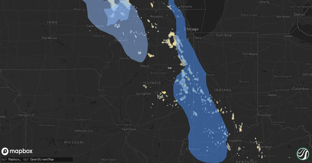
Hail Map in Illinois on June 30, 2019
Get this storm
June 30 map
$229
one time, instant access
Download today. No call, no setup
Keep the $229
Bought the map and want the full workflow? Apply the entire $229 to a subscription within 7 days. None of it is wasted.
Every map, not just this one
This buys you this map. Subscription and you get every map we run, in the markets you choose from a few cities to whole states to nationwide. Plus real-time alerts the moment a storm fires.
Contact data
Name, contact info, occupancy, even credit band for addresses in the footprint. You go from where it hit to who to call.
Become the source they trust
Unlimited branding weather history reports on demand. You already have the documented answer ready for the property owner, and you are the one who showed up with it.
Property data and RoofTrace estimates
Pull up any address you have got, its value and the exact code rules for that jurisdiction, straight from One Click Code. Then RoofTrace estimates the squares, pitch, and roof value, priced the way you price.
Storm reports in Illinois
Illinois
| Date | Description |
|---|---|
| 06/30/20196:57 PM CDT | 3 to 6 inch tree limbs down. |
| 06/30/20196:55 PM CDT | Delayed report via social media. Time estimated from radar. Three power poles snapped near the intersection of 2550 ave and highway 82. |
| 06/30/20196:52 PM CDT | Delayed report via social media. Time estimated from radar. Numerous trees down in the city. |
| 06/30/20196:50 PM CDT | Large 3 foot diameter tree snapped at base. Picture on social media. Time estimated based on radar. |
| 06/30/20196:50 PM CDT | 6 inch tree limb down... Report via twitter... Time estimated from radar. |
| 06/30/20196:49 PM CDT | Large branches down. Picture on social media. Time estimated based on radar. |
| 06/30/20196:45 PM CDT | Large tree branches down. |
| 06/30/20196:44 PM CDT | 2 to 3 inch tree limbs down and the power is out. Time estimated using radar. |
| 06/30/20196:44 PM CDT | Trees and power lines down. Delayed report. |
| 06/30/20196:32 PM CDT | Trees and power lines down. |
| 06/30/20196:32 PM CDT | Delayed report. |
| 06/30/20196:32 PM CDT | Trees and power lines down. |
| 06/30/20196:20 PM CDT | Delayed report from social media. Time estimated from radar. Shed flipped and destroyed on simmons street. |
| 06/30/20196:14 PM CDT | A local report indicates 63 MPH wind near 3 N STOCKTON |
| 06/30/20196:03 PM CDT | 8 inch diameter winds. |
| 06/30/20195:47 PM CDT | Large tree limb down... 9-12 inch in diameter. |
| 06/30/20195:45 PM CDT | Trees and power lines blown down over all of the northern one half of the county. Reported by the county sheriff at 619pm. |
| 06/30/20195:30 PM CDT | Delayed report. Large tree limbs down... Roof partially torn off metal shed. |
| 06/30/20195:29 PM CDT | Report from public relayed by broadcast media through social media. |
| 06/30/20195:24 PM CDT | Trees down and power lines down throughout the town. Reported by county emergency management and storm spotter. |
| 06/30/20195:24 PM CDT | Trees down and power lines down throughout the town. Reported by county emergency management and storm spotter. |
| 06/30/20195:20 PM CDT | Large tree uprooted along county road 1800e. Time estimated. |
| 06/30/20195:00 PM CDT | 12 power poles reported down on us 36 between shaw road and coffee pot circle. |
| 06/30/20195:00 PM CDT | Tree reported down on main street. Time estimated by radar. |
| 06/30/20194:58 PM CDT | A local report indicates 60 MPH wind near LONG CREEK |
| 06/30/20194:40 PM CDT | Large limbs and power lines reported down in town. |
| 06/30/20194:35 PM CDT | Tree down from outflow boundary |
| 06/30/20194:29 PM CDT | A local report indicates 67 MPH wind near WILLARD AIRPORT |
| 06/30/20194:25 PM CDT | Large tree branch down. |
| 06/30/20194:25 PM CDT | Tree reported down on university ave. Damaged a street light in process of falling. |
| 06/30/20194:20 PM CDT | Power outages across the area due to downed trees. |
| 06/30/20194:20 PM CDT | Numerous trees reported down throughout champaign/urbana. |
| 06/30/20194:18 PM CDT | A local report indicates 67 MPH wind near 2 SE URBANA |
| 06/30/20194:16 PM CDT | Large tree branch down. |
| 06/30/20194:16 PM CDT | Tree snapped at the base. |
| 06/30/20194:15 PM CDT | Traffic signal reported downed on prospect ave just north of i-74. |
| 06/30/20194:15 PM CDT | A local report indicates 63 MPH wind near WILLARD AIRPORT |
| 06/30/20194:00 PM CDT | Small plane flipped over at rantoul airport. |
| 06/30/20194:00 PM CDT | Several tree branches down. |
| 06/30/20193:55 PM CDT | Large limbs and power lines downed in 700 block of south street. |
| 06/30/20193:52 PM CDT | Iroquois county so reports powerlines down near church and bunker streets. |
| 06/30/20193:50 PM CDT | *** 1 fatal *** on north dayton ave in peoria... A 40 ft long 6 inch diameter tree branch snapped and hit a 39-yr old male knocking him unconscious. He later died at os |
| 06/30/20193:45 PM CDT | A local report indicates 1.75 inch wind near HENNING |
| 06/30/20193:45 PM CDT | Treehouse blown over |
| 06/30/20193:30 PM CDT | Powerlines down in fairbury. Relayed by livingston so. |
| 06/30/20193:22 PM CDT | Iroquois county so reports a brick wall collapsed and took down a powerline. |
| 06/30/20193:20 PM CDT | Livingston so reports numerous powerlines down throughout pontiac. Time estimated based on radar. |
| 06/30/20193:15 PM CDT | A local report indicates 1.00 inch wind near HOOPESTON |
| 06/30/20193:00 PM CDT | Power lines downed and shingles off roof north of grant park. Also 30 foot tree snapped. |
| 06/30/20193:00 PM CDT | Kankakee emergency management reports numerous trees down in the momence area including trees downed on to residences. Time estimated by radar. |
| 06/30/20193:00 PM CDT | Powerlines down in odell. |
| 06/30/20192:55 PM CDT | Multiple large branches downed in manteno. 6 to 12 inches diameter. |
| 06/30/20192:55 PM CDT | Tree reported down into pool. Estimated 50 mph winds. |
| 06/30/20192:53 PM CDT | A local report indicates 74 MPH wind near MANTENO |
| 06/30/20192:51 PM CDT | Weatherbug. |
| 06/30/20192:50 PM CDT | Semi rolled on i-57 near mile marker 322. |
| 06/30/20192:50 PM CDT | Report to social media of multiple large trees uprooted at kankakee sportsman club. Time estimated by radar. |
| 06/30/20192:45 PM CDT | 65 mph wind gust estimated. Small branches downed. |
| 06/30/20192:40 PM CDT | Relayed via the livingston county so: widespread tree damage in and around streator. Awnings and limbs on houses and cars throughout the area. Time estimated based on r |
| 06/30/20192:39 PM CDT | Several photos showing a landspout tornado immediately ese of gilman. Time matched based on radar and time stamps on social media images. |
| 06/30/20192:35 PM CDT | Delayed report of many 4-inch tree limbs down throughout the town... With a few limbs larger than 8 inches down as well. A couple 6-inch trees uprooted and a 2 ft. Diam |
| 06/30/20192:30 PM CDT | Winds estimated greater than 60 mph near us-52 in manhattan. |
| 06/30/20192:27 PM CDT | Wilmington so reports widespread tree damage across the town of wilmington. Route 102 is blocked by large trees across the roadway. |
| 06/30/20192:25 PM CDT | Report of numerous trees down in morris relayed by grundy county so. Time estimated based on radar. |
| 06/30/20192:20 PM CDT | Top of large tree blown off. |
| 06/30/20192:13 PM CDT | Large portion of tree downed on electrical wires... Snapping top portion of adjacent pole. Time estimated on radar. |
| 06/30/20192:12 PM CDT | Three large tree limbs down. Limb diameters range from 6 inches to one foot. Time estimated based on radar. |
| 06/30/20192:12 PM CDT | Photos of several large |
| 06/30/20192:00 PM CDT | Time estimated by radar. |
| 06/30/20192:00 PM CDT | Report to social media of a tree uprooted near eola road in aurora. Time estimated by radar. |
| 06/30/20191:50 PM CDT | Glen ellyn pd reports via social media power lines and trees downed near st charles and crescent. Time estimated by radar. |
| 06/30/20191:50 PM CDT | Multiple 4 in diameter branches downed. Relayed via spotter network. Time estimated by radar. |
| 06/30/20191:45 PM CDT | Deerpath road in north aurora blocked by large downed tree. Time estimated by radar. |
| 06/30/20191:40 PM CDT | Multiple large branches downed. |
| 06/30/20191:35 PM CDT | Picture shared via social media of large commercial sign blown down on to a car. |
| 06/30/20191:35 PM CDT | Numerous tree branches downed in vicinity of palatine road and il-53. Max diameter at least 6-in. Relayed via social media. Time estimated by radar. |
| 06/30/20191:34 PM CDT | Video and detailed description showing two well-defined gustnados at the corner of scott and dauberman roads. Debris was blown over 3/4 of a mile to the south. |
| 06/30/20191:30 PM CDT | Delayed report... Received via social media... Of multiple large tree limbs down. Time estimated via radar. |
| 06/30/20191:25 PM CDT | Tree down on main street and dundee. Time estimated by radar. |
| 06/30/20191:20 PM CDT | Photo shared via social media of large tree branch downed on to power lines. Time estimated via radar. |
| 06/30/20191:20 PM CDT | Numerous large branches downed near us-12 and lakeshore drive in wauconda. One branch about 8-in diameter. Time estimated by radar. |
| 06/30/20191:20 PM CDT | Powerlines and trees downed blocking roads in north barrington and wauconda areas. |
| 06/30/20191:15 PM CDT | Minor damage to trees in oregon. |
| 06/30/20191:15 PM CDT | Numerous tree branches downed... Some about 4 inch in diameter. Time estimated by radar. |
| 06/30/20191:15 PM CDT | Numerous tree branches downed in antioch. Time estimated by radar. |
| 06/30/20191:10 PM CDT | Tree branch downed on to road in island lake area. |
| 06/30/20191:00 PM CDT | Numerous large branches downed. Damage to siding. Time estimated by radar. |
| 06/30/20191:00 PM CDT | Asos rfd. |
| 06/30/201912:50 PM CDT | Public reports several trees downed along il-2 between kennedy hill road and prairie road between byron and rockford. Relayed via media. Time estimated by radar. |
| 06/30/201912:50 PM CDT | Public reports tree downed near baxter road and il-251. Relayed via broadcast media. |
| 06/30/201912:40 PM CDT | Public reports multiple trees downed in vicinity of meridian road and west state. Relayed via broadcast media. Time estimated by radar. |
| 06/30/20196:59 AM CDT | At 1157 AM CDT, severe thunderstorms were located along a line extending from near Wales to Milton, moving southeast at 35 mph. HAZARD...60 mph wind gusts. SOURCE...Law enforcement. There have been numerous reports of tree damage and power outages. IMPACT...Expect damage to roofs, siding, and trees. Locations impacted include... Kenosha, Waukesha, Janesville, New Berlin, Brookfield, Muskego, Pleasant Prairie, Whitewater, Pewaukee, Fort Atkinson, Sussex, Elkhorn, Hartland, Delavan, Lake Geneva, Mukwonago, Delafield, Twin Lakes, Milton and Union Grove. |
| 06/30/20193:32 AM CDT | At 831 PM CDT, a severe thunderstorm was located near Goodfield, or 8 miles southeast of Eureka, moving southeast at 45 mph. HAZARD...60 mph wind gusts. SOURCE...Radar indicated. IMPACT...Expect damage to roofs, siding, and trees. Locations impacted include... Bloomington, Lincoln, Eureka, Normal, Morton, Le Roy, Heyworth, El Paso, Tremont, Lexington, Mackinaw, Hudson, Atlanta, Delavan, Gridley, Minier, Danvers, South Pekin, Colfax and Downs.This includes the following highways... Interstate 155 between mile markers 9 and 30. Interstate 39 between mile markers 0 and 21. Interstate 55 between mile markers 131 and 181. Interstate 74 between mile markers 104 and 150. |
| 06/30/20193:01 AM CDT | At 800 PM CDT, severe thunderstorms were located along a line extending from near Varna to near Brimfield, moving southeast at 35 mph. HAZARD...60 mph wind gusts. SOURCE...Radar indicated. IMPACT...Expect damage to roofs, siding, and trees. Locations impacted include... Peoria, Pekin, Eureka, Lacon, East Peoria, Morton, Washington, Bartonville, Chillicothe, Creve Coeur, West Peoria, Metamora, Germantown Hills, Marquette Heights, El Paso, Henry, Tremont, Elmwood, Minonk and Roanoke.This includes the following highways... Interstate 155 between mile markers 21 and 31. Interstate 39 between mile markers 12 and 40. Interstate 474 between mile markers 0 and 14. Interstate 74 between mile markers 68 and 118. |
| 06/30/20192:59 AM CDT | At 757 PM CDT, severe winds out ahead of approaching thunderstorms were located along a line extending from near Norris City to near Corydon, moving south at 40 mph. There are reports of trees down along this line of winds. HAZARD...60 mph wind gusts. SOURCE...Radar indicated. IMPACT...Expect damage to roofs, siding, and trees. Locations impacted include... Morganfield, Shawneetown, Breckinridge Center, Uniontown, Ridgway, Equality, New Haven, Waverly, Omaha, Old Shawneetown and Junction. |
| 06/30/20192:45 AM CDT | At 743 PM EDT, a severe thunderstorm was located near Vincennes, moving south at 30 mph. HAZARD...70 mph wind gusts. SOURCE...Radar indicated. IMPACT...Expect considerable tree damage. Damage is likely to mobile homes, roofs, and outbuildings. Locations impacted include... Vincennes, Washington, Bicknell, Loogootee, Odon, Elnora, Oaktown, Monroe City, Wheatland, Bruceville, Plainville, Sandborn, Montgomery, Edwardsport, Decker, Cannelburg, Alfordsville, West Boggs Lake, Freelandville and Vincennes University. |
| 06/30/20192:35 AM CDT | At 735 PM CDT, severe thunderstorms were located along a line extending from near Buda to 7 miles south of North Henderson, moving southeast at 55 mph. HAZARD...60 mph wind gusts. SOURCE...Radar indicated. IMPACT...Expect damage to roofs, siding, and trees. Locations impacted include... Peoria, Galesburg, Canton, Lacon, Chillicothe, Abingdon, Knoxville, Henry, Farmington, Elmwood, Princeville, Rome, Wyoming, Dunlap, Cuba, Toulon, Trivoli, Osceola, Brimfield and Wataga.This includes Interstate 74 between mile markers 35 and 83. |
| 06/30/20192:26 AM CDT | At 726 PM CDT, severe thunderstorms were located along a line extending from near Amboy to near Princeton to Kewanee, moving southeast at 45 mph. HAZARD...60 mph wind gusts. SOURCE...Radar indicated. IMPACT...Expect damage to roofs, siding, and trees. Locations impacted include... Hennepin, Spring Valley, Henry, DePue, Granville, Ladd, Tiskilwa, Dalzell, Bureau Junction, McNabb, Putnam, Mark, Cherry, Neponset, Seatonville, Magnolia, Standard, Milo, Spring Valley Airport and Providence.This includes the following highways... Interstate 80 in Illinois between mile markers 68 and 72. Interstate 180 between mile markers 1 and 5. |
| 06/30/20192:14 AM CDT | At 711 PM CDT, strong winds ahead a line of thunderstorms were located along a line extending from near Albion to 7 miles northwest of Poseyville to near Lynnville, moving south at 40 mph. These winds have knocked down some trees in Mount Carmel Illinois. HAZARD...60 mph wind gusts. SOURCE...Trained weather spotters. IMPACT...Expect damage to roofs, siding, and trees. Locations impacted include... Evansville, Mount Vernon, Carmi, Newburgh, Fort Branch, Melody Hill, Grayville, Haubstadt, Darmstadt, Owensville, Poseyville, New Harmony, Crossville, Cynthiana, Blairsville, Kasson, Elberfeld, Keensburg, Griffin and Maunie. |
| 06/30/20192:09 AM CDT | At 708 PM CDT, severe thunderstorms were located along a line extending from near Dixon to Walnut to near Hooppole, moving southeast at 45 mph. HAZARD...60 mph wind gusts. SOURCE...Radar indicated. IMPACT...Expect damage to roofs, siding, and trees. Locations impacted include... Sterling, Rock Falls, Princeton, DePue, Walnut, Wyanet, Sheffield, Tiskilwa, Tampico, La Moille, Buda, Bureau Junction, Deer Grove, Ohio, Cherry, Neponset, Yorktown, Malden, Manlius and Seatonville.This includes the following highways... Interstate 80 in Illinois between mile markers 36 and 68. Interstate 88 between mile markers 36 and 44. Interstate 180 between mile markers 2 and 13. |
| 06/30/20191:56 AM CDT | At 654 PM CDT, severe thunderstorms were located along a line extending from near Erie to near Eliza to 6 miles southwest of Tiffin, moving south at 45 mph. HAZARD...60 mph wind gusts. SOURCE...Radar indicated. IMPACT...Expect damage to roofs, siding, and trees. Locations impacted include... Davenport, Iowa City, Moline, Rock Island, Bettendorf, Muscatine, East Moline, Kewanee, Washington, Aledo, Cambridge, Wapello, Columbus Junction, Silvis, Geneseo, Milan, Colona, Le Claire, Coal Valley and West Liberty.If you are at Henry County Fairgrounds in Cambridge you should seeksafe shelter immediately!This includes the following highways... Interstate 74 in Iowa between mile markers 1 and 5. Interstate 80 in Iowa between mile markers 295 and 306. Interstate 80 in Illinois between mile markers 1 and 35. Interstate 74 in Illinois between mile markers 1 and 33. Interstate 88 between mile markers 1 and 15. Interstate 280 between mile markers 2 and 18. |
| 06/30/20191:56 AM CDT | At 656 PM EDT, a severe thunderstorm was located 10 miles north of Shoals, or 15 miles west of Bedford, moving south at 10 mph. HAZARD...60 mph wind gusts. SOURCE...Radar indicated. IMPACT...Expect damage to roofs, siding, and trees. Locations impacted include... Vincennes, Bedford, Washington, Sullivan, Shoals, Mitchell, Bicknell, Loogootee, Odon, Shelburn, Oolitic, Dugger, Hymera, Carlisle, Elnora, Oaktown, Monroe City, Wheatland, Bruceville and Plainville. |
| 06/30/20191:22 AM CDT | At 622 PM CDT, severe thunderstorms were located along a line extending from near Charlotte to near Rochester to Amana, moving south at 45 mph. HAZARD...70 mph wind gusts. SOURCE...Trained weather spotters. IMPACT...Expect considerable tree damage. Damage is likely to mobile homes, roofs, and outbuildings. Locations impacted include... Davenport, Iowa City, Moline, Rock Island, Bettendorf, Muscatine, East Moline, Sterling, Kewanee, Rock Falls, Washington, Morrison, Aledo, Cambridge, Wapello, Columbus Junction, Durant, Silvis, Geneseo and Eldridge.If you are at Henry County Fairgrounds in Cambridge, or DavenportAirport you should seek safe shelter immediately!This includes the following highways... Interstate 74 in Iowa between mile markers 1 and 5. Interstate 80 in Iowa between mile markers 276 and 306. Interstate 80 in Illinois between mile markers 1 and 45. Interstate 74 in Illinois between mile markers 1 and 33. Interstate 88 between mile markers 1 and 43. Interstate 280 between mile markers 1 and 18. |
| 06/30/20191:16 AM CDT | At 615 PM CDT, severe thunderstorms were located along a line extending from near Stockton to Preston, moving southeast at 50 mph. HAZARD...70 mph wind gusts. SOURCE...Trained weather spotters. These storms have a history of producing wind damage. IMPACT...Expect considerable tree damage. Damage is likely to mobile homes, roofs, and outbuildings. Locations impacted include... Clinton, Sterling, Rock Falls, Morrison, Mount Carroll, Fulton, Savanna, Lanark, Garden Plain, Milledgeville, Fairhaven, Albany, Shannon, Sabula, Chadwick, Coleta, East Clinton, Emerson, Argo Fay and Union Grove.This includes Interstate 88 between mile markers 33 and 36, and nearmile marker 44. |
| 06/30/20191:00 AM CDT | At 559 PM CDT, severe thunderstorms were located along a line extending from near Bellevue to near Stanwood to near Newhall, moving south at 45 mph. HAZARD...70 mph wind gusts and quarter size hail. SOURCE...Trained weather spotters. IMPACT...Hail damage to vehicles is expected. Expect considerable tree damage. Wind damage is also likely to mobile homes, roofs, and outbuildings. Locations impacted include... Cedar Rapids, Iowa City, Clinton, Maquoketa, Tipton, West Branch, Mechanicsville, Stanwood, Marion, Coralville, North Liberty, Hiawatha, DeWitt, Mount Vernon, Camanche, Bellevue, Lisbon, Fairfax, Solon and Tiffin.This includes the following highways... Interstate 80 in Iowa between mile markers 230 and 279. Interstate 380 between mile markers 1 and 25. |
| 06/30/201912:16 AM CDT | At 516 PM CDT, a severe thunderstorm was located near Charleston, moving south at 15 mph. HAZARD...60 mph wind gusts and quarter size hail. SOURCE...Radar indicated. IMPACT...Hail damage to vehicles is expected. Expect wind damage to roofs, siding, and trees. Locations impacted include... Charleston, Mattoon, Oakland, Ashmore, Humboldt, Lerna, Cooks Mill, Rardin, Janesville, Coles, Paradise, Hutton, Etna, Fairgrange, Fox Ridge State Park, Bushton, Coles County Airport and Trilla.This includes Interstate 57 between mile markers 180 and 200. |
| 06/29/201911:49 PM CDT | At 447 PM EDT, severe thunderstorms were located along a line extending from near Brook to near Milford, moving southeast at 35 mph. HAZARD...60 mph wind gusts. SOURCE...Trained spotters indicated. Widespread wind damage has been reported in Manteno and Momence Illinois. IMPACT...Expect damage to roofs, siding, and trees. Locations impacted include... Fowler, Otterbein, Dunnington, Atkinson, Wadena, Talbot, Lochiel, Templeton, Barce, Raub, Freeland Park, Foresman, Oxford, Boswell, Earl Park and Ambia. |
| 06/29/201911:49 PM CDT | At 449 PM CDT, a severe thunderstorm was located near Cerro Gordo, or 11 miles east of Decatur, moving southeast at 10 mph. HAZARD...60 mph wind gusts and quarter size hail. SOURCE...Radar indicated. IMPACT...Hail damage to vehicles is expected. Expect wind damage to roofs, siding, and trees. Locations impacted include... Mount Zion, Cerro Gordo, Long Creek, Lovington, Dalton City, Hammond, La Place and Lake City. |
| 06/29/201911:46 PM CDT | At 446 PM CDT, a severe thunderstorm was located over Marshall, moving southwest at 10 mph. HAZARD...60 mph wind gusts and quarter size hail. SOURCE...Radar indicated. IMPACT...Hail damage to vehicles is expected. Expect wind damage to roofs, siding, and trees. Locations impacted include... Marshall, Martinsville, West Union, Oliver, Dennison, York, Darwin and Lincoln Trail State Park.This includes Interstate 70 between mile markers 138 and 154. |
| 06/29/201911:08 PM CDT | At 408 PM CDT, a severe thunderstorm was located over Fairmount, or 14 miles southwest of Danville, moving southeast at 10 mph. HAZARD...60 mph wind gusts and quarter size hail. SOURCE...Radar indicated. IMPACT...Hail damage to vehicles is expected. Expect wind damage to roofs, siding, and trees. Locations impacted include... Georgetown, Catlin, Oakwood, Homer, Ridge Farm, Fairmount, Sidell, Fithian, Muncie, Indianola, Jamaica and Palermo.This includes Interstate 74 between mile markers 200 and 206. |
| 06/29/201911:06 PM CDT | At 406 PM CDT, a severe thunderstorm was located over Thomasboro, or near Rantoul, moving southeast at 10 mph. HAZARD...60 mph wind gusts and quarter size hail. SOURCE...Radar indicated. IMPACT...Hail damage to vehicles is expected. Expect wind damage to roofs, siding, and trees. Locations impacted include... Champaign, Rantoul, Urbana, Savoy, St. Joseph, Philo, Sidney, Thomasboro, Ogden and Flatville.This includes the following highways... Interstate 57 between mile markers 236 and 252. Interstate 74 between mile markers 176 and 197. |
| 06/29/201910:43 PM CDT | At 342 PM CDT, severe thunderstorms were located along a line extending from 7 miles west of Morocco to near Watseka, moving southeast at 20 mph. This is in an area previously warned where storms are remaining very strong. HAZARD...60 mph wind gusts. SOURCE...Radar indicated. IMPACT...Expect damage to roofs, siding, and trees. Locations impacted include... Watseka, Martinton, Beaverville, Donovan, Papineau and Iroquois. |
| 06/29/201910:27 PM CDT | At 327 PM CDT, a severe thunderstorm was located near Sidell, or 16 miles north of Paris, moving south at 10 mph. HAZARD...60 mph wind gusts and quarter size hail. SOURCE...Radar indicated. IMPACT...Hail damage to vehicles is expected. Expect wind damage to roofs, siding, and trees. Locations impacted include... Chrisman, Sidell, Hume, Brocton, Edgar, Isabel, Metcalf, Palermo, Edgar County Airport and Borton. |
| 06/29/201910:21 PM CDT | At 320 PM CDT, severe thunderstorms were located along a line extending from near Morocco to near Onarga to 7 miles north of Gibson, moving southeast at 45 mph. HAZARD...70 mph wind gusts. SOURCE...Radar indicated. IMPACT...Expect considerable tree damage. Damage is likely to mobile homes, roofs, and outbuildings. Locations impacted include... Watseka, Paxton, Gibson City, Stockland, Claytonville, Milford, Sheldon, Cissna Park, Buckley, Gibson, Melvin, Loda, Roberts, Woodland, Elliott, Sibley, Wellington and Iroquois.Including the following interstate... I-57 between mile markers 258 and 275. |
| 06/29/201910:16 PM CDT | At 316 PM CDT, a severe thunderstorm was located over Hoopeston, or 9 miles west of Talbot, moving southeast at 10 mph. HAZARD...60 mph wind gusts and quarter size hail. SOURCE...Radar indicated. IMPACT...Hail damage to vehicles is expected. Expect wind damage to roofs, siding, and trees. Locations impacted include... Hoopeston, Rossville, Bismarck, Henning and Alvin. |
| 06/29/201910:06 PM CDT | At 306 PM CDT, severe thunderstorms were located along a line extending from near Osceola to near Varna to Wenona, moving south at 15 mph. HAZARD...60 mph wind gusts and quarter size hail. SOURCE...Radar indicated. IMPACT...Hail damage to vehicles is expected. Expect wind damage to roofs, siding, and trees. Locations impacted include... Lacon, Wyoming, Toluca, Toulon, Wenona, Osceola, Bradford, Sparland, Varna, Elmira, Castleton, Camp Grove, Hopewell, Duncan, La Rose, Pattonsburg and Marshall County Airport.This includes Interstate 39 between mile markers 29 and 40. |
| 06/29/201910:04 PM CDT | At 303 PM CDT, severe thunderstorms were located along a line extending from near Beecher to near Grant Park to near Hopkins Park to Clifton, moving southeast at 40 mph. These are very dangerous storms. HAZARD...80 mph wind gusts. SOURCE...Trained weather spotters. Winds to 75 mph were reported in Manteno Illinois with these storms. IMPACT...Flying debris will be dangerous to those caught without shelter. Mobile homes will be heavily damaged. Expect considerable damage to roofs, windows, and vehicles. Extensive tree damage and power outages are likely. Locations impacted include... Lowell, Rensselaer, De Motte, Kentland, Morocco, Hanging Grove, Percy Junction, Thayer, Roselawn, Gifford, Enos, Pembroke, Fair Oaks, Pleasant Ridge, Conrad, Perkins, Sumava Resorts, McCoysburg, Beaver City and Moody.Including the following interstate... Indiana I-65 between mile markers 200 and 239. This includes... US 41 Dragway. |
| 06/29/201910:01 PM CDT | At 300 PM CDT, severe thunderstorms were located along a line extending from Momence to St. Anne to near Clifton to 7 miles west of Ashkum, moving southeast at 40 mph. These are very dangerous storms. HAZARD...80 mph wind gusts. SOURCE...Radar indicated. IMPACT...Flying debris will be dangerous to those caught without shelter. Mobile homes will be heavily damaged. Expect considerable damage to roofs, windows, and vehicles. Extensive tree damage and power outages are likely. Locations impacted include... Kankakee, Watseka, Gilman, Clifton, Onarga, St. Anne, Chebanse, Ashkum, Aroma Park, Hopkins Park, Crescent City, Danforth, Martinton, Beaverville, Donovan, Thawville, Papineau, Iroquois and Irwin.Including the following interstate... I-57 between mile markers 275 and 309. This includes... Kankakee County Fairgrounds and Speedway. |
| 06/29/20199:59 PM CDT | At 258 PM CDT, a severe thunderstorm was located near Rankin, or 11 miles east of Paxton, moving south at 15 mph. HAZARD...60 mph wind gusts and quarter size hail. SOURCE...Radar indicated. IMPACT...Hail damage to vehicles is expected. Expect wind damage to roofs, siding, and trees. Locations impacted include... Danville, Ogden, Potomac, Rankin, Royal, Henning, Middle Fork Wildlife Area, Armstrong, Collison and Penfield.This includes Interstate 74 between mile markers 197 and 200. |
| 06/29/20199:43 PM CDT | At 243 PM CDT, severe thunderstorms were located along a line extending from near Flanagan to near Chebanse, moving south at 50 mph. HAZARD...60 mph wind gusts. SOURCE...Radar indicated. IMPACT...Expect damage to roofs, siding, and trees. Locations impacted include... Pontiac, Fairbury, Piper City, Gridley, Forrest, Chatsworth, Flanagan, Cullom, Saunemin, Roberts, Cabery, Kempton, Emington and Strawn.Including the following interstate... I-55 between mile markers 188 and 206. |
| 06/29/20199:28 PM CDT | At 228 PM CDT, severe thunderstorms were located along a line extending from near Granville to near Streator to 6 miles west of Herscher, moving south at 45 mph. HAZARD...60 mph wind gusts. SOURCE...Radar indicated. IMPACT...Expect damage to roofs, siding, and trees. Locations impacted include... Ottawa, Streator, Morris, Channahon, Minooka, Peru, Marseilles, Dwight, Oglesby, Seneca, La Salle, Coal City, Diamond, Utica, Gardner, North Utica, Wenona, Odell, Mazon and Braceville.Including the following interstates... I-39 between mile markers 41 and 59. I-55 between mile markers 206 and 232. I-80 between mile markers 75 and 76, and between mile markers 78 and118.This includes... Buffalo Rock State Park, Gebhard Woods State Park,Grundy County Speedway and Fairgrounds, Illini State Park, IllinoisValley Community College, Matthiessen State Park, Starved Rock StatePark, and William G Stratton State Park. |
| 06/29/20199:15 PM CDT | Large tree downed on power lines. |
| 06/29/20199:02 PM CDT | At 201 PM CDT, severe thunderstorms were located along a line extending from near Plainfield to 7 miles northeast of Walnut, moving southeast at 25 mph. HAZARD...60 mph wind gusts. SOURCE...Radar indicated. IMPACT...Expect damage to roofs, siding, and trees. Locations impacted include... Aurora, Joliet, Plainfield, St. Charles, Oswego, Batavia, Geneva, Ottawa, Yorkville, Streator, Little Rock, Channahon, Minooka, Plano, Peru, Sandwich, Mendota, Marseilles, Oglesby and Seneca.Including the following interstates... I-39 between mile markers 41 and 92. I-55 between mile markers 248 and 253. I-80 between mile markers 73 and 103, and between mile markers 119and 128. I-88 between mile markers 98 and 117.This includes... Sandwich Fairgrounds, Aurora University, BuffaloRock State Park, IL Math and Science Academy, Illini State Park,Illinois Valley Community College, Joliet Junior College, Lee CountyFairgrounds, Matthiessen State Park, Starved Rock State Park,Tri-County Fairgrounds, and Waubonsee Community College. |
| 06/29/20198:46 PM CDT | At 145 PM CDT, a severe thunderstorm was located near Coal City, or near Morris, moving east at 20 mph. HAZARD...60 mph wind gusts and quarter size hail. SOURCE...Radar indicated. IMPACT...Hail damage to vehicles is expected. Expect wind damage to roofs, siding, and trees. Locations impacted include... Morris, Channahon, Minooka, Dwight, Seneca, Wilmington, Braidwood, Coal City, Diamond, Gardner, Mazon, Braceville, Lakewood Shores, Essex, South Wilmington, Godley, Carbon Hill, Verona, East Brooklyn and Kinsman.Including the following interstates... I-55 between mile markers 219 and 248. I-80 between mile markers 104 and 119.This includes... Channahon State Park, Gebhard Woods State Park,Grundy County Speedway and Fairgrounds, and William G Stratton StatePark. |
| 06/29/20198:30 PM CDT | A local report indicates 60 MPH wind near MORTON |
| 06/29/20198:30 PM CDT | Small 2-3inch diameter branches reported down... With estimated 50-55mph winds. |
| 06/29/20198:25 PM CDT | Power line reported down. Power is out in area. Time estimated by radar. |
| 06/29/20198:20 PM CDT | House damaged by pergola around high/8th street. |
| 06/29/20198:20 PM CDT | Tree down on hwy 13 blocking one lane of the road. |
| 06/29/20198:20 PM CDT | Report of multiple trees down in harrisburg. |
| 06/29/20198:15 PM CDT | Power line snapped in town. 24 inch diameter tree reported on niles/partridge streets. Power pole down 1200n prairie/dee mac roads. |
| 06/29/20198:13 PM CDT | At 112 PM CDT, severe thunderstorms were located along a line extending from near Hampshire to near Byron, moving south at 45 mph. A gust front out ahead of the line of storms may produce damagaing wind gusts ahead of the complex of storms. HAZARD...60 mph wind gusts. SOURCE...Radar indicated. IMPACT...Expect damage to roofs, siding, and trees. Locations impacted include... Aurora, Rockford, St. Charles, Oswego, Batavia, Belvidere, Sycamore, Yorkville, Dixon, Little Rock, Rochelle, Genoa, Oregon, Mount Morris, Shabbona, Rockford Airport, DeKalb, Montgomery, North Aurora and Sugar Grove.Including the following interstates... I-39 between mile markers 84 and 123. I-88 between mile markers 45 and 118. I-90 between mile markers 41 and 63.This includes... Northern Illinois University, Aurora University,Boone County Fairgrounds, Castle Rock State Park, IL Math and ScienceAcademy, Lee County Fairgrounds, Lowden State Park, Ogle CountyFairgrounds, Sauk Valley College, Waubonsee Community College, andWhite Pines State Park. |
| 06/29/20198:09 PM CDT | Delayed report via social media. Time estimated from radar and location approximated. Pine tree snapped about 6 feet above ground from thunderstorm gust front on n 1550 |
| 06/29/20198:09 PM CDT | Corrects previous tstm wnd dmg report from 2 ene bardolph. Delayed report via social media. Time estimated from radar and location approximated. Pine tree snapped about |
| 06/29/20198:05 PM CDT | Report of 60 mph winds along outflow boundary as it moved through town. |
| 06/29/20197:54 PM CDT | Power lines down in the la harpe area. Time estimated by radar. Report via wgem. |
| 06/29/20197:50 PM CDT | Tree limbs blown down. Estimated 60+ mph. From spotter. |
| 06/29/20197:48 PM CDT | Time of the event was estimated using radar. Power line down in granville and tree down across the road on highway 26 near hennepin. |
| 06/29/20197:44 PM CDT | Several 3 inch diameter tree limbs downed from outflow ahead of main storms. |
| 06/29/20197:42 PM CDT | Tree snapped off at the base and power lines down near this location. |
| 06/29/20197:40 PM CDT | Small shed overturned. |
| 06/29/20197:29 PM CDT | Several branches down on highway 34. Size unknown. Time estimated from radar. |
| 06/29/20197:26 PM CDT | Corrects previous tstm wnd dmg report from 1 ssw galva. Tree snapped off at the base and power lines down near this location. |
| 06/29/20197:26 PM CDT | Several small tree branches approx 3 inch diameter down. Power lines down. |
| 06/29/20197:24 PM CDT | Large tree uprooted. Photo via twitter. |
| 06/29/20197:22 PM CDT | Handheld anemometer. |
| 06/29/20197:05 PM CDT | Trees blown down... Including one on a house. |
| 06/29/20197:00 PM CDT | Tree blown onto a house. |
All States Impacted by Hail Map on June 30, 2019
Cities Impacted by Hail Map on June 30, 2019
- Shakopee, MN
- Jordan, MN
- Stockton, IL
- Hill City, SD
- Walnut Grove, MN
- Midkiff, TX
- Newark, IL
- Minooka, IL
- Channahon, IL
- Shorewood, IL
- Morris, IL
- Miller, SD
- Adams, MN
- Nashville, IN
- McCamey, TX
- Crane, TX
- Sebring, FL
- Argenta, IL
- Cerro Gordo, IL
- Bremen, ME
- Bristol, ME
- Cranston, RI
- West Warwick, RI
- Hope, RI
- Warwick, RI
- Johnston, RI
- East Greenwich, RI
- Kyle, SD
- Elkton, SD
- Ottertail, MN
- Richville, MN
- Gaylord, MN
- Cologne, MN
- Hamburg, MN
- Norwood Young America, MN
- Henderson, MN
- Glencoe, MN
- Green Isle, MN
- Plato, MN
- Arlington, MN
- Young America, MN
- Spencer, SD
- Middleboro, MA
- Kendall, WI
- Saint Joseph, IL
- New Richland, MN
- Waseca, MN
- Kansas, IL
- Gregory, SD
- Dallas, SD
- Burke, SD
- Winner, SD
- Hamill, SD
- Bloomington, IN
- Ellettsville, IN
- Lodi, WI
- Dane, WI
- Prairie Du Sac, WI
- Madison, WI
- Waunakee, WI
- Sauk City, WI
- Mount Horeb, WI
- Mazomanie, WI
- Verona, WI
- Middleton, WI
- Cross Plains, WI
- Hume, IL
- Metcalf, IL
- Lee, IL
- Aurora, IL
- Montgomery, IL
- Yorkville, IL
- Oswego, IL
- Sugar Grove, IL
- Plano, IL
- Big Rock, IL
- Bristol, IL
- Fairbanks, IN
- Shelburn, IN
- Wellington, IL
- Hoopeston, IL
- Lodge Grass, MT
- Cheyenne, WY
- Jasper, IN
- Walworth, WI
- Williams Bay, WI
- Fontana, WI
- Lake Geneva, WI
- Delavan, WI
- Otter, MT
- Orfordville, WI
- Imperial, TX
- Ashkum, IL
- Mattoon, IL
- Lance Creek, WY
- Big Timber, MT
- Scales Mound, IL
- Rewey, WI
- Bloomington, WI
- Mineral Point, WI
- Platteville, WI
- Benton, WI
- Shullsburg, WI
- Highland, WI
- Belmont, WI
- Livingston, WI
- Linden, WI
- Dodgeville, WI
- Fennimore, WI
- Mount Hope, WI
- Lancaster, WI
- Cuba City, WI
- Potosi, WI
- Darlington, WI
- Marengo, IL
- Lewellen, NE
- Arthur, NE
- Salem, IN
- Campbellsburg, IN
- West Point, KY
- Muldraugh, KY
- Lewisport, KY
- Wisconsin Rapids, WI
- Oakland, IL
- Garrison, MN
- Wahkon, MN
- Onamia, MN
- Red Wing, MN
- Sidney, NE
- Macon, IL
- Boody, IL
- Moweaqua, IL
- Brazil, IN
- Pekin, IN
- Borden, IN
- Campton, KY
- Russell, MN
- Tyler, MN
- Rossville, IL
- Williamsport, IN
- Hendricks, MN
- Evansville, WI
- Beloit, WI
- Brodhead, WI
- Cornell, WI
- Holcombe, WI
- Peetz, CO
- Mooresville, IN
- Montgomery, IN
- Fredericksburg, IN
- Verndale, MN
- Black River Falls, WI
- Platte, SD
- Seneca, IL
- Parmelee, SD
- Saint Francis, SD
- Sheridan, WY
- Camden, AR
- Lime Springs, IA
- Chester, IA
- Le Roy, MN
- Sparland, IL
- Henry, IL
- Varna, IL
- Lacon, IL
- Toluca, IL
- Weldona, CO
- Merrillan, WI
- Mason City, IA
- Manly, IA
- Pierz, MN
- Hillman, MN
- Onida, SD
- Fairfax, MN
- Franklin, MN
- Frankfort, KY
- Spearsville, LA
- Lamberton, MN
- Norwalk, WI
- Sparta, WI
- Tomah, WI
- Wilton, WI
- Rochdale, MA
- North Oxford, MA
- Auburn, MA
- Freedom, IN
- Coal City, IN
- White, SD
- Cannon Falls, MN
- Grover, CO
- Farmingville, NY
- Holtsville, NY
- Penfield, IL
- Loda, IL
- Ludlow, IL
- Cissna Park, IL
- Rankin, IL
- Potomac, IL
- Buckley, IL
- Paxton, IL
- Hardinsburg, IN
- Rice, MN
- Sauk Rapids, MN
- Springfield, KY
- Saint Catharine, KY
- Fort Morgan, CO
- Keenesburg, CO
- Roggen, CO
- Watertown, WI
- Jay Em, WY
- Fort Laramie, WY
- Bonfield, IL
- Kankakee, IL
- East Islip, NY
- Oakdale, NY
- Great River, NY
- Oregon, IL
- Chana, IL
- Ashton, IL
- Palm Bay, FL
- Melville, MT
- Newcastle, WY
- Seymour, IN
- Elizabethtown, IN
- Columbus, IN
- Seaforth, MN
- Vesta, MN
- Sacred Heart, MN
- Danube, MN
- Hanley Falls, MN
- Cottonwood, MN
- Olivia, MN
- Belview, MN
- Echo, MN
- Morton, MN
- Redwood Falls, MN
- Renville, MN
- Wood Lake, MN
- Wabasso, MN
- Salem, SD
- Winfred, SD
- Montrose, SD
- Marion, LA
- Lebanon, SD
- Mora, MN
- Ogilvie, MN
- Hanover, IN
- Nabb, IN
- Lexington, IN
- Hager City, WI
- Lead, SD
- Dubuque, IA
- Durango, IA
- Cassville, WI
- Holy Cross, IA
- Glen Haven, WI
- North Buena Vista, IA
- Wanblee, SD
- Interior, SD
- Kadoka, SD
- Wood Lake, NE
- Granite Falls, MN
- Gays Mills, WI
- Amana, IA
- Carbon, IN
- Rosedale, IN
- Reelsville, IN
- Bedford, IN
- Custer, SD
- Greencastle, IN
- Ideal, SD
- La Motte, IA
- Bellevue, IA
- Ruthton, MN
- Keystone, SD
- Siren, WI
- Charleston, IL
- Sterling City, TX
- Eagle Bend, MN
- Kimball, SD
- New York Mills, MN
- Sutton, MA
- Oxford, MA
- Belfry, KY
- Sidney, KY
- Austin, MN
- Kersey, CO
- Homer, IL
- Fairmount, IL
- Fithian, IL
- Big Lake, TX
- Brandt, SD
- Hinckley, MN
- Grantsburg, WI
- Pine City, MN
- Camp Douglas, WI
- Rockville, IN
- Cody, NE
- Nenzel, NE
- Kilgore, NE
- New Prague, MN
- Chrisman, IL
- Franktown, CO
- Castle Rock, CO
- Thorp, WI
- Greenwood, WI
- Clear Lake, SD
- Crow Agency, MT
- Vesper, WI
- Conrath, WI
- Madison, MN
- Toronto, SD
- Arco, MN
- Brookings, SD
- Minneota, MN
- Ivanhoe, MN
- Bruce, SD
- Ellsworth, NE
- Bingham, NE
- Elsie, NE
- Attica, IN
- Covington, IN
- West Lebanon, IN
- Realitos, TX
- Upton, WY
- Oxford, WI
- Endeavor, WI
- Orlando, FL
- Moore Haven, FL
- Clewiston, FL
- Athol, MA
- Petersham, MA
- Osage, WY
- Somerset, WI
- Holland, MN
- Lake Benton, MN
- Balaton, MN
- Woodstock, MN
- Springfield, MN
- Spring Green, WI
- Plain, WI
- Milford, IL
- Merriman, NE
- Whitman, NE
- Veteran, WY
- Waltham, MN
- Bohemia, NY
- Islip Terrace, NY
- Central Islip, NY
- Sayville, NY
- Brentwood, NY
- Islandia, NY
- Hauppauge, NY
- Islip, NY
- West Sayville, NY
- Reed Point, MT
- Freeport, MN
- Albany, MN
- Canby, MN
- Gary, SD
- Estelline, SD
- Astoria, SD
- Remer, MN
- Kimball, MN
- South Hamilton, MA
- Essex, MA
- Long Valley, SD
- Alvin, IL
- Danville, IL
- Georgetown, IL
- Cayuga, IN
- Hillsdale, IN
- Dana, IN
- Ridge Farm, IL
- Joliet, IL
- Plainfield, IL
- Elkhart, IL
- Lingle, WY
- Flat Lick, KY
- Barbourville, KY
- Nekoosa, WI
- Port Edwards, WI
- Hollis, NH
- Orleans, IN
- Ellsworth, WI
- Bay City, WI
- Glen Flora, WI
- Hardin, MT
- Hayward, MN
- Herrick, SD
- Finlayson, MN
- McGrath, MN
- Withee, WI
- Owen, WI
- Lublin, WI
- Fairbury, IL
- Adams, WI
- Friendship, WI
- Okabena, MN
- Merrimac, WI
- Portage, WI
- Baraboo, WI
- Lagrange, WY
- Orchard, CO
- Deer Creek, MN
- Henning, MN
- Norris, SD
- Wonewoc, WI
- Cazenovia, WI
- Suffolk, VA
- Herman, MN
- Briggsville, WI
- Grand Marsh, WI
- Wisconsin Dells, WI
- Hill City, MN
- Wadena, MN
- Sebeka, MN
- Hillpoint, WI
- Marshall, MN
- Bethany, IL
- Hastings, MN
- Valentine, NE
- Sleepy Eye, MN
- Morgan, MN
- Ellendale, MN
- Poland, IN
- Cloverdale, IN
- Spencer, IN
- Versailles, KY
- Danforth, IL
- Neillsville, WI
- Granton, WI
- Brooklyn, WI
- Centerpoint, IN
- Crest Hill, IL
- Elwood, IL
- Sarona, WI
- Birchwood, WI
- Frederic, WI
- Fenton, IL
- Morrison, IL
- Stoneham, CO
- Palisade, MN
- Mahomet, IL
- Fisher, IL
- Tracy, MN
- Wheatland, WY
- Bighorn, MT
- Grand Rapids, MN
- Forsyth, MT
- Ashland, MT
- Lame Deer, MT
- Billerica, MA
- Burlington, MA
- New Raymer, CO
- Williamsburg, VA
- Champaign, IL
- Thomasboro, IL
- Urbana, IL
- Sherrill, IA
- Brewster, MN
- Lakefield, MN
- Longville, MN
- West Union, IL
- Birney, MT
- Hammond, IL
- Shoals, IN
- Loogootee, IN
- Eastman, WI
- Wilmington, IL
- Elroy, WI
- Sidell, IL
- Osage, IA
- Marseilles, IL
- Sheridan, IL
- Torrington, WY
- Warrens, WI
- Hayfield, MN
- Dorchester, WI
- Abbotsford, WI
- Curtiss, WI
- Colby, WI
- Spencer, WI
- Unity, WI
- Vineyard Haven, MA
- Edgartown, MA
- Prior Lake, MN
- Lakeville, MN
- Manville, WY
- Lusk, WY
- Dexter, MN
- Lyle, MN
- Brownsdale, MN
- Rose Creek, MN
- McIntire, IA
- Blooming Prairie, MN
- Riceville, IA
- Elkton, MN
- Taopi, MN
- Sargeant, MN
- Stacyville, IA
- Dodge Center, MN
- Ferryville, WI
- Soldiers Grove, WI
- Mount Morris, IL
- Leaf River, IL
- German Valley, IL
- Bird Island, MN
- Belle Plaine, MN
- Alpena, SD
- Racine, MN
- Albert Lea, MN
- Grand Meadow, MN
- Saint Ansgar, IA
- Claremont, MN
- Stewartville, MN
- Glenville, MN
- Little Cedar, IA
- Kasson, MN
- Mitchell, IN
- Sullivan, IN
- Farmersburg, IN
- Elizabeth, IN
- Fort Knox, KY
- Corydon, IN
- Laconia, IN
- Lancaster, KY
- Hanlontown, IA
- Kensett, IA
- Wood, SD
- Presho, SD
- Pukwana, SD
- Hillsboro, WI
- Haxtun, CO
- Fleming, CO
- Gann Valley, SD
- Wyoming, IL
- Commack, NY
- Smithtown, NY
- South Wayne, WI
- Aitkin, MN
- Webster, MN
- Witten, SD
- White River, SD
- Mission, SD
- Okreek, SD
- Harmon, IL
- Waldoboro, ME
- Dawson, MN
- Ramsey, IN
- Belle Plaine, IA
- Hampton, AR
- Brainerd, MN
- Menomonie, WI
- Boulder, CO
- Nederland, CO
- Billings, MT
- Solsberry, IN
- Bloomfield, IN
- Junction, TX
- Sparks, NE
- Isle, MN
- Nerstrand, MN
- Kenyon, MN
- Lillie, LA
- Chebanse, IL
- Herscher, IL
- Swatara, MN
- Outing, MN
- East Northport, NY
- Ronkonkoma, NY
- Northport, NY
- Kings Park, NY
- Colome, SD
- Akron, CO
- Willard, WI
- Marshfield, WI
- Chili, WI
- San Diego, TX
- Stitzer, WI
- Ridgefield, CT
- Danbury, CT
- Chugwater, WY
- Mattapoisett, MA
- Amelia Court House, VA
- Rapid City, SD
- New Richmond, WI
- Hudson, WI
- Arkdale, WI
- Babcock, WI
- Pittsville, WI
- Necedah, WI
- Clear Lake, IA
- Nora Springs, IA
- Rock Falls, IL
- Goodwin, SD
- Otisco, IN
- Marysville, IN
- Clifton, IL
- Cabery, IL
- Savage, MN
- Sundance, WY
- Holmes, NY
- Patterson, NY
- Brewster, NY
- Redding, CT
- Cascade, IA
- Epworth, IA
- Bernard, IA
- Meriden, WY
- Burns, WY
- Weston, CT
- Gillette, WY
- Lawrenceburg, KY
- Loyal, WI
- Hebron, IL
- Richmond, IL
- Wonder Lake, IL
- Guttenberg, IA
- Madison, IN
- Spragueville, IA
- Maquoketa, IA
- Andrew, IA
- Arlington, SD
- Marshall, IL
- Leopold, IN
- Sulphur, IN
- English, IN
- Leavenworth, IN
- Boston, KY
- Putnamville, IN
- Fillmore, IN
- Jolo, WV
- Carson, VA
- Dinwiddie, VA
- Stanley, WI
- Ree Heights, SD
- Milton, NY
- Prophetstown, IL
- Clarkfield, MN
- Taunton, MN
- Harmony, MN
- Paragon, IN
- Tony, WI
- McGregor, IA
- Harpers Ferry, IA
- Monona, IA
- Browerville, MN
- Harris, MN
- North Branch, MN
- Milan, MN
- Paris, IL
- Ashmore, IL
- Brocton, IL
- Strasburg, IL
- Serena, IL
- Gilman, IL
- Onarga, IL
- Armstrong, IL
- Tinley Park, IL
- Milaca, MN
- Foreston, MN
- Rockton, IL
- Coatesville, IN
- Dubois, IN
- Haynesville, LA
- Eros, LA
- Calhoun, LA
- West Monroe, LA
- Pine Bluffs, WY
- Ohio, IL
- Hyden, KY
- Scenic, SD
- Marshall, IN
- Bloomingdale, IN
- Little Falls, MN
- Peosta, IA
- Farley, IA
- Slayton, MN
- Garvin, MN
- Waveland, IN
- Strong, AR
- El Dorado, AR
- Nokomis, IL
- Cannelton, IN
- Derby, IN
- Kennan, WI
- Owatonna, MN
- Chamberlain, SD
- Steward, IL
- Wiggins, CO
- La Place, IL
- Castlewood, SD
- Okeechobee, FL
- Palmyra, IN
- Hoffman, MN
- Snyder, CO
- Otis, CO
- Chidester, AR
- Farmerville, LA
- Monroe, LA
- Prudence Island, RI
- Watseka, IL
- Ottawa, IL
- Westport, CT
- Wilton, CT
- Verona, IL
- Mazon, IL
- Gifford, IL
- Ogden, IL
- Elburn, IL
- Geneva, IL
- Leola, AR
- Oakwood, IL
- Lost Nation, IA
- Delmar, IA
- Orange Grove, TX
- Farwell, MN
- Welch, MN
- Lynd, MN
- Milroy, MN
- Springview, NE
- Centereach, NY
- Rawlings, VA
- Hector, MN
- Lake Wilson, MN
- New Washington, IN
- Oak Park, MN
- Sanborn, MN
- Arena, WI
- Barneveld, WI
- Blue Mounds, WI
- Carpenter, WY
- New Auburn, WI
- Jim Falls, WI
- Bruce, WI
- Bloomer, WI
- Glendo, WY
- Fulton, IL
- Albany, IL
- Erie, IL
- Clinton, IA
- Mansfield, IL
- Shongaloo, LA
- Tilton, IL
- Buffalo Lake, MN
- Braceville, IL
- Coal City, IL
- Braidwood, IL
- Kingman, IN
- Darien, WI
- Avalon, WI
- Gratiot, WI
- Ortonville, MN
- Clinton, MN
- Harrisburg, NE
- Pine Island, MN
- Byron, MN
- Lake Villa, IL
- Antioch, IL
- Tuthill, SD
- Allerton, IL
- Crescent City, IL
- Buckingham, IL
- Vero Beach, FL
- Yoder, WY
- Hulett, WY
- Grand Mound, IA
- Cambridge, MN
- Hampton, MN
- Lone Rock, WI
- Avoca, WI
- Sterling, CO
- Nicholasville, KY
- Wilmore, KY
- Kilkenny, MN
- Coyanosa, TX
- Boyd, MN
- Davenport, IA
- Bradford, IL
- Gibson City, IL
- Evanston, IN
- Lamar, IN
- Grandview, IN
- Staples, MN
- Pearl City, IL
- Rantoul, IL
- Burtrum, MN
- Shrewsbury, MA
- Milltown, IN
- Depauw, IN
- Cavour, SD
- Warren, IL
- Nora, IL
- Lena, IL
- Mathis, TX
- Northfield, MN
- Winchester, KY
- Saint Lawrence, SD
- Garnavillo, IA
- New Vienna, IA
- Colesburg, IA
- Morris, MN
- Hancock, MN
- Tuscola, IL
- Custer, MT
- Loganville, WI
- Fort Thompson, SD
- Poynette, WI
- Austin, IN
- Battle Lake, MN
- Martinsville, IN
- Monrovia, IN
- Lerna, IL
- Emily, MN
- Strandburg, SD
- Hyannis, NE
- Elmwood, WI
- Harrodsburg, KY
- Carver, MN
- Colman, SD
- Flandreau, SD
- Marion, MA
- Long Prairie, MN
- Swanville, MN
- Lucan, MN
- Coxs Creek, KY
- Plympton, MA
- Halifax, MA
- Hancock, WI
- Palestine, IL
- Newman, IL
- Villa Grove, IL
- Murdock, IL
- Camargo, IL
- Richmond, KY
- Hurley, VA
- Hawkins, WI
- Decorah, IA
- Bowlus, MN
- Royalton, MN
- Appleton, MN
- Crystal Lake, IL
- Mchenry, IL
- Island Lake, IL
- Lovington, IL
- Decatur, IL
- Crookston, NE
- Longview, IL
- Sidney, IL
- Broadlands, IL
- Owaneco, IL
- Pana, IL
- Greenup, IL
- Dalton City, IL
- Scottsburg, IN
- North Freedom, WI
- Eldridge, IA
- Long Grove, IA
- Margarettsville, NC
- Donnelly, MN
- Lanark, IL
- Mount Carroll, IL
- Bowling Green, IN
- Busy, KY
- Joice, IA
- Rockford, IA
- Fertile, IA
- Sauk Centre, MN
- Belvidere, SD
- Grafton, IA
- Northwood, IA
- Carpenter, IA
- Plymouth, IA
- Branchville, IN
- Toulon, IL
- Medford, WI
- Geneseo, IL
- Pardeeville, WI
- Alden, MN
- Hartland, MN
- Bismarck, IL
- Montezuma, IN
- Ladysmith, WI
- Gilman, WI
- Mount Pulaski, IL
- Emington, IL
- Goldsmith, TX
- Dalton, NE
- Lebanon Junction, KY
- Ghent, MN
- Baldwin, IA
- Charlton, MA
- Trafalgar, IN
- Clermont, KY
- Shepherdsville, KY
- Mount Washington, KY
- McKenney, VA
- Eldena, IL
- Dixon, IL
- Fillmore, IL
- Paoli, IN
- Barronett, WI
- Deforest, WI
- Cadott, WI
- Boyd, WI
- Lodgepole, NE
- Crook, CO
- Bagley, WI
- Dix, NE
- Indianola, IL
- Unionville, IN
- Morgantown, IN
- Faribault, MN
- Dennison, MN
- Mundelein, IL
- Grayslake, IL
- Readstown, WI
- Amherst, NH
- Milford, NH
- Janesville, WI
- Underwood, MN
- Woonsocket, SD
- Huron, SD
- Artesian, SD
- Wessington Springs, SD
- Milton, WI
- Bangs, TX
- Santa Anna, TX
- Avon, MN
- Holdingford, MN
- Wallace, NE
- Humboldt, IL
- West Baden Springs, IN
- Boswell, IN
- Bardstown, KY
- Elko New Market, MN
- Farmington, MN
- Pierre, SD
- Salem, WI
- West Terre Haute, IN
- Deputy, IN
- Rosemount, MN
- Wauzeka, WI
- Greene, IA
- Lake Placid, FL
- Fellsmere, FL
- Eau Galle, WI
- Colfax, IL
- Cropsey, IL
- Crewe, VA
- Hazel Green, WI
- Stafford Springs, CT
- Somers, CT
- Bainbridge, IN
- Sheldon, WI
- Wessington, SD
- Merino, CO
- Freeport, IL
- Shannon, IL
- Bushnell, NE
- Downing, WI
- Knapp, WI
- Boyceville, WI
- Clarissa, MN
- Stacy, MN
- Gravel Switch, KY
- Cresco, IA
- Poughquag, NY
- Gays, IL
- Clay City, IN
- Cannelburg, IN
- Grey Eagle, MN
- French Lick, IN
- Gray, KY
- Corbin, KY
- Rochelle, IL
- Athens, IL
- Greenview, IL
- Middletown, IL
- Wall, SD
- Galena, IL
- Taylorsville, KY
- Star Prairie, WI
- Ford, VA
- Lowry, MN
- Starbuck, MN
- Spring Valley, MN
- Ostrander, MN
- Worthington, IN
- Stilesville, IN
- Chaska, MN
- Bristow, IN
- Mcgregor, MN
- Sartell, MN
- Saint Stephen, MN
- Mt Zion, IL
- Mertzon, TX
- Birdseye, IN
- Stewart, MN
- East Troy, WI
- Fairchild, WI
- Arlington, WI
- Fairfield, CT
- Sandwich, IL
- Romeoville, IL
- Essex, IL
- Manhattan, IL
- Millington, IL
- Lockport, IL
- Savanna, IL
- Barrington, IL
- Wauconda, IL
- Wedron, IL
- Brownwood, TX
- Bena, MN
- Deer River, MN
- Hopewell Junction, NY
- Hawk Springs, WY
- Westborough, MA
- Northborough, MA
- Oshkosh, NE
- Ashby, NE
- Saint Xavier, MT
- Greycliff, MT
- Broadus, MT
- Morrisonville, WI
- Dalton, WI
- Cambria, WI
- Deerfield, WI
- Rio, WI
- Waterloo, WI
- Sun Prairie, WI
- Marshall, WI
- Cottage Grove, WI
- Montello, WI
- Columbus, WI
- Reedsburg, WI
- Windsor, WI
- Wyocena, WI
- Edwardsport, IN
- Patoka, IN
- Webster, KY
- La Grange, IL
- Lafayette, IN
- Otterbein, IN
- Dundee, IL
- Momence, IL
- Terre Haute, IN
- Plainville, IN
- Ladoga, IN
- Fox River Grove, IL
- Libertyville, IL
- Princeton, IN
- Glendale Heights, IL
- Owensboro, KY
- Pine Village, IN
- Lombard, IL
- Fowler, IN
- Caneyville, KY
- Lowell, IN
- Mount Prospect, IL
- Hutsonville, IL
- Flat Rock, IL
- Templeton, IN
- Norman, IN
- Collison, IL
- Nashotah, WI
- Lisle, IL
- Petersburg, IN
- Tennyson, IN
- Hanover Park, IL
- Fort Branch, IN
- Perrysville, IN
- West York, IL
- Universal, IN
- Palos Park, IL
- Garfield, KY
- Sheldon, IL
- Summit Argo, IL
- Philo, IL
- Olaton, KY
- Big Clifty, KY
- Washington, IN
- Goodland, IN
- Okauchee, WI
- Merom, IN
- Eastview, KY
- Knightsville, IN
- Hinsdale, IL
- Evansville, IN
- West Chicago, IL
- New Market, IN
- Scotland, IN
- Oconomowoc, WI
- Medora, IN
- Clinton, IN
- Park Forest, IL
- Chandler, IN
- Oaktown, IN
- Romney, IN
- Elberfeld, IN
- Carpentersville, IL
- Trevor, WI
- Savoy, IL
- Beaverville, IL
- New Richmond, IN
- Grant Park, IL
- Santa Claus, IN
- Gosport, IN
- Villa Park, IL
- Earl Park, IN
- Pewaukee, WI
- Ambia, IN
- Monroe City, IN
- Hymera, IN
- Wingate, IN
- Manteno, IL
- Pembroke Township, IL
- West Lafayette, IN
- Iroquois, IL
- Waynetown, IN
- Casey, IL
- Newburgh, IN
- Westville, IL
- Grantsburg, IN
- Cynthiana, IN
- Pimento, IN
- Henning, IL
- Cary, IL
- Payneville, KY
- Sandborn, IN
- Hillsboro, IN
- Stendal, IN
- Darien, IL
- Willowbrook, IL
- Franklin Park, IL
- Waukesha, WI
- Fordsville, KY
- Holland, IN
- Twin Lakes, WI
- Jasonville, IN
- Haubstadt, IN
- Winfield, IL
- Schaumburg, IL
- Ringwood, IL
- Harmony, IN
- Remington, IN
- Genoa City, WI
- Palatine, IL
- Monee, IL
- Oak Brook, IL
- Justice, IL
- Russellville, IN
- Dugger, IN
- Lake Forest, IL
- Battletown, KY
- Sullivan, WI
- Burlington, WI
- Otwell, IN
- Coalmont, IN
- Annapolis, IL
- Prospect Heights, IL
- Williams, IN
- Mokena, IL
- McDaniels, KY
- Crane, IN
- Vallonia, IN
- Lincoln City, IN
- Wheeling, IL
- New Goshen, IN
- Roachdale, IN
- Rhodelia, KY
- Glenview, IL
- Guston, KY
- Union Star, KY
- Taswell, IN
- New Salisbury, IN
- Calhoun, KY
- Bartlett, IL
- Reed, KY
- Ragsdale, IN
- Robinson, IL
- Springfield, WI
- Wayne, IL
- Stone Park, IL
- Sadorus, IL
- Saint Anne, IL
- Westview, KY
- Hawesville, KY
- Catlin, IL
- Boonville, IN
- Owensville, IN
- Mukwonago, WI
- Spottsville, KY
- Roselle, IL
- Mauckport, IN
- Horse Branch, KY
- Poseyville, IN
- Lincolnshire, IL
- Westphalia, IN
- Wheaton, IL
- Deerfield, IL
- Elk Grove Village, IL
- Muncie, IL
- Saint Francisville, IL
- Lawrenceville, IL
- Hartford, KY
- Lake Zurich, IL
- Melrose Park, IL
- Wales, WI
- Naperville, IL
- Bensenville, IL
- Vermilion, IL
- Custer, KY
- Dousman, WI
- New Lenox, IL
- Ingleside, IL
- Redmon, IL
- Wheatland, IN
- Mecca, IN
- Brandenburg, KY
- Spurgeon, IN
- Freelandville, IN
- Quincy, IN
- Woodstock, IL
- Downers Grove, IL
- Dundee, KY
- Wood Dale, IL
- Harned, KY
- Owensburg, IN
- Carol Stream, IL
- Mount Vernon, IN
- Bolingbrook, IL
- Oxford, IN
- Vine Grove, KY
- Broadview, IL
- Whitesville, KY
- Wilmot, WI
- Westchester, IL
- Huntingburg, IN
- Velpen, IN
- Martinton, IL
- Newberry, IN
- Western Springs, IL
- Richton Park, IL
- Arlington Heights, IL
- Willow Springs, IL
- Winslow, IN
- Tolono, IL
- Martinsville, IL
- Westfield, IL
- Celestine, IN
- Palmyra, WI
- Lyons, IN
- Algonquin, IL
- Union Hill, IL
- Addison, IL
- La Grange Park, IL
- Maywood, IL
- Lewis, IN
- Troy, IN
- Gentryville, IN
- Bicknell, IN
- Hindsboro, IL
- Hillside, IL
- Schiller Park, IL
- Henderson, KY
- Carlisle, IN
- Rolling Meadows, IL
- North Prairie, WI
- Elmhurst, IL
- Saint Anthony, IN
- Cloverport, KY
- Oolitic, IN
- Pesotum, IL
- Switz City, IN
- Chrisney, IN
- Glen Ellyn, IL
- Brook, IN
- State Line, IN
- Medinah, IL
- Hardinsburg, KY
- Ashippun, WI
- Stockland, IL
- Rockport, IN
- Ixonia, WI
- Reynolds Station, KY
- Veedersburg, IN
- Des Plaines, IL
- Staunton, IN
- Lebanon, WI
- Dennison, IL
- Streamwood, IL
- Arcola, IL
- Aroma Park, IL
- Brookfield, IL
- Clarendon Hills, IL
- Tell City, IN
- Odon, IN
- Marengo, IN
- Linton, IN
- Ferdinand, IN
- Mellott, IN
- Wadesville, IN
- Richland, IN
- Reddick, IL
- Livermore, KY
- Leitchfield, KY
- Eagle, WI
- Elgin, IL
- Elnora, IN
- Berkeley, IL
- Dale, IN
- Allendale, IL
- Oakland City, IN
- Maceo, KY
- Westmont, IL
- Frankfort, IL
- Vernon Hills, IL
- Heltonville, IN
- Saint Meinrad, IN
- Round Lake, IL
- Lemont, IL
- Beecher, IL
- Decker, IN
- Eckerty, IN
- Orland Park, IL
- Robards, KY
- Morocco, IN
- Palos Hills, IL
- Irvington, KY
- Papineau, IL
- Woodridge, IL
- Donovan, IL
- Central, IN
- Cecilia, KY
- Fox Lake, IL
- Rome, IN
- Riley, IN
- Spring Grove, IL
- Rineyville, KY
- Crete, IL
- Stinesville, IN
- Ekron, KY
- Peotone, IL
- Lynnville, IN
- Bruceville, IN
- Hazleton, IN
- Lake Village, IN
- Tunnelton, IN
- Alamo, IN
- Hartland, WI
- Avoca, IN
- Philpot, KY
- Warrenville, IL
- Hoffman Estates, IL
- Bloomingdale, IL
- Bridgeton, IN
- Dewey, IL
- Bourbonnais, IL
- Itasca, IL
- Bradley, IL
- Northbrook, IL
- Stephensport, KY
- Francisco, IN
- Buffalo Grove, IL
- Kentland, IN
- Hickory Hills, IL
- Homer Glen, IL
- Elkhorn, WI
- Crawfordsville, IN
- Falls Of Rough, KY
- University Park, IL
- Westpoint, IN
- Royal, IL
- Schnellville, IN
- Cory, IN
- Hudson, KY
- Patricksburg, IN
- Bellwood, IL
- Springville, IN
- Delafield, WI
- Helenville, WI
- Newtown, IN
- Vincennes, IN
- Utica, KY
- Saint Croix, IN
- Matteson, IL
- Whitewater, WI
- Arlington, IA
- Mineral, IL
- Ophiem, IL
- Woodhull, IL
- Anamosa, IA
- Manlius, IL
- Plainfield, IA
- Walnut, IL
- Dixon, IA
- Center Junction, IA
- New Liberty, IA
- Floyd, IA
- Hanover, IL
- Spillville, IA
- Teeds Grove, IA
- Rock Island, IL
- Fredericksburg, IA
- Blue Grass, IA
- Dahinda, IL
- Oelwein, IA
- Le Claire, IA
- Tipton, IA
- Alta Vista, IA
- Altona, IL
- Robins, IA
- Clermont, IA
- Calmar, IA
- Urbana, IA
- Sabula, IA
- Earlville, IA
- Oxford Junction, IA
- Princeton, IA
- Coggon, IA
- Galesburg, IL
- Miles, IA
- Polo, IL
- Oneida, IL
- Victoria, IL
- Stanley, IA
- Rio, IL
- Waucoma, IA
- Kieler, WI
- Worthington, IA
- Bettendorf, IA
- Hopkinton, IA
- Postville, IA
- Carbon Cliff, IL
- Cedar Rapids, IA
- Andover, IL
- Masonville, IA
- New Bedford, IL
- Buda, IL
- Wilton, IA
- Camanche, IA
- Mount Vernon, IA
- Fairbank, IA
- New Windsor, IL
- Cordova, IL
- Laura, IL
- Williamsfield, IL
- Ridgeway, IA
- McCausland, IA
- Elizabeth, IL
- Wataga, IL
- Lowden, IA
- Speer, IL
- Saint Lucas, IA
- Aurora, IA
- Apple River, IL
- Ely, IA
- Bishop Hill, IL
- Charles City, IA
- Sterling, IL
- Shellsburg, IA
- Marion, IA
- Ossian, IA
- Jesup, IA
- Volga, IA
- Pleasant Valley, IA
- Dunlap, IL
- Cambridge, IL
- Garber, IA
- Preston, IA
- Wyanet, IL
- Durant, IA
- Luxemburg, IA
- Delaware, IA
- Mechanicsville, IA
- Lawler, IA
- East Moline, IL
- Putnam, IL
- Goose Lake, IA
- Port Byron, IL
- Knoxville, IL
- Low Moor, IA
- Deer Grove, IL
- Brandon, IA
- Castalia, IA
- Neponset, IL
- Wyoming, IA
- Silvis, IL
- Martelle, IA
- Alpha, IL
- Springville, IA
- Calamus, IA
- Walcott, IA
- Delhi, IA
- Orchard, IA
- Readlyn, IA
- Forreston, IL
- Annawan, IL
- Ionia, IA
- Lisbon, IA
- Vinton, IA
- Dickeyville, WI
- Clarence, IA
- Sherrard, IL
- Onslow, IA
- New Hampton, IA
- Montfort, WI
- Brimfield, IL
- Osco, IL
- Nashua, IA
- Elmwood, IL
- Bryant, IA
- Elma, IA
- Ryan, IA
- Monmouth, IA
- West Union, IA
- Edelstein, IL
- Wheatland, IA
- Frederika, IA
- Sheffield, IL
- Lyndon, IL
- Princeville, IL
- Maynard, IA
- De Witt, IA
- Lamont, IA
- Westgate, IA
- Manchester, IA
- Rapids City, IL
- Independence, IA
- Solon, IA
- Colona, IL
- Chillicothe, IL
- Wadena, IA
- East Dubuque, IL
- Morley, IA
- Hawkeye, IA
- Stanwood, IA
- Orion, IL
- Milledgeville, IL
- Thomson, IL
- Olin, IA
- Hiawatha, IA
- Hampton, IL
- Palo, IA
- Fayette, IA
- Central City, IA
- Greeley, IA
- Dyersville, IA
- Welton, IA
- Alburnett, IA
- Waverly, IA
- Elkport, IA
- Center Point, IA
- Sumner, IA
- Protivin, IA
- Kent, IL
- Milan, IL
- Lynn Center, IL
- Edgewood, IA
- Monticello, IA
- Charlotte, IA
- Hillsdale, IL
- Princeton, IL
- Elkader, IA
- Randalia, IA
- Stockton, IA
- Dundee, IA
- Winthrop, IA
- Oran, IA
- Strawberry Point, IA
- Langworthy, IA
- Elgin, IA
- Bennett, IA
- Zwingle, IA
- Tiskilwa, IL
- Donahue, IA
- Colwell, IA
- Kewanee, IL
- Chadwick, IL
- Atkinson, IL
- Hazleton, IA
- Rowley, IA
- Fort Atkinson, IA
- Quasqueton, IA
- Tripoli, IA
- Moline, IL
- Walker, IA
- Coal Valley, IL
- Tampico, IL
- Galva, IL
- Toddville, IA
- Hooppole, IL
- La Fayette, IL
- Prairieburg, IA


