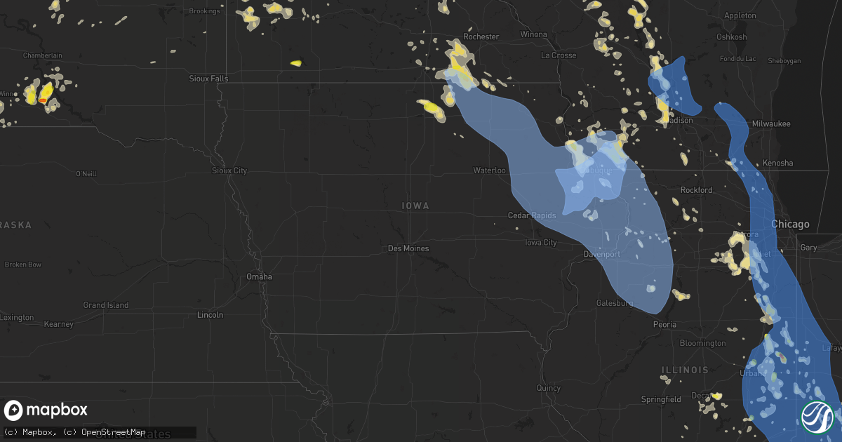
Hail Map in Iowa on June 30, 2019
Get this storm
June 30 map
$229
one time, instant access
Download today. No call, no setup
Keep the $229
Bought the map and want the full workflow? Apply the entire $229 to a subscription within 7 days. None of it is wasted.
Every map, not just this one
This buys you this map. Subscription and you get every map we run, in the markets you choose from a few cities to whole states to nationwide. Plus real-time alerts the moment a storm fires.
Contact data
Name, contact info, occupancy, even credit band for addresses in the footprint. You go from where it hit to who to call.
Become the source they trust
Unlimited branding weather history reports on demand. You already have the documented answer ready for the property owner, and you are the one who showed up with it.
Property data and RoofTrace estimates
Pull up any address you have got, its value and the exact code rules for that jurisdiction, straight from One Click Code. Then RoofTrace estimates the squares, pitch, and roof value, priced the way you price.
Storm reports in Iowa
Iowa
| Date | Description |
|---|---|
| 06/30/20196:48 PM CDT | Lost 8-inch diameter tree. |
| 06/30/20196:45 PM CDT | Shed lost. |
| 06/30/20196:45 PM CDT | 8-10 inch diameter branches down; 1.7 inches of rain. |
| 06/30/20196:45 PM CDT | 2-3 inch tree limbs down; time estimated by spotter. |
| 06/30/20196:44 PM CDT | Numerous tree limbs down 2 to 4 inches in diameter. One dented a car. |
| 06/30/20196:43 PM CDT | Several tree limbs and power lines down throughout the town. Time estimated from radar. |
| 06/30/20196:41 PM CDT | Large 4 to 6 inch diameter branches down. Picture on social media. Time estimated from radar. |
| 06/30/20196:40 PM CDT | 10 to 12 inch tree broken off above the base and it fell onto a home. Time of the event estimating using radar. |
| 06/30/20196:38 PM CDT | Large tree branch down on house at 1624 west columbia ave. |
| 06/30/20196:37 PM CDT | 3 inch diameter tree limbs down. |
| 06/30/20196:36 PM CDT | Corrects previous tstm wnd dmg report from 1 n park view. Fence ripped out and patio thrown into a pool. Reported at 18360 272nd s. |
| 06/30/20196:35 PM CDT | Facebook photo of part of roof blown off an automotive repair shop. Time estimated from radar. |
| 06/30/20196:32 PM CDT | A local report indicates 62 MPH wind near 4 SSE MAYSVILLE |
| 06/30/20196:22 PM CDT | A local report indicates 67 MPH wind near 2 W DIXON |
| 06/30/20196:20 PM CDT | Facebook photo of machine shed/shop totally destroyed. Also damage to house... Other sheds... And trees. One shed with a large overhead door bowed out. Time estimated f |
| 06/30/20196:20 PM CDT | Iadot site |
| 06/30/20196:16 PM CDT | Delayed report from social media. Time estimated from radar. Considerable trees down with highway 136 closed. Power out. |
| 06/30/20196:15 PM CDT | Late report relayed by coop observer. Roof off 2 barns. Corn crib destroyed. Trees down. One tree on deck. Time estimated. |
| 06/30/20196:13 PM CDT | Widespread thunderstorm wind damage across jones county with numerous tree downs and limbs throught the county. A roof blown off a shed in olin. |
| 06/30/20196:11 PM CDT | A local report indicates 65 MPH wind near 2 ESE CLINTON |
| 06/30/20196:10 PM CDT | 5 minutes of 50 to 60 mph winds. |
| 06/30/20196:08 PM CDT | Numerous tree damage in town. |
| 06/30/20196:08 PM CDT | Numerous tree limbs down and small debris in the air. Most limbs were 2 to 4 inches in diameter. |
| 06/30/20196:05 PM CDT | Located on the hill in town. |
| 06/30/20196:04 PM CDT | Measured at rwis iadot. |
| 06/30/20196:02 PM CDT | Trees down on highway 52 near bellevue. |
| 06/30/20195:56 PM CDT | Numerous tree branches down... Time estimated from radar. |
| 06/30/20195:54 PM CDT | Roofs ripped off multiple buildings in town. |
| 06/30/20195:49 PM CDT | Numerous tree limbs some 4 inches in diameter. |
| 06/30/20195:45 PM CDT | A local report indicates 65 MPH wind near 2 NE MARION |
| 06/30/20195:44 PM CDT | A local report indicates 76 MPH wind near DUBUQUE REGIONAL ARPT |
| 06/30/20195:43 PM CDT | Numerous reports of branches down some as large as 5 inches in diameter. A couple reports of trees about 12 to 24 inches in diameter snapped off 3 feet off the ground. |
| 06/30/20195:42 PM CDT | Power lines down between luxemburg and holy cross. |
| 06/30/20195:42 PM CDT | Two sheds blown over in town. Time estimated using radar. |
| 06/30/20195:41 PM CDT | *** 1 inj *** delayed report from social media. Time estimated from radar. Scanner reports of a barn rolling over trapping a person. |
| 06/30/20195:40 PM CDT | 1 tree uprooted and across road near 27240 183rd ave. Time estimated from radar. |
| 06/30/20195:36 PM CDT | *** 1 inj *** barn partially destroyed and trees snapped off. Time estimated by radar. |
| 06/30/20195:30 PM CDT | Numerous tree limbs down. Some 4 inches. |
| 06/30/20195:28 PM CDT | *** 2 inj *** anchored mobile home destroyed. Time estimated by radar. |
| 06/30/20195:18 PM CDT | Large tree down blocking rural road north of masonville. |
| 06/30/20195:17 PM CDT | A local report indicates 60 MPH wind near NEW VIENNA |
| 06/30/20195:17 PM CDT | Tree limbs down in town. |
| 06/30/20195:11 PM CDT | Roof blow off a house in town. |
| 06/30/20195:10 PM CDT | Corrects previous tstm wnd dmg report from independence. Numerous reports of branches down some as large as 5 inches in diameter. A couple reports of trees about 12 to |
| 06/30/20195:10 PM CDT | Delayed report via social media. Time estimated from radar. Trees down. |
| 06/30/20195:10 PM CDT | Tree limbs and utility lines down. |
| 06/30/20195:07 PM CDT | Numerous trees down in town... Time estimated from radar. |
| 06/30/20195:02 PM CDT | Corrects previous tstm wnd dmg report from 1 s hazleton. Large tree limb down in fontana park. Two foot diameter tree down in the park with numerous other trees down. |
| 06/30/20195:01 PM CDT | Reported numerous trees down in edgewood. |
| 06/30/20195:00 PM CDT | Large 30-40 foot cedar trees snapped approx 2-3 foot from base of tree. Also small outbuilding destroyed. Reported at 2214 108th st hazelton... Ia. |
| 06/30/20194:56 PM CDT | 12-24 inch tree snapped 3 feet above the ground. Relayed via dvn. Time estimated based on radar. |
| 06/30/20194:55 PM CDT | Tree snapped from estimated 60 mph wind gust. Report via wfo davenport. |
| 06/30/20194:52 PM CDT | Numerous branches and power lines down... Especially on northeast side of town. |
| 06/30/20194:52 PM CDT | A local report indicates 59 MPH wind near 4 W STANLEY |
| 06/30/20194:46 PM CDT | Trees blown down near garnavillo. |
| 06/30/20194:44 PM CDT | Tree limb blown down on a house. |
| 06/30/20194:43 PM CDT | Report of a large tree branch down on a home. |
| 06/30/20194:41 PM CDT | Trees down 1 mile south of gunder. Relayed via broadcast media. |
| 06/30/20194:40 PM CDT | Reports of some trees... Branches... And power lines down in at least four communities across the county including randalia. |
| 06/30/20194:40 PM CDT | Lots of trees and power lines down across the northern part of the county. Too many reports to relay specific locations. |
| 06/30/20194:38 PM CDT | Lots of trees blown down across the entire county. Too many reports to relay specific locations. |
| 06/30/20194:37 PM CDT | Severe roof damage to a large metal building. Boards driven into a nearby shed. Report received via social media. Time estimated based on radar. |
| 06/30/20194:35 PM CDT | This is a delayed report. Nws employee relayed storm damage... Trees snapped and uprooted... From roughly 2 south of horton. Path continued for about 3 miles to the sou |
| 06/30/20194:29 PM CDT | Tree down on highway 76 between effigy mounds and marquette. Relayed via ia dot. Time estimated based on radar. |
| 06/30/20194:24 PM CDT | Trees blown down in monona. |
| 06/30/20194:15 PM CDT | Large tree snapped in calmar. Reported via social media. Time estimated based on radar. |
| 06/30/20194:14 PM CDT | Personal weather station. Report via wfo des moines. |
| 06/30/20194:05 PM CDT | Shingles blown off. |
| 06/30/20194:05 PM CDT | Tree branch snapped in new hampton. Time estimated based on radar and arrival of storm outflow. |
| 06/30/20193:53 PM CDT | Mping report 31 miles north of frederika... Ia... Of downed trees and a roof blown off of unknown building type. |
| 06/30/20193:50 PM CDT | Tree blown down. |
| 06/30/20193:48 PM CDT | Trees blown down. |
| 06/29/201911:56 PM CDT | At 456 PM CDT, a severe thunderstorm was located over Mason City, moving southeast at 40 mph. HAZARD...60 mph wind gusts and penny size hail. SOURCE...Radar indicated. IMPACT...Expect damage to roofs, siding, and trees. Locations impacted include... Mason City, Nora Springs, Rockwell, Mason City Municipal Airport, Clear Lake, Plymouth, Swaledale, Rock Falls, Dougherty, Burchinal, Portland and Clear Lake State Park.This includes Interstate 35 between mile markers 184 and 201. |
| 06/29/201911:39 PM CDT | At 437 PM CDT, severe thunderstorms were located along a line extending from 7 miles east of Boscobel to near McGregor, moving southeast at 30 mph. HAZARD...60 mph wind gusts and penny size hail. SOURCE...Law enforcement. At 411 PM CDT, a tree was reported blown down near Mount Sterling. IMPACT...Expect damage to roofs, siding, and trees. Severe thunderstorms will be near... Fennimore and Bloomington around 455 PM CDT. Cassville around 515 PM CDT.Other locations impacted by these severe thunderstorms includeArthur, Montfort, Beetown, Nelson Dewey State Park, LancasterMunicipal Airport, Georgetown and Bagley. |
| 06/29/201911:27 PM CDT | At 426 PM CDT, a severe thunderstorm was located near Fredericksburg, or 12 miles south of New Hampton, moving south at 35 mph. HAZARD...60 mph wind gusts. SOURCE...Public. Home weather station just west of Fredericksburg reported a wind gust 65 mph. IMPACT...Expect damage to roofs, siding, and trees. Locations impacted include... Waterloo, Cedar Falls, Waverly, Allison, Sumner, Parkersburg, Denver, Clarksville, Tripoli, Shell Rock, Greene, Aplington, Waterloo Municipal Airport, Janesville, Dunkerton, Readlyn, Dumont, New Hartford, Plainfield and Frederika. |
| 06/29/201911:15 PM CDT | At 414 PM CDT, severe thunderstorms were located along a line extending from 13 miles west of Richland Center to 7 miles east of Harpers Ferry, moving southeast at 35 mph. HAZARD...60 mph wind gusts and penny size hail. SOURCE...Radar indicated. IMPACT...Expect damage to roofs, siding, and trees. Severe thunderstorms will be near... Muscoda around 440 PM CDT.Other locations impacted by these severe thunderstorms includeEastman, Highway 61 And County T, Horrigan Ridge, Eagle Corners,County Roads K And T, Bridgeport and Fairview. |
| 06/29/201910:07 PM CDT | At 306 PM CDT, a severe thunderstorm was located over Rose Creek, or 7 miles southeast of Austin, moving southeast at 35 mph. HAZARD...60 mph wind gusts. SOURCE...Radar indicated. IMPACT...Expect damage to roofs, siding, and trees. This severe thunderstorm will be near... Adams around 315 PM CDT.Other locations impacted by this severe thunderstorm include CountyRoads 56 And 5, County Roads 4 And 8, I 90 Exit 187, Elkton, I 90Exit 189, I 90 Exit 183 and Lake Louise State Park. |
| 06/29/20199:52 PM CDT | At 251 PM CDT, a severe thunderstorm was located near Brewster, or 12 miles northeast of Worthington, moving east at 30 mph. HAZARD...60 mph wind gusts and half dollar size hail. SOURCE...Radar indicated. IMPACT...Hail damage to vehicles is expected. Expect wind damage to roofs, siding, and trees. This severe thunderstorm will be near... Heron Lake around 255 PM CDT. Lakefield around 315 PM CDT. Kilen Woods State Park around 325 PM CDT. Jackson In Jackson County around 330 PM CDT.Other locations impacted by this severe thunderstorm include Alphaand Okabena. |
| 06/29/20199:52 PM CDT | At 252 PM CDT, a severe thunderstorm was located 8 miles southeast of Hayfield, or 16 miles northeast of Austin, moving southeast at 50 mph. HAZARD...60 mph wind gusts. SOURCE...Radar indicated. IMPACT...Expect damage to roofs, siding, and trees. This severe thunderstorm will be near... Grand Meadow around 305 PM CDT. Spring Valley around 315 PM CDT.Other locations impacted by this severe thunderstorm includeForestville State Park, Oslo, Etna, Sargeant, York, County Roads 1And 7 and Cherry Grove. |
| 06/29/20197:39 PM CDT | A local report indicates 58 MPH wind near BURLINGTON REGIONAL AIR |
All States Impacted by Hail Map on June 30, 2019
Cities Impacted by Hail Map on June 30, 2019
- Shakopee, MN
- Jordan, MN
- Stockton, IL
- Hill City, SD
- Walnut Grove, MN
- Midkiff, TX
- Newark, IL
- Minooka, IL
- Channahon, IL
- Shorewood, IL
- Morris, IL
- Miller, SD
- Adams, MN
- Nashville, IN
- McCamey, TX
- Crane, TX
- Sebring, FL
- Argenta, IL
- Cerro Gordo, IL
- Bremen, ME
- Bristol, ME
- Cranston, RI
- West Warwick, RI
- Hope, RI
- Warwick, RI
- Johnston, RI
- East Greenwich, RI
- Kyle, SD
- Elkton, SD
- Ottertail, MN
- Richville, MN
- Gaylord, MN
- Cologne, MN
- Hamburg, MN
- Norwood Young America, MN
- Henderson, MN
- Glencoe, MN
- Green Isle, MN
- Plato, MN
- Arlington, MN
- Young America, MN
- Spencer, SD
- Middleboro, MA
- Kendall, WI
- Saint Joseph, IL
- New Richland, MN
- Waseca, MN
- Kansas, IL
- Gregory, SD
- Dallas, SD
- Burke, SD
- Winner, SD
- Hamill, SD
- Bloomington, IN
- Ellettsville, IN
- Lodi, WI
- Dane, WI
- Prairie Du Sac, WI
- Madison, WI
- Waunakee, WI
- Sauk City, WI
- Mount Horeb, WI
- Mazomanie, WI
- Verona, WI
- Middleton, WI
- Cross Plains, WI
- Hume, IL
- Metcalf, IL
- Lee, IL
- Aurora, IL
- Montgomery, IL
- Yorkville, IL
- Oswego, IL
- Sugar Grove, IL
- Plano, IL
- Big Rock, IL
- Bristol, IL
- Fairbanks, IN
- Shelburn, IN
- Wellington, IL
- Hoopeston, IL
- Lodge Grass, MT
- Cheyenne, WY
- Jasper, IN
- Walworth, WI
- Williams Bay, WI
- Fontana, WI
- Lake Geneva, WI
- Delavan, WI
- Otter, MT
- Orfordville, WI
- Imperial, TX
- Ashkum, IL
- Mattoon, IL
- Lance Creek, WY
- Big Timber, MT
- Scales Mound, IL
- Rewey, WI
- Bloomington, WI
- Mineral Point, WI
- Platteville, WI
- Benton, WI
- Shullsburg, WI
- Highland, WI
- Belmont, WI
- Livingston, WI
- Linden, WI
- Dodgeville, WI
- Fennimore, WI
- Mount Hope, WI
- Lancaster, WI
- Cuba City, WI
- Potosi, WI
- Darlington, WI
- Marengo, IL
- Lewellen, NE
- Arthur, NE
- Salem, IN
- Campbellsburg, IN
- West Point, KY
- Muldraugh, KY
- Lewisport, KY
- Wisconsin Rapids, WI
- Oakland, IL
- Garrison, MN
- Wahkon, MN
- Onamia, MN
- Red Wing, MN
- Sidney, NE
- Macon, IL
- Boody, IL
- Moweaqua, IL
- Brazil, IN
- Pekin, IN
- Borden, IN
- Campton, KY
- Russell, MN
- Tyler, MN
- Rossville, IL
- Williamsport, IN
- Hendricks, MN
- Evansville, WI
- Beloit, WI
- Brodhead, WI
- Cornell, WI
- Holcombe, WI
- Peetz, CO
- Mooresville, IN
- Montgomery, IN
- Fredericksburg, IN
- Verndale, MN
- Black River Falls, WI
- Platte, SD
- Seneca, IL
- Parmelee, SD
- Saint Francis, SD
- Sheridan, WY
- Camden, AR
- Lime Springs, IA
- Chester, IA
- Le Roy, MN
- Sparland, IL
- Henry, IL
- Varna, IL
- Lacon, IL
- Toluca, IL
- Weldona, CO
- Merrillan, WI
- Mason City, IA
- Manly, IA
- Pierz, MN
- Hillman, MN
- Onida, SD
- Fairfax, MN
- Franklin, MN
- Frankfort, KY
- Spearsville, LA
- Lamberton, MN
- Norwalk, WI
- Sparta, WI
- Tomah, WI
- Wilton, WI
- Rochdale, MA
- North Oxford, MA
- Auburn, MA
- Freedom, IN
- Coal City, IN
- White, SD
- Cannon Falls, MN
- Grover, CO
- Farmingville, NY
- Holtsville, NY
- Penfield, IL
- Loda, IL
- Ludlow, IL
- Cissna Park, IL
- Rankin, IL
- Potomac, IL
- Buckley, IL
- Paxton, IL
- Hardinsburg, IN
- Rice, MN
- Sauk Rapids, MN
- Springfield, KY
- Saint Catharine, KY
- Fort Morgan, CO
- Keenesburg, CO
- Roggen, CO
- Watertown, WI
- Jay Em, WY
- Fort Laramie, WY
- Bonfield, IL
- Kankakee, IL
- East Islip, NY
- Oakdale, NY
- Great River, NY
- Oregon, IL
- Chana, IL
- Ashton, IL
- Palm Bay, FL
- Melville, MT
- Newcastle, WY
- Seymour, IN
- Elizabethtown, IN
- Columbus, IN
- Seaforth, MN
- Vesta, MN
- Sacred Heart, MN
- Danube, MN
- Hanley Falls, MN
- Cottonwood, MN
- Olivia, MN
- Belview, MN
- Echo, MN
- Morton, MN
- Redwood Falls, MN
- Renville, MN
- Wood Lake, MN
- Wabasso, MN
- Salem, SD
- Winfred, SD
- Montrose, SD
- Marion, LA
- Lebanon, SD
- Mora, MN
- Ogilvie, MN
- Hanover, IN
- Nabb, IN
- Lexington, IN
- Hager City, WI
- Lead, SD
- Dubuque, IA
- Durango, IA
- Cassville, WI
- Holy Cross, IA
- Glen Haven, WI
- North Buena Vista, IA
- Wanblee, SD
- Interior, SD
- Kadoka, SD
- Wood Lake, NE
- Granite Falls, MN
- Gays Mills, WI
- Amana, IA
- Carbon, IN
- Rosedale, IN
- Reelsville, IN
- Bedford, IN
- Custer, SD
- Greencastle, IN
- Ideal, SD
- La Motte, IA
- Bellevue, IA
- Ruthton, MN
- Keystone, SD
- Siren, WI
- Charleston, IL
- Sterling City, TX
- Eagle Bend, MN
- Kimball, SD
- New York Mills, MN
- Sutton, MA
- Oxford, MA
- Belfry, KY
- Sidney, KY
- Austin, MN
- Kersey, CO
- Homer, IL
- Fairmount, IL
- Fithian, IL
- Big Lake, TX
- Brandt, SD
- Hinckley, MN
- Grantsburg, WI
- Pine City, MN
- Camp Douglas, WI
- Rockville, IN
- Cody, NE
- Nenzel, NE
- Kilgore, NE
- New Prague, MN
- Chrisman, IL
- Franktown, CO
- Castle Rock, CO
- Thorp, WI
- Greenwood, WI
- Clear Lake, SD
- Crow Agency, MT
- Vesper, WI
- Conrath, WI
- Madison, MN
- Toronto, SD
- Arco, MN
- Brookings, SD
- Minneota, MN
- Ivanhoe, MN
- Bruce, SD
- Ellsworth, NE
- Bingham, NE
- Elsie, NE
- Attica, IN
- Covington, IN
- West Lebanon, IN
- Realitos, TX
- Upton, WY
- Oxford, WI
- Endeavor, WI
- Orlando, FL
- Moore Haven, FL
- Clewiston, FL
- Athol, MA
- Petersham, MA
- Osage, WY
- Somerset, WI
- Holland, MN
- Lake Benton, MN
- Balaton, MN
- Woodstock, MN
- Springfield, MN
- Spring Green, WI
- Plain, WI
- Milford, IL
- Merriman, NE
- Whitman, NE
- Veteran, WY
- Waltham, MN
- Bohemia, NY
- Islip Terrace, NY
- Central Islip, NY
- Sayville, NY
- Brentwood, NY
- Islandia, NY
- Hauppauge, NY
- Islip, NY
- West Sayville, NY
- Reed Point, MT
- Freeport, MN
- Albany, MN
- Canby, MN
- Gary, SD
- Estelline, SD
- Astoria, SD
- Remer, MN
- Kimball, MN
- South Hamilton, MA
- Essex, MA
- Long Valley, SD
- Alvin, IL
- Danville, IL
- Georgetown, IL
- Cayuga, IN
- Hillsdale, IN
- Dana, IN
- Ridge Farm, IL
- Joliet, IL
- Plainfield, IL
- Elkhart, IL
- Lingle, WY
- Flat Lick, KY
- Barbourville, KY
- Nekoosa, WI
- Port Edwards, WI
- Hollis, NH
- Orleans, IN
- Ellsworth, WI
- Bay City, WI
- Glen Flora, WI
- Hardin, MT
- Hayward, MN
- Herrick, SD
- Finlayson, MN
- McGrath, MN
- Withee, WI
- Owen, WI
- Lublin, WI
- Fairbury, IL
- Adams, WI
- Friendship, WI
- Okabena, MN
- Merrimac, WI
- Portage, WI
- Baraboo, WI
- Lagrange, WY
- Orchard, CO
- Deer Creek, MN
- Henning, MN
- Norris, SD
- Wonewoc, WI
- Cazenovia, WI
- Suffolk, VA
- Herman, MN
- Briggsville, WI
- Grand Marsh, WI
- Wisconsin Dells, WI
- Hill City, MN
- Wadena, MN
- Sebeka, MN
- Hillpoint, WI
- Marshall, MN
- Bethany, IL
- Hastings, MN
- Valentine, NE
- Sleepy Eye, MN
- Morgan, MN
- Ellendale, MN
- Poland, IN
- Cloverdale, IN
- Spencer, IN
- Versailles, KY
- Danforth, IL
- Neillsville, WI
- Granton, WI
- Brooklyn, WI
- Centerpoint, IN
- Crest Hill, IL
- Elwood, IL
- Sarona, WI
- Birchwood, WI
- Frederic, WI
- Fenton, IL
- Morrison, IL
- Stoneham, CO
- Palisade, MN
- Mahomet, IL
- Fisher, IL
- Tracy, MN
- Wheatland, WY
- Bighorn, MT
- Grand Rapids, MN
- Forsyth, MT
- Ashland, MT
- Lame Deer, MT
- Billerica, MA
- Burlington, MA
- New Raymer, CO
- Williamsburg, VA
- Champaign, IL
- Thomasboro, IL
- Urbana, IL
- Sherrill, IA
- Brewster, MN
- Lakefield, MN
- Longville, MN
- West Union, IL
- Birney, MT
- Hammond, IL
- Shoals, IN
- Loogootee, IN
- Eastman, WI
- Wilmington, IL
- Elroy, WI
- Sidell, IL
- Osage, IA
- Marseilles, IL
- Sheridan, IL
- Torrington, WY
- Warrens, WI
- Hayfield, MN
- Dorchester, WI
- Abbotsford, WI
- Curtiss, WI
- Colby, WI
- Spencer, WI
- Unity, WI
- Vineyard Haven, MA
- Edgartown, MA
- Prior Lake, MN
- Lakeville, MN
- Manville, WY
- Lusk, WY
- Dexter, MN
- Lyle, MN
- Brownsdale, MN
- Rose Creek, MN
- McIntire, IA
- Blooming Prairie, MN
- Riceville, IA
- Elkton, MN
- Taopi, MN
- Sargeant, MN
- Stacyville, IA
- Dodge Center, MN
- Ferryville, WI
- Soldiers Grove, WI
- Mount Morris, IL
- Leaf River, IL
- German Valley, IL
- Bird Island, MN
- Belle Plaine, MN
- Alpena, SD
- Racine, MN
- Albert Lea, MN
- Grand Meadow, MN
- Saint Ansgar, IA
- Claremont, MN
- Stewartville, MN
- Glenville, MN
- Little Cedar, IA
- Kasson, MN
- Mitchell, IN
- Sullivan, IN
- Farmersburg, IN
- Elizabeth, IN
- Fort Knox, KY
- Corydon, IN
- Laconia, IN
- Lancaster, KY
- Hanlontown, IA
- Kensett, IA
- Wood, SD
- Presho, SD
- Pukwana, SD
- Hillsboro, WI
- Haxtun, CO
- Fleming, CO
- Gann Valley, SD
- Wyoming, IL
- Commack, NY
- Smithtown, NY
- South Wayne, WI
- Aitkin, MN
- Webster, MN
- Witten, SD
- White River, SD
- Mission, SD
- Okreek, SD
- Harmon, IL
- Waldoboro, ME
- Dawson, MN
- Ramsey, IN
- Belle Plaine, IA
- Hampton, AR
- Brainerd, MN
- Menomonie, WI
- Boulder, CO
- Nederland, CO
- Billings, MT
- Solsberry, IN
- Bloomfield, IN
- Junction, TX
- Sparks, NE
- Isle, MN
- Nerstrand, MN
- Kenyon, MN
- Lillie, LA
- Chebanse, IL
- Herscher, IL
- Swatara, MN
- Outing, MN
- East Northport, NY
- Ronkonkoma, NY
- Northport, NY
- Kings Park, NY
- Colome, SD
- Akron, CO
- Willard, WI
- Marshfield, WI
- Chili, WI
- San Diego, TX
- Stitzer, WI
- Ridgefield, CT
- Danbury, CT
- Chugwater, WY
- Mattapoisett, MA
- Amelia Court House, VA
- Rapid City, SD
- New Richmond, WI
- Hudson, WI
- Arkdale, WI
- Babcock, WI
- Pittsville, WI
- Necedah, WI
- Clear Lake, IA
- Nora Springs, IA
- Rock Falls, IL
- Goodwin, SD
- Otisco, IN
- Marysville, IN
- Clifton, IL
- Cabery, IL
- Savage, MN
- Sundance, WY
- Holmes, NY
- Patterson, NY
- Brewster, NY
- Redding, CT
- Cascade, IA
- Epworth, IA
- Bernard, IA
- Meriden, WY
- Burns, WY
- Weston, CT
- Gillette, WY
- Lawrenceburg, KY
- Loyal, WI
- Hebron, IL
- Richmond, IL
- Wonder Lake, IL
- Guttenberg, IA
- Madison, IN
- Spragueville, IA
- Maquoketa, IA
- Andrew, IA
- Arlington, SD
- Marshall, IL
- Leopold, IN
- Sulphur, IN
- English, IN
- Leavenworth, IN
- Boston, KY
- Putnamville, IN
- Fillmore, IN
- Jolo, WV
- Carson, VA
- Dinwiddie, VA
- Stanley, WI
- Ree Heights, SD
- Milton, NY
- Prophetstown, IL
- Clarkfield, MN
- Taunton, MN
- Harmony, MN
- Paragon, IN
- Tony, WI
- McGregor, IA
- Harpers Ferry, IA
- Monona, IA
- Browerville, MN
- Harris, MN
- North Branch, MN
- Milan, MN
- Paris, IL
- Ashmore, IL
- Brocton, IL
- Strasburg, IL
- Serena, IL
- Gilman, IL
- Onarga, IL
- Armstrong, IL
- Tinley Park, IL
- Milaca, MN
- Foreston, MN
- Rockton, IL
- Coatesville, IN
- Dubois, IN
- Haynesville, LA
- Eros, LA
- Calhoun, LA
- West Monroe, LA
- Pine Bluffs, WY
- Ohio, IL
- Hyden, KY
- Scenic, SD
- Marshall, IN
- Bloomingdale, IN
- Little Falls, MN
- Peosta, IA
- Farley, IA
- Slayton, MN
- Garvin, MN
- Waveland, IN
- Strong, AR
- El Dorado, AR
- Nokomis, IL
- Cannelton, IN
- Derby, IN
- Kennan, WI
- Owatonna, MN
- Chamberlain, SD
- Steward, IL
- Wiggins, CO
- La Place, IL
- Castlewood, SD
- Okeechobee, FL
- Palmyra, IN
- Hoffman, MN
- Snyder, CO
- Otis, CO
- Chidester, AR
- Farmerville, LA
- Monroe, LA
- Prudence Island, RI
- Watseka, IL
- Ottawa, IL
- Westport, CT
- Wilton, CT
- Verona, IL
- Mazon, IL
- Gifford, IL
- Ogden, IL
- Elburn, IL
- Geneva, IL
- Leola, AR
- Oakwood, IL
- Lost Nation, IA
- Delmar, IA
- Orange Grove, TX
- Farwell, MN
- Welch, MN
- Lynd, MN
- Milroy, MN
- Springview, NE
- Centereach, NY
- Rawlings, VA
- Hector, MN
- Lake Wilson, MN
- New Washington, IN
- Oak Park, MN
- Sanborn, MN
- Arena, WI
- Barneveld, WI
- Blue Mounds, WI
- Carpenter, WY
- New Auburn, WI
- Jim Falls, WI
- Bruce, WI
- Bloomer, WI
- Glendo, WY
- Fulton, IL
- Albany, IL
- Erie, IL
- Clinton, IA
- Mansfield, IL
- Shongaloo, LA
- Tilton, IL
- Buffalo Lake, MN
- Braceville, IL
- Coal City, IL
- Braidwood, IL
- Kingman, IN
- Darien, WI
- Avalon, WI
- Gratiot, WI
- Ortonville, MN
- Clinton, MN
- Harrisburg, NE
- Pine Island, MN
- Byron, MN
- Lake Villa, IL
- Antioch, IL
- Tuthill, SD
- Allerton, IL
- Crescent City, IL
- Buckingham, IL
- Vero Beach, FL
- Yoder, WY
- Hulett, WY
- Grand Mound, IA
- Cambridge, MN
- Hampton, MN
- Lone Rock, WI
- Avoca, WI
- Sterling, CO
- Nicholasville, KY
- Wilmore, KY
- Kilkenny, MN
- Coyanosa, TX
- Boyd, MN
- Davenport, IA
- Bradford, IL
- Gibson City, IL
- Evanston, IN
- Lamar, IN
- Grandview, IN
- Staples, MN
- Pearl City, IL
- Rantoul, IL
- Burtrum, MN
- Shrewsbury, MA
- Milltown, IN
- Depauw, IN
- Cavour, SD
- Warren, IL
- Nora, IL
- Lena, IL
- Mathis, TX
- Northfield, MN
- Winchester, KY
- Saint Lawrence, SD
- Garnavillo, IA
- New Vienna, IA
- Colesburg, IA
- Morris, MN
- Hancock, MN
- Tuscola, IL
- Custer, MT
- Loganville, WI
- Fort Thompson, SD
- Poynette, WI
- Austin, IN
- Battle Lake, MN
- Martinsville, IN
- Monrovia, IN
- Lerna, IL
- Emily, MN
- Strandburg, SD
- Hyannis, NE
- Elmwood, WI
- Harrodsburg, KY
- Carver, MN
- Colman, SD
- Flandreau, SD
- Marion, MA
- Long Prairie, MN
- Swanville, MN
- Lucan, MN
- Coxs Creek, KY
- Plympton, MA
- Halifax, MA
- Hancock, WI
- Palestine, IL
- Newman, IL
- Villa Grove, IL
- Murdock, IL
- Camargo, IL
- Richmond, KY
- Hurley, VA
- Hawkins, WI
- Decorah, IA
- Bowlus, MN
- Royalton, MN
- Appleton, MN
- Crystal Lake, IL
- Mchenry, IL
- Island Lake, IL
- Lovington, IL
- Decatur, IL
- Crookston, NE
- Longview, IL
- Sidney, IL
- Broadlands, IL
- Owaneco, IL
- Pana, IL
- Greenup, IL
- Dalton City, IL
- Scottsburg, IN
- North Freedom, WI
- Eldridge, IA
- Long Grove, IA
- Margarettsville, NC
- Donnelly, MN
- Lanark, IL
- Mount Carroll, IL
- Bowling Green, IN
- Busy, KY
- Joice, IA
- Rockford, IA
- Fertile, IA
- Sauk Centre, MN
- Belvidere, SD
- Grafton, IA
- Northwood, IA
- Carpenter, IA
- Plymouth, IA
- Branchville, IN
- Toulon, IL
- Medford, WI
- Geneseo, IL
- Pardeeville, WI
- Alden, MN
- Hartland, MN
- Bismarck, IL
- Montezuma, IN
- Ladysmith, WI
- Gilman, WI
- Mount Pulaski, IL
- Emington, IL
- Goldsmith, TX
- Dalton, NE
- Lebanon Junction, KY
- Ghent, MN
- Baldwin, IA
- Charlton, MA
- Trafalgar, IN
- Clermont, KY
- Shepherdsville, KY
- Mount Washington, KY
- McKenney, VA
- Eldena, IL
- Dixon, IL
- Fillmore, IL
- Paoli, IN
- Barronett, WI
- Deforest, WI
- Cadott, WI
- Boyd, WI
- Lodgepole, NE
- Crook, CO
- Bagley, WI
- Dix, NE
- Indianola, IL
- Unionville, IN
- Morgantown, IN
- Faribault, MN
- Dennison, MN
- Mundelein, IL
- Grayslake, IL
- Readstown, WI
- Amherst, NH
- Milford, NH
- Janesville, WI
- Underwood, MN
- Woonsocket, SD
- Huron, SD
- Artesian, SD
- Wessington Springs, SD
- Milton, WI
- Bangs, TX
- Santa Anna, TX
- Avon, MN
- Holdingford, MN
- Wallace, NE
- Humboldt, IL
- West Baden Springs, IN
- Boswell, IN
- Bardstown, KY
- Elko New Market, MN
- Farmington, MN
- Pierre, SD
- Salem, WI
- West Terre Haute, IN
- Deputy, IN
- Rosemount, MN
- Wauzeka, WI
- Greene, IA
- Lake Placid, FL
- Fellsmere, FL
- Eau Galle, WI
- Colfax, IL
- Cropsey, IL
- Crewe, VA
- Hazel Green, WI
- Stafford Springs, CT
- Somers, CT
- Bainbridge, IN
- Sheldon, WI
- Wessington, SD
- Merino, CO
- Freeport, IL
- Shannon, IL
- Bushnell, NE
- Downing, WI
- Knapp, WI
- Boyceville, WI
- Clarissa, MN
- Stacy, MN
- Gravel Switch, KY
- Cresco, IA
- Poughquag, NY
- Gays, IL
- Clay City, IN
- Cannelburg, IN
- Grey Eagle, MN
- French Lick, IN
- Gray, KY
- Corbin, KY
- Rochelle, IL
- Athens, IL
- Greenview, IL
- Middletown, IL
- Wall, SD
- Galena, IL
- Taylorsville, KY
- Star Prairie, WI
- Ford, VA
- Lowry, MN
- Starbuck, MN
- Spring Valley, MN
- Ostrander, MN
- Worthington, IN
- Stilesville, IN
- Chaska, MN
- Bristow, IN
- Mcgregor, MN
- Sartell, MN
- Saint Stephen, MN
- Mt Zion, IL
- Mertzon, TX
- Birdseye, IN
- Stewart, MN
- East Troy, WI
- Fairchild, WI
- Arlington, WI
- Fairfield, CT
- Sandwich, IL
- Romeoville, IL
- Essex, IL
- Manhattan, IL
- Millington, IL
- Lockport, IL
- Savanna, IL
- Barrington, IL
- Wauconda, IL
- Wedron, IL
- Brownwood, TX
- Bena, MN
- Deer River, MN
- Hopewell Junction, NY
- Hawk Springs, WY
- Westborough, MA
- Northborough, MA
- Oshkosh, NE
- Ashby, NE
- Saint Xavier, MT
- Greycliff, MT
- Broadus, MT
- Morrisonville, WI
- Dalton, WI
- Cambria, WI
- Deerfield, WI
- Rio, WI
- Waterloo, WI
- Sun Prairie, WI
- Marshall, WI
- Cottage Grove, WI
- Montello, WI
- Columbus, WI
- Reedsburg, WI
- Windsor, WI
- Wyocena, WI
- Edwardsport, IN
- Patoka, IN
- Webster, KY
- La Grange, IL
- Lafayette, IN
- Otterbein, IN
- Dundee, IL
- Momence, IL
- Terre Haute, IN
- Plainville, IN
- Ladoga, IN
- Fox River Grove, IL
- Libertyville, IL
- Princeton, IN
- Glendale Heights, IL
- Owensboro, KY
- Pine Village, IN
- Lombard, IL
- Fowler, IN
- Caneyville, KY
- Lowell, IN
- Mount Prospect, IL
- Hutsonville, IL
- Flat Rock, IL
- Templeton, IN
- Norman, IN
- Collison, IL
- Nashotah, WI
- Lisle, IL
- Petersburg, IN
- Tennyson, IN
- Hanover Park, IL
- Fort Branch, IN
- Perrysville, IN
- West York, IL
- Universal, IN
- Palos Park, IL
- Garfield, KY
- Sheldon, IL
- Summit Argo, IL
- Philo, IL
- Olaton, KY
- Big Clifty, KY
- Washington, IN
- Goodland, IN
- Okauchee, WI
- Merom, IN
- Eastview, KY
- Knightsville, IN
- Hinsdale, IL
- Evansville, IN
- West Chicago, IL
- New Market, IN
- Scotland, IN
- Oconomowoc, WI
- Medora, IN
- Clinton, IN
- Park Forest, IL
- Chandler, IN
- Oaktown, IN
- Romney, IN
- Elberfeld, IN
- Carpentersville, IL
- Trevor, WI
- Savoy, IL
- Beaverville, IL
- New Richmond, IN
- Grant Park, IL
- Santa Claus, IN
- Gosport, IN
- Villa Park, IL
- Earl Park, IN
- Pewaukee, WI
- Ambia, IN
- Monroe City, IN
- Hymera, IN
- Wingate, IN
- Manteno, IL
- Pembroke Township, IL
- West Lafayette, IN
- Iroquois, IL
- Waynetown, IN
- Casey, IL
- Newburgh, IN
- Westville, IL
- Grantsburg, IN
- Cynthiana, IN
- Pimento, IN
- Henning, IL
- Cary, IL
- Payneville, KY
- Sandborn, IN
- Hillsboro, IN
- Stendal, IN
- Darien, IL
- Willowbrook, IL
- Franklin Park, IL
- Waukesha, WI
- Fordsville, KY
- Holland, IN
- Twin Lakes, WI
- Jasonville, IN
- Haubstadt, IN
- Winfield, IL
- Schaumburg, IL
- Ringwood, IL
- Harmony, IN
- Remington, IN
- Genoa City, WI
- Palatine, IL
- Monee, IL
- Oak Brook, IL
- Justice, IL
- Russellville, IN
- Dugger, IN
- Lake Forest, IL
- Battletown, KY
- Sullivan, WI
- Burlington, WI
- Otwell, IN
- Coalmont, IN
- Annapolis, IL
- Prospect Heights, IL
- Williams, IN
- Mokena, IL
- McDaniels, KY
- Crane, IN
- Vallonia, IN
- Lincoln City, IN
- Wheeling, IL
- New Goshen, IN
- Roachdale, IN
- Rhodelia, KY
- Glenview, IL
- Guston, KY
- Union Star, KY
- Taswell, IN
- New Salisbury, IN
- Calhoun, KY
- Bartlett, IL
- Reed, KY
- Ragsdale, IN
- Robinson, IL
- Springfield, WI
- Wayne, IL
- Stone Park, IL
- Sadorus, IL
- Saint Anne, IL
- Westview, KY
- Hawesville, KY
- Catlin, IL
- Boonville, IN
- Owensville, IN
- Mukwonago, WI
- Spottsville, KY
- Roselle, IL
- Mauckport, IN
- Horse Branch, KY
- Poseyville, IN
- Lincolnshire, IL
- Westphalia, IN
- Wheaton, IL
- Deerfield, IL
- Elk Grove Village, IL
- Muncie, IL
- Saint Francisville, IL
- Lawrenceville, IL
- Hartford, KY
- Lake Zurich, IL
- Melrose Park, IL
- Wales, WI
- Naperville, IL
- Bensenville, IL
- Vermilion, IL
- Custer, KY
- Dousman, WI
- New Lenox, IL
- Ingleside, IL
- Redmon, IL
- Wheatland, IN
- Mecca, IN
- Brandenburg, KY
- Spurgeon, IN
- Freelandville, IN
- Quincy, IN
- Woodstock, IL
- Downers Grove, IL
- Dundee, KY
- Wood Dale, IL
- Harned, KY
- Owensburg, IN
- Carol Stream, IL
- Mount Vernon, IN
- Bolingbrook, IL
- Oxford, IN
- Vine Grove, KY
- Broadview, IL
- Whitesville, KY
- Wilmot, WI
- Westchester, IL
- Huntingburg, IN
- Velpen, IN
- Martinton, IL
- Newberry, IN
- Western Springs, IL
- Richton Park, IL
- Arlington Heights, IL
- Willow Springs, IL
- Winslow, IN
- Tolono, IL
- Martinsville, IL
- Westfield, IL
- Celestine, IN
- Palmyra, WI
- Lyons, IN
- Algonquin, IL
- Union Hill, IL
- Addison, IL
- La Grange Park, IL
- Maywood, IL
- Lewis, IN
- Troy, IN
- Gentryville, IN
- Bicknell, IN
- Hindsboro, IL
- Hillside, IL
- Schiller Park, IL
- Henderson, KY
- Carlisle, IN
- Rolling Meadows, IL
- North Prairie, WI
- Elmhurst, IL
- Saint Anthony, IN
- Cloverport, KY
- Oolitic, IN
- Pesotum, IL
- Switz City, IN
- Chrisney, IN
- Glen Ellyn, IL
- Brook, IN
- State Line, IN
- Medinah, IL
- Hardinsburg, KY
- Ashippun, WI
- Stockland, IL
- Rockport, IN
- Ixonia, WI
- Reynolds Station, KY
- Veedersburg, IN
- Des Plaines, IL
- Staunton, IN
- Lebanon, WI
- Dennison, IL
- Streamwood, IL
- Arcola, IL
- Aroma Park, IL
- Brookfield, IL
- Clarendon Hills, IL
- Tell City, IN
- Odon, IN
- Marengo, IN
- Linton, IN
- Ferdinand, IN
- Mellott, IN
- Wadesville, IN
- Richland, IN
- Reddick, IL
- Livermore, KY
- Leitchfield, KY
- Eagle, WI
- Elgin, IL
- Elnora, IN
- Berkeley, IL
- Dale, IN
- Allendale, IL
- Oakland City, IN
- Maceo, KY
- Westmont, IL
- Frankfort, IL
- Vernon Hills, IL
- Heltonville, IN
- Saint Meinrad, IN
- Round Lake, IL
- Lemont, IL
- Beecher, IL
- Decker, IN
- Eckerty, IN
- Orland Park, IL
- Robards, KY
- Morocco, IN
- Palos Hills, IL
- Irvington, KY
- Papineau, IL
- Woodridge, IL
- Donovan, IL
- Central, IN
- Cecilia, KY
- Fox Lake, IL
- Rome, IN
- Riley, IN
- Spring Grove, IL
- Rineyville, KY
- Crete, IL
- Stinesville, IN
- Ekron, KY
- Peotone, IL
- Lynnville, IN
- Bruceville, IN
- Hazleton, IN
- Lake Village, IN
- Tunnelton, IN
- Alamo, IN
- Hartland, WI
- Avoca, IN
- Philpot, KY
- Warrenville, IL
- Hoffman Estates, IL
- Bloomingdale, IL
- Bridgeton, IN
- Dewey, IL
- Bourbonnais, IL
- Itasca, IL
- Bradley, IL
- Northbrook, IL
- Stephensport, KY
- Francisco, IN
- Buffalo Grove, IL
- Kentland, IN
- Hickory Hills, IL
- Homer Glen, IL
- Elkhorn, WI
- Crawfordsville, IN
- Falls Of Rough, KY
- University Park, IL
- Westpoint, IN
- Royal, IL
- Schnellville, IN
- Cory, IN
- Hudson, KY
- Patricksburg, IN
- Bellwood, IL
- Springville, IN
- Delafield, WI
- Helenville, WI
- Newtown, IN
- Vincennes, IN
- Utica, KY
- Saint Croix, IN
- Matteson, IL
- Whitewater, WI
- Arlington, IA
- Mineral, IL
- Ophiem, IL
- Woodhull, IL
- Anamosa, IA
- Manlius, IL
- Plainfield, IA
- Walnut, IL
- Dixon, IA
- Center Junction, IA
- New Liberty, IA
- Floyd, IA
- Hanover, IL
- Spillville, IA
- Teeds Grove, IA
- Rock Island, IL
- Fredericksburg, IA
- Blue Grass, IA
- Dahinda, IL
- Oelwein, IA
- Le Claire, IA
- Tipton, IA
- Alta Vista, IA
- Altona, IL
- Robins, IA
- Clermont, IA
- Calmar, IA
- Urbana, IA
- Sabula, IA
- Earlville, IA
- Oxford Junction, IA
- Princeton, IA
- Coggon, IA
- Galesburg, IL
- Miles, IA
- Polo, IL
- Oneida, IL
- Victoria, IL
- Stanley, IA
- Rio, IL
- Waucoma, IA
- Kieler, WI
- Worthington, IA
- Bettendorf, IA
- Hopkinton, IA
- Postville, IA
- Carbon Cliff, IL
- Cedar Rapids, IA
- Andover, IL
- Masonville, IA
- New Bedford, IL
- Buda, IL
- Wilton, IA
- Camanche, IA
- Mount Vernon, IA
- Fairbank, IA
- New Windsor, IL
- Cordova, IL
- Laura, IL
- Williamsfield, IL
- Ridgeway, IA
- McCausland, IA
- Elizabeth, IL
- Wataga, IL
- Lowden, IA
- Speer, IL
- Saint Lucas, IA
- Aurora, IA
- Apple River, IL
- Ely, IA
- Bishop Hill, IL
- Charles City, IA
- Sterling, IL
- Shellsburg, IA
- Marion, IA
- Ossian, IA
- Jesup, IA
- Volga, IA
- Pleasant Valley, IA
- Dunlap, IL
- Cambridge, IL
- Garber, IA
- Preston, IA
- Wyanet, IL
- Durant, IA
- Luxemburg, IA
- Delaware, IA
- Mechanicsville, IA
- Lawler, IA
- East Moline, IL
- Putnam, IL
- Goose Lake, IA
- Port Byron, IL
- Knoxville, IL
- Low Moor, IA
- Deer Grove, IL
- Brandon, IA
- Castalia, IA
- Neponset, IL
- Wyoming, IA
- Silvis, IL
- Martelle, IA
- Alpha, IL
- Springville, IA
- Calamus, IA
- Walcott, IA
- Delhi, IA
- Orchard, IA
- Readlyn, IA
- Forreston, IL
- Annawan, IL
- Ionia, IA
- Lisbon, IA
- Vinton, IA
- Dickeyville, WI
- Clarence, IA
- Sherrard, IL
- Onslow, IA
- New Hampton, IA
- Montfort, WI
- Brimfield, IL
- Osco, IL
- Nashua, IA
- Elmwood, IL
- Bryant, IA
- Elma, IA
- Ryan, IA
- Monmouth, IA
- West Union, IA
- Edelstein, IL
- Wheatland, IA
- Frederika, IA
- Sheffield, IL
- Lyndon, IL
- Princeville, IL
- Maynard, IA
- De Witt, IA
- Lamont, IA
- Westgate, IA
- Manchester, IA
- Rapids City, IL
- Independence, IA
- Solon, IA
- Colona, IL
- Chillicothe, IL
- Wadena, IA
- East Dubuque, IL
- Morley, IA
- Hawkeye, IA
- Stanwood, IA
- Orion, IL
- Milledgeville, IL
- Thomson, IL
- Olin, IA
- Hiawatha, IA
- Hampton, IL
- Palo, IA
- Fayette, IA
- Central City, IA
- Greeley, IA
- Dyersville, IA
- Welton, IA
- Alburnett, IA
- Waverly, IA
- Elkport, IA
- Center Point, IA
- Sumner, IA
- Protivin, IA
- Kent, IL
- Milan, IL
- Lynn Center, IL
- Edgewood, IA
- Monticello, IA
- Charlotte, IA
- Hillsdale, IL
- Princeton, IL
- Elkader, IA
- Randalia, IA
- Stockton, IA
- Dundee, IA
- Winthrop, IA
- Oran, IA
- Strawberry Point, IA
- Langworthy, IA
- Elgin, IA
- Bennett, IA
- Zwingle, IA
- Tiskilwa, IL
- Donahue, IA
- Colwell, IA
- Kewanee, IL
- Chadwick, IL
- Atkinson, IL
- Hazleton, IA
- Rowley, IA
- Fort Atkinson, IA
- Quasqueton, IA
- Tripoli, IA
- Moline, IL
- Walker, IA
- Coal Valley, IL
- Tampico, IL
- Galva, IL
- Toddville, IA
- Hooppole, IL
- La Fayette, IL
- Prairieburg, IA


