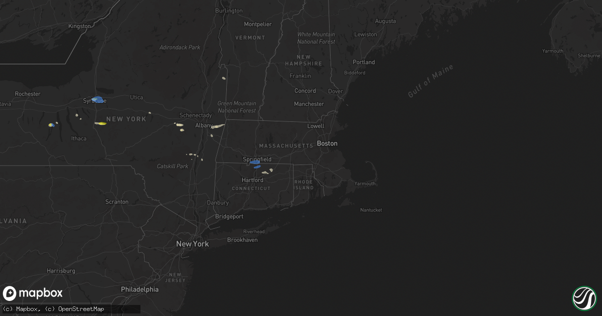
Hail Map in Massachusetts on June 29, 2021
Get this storm
June 29 map
$229
one time, instant access
Download today. No call, no setup
Keep the $229
Bought the map and want the full workflow? Apply the entire $229 to a subscription within 7 days. None of it is wasted.
Every map, not just this one
This buys you this map. Subscription and you get every map we run, in the markets you choose from a few cities to whole states to nationwide. Plus real-time alerts the moment a storm fires.
Contact data
Name, contact info, occupancy, even credit band for addresses in the footprint. You go from where it hit to who to call.
Become the source they trust
Unlimited branding weather history reports on demand. You already have the documented answer ready for the property owner, and you are the one who showed up with it.
Property data and RoofTrace estimates
Pull up any address you have got, its value and the exact code rules for that jurisdiction, straight from One Click Code. Then RoofTrace estimates the squares, pitch, and roof value, priced the way you price.
Storm reports in Massachusetts
Massachusetts
| Date | Description |
|---|---|
| 06/29/20216:55 PM CDT | Tree fallen on west road near reservoir road |
| 06/29/20216:32 PM CDT | Several large trees down maple street |
| 06/29/20216:23 PM CDT | Tree and wires down on river road and tree down on main street |
| 06/29/20216:18 PM CDT | Trees and wires down on main street |
| 06/29/20216:08 PM CDT | One foot diameter tree down across rising corner road at the agawam town line |
| 06/29/20215:49 PM CDT | Tree down on berkshire ave |
| 06/29/20215:44 PM CDT | Tree down on sheep pasture road |
| 06/29/20215:42 PM CDT | Tree down on sheep pasture road |
| 06/29/20215:40 PM CDT | Large tree and wires down on long yard road |
| 06/29/20215:26 PM CDT | Tree and wires down on house basket street |
| 06/29/20215:25 PM CDT | Wires down making lake parkway impassable |
| 06/29/20215:05 PM CDT | Trees down. |
| 06/29/20214:45 PM CDT | Trees down. |
| 06/29/20214:40 PM CDT | Trees down. |
| 06/29/20214:20 PM CDT | Tree down on prince street at pond street |
| 06/29/20214:20 PM CDT | Wires down on wolcott road |
| 06/29/20216:05 AM CDT | At 1104 PM EDT, a severe thunderstorm was located near Catskill, moving east at 15 mph. HAZARD...60 mph wind gusts. SOURCE...Radar indicated. IMPACT...Expect damage to roofs, siding, and trees. Locations impacted include... Hudson, Catskill, Saugerties, Claverack, Livingston, Copake, Clermont, Athens, Austerlitz, Philmont, Lorenz Park, Claverack-Red Mills, Saugerties South, Ghent, Veteran, Germantown, Hillsdale, Taghkanic, Centerville and Quarryville. |
| 06/29/20212:45 AM CDT | At 745 PM EDT, severe thunderstorms were located along a line extending from East Greenbush to near New Baltimore to 7 miles east of Preston Hollow, moving east at 15 mph. HAZARD...60 mph wind gusts and penny size hail. SOURCE...Radar indicated. IMPACT...Expect damage to roofs, siding, and trees. Locations impacted include... East Greenbush, Rensselaer, Chatham, Nassau, Delmar, New Baltimore, Ravena, Stephentown, Coxsackie, New Lebanon, Valatie, Castleton-On-Hudson, Kinderhook, Selkirk, Feura Bush, Coeymans, Cairo, Ghent, Stockport and Stuyvesant. |
| 06/29/20212:34 AM CDT | At 734 PM EDT, severe thunderstorms were located along a line extending from near Longmeadow to near Rocky Hill, moving southeast at 20 mph. HAZARD...60 mph wind gusts. SOURCE...Radar indicated. IMPACT...Expect damage to trees and power lines. Locations impacted include... Springfield, Hartford, Manchester, East Hartford, Enfield, Glastonbury, Vernon, Windsor, Agawam, West Springfield, Wethersfield, Mansfield, South Windsor, Windham, Rocky Hill, Willimantic, Southbridge, Longmeadow, Suffield and East Longmeadow. |
| 06/29/20211:59 AM CDT | At 658 PM EDT, severe thunderstorms were clustered over Southwick, or near Westfield, moving east at 15 mph. HAZARD...60 mph wind gusts and penny size hail. SOURCE...Radar indicated. IMPACT...Expect damage to trees and power lines. Locations impacted include... Springfield, Chicopee, Enfield, Westfield, Holyoke, Agawam, West Springfield, Ludlow, Longmeadow, Suffield, East Longmeadow, Ellington, Tolland, Belchertown, Wilbraham, Windsor Locks, Palmer, Stafford, Somers and Granby. |
| 06/29/202112:15 AM CDT | At 515 PM EDT, severe thunderstorms were located along a line extending from Williamstown to near Pittsfield to Chatham, moving east at 25 mph. HAZARD...60 mph wind gusts and penny size hail. SOURCE...Radar indicated. IMPACT...Expect damage to roofs, siding, and trees. Locations impacted include... Pittsfield, North Adams, Chatham, Adams, Williamstown, Lee, Lenox, Cheshire, New Lebanon, Becket, Austerlitz, Florida, Hancock, Savoy, New Ashford, Berkshire, Dalton, Ghent, Lanesborough and Hinsdale. |
| 06/28/202111:42 PM CDT | At 442 PM EDT, a severe thunderstorm was located near Stephentown, or near Nassau, moving southeast at 15 mph. HAZARD...60 mph wind gusts and penny size hail. SOURCE...Radar indicated. IMPACT...Expect damage to roofs, siding, and trees. Locations impacted include... Pittsfield, Nassau, Lenox, Cheshire, Stephentown, New Lebanon, Hancock, West Sand Lake, Averill Park, Berkshire, Sand Lake, Lanesborough, Canaan, Richmond, West Stockbridge, East Nassau, Barkerville, Van Hoesen Station, West Stephentown and Jacks Corners. |
All States Impacted by Hail Map on June 29, 2021
Cities Impacted by Hail Map on June 29, 2021
- Perrysville, OH
- Loudonville, OH
- Horseshoe Bend, ID
- Coldwater, MI
- Bronson, MI
- Overton, NV
- Logandale, NV
- Granville, NY
- Colorado City, AZ
- Auburn, KY
- Sycamore, OH
- Williamston, MI
- Webberville, MI
- Collins, NY
- Springville, NY
- Vanlue, OH
- Findlay, OH
- Etna, NH
- Hanover, NH
- Evanston, IN
- Grandview, IN
- Troy, IN
- Lewisport, KY
- Hawesville, KY
- Tell City, IN
- Scipio Center, NY
- Auburn, NY
- Moravia, NY
- New Carlisle, IN
- South Bend, IN
- Adairville, KY
- Coudersport, PA
- Port Allegany, PA
- Roulette, PA
- Austin, PA
- Fair Oaks, IN
- Morocco, IN
- Rensselaer, IN
- Lake Village, IN
- Livermore, KY
- Dayton, OH
- Versailles, IN
- Holton, IN
- Osgood, IN
- Syracuse, NY
- Connersville, IN
- Potomac, IL
- Watson, IL
- Germantown, NY
- Xenia, IL
- Fayetteville, TN
- Allons, TN
- Monroe, TN
- Livingston, TN
- Celina, TN
- Burkesville, KY
- Palm Harbor, FL
- Tarpon Springs, FL
- Greensburg, IN
- Manchester, MI
- Sparta, TN
- Upper Sandusky, OH
- Louisville, IL
- Edgewood, IL
- Mason, IL
- Farina, IL
- Truxton, NY
- Cincinnatus, NY
- Saugerties, NY
- Seymour, IN
- Saint Elmo, IL
- Schoharie, NY
- Berne, NY
- Wharton, OH
- Forest, OH
- Nevada, OH
- Bucyrus, OH
- Bethpage, TN
- Portland, TN
- Centerville, TN
- Duck River, TN
- Hampshire, TN
- Ann Arbor, MI
- Saline, MI
- Leavenworth, IN
- Wilmington, OH
- Washington Court House, OH
- Sabina, OH
- Sells, AZ
- Painesville, OH
- Mayo, FL
- Penn Yan, NY
- Rockville, IN
- Bristow, IN
- Birdseye, IN
- Urbana, OH
- Hopkinsville, KY
- Richfield Springs, NY
- Hubbard, OH
- Vienna, OH
- Girard, OH
- West Salem, OH
- Niles, OH
- Mount Blanchard, OH
- Ferdinand, IN
- Saint Meinrad, IN
- Middleburgh, NY
- Elyria, OH
- Oberlin, OH
- Lagrange, OH
- Jacksonville, IL
- Cromwell, KY
- Beaver Dam, KY
- Ashland City, TN
- Cunningham, KY
- Bardwell, KY
- Avon Lake, OH
- Avon, OH
- Gaston, IN
- Muncie, IN
- Laurel, IN
- Homerville, OH
- Sullivan, OH
- Spencer, OH
- Old Town, FL
- Watertown, TN
- Lebanon, TN
- Panama City, FL
- Freeport, FL
- Ebro, FL
- Ponce De Leon, FL
- Effingham, IL
- Dieterich, IL
- French Lick, IN
- Malden Bridge, NY
- Brainard, NY
- Nassau, NY
- Old Chatham, NY
- Kane, PA
- Sheffield, PA
- Huntington, IN
- Urbana, IN
- North Manchester, IN
- Fancy Farm, KY
- Keuka Park, NY
- Freetown, IN
- Huntingdon, TN
- Greenville, PA
- Dexter, MI
- Oakland City, IN
- Russellville, KY
- Creston, OH
- Burbank, OH
- Roachdale, IN
- Russellville, IN
- Charlotte, TN
- Dickson, TN
- Monroe, OH
- Lebanon, OH
- De Ruyter, NY
- Cortland, NY
- Homer, NY
- McGraw, NY
- Lagrange, IN
- Angola, IN
- Hudson, IN
- Celestine, IN
- Eckerty, IN
- Bradley, IL
- Bourbonnais, IL
- Kankakee, IL
- Big Sandy, TN
- Clinton, MI
- Tecumseh, MI
- Delaware, OH
- Etowah, TN
- Paoli, IN
- Hardinsburg, IN
- Iona, ID
- Wickliffe, KY
- Kevil, KY
- Elkton, KY
- Rootstown, OH
- Grass Lake, MI
- Munith, MI
- Jackson, MI
- Wawaka, IN
- Kimmell, IN
- Rome City, IN
- Kendallville, IN
- Albion, IN
- Ligonier, IN
- Englewood, TN
- Athens, TN
- Martinton, IL
- Clifton, IL
- Howe, IN
- Lobelville, TN
- Linden, TN
- Swartz Creek, MI
- Gaines, MI
- Fenton, MI
- Grand Blanc, MI
- Fort Wayne, IN
- Columbus, IN
- Utica, KY
- Cincinnati, OH
- Loveland, OH
- Iuka, IL
- Dillsboro, IN
- Waverly, TN
- Lutts, TN
- Collinwood, TN
- Warren, OH
- Taswell, IN
- Herndon, KY
- Oak Grove, KY
- Troy, PA
- Mainesburg, PA
- Delphi, IN
- Liberty, IN
- Cobleskill, NY
- Howes Cave, NY
- Mason, WI
- Caneyville, KY
- Hartford, KY
- Palenville, NY
- Hartville, OH
- Alliance, OH
- Louisville, OH
- Rumsey, KY
- Calhoun, KY
- Arlington, OH
- Lodi, OH
- Medina, OH
- Seville, OH
- Maineville, OH
- Mason, OH
- Laotto, IN
- Cadiz, KY
- Hermitage, PA
- Sharpsville, PA
- Erin, TN
- Tennessee Ridge, TN
- Beaverville, IL
- Flora, IL
- English, IN
- Akron, IN
- Danville, OH
- Springville, TN
- Heyworth, IL
- Bloomington, IL
- Sand Lake, NY
- Averill Park, NY
- Holland, NY
- Bowling Green, KY
- Moores Hill, IN
- Aurora, IN
- Greenville, IN
- Lamar, IN
- Philpot, KY
- Whitesville, KY
- Centertown, KY
- Branchville, IN
- Saint Croix, IN
- Perry, MI
- Elka Park, NY
- Cable, OH
- Woodstock, OH
- Stewart, TN
- Owensboro, KY
- Wheatfield, IN
- Paris, IL
- Mattoon, IL
- Griggsville, IL
- Sugar Tree, TN
- Stafford Springs, CT
- Willington, CT
- Plymouth, IN
- Bremen, IN
- McEwen, TN
- Norwich, VT
- Tippecanoe, IN
- Argos, IN
- New Berlin, IL
- Ramsey, IN
- Depauw, IN
- South Lyon, MI
- West Pawlet, VT
- Dresden, NY
- Springfield, OH
- Ten Mile, TN
- Elizaville, NY
- Leopold, IN
- Cannelton, IN
- Columbia City, IN
- Niota, TN
- North Ridgeville, OH
- Syracuse, IN
- Leesburg, IN
- Warsaw, IN
- Catskill, NY
- Taylor, MI
- Chenoa, IL
- Mitchell, IN
- Deputy, IN
- Commiskey, IN
- Miamisburg, OH
- Fairbanks, IN
- Oldsmar, FL
- Safety Harbor, FL
- Elizabethtown, IN
- Scipio, IN
- Medora, IN
- Brownstown, IN
- Belfast, TN
- Petersburg, TN
- Ellington, CT
- Tolland, CT
- Vernon Rockville, CT
- Louisville, KY
- Pembroke, KY
- Orleans, IN
- Santa Claus, IN
- Greenville, FL
- Westport, IN
- Earl Park, IN
- Fowler, IN
- South Wales, NY
- Boston, NY
- East Concord, NY
- Glenwood, NY
- Sweetwater, TN
- Churubusco, IN
- Huntertown, IN
- Auburn, IN
- Garrett, IN
- Browder, KY
- Greenville, KY
- Drakesboro, KY
- Beechmont, KY
- Beech Creek, KY
- Belton, KY
- Demotte, IN
- Island, KY
- Paducah, KY
- Scottsburg, IN
- North Vernon, IN
- Whitmore Lake, MI
- Rockfield, KY
- Garden Valley, ID
- Bowling Green, OH
- Kouts, IN
- Crestview, FL
- Wabash, IN
- Saint Clair Shores, MI
- Madisonville, TN
- Fairborn, OH
- Medway, OH
- Rossville, IL
- Marengo, IN
- Vanleer, TN
- Adams, TN
- Cedar Hill, TN
- Wellington, OH
- South Whitley, IN
- Rushville, IN
- Salem, IL
- Johnsonville, IL
- Roseville, MI
- Galeton, PA
- Berlin, NY
- Petersburg, NY
- Bloomville, OH
- Clifton, TN
- Downs, IL
- Shirley, IL
- Smithville, TN
- Manlius, NY
- Jamesville, NY
- East Syracuse, NY
- Minoa, NY
- Kirkville, NY
- Fayetteville, NY
- Liverpool, NY
- Caliente, NV
- Brook, IN
- Kentland, IN
- Corunna, IN
- Waterloo, IN
- Ashley, IN
- New Carlisle, OH
- Enon, OH
- Xenia, OH
- Donnelsville, OH
- Yellow Springs, OH
- Alpha, OH
- Suffield, CT
- Enfield, CT
- Springfield, MA
- Southwick, MA
- West Suffield, CT
- Longmeadow, MA
- East Longmeadow, MA
- Feeding Hills, MA
- Agawam, MA
- Goodrich, MI
- Atlas, MI
- Flint, MI
- Burton, MI
- Davison, MI
- Canaan, NH


