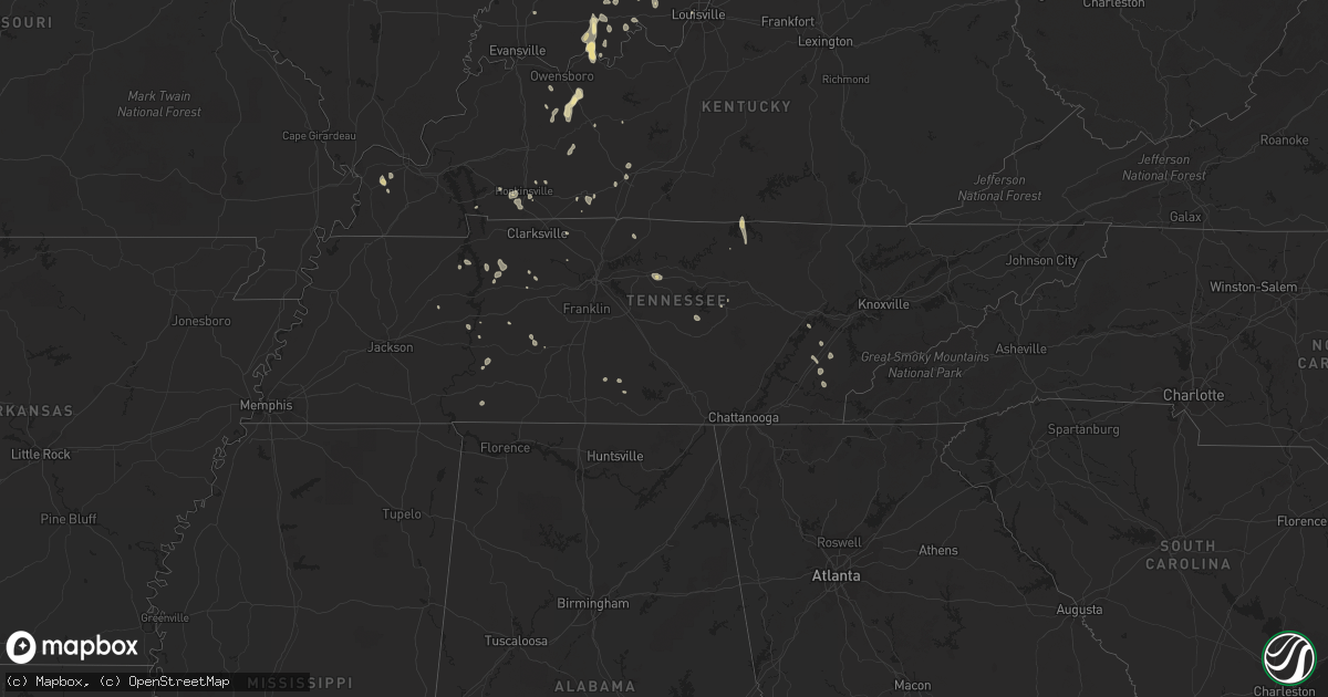
Hail Map in Tennessee on June 29, 2021
Get this storm
June 29 map
$229
one time, instant access
Download today. No call, no setup
Keep the $229
Bought the map and want the full workflow? Apply the entire $229 to a subscription within 7 days. None of it is wasted.
Every map, not just this one
This buys you this map. Subscription and you get every map we run, in the markets you choose from a few cities to whole states to nationwide. Plus real-time alerts the moment a storm fires.
Contact data
Name, contact info, occupancy, even credit band for addresses in the footprint. You go from where it hit to who to call.
Become the source they trust
Unlimited branding weather history reports on demand. You already have the documented answer ready for the property owner, and you are the one who showed up with it.
Property data and RoofTrace estimates
Pull up any address you have got, its value and the exact code rules for that jurisdiction, straight from One Click Code. Then RoofTrace estimates the squares, pitch, and roof value, priced the way you price.
Storm reports in Tennessee
Tennessee
| Date | Description |
|---|---|
| 06/29/20213:50 PM CDT | Multiple trees down along i75 northbound at mm57. |
| 06/29/20213:10 PM CDT | Downed tree blocking both lanes of bobbitt road. |
| 06/29/20213:00 PM CDT | Numerous trees down and over roads across southern benton couny especially around the community of holladay. |
| 06/29/20212:30 PM CDT | A couple trees down in the dickson and burns area |
| 06/29/202112:20 PM CDT | Tree down on swann creek road |
| 06/29/20217:47 AM CDT | At 1247 PM CDT, a severe thunderstorm was located 8 miles southeast of Olive Hill, or 13 miles southwest of Waynesboro, moving west at 15 mph. HAZARD...Quarter size hail. SOURCE...Radar indicated. IMPACT...Damage to vehicles is expected. Locations impacted include... Lutts. |
| 06/28/202111:20 PM CDT | At 420 PM EDT, a severe thunderstorm was located over Etowah, or near Athens, moving northwest at 15 mph. HAZARD...60 mph wind gusts and penny size hail. SOURCE...Radar indicated. IMPACT...Expect damage to roofs, siding, and trees. Locations impacted include... Athens, Etowah, Englewood, Niota, Riceville, Clear Water, Hillsview and Dentville.This includes Interstate 75 in Tennessee between mile markers 39 and60. |
| 06/28/20219:58 PM CDT | At 258 PM CDT, a severe thunderstorm was located over Watertown, or 12 miles southwest of Carthage, moving west at 20 mph. HAZARD...60 mph wind gusts and quarter size hail. SOURCE...Radar indicated. IMPACT...Hail damage to vehicles is expected. Expect wind damage to roofs, siding, and trees. Locations impacted include... Lebanon, Watertown, Alexandria and Tuckers Crossroads. This includes Interstate 40 between mile markers 236 and 254. |
| 06/28/20219:50 PM CDT | At 250 PM CDT, a severe thunderstorm was located near Natchez Trace State Park, moving west at 10 mph. HAZARD...60 mph wind gusts. SOURCE...Radar indicated. IMPACT...Expect damage to roofs, siding, and trees. Locations impacted include... Lexington, Huntingdon, Natchez Trace State Park, Natchez Trace State Forest, Parsons, Bruceton, Parkers Crossroads, Bargerton, Wildersville, Hollow Rock, Clarksburg, Hillard, Dollar, Jeannette, Union Cross, Holladay, Leach, Timberlake, Tate and Palmer Shelter. |
| 06/28/20218:12 PM CDT | At 112 PM CDT, a severe thunderstorm was located 9 miles south of Centerville, moving west at 15 mph. HAZARD...60 mph wind gusts and quarter size hail. SOURCE...Radar indicated. IMPACT...Hail damage to vehicles is expected. Expect wind damage to roofs, siding, and trees. Locations impacted include... Centerville, Gordonsburg and Kimmins. |
All States Impacted by Hail Map on June 29, 2021
Cities Impacted by Hail Map on June 29, 2021
- Perrysville, OH
- Loudonville, OH
- Horseshoe Bend, ID
- Coldwater, MI
- Bronson, MI
- Overton, NV
- Logandale, NV
- Granville, NY
- Colorado City, AZ
- Auburn, KY
- Sycamore, OH
- Williamston, MI
- Webberville, MI
- Collins, NY
- Springville, NY
- Vanlue, OH
- Findlay, OH
- Etna, NH
- Hanover, NH
- Evanston, IN
- Grandview, IN
- Troy, IN
- Lewisport, KY
- Hawesville, KY
- Tell City, IN
- Scipio Center, NY
- Auburn, NY
- Moravia, NY
- New Carlisle, IN
- South Bend, IN
- Adairville, KY
- Coudersport, PA
- Port Allegany, PA
- Roulette, PA
- Austin, PA
- Fair Oaks, IN
- Morocco, IN
- Rensselaer, IN
- Lake Village, IN
- Livermore, KY
- Dayton, OH
- Versailles, IN
- Holton, IN
- Osgood, IN
- Syracuse, NY
- Connersville, IN
- Potomac, IL
- Watson, IL
- Germantown, NY
- Xenia, IL
- Fayetteville, TN
- Allons, TN
- Monroe, TN
- Livingston, TN
- Celina, TN
- Burkesville, KY
- Palm Harbor, FL
- Tarpon Springs, FL
- Greensburg, IN
- Manchester, MI
- Sparta, TN
- Upper Sandusky, OH
- Louisville, IL
- Edgewood, IL
- Mason, IL
- Farina, IL
- Truxton, NY
- Cincinnatus, NY
- Saugerties, NY
- Seymour, IN
- Saint Elmo, IL
- Schoharie, NY
- Berne, NY
- Wharton, OH
- Forest, OH
- Nevada, OH
- Bucyrus, OH
- Bethpage, TN
- Portland, TN
- Centerville, TN
- Duck River, TN
- Hampshire, TN
- Ann Arbor, MI
- Saline, MI
- Leavenworth, IN
- Wilmington, OH
- Washington Court House, OH
- Sabina, OH
- Sells, AZ
- Painesville, OH
- Mayo, FL
- Penn Yan, NY
- Rockville, IN
- Bristow, IN
- Birdseye, IN
- Urbana, OH
- Hopkinsville, KY
- Richfield Springs, NY
- Hubbard, OH
- Vienna, OH
- Girard, OH
- West Salem, OH
- Niles, OH
- Mount Blanchard, OH
- Ferdinand, IN
- Saint Meinrad, IN
- Middleburgh, NY
- Elyria, OH
- Oberlin, OH
- Lagrange, OH
- Jacksonville, IL
- Cromwell, KY
- Beaver Dam, KY
- Ashland City, TN
- Cunningham, KY
- Bardwell, KY
- Avon Lake, OH
- Avon, OH
- Gaston, IN
- Muncie, IN
- Laurel, IN
- Homerville, OH
- Sullivan, OH
- Spencer, OH
- Old Town, FL
- Watertown, TN
- Lebanon, TN
- Panama City, FL
- Freeport, FL
- Ebro, FL
- Ponce De Leon, FL
- Effingham, IL
- Dieterich, IL
- French Lick, IN
- Malden Bridge, NY
- Brainard, NY
- Nassau, NY
- Old Chatham, NY
- Kane, PA
- Sheffield, PA
- Huntington, IN
- Urbana, IN
- North Manchester, IN
- Fancy Farm, KY
- Keuka Park, NY
- Freetown, IN
- Huntingdon, TN
- Greenville, PA
- Dexter, MI
- Oakland City, IN
- Russellville, KY
- Creston, OH
- Burbank, OH
- Roachdale, IN
- Russellville, IN
- Charlotte, TN
- Dickson, TN
- Monroe, OH
- Lebanon, OH
- De Ruyter, NY
- Cortland, NY
- Homer, NY
- McGraw, NY
- Lagrange, IN
- Angola, IN
- Hudson, IN
- Celestine, IN
- Eckerty, IN
- Bradley, IL
- Bourbonnais, IL
- Kankakee, IL
- Big Sandy, TN
- Clinton, MI
- Tecumseh, MI
- Delaware, OH
- Etowah, TN
- Paoli, IN
- Hardinsburg, IN
- Iona, ID
- Wickliffe, KY
- Kevil, KY
- Elkton, KY
- Rootstown, OH
- Grass Lake, MI
- Munith, MI
- Jackson, MI
- Wawaka, IN
- Kimmell, IN
- Rome City, IN
- Kendallville, IN
- Albion, IN
- Ligonier, IN
- Englewood, TN
- Athens, TN
- Martinton, IL
- Clifton, IL
- Howe, IN
- Lobelville, TN
- Linden, TN
- Swartz Creek, MI
- Gaines, MI
- Fenton, MI
- Grand Blanc, MI
- Fort Wayne, IN
- Columbus, IN
- Utica, KY
- Cincinnati, OH
- Loveland, OH
- Iuka, IL
- Dillsboro, IN
- Waverly, TN
- Lutts, TN
- Collinwood, TN
- Warren, OH
- Taswell, IN
- Herndon, KY
- Oak Grove, KY
- Troy, PA
- Mainesburg, PA
- Delphi, IN
- Liberty, IN
- Cobleskill, NY
- Howes Cave, NY
- Mason, WI
- Caneyville, KY
- Hartford, KY
- Palenville, NY
- Hartville, OH
- Alliance, OH
- Louisville, OH
- Rumsey, KY
- Calhoun, KY
- Arlington, OH
- Lodi, OH
- Medina, OH
- Seville, OH
- Maineville, OH
- Mason, OH
- Laotto, IN
- Cadiz, KY
- Hermitage, PA
- Sharpsville, PA
- Erin, TN
- Tennessee Ridge, TN
- Beaverville, IL
- Flora, IL
- English, IN
- Akron, IN
- Danville, OH
- Springville, TN
- Heyworth, IL
- Bloomington, IL
- Sand Lake, NY
- Averill Park, NY
- Holland, NY
- Bowling Green, KY
- Moores Hill, IN
- Aurora, IN
- Greenville, IN
- Lamar, IN
- Philpot, KY
- Whitesville, KY
- Centertown, KY
- Branchville, IN
- Saint Croix, IN
- Perry, MI
- Elka Park, NY
- Cable, OH
- Woodstock, OH
- Stewart, TN
- Owensboro, KY
- Wheatfield, IN
- Paris, IL
- Mattoon, IL
- Griggsville, IL
- Sugar Tree, TN
- Stafford Springs, CT
- Willington, CT
- Plymouth, IN
- Bremen, IN
- McEwen, TN
- Norwich, VT
- Tippecanoe, IN
- Argos, IN
- New Berlin, IL
- Ramsey, IN
- Depauw, IN
- South Lyon, MI
- West Pawlet, VT
- Dresden, NY
- Springfield, OH
- Ten Mile, TN
- Elizaville, NY
- Leopold, IN
- Cannelton, IN
- Columbia City, IN
- Niota, TN
- North Ridgeville, OH
- Syracuse, IN
- Leesburg, IN
- Warsaw, IN
- Catskill, NY
- Taylor, MI
- Chenoa, IL
- Mitchell, IN
- Deputy, IN
- Commiskey, IN
- Miamisburg, OH
- Fairbanks, IN
- Oldsmar, FL
- Safety Harbor, FL
- Elizabethtown, IN
- Scipio, IN
- Medora, IN
- Brownstown, IN
- Belfast, TN
- Petersburg, TN
- Ellington, CT
- Tolland, CT
- Vernon Rockville, CT
- Louisville, KY
- Pembroke, KY
- Orleans, IN
- Santa Claus, IN
- Greenville, FL
- Westport, IN
- Earl Park, IN
- Fowler, IN
- South Wales, NY
- Boston, NY
- East Concord, NY
- Glenwood, NY
- Sweetwater, TN
- Churubusco, IN
- Huntertown, IN
- Auburn, IN
- Garrett, IN
- Browder, KY
- Greenville, KY
- Drakesboro, KY
- Beechmont, KY
- Beech Creek, KY
- Belton, KY
- Demotte, IN
- Island, KY
- Paducah, KY
- Scottsburg, IN
- North Vernon, IN
- Whitmore Lake, MI
- Rockfield, KY
- Garden Valley, ID
- Bowling Green, OH
- Kouts, IN
- Crestview, FL
- Wabash, IN
- Saint Clair Shores, MI
- Madisonville, TN
- Fairborn, OH
- Medway, OH
- Rossville, IL
- Marengo, IN
- Vanleer, TN
- Adams, TN
- Cedar Hill, TN
- Wellington, OH
- South Whitley, IN
- Rushville, IN
- Salem, IL
- Johnsonville, IL
- Roseville, MI
- Galeton, PA
- Berlin, NY
- Petersburg, NY
- Bloomville, OH
- Clifton, TN
- Downs, IL
- Shirley, IL
- Smithville, TN
- Manlius, NY
- Jamesville, NY
- East Syracuse, NY
- Minoa, NY
- Kirkville, NY
- Fayetteville, NY
- Liverpool, NY
- Caliente, NV
- Brook, IN
- Kentland, IN
- Corunna, IN
- Waterloo, IN
- Ashley, IN
- New Carlisle, OH
- Enon, OH
- Xenia, OH
- Donnelsville, OH
- Yellow Springs, OH
- Alpha, OH
- Suffield, CT
- Enfield, CT
- Springfield, MA
- Southwick, MA
- West Suffield, CT
- Longmeadow, MA
- East Longmeadow, MA
- Feeding Hills, MA
- Agawam, MA
- Goodrich, MI
- Atlas, MI
- Flint, MI
- Burton, MI
- Davison, MI
- Canaan, NH


