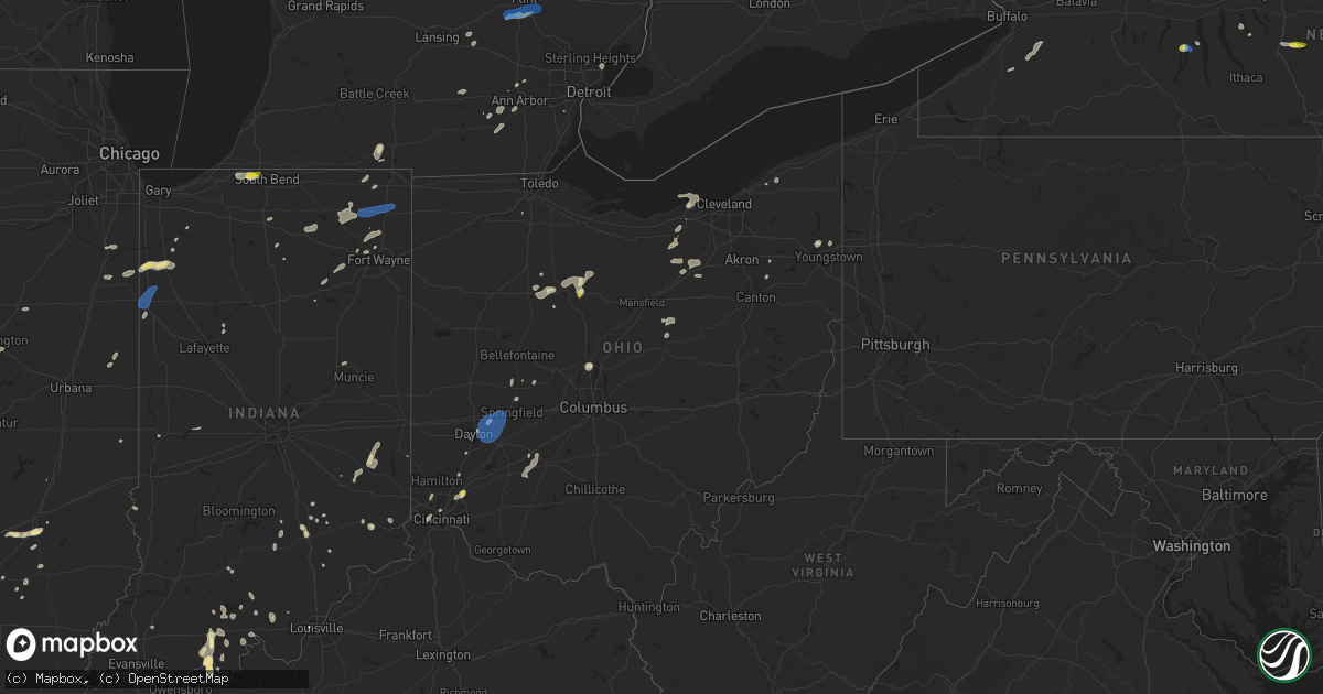
Hail Map in Ohio on June 29, 2021
Get this storm
June 29 map
$229
one time, instant access
Download today. No call, no setup
Keep the $229
Bought the map and want the full workflow? Apply the entire $229 to a subscription within 7 days. None of it is wasted.
Every map, not just this one
This buys you this map. Subscription and you get every map we run, in the markets you choose from a few cities to whole states to nationwide. Plus real-time alerts the moment a storm fires.
Contact data
Name, contact info, occupancy, even credit band for addresses in the footprint. You go from where it hit to who to call.
Become the source they trust
Unlimited branding weather history reports on demand. You already have the documented answer ready for the property owner, and you are the one who showed up with it.
Property data and RoofTrace estimates
Pull up any address you have got, its value and the exact code rules for that jurisdiction, straight from One Click Code. Then RoofTrace estimates the squares, pitch, and roof value, priced the way you price.
Storm reports in Ohio
Ohio
| Date | Description |
|---|---|
| 06/29/20216:59 PM CDT | Large tree down on e birch rd. Time est from radar. |
| 06/29/20216:35 PM CDT | One tree downed on old 3c hwy. Time of event estimated from radar. |
| 06/29/20216:33 PM CDT | Several trees and powerlines down around king graves rd. |
| 06/29/20216:33 PM CDT | Large tree uprooted and fell on home along youngstown-kingsville road near cadwallader-sonk road. |
| 06/29/20216:19 PM CDT | Time est by radar. |
| 06/29/20215:55 PM CDT | Large tree branches down in yard. |
| 06/29/20215:43 PM CDT | Tree down on a camper at west branch state park campground. |
| 06/29/20215:34 PM CDT | Tree down on julmar dr. Time est from radar. |
| 06/29/20215:20 PM CDT | Small to medium tree down on house. Time estimated based on radar. |
| 06/29/20214:44 PM CDT | Several large tree limbs down across rt 604. Water also ponding on road 1 inch deep. |
| 06/29/20214:44 PM CDT | Tree down across cr 75. |
| 06/29/20214:35 PM CDT | Tree down across tr 451. |
| 06/29/20214:30 PM CDT | Pine tree down on guilford rd. |
| 06/29/20214:24 PM CDT | Tree fell bringing down power lines and poles. |
| 06/29/20214:15 PM CDT | Several tress and tree limbs down at chippewa lake. |
| 06/29/20214:15 PM CDT | Tree limbs down along with an apple tree split at the base. Half inch size hail also reported. |
| 06/29/20214:08 PM CDT | Tree down on main st between oak st and cherry st. |
| 06/29/20213:32 PM CDT | Tree down on road. |
| 06/29/20213:30 PM CDT | A local report indicates 59 MPH wind near KFFO WRIGHT-PATT AFB |
| 06/29/20212:48 PM CDT | Tree uprooted along marion melmore rd near lemert. |
| 06/29/20211:17 PM CDT | Tree uprooted in concord township... Painesville... Oh. |
| 06/29/20211:11 PM CDT | Tree uprooted along leroy center rd in leroy township... Painesville... Oh. |
| 06/29/20212:45 AM CDT | At 745 PM EDT, a severe thunderstorm was located near Versailles, moving northeast at 10 mph. HAZARD...60 mph wind gusts and quarter size hail. SOURCE...Radar indicated. IMPACT...Minor hail damage to vehicles is possible. Expect wind damage to trees and power lines. Locations impacted include... Lawrenceburg, Greendale, Aurora, Bright, Hidden Valley, Versailles, Milan, Osgood, Dillsboro, Moores Hill, Guilford, Wilmington, Manchester, Sunman, Rexville, Cold Springs, Farmers Retreat, Friendship, Versailles Lake and Mount Sinai. |
| 06/29/20212:08 AM CDT | At 708 PM EDT, a severe thunderstorm was located over Sixteen Mile Stand, moving northeast at 25 mph. HAZARD...60 mph wind gusts and penny size hail. SOURCE...Radar indicated. IMPACT...Expect damage to trees and power lines. Locations impacted include... Mason, Lebanon, Sharonville, Monroe, Blue Ash, Loveland, Springdale, Reading, Montgomery, Madeira, Deer Park, West Chester, Morrow, Highpoint, Remington, Concorde Hills, Kings Island, Sixteen Mile Stand, Olde West Chester and Four Bridges.This includes the following Interstates... I-71 in Ohio between mile markers 13 and 41. I-75 in Ohio between mile markers 15 and 25. |
| 06/29/20212:05 AM CDT | At 705 PM EDT, a severe thunderstorm was located near Sycamore, or 10 miles northwest of Bucyrus, moving east at 35 mph. HAZARD...60 mph wind gusts and quarter size hail. SOURCE...Radar indicated. IMPACT...Minor damage to vehicles is possible. Expect damage to trees and power lines. Locations impacted include... Bucyrus, Upper Sandusky, Shelby, Willard, Plymouth, New Washington, Bloomville, Sycamore, Chatfield, Attica, Benton, Nevada, North Fairfield, Republic, Tiro, Oceola, Sulpher Springs and Shenandoah. |
| 06/29/20211:36 AM CDT | At 635 PM EDT, a severe thunderstorm was located near Forest, or 7 miles west of Upper Sandusky, moving east at 10 mph. HAZARD...60 mph wind gusts and penny size hail. SOURCE...Radar indicated. IMPACT...Expect damage to trees and power lines. Locations impacted include... Upper Sandusky, Forest, Sycamore, Carey, Nevada, Wharton, Harpster and Kirby. |
| 06/29/202112:42 AM CDT | At 542 PM EDT, a severe thunderstorm was located over Wadsworth, or 9 miles southeast of Medina, moving east at 15 mph. HAZARD...60 mph wind gusts. SOURCE...Radar indicated. IMPACT...Expect damage to trees and power lines. Locations impacted include... Akron, Wooster, Cuyahoga Falls, Barberton, Green, Hudson, Wadsworth, Tallmadge, Orrville, Rittman, Mogadore, Doylestown, Creston, Stow, New Franklin, Norton, Fairlawn, Munroe Falls, Lakemore and Silver Lake. |
| 06/29/202112:24 AM CDT | At 524 PM EDT, a severe thunderstorm was located over Loudonville, or 15 miles west of Millersburg, moving east at 15 mph. HAZARD...60 mph wind gusts and quarter size hail. SOURCE...Radar indicated. IMPACT...Minor damage to vehicles is possible. Expect damage to trees and power lines. Locations impacted include... Wooster, Millersburg, Loudonville, Shreve, Holmesville, Glenmont, Nashville, Perrysville, Fredericksburg and Mohicanville. |
| 06/29/202112:12 AM CDT | At 511 PM EDT, a severe thunderstorm was located over North Lewisburg, moving northeast at 30 mph. Another severe thunderstorm was located over Powhattan. HAZARD...60 mph wind gusts and quarter size hail. SOURCE...Radar indicated. IMPACT...Minor hail damage to vehicles is possible. Expect wind damage to trees and power lines. Locations impacted include... Springfield, Marysville, Urbana, Mechanicsburg, North Lewisburg, Milford Center, Tremont City, Woodstock, Catawba, Mutual, Cable, Raymond, Broadway, Middleburg, Powhattan, Mingo, Pottersburg, Catawba Station and Kennard. |
| 06/29/202112:06 AM CDT | At 506 PM EDT, a severe thunderstorm was located near Lodi, or 9 miles west of Medina, moving northeast at 20 mph. HAZARD...60 mph wind gusts. SOURCE...Radar indicated. IMPACT...Expect damage to trees and power lines. Locations impacted include... Medina, Strongsville, Brunswick, North Royalton, Grafton, Lodi, Chippewa Lake, Hinckley, Penfield, Westfield Center, Spencer, Gloria Glens Park, Burbank, Chippewa-On-The-Lake, Valley City, Briarwood Beach and Eaton Estates. |
| 06/28/202111:30 PM CDT | At 430 PM EDT, a severe thunderstorm was located near Fairborn, moving northeast at 10 mph. HAZARD...60 mph wind gusts and quarter size hail. SOURCE...Radar indicated. IMPACT...Minor hail damage to vehicles is possible. Expect wind damage to trees and power lines. Locations impacted include... Fairborn, New Carlisle, Wright-Patterson Afb, Enon, North Hampton, Donnelsville, Green Meadows, Medway, Springfield Municipal Airport, Hustead, Holiday Valley, Snyderville, Crystal Lakes and Park Layne.This includes I-70 in Ohio between mile markers 42 and 52. |
| 06/28/202111:06 PM CDT | At 406 PM EDT, a severe thunderstorm was located near Delaware, moving northeast at 10 mph. HAZARD...60 mph wind gusts and penny size hail. SOURCE...Radar indicated. IMPACT...Expect damage to trees and power lines. Locations impacted include... Delaware, Ashley, Interstate 71 at US Route 36/State Route 37, Kilbourne, Leonardsburg and Olive Green.This includes I-71 in Ohio between mile markers 130 and 138. |
| 06/28/202110:58 PM CDT | At 358 PM EDT, a severe thunderstorm was located near Sycamore, or 8 miles northeast of Upper Sandusky, moving northeast at 10 mph. HAZARD...60 mph wind gusts and quarter size hail. SOURCE...Radar indicated. IMPACT...Minor damage to vehicles is possible. Expect damage to trees and power lines. Locations impacted include... New Washington, Bloomville, Sycamore, Chatfield, Attica, Benton, Nevada, Republic and Oceola. |
| 06/28/202110:55 PM CDT | At 355 PM EDT, a severe thunderstorm was located over Wellington, or 14 miles south of Elyria, moving northeast at 15 mph. HAZARD...60 mph wind gusts and quarter size hail. SOURCE...Radar indicated. IMPACT...Minor damage to vehicles is possible. Expect damage to trees and power lines. Locations impacted include... Elyria, Strongsville, North Ridgeville, Grafton, Wellington, Avon, Eaton, Oberlin, Lagrange, Penfield, Pittsfield, Valley City and Eaton Estates. |
| 06/28/202110:29 PM CDT | At 329 PM EDT, a severe thunderstorm was located near Bucyrus, moving northeast at 35 mph. HAZARD...60 mph wind gusts and quarter size hail. SOURCE...Radar indicated. IMPACT...Minor damage to vehicles is possible. Expect damage to trees and power lines. Locations impacted include... Bucyrus, Willard, Plymouth, New Washington, Bloomville, Chatfield, Attica, Benton, Nevada, Tiro, Oceola and Sulpher Springs. |
| 06/28/20218:46 PM CDT | At 146 PM EDT, a severe thunderstorm was located near Perry, or 7 miles east of Painesville, moving northeast at 15 mph. HAZARD...60 mph wind gusts and nickel size hail. SOURCE...Radar indicated. IMPACT...Expect damage to trees and power lines. Locations impacted include... Chardon, Geneva, Madison, Perry, Montville, Roaming Shores, Thompson and Rock Creek. |
All States Impacted by Hail Map on June 29, 2021
Cities Impacted by Hail Map on June 29, 2021
- Perrysville, OH
- Loudonville, OH
- Horseshoe Bend, ID
- Coldwater, MI
- Bronson, MI
- Overton, NV
- Logandale, NV
- Granville, NY
- Colorado City, AZ
- Auburn, KY
- Sycamore, OH
- Williamston, MI
- Webberville, MI
- Collins, NY
- Springville, NY
- Vanlue, OH
- Findlay, OH
- Etna, NH
- Hanover, NH
- Evanston, IN
- Grandview, IN
- Troy, IN
- Lewisport, KY
- Hawesville, KY
- Tell City, IN
- Scipio Center, NY
- Auburn, NY
- Moravia, NY
- New Carlisle, IN
- South Bend, IN
- Adairville, KY
- Coudersport, PA
- Port Allegany, PA
- Roulette, PA
- Austin, PA
- Fair Oaks, IN
- Morocco, IN
- Rensselaer, IN
- Lake Village, IN
- Livermore, KY
- Dayton, OH
- Versailles, IN
- Holton, IN
- Osgood, IN
- Syracuse, NY
- Connersville, IN
- Potomac, IL
- Watson, IL
- Germantown, NY
- Xenia, IL
- Fayetteville, TN
- Allons, TN
- Monroe, TN
- Livingston, TN
- Celina, TN
- Burkesville, KY
- Palm Harbor, FL
- Tarpon Springs, FL
- Greensburg, IN
- Manchester, MI
- Sparta, TN
- Upper Sandusky, OH
- Louisville, IL
- Edgewood, IL
- Mason, IL
- Farina, IL
- Truxton, NY
- Cincinnatus, NY
- Saugerties, NY
- Seymour, IN
- Saint Elmo, IL
- Schoharie, NY
- Berne, NY
- Wharton, OH
- Forest, OH
- Nevada, OH
- Bucyrus, OH
- Bethpage, TN
- Portland, TN
- Centerville, TN
- Duck River, TN
- Hampshire, TN
- Ann Arbor, MI
- Saline, MI
- Leavenworth, IN
- Wilmington, OH
- Washington Court House, OH
- Sabina, OH
- Sells, AZ
- Painesville, OH
- Mayo, FL
- Penn Yan, NY
- Rockville, IN
- Bristow, IN
- Birdseye, IN
- Urbana, OH
- Hopkinsville, KY
- Richfield Springs, NY
- Hubbard, OH
- Vienna, OH
- Girard, OH
- West Salem, OH
- Niles, OH
- Mount Blanchard, OH
- Ferdinand, IN
- Saint Meinrad, IN
- Middleburgh, NY
- Elyria, OH
- Oberlin, OH
- Lagrange, OH
- Jacksonville, IL
- Cromwell, KY
- Beaver Dam, KY
- Ashland City, TN
- Cunningham, KY
- Bardwell, KY
- Avon Lake, OH
- Avon, OH
- Gaston, IN
- Muncie, IN
- Laurel, IN
- Homerville, OH
- Sullivan, OH
- Spencer, OH
- Old Town, FL
- Watertown, TN
- Lebanon, TN
- Panama City, FL
- Freeport, FL
- Ebro, FL
- Ponce De Leon, FL
- Effingham, IL
- Dieterich, IL
- French Lick, IN
- Malden Bridge, NY
- Brainard, NY
- Nassau, NY
- Old Chatham, NY
- Kane, PA
- Sheffield, PA
- Huntington, IN
- Urbana, IN
- North Manchester, IN
- Fancy Farm, KY
- Keuka Park, NY
- Freetown, IN
- Huntingdon, TN
- Greenville, PA
- Dexter, MI
- Oakland City, IN
- Russellville, KY
- Creston, OH
- Burbank, OH
- Roachdale, IN
- Russellville, IN
- Charlotte, TN
- Dickson, TN
- Monroe, OH
- Lebanon, OH
- De Ruyter, NY
- Cortland, NY
- Homer, NY
- McGraw, NY
- Lagrange, IN
- Angola, IN
- Hudson, IN
- Celestine, IN
- Eckerty, IN
- Bradley, IL
- Bourbonnais, IL
- Kankakee, IL
- Big Sandy, TN
- Clinton, MI
- Tecumseh, MI
- Delaware, OH
- Etowah, TN
- Paoli, IN
- Hardinsburg, IN
- Iona, ID
- Wickliffe, KY
- Kevil, KY
- Elkton, KY
- Rootstown, OH
- Grass Lake, MI
- Munith, MI
- Jackson, MI
- Wawaka, IN
- Kimmell, IN
- Rome City, IN
- Kendallville, IN
- Albion, IN
- Ligonier, IN
- Englewood, TN
- Athens, TN
- Martinton, IL
- Clifton, IL
- Howe, IN
- Lobelville, TN
- Linden, TN
- Swartz Creek, MI
- Gaines, MI
- Fenton, MI
- Grand Blanc, MI
- Fort Wayne, IN
- Columbus, IN
- Utica, KY
- Cincinnati, OH
- Loveland, OH
- Iuka, IL
- Dillsboro, IN
- Waverly, TN
- Lutts, TN
- Collinwood, TN
- Warren, OH
- Taswell, IN
- Herndon, KY
- Oak Grove, KY
- Troy, PA
- Mainesburg, PA
- Delphi, IN
- Liberty, IN
- Cobleskill, NY
- Howes Cave, NY
- Mason, WI
- Caneyville, KY
- Hartford, KY
- Palenville, NY
- Hartville, OH
- Alliance, OH
- Louisville, OH
- Rumsey, KY
- Calhoun, KY
- Arlington, OH
- Lodi, OH
- Medina, OH
- Seville, OH
- Maineville, OH
- Mason, OH
- Laotto, IN
- Cadiz, KY
- Hermitage, PA
- Sharpsville, PA
- Erin, TN
- Tennessee Ridge, TN
- Beaverville, IL
- Flora, IL
- English, IN
- Akron, IN
- Danville, OH
- Springville, TN
- Heyworth, IL
- Bloomington, IL
- Sand Lake, NY
- Averill Park, NY
- Holland, NY
- Bowling Green, KY
- Moores Hill, IN
- Aurora, IN
- Greenville, IN
- Lamar, IN
- Philpot, KY
- Whitesville, KY
- Centertown, KY
- Branchville, IN
- Saint Croix, IN
- Perry, MI
- Elka Park, NY
- Cable, OH
- Woodstock, OH
- Stewart, TN
- Owensboro, KY
- Wheatfield, IN
- Paris, IL
- Mattoon, IL
- Griggsville, IL
- Sugar Tree, TN
- Stafford Springs, CT
- Willington, CT
- Plymouth, IN
- Bremen, IN
- McEwen, TN
- Norwich, VT
- Tippecanoe, IN
- Argos, IN
- New Berlin, IL
- Ramsey, IN
- Depauw, IN
- South Lyon, MI
- West Pawlet, VT
- Dresden, NY
- Springfield, OH
- Ten Mile, TN
- Elizaville, NY
- Leopold, IN
- Cannelton, IN
- Columbia City, IN
- Niota, TN
- North Ridgeville, OH
- Syracuse, IN
- Leesburg, IN
- Warsaw, IN
- Catskill, NY
- Taylor, MI
- Chenoa, IL
- Mitchell, IN
- Deputy, IN
- Commiskey, IN
- Miamisburg, OH
- Fairbanks, IN
- Oldsmar, FL
- Safety Harbor, FL
- Elizabethtown, IN
- Scipio, IN
- Medora, IN
- Brownstown, IN
- Belfast, TN
- Petersburg, TN
- Ellington, CT
- Tolland, CT
- Vernon Rockville, CT
- Louisville, KY
- Pembroke, KY
- Orleans, IN
- Santa Claus, IN
- Greenville, FL
- Westport, IN
- Earl Park, IN
- Fowler, IN
- South Wales, NY
- Boston, NY
- East Concord, NY
- Glenwood, NY
- Sweetwater, TN
- Churubusco, IN
- Huntertown, IN
- Auburn, IN
- Garrett, IN
- Browder, KY
- Greenville, KY
- Drakesboro, KY
- Beechmont, KY
- Beech Creek, KY
- Belton, KY
- Demotte, IN
- Island, KY
- Paducah, KY
- Scottsburg, IN
- North Vernon, IN
- Whitmore Lake, MI
- Rockfield, KY
- Garden Valley, ID
- Bowling Green, OH
- Kouts, IN
- Crestview, FL
- Wabash, IN
- Saint Clair Shores, MI
- Madisonville, TN
- Fairborn, OH
- Medway, OH
- Rossville, IL
- Marengo, IN
- Vanleer, TN
- Adams, TN
- Cedar Hill, TN
- Wellington, OH
- South Whitley, IN
- Rushville, IN
- Salem, IL
- Johnsonville, IL
- Roseville, MI
- Galeton, PA
- Berlin, NY
- Petersburg, NY
- Bloomville, OH
- Clifton, TN
- Downs, IL
- Shirley, IL
- Smithville, TN
- Manlius, NY
- Jamesville, NY
- East Syracuse, NY
- Minoa, NY
- Kirkville, NY
- Fayetteville, NY
- Liverpool, NY
- Caliente, NV
- Brook, IN
- Kentland, IN
- Corunna, IN
- Waterloo, IN
- Ashley, IN
- New Carlisle, OH
- Enon, OH
- Xenia, OH
- Donnelsville, OH
- Yellow Springs, OH
- Alpha, OH
- Suffield, CT
- Enfield, CT
- Springfield, MA
- Southwick, MA
- West Suffield, CT
- Longmeadow, MA
- East Longmeadow, MA
- Feeding Hills, MA
- Agawam, MA
- Goodrich, MI
- Atlas, MI
- Flint, MI
- Burton, MI
- Davison, MI
- Canaan, NH


