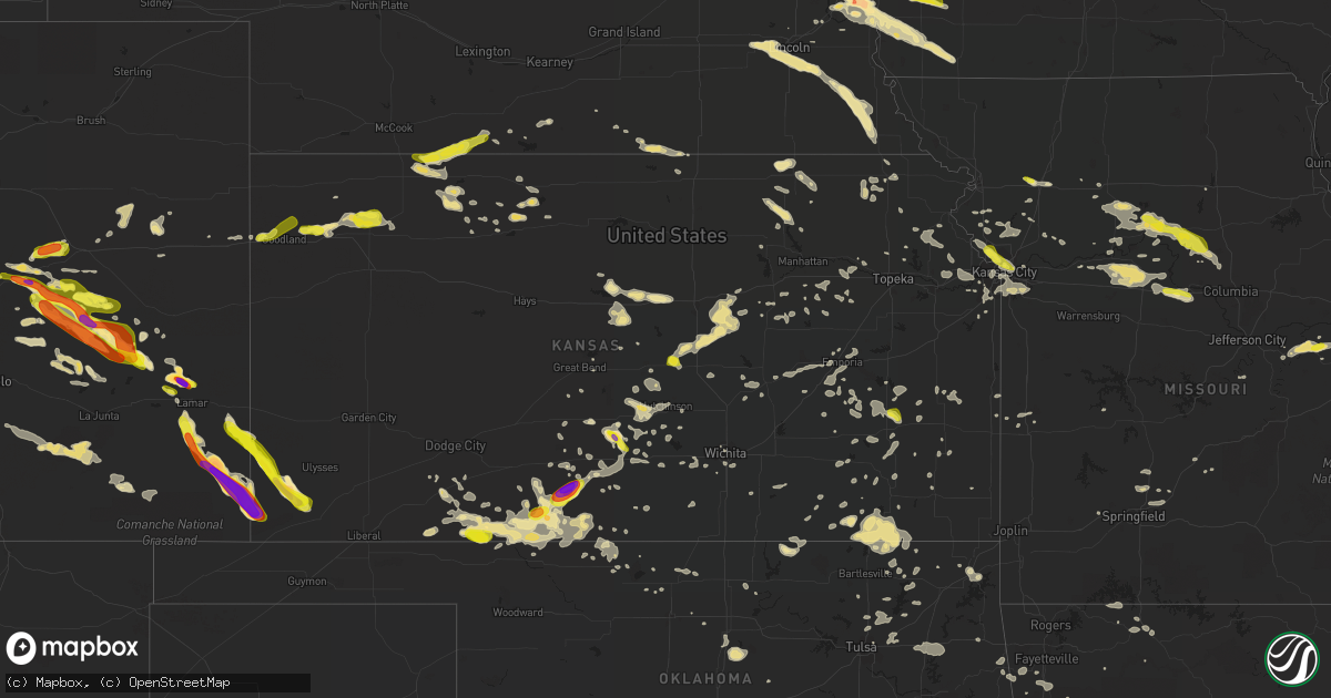
Hail Map in Kansas on June 29, 2017
Get this storm
June 29 map
$229
one time, instant access
Download today. No call, no setup
Keep the $229
Bought the map and want the full workflow? Apply the entire $229 to a subscription within 7 days. None of it is wasted.
Every map, not just this one
This buys you this map. Subscription and you get every map we run, in the markets you choose from a few cities to whole states to nationwide. Plus real-time alerts the moment a storm fires.
Contact data
Name, contact info, occupancy, even credit band for addresses in the footprint. You go from where it hit to who to call.
Become the source they trust
Unlimited branding weather history reports on demand. You already have the documented answer ready for the property owner, and you are the one who showed up with it.
Property data and RoofTrace estimates
Pull up any address you have got, its value and the exact code rules for that jurisdiction, straight from One Click Code. Then RoofTrace estimates the squares, pitch, and roof value, priced the way you price.
Storm reports in Kansas
Kansas
| Date | Description |
|---|---|
| 06/29/20174:00 AM CDT | Delayed report. |
| 06/29/20173:43 AM CDT | Delayed report - metal barn destroyed with numerous tree limbs snapped |
| 06/29/20173:41 AM CDT | Semi truck blown into ditch on hwy 69 at mile marker 109. Wind damage extends down hwy 69 to pleasanton. |
| 06/29/20173:41 AM CDT | Garage blown in along with multiple trees down. |
| 06/29/20173:36 AM CDT | A few larger limbs up to 4 inches in diameter blown out of trees. |
| 06/29/20172:46 AM CDT | Corrected for time |
| 06/29/20172:40 AM CDT | Trees and power lines were blown down across town. The report was received at 320 am cdt. |
| 06/29/20172:38 AM CDT | Corrected for time |
| 06/29/20171:58 AM CDT | A local report indicates 60 MPH wind near 1 E CALDWELL |
| 06/29/20171:46 AM CDT | A local report indicates 58 MPH wind near CHANUTE |
| 06/29/20171:46 AM CDT | A local report indicates 69 MPH wind near MCCONNELL AFB |
| 06/29/20171:22 AM CDT | A local report indicates 60 MPH wind near 6 ENE BLUFF CITY |
| 06/29/20171:13 AM CDT | Barn roofs were blown off and widespread tree damage occurred. Power still was out in the city of kiowa at 0945 am. |
| 06/29/20171:13 AM CDT | Winds to 93 mph were measured by a home weather station before it blew away. |
| 06/29/201712:45 AM CDT | Numerous limbs up to three inches in diameter were blown from trees. Hail of unknown size stripped leaves from corn. |
| 06/29/201712:41 AM CDT | Tree limbs down and a damaged swing set. |
| 06/29/201712:30 AM CDT | 3-4 inch tree limbs down as well. |
| 06/29/201712:10 AM CDT | Tree limbs at least 4 inches in diameter were blown down. |
| 06/29/201712:02 AM CDT | A local report indicates 64 MPH wind near SALINA |
| 06/29/201712:01 AM CDT | A local report indicates 62 MPH wind near HUTCHINSON |
| 06/28/201711:45 PM CDT | Report recived via social media. |
| 06/28/201711:40 PM CDT | A local report indicates 1.50 inch wind near 8 ESE ACRES |
| 06/28/201711:40 PM CDT | Reported received via social media. |
| 06/28/201711:10 PM CDT | Tree limbs at least 4 inches in diameter were blown down. |
| 06/28/201711:09 PM CDT | A local report indicates 1.50 inch wind near 7 ESE COLDWATER |
| 06/28/201711:06 PM CDT | A local report indicates 2.75 inch wind near 3 NNE SUN CITY |
| 06/28/201710:55 PM CDT | A local report indicates 1.75 inch wind near SUN CITY |
| 06/28/201710:34 PM CDT | A local report indicates 2.75 inch wind near 13 WSW RICHFIELD |
| 06/28/20179:26 PM CDT | A local report indicates 1.00 inch wind near 10 NNW FETERITA |
| 06/28/20179:10 PM CDT | A local report indicates 3.00 inch wind near 12 NNE RICHFIELD |
| 06/28/20178:51 PM CDT | A local report indicates 1.75 inch wind near 3 NE MANTER |
| 06/28/20178:44 PM CDT | A local report indicates 1.75 inch wind near 3 N MANTER |
| 06/28/20178:22 PM CDT | Site selde2 measured wind gust of 60 mph. |
| 06/28/20178:07 PM CDT | Storm spotter...ray duffey... Measured 62.6 mph on a handheld anemometer. |
| 06/28/20178:01 PM CDT | Cwop site f0981 measured 62 mph wind gust. |
| 06/28/20178:00 PM CDT | Kksrexfo2 mesonet site at fdk plant measured 61 mph wind gust. |
| 06/28/20177:39 PM CDT | A local report indicates 60 MPH wind near 9 N YATES CENTER |
| 06/28/20177:39 PM CDT | A local report indicates 1.00 inch wind near 9 N YATES CENTER |
All States Impacted by Hail Map on June 29, 2017
Cities Impacted by Hail Map on June 29, 2017
- Elk Creek, NE
- Sterling, NE
- Cook, NE
- Burr, NE
- Douglas, NE
- Tecumseh, NE
- Humboldt, NE
- Auburn, NE
- Johnson, NE
- Dawson, NE
- Haviland, KS
- Bellevue, NE
- Calhan, CO
- Ramah, CO
- Matheson, CO
- Walsh, CO
- Granada, CO
- Manter, KS
- Two Buttes, CO
- Elkhart, KS
- Lamar, CO
- Pisgah, IA
- Tekamah, NE
- Model, CO
- Turon, KS
- Cunningham, KS
- Jesup, IA
- Independence, IA
- Mcpherson, KS
- Windom, KS
- Round Lake, MN
- Harris, IA
- Cissna Park, IL
- Wagner, SD
- Scribner, NE
- Hooper, NE
- Craig, NE
- West Point, NE
- Oakland, NE
- Hartley, IA
- Everly, IA
- Spencer, IA
- Chambers, NE
- Amelia, NE
- Gypsum, KS
- Lindsborg, KS
- Sylvan Grove, KS
- Lincoln, KS
- Karval, CO
- Paxton, IL
- Gayville, SD
- Holly, CO
- Richfield, KS
- Johnson, KS
- Wiley, CO
- Eads, CO
- Platte City, MO
- Wilmore, KS
- Morse Bluff, NE
- Slater, MO
- Petersburg, NE
- Elgin, NE
- Tilden, NE
- Oakdale, NE
- Offutt Afb, NE
- La Vista, NE
- Papillion, NE
- Omaha, NE
- Pierce, NE
- Neligh, NE
- Osmond, NE
- Plainview, NE
- Lucas, KS
- Haswell, CO
- Colby, KS
- Pratt, KS
- Miami, OK
- Afton, OK
- Fairland, OK
- Fair Grove, MO
- Hugo, CO
- Marthasville, MO
- Stilwell, OK
- Canehill, AR
- Westville, OK
- Lincoln, AR
- Meade, KS
- Lake City, KS
- Sun City, KS
- Coats, KS
- Ewing, NE
- Agate, CO
- Simla, CO
- Lake Andes, SD
- Armour, SD
- Mead, NE
- Cedar Bluffs, NE
- Colon, NE
- Fremont, NE
- Logan, IA
- Persia, IA
- Ordway, CO
- Sugar City, CO
- Olney Springs, CO
- Oologah, OK
- Wynot, NE
- Vermillion, SD
- Newcastle, NE
- Corsica, SD
- Tripp, SD
- Avon, SD
- Scotland, SD
- Lincoln, NE
- Bennet, NE
- Martell, NE
- Pleasant Dale, NE
- Roca, NE
- Adams, NE
- Hickman, NE
- Milford, NE
- Seward, NE
- Palmyra, NE
- Denton, NE
- Stanton, NE
- Madison, NE
- Winchester, KS
- McLouth, KS
- Nortonville, KS
- Valley Falls, KS
- Pilger, NE
- Wisner, NE
- Loda, IL
- Little Sioux, IA
- Mondamin, IA
- Missouri Valley, IA
- Fort Calhoun, NE
- Dodge, NE
- Clarkson, NE
- Howells, NE
- Abbyville, KS
- Saybrook, IL
- Macedonia, IA
- Henderson, IA
- Peabody, KS
- Florence, KS
- Shidler, OK
- Stamford, NE
- Naponee, NE
- Waterloo, NE
- Yutan, NE
- Elkhorn, NE
- Randolph, IA
- Council Bluffs, IA
- Glenwood, IA
- Plattsmouth, NE
- Springfield, NE
- Malvern, IA
- Malmo, NE
- Imogene, IA
- Pacific Junction, IA
- Lathrop, MO
- Alta Vista, KS
- Fordyce, NE
- Crofton, NE
- Saint Helena, NE
- Linn, MO
- Fall River, KS
- Severy, KS
- Howard, KS
- Glade, KS
- Phillipsburg, KS
- Pretty Prairie, KS
- Tyndall, SD
- Springfield, SD
- Harrison, AR
- Goff, KS
- Seneca, KS
- Chapman, KS
- Eskridge, KS
- Boonville, MO
- Pilot Grove, MO
- Alden, IA
- Iowa Falls, IA
- Lyons, NE
- Decatur, NE
- Coyle, OK
- Orlando, OK
- Stillwater, OK
- Mulhall, OK
- Sibley, IL
- Republic, KS
- Byron, NE
- Superior, NE
- Webber, KS
- Guide Rock, NE
- Hardy, NE
- Blue Rapids, KS
- Barnes, KS
- Waterville, KS
- Randolph, KS
- Greenleaf, KS
- Malta Bend, MO
- Woodbine, IA
- Onawa, IA
- Blencoe, IA
- Moorhead, IA
- Colorado Springs, CO
- Yoder, CO
- Carter Lake, IA
- Bennington, NE
- Blair, NE
- Ames, NE
- Pender, NE
- Rogers, NE
- Elliott, IA
- Kennard, NE
- Leigh, NE
- Red Oak, IA
- Schuyler, NE
- Neola, IA
- Battle Creek, NE
- Meadow Grove, NE
- Uehling, NE
- Carson, IA
- Honey Creek, IA
- Wakefield, NE
- Wayne, NE
- Bancroft, NE
- Winside, NE
- Arlington, NE
- Harlan, IA
- Silver City, IA
- Modale, IA
- Emerson, IA
- Creston, NE
- Snyder, NE
- Treynor, IA
- Washington, NE
- Shelby, IA
- North Bend, NE
- Beemer, NE
- Crescent, IA
- Nickerson, NE
- Columbus, NE
- Hoskins, NE
- Herman, NE
- Emerson, NE
- Norfolk, NE
- Underwood, IA
- Portsmouth, IA
- Thurston, NE
- Valley, NE
- Stafford, KS
- Strafford, MO
- Wichita, KS
- Kingman, KS
- Lenora, KS
- Oneill, NE
- Akron, IA
- Hawarden, IA
- Ireton, IA
- Olathe, KS
- South Sioux City, NE
- Sergeant Bluff, IA
- Sioux City, IA
- Armstrong, MO
- Harrisburg, MO
- De Witt, MO
- Clark, MO
- Mendon, MO
- Fayette, MO
- Glasgow, MO
- Triplett, MO
- Keytesville, MO
- Brunswick, MO
- Salisbury, MO
- Dalton, MO
- Higbee, MO
- Bosworth, MO
- Hill City, KS
- Green Forest, AR
- Geddes, SD
- Eureka, KS
- Essex, IA
- Clarinda, IA
- Yorktown, IA
- Shenandoah, IA
- Rush, CO
- Republican City, NE
- Catoosa, OK
- Claremore, OK
- Westphalia, KS
- Le Roy, KS
- Burlington, KS
- Limon, CO
- Elbert, CO
- Hardtner, KS
- Medicine Lodge, KS
- Wilsonville, NE
- Norcatur, KS
- Norton, KS
- Oberlin, KS
- Hendley, NE
- Prairie Village, KS
- Kansas City, KS
- Lees Summit, MO
- Leawood, KS
- Overland Park, KS
- Kansas City, MO
- Verdigre, NE
- Lorraine, KS
- Wilson, KS
- Holyrood, KS
- Ellsworth, KS
- Rolfe, IA
- Bradgate, IA
- Haven, KS
- Lance Creek, WY
- Oxford, NE
- Beaver City, NE
- Alcester, SD
- Parsons, KS
- Galesburg, KS
- Mission Hill, SD
- Volin, SD
- Carrollton, MO
- Chillicothe, MO
- Bogard, MO
- Hale, MO
- Clifton Hill, MO
- Tina, MO
- Sumner, MO
- Dawn, MO
- Ross, ND
- Elk Point, SD
- Lexington, MO
- Fowler, KS
- Merrill, IA
- Le Mars, IA
- Hinton, IA
- Kingsley, IA
- Belleville, KS
- Westfield, IA
- Yankton, SD
- Ashland, KS
- New Town, ND
- Maurice, IA
- Jefferson, SD
- Hanover, KS
- Dakota City, NE
- North Sioux City, SD
- Soldier, IA
- Castana, IA
- Home, KS
- Marysville, KS
- Independence, MO
- Danbury, IA
- Dodgeville, WI
- Ridgeway, WI
- Solomon, KS
- Salina, KS
- Abilene, KS
- Tabor, SD
- Hampton, IA
- Sheffield, IA
- Latimer, IA
- Brewster, KS
- Osceola, MO
- Mountainburg, AR
- Fort Scott, KS
- Olsburg, KS
- Sterling, KS
- Hornick, IA
- Moville, IA
- Havana, KS
- Covington, OK
- Reading, KS
- Emporia, KS
- Nash, OK
- Talala, OK
- Dorrance, KS
- Parshall, ND
- Saint Elizabeth, MO
- Hull, IA
- Rock Valley, IA
- Cameron, MO
- Kidder, MO
- Harrison, SD
- Burlington, CO
- Kanorado, KS
- Hasty, CO
- McClave, CO
- Whiting, KS
- Smithland, IA
- Lenexa, KS
- Bonner Springs, KS
- Pritchett, CO
- Clearwater, NE
- Alexander, IA
- Osborn, MO
- Matfield Green, KS
- Jackson, NE
- Ponca, NE
- Anthon, IA
- Climbing Hill, IA
- Lawton, IA
- Bronson, IA
- Vail, IA
- Perry, OK
- Macksville, KS
- Minneola, KS
- Nisland, SD
- Ruthven, IA
- Nashville, KS
- Derby, KS
- Herington, KS
- White City, KS
- Rolla, KS
- Hugoton, KS
- Beverly, KS
- Witter, AR
- Sutherland, IA
- Kim, CO
- Nickerson, KS
- Partridge, KS
- Hutchinson, KS
- Linwood, KS
- Shawnee, KS
- Basehor, KS
- Tonganoxie, KS
- Edson, KS
- Levant, KS
- Clayton, KS
- Jennings, KS
- Dearborn, MO
- De Kalb, MO
- Chelsea, OK
- Nowata, OK
- Pond Creek, OK
- Stanley, ND
- Anchor, IL
- Girard, KS
- Sidney, IA
- Prague, NE
- Hastings, IA
- Linwood, NE
- Coin, IA
- Tabor, IA
- Gretna, NE
- Elk City, KS
- Kentland, IN
- Hartington, NE
- Dwight, KS
- Junction City, KS
- Marshfield, MO
- Neosho Falls, KS
- Yates Center, KS
- Stark, KS
- Peru, KS
- Sedan, KS
- Brookville, KS
- Kaylor, SD
- Delmont, SD
- Washington, MO
- Ocheyedan, IA
- Newkirk, OK
- Gibson City, IL
- Arrowsmith, IL
- Hope, KS
- Marshall, MO
- Nelson, MO
- Alton, IA
- Hospers, IA
- Blackburn, MO
- Woodston, KS
- Woodbine, KS
- Milford, IA
- Bradford, IA
- Dows, IA
- Trinidad, CO
- Marquette, KS
- Flagler, CO
- Watts, OK
- Sanborn, IA
- Archer, IA
- Carmel, IN
- Noblesville, IN
- Louisville, NE
- Orange City, IA
- St John, KS
- Kit Carson, CO
- Protection, KS
- Stockton, KS
- Frankfort, KS
- Hazelton, KS
- Morrill, KS
- Sabetha, KS
- Madison, KS
- Olpe, KS
- Coffeyville, KS
- Murdock, KS
- Clarion, IA
- Lyons, KS
- Fowler, CO
- Greenville, IA
- Ayrshire, IA
- Royal, IA
- Primghar, IA
- Dickens, IA
- Englewood, KS
- Allen, NE
- Oto, IA
- Hubbard, NE
- Waterbury, NE
- Wann, OK
- Copan, OK
- Seibert, CO
- Rock, KS
- Atlanta, KS
- Dexter, KS
- Maple City, KS
- Cedar Vale, KS
- Lindon, CO
- Arriba, CO
- Anton, CO
- Sweet Springs, MO
- Gem, KS
- Dunlap, IA
- Avoca, IA
- Great Bend, KS
- Richmond, MO
- Rayville, MO
- Hamilton, KS
- Virgil, KS
- Sperry, OK
- Skiatook, OK
- Owasso, OK
- Sioux Center, IA
- Bremen, KS
- Kincaid, KS
- Plevna, KS
- South Hutchinson, KS
- Buffalo, OK
- Rosston, OK
- Battle Creek, IA
- Correctionville, IA
- Coldwater, KS
- Genoa, CO
- Milan, KS
- Argonia, KS
- Rossville, KS
- Faucett, MO
- Olivet, SD
- Parkston, SD
- New Holland, SD
- Dearing, KS
- Tyro, KS
- Niotaze, KS
- Caney, KS
- Independence, KS
- S Coffeyville, OK
- Lander, WY
- Arapahoe, WY
- Riverton, WY
- Fort Washakie, WY
- Salix, IA
- Ludlow, MO
- Alva, OK
- Burlington, OK
- Winnebago, NE
- Homer, NE
- Melvin, IL
- Milford, IL
- Rankin, IL
- Elliott, IL
- Buckley, IL
- Wellington, IL
- Hoopeston, IL
- McDonald, KS
- Atwood, KS
- Ryder, ND
- Meta, MO
- Assaria, KS
- Smithville, MO
- Hermann, MO
- Mount Sterling, MO
- Morrison, MO
- Sloan, IA
- Rodney, IA
- Boyden, IA
- Mapleton, IA
- Fairview, KS
- Lamont, OK
- Medford, OK
- West Fork, AR
- Prairie Grove, AR
- Melvin, IA
- Enid, OK
- Blue Eye, MO
- Berryville, AR
- Oak Grove, AR
- Curlew, IA
- Mallard, IA
- Chamois, MO
- Owensville, MO
- Lawrence, KS
- Riverside, MO
- Centralia, IL
- Sandoval, IL
- Holt, MO
- Trimble, MO
- Kearney, MO
- Meriden, KS
- Hume, MO
- Whiting, IA
- Half Way, MO
- Buffalo, MO
- Omaha, AR
- Alpena, AR
- Peyton, CO
- Blackwater, MO
- Wetmore, KS
- Lynch, NE
- Marland, OK
- Sawyer, KS
- Erie, KS
- Cummings, KS
- Lindsay, NE
- Humphrey, NE
- Elsmore, KS
- Arlington, CO
- Higginsville, MO
- Kiowa, KS
- Stuart, NE
- De Soto, KS
- Emmet, NE
- Iuka, KS
- Delaware, OK
- Alma, MO
- Winslow, AR
- Cherokee, OK
- Burrton, KS
- Sylvia, KS
- Belle Fourche, SD
- Augusta, MO
- Defiance, MO
- Utica, MO
- Toronto, KS
- Monticello, IN
- Monon, IN
- Atkinson, NE
- Fredonia, KS
- Freedom, OK
- Lawton, ND
- Bartlett, NE
- Colony, KS
- Laurens, IA
- Utica, SD
- Burbank, SD
- Lenapah, OK
- Hancock, IA
- Buffalo, SD
- Bladen, NE
- Raymond, NE
- Colfax, IN
- Thorntown, IN
- Rexford, KS
- Council Grove, KS
- Dorchester, IA
- Cedar Creek, NE
- Excelsior Springs, MO
- Lawson, MO
- Greenwood, NE
- Walker, MO
- Udall, KS
- Waverly, MO
- Tryon, OK
- Agra, OK
- Blue Mound, KS
- Centerville, KS
- Gerald, MO
- New Haven, MO
- Ash Grove, MO
- Ackley, IA
- Walthill, NE
- Cope, CO
- Geneseo, KS
- Waldron, KS
- Galt, IA
- Spring Hill, KS
- Attica, KS
- Nevada, MO
- Richards, MO
- Jasper, AR
- Pierson, IA
- Alma, KS
- Greeley, CO
- Galva, KS
- Canton, KS
- Fowler, IN
- Remington, IN
- Bluejacket, OK
- Iola, KS
- Tulsa, OK
- Rich Hill, MO
- Dixon, NE
- Garnett, KS
- Collinsville, OK
- Paxico, KS
- Maple Hill, KS
- Breckenridge, MO
- Cheney, KS
- Goodland, KS
- Beresford, SD
- Damar, KS
- Isabel, KS
- Fithian, IL
- Covington, IN
- Veedersburg, IN
- Piqua, KS
- Gridley, KS
- Turney, MO
- Vinita, OK
- Ogden, IL
- Lebanon, MO
- Orleans, NE
- Menno, SD
- Longton, KS
- Byers, KS
- Edgerton, MO
- Harper, KS
- Selden, KS
- Grenola, KS
- Moline, KS
- Perrysville, IN
- De Soto, WI
- Bethune, CO
- Goddard, KS
- Viola, KS
- Clearwater, KS
- Corder, MO
- Concordia, MO
- Norborne, MO
- Ensign, KS
- Pleasant Hope, MO
- Potomac, IL
- Rossville, IL
- Hiawatha, KS
- Americus, KS
- Grovespring, MO
- Ponca City, OK
- Luray, KS
- Eagle, NE
- Lesterville, SD
- Marion, KS
- Hillsboro, KS
- Blue Hill, NE
- Camden Point, MO
- Rosebud, MO
- Logan, KS
- George, IA
- Leonardville, KS
- Bushton, KS
- Macy, NE
- Humboldt, IA
- Livermore, IA
- Cherryvale, KS
- Altoona, KS
- Kansas, OK
- Twin Oaks, OK
- Colcord, OK
- Mullinville, KS
- Strong City, KS
- Cottonwood Falls, KS
- Elmdale, KS
- Cedar Point, KS
- Sheldon, IA
- Buffalo, KS
- Park Rapids, MN
- Garden Plain, KS
- Minden, IA
- Panama, IA
- Pleasanton, KS
- Larkspur, CO
- Enterprise, KS
- Ellinwood, KS
- Bevier, MO
- Popejoy, IA
- Coulter, IA
- Geneva, IA
- Chapin, IA
- Sturgis, SD
- Scandia, KS
- Inola, OK
- Chouteau, OK
- Locust Grove, OK
- Saint Joseph, IL
- Farley, MO
- Weston, MO
- Dante, SD
- Hoyt, KS
- Belmond, IA
- Bogue, KS
- Clay Center, KS
- Syracuse, KS
- Hildreth, NE
- Bloomington, NE
- Walton, KS
- Syracuse, NE
- Leavenworth, KS
- Wolcott, IN
- Saint Marys, KS
- Odin, IL
- Salem, IL
- New Albin, IA
- Lansing, IA
- Sibley, IA
- Ashton, IA
- Arlington, KS
- Griswold, IA
- Chanute, KS
- Barnsdall, OK
- Springfield, CO
- Huntsville, MO
- Farragut, IA
- Platte, SD


