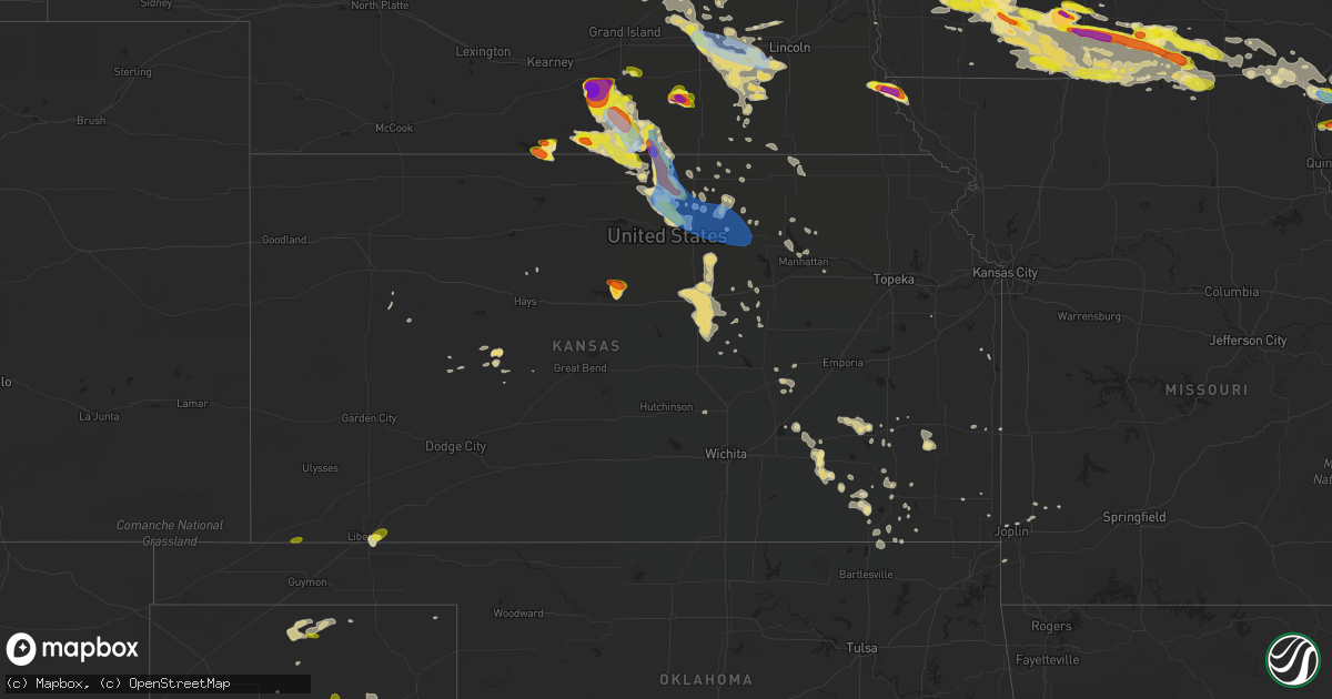
Hail Map in Kansas on June 25, 2019
Get this storm
June 25 map
$229
one time, instant access
Download today. No call, no setup
Keep the $229
Bought the map and want the full workflow? Apply the entire $229 to a subscription within 7 days. None of it is wasted.
Every map, not just this one
This buys you this map. Subscription and you get every map we run, in the markets you choose from a few cities to whole states to nationwide. Plus real-time alerts the moment a storm fires.
Contact data
Name, contact info, occupancy, even credit band for addresses in the footprint. You go from where it hit to who to call.
Become the source they trust
Unlimited branding weather history reports on demand. You already have the documented answer ready for the property owner, and you are the one who showed up with it.
Property data and RoofTrace estimates
Pull up any address you have got, its value and the exact code rules for that jurisdiction, straight from One Click Code. Then RoofTrace estimates the squares, pitch, and roof value, priced the way you price.
Storm reports in Kansas
Kansas
| Date | Description |
|---|---|
| 06/25/20196:29 PM CDT | Nickel to quarter hail. |
| 06/25/20197:43 AM CDT | A local report indicates 1.00 inch wind near 4 SSE HAYNE |
| 06/25/20196:30 AM CDT | At 1130 PM CDT, a severe thunderstorm was located over Sylvan Grove, or 10 miles north of Wilson, moving southeast at 10 mph. HAZARD...Ping pong ball size hail and 60 mph wind gusts. SOURCE...Radar indicated. IMPACT...People and animals outdoors will be injured. Expect hail damage to roofs, siding, windows, and vehicles. Expect wind damage to roofs, siding, and trees. Locations impacted include... Wilson, Lincoln, Sylvan Grove, Wilson State Park and Wilson Lake. This includes Interstate 70 between Mile Markers 203 and 222. |
| 06/25/20195:50 AM CDT | At 1050 PM CDT, a severe thunderstorm was located over Culver, or 11 miles northwest of Salina, moving east at 15 mph. HAZARD...Golf ball size hail and 60 mph wind gusts. SOURCE...Radar indicated. IMPACT...People and animals outdoors will be injured. Expect hail damage to roofs, siding, windows, and vehicles. Expect wind damage to roofs, siding, and trees. Locations impacted include... Salina and New Cambria. This includes the following highways... Interstate 135 between Mile Markers 93 and 95. Interstate 70 between Mile Markers 242 and 266. |
| 06/25/20195:23 AM CDT | At 1023 PM CDT, a severe thunderstorm was located over Sylvan Grove, or 12 miles north of Wilson, moving southeast at 20 mph. HAZARD...Ping pong ball size hail and 60 mph wind gusts. SOURCE...Radar indicated. IMPACT...People and animals outdoors will be injured. Expect hail damage to roofs, siding, windows, and vehicles. Expect wind damage to roofs, siding, and trees. Locations impacted include... Ellsworth, Kanopolis, Lincoln, Sylvan Grove, Beverly, Westfall, Wilson State Park, Ellsworth Airport and Wilson Lake.This includes Interstate 70 between Mile Markers 208 and 233. |
| 06/25/20194:56 AM CDT | At 955 PM CDT, severe thunderstorms were located along a line extending from 6 miles east of Westmoreland to near St. George to 9 miles southeast of Ogden, moving southeast at 45 mph. HAZARD...60 mph wind gusts. SOURCE...Radar indicated. IMPACT...Expect damage to roofs, siding, and trees. Locations impacted include... Manhattan, Wamego, Rossville, Alma, Westmoreland, Eskridge, St. Marys, Dover, Silver Lake, St. George, Maple Hill, McFarland, Paxico, Belvue, Louisville, Allen, Willard, Keene and Volland.This includes Interstate 70 between mile markers 312 and 353. |
| 06/25/20194:01 AM CDT | At 901 PM CDT, a severe thunderstorm was located over Randall, or 14 miles north of Beloit, moving southeast at 40 mph. HAZARD...60 mph wind gusts and half dollar size hail. SOURCE...Radar indicated. IMPACT...Hail damage to vehicles is expected. Expect wind damage to roofs, siding, and trees. Locations impacted include... Jewell, Simpson, Randall and Scottsville. |
| 06/25/20193:59 AM CDT | At 858 PM CDT, severe thunderstorms were located along a line extending from 4 miles south of Greenleaf to 4 miles east of Morganville to 4 miles east of Miltonvale, moving southeast at 40 mph. HAZARD...60 mph wind gusts. SOURCE...Radar indicated. IMPACT...Expect damage to roofs, siding, and trees. Locations impacted include... Manhattan, Junction City, Abilene, Clay Center, Ogden, Grandview Plaza, Chapman, Wakefield, Riley, Enterprise, Miltonvale, Milford, Leonardville, Olsburg, Morganville, Randolph, Green, Manchester, Longford and Oak Hill.This includes Interstate 70 between mile markers 276 and 313. |
| 06/25/20193:38 AM CDT | At 838 PM CDT, a severe thunderstorm was located over Scottsville, or 9 miles northeast of Beloit, moving southeast at 25 mph. HAZARD...60 mph wind gusts and half dollar size hail. SOURCE...Radar indicated. IMPACT...Hail damage to vehicles is expected. Expect wind damage to roofs, siding, and trees. Locations impacted include... Scottsville. |
| 06/25/20193:29 AM CDT | At 829 PM CDT, severe thunderstorms were located along a line extending from 6 miles northeast of Agenda to 6 miles west of Clyde to 4 miles northeast of Asherville, moving southeast at 35 mph. HAZARD...60 mph wind gusts and half dollar size hail. SOURCE...Radar indicated. IMPACT...Hail damage to vehicles is expected. Expect wind damage to roofs, siding, and trees. Locations impacted include... Concordia, Clay Center, Clyde, Clifton, Miltonvale, Glasco, Delphos, Jamestown, Morganville, Green, Palmer, Agenda, Aurora, Vining, Oak Hill, Idana and Ada. |
| 06/25/20193:14 AM CDT | At 814 AM CDT, a severe thunderstorm was located near Ness City, moving east at 25 mph. HAZARD...Quarter size hail. SOURCE...Radar indicated. IMPACT...Damage to vehicles is expected. Locations impacted include... Ness City and Bazine. |
| 06/25/20193:12 AM CDT | At 812 PM CDT, a severe thunderstorm was located near Mankato, or 25 miles north of Beloit, moving southeast at 25 mph. HAZARD...Ping pong ball size hail and 60 mph wind gusts. SOURCE...Radar indicated. IMPACT...People and animals outdoors will be injured. Expect hail damage to roofs, siding, windows, and vehicles. Expect wind damage to roofs, siding, and trees. Locations impacted include... Mankato, Formoso, Randall and Montrose. |
| 06/25/20192:56 AM CDT | At 755 PM CDT, severe thunderstorms were located along a line extending from near Red Cloud to 6 miles south of Inavale to Riverton, moving south at 15 mph. HAZARD...Golf ball size hail and 60 mph wind gusts. SOURCE...Radar indicated. IMPACT...People and animals outdoors will be injured. Expect hail damage to roofs, siding, windows, and vehicles. Expect wind damage to roofs, siding, and trees. Locations impacted include... Red Cloud, Riverton and Inavale. |
| 06/25/20192:43 AM CDT | At 743 PM CDT, a severe thunderstorm was located 4 miles northwest of Courtland, moving southeast at 25 mph. HAZARD...Two inch hail and 60 mph wind gusts. SOURCE...Radar indicated. IMPACT...People and animals outdoors will be injured. Expect hail damage to roofs, siding, windows, and vehicles. Expect wind damage to roofs, siding, and trees. Locations impacted include... Concordia, Scandia, Jamestown, Courtland and Norway. |
| 06/25/20192:35 AM CDT | At 734 AM CDT, a severe thunderstorm was located near Hayne, moving northeast at 15 mph. HAZARD...Quarter size hail. SOURCE...Radar indicated. IMPACT...Damage to vehicles is expected. Locations impacted include... Liberal, Kismet and Hayne. |
| 06/25/20192:27 AM CDT | At 727 PM CDT, severe thunderstorms were located along a line extending from near Riverton to near Red Cloud, moving southeast at 15 mph. HAZARD...Golf ball size hail and 60 mph wind gusts. SOURCE...Radar indicated. IMPACT...People and animals outdoors will be injured. Expect hail damage to roofs, siding, windows, and vehicles. Expect wind damage to roofs, siding, and trees. Locations impacted include... Red Cloud, Riverton and Inavale. |
| 06/25/20192:11 AM CDT | At 710 PM CDT, severe thunderstorms were located along a line extending from near Ruskin to Superior to near Guide Rock, moving southeast at 40 mph. HAZARD...Two inch hail and 60 mph wind gusts. SOURCE...Radar indicated. IMPACT...People and animals outdoors will be injured. Expect hail damage to roofs, siding, windows, and vehicles. Expect wind damage to roofs, siding, and trees. Locations impacted include... Superior, Mankato, Jewell, Chester, Burr Oak, Hardy, Ruskin, Formoso, Byron, Randall, Webber, Lovewell State Park, Montrose and Bostwick. |
| 06/25/20192:00 AM CDT | At 700 PM CDT, a severe thunderstorm was located near Superior, moving southeast at 20 mph. HAZARD...60 mph wind gusts and half dollar size hail. SOURCE...Radar indicated. IMPACT...Hail damage to vehicles is expected. Expect wind damage to roofs, siding, and trees. Locations impacted include... Scandia, Courtland and Republic. |
| 06/25/20191:40 AM CDT | At 640 PM CDT, a severe thunderstorm was located over Nelson, or 33 miles northwest of Belleville, moving southeast at 25 mph. HAZARD...Two inch hail and 60 mph wind gusts. SOURCE...Radar indicated. IMPACT...People and animals outdoors will be injured. Expect hail damage to roofs, siding, windows, and vehicles. Expect wind damage to roofs, siding, and trees. Locations impacted include... Deshler, Nelson, Hardy, Ruskin and Nora. |
| 06/25/20191:13 AM CDT | At 613 PM CDT, a severe thunderstorm was located near Cowles, or 27 miles south of Hastings, moving southeast at 20 mph. HAZARD...Two inch hail and 60 mph wind gusts. SOURCE...Radar indicated. IMPACT...People and animals outdoors will be injured. Expect hail damage to roofs, siding, windows, and vehicles. Expect wind damage to roofs, siding, and trees. Locations impacted include... Nelson, Lawrence, Guide Rock, Cowles and Bostwick. |
| 06/25/201912:08 AM CDT | A local report indicates 1.75 inch wind near 3 SSW SYLVAN GROVE |
| 06/24/201910:30 PM CDT | A local report indicates 1.75 inch wind near 3 ESE LUCAS |
| 06/24/20198:53 PM CDT | A local report indicates 1.25 inch wind near 6 S JAMESTOWN |
| 06/24/20198:40 PM CDT | Spotter confident in 60 mph winds. |
| 06/24/20197:56 PM CDT | Corrects time of the 7:47 pm hail report from formoso. More information was gathered via twitter. |
| 06/24/20197:50 PM CDT | Spotter was driving on highway 36 and confident that he experienced 60 mph wind gusts as the storm was passing over. |
| 06/24/20197:50 PM CDT | Pws station kksranda2. |
| 06/24/20197:50 PM CDT | A local report indicates 1.00 inch wind near 2 E WEBBER |
| 06/24/20197:47 PM CDT | A local report indicates 1.75 inch wind near FORMOSO |
| 06/24/20197:46 PM CDT | Spotter network report. |
| 06/24/20197:39 PM CDT | Corrected for additional information. Peak measured gust was 66 mph... But gusts were at least 70 mph. |
All States Impacted by Hail Map on June 25, 2019
Cities Impacted by Hail Map on June 25, 2019
- Benedict, KS
- Fredonia, KS
- Eunice, NM
- Hemingford, NE
- Veteran, WY
- Lingle, WY
- Torrington, WY
- Harrison, NE
- Morrill, NE
- Selma, AL
- Marion Junction, AL
- Farwell, NE
- Van Tassell, WY
- Panhandle, TX
- Amarillo, TX
- Sargent, NE
- Burwell, NE
- Toronto, KS
- Lost Springs, WY
- Shawnee, WY
- Manville, WY
- Marion, AL
- Centreville, AL
- Lawley, AL
- Lockney, TX
- Tulia, TX
- Silverton, TX
- Kress, TX
- Knoxville, IA
- Otley, IA
- Centerville, IA
- Mystic, IA
- Aladdin, WY
- Naponee, NE
- Exline, IA
- Moulton, IA
- Glenwood, MO
- Cincinnati, IA
- Unionville, MO
- Coatsville, MO
- Livonia, MO
- Weston, WY
- Spearfish, SD
- Moorcroft, WY
- Hulett, WY
- Alva, WY
- Belle Fourche, SD
- Saint Onge, SD
- Beulah, WY
- Sundance, WY
- Prescott, IA
- Gruver, TX
- Beloit, WI
- Lusk, WY
- Yates Center, KS
- Wann, OK
- Elliott, IA
- Sylvan Grove, KS
- Albia, IA
- Peoria Heights, IL
- Trivoli, IL
- Hanna City, IL
- Brimfield, IL
- Farmington, IL
- Peoria, IL
- Edwards, IL
- Elmwood, IL
- Conehatta, MS
- Lodge Grass, MT
- Claude, TX
- Wayside, TX
- Delaware, OK
- Donaldsonville, LA
- Genoa, NE
- Douds, IA
- Selma, IA
- La Harpe, IL
- Dallas City, IL
- Palmer, NE
- Wolbach, NE
- Argenta, IL
- Quitaque, TX
- Skellytown, TX
- Burr Oak, KS
- Guide Rock, NE
- Crete, NE
- Lewis, IA
- Brodhead, WI
- Afton, WI
- Durand, IL
- Rockton, IL
- Janesville, WI
- Hamshire, TX
- Winnie, TX
- Happy, TX
- Coyanosa, TX
- Liberty, MS
- Alexander, KS
- Bazine, KS
- Heartwell, NE
- Beloit, KS
- Blue Hill, NE
- Nelson, NE
- Bladen, NE
- Kenesaw, NE
- Glasco, KS
- Holstein, NE
- Campbell, NE
- Hardy, NE
- Jamestown, KS
- Courtland, KS
- Superior, NE
- Esbon, KS
- Scandia, KS
- Ayr, NE
- Jewell, KS
- Red Cloud, NE
- Concordia, KS
- Roseland, NE
- Inavale, NE
- Republic, KS
- Belleville, KS
- Juniata, NE
- Minden, NE
- Formoso, KS
- Webber, KS
- Norway, KS
- Glenvil, NE
- Lawrence, NE
- Lebanon, KS
- Mankato, KS
- Hastings, NE
- Riverton, NE
- Edgar, MT
- Bridger, MT
- Joliet, MT
- Corning, IA
- Green, KS
- Clyde, KS
- Clifton, KS
- Bradshaw, NE
- York, NE
- Garryowen, MT
- Saint Xavier, MT
- Brownville, NE
- Watson, MO
- Rock Port, MO
- Peru, NE
- Van Horn, TX
- Hamilton, KS
- Virgil, KS
- Bingham, NE
- Blandinsville, IL
- Albion, NE
- Petersburg, NE
- Turpin, OK
- Hugoton, KS
- Liberal, KS
- Everglades City, FL
- Humeston, IA
- Osceola, IA
- Corydon, IA
- Woodburn, IA
- Weldon, IA
- Osceola, NE
- Copan, OK
- Caney, KS
- Forgan, OK
- Primrose, NE
- Spalding, NE
- Howard, KS
- Red Oak, IA
- Griswold, IA
- Shannon City, IA
- Villisca, IA
- Diagonal, IA
- Cumberland, IA
- Massena, IA
- Grant, IA
- Orient, IA
- Lenox, IA
- Fontanelle, IA
- Creston, IA
- Bridgewater, IA
- South Bend, IN
- Macomb, IL
- Sciota, IL
- Bardolph, IL
- Adair, IL
- Saint Paul, NE
- Cedar Point, KS
- Dickinson, TX
- Greensboro, AL
- Gallion, AL
- Orlando, FL
- Oviedo, FL
- Murray, IA
- Thayer, IA
- Broken Bow, NE
- Sturgis, SD
- Fort Davis, TX
- Kellerton, IA
- Mount Ayr, IA
- Golden City, MO
- Grapevine, AR
- Sheridan, AR
- White Hall, AR
- Solomon, KS
- Bennington, KS
- Miltonvale, KS
- Minneapolis, KS
- Seminole, TX
- Elba, NE
- Greeley, NE
- Archer, NE
- Clarks, NE
- Central City, NE
- Fullerton, NE
- Cedar Rapids, NE
- Scotia, NE
- Ericson, NE
- Ord, NE
- Comstock, NE
- Brock, NE
- Julian, NE
- Nebraska City, NE
- Talmage, NE
- Auburn, NE
- Leon, IA
- Port Barre, LA
- Palmetto, LA
- Memphis, MO
- Cantril, IA
- Milton, IA
- Marathon, TX
- Fort Stockton, TX
- Chicago, IL
- Chelsea, OK
- Melrose, IA
- Russell, IA
- Moravia, IA
- Plano, IA
- Longton, KS
- Elk City, KS
- Deadwood, SD
- Whitewood, SD
- Canton, IL
- Glasford, IL
- Glenrock, WY
- Danvers, IL
- Carlock, IL
- Bloomington, IL
- Hudson, IL
- Normal, IL
- Alma, KS
- Wamego, KS
- Whitehouse, TX
- Sanford, FL
- Osyka, MS
- Edgemont, SD
- Hattiesburg, MS
- Geneva, NE
- Davenport, NE
- Edgar, NE
- Sutton, NE
- Ong, NE
- Shickley, NE
- Assaria, KS
- Tampa, KS
- Vidor, TX
- Carthage, IL
- Colchester, IL
- Anita, IA
- Wiota, IA
- Chariton, IA
- Kahoka, MO
- Farmington, IA
- Luray, MO
- Mount Sterling, IA
- Bonaparte, IA
- Eckerman, MI
- Shelby, NE
- Rising City, NE
- Swanton, NE
- De Witt, NE
- Wilber, NE
- Piedmont, KS
- Melrose Park, IL
- Fairbury, NE
- Aurora, CO
- Hillsboro, IA
- Diller, NE
- Steele City, NE
- Odell, NE
- Jay Em, WY
- Benedict, NE
- Stromsburg, NE
- Polk, NE
- Hampton, NE
- Goodwell, OK
- Miami, TX
- Rolling Prairie, IN
- New Carlisle, IN
- Baton Rouge, LA
- Western, NE
- Denton, NE
- Plymouth, NE
- Hordville, NE
- McCool Junction, NE
- Anselmo, NE
- Taylor, NE
- Milford, NE
- Elyria, NE
- Daykin, NE
- Tobias, NE
- Milligan, NE
- Seward, NE
- Saint Edward, NE
- Friend, NE
- Lindsay, NE
- Surprise, NE
- Silver Creek, NE
- Pleasant Dale, NE
- Cordova, NE
- Newman Grove, NE
- Waco, NE
- Marquette, NE
- Fairmont, NE
- Dorchester, NE
- Beaver Crossing, NE
- Belgrade, NE
- Martell, NE
- Utica, NE
- North Loup, NE
- Hallam, NE
- Dunning, NE
- Columbus, NE
- Ashton, NE
- Arcadia, NE
- Bartlett, NE
- Exeter, NE
- Roca, NE
- Goehner, NE
- Neodesha, KS
- Altoona, KS
- Mercer, MO
- Lineville, IA
- West Point, IL
- Bowen, IL
- Ellsworth, NE
- London Mills, IL
- Canton, KS
- S Coffeyville, OK
- Coffeyville, KS
- Canton, TX
- Lorimor, IA
- Nauvoo, IL
- Argyle, IA
- Keokuk, IA
- Wayland, MO
- Hamilton, IL
- Montrose, IA
- Clinton, LA
- Marysville, KS
- Bloomfield, IA
- Floris, IA
- Independence, KS
- Enterprise, KS
- Abilene, KS
- Marietta, IL
- Molino, FL
- Humboldt, KS
- Savonburg, KS
- Erie, KS
- Norwalk, IA
- Baker, FL
- Metamora, IL
- Elk Falls, KS
- Michigan City, IN
- Burns, KS
- Laurel Hill, FL
- Larned, KS
- Agra, KS
- Republican City, NE
- Kensington, KS
- Phillipsburg, KS
- Bloomington, NE
- El Dorado, KS
- Morganville, KS
- Salina, KS
- Lindsborg, KS
- New Cambria, KS
- Gypsum, KS
- Tescott, KS
- Clay Center, KS
- Glendo, WY
- Ewing, NE
- Ness City, KS
- Petal, MS
- Greensburg, LA
- Lead, SD
- Herington, KS
- Balko, OK
- Beaver, OK
- Spearman, TX
- Manhattan, KS
- Riley, KS
- Carbon, IA
- Van Wert, IA
- Seymour, IA
- Benton, IA
- Udell, IA
- Unionville, IA
- Drakesville, IA
- Ellston, IA
- Tingley, IA
- Cromwell, IA
- Powersville, MO
- Derby, IA
- Promise City, IA
- Afton, IA
- Davis City, IA
- Truro, IA
- Decatur, IA
- New Virginia, IA
- Lamoni, IA
- Clio, IA
- Redding, IA
- Allerton, IA
- Garden Grove, IA
- Millerton, IA
- Clearfield, IA
- Grand River, IA
- Blythedale, MO
- Cainsville, MO
- Marengo, IA
- Amana, IA
- New Sharon, IA
- Chambers, NE
- Gresham, NE
- Ulysses, NE
- Chanute, KS
- Agenda, KS
- Canyon, TX
- Cumming, IA
- Sedgwick, CO
- Baldwin City, KS
- Grove, OK
- Palmer, KS
- La Porte, IN
- Oelrichs, SD
- Hot Springs, SD
- Nowata, OK
- Helena, AR
- Clarendon, TX
- Groom, TX
- East Peoria, IL
- Donnellson, IA
- Mendon, IL
- Sutter, IL
- Eureka, IL
- Stanton, IA
- Denham Springs, LA
- Augusta, IL
- Plymouth, IL
- Basco, IL
- Raymond, NE
- Valparaiso, NE
- Niota, IL
- North Liberty, IN
- Randolph, KS
- Devils Tower, WY
- Mill Creek, IN
- Oak Park, IL
- Otter, MT
- Worthington, MO
- Burdett, KS
- Greenfield, IA
- Saint Francisville, LA
- Carson, IA
- Tyler, TX
- Carencro, LA
- Smithfield, IL
- Thayer, KS
- Covington, LA
- Haddam, KS
- West Blocton, AL
- Brierfield, AL
- Three Oaks, MI
- Lakeville, IN
- New Buffalo, MI
- Bremen, IN
- Forest, MS
- Lake, MS
- Decatur, MS
- Piedmont, SD
- Good Hope, IL
- Westmoreland, KS
- Eureka, KS
- Casey, IA
- Adair, IA
- Loraine, IL
- Avon, IL
- Industry, IL
- Bushnell, IL
- Crestview, FL
- Douglas, WY
- Natchez, MS
- Ursa, IL
- Grinnell, KS
- Decker, MT
- Leonardville, KS
- Springfield, LA
- Naples, FL
- Tennessee, IL
- Lomax, IL
- Ainsworth, IA
- Cuba, KS
- Fromberg, MT
- Gloster, MS
- Saint James, LA
- Fort Scott, KS
- Morrowville, KS
- Grenola, KS
- Lancaster, MO
- Hope, KS
- Magnolia, MS
- Amite, LA
- Prairie City, IL
- Nappanee, IN
- Columbia, MS
- Narka, KS
- Vinita, OK
- Eglin Afb, FL
- Newcastle, WY
- Chapman, KS
- Randall, KS
- Laverne, OK
- Joplin, MO
- Garland, NE
- Birmingham, IA
- Keosauqua, IA
- Iola, KS
- Washington, KS
- Liberty, KS
- Wahoo, NE
- Independence, LA
- Holden, LA
- Newberry, MI
- Lucas, IA
- Pulaski, IA
- Blockton, IA
- Nodaway, IA
- Sharpsburg, IA
- Emerson, IA
- Paola, KS
- Monticello, MS
- Monroe, IA
- Follett, TX
- Frostproof, FL
- Carthage, MO
- Perryton, TX
- Atlantic, IA
- Home, KS
- Fall River, KS
- Sherrill, AR
- Plattsmouth, NE
- Durham, KS
- Hermanville, MS
- Plainville, KS
- Barnes City, IA
- Washington, IL
- Hollywood, FL
- Franklin, NE
- Oak, NE
- Fairfield, NE
- Foxworth, MS
- Lettsworth, LA
- Mapleton, IL
- Woodbine, KS
- Gillett, AR
- Purvis, MS
- Wever, IA
- Karnack, TX
- Ellis, KS
- Dayton, TX
- Woodville, MS
- Sedan, KS
- Uniontown, AL
- Safford, AL
- Hammond, LA
- Prairieville, LA
- Gonzales, LA
- Morton, MS
- De Witt, AR
- Inland, NE
- Trumbull, NE
- Benton, AR
- Prattsville, AR
- Carterville, MO
- Webb City, MO
- La Harpe, KS
- Thomaston, AL
- Dewey, OK
- Port Charlotte, FL
- Quitman, MS
- Stinnett, TX
- Dundee, MS
- New Market, IA
- Bay Minette, AL
- Lonoke, AR
- Carlisle, AR
- Westville, FL
- Broadus, MT
- Miami, FL
- Faunsdale, AL
- Linden, AL
- Morganza, LA
- Batchelor, LA
- Kenansville, FL
- Merriman, NE
- Kissimmee, FL
- Marion, KS
- Hobbs, NM
- Alliance, NE
- Angora, NE
- Richton, MS
- Port Bolivar, TX
- Defuniak Springs, FL
- Exira, IA
- Saint Gabriel, LA
- Troup, TX
- Deltona, FL
- Seneca, MO
- Table Grove, IL
- Angola, LA
- La Cygne, KS
- McCune, KS
- Pittsburg, KS
- Halstead, KS
- Zolfo Springs, FL
- Havana, KS
- Cherryvale, KS
- Franklinton, LA
- Jasper, MO
- Fairview, IL
- Yates City, IL
- Uniontown, KS
- Redfield, KS
- Zachary, LA
- Maurepas, LA
- Clinton, IL
- Maroa, IL
- Pella, IA
- Pleasantville, IA
- Casper, WY
- Arbela, MO
- Fort Madison, IA
- Cuba, IL
- Warsaw, IL
- Omaha, NE
- Olsburg, KS
- Elmdale, KS
- Orange, TX
- Bremen, KS
- Oketo, KS
- Lake Wales, FL
- Roanoke, IL
- Sunray, TX
- England, AR
- Humnoke, AR
- Wabbaseka, AR
- Jansen, NE
- Columbus, KS
- Indianola, IA
- Haines City, FL
- Gove, KS
- Piqua, KS
- Borger, TX
- Kismet, KS
- Rolla, KS
- Guymon, OK
- Lance Creek, WY
- Lucas, KS
- Crawfordville, FL
- Aurora, KS
- Ipava, IL
- Elvaston, IL
- Peru, IA


