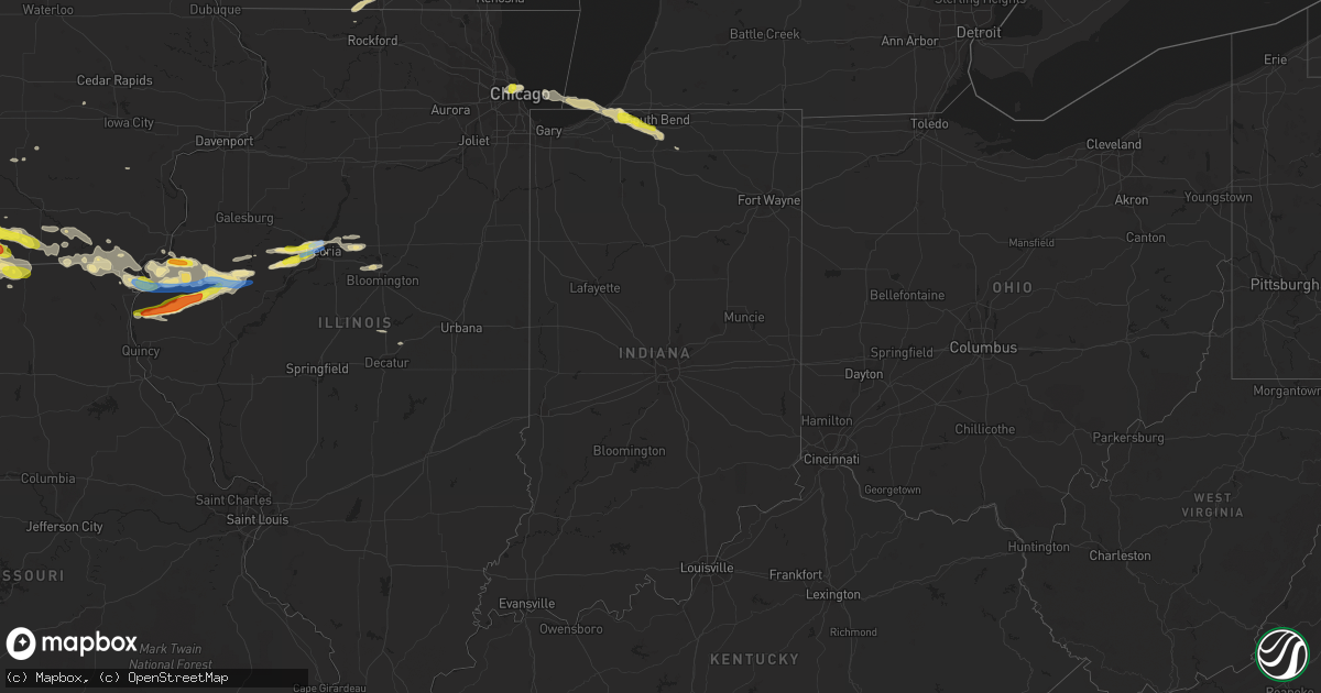
Hail Map in Indiana on June 25, 2019
Get this storm
June 25 map
$229
one time, instant access
Download today. No call, no setup
Keep the $229
Bought the map and want the full workflow? Apply the entire $229 to a subscription within 7 days. None of it is wasted.
Every map, not just this one
This buys you this map. Subscription and you get every map we run, in the markets you choose from a few cities to whole states to nationwide. Plus real-time alerts the moment a storm fires.
Contact data
Name, contact info, occupancy, even credit band for addresses in the footprint. You go from where it hit to who to call.
Become the source they trust
Unlimited branding weather history reports on demand. You already have the documented answer ready for the property owner, and you are the one who showed up with it.
Property data and RoofTrace estimates
Pull up any address you have got, its value and the exact code rules for that jurisdiction, straight from One Click Code. Then RoofTrace estimates the squares, pitch, and roof value, priced the way you price.
Storm reports in Indiana
Indiana
| Date | Description |
|---|---|
| 06/25/20196:45 PM CDT | A local report indicates 1.00 inch wind near NEW CARLISLE |
| 06/25/20193:11 AM CDT | At 811 PM EDT, a severe thunderstorm was located over Gulivoire Park, moving east at 30 mph. HAZARD...60 mph wind gusts and quarter size hail. SOURCE...Radar indicated. IMPACT...Hail damage to vehicles is expected. Expect wind damage to roofs, siding, and trees. Locations impacted include... South Bend, Mishawaka, Goshen, Nappanee, Bremen, Gulivoire Park, Wakarusa, Milford, Lakeville, New Paris, Locke, Hastings, Woodland, Southwest, Foraker, Gravelton, Waterford Mills and Wyatt. |
| 06/25/20192:44 AM CDT | At 744 PM EDT, a severe thunderstorm was located near Edwardsburg, or near Simonton Lake, moving southeast at 35 mph. HAZARD...60 mph wind gusts. SOURCE...Radar indicated. IMPACT...Expect damage to roofs, siding, and trees. Locations impacted include... Elkhart, Simonton Lake, Middlebury, Constantine, Cassopolis, Bristol, White Pigeon, Edwardsburg, Union, Mottville, Vandalia, Paradise Lake, Calvin Center, Adamsville, Juno Lake, Donnell Lake, Jones, Diamond Lake, Shavehead Lake and Eagle Lake.This includes Interstate 80 in Indiana between mile markers 89 and108. |
| 06/25/20192:24 AM CDT | At 724 PM EDT/624 PM CDT/, a severe thunderstorm was located near Three Oaks, or 7 miles northeast of La Porte, moving east at 35 mph. HAZARD...60 mph wind gusts and quarter size hail. SOURCE...Radar indicated. IMPACT...Hail damage to vehicles is expected. Expect wind damage to roofs, siding, and trees. Locations impacted include... South Bend, Mishawaka, La Porte, Georgetown, Granger, Gulivoire Park, North Liberty, New Carlisle, Three Oaks, Lakeville, Roseland, Galien, Indian Village, Byron, Union Pier, Hudson Lake, Chain-o-lakes, Rolling Prarie, Crumstown and Hesston.This includes the following highways... Interstate 80 in Indiana between mile markers 48 and 83. Interstate 94 in Michigan between mile markers 2 and 6. |
| 06/25/20192:11 AM CDT | At 710 PM EDT, a severe thunderstorm was located over Berrien Springs, or 9 miles north of Buchanan, moving east at 50 mph. HAZARD...60 mph wind gusts. SOURCE...Radar indicated. IMPACT...Expect damage to roofs, siding, and trees. Locations impacted include... Niles, Benton Harbor, St. Joseph, Dowagiac, Buchanan, Fair Plain, Bridgman, Berrien Springs, Cassopolis, Edwardsburg, Marcellus, Stevensville, Shorewood-Tower Hills-Harbert, Union, Bertrand, Pokagon, Sodus, Penn, Baroda and Eau Claire.This includes Interstate 94 in Michigan near mile marker 11, betweenmile markers 14 and 15, between mile markers 18 and 19, and betweenmile markers 24 and 30. |
| 06/25/20191:49 AM CDT | At 649 PM EDT/549 PM CDT/, a severe thunderstorm was located 7 miles north of Town Of Pines, or 7 miles northwest of Michigan City, moving east at 35 mph. HAZARD...60 mph wind gusts and quarter size hail. SOURCE...Radar indicated. IMPACT...Hail damage to vehicles is expected. Expect wind damage to roofs, siding, and trees. Locations impacted include... Michigan City, La Porte, Trail Creek, New Buffalo, New Carlisle, Three Oaks, Long Beach, Pottawattamie Park, Shorewood-Tower Hill, Shorewood-Tower Hills-Harbert, Dayton, Galien, Michiana Shores, Grand Beach, Michiana, Union Pier, Glendora, Waterford, New Troy and Harbert.This includes the following highways... Interstate 80 in Indiana between mile markers 44 and 67. Interstate 94 in Indiana between mile markers 33 and 45. Interstate 94 in Michigan between mile markers 0 and 13. |
All States Impacted by Hail Map on June 25, 2019
Cities Impacted by Hail Map on June 25, 2019
- Benedict, KS
- Fredonia, KS
- Eunice, NM
- Hemingford, NE
- Veteran, WY
- Lingle, WY
- Torrington, WY
- Harrison, NE
- Morrill, NE
- Selma, AL
- Marion Junction, AL
- Farwell, NE
- Van Tassell, WY
- Panhandle, TX
- Amarillo, TX
- Sargent, NE
- Burwell, NE
- Toronto, KS
- Lost Springs, WY
- Shawnee, WY
- Manville, WY
- Marion, AL
- Centreville, AL
- Lawley, AL
- Lockney, TX
- Tulia, TX
- Silverton, TX
- Kress, TX
- Knoxville, IA
- Otley, IA
- Centerville, IA
- Mystic, IA
- Aladdin, WY
- Naponee, NE
- Exline, IA
- Moulton, IA
- Glenwood, MO
- Cincinnati, IA
- Unionville, MO
- Coatsville, MO
- Livonia, MO
- Weston, WY
- Spearfish, SD
- Moorcroft, WY
- Hulett, WY
- Alva, WY
- Belle Fourche, SD
- Saint Onge, SD
- Beulah, WY
- Sundance, WY
- Prescott, IA
- Gruver, TX
- Beloit, WI
- Lusk, WY
- Yates Center, KS
- Wann, OK
- Elliott, IA
- Sylvan Grove, KS
- Albia, IA
- Peoria Heights, IL
- Trivoli, IL
- Hanna City, IL
- Brimfield, IL
- Farmington, IL
- Peoria, IL
- Edwards, IL
- Elmwood, IL
- Conehatta, MS
- Lodge Grass, MT
- Claude, TX
- Wayside, TX
- Delaware, OK
- Donaldsonville, LA
- Genoa, NE
- Douds, IA
- Selma, IA
- La Harpe, IL
- Dallas City, IL
- Palmer, NE
- Wolbach, NE
- Argenta, IL
- Quitaque, TX
- Skellytown, TX
- Burr Oak, KS
- Guide Rock, NE
- Crete, NE
- Lewis, IA
- Brodhead, WI
- Afton, WI
- Durand, IL
- Rockton, IL
- Janesville, WI
- Hamshire, TX
- Winnie, TX
- Happy, TX
- Coyanosa, TX
- Liberty, MS
- Alexander, KS
- Bazine, KS
- Heartwell, NE
- Beloit, KS
- Blue Hill, NE
- Nelson, NE
- Bladen, NE
- Kenesaw, NE
- Glasco, KS
- Holstein, NE
- Campbell, NE
- Hardy, NE
- Jamestown, KS
- Courtland, KS
- Superior, NE
- Esbon, KS
- Scandia, KS
- Ayr, NE
- Jewell, KS
- Red Cloud, NE
- Concordia, KS
- Roseland, NE
- Inavale, NE
- Republic, KS
- Belleville, KS
- Juniata, NE
- Minden, NE
- Formoso, KS
- Webber, KS
- Norway, KS
- Glenvil, NE
- Lawrence, NE
- Lebanon, KS
- Mankato, KS
- Hastings, NE
- Riverton, NE
- Edgar, MT
- Bridger, MT
- Joliet, MT
- Corning, IA
- Green, KS
- Clyde, KS
- Clifton, KS
- Bradshaw, NE
- York, NE
- Garryowen, MT
- Saint Xavier, MT
- Brownville, NE
- Watson, MO
- Rock Port, MO
- Peru, NE
- Van Horn, TX
- Hamilton, KS
- Virgil, KS
- Bingham, NE
- Blandinsville, IL
- Albion, NE
- Petersburg, NE
- Turpin, OK
- Hugoton, KS
- Liberal, KS
- Everglades City, FL
- Humeston, IA
- Osceola, IA
- Corydon, IA
- Woodburn, IA
- Weldon, IA
- Osceola, NE
- Copan, OK
- Caney, KS
- Forgan, OK
- Primrose, NE
- Spalding, NE
- Howard, KS
- Red Oak, IA
- Griswold, IA
- Shannon City, IA
- Villisca, IA
- Diagonal, IA
- Cumberland, IA
- Massena, IA
- Grant, IA
- Orient, IA
- Lenox, IA
- Fontanelle, IA
- Creston, IA
- Bridgewater, IA
- South Bend, IN
- Macomb, IL
- Sciota, IL
- Bardolph, IL
- Adair, IL
- Saint Paul, NE
- Cedar Point, KS
- Dickinson, TX
- Greensboro, AL
- Gallion, AL
- Orlando, FL
- Oviedo, FL
- Murray, IA
- Thayer, IA
- Broken Bow, NE
- Sturgis, SD
- Fort Davis, TX
- Kellerton, IA
- Mount Ayr, IA
- Golden City, MO
- Grapevine, AR
- Sheridan, AR
- White Hall, AR
- Solomon, KS
- Bennington, KS
- Miltonvale, KS
- Minneapolis, KS
- Seminole, TX
- Elba, NE
- Greeley, NE
- Archer, NE
- Clarks, NE
- Central City, NE
- Fullerton, NE
- Cedar Rapids, NE
- Scotia, NE
- Ericson, NE
- Ord, NE
- Comstock, NE
- Brock, NE
- Julian, NE
- Nebraska City, NE
- Talmage, NE
- Auburn, NE
- Leon, IA
- Port Barre, LA
- Palmetto, LA
- Memphis, MO
- Cantril, IA
- Milton, IA
- Marathon, TX
- Fort Stockton, TX
- Chicago, IL
- Chelsea, OK
- Melrose, IA
- Russell, IA
- Moravia, IA
- Plano, IA
- Longton, KS
- Elk City, KS
- Deadwood, SD
- Whitewood, SD
- Canton, IL
- Glasford, IL
- Glenrock, WY
- Danvers, IL
- Carlock, IL
- Bloomington, IL
- Hudson, IL
- Normal, IL
- Alma, KS
- Wamego, KS
- Whitehouse, TX
- Sanford, FL
- Osyka, MS
- Edgemont, SD
- Hattiesburg, MS
- Geneva, NE
- Davenport, NE
- Edgar, NE
- Sutton, NE
- Ong, NE
- Shickley, NE
- Assaria, KS
- Tampa, KS
- Vidor, TX
- Carthage, IL
- Colchester, IL
- Anita, IA
- Wiota, IA
- Chariton, IA
- Kahoka, MO
- Farmington, IA
- Luray, MO
- Mount Sterling, IA
- Bonaparte, IA
- Eckerman, MI
- Shelby, NE
- Rising City, NE
- Swanton, NE
- De Witt, NE
- Wilber, NE
- Piedmont, KS
- Melrose Park, IL
- Fairbury, NE
- Aurora, CO
- Hillsboro, IA
- Diller, NE
- Steele City, NE
- Odell, NE
- Jay Em, WY
- Benedict, NE
- Stromsburg, NE
- Polk, NE
- Hampton, NE
- Goodwell, OK
- Miami, TX
- Rolling Prairie, IN
- New Carlisle, IN
- Baton Rouge, LA
- Western, NE
- Denton, NE
- Plymouth, NE
- Hordville, NE
- McCool Junction, NE
- Anselmo, NE
- Taylor, NE
- Milford, NE
- Elyria, NE
- Daykin, NE
- Tobias, NE
- Milligan, NE
- Seward, NE
- Saint Edward, NE
- Friend, NE
- Lindsay, NE
- Surprise, NE
- Silver Creek, NE
- Pleasant Dale, NE
- Cordova, NE
- Newman Grove, NE
- Waco, NE
- Marquette, NE
- Fairmont, NE
- Dorchester, NE
- Beaver Crossing, NE
- Belgrade, NE
- Martell, NE
- Utica, NE
- North Loup, NE
- Hallam, NE
- Dunning, NE
- Columbus, NE
- Ashton, NE
- Arcadia, NE
- Bartlett, NE
- Exeter, NE
- Roca, NE
- Goehner, NE
- Neodesha, KS
- Altoona, KS
- Mercer, MO
- Lineville, IA
- West Point, IL
- Bowen, IL
- Ellsworth, NE
- London Mills, IL
- Canton, KS
- S Coffeyville, OK
- Coffeyville, KS
- Canton, TX
- Lorimor, IA
- Nauvoo, IL
- Argyle, IA
- Keokuk, IA
- Wayland, MO
- Hamilton, IL
- Montrose, IA
- Clinton, LA
- Marysville, KS
- Bloomfield, IA
- Floris, IA
- Independence, KS
- Enterprise, KS
- Abilene, KS
- Marietta, IL
- Molino, FL
- Humboldt, KS
- Savonburg, KS
- Erie, KS
- Norwalk, IA
- Baker, FL
- Metamora, IL
- Elk Falls, KS
- Michigan City, IN
- Burns, KS
- Laurel Hill, FL
- Larned, KS
- Agra, KS
- Republican City, NE
- Kensington, KS
- Phillipsburg, KS
- Bloomington, NE
- El Dorado, KS
- Morganville, KS
- Salina, KS
- Lindsborg, KS
- New Cambria, KS
- Gypsum, KS
- Tescott, KS
- Clay Center, KS
- Glendo, WY
- Ewing, NE
- Ness City, KS
- Petal, MS
- Greensburg, LA
- Lead, SD
- Herington, KS
- Balko, OK
- Beaver, OK
- Spearman, TX
- Manhattan, KS
- Riley, KS
- Carbon, IA
- Van Wert, IA
- Seymour, IA
- Benton, IA
- Udell, IA
- Unionville, IA
- Drakesville, IA
- Ellston, IA
- Tingley, IA
- Cromwell, IA
- Powersville, MO
- Derby, IA
- Promise City, IA
- Afton, IA
- Davis City, IA
- Truro, IA
- Decatur, IA
- New Virginia, IA
- Lamoni, IA
- Clio, IA
- Redding, IA
- Allerton, IA
- Garden Grove, IA
- Millerton, IA
- Clearfield, IA
- Grand River, IA
- Blythedale, MO
- Cainsville, MO
- Marengo, IA
- Amana, IA
- New Sharon, IA
- Chambers, NE
- Gresham, NE
- Ulysses, NE
- Chanute, KS
- Agenda, KS
- Canyon, TX
- Cumming, IA
- Sedgwick, CO
- Baldwin City, KS
- Grove, OK
- Palmer, KS
- La Porte, IN
- Oelrichs, SD
- Hot Springs, SD
- Nowata, OK
- Helena, AR
- Clarendon, TX
- Groom, TX
- East Peoria, IL
- Donnellson, IA
- Mendon, IL
- Sutter, IL
- Eureka, IL
- Stanton, IA
- Denham Springs, LA
- Augusta, IL
- Plymouth, IL
- Basco, IL
- Raymond, NE
- Valparaiso, NE
- Niota, IL
- North Liberty, IN
- Randolph, KS
- Devils Tower, WY
- Mill Creek, IN
- Oak Park, IL
- Otter, MT
- Worthington, MO
- Burdett, KS
- Greenfield, IA
- Saint Francisville, LA
- Carson, IA
- Tyler, TX
- Carencro, LA
- Smithfield, IL
- Thayer, KS
- Covington, LA
- Haddam, KS
- West Blocton, AL
- Brierfield, AL
- Three Oaks, MI
- Lakeville, IN
- New Buffalo, MI
- Bremen, IN
- Forest, MS
- Lake, MS
- Decatur, MS
- Piedmont, SD
- Good Hope, IL
- Westmoreland, KS
- Eureka, KS
- Casey, IA
- Adair, IA
- Loraine, IL
- Avon, IL
- Industry, IL
- Bushnell, IL
- Crestview, FL
- Douglas, WY
- Natchez, MS
- Ursa, IL
- Grinnell, KS
- Decker, MT
- Leonardville, KS
- Springfield, LA
- Naples, FL
- Tennessee, IL
- Lomax, IL
- Ainsworth, IA
- Cuba, KS
- Fromberg, MT
- Gloster, MS
- Saint James, LA
- Fort Scott, KS
- Morrowville, KS
- Grenola, KS
- Lancaster, MO
- Hope, KS
- Magnolia, MS
- Amite, LA
- Prairie City, IL
- Nappanee, IN
- Columbia, MS
- Narka, KS
- Vinita, OK
- Eglin Afb, FL
- Newcastle, WY
- Chapman, KS
- Randall, KS
- Laverne, OK
- Joplin, MO
- Garland, NE
- Birmingham, IA
- Keosauqua, IA
- Iola, KS
- Washington, KS
- Liberty, KS
- Wahoo, NE
- Independence, LA
- Holden, LA
- Newberry, MI
- Lucas, IA
- Pulaski, IA
- Blockton, IA
- Nodaway, IA
- Sharpsburg, IA
- Emerson, IA
- Paola, KS
- Monticello, MS
- Monroe, IA
- Follett, TX
- Frostproof, FL
- Carthage, MO
- Perryton, TX
- Atlantic, IA
- Home, KS
- Fall River, KS
- Sherrill, AR
- Plattsmouth, NE
- Durham, KS
- Hermanville, MS
- Plainville, KS
- Barnes City, IA
- Washington, IL
- Hollywood, FL
- Franklin, NE
- Oak, NE
- Fairfield, NE
- Foxworth, MS
- Lettsworth, LA
- Mapleton, IL
- Woodbine, KS
- Gillett, AR
- Purvis, MS
- Wever, IA
- Karnack, TX
- Ellis, KS
- Dayton, TX
- Woodville, MS
- Sedan, KS
- Uniontown, AL
- Safford, AL
- Hammond, LA
- Prairieville, LA
- Gonzales, LA
- Morton, MS
- De Witt, AR
- Inland, NE
- Trumbull, NE
- Benton, AR
- Prattsville, AR
- Carterville, MO
- Webb City, MO
- La Harpe, KS
- Thomaston, AL
- Dewey, OK
- Port Charlotte, FL
- Quitman, MS
- Stinnett, TX
- Dundee, MS
- New Market, IA
- Bay Minette, AL
- Lonoke, AR
- Carlisle, AR
- Westville, FL
- Broadus, MT
- Miami, FL
- Faunsdale, AL
- Linden, AL
- Morganza, LA
- Batchelor, LA
- Kenansville, FL
- Merriman, NE
- Kissimmee, FL
- Marion, KS
- Hobbs, NM
- Alliance, NE
- Angora, NE
- Richton, MS
- Port Bolivar, TX
- Defuniak Springs, FL
- Exira, IA
- Saint Gabriel, LA
- Troup, TX
- Deltona, FL
- Seneca, MO
- Table Grove, IL
- Angola, LA
- La Cygne, KS
- McCune, KS
- Pittsburg, KS
- Halstead, KS
- Zolfo Springs, FL
- Havana, KS
- Cherryvale, KS
- Franklinton, LA
- Jasper, MO
- Fairview, IL
- Yates City, IL
- Uniontown, KS
- Redfield, KS
- Zachary, LA
- Maurepas, LA
- Clinton, IL
- Maroa, IL
- Pella, IA
- Pleasantville, IA
- Casper, WY
- Arbela, MO
- Fort Madison, IA
- Cuba, IL
- Warsaw, IL
- Omaha, NE
- Olsburg, KS
- Elmdale, KS
- Orange, TX
- Bremen, KS
- Oketo, KS
- Lake Wales, FL
- Roanoke, IL
- Sunray, TX
- England, AR
- Humnoke, AR
- Wabbaseka, AR
- Jansen, NE
- Columbus, KS
- Indianola, IA
- Haines City, FL
- Gove, KS
- Piqua, KS
- Borger, TX
- Kismet, KS
- Rolla, KS
- Guymon, OK
- Lance Creek, WY
- Lucas, KS
- Crawfordville, FL
- Aurora, KS
- Ipava, IL
- Elvaston, IL
- Peru, IA


