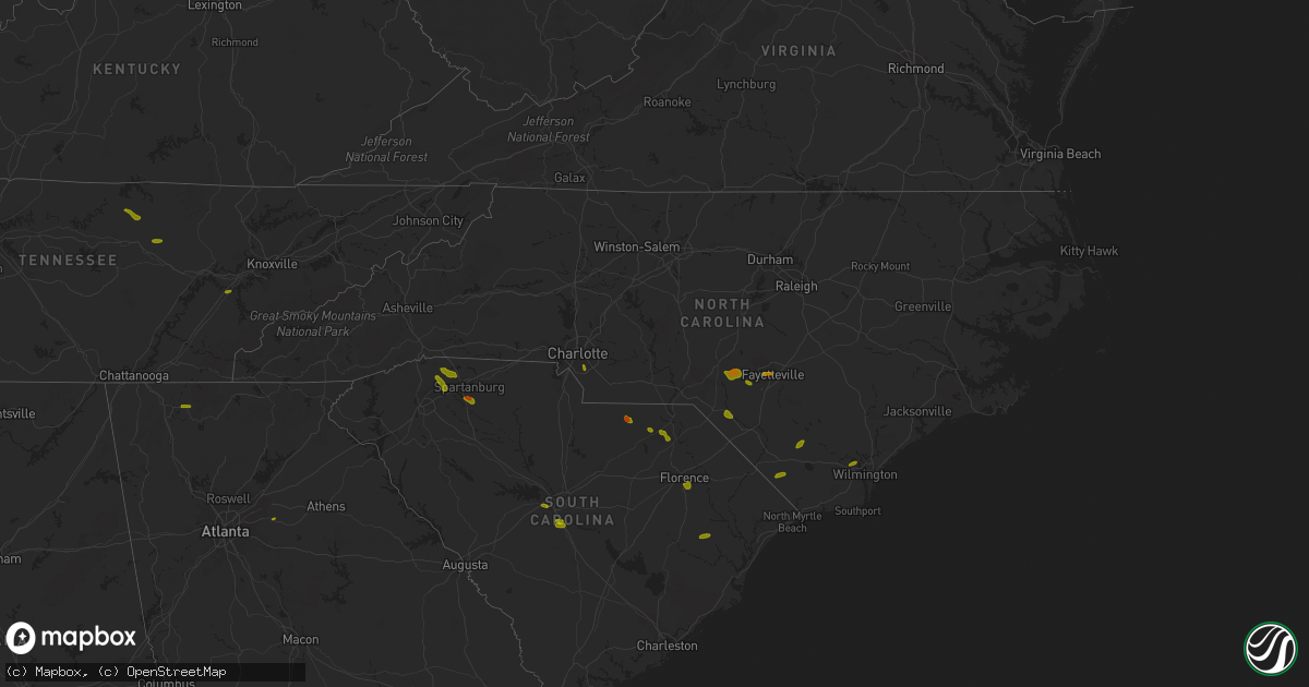
Hail Map in North Carolina on June 25, 2018
Get this storm
June 25 map
$229
one time, instant access
Download today. No call, no setup
Keep the $229
Bought the map and want the full workflow? Apply the entire $229 to a subscription within 7 days. None of it is wasted.
Every map, not just this one
This buys you this map. Subscription and you get every map we run, in the markets you choose from a few cities to whole states to nationwide. Plus real-time alerts the moment a storm fires.
Contact data
Name, contact info, occupancy, even credit band for addresses in the footprint. You go from where it hit to who to call.
Become the source they trust
Unlimited branding weather history reports on demand. You already have the documented answer ready for the property owner, and you are the one who showed up with it.
Property data and RoofTrace estimates
Pull up any address you have got, its value and the exact code rules for that jurisdiction, straight from One Click Code. Then RoofTrace estimates the squares, pitch, and roof value, priced the way you price.
Storm reports in North Carolina
North Carolina
| Date | Description |
|---|---|
| 06/25/20186:40 PM CDT | Thunderstorm winds downed several trees around stanly county... Including a few within the city of albemarle. |
| 06/25/20186:34 PM CDT | One tree fell on a house in denton. |
| 06/25/20186:30 PM CDT | Several large tree limbs blown off. |
| 06/25/20186:28 PM CDT | Trees blown down at stokes ferry rd and river rd. |
| 06/25/20186:20 PM CDT | Trees down blocking poole rd. |
| 06/25/20186:15 PM CDT | One tree fell on a house in lexington. |
| 06/25/20186:10 PM CDT | Officials have received several reports of trees blown down into residences across the county. |
| 06/25/20186:04 PM CDT | One large tree was reported down on meeting house lane... Near clemmons road. |
| 06/25/20185:56 PM CDT | Trees down on st. Matthews church road. |
| 06/25/20185:55 PM CDT | One tree was reported down on conrad road near shallowford road. |
| 06/25/20185:46 PM CDT | Tree blown down on power line. |
| 06/25/20185:24 PM CDT | Report of a tree down along capella road near the closer walk baptist church. Time radar estimated. |
| 06/25/20185:24 PM CDT | Tree down on keaton road. Time radar estimated. |
| 06/25/20185:18 PM CDT | County reports a couple trees blown down on east center avenue. |
| 06/25/20185:18 PM CDT | Tree down on hoots road near watson road. Time radar estimated. |
| 06/25/20185:18 PM CDT | Tree down over hwy 21 near judge road. Time radar estimated. |
| 06/25/20185:15 PM CDT | Tree down on hwy 66 near brown mountain church road. Time radar estimated. |
| 06/25/20185:12 PM CDT | Tree down near george road. Time radar estimated. |
| 06/25/20184:50 PM CDT | A local report indicates 1.00 inch wind near 2 SSE LAURINBURG |
| 06/25/20184:50 PM CDT | Social media reported numerous small trees blown down in the catfish community. Time estimated from radar. |
| 06/25/20184:45 PM CDT | Broadcast media reported several trees down along river bend rd. Time estimated from radar. |
| 06/25/20184:42 PM CDT | Trees down in the catfish area. |
| 06/25/20184:36 PM CDT | Trees blown down along hwy 321. |
| 06/25/20184:30 PM CDT | Reports of trees down on mountain ridge church road. |
| 06/25/20184:30 PM CDT | Tree down on lightning lane. Time radar estimated. |
| 06/25/20184:30 PM CDT | Multiple reports of hail up to the size of ping pong balls. |
| 06/25/20184:20 PM CDT | Reports of widespread trees and power lines down across the county. |
| 06/25/20184:20 PM CDT | 1 large oak tree down at 515 hilltop acre street. Dime sized hail also reported around time of event. |
| 06/25/20184:18 PM CDT | Spotter reports tree down in lawn on arbor grove church road. Police dispatch reports another tree down on same road. Time radar estimated. |
| 06/25/20184:12 PM CDT | County official reports one house detroyed and 2 other homes with major damage due to fallen trees. |
| 06/25/20184:10 PM CDT | Multiple trees were blown down by thunderstorm winds in the level cross area. |
| 06/25/20184:05 PM CDT | Broadcast media reported multiple trees down at mountain grove baptist church on connelly springs rd. Time estimated from radar. |
| 06/25/20184:00 PM CDT | Social media reported numerous trees down with damage to power lines and buildings in the gamewell area. Time estimated from radar. |
| 06/25/20184:00 PM CDT | Amateur radio reported several trees down at the intersection of nc 18 and antioch rd. |
| 06/25/20183:57 PM CDT | Broadcast media reported several trees down at the j iverson riddle center off of enola rd. Time estimated from radar. |
| 06/25/20183:55 PM CDT | Broadcast media reported a tree down on conley rd. At i-40 and a tree down on jamestown rd. Near reep dr. Time estimated from radar. |
| 06/25/20183:50 PM CDT | Broadcast media reported a tree down at 251 lucky strike drive. Time estimated from radar. |
| 06/25/20183:50 PM CDT | Amateur radio reported numerous trees down across miller hill road and dulatown road. Time estimated from radar. |
| 06/25/20183:50 PM CDT | Broadcast media reported widespread damage in morganton along the catawba river. Sanford drive is closed due to damage. Time estimated from radar. |
| 06/25/20183:45 PM CDT | Broadcast media reported a tree down on 2322 ashworth rd. Between us 221 and i-40. Time estimated from radar. |
| 06/25/20183:42 PM CDT | Tree down on old shulls road near highway 105 |
| 06/25/20183:35 PM CDT | One tree was reported down on morganton road. |
| 06/25/20183:35 PM CDT | Media report of ping pong size hail in downtown fayetteville. |
| 06/25/20183:30 PM CDT | Trained spotter reported numerous trees and powerlines down in western burke county with widespread damage. Time estimated from radar. |
| 06/25/20183:24 PM CDT | County reports numerous trees down across the northern part of the county. |
| 06/25/20183:24 PM CDT | Tree down on old shulls road near highway 105. Time radar estimated. |
| 06/25/20183:20 PM CDT | Broadcast media reported a couple of trees down on highway 221 in the northern part of the county including at honeycutt road. |
| 06/25/20183:20 PM CDT | Broadcast media reported a tree down at lake tahoma rd and toms creek rd. |
| 06/25/20183:20 PM CDT | Broadcast media reported a tree down on sugar hill road. |
| 06/25/20183:05 PM CDT | A couple large trees blown down at the county 911 center. |
| 06/25/20182:55 PM CDT | Trees and power lines down. |
| 06/25/20182:45 PM CDT | Hail at least the size of quarters reported at 3600 phillipi church road. |
| 06/25/20182:42 PM CDT | Hoke county 911 relayed info from public of a tree down on a power line 3100 block of pittman gove church road. |
| 06/25/20182:39 PM CDT | A couple trees blown down. Large hail was also reported. |
| 06/25/20182:26 PM CDT | County reports a few trees blown down across the town. |
| 06/25/20182:18 PM CDT | Several trees were reported down. |
| 06/25/20185:08 AM CDT | At 1008 PM EDT, severe thunderstorms were located along a line extending from 9 miles north of Pope AFB to 7 miles east of Raeford to Laurinburg, moving east at 25 mph. HAZARD...60 mph wind gusts and penny size hail. SOURCE...Radar indicated. IMPACT...Expect damage to roofs, siding, and trees. Locations impacted include... Fayetteville, Fort Bragg, Antioch, Pope AFB, Hope Mills, Spring Lake, Eastover, Stedman, Wade and Autryville. |
| 06/25/20183:14 AM CDT | At 813 PM EDT, severe thunderstorms were located along a line extending from near Randleman to near Seagrove to 7 miles southwest of Troy, moving southeast at 30 mph. HAZARD...60 mph wind gusts and nickel size hail. SOURCE...Radar indicated. IMPACT...Expect damage to roofs, siding, and trees. Locations impacted include... Sanford, Southern Pines, Pittsboro, Carthage, Siler City, Pinehurst, Aberdeen, Goldston, Whispering Pines and Pinebluff. |
| 06/25/20182:23 AM CDT | At 722 PM EDT, a severe thunderstorm was located near Long Creek, or 9 miles north of Leland, moving south at 15 mph. HAZARD...60 mph wind gusts and quarter size hail. SOURCE...Radar indicated. IMPACT...Minor hail damage to vehicles is possible. Expect wind damage to trees and power lines. Locations impacted include... Wilmington, Leland, Northwest, Bishop, Hightsville, Wrightsboro, Montague, Wilmington International Airport, Batarora, The Borough, Phoenix, Castle Hayne, Long Creek, Silver Lake, Belville, Navassa, Sandy Creek and New Hanover Regional Medical Center.This includes the following highways... Interstate 140 US Route 74 between mile markers 424 and 434. US Route 17 in Brunswick County between mile markers 39 and 44. |
| 06/25/20182:17 AM CDT | At 716 PM EDT, a line of severe thunderstorms was moving southeast at 40 to 50 mph into the Warning area. HAZARD...60 mph wind gusts. SOURCE...Radar indicated. IMPACT...Expect damage to trees and crops. Locations impacted include... Greensboro, High Point, Asheboro, Albemarle, Randleman, Troy, Badin Lake, North Carolina Zoo, Thomasville and Kernersville. |
| 06/25/20181:43 AM CDT | At 643 PM EDT, severe thunderstorms were located along a line extending from 9 miles northeast of Mocksville to 3 miles northeast of Huntersville, moving east at 30 mph. HAZARD...60 mph wind gusts and quarter size hail. SOURCE...Radar indicated. IMPACT...Minor hail damage to vehicles is expected. Expect wind damage to trees and power lines. Locations impacted include... Huntersville, Kannapolis, Downtown Concord, Salisbury, Mocksville, West Concord, Cornelius, Mooresville, Davidson and China Grove. |
| 06/25/20181:27 AM CDT | At 623 PM EDT, a line of severe thunderstorms was approaching the Triad from the west. The line will be moving into Forsyth and Davidson Counties between 630 and 645 PM. HAZARD...60 mph wind gusts and half dollar size hail. SOURCE...Radar indicated. IMPACT...Expect wind damage to crops and trees. Locations impacted include... Winston-Salem, Lexington, Thomasville, Kernersville, Clemmons, Bermuda Run, Huntsville, Linwood, Lewisville and Walkertown. |
| 06/25/20181:18 AM CDT | At 617 PM EDT, a severe thunderstorm was located over Francisco, moving southeast at 25 mph. HAZARD...60 mph wind gusts. SOURCE...Radar indicated. IMPACT...Expect damage to roofs, siding, and trees. Locations impacted include... Walnut Cove... Danbury... Sandy Ridge... King... and Pine Hall. |
| 06/25/20181:13 AM CDT | At 613 PM EDT, a severe thunderstorm was located near Elizabethtown, moving south at 10 mph. HAZARD...60 mph wind gusts and quarter size hail. SOURCE...Radar indicated. IMPACT...Minor hail damage to vehicles is possible. Expect wind damage to trees and power lines. Locations impacted include... Whiteville, Lake Waccamaw, Carvers, Hallsboro, Lisbon, Abbottsburg, Redbug, Elkton, Emerson, Council, Clarkton, Bolton and Columbus Regional Healthcare System.This includes US Route 74 between mile markers 391 and 412. |
| 06/25/201812:58 AM CDT | At 558 PM EDT, severe thunderstorms were located along a line extending from near Dockery to North Wilkesboro, moving east at 20 mph. HAZARD...60 mph wind gusts and quarter size hail. SOURCE...Radar indicated. IMPACT...Hail damage to vehicles is expected. Expect wind damage to roofs, siding, and trees. Locations impacted include... North Wilkesboro... Elkin... Wilkesboro... Yadkinville... and Jonesville. |
| 06/25/201812:57 AM CDT | At 556 PM EDT, severe thunderstorms were located along a line extending from 3 miles south of Yadkinville to 10 miles southwest of Lincolnton, moving east at 50 mph. HAZARD...60 mph wind gusts and quarter size hail. SOURCE...Radar indicated. IMPACT...Minor hail damage to vehicles is expected. Expect wind damage to trees and power lines. Locations impacted include... Huntersville, Hickory, Statesville, Newton, Lincolnton, Mocksville, Taylorsville, Cornelius, Mooresville and Davidson. |
| 06/25/201812:22 AM CDT | At 521 PM EDT, severe thunderstorms were located along a line extending from 7 miles northeast of Taylorsville to 5 miles north of Forest City, moving east at 30 mph. HAZARD...60 mph wind gusts and quarter size hail. SOURCE...Radar indicated. IMPACT...Minor hail damage to vehicles is expected. Expect wind damage to trees and power lines. Locations impacted include... Hickory, Lenoir, Morganton, Newton, Taylorsville, St. Stephens, Conover, Longview, Sawmills and Granite Falls. |
| 06/25/201812:17 AM CDT | At 517 PM EDT, a severe thunderstorm was located 7 miles north of Laurinburg, moving southeast at 20 mph. HAZARD...60 mph wind gusts and quarter size hail. SOURCE...Radar indicated. IMPACT...Hail damage to vehicles is expected. Expect wind damage to roofs, siding, and trees. Locations impacted include... Laurinburg, Maxton, Wagram, East Laurinburg and Laurel Hill. |
| 06/25/201812:15 AM CDT | At 515 PM EDT, a severe thunderstorm was located over Maxton, or 9 miles southeast of Laurinburg, moving east at 15 mph. HAZARD...60 mph wind gusts and quarter size hail. SOURCE...Radar indicated. IMPACT...Minor hail damage to vehicles is possible. Expect wind damage to trees and power lines. Locations impacted include... Red Springs, Pembroke, Maxton, Buie, Wakulla, Raemon, Purvis, Prospect, Elrod, Mcdonald and Raynham.This includes the following highways... Interstate 74 near mile marker 191, between mile markers 208 and203, and between mile markers 192 and 200. Interstate 95 IN North Carolina between mile markers 8 and 11. |
| 06/25/201812:13 AM CDT | At 512 PM EDT, severe thunderstorms were located along a line extending from 12 miles northwest of Pickens to 7 miles southwest of Walhalla to 6 miles southwest of Toccoa, moving southeast at 30 mph. HAZARD...60 mph wind gusts and quarter size hail. SOURCE...Radar indicated. IMPACT...Minor hail damage to vehicles is expected. Expect wind damage to trees and power lines. Locations impacted include... Clemson, Toccoa, Seneca, Walhalla, Pickens, Clarkesville, Central, Cornelia, Pendleton and Liberty. |
| 06/25/201812:11 AM CDT | At 510 PM EDT, a severe thunderstorm was located near Aberdeen, or 8 miles south of Southern Pines, moving east at 10 mph. HAZARD...60 mph wind gusts and half dollar size hail. SOURCE...Radar indicated. IMPACT...Hail damage to vehicles is expected. Expect wind damage to roofs, siding, and trees. Locations impacted include... Raeford, Fort Bragg, Antioch, Silver City, Rockfish, Bowmore and Ashley Heights. |
| 06/24/201811:59 PM CDT | At 459 PM EDT, severe thunderstorms were located along a line extending from Summit to Elkville, moving east at 25 mph. HAZARD...60 mph wind gusts and quarter size hail. SOURCE...Radar indicated. IMPACT...Hail damage to vehicles is expected. Expect wind damage to roofs, siding, and trees. Locations impacted include... North Wilkesboro... Wilkesboro... Ronda... Boomer... and Wilbar. |
| 06/24/201811:53 PM CDT | At 453 PM EDT, a severe thunderstorm was located over Fairview, moving east at 10 mph. HAZARD...60 mph wind gusts and quarter size hail. SOURCE...Radar indicated. IMPACT...Hail damage to vehicles is expected. Expect wind damage to roofs, siding, and trees. Locations impacted include... Fairview... Dobson... Pilot Mountain... Pilot Mountain State Park... and Level Cross. |
| 06/24/201811:38 PM CDT | At 437 PM EDT, severe thunderstorms were located along a line extending from 5 miles southeast of Deep Gap to 8 miles east of Marion to 15 miles east of Downtown Asheville, moving east at 45 mph. HAZARD...60 mph wind gusts and quarter size hail. SOURCE...Radar indicated. IMPACT...Minor hail damage to vehicles is expected. Expect wind damage to trees and power lines. Locations impacted include... Lenoir, Morganton, Marion, Sawmills, Granite Falls, Valdese, Gamewell, Hudson, Icard and Cajah's Mountain. |
| 06/24/201811:34 PM CDT | At 433 PM EDT, severe thunderstorms were located along a line extending from 6 miles northwest of Clayton to 6 miles east of Dahlonega, moving east at 30 mph. HAZARD...60 mph wind gusts and quarter size hail. SOURCE...Radar indicated. IMPACT...Minor hail damage to vehicles is expected. Expect wind damage to trees and power lines. Locations impacted include... Toccoa, Clayton, Clarkesville, Cornelia, Baldwin, Demorest, Mount Airy, Alto, Mountain City and Tiger. |
| 06/24/201811:23 PM CDT | At 422 PM EDT, a severe thunderstorm was located near Fayetteville, moving east at 25 mph. HAZARD...60 mph wind gusts and half dollar size hail. SOURCE...Radar indicated. IMPACT...Hail damage to vehicles is expected. Expect wind damage to roofs, siding, and trees. Locations impacted include... Fayetteville, Fort Bragg, Hope Mills, Eastover, Stedman, Autryville, Vander, Cedar Creek, Bushy Lake Natural Area and Bonnie Doone. |
| 06/24/201810:53 PM CDT | At 353 PM EDT, severe thunderstorms were located along a line extending from near Richlands to near Bristol Tn, moving east at 30 mph. HAZARD...60 mph wind gusts and penny size hail. SOURCE...Radar indicated. IMPACT...Expect damage to roofs, siding, and trees. Locations impacted include... Bristol Tn, Bristol Va, Abingdon, Lebanon, Mountain City, Walnut Hill, Glade Spring, Honaker, Damascus, Laurel Bloomery, Emory-Meadow View, Rosedale, Shady Valley, South Holston Dam, Dye, Lindell, Holston, Hansonville, Hilander Park and Benhams. |
| 06/24/201810:31 PM CDT | At 331 PM EDT, severe thunderstorms were located along a line extending from 8 miles southwest of Town Of Santeetlah to 6 miles south of Murphy to near Morganton, moving east at 25 mph. HAZARD...60 mph wind gusts and penny size hail. SOURCE...Radar indicated. IMPACT...Expect damage to roofs, siding, and trees. Locations impacted include... Andrews, Murphy, Hayesville, Shooting Creek, Tusquitee, Topton, Brasstown and Marble. |
| 06/24/201810:28 PM CDT | At 328 PM EDT, a severe thunderstorm was located near Raeford, moving east at 20 mph. HAZARD...60 mph wind gusts and quarter size hail. SOURCE...Radar indicated. IMPACT...Hail damage to vehicles is expected. Expect wind damage to roofs, siding, and trees. Locations impacted include... Fayetteville, Raeford, Antioch, Hope Mills, Stedman, Silver City, Cedar Creek, Bushy Lake Natural Area, Rockfish and Bowmore. |
| 06/24/201810:08 PM CDT | At 308 PM EDT, a severe thunderstorm was located 9 miles west of Downtown Asheville, or near Leicester, moving east at 15 mph. HAZARD...60 mph wind gusts and quarter size hail. SOURCE...Radar indicated. IMPACT...Minor hail damage to vehicles is expected. Expect wind damage to trees and power lines. Locations impacted include... Downtown Asheville, East Asheville, West Asheville, North Asheville, Woodfin, Weaverville, Bent Creek, Leicester, UNC Asheville and B.R. Parkway-East Asheville To Craggy Gardens. |
| 06/24/201810:04 PM CDT | At 303 PM EDT, a severe thunderstorm was located 16 miles northwest of Robbinsville, or 10 miles west of Smoky Mountains-Twentymile Creek, moving east at 15 mph. HAZARD...60 mph wind gusts and quarter size hail. SOURCE...Radar indicated. IMPACT...Minor hail damage to vehicles is expected. Expect wind damage to trees and power lines. Locations impacted include... Robbinsville, Town Of Santeetlah, Fontana Lake, Smoky Mountains-Fontana Area, Fontana Village, Lake Santeetlah, Smoky Mountains-Twentymile Creek, Stecoah, Tapoco and Cheoah. |
| 06/24/20189:15 PM CDT | Large limbs down. |
| 06/24/20189:12 PM CDT | Tree down on rockfish road. Time estimated by radar. |
| 06/24/20189:10 PM CDT | Large limbs down near west gate. |
| 06/24/20188:20 PM CDT | Tree down southeast of norman. Time estimated by radar. |
| 06/24/20188:05 PM CDT | Tree down on cartledge creek road. Time estimated by radar. |
| 06/24/20188:00 PM CDT | One tree was reported down at juniper lake road and murdocksville road. |
| 06/24/20187:50 PM CDT | One tree was reported down across bethlehem church road and scotch burying road. |
| 06/24/20187:45 PM CDT | Corrects previous tstm wnd dmg report from 3 se covington. Tree down on cartledge creek road. Time estimated by radar. |
| 06/24/20187:40 PM CDT | One tree was reported down in the road at u.s. Highway 705 and leaman road. |
| 06/24/20187:30 PM CDT | A tree and power lines were reported down along odell road. |
| 06/24/20187:29 PM CDT | One tree was reported down along highway 211 near the moore county line. |
| 06/24/20187:27 PM CDT | One tree was reported down near browns mills road and bascom chapel road. |
| 06/24/20187:20 PM CDT | Tree reported down at dover church road and dan road. |
| 06/24/20187:18 PM CDT | One tree was reported down along u.s. Highway 74 in peachland... Nc. |
| 06/24/20187:08 PM CDT | One tree was reported down on reynolds street near hickory street. |
| 06/24/20187:02 PM CDT | County reports many trees blown down in the waxhaw to mineral springs area. |
| 06/24/20187:01 PM CDT | Tree down across the road. Reported at mack rd and mcdowell rd... Asheboro. |
| 06/24/20187:01 PM CDT | One tree was reported down across racetrack road. |
All States Impacted by Hail Map on June 25, 2018
Cities Impacted by Hail Map on June 25, 2018
- New Florence, MO
- Montgomery City, MO
- Rhineland, MO
- Portland, MO
- Marthasville, MO
- Du Quoin, IL
- Tamaroa, IL
- Pinckneyville, IL
- Mulkeytown, IL
- Sesser, IL
- Benton, IL
- Christopher, IL
- Campobello, SC
- Wellford, SC
- Inman, SC
- Landrum, SC
- Society Hill, SC
- Patrick, SC
- Effingham, SC
- Florence, SC
- Mount Croghan, SC
- Jefferson, SC
- Pageland, SC
- Greer, SC
- Duncan, SC
- Lyman, SC
- Hemingway, SC
- Nesmith, SC
- Kingstree, SC
- Pauline, SC
- Roebuck, SC
- Spartanburg, SC
- Gaston, SC
- Swansea, SC
- West Columbia, SC
- Lexington, SC
- Raeford, NC
- Lumber Bridge, NC
- Fayetteville, NC
- Aberdeen, NC
- Fort Bragg, NC
- Maxton, NC
- Clarkton, NC
- Whiteville, NC
- Chadbourn, NC
- Clarendon, NC
- Tabor City, NC
- Leland, NC
- Charlotte, NC
- Highwood, MT
- Geraldine, MT
- Geyser, MT
- Loudon, TN
- Livingston, TN
- Rickman, TN
- Monterey, TN
- Crossville, TN
- Chatsworth, GA
- Loganville, GA
- Ferguson, NC
- Hope Mills, NC
- Belvidere, TN
- Fitzgerald, GA
- Rhine, GA
- Strafford, MO
- Springfield, MO
- Fair Grove, MO
- Surrency, GA
- Bristol, GA
- Pooler, GA
- Savannah, GA
- Pitts, GA
- Mountain Home, AR
- Oakland, AR
- Philadelphia, TN
- Leicester, NC
- Eastover, SC
- Clarkesville, GA
- Moore, SC
- Lake Waccamaw, NC
- Hallsboro, NC
- Tignall, GA
- Fairmont, NC
- Orrum, NC
- Dobson, NC
- Elkin, NC
- Carlyle, IL
- Midway, AL
- Statesboro, GA
- Hardaway, AL
- Breese, IL
- Bishopville, SC
- Hartsville, SC
- Eva, AL
- Falkville, AL
- Lenoir, NC
- Morganton, NC
- Mullins, SC
- Marion, SC
- East Dublin, GA
- Dublin, GA
- Johnsonville, SC
- Roanoke, AL
- Columbia, IL
- Saluda, NC
- Mill Spring, NC
- Ten Mile, TN
- Lancaster, SC
- Waxhaw, NC
- Fort Mill, SC
- Tuskegee, AL
- Kershaw, SC
- Round O, SC
- Blackstock, SC
- Pembroke, GA
- Scranton, SC
- Timmonsville, SC
- Olanta, SC
- Brooklet, GA
- Burnsville, NC
- Spruce Pine, NC
- Fort Shaw, MT
- Sainte Genevieve, MO
- Harrison, GA
- Davisboro, GA
- Franklin, NC
- Washington, GA
- Carlton, GA
- New Zion, SC
- Hopkins, SC
- Saint Matthews, SC
- North, SC
- Bonne Terre, MO
- Catlin, IL
- Fairmount, IL
- Appling, GA
- Eastman, GA
- Cabool, MO
- Belt, MT
- De Soto, MO
- Valles Mines, MO
- South Greenfield, MO
- Everton, MO
- Green Mountain, NC
- Wallace, SC
- Cheraw, SC
- Chesterfield, SC
- Sunbright, TN
- Science Hill, KY
- Preston, GA
- Richland, GA
- Adrian, GA
- Taylors, SC
- O'Brien, FL
- Branford, FL
- Nicholls, GA
- Lynchburg, SC
- Georgetown, SC
- Richburg, SC
- Grovespring, MO
- Grovetown, GA
- Harlem, GA
- Dayton, TN
- Darlington, SC
- Adams Run, SC
- Power, MT
- Sun River, MT
- Vaughn, MT
- Laurinburg, NC
- Stoutland, MO
- Richland, MO
- Lebanon, MO
- Boaz, AL
- Albertville, AL
- Ash, NC
- Gadsden, SC
- Summerville, SC
- Carrollton, GA
- Marshfield, MO
- Solo, MO
- Mountain Grove, MO
- Woodruff, SC
- Great Falls, SC
- Holly Ridge, NC
- McBee, SC
- Abbeville, GA
- Rochelle, GA
- Cordele, GA
- Arabi, GA
- Whitesburg, GA
- Marissa, IL
- Lenzburg, IL
- New Athens, IL
- Claxton, GA
- Register, GA
- Coulterville, IL
- Lyons, GA
- Collins, GA
- Danville, IL
- Oakwood, IL
- Westville, IL
- Buckner, IL
- Nashville, IL
- Gresham, SC
- Lula, GA
- Wetumpka, AL
- Port Wentworth, GA
- Goose Creek, SC
- Damascus, GA
- Etowah, TN
- La Fayette, GA
- Guntersville, AL
- Keysville, GA
- Louisville, GA
- Waynesboro, GA
- Wrens, GA
- Licking, MO
- Mayesville, SC
- Cascade, MT
- Bennettsville, SC
- Evensville, TN
- Linn, MO
- Bonnots Mill, MO
- Steedman, MO
- Blackwell, MO
- Park Hills, MO
- Irondale, MO
- Festus, MO
- French Village, MO
- Mineral Point, MO
- Cadet, MO
- Belgrade, MO
- Potosi, MO
- Bixby, MO
- Belleview, MO
- Half Way, MO
- Athens, TN
- Riceville, TN
- Ellington, MO
- Somerset, KY
- Bucyrus, MO
- Seymour, TN
- Marion, NC
- Old Fort, NC
- Hickory Grove, SC
- Chester, SC
- Winnsboro, SC
- Dalton, GA
- Anniston, AL
- Jacksonville, AL
- Cottageville, SC
- Heflin, AL
- Fruithurst, AL
- Roswell, GA
- Rome, GA
- Wadley, AL
- Ellaville, GA
- Salem, AL
- Opelika, AL
- Cusseta, AL
- Valley, AL
- Fort Stewart, GA
- Hamilton, GA
- Cataula, GA
- Moultrie, GA
- Pavo, GA
- Houston, TX
- Berlin, GA
- Trenton, IL
- Pocahontas, IL
- Highland, IL
- Aviston, IL
- Crocker, MO
- Vienna, MO
- Newburg, MO
- Keyesport, IL
- Beckemeyer, IL
- Caledonia, MO
- Conway, MO
- Phillipsburg, MO
- Miller, MO
- Walnut Grove, MO
- Lockwood, MO
- Greenfield, MO
- Elkland, MO
- Bolivar, MO
- Bois D Arc, MO
- Mount Vernon, MO
- Republic, MO
- Ash Grove, MO
- Marionville, MO
- Willard, MO
- Brighton, MO
- Pleasant Hope, MO
- Billings, MO
- Halltown, MO
- Buffalo, MO
- Pomona, MO
- West Plains, MO
- Seymour, MO
- Sweetwater, TN
- Niota, TN
- Stanford, KY
- Asheville, NC
- Ruby, SC
- Resaca, GA
- Horton, AL
- Calhoun, GA
- Lamar, SC
- Elizabethtown, NC
- Kingston, GA
- Sumter, SC
- Elliott, SC
- Rockmart, GA
- Coward, SC
- Turbeville, SC
- Islandton, SC
- Oglethorpe, GA
- Ridgeville, SC
- Tyrone, GA
- Union City, GA
- Palmetto, GA
- Douglasville, GA
- Fairburn, GA
- Atlanta, GA
- Green Pond, SC
- Yemassee, SC
- Union Springs, AL
- Fort Davis, AL
- Rincon, GA
- Guyton, GA
- Ashburn, GA
- Casey, IL
- Stotts City, MO
- Sarcoxie, MO
- Pierce City, MO
- Wentworth, MO
- Rolla, MO
- Bismarck, MO
- Farmington, MO
- Koeltztown, MO
- Argyle, MO
- Freeburg, MO
- Boss, MO
- Salem, MO
- Plato, MO
- Henderson, AR
- New Haven, MO
- Edgar Springs, MO
- Graff, MO
- Tellico Plains, TN
- Vonore, TN
- State Road, NC
- Madisonville, TN
- Rutherfordton, NC
- Lake Lure, NC
- Gillsville, GA
- Blenheim, SC
- Gaylesville, AL
- Brookwood, AL
- Andersonville, GA
- Ravenel, SC
- Ladson, SC
- Chamois, MO
- Sparta, IL
- Urbana, IL
- Saint Joseph, IL
- Fenton, MO
- Eureka, MO
- High Ridge, MO
- Black, MO
- Gravel Switch, KY
- Robbins, TN
- Midway, AR
- Gassville, AR
- Flippin, AR
- Hartville, MO
- Mills River, NC
- Horse Shoe, NC
- Travelers Rest, SC
- Sherwood, TN
- Jonesville, SC
- Evergreen, NC
- Ellijay, GA
- Talking Rock, GA
- Valhermoso Springs, AL
- Laceys Spring, AL
- Lumberton, NC
- Lake City, SC
- Gray, GA
- Macon, GA
- Andrews, SC
- Cades, SC
- Auburn, AL
- Tallassee, AL
- Americus, GA
- Reynolds, GA
- Cuthbert, GA
- Odum, GA
- Lenox, GA
- Marianna, FL
- Millwood, GA
- Oakdale, IL
- Dixon, MO
- Jerome, MO
- Long Lane, MO
- Success, MO
- Valdese, NC
- Whitesburg, KY
- Decatur, TN
- Bryant, AL
- Bryson City, NC
- Ranger, GA
- Chickamauga, GA
- Menlo, GA
- Arab, AL
- Sellers, SC
- Buchanan, GA
- Tucker, GA
- Decatur, GA
- Bartow, GA
- Woodland, AL
- Wedowee, AL
- Williston, SC
- Windsor, SC
- Reidsville, GA
- Notasulga, AL
- Eufaula, AL
- Clinton, MO
- Urich, MO
- Iberia, MO
- Clinton, IL
- Foley, MO
- Saint Louis, MO
- Windyville, MO
- Prairie Du Rocher, IL
- Nancy, KY
- Crawford, TN
- Rock Island, TN
- Laurel Hill, NC
- Marston, NC
- Red Springs, NC
- Hamlet, NC
- Pacolet, SC
- Rocky Face, GA
- Rocky Point, NC
- Galivants Ferry, SC
- Ohatchee, AL
- Matthews, GA
- Bowdon, GA
- Jacksonboro, SC
- Walterboro, SC
- Forsyth, GA
- Culloden, GA
- Altha, FL
- Hardeeville, SC
- Plains, GA
- Coolidge, GA
- Tilton, IL
- Augusta, MO
- Vichy, MO
- Red Bud, IL
- Bloomsdale, MO
- Bunker, MO
- Davisville, MO
- Aldrich, MO
- Dadeville, MO
- Annapolis, MO
- Ironton, MO
- Piedmont, MO
- Coeburn, VA
- Parkers Lake, KY
- Elk Creek, MO
- Houston, MO
- Millers Creek, NC
- North Wilkesboro, NC
- Allons, TN
- Hilham, TN
- Taylorsville, NC
- Kingston, TN
- Hoffman, NC
- Wagram, NC
- Fountain Inn, SC
- Simpsonville, SC
- Crandall, GA
- Old Fort, TN
- Heath Springs, SC
- Valley Head, AL
- Mentone, AL
- Sugar Valley, GA
- Bolton, NC
- Gainesville, GA
- Dallas, GA
- Loris, SC
- Acworth, GA
- Columbia, SC
- Orangeburg, SC
- Salley, SC
- Wedgefield, SC
- Manning, SC
- Snellville, GA
- Newnan, GA
- Munford, AL
- Musella, GA
- Grand Ridge, FL
- Loxley, AL
- Georgetown, FL
- Belle, MO
- Westphalia, MO
- Meta, MO
- Steelville, MO
- Knoxville, TN
- Niangua, MO
- Murphy, NC
- Robbinsville, NC
- Tiger, GA
- Pamplico, SC
- Bethune, SC
- Burgaw, NC
- Alcolu, SC
- Tallapoosa, GA
- Weaver, AL
- Covington, GA
- Social Circle, GA
- Pawleys Island, SC
- Hollywood, SC
- Eclectic, AL
- Ideal, GA
- Trenton, FL
- Ochlocknee, GA
- Fitzpatrick, AL
- Buena Vista, GA
- Simms, MT
- West Frankfort, IL
- Mcminnville, TN
- Union Mills, NC
- Ellsinore, MO
- Ocoee, TN
- Marietta, SC
- Cleveland, SC
- Cameron, NC
- Vass, NC
- Wilmington, NC
- Currie, NC
- Fyffe, AL
- Green Sea, SC
- Norcross, GA
- Peachtree Corners, GA
- Wrightsville, GA
- Chester, GA
- Cochran, GA
- Hurtsboro, AL
- Alma, GA
- Cutler, IL
- Scheller, IL
- Monett, MO
- Gibson, NC
- Hendersonville, NC
- Columbus, NC
- Eldridge, MO
- Camdenton, MO
- Tamassee, SC
- Council, NC
- Bladenboro, NC
- Conway, SC
- Huntsville, AL


