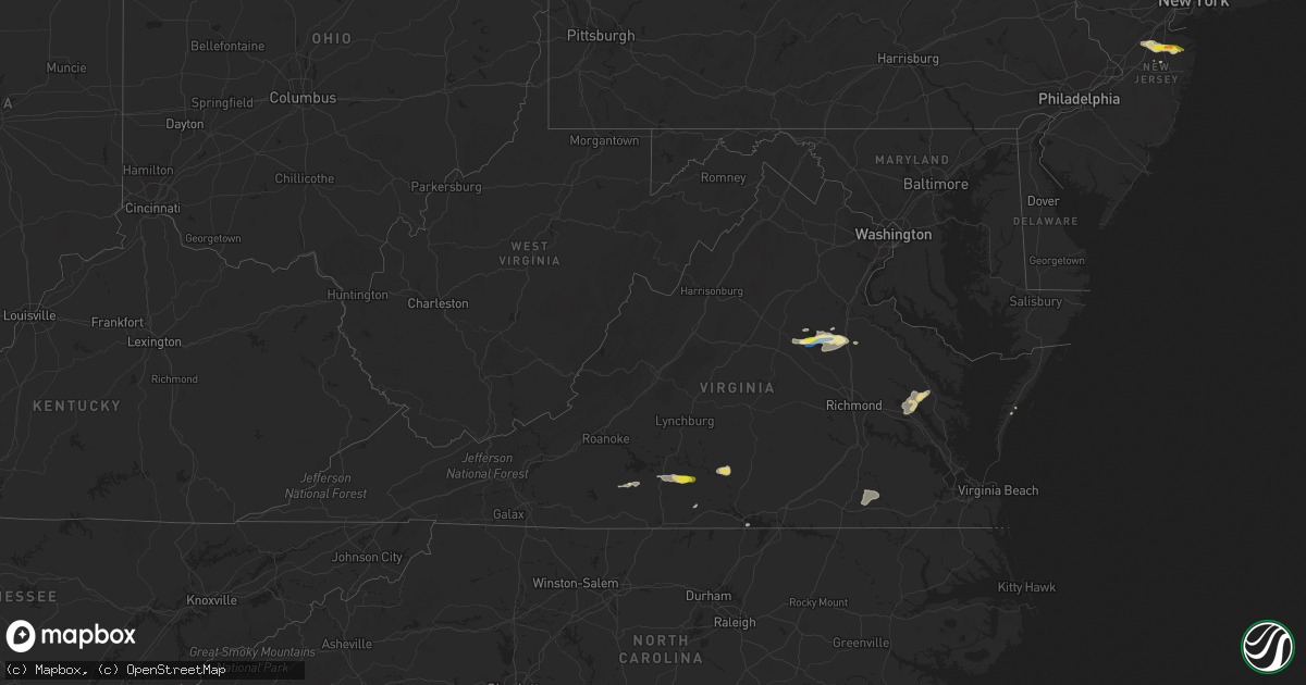
Hail Map in Virginia on June 18, 2019
Get this storm
June 18 map
$229
one time, instant access
Download today. No call, no setup
Keep the $229
Bought the map and want the full workflow? Apply the entire $229 to a subscription within 7 days. None of it is wasted.
Every map, not just this one
This buys you this map. Subscription and you get every map we run, in the markets you choose from a few cities to whole states to nationwide. Plus real-time alerts the moment a storm fires.
Contact data
Name, contact info, occupancy, even credit band for addresses in the footprint. You go from where it hit to who to call.
Become the source they trust
Unlimited branding weather history reports on demand. You already have the documented answer ready for the property owner, and you are the one who showed up with it.
Property data and RoofTrace estimates
Pull up any address you have got, its value and the exact code rules for that jurisdiction, straight from One Click Code. Then RoofTrace estimates the squares, pitch, and roof value, priced the way you price.
Storm reports in Virginia
Virginia
| Date | Description |
|---|---|
| 06/18/20196:20 PM CDT | Roof blown off of a garage. Also... A large amount of tree damage in the same portion of the county. Damage consistent with straight line wind. |
| 06/18/20196:20 PM CDT | Several power poles snapped and a couple trees down. |
| 06/18/20196:10 PM CDT | Tree down on dumfries road near i-95. |
| 06/18/20195:43 PM CDT | Trees and large limbs down. A crab house sustained minor damage. |
| 06/18/20195:38 PM CDT | Power lines and tree down near painter. |
| 06/18/20195:05 PM CDT | Tree down on the 6200 block of old auburn road. |
| 06/18/20194:57 PM CDT | Report of a couple trees down in west point. |
| 06/18/20194:50 PM CDT | Report of numerous trees down. |
| 06/18/20194:40 PM CDT | A media partner passed along a report from a viewer of numerous limbs down within the highlands circle subdivision. Timing estimated by radar. |
| 06/18/20194:40 PM CDT | Large tree limbs up to 8 inches in diameter down in driveway of residence in the 4900 block of blaydes corner road. |
| 06/18/20194:30 PM CDT | Three trees down near the intersection of wallers road and partlow road. |
| 06/18/20194:15 PM CDT | Trees snapped and uprooted along pine harbour drive. Report via social media. |
| 06/18/20194:08 PM CDT | Tree down on chopping rd near louisa high school. |
| 06/18/20193:41 PM CDT | Thunderstorm winds blew down one tree near the intersection of whispering pines road and peach orchard road. |
| 06/18/20193:39 PM CDT | Tree down along george washington highway near union cemetery road. Time estimated from radar. |
| 06/18/20193:33 PM CDT | Large tree down blocking one lane of thomas jefferson highway in the vicinity of cut thru lane. Time estimated from radar. |
| 06/18/20193:17 PM CDT | Thunderstorm winds blew down one tree near the intersection of scuffletown road and harrisburg road. |
| 06/18/20193:17 PM CDT | Thunderstorm winds blew down three trees along the 4500 block of scuffletown road. |
| 06/18/20192:59 PM CDT | Thunderstorm winds blew down one tree on to a car along the 7100 block of howard p. Anderson road. |
| 06/18/20192:55 PM CDT | Corrects previous tstm wnd dmg report from adwolf. A media partner passed along a report from a viewer of numerous limbs down within the highlands circle subdivision. T |
| 06/18/20192:34 PM CDT | Thunderstorm winds blew down one tree on the 7000 block of james d. Hagood highway. |
| 06/18/20192:22 PM CDT | Tree down along swinging bridge road just off of brookneal highway. Time estimated from radar. |
| 06/18/20192:11 PM CDT | Thunderstorm winds blew down one tree near the intersection of us route 29 and sycamore creek road. |
| 06/18/20191:30 PM CDT | Tree down off ramsey memorial rd. Time radar estimated. |
| 06/18/20191:25 AM CDT | At 624 PM EDT, a severe thunderstorm was located over Willis Wharf, or over Exmore, moving northeast at 25 mph. HAZARD...60 mph wind gusts and quarter size hail. SOURCE...Radar indicated. IMPACT...Minor damage to vehicles is possible. Expect wind damage to trees and powerlines. Locations impacted include... Exmore, Onancock, Parksley, Onley, Nassawadox, Willis Wharf, Accomac, Melfa, Wachapreague, Painter, Keller, Jamesville, Wardtown, Franktown, Nelsonia, Locustville, Modest Town, Pungoteague, Tasley and Quinby. |
| 06/18/201912:54 AM CDT | At 554 PM EDT, a severe thunderstorm was located over Warrenton, moving east at 25 mph. HAZARD...60 mph wind gusts and quarter size hail. SOURCE...Radar indicated. IMPACT...Damaging winds will cause some trees and large branches to fall. This could injure those outdoors, as well as damage homes and vehicles. Roadways may become blocked by downed trees. Localized power outages are possible. Unsecured light objects may become projectiles. Locations impacted include... Warrenton, Linton Hall, Haymarket, Gainesville, New Baltimore, Nokesville, Catlett, Catharpin, Broken Hill, Auburn, Greenwich, Turnbull and Airlie. |
| 06/18/201912:47 AM CDT | At 547 PM EDT, a severe thunderstorm was located over Little Plymouth, or near West Point, moving northeast at 30 mph. HAZARD...60 mph wind gusts and quarter size hail. SOURCE...Radar indicated. IMPACT...Minor damage to vehicles is possible. Expect wind damage to trees and powerlines. This severe thunderstorm will be near, Church View, Jamaica and Saluda around 605 PM EDT. Urbanna around 610 PM EDT. Morattico around 620 PM EDT.Other locations impacted by this severe thunderstorm include Nesting,Holly Forks, Eltham, Somers, Mollusk, Senora, Slabtown, Nuttsville,Bertrand and Belle Isle State Park. |
| 06/18/201912:27 AM CDT | At 526 PM EDT, a severe thunderstorm was located 7 miles north of Bumpass, or 11 miles northeast of Mineral, moving east at 30 mph. HAZARD...60 mph wind gusts and quarter size hail. SOURCE...Radar indicated. IMPACT...Minor damage to vehicles is possible. Expect wind damage to trees and powerlines. This severe thunderstorm will be near, Ladysmith around 550 PM EDT. Milford around 605 PM EDT. Bowling Green around 610 PM EDT. Fort A.p. Hill around 615 PM EDT.Other locations impacted by this severe thunderstorm includeChilesburg, Rappahannock Academy, Sparta, Golansville, Villboro,Nancy Wrights Corner, Guinea, Ruther Glen, Woodford and Penola. |
| 06/18/201912:09 AM CDT | At 508 PM EDT, a severe thunderstorm was located over Mineral, moving east at 20 mph. HAZARD...60 mph wind gusts and quarter size hail. SOURCE...Radar indicated. IMPACT...Damaging winds will cause some trees and large branches to fall. This could injure those outdoors, as well as damage homes and vehicles. Roadways may become blocked by downed trees. Localized power outages are possible. Unsecured light objects may become projectiles. Locations impacted include... Glenora, Partlow and Gatewood. |
| 06/17/201911:58 PM CDT | At 458 PM EDT, a severe thunderstorm was located near Mineral, moving east at 25 mph. HAZARD...60 mph wind gusts and quarter size hail. SOURCE...Radar indicated. IMPACT...Minor damage to vehicles is possible. Expect wind damage to trees and powerlines. This severe thunderstorm will be near, Bumpass around 520 PM EDT.Other locations impacted by this severe thunderstorm include WaresCrossroads, Pendleton, Louisa Airport, Fredericks Hall and VawterCorner. |
| 06/17/201911:21 PM CDT | At 420 PM EDT, a severe thunderstorm was located near Charlotte Court House, moving east at 15 mph. HAZARD...60 mph wind gusts and quarter size hail. SOURCE...Radar indicated. IMPACT...Hail damage to vehicles is expected. Expect wind damage to roofs, siding, and trees. Locations impacted include... Keysville... Charlotte Court House... Phenix... Drakes Branch... and Abilene. |
| 06/17/201910:51 PM CDT | At 351 PM EDT, a severe thunderstorm was located over Leda, moving east at 20 mph. HAZARD...Ping pong ball size hail and 60 mph wind gusts. SOURCE...Radar indicated. IMPACT...People and animals outdoors will be injured. Expect hail damage to roofs, siding, windows, and vehicles. Expect wind damage to roofs, siding, and trees. Locations impacted include... Brookneal... Charlotte Court House... Clover... Nathalie... and Mt Laurel. |
| 06/17/201910:02 PM CDT | At 302 PM EDT, a severe thunderstorm was located over Gretna, moving east at 20 mph. HAZARD...60 mph wind gusts. SOURCE...Radar indicated. IMPACT...Expect damage to roofs, siding, and trees. Locations impacted include... Hurt... Gretna... Brookneal... Mt Airy... and Nathalie. |
| 06/17/20199:23 PM CDT | At 223 PM EDT, a severe thunderstorm was located over Sago, moving east at 10 mph. HAZARD...60 mph wind gusts and quarter size hail. SOURCE...Radar indicated. IMPACT...Hail damage to vehicles is expected. Expect wind damage to roofs, siding, and trees. Locations impacted include... Chatham... Penhook... Callands... Sago... and Climax. |
All States Impacted by Hail Map on June 18, 2019
Cities Impacted by Hail Map on June 18, 2019
- Joplin, MT
- Burden, KS
- Post, TX
- Eunice, NM
- Centerville, KS
- Garnett, KS
- Laverne, OK
- Woodward, OK
- Mooreland, OK
- Skellytown, TX
- Borger, TX
- Junction City, KS
- Felt, OK
- Telephone, TX
- Sharon, OK
- Chester, OK
- Wakita, OK
- Fairview, OK
- Erick, OK
- Tishomingo, OK
- Sanderson, TX
- Dryden, TX
- Richmond, KS
- Princeton, KS
- Elk City, KS
- Choctaw, OK
- Newalla, OK
- Mangum, OK
- Atlanta, KS
- Conway Springs, KS
- Courtland, VA
- Yale, VA
- Capron, VA
- Stony Creek, VA
- Gage, OK
- Shattuck, OK
- Okarche, OK
- Butler, OK
- Perryton, TX
- Longview, TX
- Manzanola, CO
- Rocky Ford, CO
- Manchester, OK
- Levelland, TX
- Littlefield, TX
- Anton, TX
- Pampa, TX
- Holly, CO
- Sublette, KS
- Ardmore, OK
- Ashton, ID
- Wellington, KS
- Turon, KS
- Chouteau, OK
- Locust Grove, OK
- Mclean, TX
- Wichita, KS
- Newcastle, TX
- Broken Arrow, OK
- Coweta, OK
- Texola, OK
- Willow, OK
- Sweetwater, OK
- Sayre, OK
- Udall, KS
- Winfield, KS
- Clarendon, TX
- Quail, TX
- Wellington, TX
- Shamrock, TX
- Deer Trail, CO
- Boise City, OK
- Grenville, NM
- Clayton, NM
- Abernathy, TX
- Pittsburg, TX
- Leesburg, TX
- Hamlin, TX
- McCaulley, TX
- Roby, TX
- Belt, MT
- Big Spring, TX
- Panhandle, TX
- Stinnett, TX
- Sunray, TX
- White Deer, TX
- Canon City, CO
- Lawton, OK
- Olney Springs, CO
- Boone, CO
- Fowler, CO
- Catoosa, OK
- Cordell, OK
- Corn, OK
- Colony, OK
- Stafford, KS
- Kingman, KS
- Arlington, KS
- Cunningham, KS
- Foss, OK
- Clinton, OK
- Latham, KS
- Cambridge, KS
- Gracemont, OK
- Havre, MT
- Balmorhea, TX
- Haven, KS
- Sulphur, OK
- Davis, OK
- Muleshoe, TX
- Aurora, CO
- Howard, KS
- Earth, TX
- Sudan, TX
- Medford, OK
- Canyon, TX
- Piedmont, OK
- Fargo, OK
- Fritch, TX
- Groom, TX
- Kevin, MT
- Shelby, MT
- Orange, VA
- Mineral, VA
- Dalhart, TX
- Holmdel, NJ
- Dayton, NJ
- Helmetta, NJ
- Spotswood, NJ
- Monroe Township, NJ
- East Brunswick, NJ
- Colts Neck, NJ
- Morganville, NJ
- Cranbury, NJ
- Monmouth Junction, NJ
- Marlboro, NJ
- Old Bridge, NJ
- Englishtown, NJ
- Bluff City, KS
- Calumet, OK
- Anson, TX
- Abilene, TX
- Saint Anthony, ID
- Rexburg, ID
- Snyder, TX
- Fluvanna, TX
- Crosbyton, TX
- Spur, TX
- Leon, KS
- Augusta, KS
- Hobbs, NM
- Lovington, NM
- Plains, KS
- Roaring Springs, TX
- Floydada, TX
- Hereford, TX
- Hallsville, TX
- Brusett, MT
- Jordan, MT
- Shidler, OK
- Kilgore, TX
- Argonia, KS
- Harper, KS
- Norwich, KS
- Konawa, OK
- Eureka, KS
- El Dorado, KS
- Lockney, TX
- Gretna, VA
- Nathalie, VA
- Java, VA
- Walsenburg, CO
- Elk City, OK
- Hammon, OK
- Canute, OK
- Collinsville, OK
- Skiatook, OK
- Sperry, OK
- Owasso, OK
- Lubbock, TX
- Shallowater, TX
- Wanette, OK
- Wapanucka, OK
- Coleman, OK
- Adrian, TX
- Cheney, KS
- Colorado Springs, CO
- Fountain, CO
- Detroit, TX
- Clarksville, TX
- Kim, CO
- Marathon, TX
- Coalgate, OK
- Clay Center, KS
- Cut Bank, MT
- Hennessey, OK
- Hulbert, OK
- Fort Gibson, OK
- Wagoner, OK
- Paris, TX
- Blossom, TX
- Coahoma, TX
- Bison, OK
- Hydro, OK
- Roswell, NM
- Tatum, TX
- Diana, TX
- Gilmer, TX
- Henderson, TX
- Harleton, TX
- Arapaho, OK
- Pueblo, CO
- Mount Pleasant, TX
- Talco, TX
- Petersburg, TX
- Ralls, TX
- Lorenzo, TX
- Two Dot, MT
- Miami, TX
- Idalou, TX
- Potwin, KS
- Slaton, TX
- Wilson, TX
- Hermleigh, TX
- Decatur, AR
- Woodford, VA
- Ruther Glen, VA
- Altamont, KS
- Carnegie, OK
- Fort Cobb, OK
- Branson, CO
- Picacho, NM
- Otter, MT
- Jetmore, KS
- Burrton, KS
- Halstead, KS
- Sedgwick, KS
- Stratford, TX
- Rose Hill, KS
- Douglass, KS
- Piedmont, KS
- Beulah, CO
- Rye, CO
- Holdenville, OK
- Hennepin, OK
- Tussy, OK
- Ratliff City, OK
- Duncan, OK
- Foster, OK
- Elmore City, OK
- Garden Plain, KS
- Seminole, TX
- Denver City, TX
- Wildorado, TX
- Marietta, OK
- Weatherford, OK
- Sedan, KS
- Cedar Vale, KS
- Mcconnell Afb, KS
- Trinchera, CO
- Trinidad, CO
- Barnsdall, OK
- Burbank, OK
- Pawhuska, OK
- Wynona, OK
- Model, CO
- Kingfisher, OK
- Watonga, OK
- Omega, OK
- Ira, TX
- Andover, KS
- Rock, KS
- Gate, OK
- Ada, OK
- Sasakwa, OK
- Valley Center, KS
- Rotan, TX
- Sweetwater, TX
- Westbrook, TX
- Colorado City, TX
- Sylvester, TX
- Loraine, TX
- Calhan, CO
- Cooper, TX
- Pecos, TX
- Pottsboro, TX
- Newton, KS
- Booker, TX
- Mount Hope, KS
- Alpine, TX
- Sanders, MT
- Clarksville, VA
- Cave Springs, AR
- Gentry, AR
- Springdale, AR
- Siloam Springs, AR
- Bentonville, AR
- Altus, OK
- Blair, OK
- Mountain View, OK
- Gotebo, OK
- Dumas, TX
- Deer Creek, OK
- Nardin, OK
- Blackwell, OK
- Inola, OK
- Hanston, KS
- Spearville, KS
- Vinson, OK
- Gould, OK
- Rush Springs, OK
- Nahunta, GA
- Belle Plaine, KS
- Partlow, VA
- Spotsylvania, VA
- Tahlequah, OK
- Tulsa, OK
- Kaw City, OK
- Claremore, OK
- Crescent, OK
- Wheeler, TX
- Aiken, SC
- Mount Vernon, TX
- Goddard, KS
- Hinton, OK
- Dimmitt, TX
- Nazareth, TX
- Walsh, CO
- Cashion, OK
- Edmond, OK
- Beaverdam, VA
- Louisa, VA
- Bumpass, VA
- Larned, KS
- Kinsley, KS
- Lanexa, VA
- Barhamsville, VA
- Mascot, VA
- West Point, VA
- Shacklefords, VA
- Mattaponi, VA
- Tonkawa, OK
- Billings, OK
- Parker, KS
- Havana, KS
- Paducah, TX
- Longton, KS
- Lexington, OK
- Brookneal, VA
- Randolph, VA
- Charlotte Court House, VA
- Lamesa, TX
- Ponca City, OK
- Red Rock, OK
- Sumner, TX
- Fort Davis, TX
- Tupelo, OK
- Union City, OK
- El Reno, OK
- Clearwater, KS
- Penhook, VA
- Rocky Mount, VA
- Norman, OK
- Maize, KS
- Chinook, MT
- Forsyth, MT
- Riverton, WY
- Espanola, NM
- Hernandez, NM
- Ohkay Owingeh, NM
- Kingston, OK
- Elgin, ND
- Avondale, CO
- Stratford, OK
- Burns, KS
- Minco, OK
- Shawnee, OK
- Byars, OK
- Wayne, OK
- Breckenridge, TX
- Colwich, KS
- Derby, KS
- Rosston, OK
- Great Falls, MT
- Dickens, TX
- Matador, TX
- Clover, VA
- Oklahoma City, OK
- Bethany, OK
- Sugar City, CO
- Cactus, TX
- Vici, OK
- Seiling, OK
- Roxton, TX
- Lake Creek, TX
- Andale, KS
- Ozona, TX
- Dacoma, OK
- Seminole, OK
- Geary, OK
- Brady, MT
- Buffalo, OK
- Meade, KS
- Cyril, OK
- Apache, OK
- New Leipzig, ND
- Plains, TX
- Mcadoo, TX
- Campbell, TX
- Danville, KS
- Dutton, MT
- Aline, OK
- Carmen, OK
- Crowell, TX
- Sherman, TX
- Fort Stockton, TX
- Tecumseh, OK
- Dover, OK
- Little Plymouth, VA
- Church View, VA
- Saluda, VA
- Thomas, OK
- Taloga, OK
- Grenola, KS
- Browns Summit, NC
- Reidsville, NC
- Beaumont, KS
- Murdock, KS
- Viola, KS
- Bentley, KS
- Moline, KS
- Oxford, KS
- Haysville, KS
- Mulvane, KS
- Peck, KS
- Milton, KS
- Big Sandy, TX
- Lookeba, OK
- Bennett, CO
- Oakwood, OK
- Fay, OK
- Okeene, OK
- Waukomis, OK
- Ames, OK
- Brookston, TX
- Arthur City, TX
- Albany, TX
- Las Animas, CO
- Kaufman, TX
- Wynnewood, OK
- Springer, OK
- Durant, OK
- Bokchito, OK
- Earlsboro, OK
- Claude, TX
- Freedom, OK
- Sulphur Bluff, TX
- Elgin, OK
- Fletcher, OK
- Fredonia, KS
- Black Eagle, MT
- Power, MT
- Sand Coulee, MT
- Saltillo, TX
- Cumby, TX
- Texline, TX
- Troy, NC
- New London, NC
- Denton, NC
- Asheboro, NC
- Scroggins, TX
- May, OK
- Pattonville, TX
- Deport, TX
- Neodesha, KS
- Marlow, OK
- Lindsay, OK
- Exmore, VA
- Dallas, TX
- Hutchins, TX
- Mannsville, OK
- Kenefic, OK
- Madill, OK
- Gladewater, TX
- Mountain Park, OK
- Tipton, OK
- Headrick, OK
- Indiahoma, OK
- Snyder, OK
- Chatham, VA
- Bennington, OK
- Lakin, KS
- Odonnell, TX
- Afton, TX
- Mutual, OK
- Anadarko, OK
- Galata, MT
- Fredericksburg, TX
- Binger, OK
- Granite, OK
- Lone Wolf, OK
- Calera, OK
- Mead, OK
- Millstone Township, NJ
- Caddo, OK
- Caney, OK
- Denison, TX
- Midlothian, TX
- Carthage, TX
- Long Branch, TX
- Dike, TX
- Honey Grove, TX
- Bogata, TX
- Fall River, KS
- Purcell, OK
- Cookville, TX
- Florissant, CO
- Independence, KS
- Hollis, OK
- Dewy Rose, GA
- Braman, OK
- Carter, OK
- Rocky, OK
- Hobart, OK
- Arnett, OK
- Pocasset, OK
- Atoka, OK
- Coldwater, KS
- Halifax, VA
- South Boston, VA
- Yukon, OK
- Grandview, TX
- Winona, TX
- Ulysses, KS
- Macomb, OK
- Sylvania, GA
- Conrad, MT
- Peru, KS
- Woodland, NC
- Ahoskie, NC
- Centerton, AR
- Gravette, AR
- Wyandotte, OK
- Windsor, SC
- Stockett, MT
- Follett, TX
- Ore City, TX
- Nassawadox, VA
- Okemah, OK
- Waynoka, OK
- Yoder, CO
- Seagraves, TX
- Ropesville, TX
- Lewis, KS
- Rich Square, NC
- Roxobel, NC
- Scotland Neck, NC
- Wakefield, KS
- Guthrie, OK
- Loving, TX
- Olney, TX
- Omaha, TX
- Freehold, NJ
- Sentinel, OK
- Lone Grove, OK
- Winfield, TX
- Meridian, OK
- Arcadia, OK
- Wolfforth, TX
- Brownfield, TX
- Luray, SC
- Terrell, TX
- Wills Point, TX
- Greenfield, OK
- Pritchett, CO
- Overbrook, OK
- Asher, OK
- Carter, MT
- Floweree, MT
- Newkirk, OK
- Cheyenne, OK
- Trappe, MD
- Hurlock, MD
- Federalsburg, MD
- Preston, MD
- Lincroft, NJ
- Colorado City, CO
- Ninnekah, OK
- Cement, OK
- Fort Sill, OK
- Medicine Park, OK
- Snow, OK
- Nashoba, OK
- Fittstown, OK
- Lamar, OK
- Stuart, OK
- Wardville, OK
- Stringtown, OK
- Clayton, OK
- Roff, OK
- Paoli, OK
- Allen, OK
- Wewoka, OK
- Pauls Valley, OK
- Maud, OK
- Pittsburg, OK
- Mcalester, OK
- Atwood, OK
- Fitzhugh, OK
- Calvin, OK
- Antlers, OK
- Daisy, OK
- Maysville, OK
- Kiowa, OK
- Centrahoma, OK
- Stonewall, OK
- Comanche, OK
- Noble, OK
- Elmer, OK
- Loveland, OK
- Roosevelt, OK
- Grandfield, OK
- Altus Afb, OK
- Duke, OK
- Devol, OK
- Davidson, OK
- Randlett, OK
- Burkburnett, TX
- Olustee, OK
- Wichita Falls, TX
- Temple, OK
- Frederick, OK
- Petrolia, TX
- Byers, TX
- Hollister, OK
- Alma, KS
- Paxico, KS
- Fieldton, TX
- Olton, TX
- Amherst, TX
- Hale Center, TX
- New Deal, TX
- Girard, TX
- Justiceburg, TX
- Seymour, TX
- Avinger, TX
- Lone Star, TX
- Elm Grove, LA
- Marshall, TX
- Haughton, LA
- Shreveport, LA
- Hughes Springs, TX
- Blanchard, LA
- Daingerfield, TX
- Mooringsport, LA
- Mansfield, LA
- Jefferson, TX
- Karnack, TX
- Barksdale Afb, LA
- Linden, TX
- Bossier City, LA
- Frierson, LA
- Vivian, LA
- Greenwood, LA
- White Oak, TX
- Hawkins, TX
- Waskom, TX
- Bridgeville, DE
- Seaford, DE
- Greenwood, DE
- Marfa, TX


