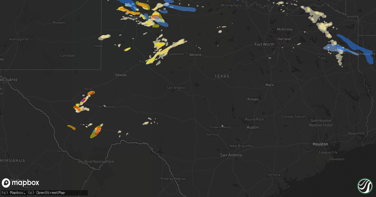
Hail Map in Texas on June 18, 2019
Get this storm
June 18 map
$229
one time, instant access
Download today. No call, no setup
Keep the $229
Bought the map and want the full workflow? Apply the entire $229 to a subscription within 7 days. None of it is wasted.
Every map, not just this one
This buys you this map. Subscription and you get every map we run, in the markets you choose from a few cities to whole states to nationwide. Plus real-time alerts the moment a storm fires.
Contact data
Name, contact info, occupancy, even credit band for addresses in the footprint. You go from where it hit to who to call.
Become the source they trust
Unlimited branding weather history reports on demand. You already have the documented answer ready for the property owner, and you are the one who showed up with it.
Property data and RoofTrace estimates
Pull up any address you have got, its value and the exact code rules for that jurisdiction, straight from One Click Code. Then RoofTrace estimates the squares, pitch, and roof value, priced the way you price.
Storm reports in Texas
Texas
| Date | Description |
|---|---|
| 06/18/20196:55 PM CDT | A local report indicates 1.25 inch wind near 4 WNW CANYON |
| 06/18/20196:54 PM CDT | Quarter sized hail as well as 60 mph winds reported. |
| 06/18/20196:27 PM CDT | Hail less golfball size in the sand springs area along with 60 mph winds. |
| 06/18/20196:25 PM CDT | Hail falling at time of call. |
| 06/18/20196:20 PM CDT | A local report indicates 1.00 inch wind near COAHOMA |
| 06/18/20196:19 PM CDT | A local report indicates 1.75 inch wind near 6 S CONLEN |
| 06/18/20196:08 PM CDT | Late report from area ranchers of dime to a few quarter size hail stones. Time estimated from radar. |
| 06/18/20196:08 PM CDT | A local report indicates 1.75 inch wind near MARATHON |
| 06/18/20196:05 PM CDT | Mix of dime to half dollar sized stones near the post office in marathon. |
| 06/18/20196:04 PM CDT | A local report indicates 60 MPH wind near 5 S MARATHON |
| 06/18/20196:04 PM CDT | A local report indicates 1.00 inch wind near 5 S MARATHON |
| 06/18/20195:53 PM CDT | Late report of half dollar size hail along u.s. Highway 54 near conlen. Time estimated from radar. |
| 06/18/20194:34 PM CDT | Nickel and quarter size hail. |
| 06/18/20194:28 PM CDT | A local report indicates 61 MPH wind near 1 NW FORT STOCKTON |
| 06/18/20194:12 PM CDT | A local report indicates 1.00 inch wind near 5 SW STRATFORD |
| 06/18/20193:35 PM CDT | Lots of quarter and golf ball sized hail mixed. |
| 06/18/20193:07 PM CDT | A local report indicates 1.00 inch wind near 7 S MARFA |
| 06/18/20197:58 AM CDT | At 1258 AM MDT, a severe thunderstorm was located over McDonald, or near Tatum, moving east at 20 mph. HAZARD...Golf ball size hail and 70 mph wind gusts. SOURCE...Radar indicated. IMPACT...People and animals outdoors will be injured. Expect hail damage to roofs, siding, windows, and vehicles. Expect considerable tree damage. Wind damage is also likely to mobile homes, roofs, and outbuildings. Locations impacted include... Tatum, McDonald, Gladiola and Tatum Airport. |
| 06/18/20196:54 AM CDT | At 1153 PM CDT, severe thunderstorms were located along a line extending from near Sentinel to 7 miles northwest of Roosevelt to 5 miles northeast of Gould, moving southeast at 35 mph. HAZARD...60 mph wind gusts and nickel size hail. SOURCE...Radar indicated. IMPACT...Expect damage to roofs, siding, and trees. Locations impacted include... Altus, Frederick, Hobart, Mangum, Cache, Granite, Snyder, Tipton, Blair, Olustee, Lone Wolf, Mountain Park, Medicine Park, Indiahoma, Roosevelt, Gotebo, Manitou, Martha, Elmer and Headrick. |
| 06/18/20196:47 AM CDT | Two transformers damaged... One on fire and one smoking... One 79n just past city limit of carthage... And one cr 30 across from the dcp plant. |
| 06/18/20196:34 AM CDT | Tree down on cr 241 off of fm 124 near beckville. |
| 06/18/20196:30 AM CDT | Tree down hwy 43 toward marshall... 1.5 miles north of tatum city limits. |
| 06/18/20196:15 AM CDT | Tree down causing damage to home on rusk street. |
| 06/18/20196:15 AM CDT | Damage to several signs and billboard hwy 59 and hwy 80 intersection. |
| 06/18/20196:08 AM CDT | Firefighter reports damage to home... Porch ripped off haynes road off hwy 154 nesbitt... Tx just west of marshall. |
| 06/18/20196:07 AM CDT | At 1107 PM CDT, severe thunderstorms were located along a line extending from near Sayre to near Erick to near Wellington, moving east at 35 mph. HAZARD...70 mph wind gusts and quarter size hail. SOURCE...Radar indicated. IMPACT...Expect considerable tree damage. Wind damage is also likely to mobile homes, roofs, and outbuildings. Locations impacted include... Mangum, Hollis, Granite, Erick, Blair, Lone Wolf, Martha, Willow, Gould, Delhi, Vinson, Duke, Warren, Madge, Brinkman, Hester, McQueen, McKnight and Altus-Lugert Lake. |
| 06/18/20196:03 AM CDT | Nws storm survey confirmed and ef-0 tornado. Tornado touched down briefly along highway 450 where it uprooted trees and snapped branches. |
| 06/18/20196:00 AM CDT | Nws storm survery confrimed straight line wind damage. Wind damage included trees uprooted and snapped... As well as roof damage to a barn and carport on a house. Major |
| 06/18/20195:57 AM CDT | At 1056 PM CDT, severe thunderstorms were located along a line extending from 10 miles southeast of Acres to near Buffalo to 10 miles northeast of Follett, moving east at 40 mph. HAZARD...70 mph wind gusts and nickel size hail. SOURCE...Radar indicated. IMPACT...Expect considerable tree damage. Damage is likely to mobile homes, roofs, and outbuildings. Locations impacted include... Woodward, Laverne, Buffalo, Mooreland, Fargo, Fort Supply, Freedom, May, Alabaster Caverns State Park, Selman, Tangier, Catesby and Camp Houston. |
| 06/18/20195:52 AM CDT | Sheriffs office reports trees down county wide. |
| 06/18/20195:45 AM CDT | Large tree down off 729 and 155 south of lone star... Power out in several areas county wide. |
| 06/18/20195:34 AM CDT | Numerous trees were downed across upshur county. |
| 06/18/20195:26 AM CDT | At 1026 PM CDT, severe thunderstorms were located along a line extending from 3 miles south of Swearingen to 7 miles southeast of Chalk to 4 miles north of Guthrie, moving east at 45 mph. HAZARD...70 mph wind gusts and quarter size hail. SOURCE...Radar indicated. IMPACT...Hail damage to vehicles is expected. Expect considerable tree damage. Wind damage is also likely to mobile homes, roofs, and outbuildings. Locations impacted include... Crowell, Benjamin, Margaret, Vera, Thalia, Truscott, Gilliland, Rhineland, Rayland and Copper Breaks State Park. |
| 06/18/20195:13 AM CDT | At 1013 PM CDT, a severe thunderstorm was located near Knowles, or 14 miles east of Beaver, moving east at 55 mph. HAZARD...60 mph wind gusts. SOURCE...Radar indicated. IMPACT...Minor damage to roofs, siding, and trees is possible. Locations impacted include... Gate, Knowles, Elmwood and Slapout. |
| 06/18/20195:05 AM CDT | At 1005 PM CDT, a severe thunderstorm was located 4 miles west of Chalk, or 9 miles south of Paducah, moving east at 40 mph. HAZARD...60 mph wind gusts and quarter size hail. SOURCE...Radar indicated. IMPACT...Hail damage to vehicles is expected. Expect wind damage to roofs, siding, and trees. Locations impacted include... Paducah, Finney, Grow, Chalk and Swearingen. |
| 06/18/20195:02 AM CDT | Trees down and power outages in city of pittsburg and around the county. |
| 06/18/20195:01 AM CDT | At 1001 PM CDT, a severe thunderstorm was located 6 miles north of Clairemont, or 11 miles west of Jayton, moving southeast at 25 mph. HAZARD...60 mph wind gusts and quarter size hail. SOURCE...Radar indicated. IMPACT...Hail damage to vehicles is expected. Expect wind damage to roofs, siding, and trees. Locations impacted include... Jayton, Lake Alan Henry, Girard, Peacock, Justiceburg, Swenson and Clairemont. |
| 06/18/20194:40 AM CDT | At 939 PM CDT, a severe thunderstorm was located 6 miles southwest of Lefors, or 14 miles southeast of Pampa, moving southeast at 30 mph. HAZARD...Two inch hail and 70 mph wind gusts. SOURCE...Radar indicated. IMPACT...Expect some tree damage. Damage is likely to mobile homes, roofs, and outbuildings. People and animals outdoors will be injured. Expect hail damage to roofs, siding, windows, and vehicles. Locations impacted include... Mclean, Lefors, Lela, Alanreed, Lake Mcclellan and Kellerville. |
| 06/18/20194:30 AM CDT | At 930 PM CDT, a severe thunderstorm was located 6 miles east of Matador, moving east at 40 mph. HAZARD...60 mph wind gusts and quarter size hail. SOURCE...Radar indicated. IMPACT...Hail damage to vehicles is expected. Expect wind damage to roofs, siding, and trees. Locations impacted include... Paducah, Matador, Cee Vee, Dumont, Northfield, Delwin, Afton and Roaring Springs. |
| 06/18/20194:12 AM CDT | At 912 PM CDT, a severe thunderstorm was located 4 miles northwest of White River Lake, moving southeast at 25 mph. HAZARD...Ping pong ball size hail and 60 mph wind gusts. SOURCE...Radar indicated. IMPACT...People and animals outdoors will be injured. Expect hail damage to roofs, siding, windows, and vehicles. Expect wind damage to roofs, siding, and trees. Locations impacted include... Crosbyton, Spur, Dickens, White River Lake, Ralls, Kalgary, Caprock and Mcadoo. |
| 06/18/20193:48 AM CDT | At 847 PM CDT, a severe thunderstorm was located 7 miles southwest of Stamford, moving east at 30 mph. HAZARD...60 mph wind gusts and nickel size hail. SOURCE...Radar indicated. IMPACT...Expect damage to roofs, siding, and trees. This severe thunderstorm will be near... Avoca around 910 PM CDT. Lake Stamford Marina around 925 PM CDT. Stamford around 930 PM CDT.Other locations impacted by this severe thunderstorm include Funston,Big Country Baptist Assembly, The Intersection Of Us-180 And Farm Road 600 and Tuxedo. |
| 06/18/20193:44 AM CDT | At 843 PM CDT, a severe thunderstorm was located near Pampa, moving southeast at 20 mph. HAZARD...Ping pong ball size hail and 60 mph wind gusts. SOURCE...Radar indicated. IMPACT...Minor damage to roofs, siding, and trees is possible. People and animals outdoors will be injured. Expect hail damage to roofs, siding, windows, and vehicles. Locations impacted include... Pampa, Mclean, Lefors, New Mobeetie, Lake Mcclellan, Alanreed, Kellerville and Mobeetie. |
| 06/18/20193:42 AM CDT | At 842 PM CDT, a severe thunderstorm was located 4 miles southeast of Borger, moving southeast at 30 mph. This is a very dangerous storm. HAZARD...80 mph wind gusts and baseball size hail. SOURCE...Emergency management. At 837 PM CDT, emergency management reported an 86 mph gust on the southeast side of Borger. IMPACT...People and animals outdoors will be severely injured. Expect shattered windows, extensive damage to roofs, siding, and vehicles. Locations impacted include... Pampa, Borger, Panhandle, White Deer, Skellytown, Kingsmill and Codman. |
| 06/18/20193:29 AM CDT | At 828 PM CDT, a severe thunderstorm was located 4 miles east of Shallowater, or 6 miles north of Lubbock, moving east at 25 mph. HAZARD...Ping pong ball size hail and 60 mph wind gusts. SOURCE...Radar indicated. IMPACT...People and animals outdoors will be injured. Expect hail damage to roofs, siding, windows, and vehicles. Expect wind damage to roofs, siding, and trees. Locations impacted include... Lubbock, Slaton, Wolfforth, Shallowater, Idalou, Ransom Canyon, Lubbock South Plains Mall, Texas Tech University, Lubbock International Airport, Slide, Downtown Lubbock, Woodrow, Reese Center, New Deal, Smyer, Ropesville and Lubbock Science Spectrum. |
| 06/18/20193:19 AM CDT | At 818 PM CDT, a severe thunderstorm was located near Mccaulley, or near Hamlin, moving east at 30 mph. HAZARD...60 mph wind gusts and quarter size hail. SOURCE...Radar indicated. IMPACT...Hail damage to vehicles is expected. Expect wind damage to roofs, siding, and trees. This severe thunderstorm will be near... Neinda around 825 PM CDT. Hamlin around 830 PM CDT.Other locations impacted by this severe thunderstorm include TheIntersection Of Us-180 And Ranch Road 126, Hitson and Tuxedo. |
| 06/18/20193:15 AM CDT | At 814 PM CDT, a severe thunderstorm was located 9 miles southeast of Fluvanna, or 9 miles northwest of Snyder, moving northeast at 25 mph. HAZARD...Ping pong ball size hail and 60 mph wind gusts. SOURCE...Radar indicated. IMPACT...People and animals outdoors will be injured. Expect hail damage to roofs, siding, windows, and vehicles. Expect wind damage to roofs, siding, and trees. Locations impacted include... Snyder, Randalls Corner and Winston Field. |
| 06/18/20193:12 AM CDT | At 812 PM CDT, a severe thunderstorm was located 4 miles southeast of Abernathy, moving east at 35 mph. HAZARD...60 mph wind gusts and quarter size hail. SOURCE...Radar indicated. IMPACT...Hail damage to vehicles is expected. Expect wind damage to roofs, siding, and trees. Locations impacted include... Floydada, Crosbyton, Ralls, Petersburg, Lorenzo and Cone. |
| 06/18/20192:59 AM CDT | At 759 PM CDT, a severe thunderstorm was located 6 miles northwest of Pampa, moving east at 20 mph. HAZARD...60 mph wind gusts and quarter size hail. SOURCE...Radar indicated. IMPACT...Minor damage to roofs, siding, and trees is possible. Hail damage to vehicles is expected. Locations impacted include... Pampa, Skellytown and Codman. |
| 06/18/20192:52 AM CDT | At 751 PM CDT, a severe thunderstorm was located near Roby, or 18 miles north of Sweetwater, moving northeast at 35 mph. HAZARD...60 mph wind gusts and quarter size hail. SOURCE...Radar indicated. IMPACT...Hail damage to vehicles is expected. Expect wind damage to roofs, siding, and trees. This severe thunderstorm will be near... Roby around 800 PM CDT. Sylvester around 815 PM CDT. Mccaulley around 830 PM CDT.Other locations impacted by this severe thunderstorm include Busbyand Capitola. |
| 06/18/20192:46 AM CDT | At 746 PM CDT, severe thunderstorms were located along a line extending from 22 miles southeast of Spearman to 8 miles northwest of Pampa, moving east at 25 mph. HAZARD...Ping pong ball size hail and 60 mph wind gusts. SOURCE...Radar indicated. IMPACT...Minor damage to roofs, siding, and trees is possible. People and animals outdoors will be injured. Expect hail damage to roofs, siding, windows, and vehicles. Locations impacted include... Miami, Codman and Lora. |
| 06/18/20192:41 AM CDT | At 740 PM CDT, a severe thunderstorm was located 5 miles southwest of Palo Duro Canyon, or 10 miles southeast of Canyon, moving east at 20 mph. HAZARD...Ping pong ball size hail and 60 mph wind gusts. SOURCE...Radar indicated. IMPACT...Minor damage to roofs, siding, and trees is possible. People and animals outdoors will be injured. Expect hail damage to roofs, siding, windows, and vehicles. Hail may accumulate on roadways causing hazardous travel. Locations impacted include... Wayside and Palo Duro Canyon. |
| 06/18/20192:36 AM CDT | At 735 PM CDT, a severe thunderstorm was located near Whitharral, or 9 miles south of Littlefield, moving east at 30 mph. HAZARD...Ping pong ball size hail and 60 mph wind gusts. SOURCE...Radar indicated. IMPACT...People and animals outdoors will be injured. Expect hail damage to roofs, siding, windows, and vehicles. Expect wind damage to roofs, siding, and trees. Locations impacted include... Lubbock, Abernathy, Shallowater, Anton, Texas Tech University, Whitharral, Reese Center and New Deal. |
| 06/18/20192:24 AM CDT | At 724 PM CDT, a severe thunderstorm was located near Sunray, or 9 miles northeast of Dumas, moving southeast at 25 mph. HAZARD...Two inch hail and 60 mph wind gusts. SOURCE...Radar indicated. IMPACT...Minor damage to roofs, siding, and trees is possible. People and animals outdoors will be injured. Expect hail damage to roofs, siding, windows, and vehicles. Locations impacted include... Cactus, Sunray, Stinnett, Sanford and Pringle. |
| 06/18/20192:21 AM CDT | At 721 PM CDT, a severe thunderstorm was located near Inadale, or 14 miles northwest of Roscoe, moving northeast at 40 mph. This is a very dangerous storm. HAZARD...80 mph wind gusts and quarter size hail. SOURCE...Radar indicated. IMPACT...Flying debris will be dangerous to those caught without shelter. Mobile homes will be heavily damaged. Expect considerable damage to roofs, windows, and vehicles. Extensive tree damage and power outages are likely. This severe thunderstorm will be near... Hobbs around 740 PM CDT.Other locations impacted by this severe thunderstorm include Gannon,Busby, Capitola, Us-180 Near The Fisher-Scurry County Line and Us-84 Near The Nolan-Fisher County Line. |
| 06/18/20192:20 AM CDT | At 720 PM CDT, a severe thunderstorm was located 10 miles southwest of Lamesa, moving northeast at 40 mph. HAZARD...60 mph wind gusts and quarter size hail. SOURCE...Radar indicated. IMPACT...Hail damage to vehicles is expected. Expect wind damage to roofs, siding, and trees. Locations impacted include... Lamesa, Lamesa Municipal Airport, Los Ybanez, Sparenberg, Tenmile, Patricia, Punkin Center, Arvana, Hancock, Key and Klondike. |
| 06/18/20192:20 AM CDT | At 720 PM MDT, a severe thunderstorm was located near Clayton Lake State Park, or 9 miles north of Clayton, moving east at 20 mph. HAZARD...60 mph wind gusts and half dollar size hail. SOURCE...Radar indicated. IMPACT...Hail damage to vehicles is expected. Expect wind damage to roofs, siding, and trees. Locations impacted include... Clayton, Clayton Lake State Park, Seneca and Moses. |
| 06/18/20192:11 AM CDT | At 711 PM CDT, a severe thunderstorm was located 20 miles northeast of Pandale, or 21 miles southwest of Ozona, moving east at 20 mph. HAZARD...60 mph wind gusts and quarter size hail. SOURCE...Radar indicated. IMPACT...Hail damage to vehicles is expected. Expect wind damage to roofs, siding, and trees. This severe thunderstorm will remain over mainly rural areas of southeastern Crockett County, including the following locations... The Intersection Of Ranch Road 2083 And Highway 405, The Intersection Of Highway 163 And Ranch Road 1973 and I-10 Near The Crockett-Sutton County Line.This includes Interstate 10 near Mile Marker 379. |
| 06/18/20191:54 AM CDT | At 653 PM CDT, a severe thunderstorm was located 12 miles northeast of Coahoma, or 16 miles west of Colorado City, moving northeast at 40 mph. This storm has had a history of producing ping pong ball sized hail. HAZARD...Ping pong ball size hail and 60 mph wind gusts. SOURCE...Radar indicated. IMPACT...People and animals outdoors will be injured. Expect hail damage to roofs, siding, windows, and vehicles. Expect wind damage to roofs, siding, and trees. Locations impacted include... Snyder, Colorado City, Loraine, Colorado City Airport, Lake Colorado City, Lake Colorado City State Park, Inadale, Champion Creek Reservoir, J B Thomas Reservoir, Westbrook, Hermleigh, Randalls Corner, Winston Field, Cuthbert, Knapp, Buford, Dunn and Ira.This includes Interstate 20 between mile markers 203 and 228. |
| 06/18/20191:50 AM CDT | At 650 PM CDT, a severe thunderstorm was located 4 miles north of Umbarger, or 9 miles west of Canyon, moving east at 30 mph. HAZARD...60 mph wind gusts and half dollar size hail. SOURCE...Radar indicated. IMPACT...Minor damage to roofs, siding, and trees is possible. Hail damage to vehicles is expected. Locations impacted include... Amarillo, Canyon, Lake Tanglewood, Mescalero Park, Palo Duro Canyon and Timbercreek Canyon. |
| 06/18/20191:39 AM CDT | At 639 PM CDT, a severe thunderstorm was located 7 miles northwest of Cactus, or 14 miles south of Stratford, moving east at 25 mph. HAZARD...60 mph wind gusts and quarter size hail. SOURCE...Radar indicated. IMPACT...Minor damage to roofs, siding, and trees is possible. Hail damage to vehicles is expected. Locations impacted include... Cactus and Sunray. |
| 06/18/20191:29 AM CDT | At 628 PM CDT, a severe thunderstorm was located 11 miles east of Arch, or 16 miles southwest of Muleshoe, moving east at 30 mph. HAZARD...70 mph wind gusts and ping pong ball size hail. SOURCE...Radar indicated. IMPACT...People and animals outdoors will be injured. Expect hail damage to roofs, siding, windows, and vehicles. Expect considerable tree damage. Wind damage is also likely to mobile homes, roofs, and outbuildings. Locations impacted include... Muleshoe, Olton, Earth, Sudan, Needmore and Springlake. |
| 06/18/20191:07 AM CDT | At 607 AM CDT, a severe thunderstorm was located near De Leon, or 15 miles northwest of Dublin, moving southeast at 50 mph. HAZARD...65 mph wind gusts and quarter size hail. SOURCE...Radar indicated. IMPACT...Hail damage to vehicles is expected. Expect wind damage to roofs, siding, and trees. Locations impacted include... Stephenville, Comanche, Dublin, De Leon, Gorman and Gustine. |
| 06/18/20191:00 AM CDT | At 559 PM CDT, a severe thunderstorm was located near Sand Springs, or near Big Spring, moving northeast at 30 mph. Storm has intensified quickly. HAZARD...60 mph wind gusts and quarter size hail. SOURCE...Radar indicated. IMPACT...Hail damage to vehicles is expected. Expect wind damage to roofs, siding, and trees. Locations impacted include... Big Spring, Coahoma, Forsan, Sand Springs, Colorado City Airport, Luther, Westbrook, Vincent, Cuthbert, Buford, Big Spring Country Club, Big Spring McMahon-Wrinkle Airpark and Elbow.This includes Interstate 20 between mile markers 172 and 210. |
| 06/18/201912:55 AM CDT | At 555 PM CDT, a severe thunderstorm was located over Conlen, or 14 miles southwest of Stratford, moving east at 20 mph. HAZARD...60 mph wind gusts and half dollar size hail. SOURCE...Radar indicated. IMPACT...Minor damage to roofs, siding, and trees is possible. Hail damage to vehicles is expected. Locations impacted include... Cactus and Conlen. |
| 06/18/201912:50 AM CDT | At 550 PM CDT, a severe thunderstorm was located 9 miles east of Simms, or 14 miles northwest of Hereford, moving northeast at 25 mph. HAZARD...Golf ball size hail and 60 mph wind gusts. SOURCE...Radar indicated. IMPACT...Minor damage to roofs, siding, and trees is possible. People and animals outdoors will be injured. Expect hail damage to roofs, siding, windows, and vehicles. Locations impacted include... Wildorado. |
| 06/18/201912:47 AM CDT | At 547 PM CDT, a severe thunderstorm was located 7 miles east of Texhoma, or 17 miles southwest of Guymon, moving northeast at 35 mph. HAZARD...60 mph wind gusts and quarter size hail. SOURCE...Radar indicated. IMPACT...Minor damage to roofs, siding, and trees is possible. Hail damage to vehicles is expected. Locations impacted include... Hardesty. |
| 06/18/201912:35 AM CDT | At 534 PM CDT, a severe thunderstorm was located 18 miles southwest of Marathon, or 32 miles southeast of Alpine, moving north at 35 mph. HAZARD...Ping pong ball size hail and 60 mph wind gusts. SOURCE...Radar indicated. IMPACT...People and animals outdoors will be injured. Expect hail damage to roofs, siding, windows, and vehicles. Expect wind damage to roofs, siding, and trees. Locations impacted include... Marathon and Elephant Mountain Wildlife Management Area. |
| 06/18/201912:13 AM CDT | At 513 PM CDT, a severe thunderstorm was located 12 miles northeast of Ware, or 19 miles north of Dalhart, moving east at 25 mph. HAZARD...60 mph wind gusts and quarter size hail. SOURCE...Radar indicated. IMPACT...Minor damage to roofs, siding, and trees is possible. Hail damage to vehicles is expected. Locations impacted include... Conlen. |
| 06/18/201912:12 AM CDT | At 511 AM CDT, a severe thunderstorm was located near Moran, or 12 miles northwest of Cisco, moving southeast at 30 mph. HAZARD...60 mph wind gusts and penny size hail. SOURCE...Radar indicated. Just before 5 AM...a wind gust to 57 MPH was observed near Clyde. IMPACT...Expect damage to roofs, siding, and trees. Locations impacted include... Eastland, Cisco, Ranger, Gorman, Rising Star, Gunsight and Carbon. This includes Interstate 20 between mile markers 324 and 358. |
| 06/18/201912:05 AM CDT | At 504 AM CDT, a severe thunderstorm was located over Moran, or 14 miles southeast of Albany, moving east at 35 mph. HAZARD...60 mph wind gusts. SOURCE...Radar indicated. IMPACT...Expect damage to roofs, siding, and trees. This severe thunderstorm will remain over mainly rural areas of northeastern Callahan and southeastern Shackelford Counties near Moran and Putnam.This includes Interstate 20 between Mile Markers 312 and 323. |
| 06/17/201911:53 PM CDT | Occurred on highway 83 north of wellington and was ongoing at the time of the call. |
| 06/17/201911:52 PM CDT | At 451 PM CDT, a severe thunderstorm was located 20 miles west of Persimmon Gap, or 26 miles northwest of Panther Junction, moving northeast at 15 mph. HAZARD...Golf ball size hail and 60 mph wind gusts. SOURCE...Radar indicated. IMPACT...People and animals outdoors will be injured. Expect hail damage to roofs, siding, windows, and vehicles. Expect wind damage to roofs, siding, and trees. Locations impacted include... Persimmon Gap, Santiago Peak and Elephant Mountain Wildlife Management Area. |
| 06/17/201911:51 PM CDT | At 451 PM CDT, a severe thunderstorm was located near Glenrio, or 26 miles south of Nara Visa, moving east at 20 mph. HAZARD...60 mph wind gusts and half dollar size hail. SOURCE...Radar indicated. IMPACT...Minor damage to roofs, siding, and trees is possible. Hail damage to vehicles is expected. Locations impacted include... Adrian and Glenrio. |
| 06/17/201911:38 PM CDT | At 438 PM CDT, a severe thunderstorm was located 13 miles west of Conlen, or 15 miles north of Dalhart, moving east at 10 mph. HAZARD...60 mph wind gusts and quarter size hail. SOURCE...Radar indicated. IMPACT...Minor damage to roofs, siding, and trees is possible. Hail damage to vehicles is expected. Locations impacted include... Conlen. |
| 06/17/201911:35 PM CDT | At 434 PM CDT, a severe thunderstorm was located near Fort Stockton, moving east at 25 mph. A 61 mph gust was recorded at Fort Stockton Airport. HAZARD...70 mph wind gusts and quarter size hail. SOURCE...Radar indicated. IMPACT...Hail damage to vehicles is expected. Expect considerable tree damage. Wind damage is also likely to mobile homes, roofs, and outbuildings. Locations impacted include... Fort Stockton, Fort Stockton-Pecos County Airport, Girvin and Firestone Test Track.This includes Interstate 10 between mile markers 248 and 289. |
| 06/17/201911:19 PM CDT | At 419 PM CDT, a severe thunderstorm was located 7 miles northeast of Texline, or 14 miles east of Clayton, moving east at 20 mph. HAZARD...60 mph wind gusts and quarter size hail. SOURCE...Radar indicated. IMPACT...Minor damage to roofs, siding, and trees is possible. Hail damage to vehicles is expected. This severe thunderstorm will remain over mainly rural areas of western Dallam County. |
| 06/17/201911:15 PM CDT | Roof blown off of building... Downing powerlines. |
| 06/17/201911:13 PM CDT | At 412 PM CDT, a severe thunderstorm was located 2 miles north of Chisos Basin, or near Panther Junction, moving northeast at 10 mph. HAZARD...Ping pong ball size hail and 60 mph wind gusts. SOURCE...Radar indicated. IMPACT...People and animals outdoors will be injured. Expect hail damage to roofs, siding, windows, and vehicles. Expect wind damage to roofs, siding, and trees. Locations impacted include... Panther Junction and Big Bend National Park. |
| 06/17/201911:10 PM CDT | At 410 PM CDT, a severe thunderstorm was located 8 miles south of Barstow, or 8 miles southeast of Pecos, moving northeast at 35 mph. HAZARD...Ping pong ball size hail and 60 mph wind gusts. SOURCE...Radar indicated. IMPACT...People and animals outdoors will be injured. Expect hail damage to roofs, siding, windows, and vehicles. Expect wind damage to roofs, siding, and trees. Locations impacted include... Pecos, Monahans, Wink, Thorntonville, Barstow, Pyote, Wickett, Toyah Lake, B F Goodrich Testing Track, Pecos Municipal Airport, Roy Hurd Memorial Airport and Winkler County Airport.This includes Interstate 20 between mile markers 39 and 82. |
| 06/17/201911:06 PM CDT | At 406 PM CDT, a severe thunderstorm was located near Terlingua, or 7 miles east of Lajitas, moving northeast at 30 mph. HAZARD...60 mph wind gusts and half dollar size hail. SOURCE...Radar indicated. IMPACT...Hail damage to vehicles is expected. Expect wind damage to roofs, siding, and trees. Locations impacted include... Terlingua, Study Butte, Terlingua Ranch Airport, Terlingua Ranch Lodge and Barton Warnock Environmental Educational Center. |
| 06/17/201910:39 PM CDT | A local report indicates 1.00 inch wind near DOZIER |
| 06/17/201910:20 PM CDT | A local report indicates 60 MPH wind near GIRARD |
| 06/17/201910:17 PM CDT | A local report indicates 61 MPH wind near 2 SSE HACKBERRY |
| 06/17/201910:13 PM CDT | At 313 AM CDT, a severe thunderstorm was located 7 miles northwest of Seagraves, moving east at 35 mph. HAZARD...Golf ball size hail and 60 mph wind gusts. SOURCE...Radar indicated. IMPACT...People and animals outdoors will be injured. Expect hail damage to roofs, siding, windows, and vehicles. Expect wind damage to roofs, siding, and trees. Locations impacted include... Tokio and Wellman. |
| 06/17/201910:13 PM CDT | At 313 PM CDT, a severe thunderstorm was located near Saragosa, or 18 miles south of Toyah, moving northeast at 20 mph. HAZARD...60 mph wind gusts and half dollar size hail. SOURCE...Radar indicated. IMPACT...Hail damage to vehicles is expected. Expect wind damage to roofs, siding, and trees. Locations impacted include... Pecos, Balmorhea, Balmorhea Lake, Saragosa, Verhalen, Toyah Lake and Pecos Municipal Airport.This includes the following highways... Interstate 10 between mile markers 203 and 221. Interstate 20 between mile markers 36 and 42. |
| 06/17/201910:11 PM CDT | At 311 PM CDT, a severe thunderstorm was located near Marfa, moving east at 15 mph. HAZARD...60 mph wind gusts and half dollar size hail. SOURCE...Radar indicated. IMPACT...Hail damage to vehicles is expected. Expect wind damage to roofs, siding, and trees. Locations impacted include... Alpine, Marfa and Paisano Pass. |
| 06/17/20199:44 PM CDT | A local report indicates 64 MPH wind near 2 NW LAKE MCCLELLAN |
| 06/17/20199:38 PM CDT | A local report indicates 61 MPH wind near 3 N ROARING SPRINGS |
| 06/17/20199:25 PM CDT | Trained spotter reported several power poles down. |
| 06/17/20199:24 PM CDT | Grandview-hopkins abc7 schoolnet site |
| 06/17/20199:22 PM CDT | Lazy h farms schoolnet |
| 06/17/20199:18 PM CDT | At 218 PM CDT, a severe thunderstorm was located 10 miles southwest of Balmorhea State Park, or 18 miles north of Fort Davis, moving northeast at 5 mph. HAZARD...60 mph wind gusts and half dollar size hail. SOURCE...Radar indicated. IMPACT...Hail damage to vehicles is expected. Expect wind damage to roofs, siding, and trees. Locations impacted include... Balmorhea, Balmorhea Lake, Balmorhea State Park, Buffalo Trail Scout Camp, Toyahvale and Star Mountain.This includes Interstate 10 between mile markers 198 and 206. |
| 06/17/20199:15 PM CDT | A local report indicates 63 MPH wind near 6 NW WHITE RIVER LAKE |
| 06/17/20199:14 PM CDT | The stamford mesonet measured a wind gust to 60 mph. |
| 06/17/20199:08 PM CDT | At 208 PM CDT, a severe thunderstorm was located 8 miles west of Marfa, moving northeast at 10 mph. HAZARD...60 mph wind gusts and half dollar size hail. SOURCE...Radar indicated. IMPACT...Hail damage to vehicles is expected. Expect wind damage to roofs, siding, and trees. Locations impacted include... Marfa, Marfa Municipal Airport and Paisano Pass. |
| 06/17/20199:02 PM CDT | A local report indicates 1.75 inch wind near SKELLYTOWN |
| 06/17/20198:56 PM CDT | The anson sheriffs office estimated wind gusts to near 60 mph. |
| 06/17/20198:48 PM CDT | A local report indicates 1.50 inch wind near 6 NNE LUBBOCK |
| 06/17/20198:46 PM CDT | Late report on local broadcast media webpage of 2.25 inch hail on the southeast side of pampa. Time estimated from radar. |
| 06/17/20198:41 PM CDT | Late report of strong wind gusts estimated to be 60 to 65 mph. |
| 06/17/20198:35 PM CDT | A local report indicates 2.00 inch wind near PAMPA |
| 06/17/20198:35 PM CDT | Emergency manager reported roof blown off house and power poles down. |
| 06/17/20198:35 PM CDT | Emergency manager reported davis mesonet wind gusts of 86 mph. |
| 06/17/20198:33 PM CDT | Late report of 3 inch hail in the keiller heights subdivision of borger. Time estimated from radar. |
| 06/17/20198:33 PM CDT | A local report indicates 2.00 inch wind near 2 NE BORGER |
| 06/17/20198:32 PM CDT | Nickel to golfball size hail at time of call. |
| 06/17/20198:30 PM CDT | Late report of trailer flipped at phillips 66 plan northeast of borger. Time estimated from radar. |
| 06/17/20198:30 PM CDT | Picture of hail sent via twitter. |
| 06/17/20198:26 PM CDT | A local report indicates 62 MPH wind near 2 N BORGER |
| 06/17/20198:25 PM CDT | Late report from broadcast media meteorologist of video showing half-dollar to golf ball size hail. Time estimated from radar. |
| 06/17/20198:25 PM CDT | A local report indicates 1.50 inch wind near SHALLOWATER |
| 06/17/20198:22 PM CDT | Loose objects tossed around and small tree branches broken. Quarter size hail. |
| 06/17/20198:22 PM CDT | Loose objects tossed around and small tree branches broken. Quarter size hail. |
| 06/17/20198:22 PM CDT | Hail larger than golf balls falling. |
| 06/17/20198:20 PM CDT | A local report indicates 1.00 inch wind near SHALLOWATER |
| 06/17/20198:19 PM CDT | Late report of golf ball size hail... With time estimated from radar. |
| 06/17/20198:15 PM CDT | A local report indicates 59 MPH wind near 1 WNW FRITCH |
| 06/17/20198:15 PM CDT | Picture of hail sent via social media. |
| 06/17/20198:14 PM CDT | Brief tornado west of pampa near highway 152 reported by several trained spotters. Tornado on the ground less than one minute. Location based on radar. |
| 06/17/20198:10 PM CDT | The fisher county sheriffs office estimated wind gusts between 65 and 70 mph along with pea size hail. |
| 06/17/20198:10 PM CDT | Brief land spout tornado west of pampa near highway 152 reported by several trained spotters. Tornado on the ground for two minutes. |
| 06/17/20198:09 PM CDT | Late report of damage to house roof due to 6 inch tree limbs broken off tree from thunderstorm winds. Time estimated from radar. |
| 06/17/20198:09 PM CDT | Late report of several tree limbs 3 to 6 inches in diameter downed. Time estimated from radar. |
| 06/17/20198:05 PM CDT | A local report indicates 58 MPH wind near 5 ENE ABERNATHY |
| 06/17/20197:45 PM CDT | A local report indicates 1.00 inch wind near 1 WSW ALPINE |
| 06/17/20197:37 PM CDT | Largest hailstone was just over 1.5 inches in length. Most were around a half inch... With some quarter and half dollar size |
| 06/17/20197:27 PM CDT | Twitter photo of quarter to half dollar size hail. |
| 06/17/20197:23 PM CDT | A local report indicates 1.00 inch wind near 1 SE CACTUS |
| 06/17/20197:16 PM CDT | A local report indicates 70 MPH wind near 3 SW HERMLEIGH |
| 06/17/20197:14 PM CDT | A local report indicates 1.75 inch wind near 4 S SNYDER |
| 06/17/20197:07 PM CDT | A local report indicates 1.25 inch wind near 2 WNW CANYON |
| 06/17/20197:05 PM CDT | A local report indicates 1.75 inch wind near IRA |
| 06/17/20197:01 PM CDT | A local report indicates 1.50 inch wind near 2 N CACTUS |
| 06/17/20197:01 PM CDT | Late report from facebook of quarter size hail north of canyon. Time estimated from radar. |
All States Impacted by Hail Map on June 18, 2019
Cities Impacted by Hail Map on June 18, 2019
- Joplin, MT
- Burden, KS
- Post, TX
- Eunice, NM
- Centerville, KS
- Garnett, KS
- Laverne, OK
- Woodward, OK
- Mooreland, OK
- Skellytown, TX
- Borger, TX
- Junction City, KS
- Felt, OK
- Telephone, TX
- Sharon, OK
- Chester, OK
- Wakita, OK
- Fairview, OK
- Erick, OK
- Tishomingo, OK
- Sanderson, TX
- Dryden, TX
- Richmond, KS
- Princeton, KS
- Elk City, KS
- Choctaw, OK
- Newalla, OK
- Mangum, OK
- Atlanta, KS
- Conway Springs, KS
- Courtland, VA
- Yale, VA
- Capron, VA
- Stony Creek, VA
- Gage, OK
- Shattuck, OK
- Okarche, OK
- Butler, OK
- Perryton, TX
- Longview, TX
- Manzanola, CO
- Rocky Ford, CO
- Manchester, OK
- Levelland, TX
- Littlefield, TX
- Anton, TX
- Pampa, TX
- Holly, CO
- Sublette, KS
- Ardmore, OK
- Ashton, ID
- Wellington, KS
- Turon, KS
- Chouteau, OK
- Locust Grove, OK
- Mclean, TX
- Wichita, KS
- Newcastle, TX
- Broken Arrow, OK
- Coweta, OK
- Texola, OK
- Willow, OK
- Sweetwater, OK
- Sayre, OK
- Udall, KS
- Winfield, KS
- Clarendon, TX
- Quail, TX
- Wellington, TX
- Shamrock, TX
- Deer Trail, CO
- Boise City, OK
- Grenville, NM
- Clayton, NM
- Abernathy, TX
- Pittsburg, TX
- Leesburg, TX
- Hamlin, TX
- McCaulley, TX
- Roby, TX
- Belt, MT
- Big Spring, TX
- Panhandle, TX
- Stinnett, TX
- Sunray, TX
- White Deer, TX
- Canon City, CO
- Lawton, OK
- Olney Springs, CO
- Boone, CO
- Fowler, CO
- Catoosa, OK
- Cordell, OK
- Corn, OK
- Colony, OK
- Stafford, KS
- Kingman, KS
- Arlington, KS
- Cunningham, KS
- Foss, OK
- Clinton, OK
- Latham, KS
- Cambridge, KS
- Gracemont, OK
- Havre, MT
- Balmorhea, TX
- Haven, KS
- Sulphur, OK
- Davis, OK
- Muleshoe, TX
- Aurora, CO
- Howard, KS
- Earth, TX
- Sudan, TX
- Medford, OK
- Canyon, TX
- Piedmont, OK
- Fargo, OK
- Fritch, TX
- Groom, TX
- Kevin, MT
- Shelby, MT
- Orange, VA
- Mineral, VA
- Dalhart, TX
- Holmdel, NJ
- Dayton, NJ
- Helmetta, NJ
- Spotswood, NJ
- Monroe Township, NJ
- East Brunswick, NJ
- Colts Neck, NJ
- Morganville, NJ
- Cranbury, NJ
- Monmouth Junction, NJ
- Marlboro, NJ
- Old Bridge, NJ
- Englishtown, NJ
- Bluff City, KS
- Calumet, OK
- Anson, TX
- Abilene, TX
- Saint Anthony, ID
- Rexburg, ID
- Snyder, TX
- Fluvanna, TX
- Crosbyton, TX
- Spur, TX
- Leon, KS
- Augusta, KS
- Hobbs, NM
- Lovington, NM
- Plains, KS
- Roaring Springs, TX
- Floydada, TX
- Hereford, TX
- Hallsville, TX
- Brusett, MT
- Jordan, MT
- Shidler, OK
- Kilgore, TX
- Argonia, KS
- Harper, KS
- Norwich, KS
- Konawa, OK
- Eureka, KS
- El Dorado, KS
- Lockney, TX
- Gretna, VA
- Nathalie, VA
- Java, VA
- Walsenburg, CO
- Elk City, OK
- Hammon, OK
- Canute, OK
- Collinsville, OK
- Skiatook, OK
- Sperry, OK
- Owasso, OK
- Lubbock, TX
- Shallowater, TX
- Wanette, OK
- Wapanucka, OK
- Coleman, OK
- Adrian, TX
- Cheney, KS
- Colorado Springs, CO
- Fountain, CO
- Detroit, TX
- Clarksville, TX
- Kim, CO
- Marathon, TX
- Coalgate, OK
- Clay Center, KS
- Cut Bank, MT
- Hennessey, OK
- Hulbert, OK
- Fort Gibson, OK
- Wagoner, OK
- Paris, TX
- Blossom, TX
- Coahoma, TX
- Bison, OK
- Hydro, OK
- Roswell, NM
- Tatum, TX
- Diana, TX
- Gilmer, TX
- Henderson, TX
- Harleton, TX
- Arapaho, OK
- Pueblo, CO
- Mount Pleasant, TX
- Talco, TX
- Petersburg, TX
- Ralls, TX
- Lorenzo, TX
- Two Dot, MT
- Miami, TX
- Idalou, TX
- Potwin, KS
- Slaton, TX
- Wilson, TX
- Hermleigh, TX
- Decatur, AR
- Woodford, VA
- Ruther Glen, VA
- Altamont, KS
- Carnegie, OK
- Fort Cobb, OK
- Branson, CO
- Picacho, NM
- Otter, MT
- Jetmore, KS
- Burrton, KS
- Halstead, KS
- Sedgwick, KS
- Stratford, TX
- Rose Hill, KS
- Douglass, KS
- Piedmont, KS
- Beulah, CO
- Rye, CO
- Holdenville, OK
- Hennepin, OK
- Tussy, OK
- Ratliff City, OK
- Duncan, OK
- Foster, OK
- Elmore City, OK
- Garden Plain, KS
- Seminole, TX
- Denver City, TX
- Wildorado, TX
- Marietta, OK
- Weatherford, OK
- Sedan, KS
- Cedar Vale, KS
- Mcconnell Afb, KS
- Trinchera, CO
- Trinidad, CO
- Barnsdall, OK
- Burbank, OK
- Pawhuska, OK
- Wynona, OK
- Model, CO
- Kingfisher, OK
- Watonga, OK
- Omega, OK
- Ira, TX
- Andover, KS
- Rock, KS
- Gate, OK
- Ada, OK
- Sasakwa, OK
- Valley Center, KS
- Rotan, TX
- Sweetwater, TX
- Westbrook, TX
- Colorado City, TX
- Sylvester, TX
- Loraine, TX
- Calhan, CO
- Cooper, TX
- Pecos, TX
- Pottsboro, TX
- Newton, KS
- Booker, TX
- Mount Hope, KS
- Alpine, TX
- Sanders, MT
- Clarksville, VA
- Cave Springs, AR
- Gentry, AR
- Springdale, AR
- Siloam Springs, AR
- Bentonville, AR
- Altus, OK
- Blair, OK
- Mountain View, OK
- Gotebo, OK
- Dumas, TX
- Deer Creek, OK
- Nardin, OK
- Blackwell, OK
- Inola, OK
- Hanston, KS
- Spearville, KS
- Vinson, OK
- Gould, OK
- Rush Springs, OK
- Nahunta, GA
- Belle Plaine, KS
- Partlow, VA
- Spotsylvania, VA
- Tahlequah, OK
- Tulsa, OK
- Kaw City, OK
- Claremore, OK
- Crescent, OK
- Wheeler, TX
- Aiken, SC
- Mount Vernon, TX
- Goddard, KS
- Hinton, OK
- Dimmitt, TX
- Nazareth, TX
- Walsh, CO
- Cashion, OK
- Edmond, OK
- Beaverdam, VA
- Louisa, VA
- Bumpass, VA
- Larned, KS
- Kinsley, KS
- Lanexa, VA
- Barhamsville, VA
- Mascot, VA
- West Point, VA
- Shacklefords, VA
- Mattaponi, VA
- Tonkawa, OK
- Billings, OK
- Parker, KS
- Havana, KS
- Paducah, TX
- Longton, KS
- Lexington, OK
- Brookneal, VA
- Randolph, VA
- Charlotte Court House, VA
- Lamesa, TX
- Ponca City, OK
- Red Rock, OK
- Sumner, TX
- Fort Davis, TX
- Tupelo, OK
- Union City, OK
- El Reno, OK
- Clearwater, KS
- Penhook, VA
- Rocky Mount, VA
- Norman, OK
- Maize, KS
- Chinook, MT
- Forsyth, MT
- Riverton, WY
- Espanola, NM
- Hernandez, NM
- Ohkay Owingeh, NM
- Kingston, OK
- Elgin, ND
- Avondale, CO
- Stratford, OK
- Burns, KS
- Minco, OK
- Shawnee, OK
- Byars, OK
- Wayne, OK
- Breckenridge, TX
- Colwich, KS
- Derby, KS
- Rosston, OK
- Great Falls, MT
- Dickens, TX
- Matador, TX
- Clover, VA
- Oklahoma City, OK
- Bethany, OK
- Sugar City, CO
- Cactus, TX
- Vici, OK
- Seiling, OK
- Roxton, TX
- Lake Creek, TX
- Andale, KS
- Ozona, TX
- Dacoma, OK
- Seminole, OK
- Geary, OK
- Brady, MT
- Buffalo, OK
- Meade, KS
- Cyril, OK
- Apache, OK
- New Leipzig, ND
- Plains, TX
- Mcadoo, TX
- Campbell, TX
- Danville, KS
- Dutton, MT
- Aline, OK
- Carmen, OK
- Crowell, TX
- Sherman, TX
- Fort Stockton, TX
- Tecumseh, OK
- Dover, OK
- Little Plymouth, VA
- Church View, VA
- Saluda, VA
- Thomas, OK
- Taloga, OK
- Grenola, KS
- Browns Summit, NC
- Reidsville, NC
- Beaumont, KS
- Murdock, KS
- Viola, KS
- Bentley, KS
- Moline, KS
- Oxford, KS
- Haysville, KS
- Mulvane, KS
- Peck, KS
- Milton, KS
- Big Sandy, TX
- Lookeba, OK
- Bennett, CO
- Oakwood, OK
- Fay, OK
- Okeene, OK
- Waukomis, OK
- Ames, OK
- Brookston, TX
- Arthur City, TX
- Albany, TX
- Las Animas, CO
- Kaufman, TX
- Wynnewood, OK
- Springer, OK
- Durant, OK
- Bokchito, OK
- Earlsboro, OK
- Claude, TX
- Freedom, OK
- Sulphur Bluff, TX
- Elgin, OK
- Fletcher, OK
- Fredonia, KS
- Black Eagle, MT
- Power, MT
- Sand Coulee, MT
- Saltillo, TX
- Cumby, TX
- Texline, TX
- Troy, NC
- New London, NC
- Denton, NC
- Asheboro, NC
- Scroggins, TX
- May, OK
- Pattonville, TX
- Deport, TX
- Neodesha, KS
- Marlow, OK
- Lindsay, OK
- Exmore, VA
- Dallas, TX
- Hutchins, TX
- Mannsville, OK
- Kenefic, OK
- Madill, OK
- Gladewater, TX
- Mountain Park, OK
- Tipton, OK
- Headrick, OK
- Indiahoma, OK
- Snyder, OK
- Chatham, VA
- Bennington, OK
- Lakin, KS
- Odonnell, TX
- Afton, TX
- Mutual, OK
- Anadarko, OK
- Galata, MT
- Fredericksburg, TX
- Binger, OK
- Granite, OK
- Lone Wolf, OK
- Calera, OK
- Mead, OK
- Millstone Township, NJ
- Caddo, OK
- Caney, OK
- Denison, TX
- Midlothian, TX
- Carthage, TX
- Long Branch, TX
- Dike, TX
- Honey Grove, TX
- Bogata, TX
- Fall River, KS
- Purcell, OK
- Cookville, TX
- Florissant, CO
- Independence, KS
- Hollis, OK
- Dewy Rose, GA
- Braman, OK
- Carter, OK
- Rocky, OK
- Hobart, OK
- Arnett, OK
- Pocasset, OK
- Atoka, OK
- Coldwater, KS
- Halifax, VA
- South Boston, VA
- Yukon, OK
- Grandview, TX
- Winona, TX
- Ulysses, KS
- Macomb, OK
- Sylvania, GA
- Conrad, MT
- Peru, KS
- Woodland, NC
- Ahoskie, NC
- Centerton, AR
- Gravette, AR
- Wyandotte, OK
- Windsor, SC
- Stockett, MT
- Follett, TX
- Ore City, TX
- Nassawadox, VA
- Okemah, OK
- Waynoka, OK
- Yoder, CO
- Seagraves, TX
- Ropesville, TX
- Lewis, KS
- Rich Square, NC
- Roxobel, NC
- Scotland Neck, NC
- Wakefield, KS
- Guthrie, OK
- Loving, TX
- Olney, TX
- Omaha, TX
- Freehold, NJ
- Sentinel, OK
- Lone Grove, OK
- Winfield, TX
- Meridian, OK
- Arcadia, OK
- Wolfforth, TX
- Brownfield, TX
- Luray, SC
- Terrell, TX
- Wills Point, TX
- Greenfield, OK
- Pritchett, CO
- Overbrook, OK
- Asher, OK
- Carter, MT
- Floweree, MT
- Newkirk, OK
- Cheyenne, OK
- Trappe, MD
- Hurlock, MD
- Federalsburg, MD
- Preston, MD
- Lincroft, NJ
- Colorado City, CO
- Ninnekah, OK
- Cement, OK
- Fort Sill, OK
- Medicine Park, OK
- Snow, OK
- Nashoba, OK
- Fittstown, OK
- Lamar, OK
- Stuart, OK
- Wardville, OK
- Stringtown, OK
- Clayton, OK
- Roff, OK
- Paoli, OK
- Allen, OK
- Wewoka, OK
- Pauls Valley, OK
- Maud, OK
- Pittsburg, OK
- Mcalester, OK
- Atwood, OK
- Fitzhugh, OK
- Calvin, OK
- Antlers, OK
- Daisy, OK
- Maysville, OK
- Kiowa, OK
- Centrahoma, OK
- Stonewall, OK
- Comanche, OK
- Noble, OK
- Elmer, OK
- Loveland, OK
- Roosevelt, OK
- Grandfield, OK
- Altus Afb, OK
- Duke, OK
- Devol, OK
- Davidson, OK
- Randlett, OK
- Burkburnett, TX
- Olustee, OK
- Wichita Falls, TX
- Temple, OK
- Frederick, OK
- Petrolia, TX
- Byers, TX
- Hollister, OK
- Alma, KS
- Paxico, KS
- Fieldton, TX
- Olton, TX
- Amherst, TX
- Hale Center, TX
- New Deal, TX
- Girard, TX
- Justiceburg, TX
- Seymour, TX
- Avinger, TX
- Lone Star, TX
- Elm Grove, LA
- Marshall, TX
- Haughton, LA
- Shreveport, LA
- Hughes Springs, TX
- Blanchard, LA
- Daingerfield, TX
- Mooringsport, LA
- Mansfield, LA
- Jefferson, TX
- Karnack, TX
- Barksdale Afb, LA
- Linden, TX
- Bossier City, LA
- Frierson, LA
- Vivian, LA
- Greenwood, LA
- White Oak, TX
- Hawkins, TX
- Waskom, TX
- Bridgeville, DE
- Seaford, DE
- Greenwood, DE
- Marfa, TX


