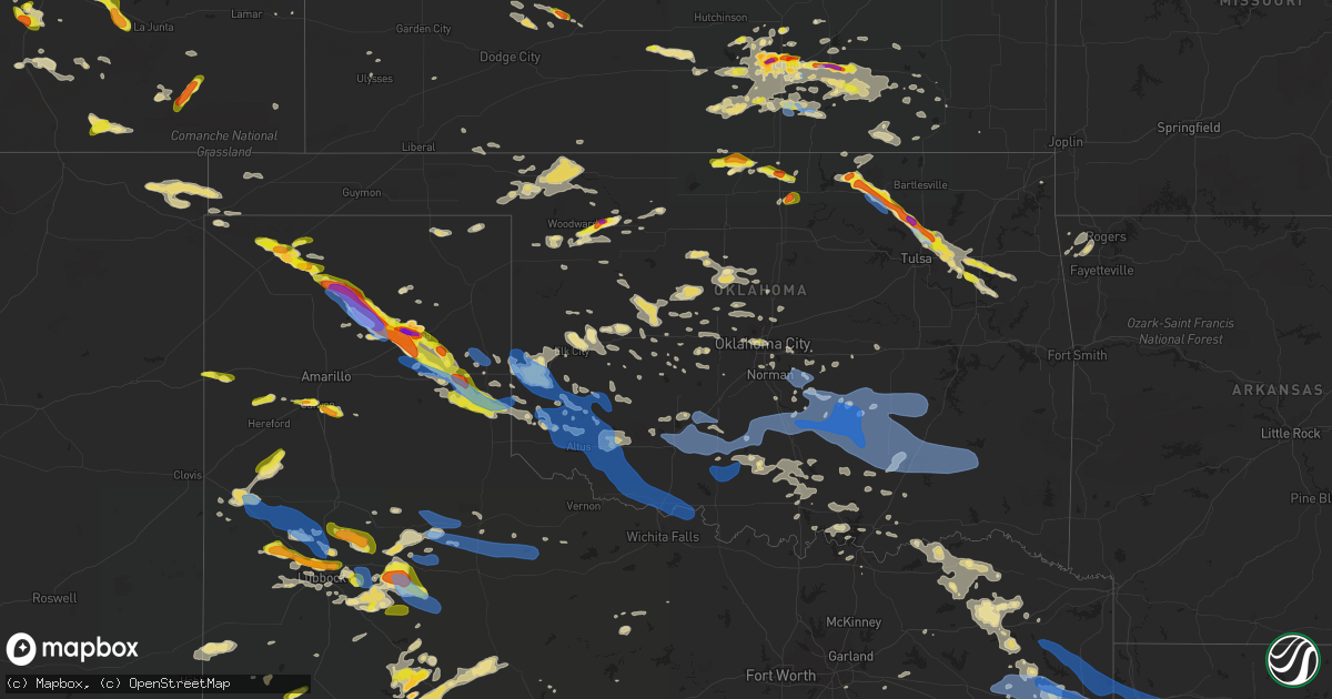
Hail Map in Oklahoma on June 18, 2019
Get this storm
June 18 map
$229
one time, instant access
Download today. No call, no setup
Keep the $229
Bought the map and want the full workflow? Apply the entire $229 to a subscription within 7 days. None of it is wasted.
Every map, not just this one
This buys you this map. Subscription and you get every map we run, in the markets you choose from a few cities to whole states to nationwide. Plus real-time alerts the moment a storm fires.
Contact data
Name, contact info, occupancy, even credit band for addresses in the footprint. You go from where it hit to who to call.
Become the source they trust
Unlimited branding weather history reports on demand. You already have the documented answer ready for the property owner, and you are the one who showed up with it.
Property data and RoofTrace estimates
Pull up any address you have got, its value and the exact code rules for that jurisdiction, straight from One Click Code. Then RoofTrace estimates the squares, pitch, and roof value, priced the way you price.
Storm reports in Oklahoma
Oklahoma
| Date | Description |
|---|---|
| 06/18/20195:58 PM CDT | A local report indicates 1.00 inch wind near BLACKWELL |
| 06/18/20196:58 AM CDT | At 1157 PM CDT, a severe thunderstorm was located near Wagoner. A second severe thunderstorm was located 5 miles south of Peggs. Both thunderstorms were moving southeast at 25 mph. HAZARD...Half dollar size hail. SOURCE...Radar indicated. IMPACT...Damage to vehicles is expected. Locations in or near the path include... Muskogee... Tahlequah... Wagoner... Fort Gibson... Okay... Hulbert... Tullahassee... Eldon... Proctor... Christie... Peggs... Cookson... Cherokee Landing State Park... Scraper... Sequoyah State Park... Lost City... |
| 06/18/20196:40 AM CDT | At 1140 PM CDT, a severe thunderstorm was located 5 miles northeast of Quail, or 9 miles northwest of Wellington, moving east at 30 mph. HAZARD...Tennis ball size hail and 60 mph wind gusts. SOURCE...Radar indicated. IMPACT...Minor damage to roofs, siding, and trees is possible. People and animals outdoors will be injured. Expect hail damage to roofs, siding, windows, and vehicles. Locations impacted include... Wellington, Quail and Lutie. |
| 06/18/20196:33 AM CDT | At 1133 PM CDT, a severe thunderstorm was located 8 miles southwest of Loyal, moving southeast at 25 mph. HAZARD...60 mph wind gusts and quarter size hail. SOURCE...Radar indicated. IMPACT...Hail damage to vehicles is expected. Expect wind damage to roofs, siding, and trees. Locations impacted include... Kingfisher, Piedmont, Okarche, Cashion, Loyal and Omega. |
| 06/18/20196:11 AM CDT | At 1111 PM CDT, a severe thunderstorm was located 5 miles southwest of Chouteau. A second severe thunderstorm was located 5 miles west of Inola. Both of these storms were moving east at 25 mph HAZARD...60 mph wind gusts and half dollar size hail. SOURCE...Radar indicated. IMPACT...Hail damage to vehicles is expected. Expect wind damage to roofs, siding, and trees. Locations in or near the path include... Broken Arrow... Claremore... Wagoner... Chouteau... Inola... Locust Grove... Okay... Hulbert... Peggs... Sequoyah State Park... Taiwah... Tiawah... Sportsmen Acres Community... Mazie... Lost City... Murphy...This includes Interstate 44 between mile markers 242 and 249. |
| 06/18/20195:55 AM CDT | At 1055 PM CDT, a severe thunderstorm was located 5 miles southwest of Samnorwood, or 12 miles northwest of Wellington, moving southeast at 20 mph. HAZARD...Golf ball size hail and 70 mph wind gusts. SOURCE...Radar indicated. IMPACT...Expect some tree damage. Damage is likely to mobile homes, roofs, and outbuildings. People and animals outdoors will be injured. Expect hail damage to roofs, siding, windows, and vehicles. Locations impacted include... Wellington, Dodson, Dozier, Lutie, Quail and Samnorwood. |
| 06/18/20195:49 AM CDT | At 1049 PM CDT, severe thunderstorms were located along a line extending from 4 miles north of Texola to 7 miles southwest of Hammon, moving southeast at 20 mph. HAZARD...60 mph wind gusts and nickel size hail. SOURCE...Radar indicated. IMPACT...Expect damage to roofs, siding, and trees. Locations impacted include... Elk City, Sayre, Burns Flat, Erick, Hammon, Dill City, Canute, Carter, Foss, Texola, Retrop, Delhi, Foss Reservoir and Berlin. |
| 06/18/20195:41 AM CDT | At 1040 PM CDT, a severe thunderstorm was located 5 miles southeast of Verdigris, moving southeast at 20 mph. HAZARD...Golf ball size hail and 60 mph wind gusts. SOURCE...Radar indicated. IMPACT...People and animals outdoors will be injured. Expect hail damage to roofs, siding, windows, and vehicles. Expect wind damage to roofs, siding, and trees. Locations in or near the path include... Chouteau... Inola...This includes Interstate 44 between mile markers 240 and 244. |
| 06/18/20195:28 AM CDT | At 1028 PM CDT, a severe thunderstorm was located 4 miles south of Ames, moving east at 25 mph. HAZARD...60 mph wind gusts and quarter size hail. SOURCE...Radar indicated. IMPACT...Hail damage to vehicles is expected. Expect wind damage to roofs, siding, and trees. Locations impacted include... Enid, Hennessey, Waukomis, Drummond, Ames, Vance Air Force Base, Bison and Lacey. |
| 06/18/20195:15 AM CDT | At 1015 PM CDT, a severe thunderstorm was located near Mclean, or 16 miles west of Shamrock, moving southeast at 40 mph. HAZARD...70 mph wind gusts and ping pong ball size hail. SOURCE...Radar indicated. IMPACT...Expect some tree damage. Damage is likely to mobile homes, roofs, and outbuildings. People and animals outdoors will be injured. Expect hail damage to roofs, siding, windows, and vehicles. Locations impacted include... Wellington, Shamrock, Wheeler, Mclean, Lutie, Twitty, Dozier, Lela, Samnorwood and Kellerville. |
| 06/18/20195:12 AM CDT | At 1012 PM CDT, a severe thunderstorm was located near Skiatook, moving southeast at 25 mph. HAZARD...60 mph wind gusts and half dollar size hail. SOURCE...Radar indicated. IMPACT...Hail damage to vehicles is expected. Expect wind damage to roofs, siding, and trees. Locations in or near the path include... Tulsa... Owasso... Skiatook... Catoosa... Collinsville... Sperry... Turley... |
| 06/18/20195:06 AM CDT | At 1006 PM CDT, a severe thunderstorm was located near Quinlan, moving east at 30 mph. HAZARD...Ping pong ball size hail. SOURCE...Trained weather spotters. IMPACT...People and animals outdoors will be injured. Expect damage to roofs, siding, windows, and vehicles. Locations impacted include... Waynoka, Dacoma, Quinlan, Bouse Junction and Hopeton. |
| 06/18/20195:06 AM CDT | At 1006 PM CDT, a severe thunderstorm was located 4 miles east of Owasso, moving southeast at 25 mph. HAZARD...Golf ball size hail and 60 mph wind gusts. SOURCE...Radar indicated. IMPACT...People and animals outdoors will be injured. Expect hail damage to roofs, siding, windows, and vehicles. Expect wind damage to roofs, siding, and trees. Locations in or near the path include... Claremore... Owasso... Catoosa... Verdigris... Inola... Taiwah... Tiawah... This includes Interstate 44 between mile markers 234 and 251. |
| 06/18/20194:35 AM CDT | At 935 PM CDT, a severe thunderstorm was located 5 miles northeast of Sharon, moving east at 15 mph. HAZARD...Ping pong ball size hail. SOURCE...Radar indicated. IMPACT...People and animals outdoors will be injured. Expect damage to roofs, siding, windows, and vehicles. Locations impacted include... Woodward, Mooreland, Sharon and Quinlan. |
| 06/18/20194:31 AM CDT | At 931 PM CDT, a severe thunderstorm was located over Skiatook, moving southeast at 25 mph. HAZARD...Golf ball size hail and 60 mph wind gusts. SOURCE...Radar indicated. IMPACT...People and animals outdoors will be injured. Expect hail damage to roofs, siding, windows, and vehicles. Expect wind damage to roofs, siding, and trees. Locations in or near the path include... Tulsa... Claremore... Owasso... Skiatook... Catoosa... Collinsville... Sperry... Vera... Turley... Tulsa International Airport...This includes Interstate 44 between mile markers 229 and 232. |
| 06/18/20194:20 AM CDT | Tree limb down. Reported via social media. |
| 06/18/20194:01 AM CDT | At 901 PM CDT, a severe thunderstorm was located 6 miles south of Barnsdall, moving southeast at 25 mph. HAZARD...Golf ball size hail and 60 mph wind gusts. SOURCE...Radar indicated. IMPACT...People and animals outdoors will be injured. Expect hail damage to roofs, siding, windows, and vehicles. Expect wind damage to roofs, siding, and trees. Locations in or near the path include... Skiatook... Barnsdall... Avant... Wolco... |
| 06/18/20193:10 AM CDT | At 810 PM CDT, a severe thunderstorm was located 6 miles south of Pearsonia, moving east at 25 mph. HAZARD...Golf ball size hail and 70 mph wind gusts. SOURCE...Radar indicated. IMPACT...People and animals outdoors will be injured. Expect hail damage to roofs, siding, windows, and vehicles. Expect considerable tree damage. Wind damage is also likely to mobile homes, roofs, and outbuildings. Locations in or near the path include... Pawhuska... Barnsdall... Wynona... Osage Hills State Park... Okesa... Pershing... Nelagoney... Tallant... |
| 06/18/20192:45 AM CDT | Powerlines downed. Time estimated by radar. |
| 06/18/20192:30 AM CDT | A local report indicates 58 MPH wind near 6 SW FITTSTOWN |
| 06/18/20192:26 AM CDT | At 725 PM CDT, a severe thunderstorm was located near Shidler, moving east at 20 mph. HAZARD...60 mph wind gusts and quarter size hail. SOURCE...Radar indicated. IMPACT...Hail damage to vehicles is expected. Expect wind damage to roofs, siding, and trees. Locations in or near the path include... Pawhuska... Shidler... Burbank... Foraker... Pearsonia... Webb City... Apperson... |
| 06/18/20192:21 AM CDT | Roof blown off structure. |
| 06/18/20192:20 AM CDT | Also reported power flashes. |
| 06/18/20192:20 AM CDT | Shed destroyed... Part of home roof missing... Power lines down. |
| 06/18/20192:20 AM CDT | Large tree knocked down by wind. |
| 06/18/20192:20 AM CDT | Display 4 foot by 5 foot outbuilding outside home depot blown upside down. Eight inch tree snapped. |
| 06/18/20192:20 AM CDT | Roof blown off home at 4101 co rd 1560. Time estimated from radar. |
| 06/18/20192:20 AM CDT | Road blocked by downed trees. |
| 06/18/20192:20 AM CDT | Roof damage. Time estimated by radar. |
| 06/18/20192:19 AM CDT | Twitter report. Mobile home significantly damaged near union hill. Time is radar estimate. |
| 06/18/20192:15 AM CDT | A local report indicates 69 MPH wind near 3 ESE BYARS |
| 06/18/20192:15 AM CDT | A local report indicates 62 MPH wind near 4 NNE SULPHUR |
| 06/18/20192:15 AM CDT | Roof blown off house. Time estimated by radar. |
| 06/18/20192:13 AM CDT | Tree limbs through home window. |
| 06/18/20192:13 AM CDT | Trees in power lines and power poles snapped. 9th and park ave. |
| 06/18/20192:13 AM CDT | Power pole snapped. |
| 06/18/20192:13 AM CDT | Power pole snapped. |
| 06/18/20192:10 AM CDT | Numerous tree limbs and small trees downed by wind. |
| 06/18/20192:10 AM CDT | Roof damage of unknown extent. Time estimated by radar. |
| 06/18/20192:00 AM CDT | Barn rolled up into adjacent pasture. Large limbs downed. Patio furniture thrown about. |
| 06/18/20191:55 AM CDT | Winds remained gusty to 62 mph through 2am. |
| 06/18/20191:45 AM CDT | Numerous large trees down. Store front windows blown out. Large steel power poles bent. |
| 06/18/20191:45 AM CDT | Reports of five semi trucks overturned between mile markers 67 and 74 on i-35 near pauls valley. |
| 06/18/20191:42 AM CDT | Several large trees uprooted and power lines downed. Time estimate from radar. |
| 06/18/20191:35 AM CDT | Sheet metal torn off the side of a building. Time estimate from radar. |
| 06/18/20191:25 AM CDT | Corrects previous tstm wnd gst report from 7 nw velma. |
| 06/18/20191:20 AM CDT | A local report indicates 60 MPH wind near ACME |
| 06/18/20191:20 AM CDT | A local report indicates 63 MPH wind near 7 NW VELMA |
| 06/18/20191:05 AM CDT | A local report indicates 66 MPH wind near 4 NW WALTERS |
| 06/18/20191:05 AM CDT | Facebook report. Numerous tree tops snapped and power outages. |
| 06/18/20191:00 AM CDT | Cwop station fw2394 lawton. |
| 06/18/201912:57 AM CDT | At 556 PM CDT, a severe thunderstorm was located near Blackwell, moving east at 25 mph. HAZARD...Two inch hail and 60 mph wind gusts. SOURCE...Radar indicated. IMPACT...People and animals outdoors will be injured. Expect hail damage to roofs, siding, windows, and vehicles. Expect wind damage to roofs, siding, and trees. Locations impacted include... Ponca City, Blackwell, Kaw City, Kildare and Kaw Lake. |
| 06/18/201912:50 AM CDT | A local report indicates 64 MPH wind near 3 W GRANDFIELD |
| 06/18/201912:45 AM CDT | Several large tree branches downed along i-44 and wedged into fencing along side of the road. Time estimate from radar. |
| 06/18/201912:40 AM CDT | A local report indicates 62 MPH wind near 3 W MEDICINE PARK |
| 06/18/201912:34 AM CDT | A local report indicates 61 MPH wind near 3 SE FREDERICK |
| 06/18/201912:30 AM CDT | A local report indicates 60 MPH wind near 4 S TIPTON |
| 06/18/201912:14 AM CDT | At 514 PM CDT, a severe thunderstorm was located 4 miles northeast of Deer Creek, moving east at 15 mph. HAZARD...Ping pong ball size hail and 60 mph wind gusts. SOURCE...Radar indicated. IMPACT...People and animals outdoors will be injured. Expect hail damage to roofs, siding, windows, and vehicles. Expect wind damage to roofs, siding, and trees. Locations impacted include... Blackwell, Braman, Deer Creek, Nardin, Blackwell Lake and Peckham. |
| 06/18/201912:08 AM CDT | A local report indicates 66 MPH wind near ALTUS AIR FORCE BASE |
| 06/17/201911:54 PM CDT | At 454 PM CDT, a severe thunderstorm was located 5 miles southeast of Tonkawa, moving northeast at 15 mph. HAZARD...Ping pong ball size hail and 60 mph wind gusts. SOURCE...Radar indicated. IMPACT...People and animals outdoors will be injured. Expect hail damage to roofs, siding, windows, and vehicles. Expect wind damage to roofs, siding, and trees. Locations impacted include... Ponca City, Tonkawa, Marland, Kildare and southwestern Kaw Lake. |
| 06/17/201911:16 PM CDT | At 415 PM CDT, a severe thunderstorm was located 5 miles south of Stratford, moving east at 25 mph. HAZARD...60 mph wind gusts and quarter size hail. SOURCE...Trained weather spotters. At 412 PM CDT, storm chasers reported quarter size hail on the southwest side of Stratford. IMPACT...Minor damage to roofs, siding, and trees is possible. Hail damage to vehicles is expected. Locations impacted include... Stratford. |
| 06/17/201911:16 PM CDT | A local report indicates 1.00 inch wind near MAZIE |
| 06/17/201910:32 PM CDT | 1-inch tree limbs broken and shingles blown off roof. |
| 06/17/201910:09 PM CDT | Time estimated from radar. Several large limbs down in neighborhood of 81st and 161st. Reported via social media |
| 06/17/201910:07 PM CDT | 12 trees uprooted or snapped at the base in centennial park confirmed with pictures on social media. Time is estimated from radar. |
| 06/17/201910:07 PM CDT | A local report indicates 1.00 inch wind near COLLINSVILLE |
| 06/17/201910:05 PM CDT | A local report indicates 64 MPH wind near 1 SSW BEAVER |
| 06/17/201910:04 PM CDT | Quarter hail reported at 96th street north and highway 169. |
| 06/17/201910:04 PM CDT | A local report indicates 1.50 inch wind near QUINLAN |
| 06/17/201910:03 PM CDT | A local report indicates 1.50 inch wind near 2 NNE OWASSO |
| 06/17/20199:56 PM CDT | Quarter to ping pong ball hail at 126th north and garnett |
| 06/17/20199:55 PM CDT | Quarter hail reported at 116th street north and highway 169. |
| 06/17/20199:53 PM CDT | Thunderstorm winds peeled outer metal skin off mobile home door. Report received via social media. |
| 06/17/20199:52 PM CDT | 65 mph gust at 96th street north in owasso |
| 06/17/20199:51 PM CDT | A local report indicates 1.50 inch wind near 3 SW COLLINSVILLE |
| 06/17/20199:49 PM CDT | A local report indicates 1.00 inch wind near 2 S COLLINSVILLE |
| 06/17/20199:48 PM CDT | Tree approximately 12 inches in diameter blown down |
| 06/17/20199:45 PM CDT | A local report indicates 1.00 inch wind near COLLINSVILLE |
| 06/17/20199:39 PM CDT | A local report indicates 1.00 inch wind near SKIATOOK |
| 06/17/20199:30 PM CDT | A local report indicates 71 MPH wind near SKIATOOK |
| 06/17/20198:37 PM CDT | A local report indicates 1.75 inch wind near 3 N WYNONA |
| 06/17/20198:24 PM CDT | Several large tree branches down. |
| 06/17/20197:42 PM CDT | Golf ball hail on the north side of shidler. |
All States Impacted by Hail Map on June 18, 2019
Cities Impacted by Hail Map on June 18, 2019
- Joplin, MT
- Burden, KS
- Post, TX
- Eunice, NM
- Centerville, KS
- Garnett, KS
- Laverne, OK
- Woodward, OK
- Mooreland, OK
- Skellytown, TX
- Borger, TX
- Junction City, KS
- Felt, OK
- Telephone, TX
- Sharon, OK
- Chester, OK
- Wakita, OK
- Fairview, OK
- Erick, OK
- Tishomingo, OK
- Sanderson, TX
- Dryden, TX
- Richmond, KS
- Princeton, KS
- Elk City, KS
- Choctaw, OK
- Newalla, OK
- Mangum, OK
- Atlanta, KS
- Conway Springs, KS
- Courtland, VA
- Yale, VA
- Capron, VA
- Stony Creek, VA
- Gage, OK
- Shattuck, OK
- Okarche, OK
- Butler, OK
- Perryton, TX
- Longview, TX
- Manzanola, CO
- Rocky Ford, CO
- Manchester, OK
- Levelland, TX
- Littlefield, TX
- Anton, TX
- Pampa, TX
- Holly, CO
- Sublette, KS
- Ardmore, OK
- Ashton, ID
- Wellington, KS
- Turon, KS
- Chouteau, OK
- Locust Grove, OK
- Mclean, TX
- Wichita, KS
- Newcastle, TX
- Broken Arrow, OK
- Coweta, OK
- Texola, OK
- Willow, OK
- Sweetwater, OK
- Sayre, OK
- Udall, KS
- Winfield, KS
- Clarendon, TX
- Quail, TX
- Wellington, TX
- Shamrock, TX
- Deer Trail, CO
- Boise City, OK
- Grenville, NM
- Clayton, NM
- Abernathy, TX
- Pittsburg, TX
- Leesburg, TX
- Hamlin, TX
- McCaulley, TX
- Roby, TX
- Belt, MT
- Big Spring, TX
- Panhandle, TX
- Stinnett, TX
- Sunray, TX
- White Deer, TX
- Canon City, CO
- Lawton, OK
- Olney Springs, CO
- Boone, CO
- Fowler, CO
- Catoosa, OK
- Cordell, OK
- Corn, OK
- Colony, OK
- Stafford, KS
- Kingman, KS
- Arlington, KS
- Cunningham, KS
- Foss, OK
- Clinton, OK
- Latham, KS
- Cambridge, KS
- Gracemont, OK
- Havre, MT
- Balmorhea, TX
- Haven, KS
- Sulphur, OK
- Davis, OK
- Muleshoe, TX
- Aurora, CO
- Howard, KS
- Earth, TX
- Sudan, TX
- Medford, OK
- Canyon, TX
- Piedmont, OK
- Fargo, OK
- Fritch, TX
- Groom, TX
- Kevin, MT
- Shelby, MT
- Orange, VA
- Mineral, VA
- Dalhart, TX
- Holmdel, NJ
- Dayton, NJ
- Helmetta, NJ
- Spotswood, NJ
- Monroe Township, NJ
- East Brunswick, NJ
- Colts Neck, NJ
- Morganville, NJ
- Cranbury, NJ
- Monmouth Junction, NJ
- Marlboro, NJ
- Old Bridge, NJ
- Englishtown, NJ
- Bluff City, KS
- Calumet, OK
- Anson, TX
- Abilene, TX
- Saint Anthony, ID
- Rexburg, ID
- Snyder, TX
- Fluvanna, TX
- Crosbyton, TX
- Spur, TX
- Leon, KS
- Augusta, KS
- Hobbs, NM
- Lovington, NM
- Plains, KS
- Roaring Springs, TX
- Floydada, TX
- Hereford, TX
- Hallsville, TX
- Brusett, MT
- Jordan, MT
- Shidler, OK
- Kilgore, TX
- Argonia, KS
- Harper, KS
- Norwich, KS
- Konawa, OK
- Eureka, KS
- El Dorado, KS
- Lockney, TX
- Gretna, VA
- Nathalie, VA
- Java, VA
- Walsenburg, CO
- Elk City, OK
- Hammon, OK
- Canute, OK
- Collinsville, OK
- Skiatook, OK
- Sperry, OK
- Owasso, OK
- Lubbock, TX
- Shallowater, TX
- Wanette, OK
- Wapanucka, OK
- Coleman, OK
- Adrian, TX
- Cheney, KS
- Colorado Springs, CO
- Fountain, CO
- Detroit, TX
- Clarksville, TX
- Kim, CO
- Marathon, TX
- Coalgate, OK
- Clay Center, KS
- Cut Bank, MT
- Hennessey, OK
- Hulbert, OK
- Fort Gibson, OK
- Wagoner, OK
- Paris, TX
- Blossom, TX
- Coahoma, TX
- Bison, OK
- Hydro, OK
- Roswell, NM
- Tatum, TX
- Diana, TX
- Gilmer, TX
- Henderson, TX
- Harleton, TX
- Arapaho, OK
- Pueblo, CO
- Mount Pleasant, TX
- Talco, TX
- Petersburg, TX
- Ralls, TX
- Lorenzo, TX
- Two Dot, MT
- Miami, TX
- Idalou, TX
- Potwin, KS
- Slaton, TX
- Wilson, TX
- Hermleigh, TX
- Decatur, AR
- Woodford, VA
- Ruther Glen, VA
- Altamont, KS
- Carnegie, OK
- Fort Cobb, OK
- Branson, CO
- Picacho, NM
- Otter, MT
- Jetmore, KS
- Burrton, KS
- Halstead, KS
- Sedgwick, KS
- Stratford, TX
- Rose Hill, KS
- Douglass, KS
- Piedmont, KS
- Beulah, CO
- Rye, CO
- Holdenville, OK
- Hennepin, OK
- Tussy, OK
- Ratliff City, OK
- Duncan, OK
- Foster, OK
- Elmore City, OK
- Garden Plain, KS
- Seminole, TX
- Denver City, TX
- Wildorado, TX
- Marietta, OK
- Weatherford, OK
- Sedan, KS
- Cedar Vale, KS
- Mcconnell Afb, KS
- Trinchera, CO
- Trinidad, CO
- Barnsdall, OK
- Burbank, OK
- Pawhuska, OK
- Wynona, OK
- Model, CO
- Kingfisher, OK
- Watonga, OK
- Omega, OK
- Ira, TX
- Andover, KS
- Rock, KS
- Gate, OK
- Ada, OK
- Sasakwa, OK
- Valley Center, KS
- Rotan, TX
- Sweetwater, TX
- Westbrook, TX
- Colorado City, TX
- Sylvester, TX
- Loraine, TX
- Calhan, CO
- Cooper, TX
- Pecos, TX
- Pottsboro, TX
- Newton, KS
- Booker, TX
- Mount Hope, KS
- Alpine, TX
- Sanders, MT
- Clarksville, VA
- Cave Springs, AR
- Gentry, AR
- Springdale, AR
- Siloam Springs, AR
- Bentonville, AR
- Altus, OK
- Blair, OK
- Mountain View, OK
- Gotebo, OK
- Dumas, TX
- Deer Creek, OK
- Nardin, OK
- Blackwell, OK
- Inola, OK
- Hanston, KS
- Spearville, KS
- Vinson, OK
- Gould, OK
- Rush Springs, OK
- Nahunta, GA
- Belle Plaine, KS
- Partlow, VA
- Spotsylvania, VA
- Tahlequah, OK
- Tulsa, OK
- Kaw City, OK
- Claremore, OK
- Crescent, OK
- Wheeler, TX
- Aiken, SC
- Mount Vernon, TX
- Goddard, KS
- Hinton, OK
- Dimmitt, TX
- Nazareth, TX
- Walsh, CO
- Cashion, OK
- Edmond, OK
- Beaverdam, VA
- Louisa, VA
- Bumpass, VA
- Larned, KS
- Kinsley, KS
- Lanexa, VA
- Barhamsville, VA
- Mascot, VA
- West Point, VA
- Shacklefords, VA
- Mattaponi, VA
- Tonkawa, OK
- Billings, OK
- Parker, KS
- Havana, KS
- Paducah, TX
- Longton, KS
- Lexington, OK
- Brookneal, VA
- Randolph, VA
- Charlotte Court House, VA
- Lamesa, TX
- Ponca City, OK
- Red Rock, OK
- Sumner, TX
- Fort Davis, TX
- Tupelo, OK
- Union City, OK
- El Reno, OK
- Clearwater, KS
- Penhook, VA
- Rocky Mount, VA
- Norman, OK
- Maize, KS
- Chinook, MT
- Forsyth, MT
- Riverton, WY
- Espanola, NM
- Hernandez, NM
- Ohkay Owingeh, NM
- Kingston, OK
- Elgin, ND
- Avondale, CO
- Stratford, OK
- Burns, KS
- Minco, OK
- Shawnee, OK
- Byars, OK
- Wayne, OK
- Breckenridge, TX
- Colwich, KS
- Derby, KS
- Rosston, OK
- Great Falls, MT
- Dickens, TX
- Matador, TX
- Clover, VA
- Oklahoma City, OK
- Bethany, OK
- Sugar City, CO
- Cactus, TX
- Vici, OK
- Seiling, OK
- Roxton, TX
- Lake Creek, TX
- Andale, KS
- Ozona, TX
- Dacoma, OK
- Seminole, OK
- Geary, OK
- Brady, MT
- Buffalo, OK
- Meade, KS
- Cyril, OK
- Apache, OK
- New Leipzig, ND
- Plains, TX
- Mcadoo, TX
- Campbell, TX
- Danville, KS
- Dutton, MT
- Aline, OK
- Carmen, OK
- Crowell, TX
- Sherman, TX
- Fort Stockton, TX
- Tecumseh, OK
- Dover, OK
- Little Plymouth, VA
- Church View, VA
- Saluda, VA
- Thomas, OK
- Taloga, OK
- Grenola, KS
- Browns Summit, NC
- Reidsville, NC
- Beaumont, KS
- Murdock, KS
- Viola, KS
- Bentley, KS
- Moline, KS
- Oxford, KS
- Haysville, KS
- Mulvane, KS
- Peck, KS
- Milton, KS
- Big Sandy, TX
- Lookeba, OK
- Bennett, CO
- Oakwood, OK
- Fay, OK
- Okeene, OK
- Waukomis, OK
- Ames, OK
- Brookston, TX
- Arthur City, TX
- Albany, TX
- Las Animas, CO
- Kaufman, TX
- Wynnewood, OK
- Springer, OK
- Durant, OK
- Bokchito, OK
- Earlsboro, OK
- Claude, TX
- Freedom, OK
- Sulphur Bluff, TX
- Elgin, OK
- Fletcher, OK
- Fredonia, KS
- Black Eagle, MT
- Power, MT
- Sand Coulee, MT
- Saltillo, TX
- Cumby, TX
- Texline, TX
- Troy, NC
- New London, NC
- Denton, NC
- Asheboro, NC
- Scroggins, TX
- May, OK
- Pattonville, TX
- Deport, TX
- Neodesha, KS
- Marlow, OK
- Lindsay, OK
- Exmore, VA
- Dallas, TX
- Hutchins, TX
- Mannsville, OK
- Kenefic, OK
- Madill, OK
- Gladewater, TX
- Mountain Park, OK
- Tipton, OK
- Headrick, OK
- Indiahoma, OK
- Snyder, OK
- Chatham, VA
- Bennington, OK
- Lakin, KS
- Odonnell, TX
- Afton, TX
- Mutual, OK
- Anadarko, OK
- Galata, MT
- Fredericksburg, TX
- Binger, OK
- Granite, OK
- Lone Wolf, OK
- Calera, OK
- Mead, OK
- Millstone Township, NJ
- Caddo, OK
- Caney, OK
- Denison, TX
- Midlothian, TX
- Carthage, TX
- Long Branch, TX
- Dike, TX
- Honey Grove, TX
- Bogata, TX
- Fall River, KS
- Purcell, OK
- Cookville, TX
- Florissant, CO
- Independence, KS
- Hollis, OK
- Dewy Rose, GA
- Braman, OK
- Carter, OK
- Rocky, OK
- Hobart, OK
- Arnett, OK
- Pocasset, OK
- Atoka, OK
- Coldwater, KS
- Halifax, VA
- South Boston, VA
- Yukon, OK
- Grandview, TX
- Winona, TX
- Ulysses, KS
- Macomb, OK
- Sylvania, GA
- Conrad, MT
- Peru, KS
- Woodland, NC
- Ahoskie, NC
- Centerton, AR
- Gravette, AR
- Wyandotte, OK
- Windsor, SC
- Stockett, MT
- Follett, TX
- Ore City, TX
- Nassawadox, VA
- Okemah, OK
- Waynoka, OK
- Yoder, CO
- Seagraves, TX
- Ropesville, TX
- Lewis, KS
- Rich Square, NC
- Roxobel, NC
- Scotland Neck, NC
- Wakefield, KS
- Guthrie, OK
- Loving, TX
- Olney, TX
- Omaha, TX
- Freehold, NJ
- Sentinel, OK
- Lone Grove, OK
- Winfield, TX
- Meridian, OK
- Arcadia, OK
- Wolfforth, TX
- Brownfield, TX
- Luray, SC
- Terrell, TX
- Wills Point, TX
- Greenfield, OK
- Pritchett, CO
- Overbrook, OK
- Asher, OK
- Carter, MT
- Floweree, MT
- Newkirk, OK
- Cheyenne, OK
- Trappe, MD
- Hurlock, MD
- Federalsburg, MD
- Preston, MD
- Lincroft, NJ
- Colorado City, CO
- Ninnekah, OK
- Cement, OK
- Fort Sill, OK
- Medicine Park, OK
- Snow, OK
- Nashoba, OK
- Fittstown, OK
- Lamar, OK
- Stuart, OK
- Wardville, OK
- Stringtown, OK
- Clayton, OK
- Roff, OK
- Paoli, OK
- Allen, OK
- Wewoka, OK
- Pauls Valley, OK
- Maud, OK
- Pittsburg, OK
- Mcalester, OK
- Atwood, OK
- Fitzhugh, OK
- Calvin, OK
- Antlers, OK
- Daisy, OK
- Maysville, OK
- Kiowa, OK
- Centrahoma, OK
- Stonewall, OK
- Comanche, OK
- Noble, OK
- Elmer, OK
- Loveland, OK
- Roosevelt, OK
- Grandfield, OK
- Altus Afb, OK
- Duke, OK
- Devol, OK
- Davidson, OK
- Randlett, OK
- Burkburnett, TX
- Olustee, OK
- Wichita Falls, TX
- Temple, OK
- Frederick, OK
- Petrolia, TX
- Byers, TX
- Hollister, OK
- Alma, KS
- Paxico, KS
- Fieldton, TX
- Olton, TX
- Amherst, TX
- Hale Center, TX
- New Deal, TX
- Girard, TX
- Justiceburg, TX
- Seymour, TX
- Avinger, TX
- Lone Star, TX
- Elm Grove, LA
- Marshall, TX
- Haughton, LA
- Shreveport, LA
- Hughes Springs, TX
- Blanchard, LA
- Daingerfield, TX
- Mooringsport, LA
- Mansfield, LA
- Jefferson, TX
- Karnack, TX
- Barksdale Afb, LA
- Linden, TX
- Bossier City, LA
- Frierson, LA
- Vivian, LA
- Greenwood, LA
- White Oak, TX
- Hawkins, TX
- Waskom, TX
- Bridgeville, DE
- Seaford, DE
- Greenwood, DE
- Marfa, TX


