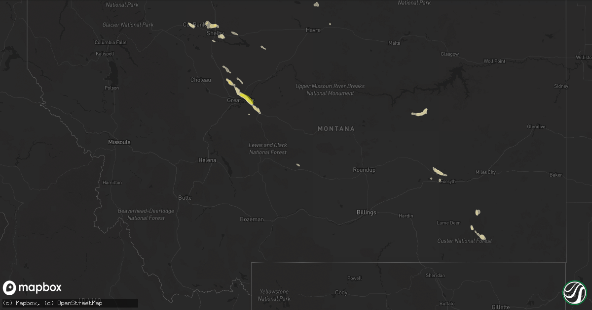
Hail Map in Montana on June 18, 2019
Get this storm
June 18 map
$229
one time, instant access
Download today. No call, no setup
Keep the $229
Bought the map and want the full workflow? Apply the entire $229 to a subscription within 7 days. None of it is wasted.
Every map, not just this one
This buys you this map. Subscription and you get every map we run, in the markets you choose from a few cities to whole states to nationwide. Plus real-time alerts the moment a storm fires.
Contact data
Name, contact info, occupancy, even credit band for addresses in the footprint. You go from where it hit to who to call.
Become the source they trust
Unlimited branding weather history reports on demand. You already have the documented answer ready for the property owner, and you are the one who showed up with it.
Property data and RoofTrace estimates
Pull up any address you have got, its value and the exact code rules for that jurisdiction, straight from One Click Code. Then RoofTrace estimates the squares, pitch, and roof value, priced the way you price.
Storm reports in Montana
Montana
| Date | Description |
|---|---|
| 06/18/20195:34 PM CDT | A local report indicates 65 MPH wind near 1 WNW INGOMAR |
| 06/18/20194:28 PM CDT | Quarter size or larger hail measured |
| 06/18/20197:49 AM CDT | At 1249 PM MDT, a severe thunderstorm was located 8 miles west of Kevin, or 10 miles northeast of Cut Bank, moving southeast at 25 mph. HAZARD...60 mph wind gusts and quarter size hail. SOURCE...Radar indicated. IMPACT...Hail damage to vehicles is expected. Expect wind damage to roofs, siding, and trees. Locations impacted include... Shelby, Kevin, Ferdig, Dunkirk and Oilmont. |
| 06/18/20194:01 AM CDT | At 901 PM MDT, a severe thunderstorm was located 16 miles southeast of Chester, moving east at 30 mph. HAZARD...60 mph wind gusts and quarter size hail. SOURCE...Radar indicated. IMPACT...Hail damage to vehicles is expected. Expect wind damage to roofs, siding, and trees. Locations impacted include... Kenilworth. |
| 06/18/20192:47 AM CDT | At 746 PM MDT, a severe thunderstorm was located near Lothair, or 18 miles west of Chester, moving east at 30 mph. HAZARD...60 mph wind gusts and quarter size hail. SOURCE...Radar indicated. IMPACT...Hail damage to vehicles is expected. Expect wind damage to roofs, siding, and trees. Locations impacted include... Chester, Lothair, Tiber Dam, Devon and Galata. |
| 06/18/20192:35 AM CDT | At 735 PM MDT, a severe thunderstorm was located 8 miles north of Shelby, moving east at 10 mph. HAZARD...60 mph wind gusts and quarter size hail. SOURCE...Radar indicated. IMPACT...Hail damage to vehicles is expected. Expect wind damage to roofs, siding, and trees. Locations impacted include... Oilmont and Ferdig. |
| 06/17/201911:44 PM CDT | At 443 PM MDT, a severe thunderstorm was located near Belt, or 16 miles southeast of Great Falls, moving southeast at 25 mph. HAZARD...60 mph wind gusts and quarter size hail. SOURCE...Hail up to one inch in diameter has been reported with this storm near Malmstrom Air Force Base. IMPACT...Hail damage to vehicles is expected. Expect wind damage to roofs, siding, and trees. This severe thunderstorm will remain over mainly rural areas of northwestern Judith Basin and northeastern Cascade Counties, including the following locations... Sluice Boxes State Park, Raynesford, Armington, Monarch and Centerville. |
| 06/17/201911:00 PM CDT | At 359 PM MDT, a severe thunderstorm was located just north of Black Eagle, or near Great Falls, moving southeast at 25 mph. HAZARD...60 mph wind gusts and half dollar size hail. SOURCE...Radar indicated. IMPACT...Hail damage to vehicles is expected. Expect wind damage to roofs, siding, and trees. This severe thunderstorm will be near... Malmstrom Air Force Base around 415 PM MDT and Belt around 440 PM MDT.Other locations impacted by this severe thunderstorm includeArmington, Portage, Malmstrom Afb, Sand Coulee, Stockett, Tracy andCenterville. |
| 06/17/201910:15 PM CDT | At 314 PM MDT, a severe thunderstorm was located 9 miles northeast of Power, or 20 miles northwest of Great Falls, moving southeast at 15 mph. HAZARD...60 mph wind gusts and quarter size hail. SOURCE...Radar indicated. IMPACT...Hail damage to vehicles is expected. Expect wind damage to roofs, siding, and trees. Locations impacted include... Floweree. |
| 06/17/20197:15 PM CDT | Report via twitter. Time is estimated. |
All States Impacted by Hail Map on June 18, 2019
Cities Impacted by Hail Map on June 18, 2019
- Joplin, MT
- Burden, KS
- Post, TX
- Eunice, NM
- Centerville, KS
- Garnett, KS
- Laverne, OK
- Woodward, OK
- Mooreland, OK
- Skellytown, TX
- Borger, TX
- Junction City, KS
- Felt, OK
- Telephone, TX
- Sharon, OK
- Chester, OK
- Wakita, OK
- Fairview, OK
- Erick, OK
- Tishomingo, OK
- Sanderson, TX
- Dryden, TX
- Richmond, KS
- Princeton, KS
- Elk City, KS
- Choctaw, OK
- Newalla, OK
- Mangum, OK
- Atlanta, KS
- Conway Springs, KS
- Courtland, VA
- Yale, VA
- Capron, VA
- Stony Creek, VA
- Gage, OK
- Shattuck, OK
- Okarche, OK
- Butler, OK
- Perryton, TX
- Longview, TX
- Manzanola, CO
- Rocky Ford, CO
- Manchester, OK
- Levelland, TX
- Littlefield, TX
- Anton, TX
- Pampa, TX
- Holly, CO
- Sublette, KS
- Ardmore, OK
- Ashton, ID
- Wellington, KS
- Turon, KS
- Chouteau, OK
- Locust Grove, OK
- Mclean, TX
- Wichita, KS
- Newcastle, TX
- Broken Arrow, OK
- Coweta, OK
- Texola, OK
- Willow, OK
- Sweetwater, OK
- Sayre, OK
- Udall, KS
- Winfield, KS
- Clarendon, TX
- Quail, TX
- Wellington, TX
- Shamrock, TX
- Deer Trail, CO
- Boise City, OK
- Grenville, NM
- Clayton, NM
- Abernathy, TX
- Pittsburg, TX
- Leesburg, TX
- Hamlin, TX
- McCaulley, TX
- Roby, TX
- Belt, MT
- Big Spring, TX
- Panhandle, TX
- Stinnett, TX
- Sunray, TX
- White Deer, TX
- Canon City, CO
- Lawton, OK
- Olney Springs, CO
- Boone, CO
- Fowler, CO
- Catoosa, OK
- Cordell, OK
- Corn, OK
- Colony, OK
- Stafford, KS
- Kingman, KS
- Arlington, KS
- Cunningham, KS
- Foss, OK
- Clinton, OK
- Latham, KS
- Cambridge, KS
- Gracemont, OK
- Havre, MT
- Balmorhea, TX
- Haven, KS
- Sulphur, OK
- Davis, OK
- Muleshoe, TX
- Aurora, CO
- Howard, KS
- Earth, TX
- Sudan, TX
- Medford, OK
- Canyon, TX
- Piedmont, OK
- Fargo, OK
- Fritch, TX
- Groom, TX
- Kevin, MT
- Shelby, MT
- Orange, VA
- Mineral, VA
- Dalhart, TX
- Holmdel, NJ
- Dayton, NJ
- Helmetta, NJ
- Spotswood, NJ
- Monroe Township, NJ
- East Brunswick, NJ
- Colts Neck, NJ
- Morganville, NJ
- Cranbury, NJ
- Monmouth Junction, NJ
- Marlboro, NJ
- Old Bridge, NJ
- Englishtown, NJ
- Bluff City, KS
- Calumet, OK
- Anson, TX
- Abilene, TX
- Saint Anthony, ID
- Rexburg, ID
- Snyder, TX
- Fluvanna, TX
- Crosbyton, TX
- Spur, TX
- Leon, KS
- Augusta, KS
- Hobbs, NM
- Lovington, NM
- Plains, KS
- Roaring Springs, TX
- Floydada, TX
- Hereford, TX
- Hallsville, TX
- Brusett, MT
- Jordan, MT
- Shidler, OK
- Kilgore, TX
- Argonia, KS
- Harper, KS
- Norwich, KS
- Konawa, OK
- Eureka, KS
- El Dorado, KS
- Lockney, TX
- Gretna, VA
- Nathalie, VA
- Java, VA
- Walsenburg, CO
- Elk City, OK
- Hammon, OK
- Canute, OK
- Collinsville, OK
- Skiatook, OK
- Sperry, OK
- Owasso, OK
- Lubbock, TX
- Shallowater, TX
- Wanette, OK
- Wapanucka, OK
- Coleman, OK
- Adrian, TX
- Cheney, KS
- Colorado Springs, CO
- Fountain, CO
- Detroit, TX
- Clarksville, TX
- Kim, CO
- Marathon, TX
- Coalgate, OK
- Clay Center, KS
- Cut Bank, MT
- Hennessey, OK
- Hulbert, OK
- Fort Gibson, OK
- Wagoner, OK
- Paris, TX
- Blossom, TX
- Coahoma, TX
- Bison, OK
- Hydro, OK
- Roswell, NM
- Tatum, TX
- Diana, TX
- Gilmer, TX
- Henderson, TX
- Harleton, TX
- Arapaho, OK
- Pueblo, CO
- Mount Pleasant, TX
- Talco, TX
- Petersburg, TX
- Ralls, TX
- Lorenzo, TX
- Two Dot, MT
- Miami, TX
- Idalou, TX
- Potwin, KS
- Slaton, TX
- Wilson, TX
- Hermleigh, TX
- Decatur, AR
- Woodford, VA
- Ruther Glen, VA
- Altamont, KS
- Carnegie, OK
- Fort Cobb, OK
- Branson, CO
- Picacho, NM
- Otter, MT
- Jetmore, KS
- Burrton, KS
- Halstead, KS
- Sedgwick, KS
- Stratford, TX
- Rose Hill, KS
- Douglass, KS
- Piedmont, KS
- Beulah, CO
- Rye, CO
- Holdenville, OK
- Hennepin, OK
- Tussy, OK
- Ratliff City, OK
- Duncan, OK
- Foster, OK
- Elmore City, OK
- Garden Plain, KS
- Seminole, TX
- Denver City, TX
- Wildorado, TX
- Marietta, OK
- Weatherford, OK
- Sedan, KS
- Cedar Vale, KS
- Mcconnell Afb, KS
- Trinchera, CO
- Trinidad, CO
- Barnsdall, OK
- Burbank, OK
- Pawhuska, OK
- Wynona, OK
- Model, CO
- Kingfisher, OK
- Watonga, OK
- Omega, OK
- Ira, TX
- Andover, KS
- Rock, KS
- Gate, OK
- Ada, OK
- Sasakwa, OK
- Valley Center, KS
- Rotan, TX
- Sweetwater, TX
- Westbrook, TX
- Colorado City, TX
- Sylvester, TX
- Loraine, TX
- Calhan, CO
- Cooper, TX
- Pecos, TX
- Pottsboro, TX
- Newton, KS
- Booker, TX
- Mount Hope, KS
- Alpine, TX
- Sanders, MT
- Clarksville, VA
- Cave Springs, AR
- Gentry, AR
- Springdale, AR
- Siloam Springs, AR
- Bentonville, AR
- Altus, OK
- Blair, OK
- Mountain View, OK
- Gotebo, OK
- Dumas, TX
- Deer Creek, OK
- Nardin, OK
- Blackwell, OK
- Inola, OK
- Hanston, KS
- Spearville, KS
- Vinson, OK
- Gould, OK
- Rush Springs, OK
- Nahunta, GA
- Belle Plaine, KS
- Partlow, VA
- Spotsylvania, VA
- Tahlequah, OK
- Tulsa, OK
- Kaw City, OK
- Claremore, OK
- Crescent, OK
- Wheeler, TX
- Aiken, SC
- Mount Vernon, TX
- Goddard, KS
- Hinton, OK
- Dimmitt, TX
- Nazareth, TX
- Walsh, CO
- Cashion, OK
- Edmond, OK
- Beaverdam, VA
- Louisa, VA
- Bumpass, VA
- Larned, KS
- Kinsley, KS
- Lanexa, VA
- Barhamsville, VA
- Mascot, VA
- West Point, VA
- Shacklefords, VA
- Mattaponi, VA
- Tonkawa, OK
- Billings, OK
- Parker, KS
- Havana, KS
- Paducah, TX
- Longton, KS
- Lexington, OK
- Brookneal, VA
- Randolph, VA
- Charlotte Court House, VA
- Lamesa, TX
- Ponca City, OK
- Red Rock, OK
- Sumner, TX
- Fort Davis, TX
- Tupelo, OK
- Union City, OK
- El Reno, OK
- Clearwater, KS
- Penhook, VA
- Rocky Mount, VA
- Norman, OK
- Maize, KS
- Chinook, MT
- Forsyth, MT
- Riverton, WY
- Espanola, NM
- Hernandez, NM
- Ohkay Owingeh, NM
- Kingston, OK
- Elgin, ND
- Avondale, CO
- Stratford, OK
- Burns, KS
- Minco, OK
- Shawnee, OK
- Byars, OK
- Wayne, OK
- Breckenridge, TX
- Colwich, KS
- Derby, KS
- Rosston, OK
- Great Falls, MT
- Dickens, TX
- Matador, TX
- Clover, VA
- Oklahoma City, OK
- Bethany, OK
- Sugar City, CO
- Cactus, TX
- Vici, OK
- Seiling, OK
- Roxton, TX
- Lake Creek, TX
- Andale, KS
- Ozona, TX
- Dacoma, OK
- Seminole, OK
- Geary, OK
- Brady, MT
- Buffalo, OK
- Meade, KS
- Cyril, OK
- Apache, OK
- New Leipzig, ND
- Plains, TX
- Mcadoo, TX
- Campbell, TX
- Danville, KS
- Dutton, MT
- Aline, OK
- Carmen, OK
- Crowell, TX
- Sherman, TX
- Fort Stockton, TX
- Tecumseh, OK
- Dover, OK
- Little Plymouth, VA
- Church View, VA
- Saluda, VA
- Thomas, OK
- Taloga, OK
- Grenola, KS
- Browns Summit, NC
- Reidsville, NC
- Beaumont, KS
- Murdock, KS
- Viola, KS
- Bentley, KS
- Moline, KS
- Oxford, KS
- Haysville, KS
- Mulvane, KS
- Peck, KS
- Milton, KS
- Big Sandy, TX
- Lookeba, OK
- Bennett, CO
- Oakwood, OK
- Fay, OK
- Okeene, OK
- Waukomis, OK
- Ames, OK
- Brookston, TX
- Arthur City, TX
- Albany, TX
- Las Animas, CO
- Kaufman, TX
- Wynnewood, OK
- Springer, OK
- Durant, OK
- Bokchito, OK
- Earlsboro, OK
- Claude, TX
- Freedom, OK
- Sulphur Bluff, TX
- Elgin, OK
- Fletcher, OK
- Fredonia, KS
- Black Eagle, MT
- Power, MT
- Sand Coulee, MT
- Saltillo, TX
- Cumby, TX
- Texline, TX
- Troy, NC
- New London, NC
- Denton, NC
- Asheboro, NC
- Scroggins, TX
- May, OK
- Pattonville, TX
- Deport, TX
- Neodesha, KS
- Marlow, OK
- Lindsay, OK
- Exmore, VA
- Dallas, TX
- Hutchins, TX
- Mannsville, OK
- Kenefic, OK
- Madill, OK
- Gladewater, TX
- Mountain Park, OK
- Tipton, OK
- Headrick, OK
- Indiahoma, OK
- Snyder, OK
- Chatham, VA
- Bennington, OK
- Lakin, KS
- Odonnell, TX
- Afton, TX
- Mutual, OK
- Anadarko, OK
- Galata, MT
- Fredericksburg, TX
- Binger, OK
- Granite, OK
- Lone Wolf, OK
- Calera, OK
- Mead, OK
- Millstone Township, NJ
- Caddo, OK
- Caney, OK
- Denison, TX
- Midlothian, TX
- Carthage, TX
- Long Branch, TX
- Dike, TX
- Honey Grove, TX
- Bogata, TX
- Fall River, KS
- Purcell, OK
- Cookville, TX
- Florissant, CO
- Independence, KS
- Hollis, OK
- Dewy Rose, GA
- Braman, OK
- Carter, OK
- Rocky, OK
- Hobart, OK
- Arnett, OK
- Pocasset, OK
- Atoka, OK
- Coldwater, KS
- Halifax, VA
- South Boston, VA
- Yukon, OK
- Grandview, TX
- Winona, TX
- Ulysses, KS
- Macomb, OK
- Sylvania, GA
- Conrad, MT
- Peru, KS
- Woodland, NC
- Ahoskie, NC
- Centerton, AR
- Gravette, AR
- Wyandotte, OK
- Windsor, SC
- Stockett, MT
- Follett, TX
- Ore City, TX
- Nassawadox, VA
- Okemah, OK
- Waynoka, OK
- Yoder, CO
- Seagraves, TX
- Ropesville, TX
- Lewis, KS
- Rich Square, NC
- Roxobel, NC
- Scotland Neck, NC
- Wakefield, KS
- Guthrie, OK
- Loving, TX
- Olney, TX
- Omaha, TX
- Freehold, NJ
- Sentinel, OK
- Lone Grove, OK
- Winfield, TX
- Meridian, OK
- Arcadia, OK
- Wolfforth, TX
- Brownfield, TX
- Luray, SC
- Terrell, TX
- Wills Point, TX
- Greenfield, OK
- Pritchett, CO
- Overbrook, OK
- Asher, OK
- Carter, MT
- Floweree, MT
- Newkirk, OK
- Cheyenne, OK
- Trappe, MD
- Hurlock, MD
- Federalsburg, MD
- Preston, MD
- Lincroft, NJ
- Colorado City, CO
- Ninnekah, OK
- Cement, OK
- Fort Sill, OK
- Medicine Park, OK
- Snow, OK
- Nashoba, OK
- Fittstown, OK
- Lamar, OK
- Stuart, OK
- Wardville, OK
- Stringtown, OK
- Clayton, OK
- Roff, OK
- Paoli, OK
- Allen, OK
- Wewoka, OK
- Pauls Valley, OK
- Maud, OK
- Pittsburg, OK
- Mcalester, OK
- Atwood, OK
- Fitzhugh, OK
- Calvin, OK
- Antlers, OK
- Daisy, OK
- Maysville, OK
- Kiowa, OK
- Centrahoma, OK
- Stonewall, OK
- Comanche, OK
- Noble, OK
- Elmer, OK
- Loveland, OK
- Roosevelt, OK
- Grandfield, OK
- Altus Afb, OK
- Duke, OK
- Devol, OK
- Davidson, OK
- Randlett, OK
- Burkburnett, TX
- Olustee, OK
- Wichita Falls, TX
- Temple, OK
- Frederick, OK
- Petrolia, TX
- Byers, TX
- Hollister, OK
- Alma, KS
- Paxico, KS
- Fieldton, TX
- Olton, TX
- Amherst, TX
- Hale Center, TX
- New Deal, TX
- Girard, TX
- Justiceburg, TX
- Seymour, TX
- Avinger, TX
- Lone Star, TX
- Elm Grove, LA
- Marshall, TX
- Haughton, LA
- Shreveport, LA
- Hughes Springs, TX
- Blanchard, LA
- Daingerfield, TX
- Mooringsport, LA
- Mansfield, LA
- Jefferson, TX
- Karnack, TX
- Barksdale Afb, LA
- Linden, TX
- Bossier City, LA
- Frierson, LA
- Vivian, LA
- Greenwood, LA
- White Oak, TX
- Hawkins, TX
- Waskom, TX
- Bridgeville, DE
- Seaford, DE
- Greenwood, DE
- Marfa, TX


