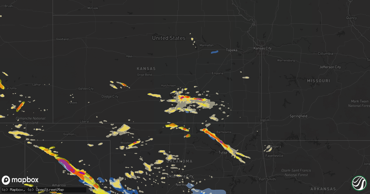
Hail Map on June 18, 2019
Get this storm
June 18 map
$229
one time, instant access
Download today. No call, no setup
Keep the $229
Bought the map and want the full workflow? Apply the entire $229 to a subscription within 7 days. None of it is wasted.
Every map, not just this one
This buys you this map. Subscription and you get every map we run, in the markets you choose from a few cities to whole states to nationwide. Plus real-time alerts the moment a storm fires.
Contact data
Name, contact info, occupancy, even credit band for addresses in the footprint. You go from where it hit to who to call.
Become the source they trust
Unlimited branding weather history reports on demand. You already have the documented answer ready for the property owner, and you are the one who showed up with it.
Property data and RoofTrace estimates
Pull up any address you have got, its value and the exact code rules for that jurisdiction, straight from One Click Code. Then RoofTrace estimates the squares, pitch, and roof value, priced the way you price.
States Impacted by Hail Map on June 18, 2019
Storm reports
Montana
| Date | Description |
|---|---|
| 06/18/20195:34 PM CDT | A local report indicates 65 MPH wind near 1 WNW INGOMAR |
| 06/18/20194:28 PM CDT | Quarter size or larger hail measured |
| 06/18/20197:49 AM CDT | At 1249 PM MDT, a severe thunderstorm was located 8 miles west of Kevin, or 10 miles northeast of Cut Bank, moving southeast at 25 mph. HAZARD...60 mph wind gusts and quarter size hail. SOURCE...Radar indicated. IMPACT...Hail damage to vehicles is expected. Expect wind damage to roofs, siding, and trees. Locations impacted include... Shelby, Kevin, Ferdig, Dunkirk and Oilmont. |
| 06/18/20194:01 AM CDT | At 901 PM MDT, a severe thunderstorm was located 16 miles southeast of Chester, moving east at 30 mph. HAZARD...60 mph wind gusts and quarter size hail. SOURCE...Radar indicated. IMPACT...Hail damage to vehicles is expected. Expect wind damage to roofs, siding, and trees. Locations impacted include... Kenilworth. |
| 06/18/20192:47 AM CDT | At 746 PM MDT, a severe thunderstorm was located near Lothair, or 18 miles west of Chester, moving east at 30 mph. HAZARD...60 mph wind gusts and quarter size hail. SOURCE...Radar indicated. IMPACT...Hail damage to vehicles is expected. Expect wind damage to roofs, siding, and trees. Locations impacted include... Chester, Lothair, Tiber Dam, Devon and Galata. |
| 06/18/20192:35 AM CDT | At 735 PM MDT, a severe thunderstorm was located 8 miles north of Shelby, moving east at 10 mph. HAZARD...60 mph wind gusts and quarter size hail. SOURCE...Radar indicated. IMPACT...Hail damage to vehicles is expected. Expect wind damage to roofs, siding, and trees. Locations impacted include... Oilmont and Ferdig. |
| 06/17/201911:44 PM CDT | At 443 PM MDT, a severe thunderstorm was located near Belt, or 16 miles southeast of Great Falls, moving southeast at 25 mph. HAZARD...60 mph wind gusts and quarter size hail. SOURCE...Hail up to one inch in diameter has been reported with this storm near Malmstrom Air Force Base. IMPACT...Hail damage to vehicles is expected. Expect wind damage to roofs, siding, and trees. This severe thunderstorm will remain over mainly rural areas of northwestern Judith Basin and northeastern Cascade Counties, including the following locations... Sluice Boxes State Park, Raynesford, Armington, Monarch and Centerville. |
| 06/17/201911:00 PM CDT | At 359 PM MDT, a severe thunderstorm was located just north of Black Eagle, or near Great Falls, moving southeast at 25 mph. HAZARD...60 mph wind gusts and half dollar size hail. SOURCE...Radar indicated. IMPACT...Hail damage to vehicles is expected. Expect wind damage to roofs, siding, and trees. This severe thunderstorm will be near... Malmstrom Air Force Base around 415 PM MDT and Belt around 440 PM MDT.Other locations impacted by this severe thunderstorm includeArmington, Portage, Malmstrom Afb, Sand Coulee, Stockett, Tracy andCenterville. |
| 06/17/201910:15 PM CDT | At 314 PM MDT, a severe thunderstorm was located 9 miles northeast of Power, or 20 miles northwest of Great Falls, moving southeast at 15 mph. HAZARD...60 mph wind gusts and quarter size hail. SOURCE...Radar indicated. IMPACT...Hail damage to vehicles is expected. Expect wind damage to roofs, siding, and trees. Locations impacted include... Floweree. |
| 06/17/20197:15 PM CDT | Report via twitter. Time is estimated. |
Georgia
| Date | Description |
|---|---|
| 06/18/20194:25 PM CDT | 1 tree down across a lane of hwy 42 near bryant rd. |
| 06/18/20194:20 PM CDT | Tree down at forsyth st. |
| 06/18/20194:06 PM CDT | A tree was reported down on trice cemetary road just north of smith road. |
| 06/18/20194:06 PM CDT | A tree was reported down on worthy road. Reports of power outages in the area. |
| 06/18/20193:40 PM CDT | Tree limb down on powerline along hwy 142 near newton ridge. |
| 06/18/201912:10 AM CDT | At 509 PM EDT, a severe thunderstorm was located over Redbone Crossroads, or near Thomaston, moving east at 20 mph. HAZARD...60 mph wind gusts. SOURCE...Radar indicated. IMPACT...Expect damage to roofs, siding, and trees. Locations impacted include... Thomaston, Forsyth, Roberta, Yatesville, Culloden, Sunset Village, Lincoln Park, The Rock, Lake Tobesofkee, Russellville, Logtown, Sunnyside, Salem, Horns, Collier, Fickling Mill, Jack Brown Estates, Redbone Crossroads, Brent and Musella. |
| 06/17/201911:36 PM CDT | At 436 PM EDT, a severe thunderstorm was located over Hilltop, or near Zebulon, moving northeast at 20 mph. HAZARD...60 mph wind gusts and penny size hail. SOURCE...Radar indicated. IMPACT...Expect damage to roofs, siding, and trees. Locations impacted include... Zebulon, Williamson, Rover and Hilltop. |
| 06/17/201910:28 PM CDT | At 327 PM EDT, a severe thunderstorm was located over Conyers, moving northeast at 15 mph. HAZARD...60 mph wind gusts. SOURCE...Radar indicated. IMPACT...Expect damage to roofs, siding, and trees. Locations impacted include... Conyers, Covington, Snellville, Loganville, Social Circle, Oxford, Lithonia, Walnut Grove, Between, Jersey, Lakeview Estates, Georgia International Horse Park, Magnet, Almon, Milstead, Youth, Arabia Mountain, Big Haynes Creek Park, Rosebud and Gum Creek. |
Louisiana
| Date | Description |
|---|---|
| 06/18/20196:58 AM CDT | Large tree limbs were downed on dixie-shreveport road between whitfield circle and sentell road. |
| 06/18/20196:50 AM CDT | Trees and power lines down on riviera street between crawford road and tacoma blvd. |
Arkansas
| Date | Description |
|---|---|
| 06/18/20195:18 AM CDT | A few large trees down including one blocking the road just s of the intersection of highway 59 and 45. Report received via social media. |
Mississippi
| Date | Description |
|---|---|
| 06/18/20194:42 AM CDT | At 941 AM CDT, a severe thunderstorm was located 16 miles east of Perkinston, or 16 miles east of Wiggins, moving northeast at 40 mph. HAZARD...60 mph wind gusts. SOURCE...Radar indicated. IMPACT...Expect damage to roofs, siding, and trees. Locations impacted include... Lucedale. |
| 06/18/20194:24 AM CDT | At 923 AM CDT, severe thunderstorms were located along a line extending from 7 miles east of Perkinston to Gulfport, moving northeast at 30 mph. HAZARD...60 mph wind gusts. SOURCE...Radar indicated. IMPACT...Expect damage to roofs, siding, and trees. Locations impacted include... Gulfport, Biloxi, Ocean Springs, Long Beach, St. Martin, D'iberville, Saucier, Latimer, Gulf Hills, Lyman and Gulfport Airport. |
| 06/18/20194:20 AM CDT | At 920 AM CDT, severe thunderstorms were located along a line extending from 6 miles southwest of Maxie to near Perkinston to 4 miles east of Saucier, moving northeast at 40 mph. HAZARD...60 mph wind gusts. SOURCE...Radar indicated. IMPACT...Expect damage to roofs, siding, and trees. Locations impacted include... Wiggins and Perkinston. |
| 06/18/20193:39 AM CDT | At 839 AM CDT, a severe thunderstorm was located 7 miles east of Maxie, or 8 miles northeast of Wiggins, moving northeast at 15 mph. HAZARD...60 mph wind gusts. SOURCE...Radar indicated. IMPACT...Expect damage to roofs, siding, and trees. This severe thunderstorm will remain over mainly rural areas of southwestern Perry County. |
North Carolina
| Date | Description |
|---|---|
| 06/18/20191:07 AM CDT | At 607 PM EDT, a severe thunderstorm was located over Monroeton, moving northeast at 20 mph. HAZARD...60 mph wind gusts and quarter size hail. SOURCE...Radar indicated. IMPACT...Hail damage to vehicles is expected. Expect wind damage to roofs, siding, and trees. Locations impacted include... Danville... Reidsville... Wentworth... Yanceyville... and Bethel. |
Texas
| Date | Description |
|---|---|
| 06/18/20196:55 PM CDT | A local report indicates 1.25 inch wind near 4 WNW CANYON |
| 06/18/20196:54 PM CDT | Quarter sized hail as well as 60 mph winds reported. |
| 06/18/20196:27 PM CDT | Hail less golfball size in the sand springs area along with 60 mph winds. |
| 06/18/20196:25 PM CDT | Hail falling at time of call. |
| 06/18/20196:20 PM CDT | A local report indicates 1.00 inch wind near COAHOMA |
| 06/18/20196:19 PM CDT | A local report indicates 1.75 inch wind near 6 S CONLEN |
| 06/18/20196:08 PM CDT | Late report from area ranchers of dime to a few quarter size hail stones. Time estimated from radar. |
| 06/18/20196:08 PM CDT | A local report indicates 1.75 inch wind near MARATHON |
| 06/18/20196:05 PM CDT | Mix of dime to half dollar sized stones near the post office in marathon. |
| 06/18/20196:04 PM CDT | A local report indicates 1.00 inch wind near 5 S MARATHON |
| 06/18/20196:04 PM CDT | A local report indicates 60 MPH wind near 5 S MARATHON |
| 06/18/20195:53 PM CDT | Late report of half dollar size hail along u.s. Highway 54 near conlen. Time estimated from radar. |
| 06/18/20194:34 PM CDT | Nickel and quarter size hail. |
| 06/18/20194:28 PM CDT | A local report indicates 61 MPH wind near 1 NW FORT STOCKTON |
| 06/18/20194:12 PM CDT | A local report indicates 1.00 inch wind near 5 SW STRATFORD |
| 06/18/20193:35 PM CDT | Lots of quarter and golf ball sized hail mixed. |
| 06/18/20193:07 PM CDT | A local report indicates 1.00 inch wind near 7 S MARFA |
| 06/18/20197:58 AM CDT | At 1258 AM MDT, a severe thunderstorm was located over McDonald, or near Tatum, moving east at 20 mph. HAZARD...Golf ball size hail and 70 mph wind gusts. SOURCE...Radar indicated. IMPACT...People and animals outdoors will be injured. Expect hail damage to roofs, siding, windows, and vehicles. Expect considerable tree damage. Wind damage is also likely to mobile homes, roofs, and outbuildings. Locations impacted include... Tatum, McDonald, Gladiola and Tatum Airport. |
| 06/18/20196:54 AM CDT | At 1153 PM CDT, severe thunderstorms were located along a line extending from near Sentinel to 7 miles northwest of Roosevelt to 5 miles northeast of Gould, moving southeast at 35 mph. HAZARD...60 mph wind gusts and nickel size hail. SOURCE...Radar indicated. IMPACT...Expect damage to roofs, siding, and trees. Locations impacted include... Altus, Frederick, Hobart, Mangum, Cache, Granite, Snyder, Tipton, Blair, Olustee, Lone Wolf, Mountain Park, Medicine Park, Indiahoma, Roosevelt, Gotebo, Manitou, Martha, Elmer and Headrick. |
| 06/18/20196:47 AM CDT | Two transformers damaged... One on fire and one smoking... One 79n just past city limit of carthage... And one cr 30 across from the dcp plant. |
| 06/18/20196:34 AM CDT | Tree down on cr 241 off of fm 124 near beckville. |
| 06/18/20196:30 AM CDT | Tree down hwy 43 toward marshall... 1.5 miles north of tatum city limits. |
| 06/18/20196:15 AM CDT | Damage to several signs and billboard hwy 59 and hwy 80 intersection. |
| 06/18/20196:15 AM CDT | Tree down causing damage to home on rusk street. |
| 06/18/20196:08 AM CDT | Firefighter reports damage to home... Porch ripped off haynes road off hwy 154 nesbitt... Tx just west of marshall. |
| 06/18/20196:07 AM CDT | At 1107 PM CDT, severe thunderstorms were located along a line extending from near Sayre to near Erick to near Wellington, moving east at 35 mph. HAZARD...70 mph wind gusts and quarter size hail. SOURCE...Radar indicated. IMPACT...Expect considerable tree damage. Wind damage is also likely to mobile homes, roofs, and outbuildings. Locations impacted include... Mangum, Hollis, Granite, Erick, Blair, Lone Wolf, Martha, Willow, Gould, Delhi, Vinson, Duke, Warren, Madge, Brinkman, Hester, McQueen, McKnight and Altus-Lugert Lake. |
| 06/18/20196:03 AM CDT | Nws storm survey confirmed and ef-0 tornado. Tornado touched down briefly along highway 450 where it uprooted trees and snapped branches. |
| 06/18/20196:00 AM CDT | Nws storm survery confrimed straight line wind damage. Wind damage included trees uprooted and snapped... As well as roof damage to a barn and carport on a house. Major |
| 06/18/20195:57 AM CDT | At 1056 PM CDT, severe thunderstorms were located along a line extending from 10 miles southeast of Acres to near Buffalo to 10 miles northeast of Follett, moving east at 40 mph. HAZARD...70 mph wind gusts and nickel size hail. SOURCE...Radar indicated. IMPACT...Expect considerable tree damage. Damage is likely to mobile homes, roofs, and outbuildings. Locations impacted include... Woodward, Laverne, Buffalo, Mooreland, Fargo, Fort Supply, Freedom, May, Alabaster Caverns State Park, Selman, Tangier, Catesby and Camp Houston. |
| 06/18/20195:52 AM CDT | Sheriffs office reports trees down county wide. |
| 06/18/20195:45 AM CDT | Large tree down off 729 and 155 south of lone star... Power out in several areas county wide. |
| 06/18/20195:34 AM CDT | Numerous trees were downed across upshur county. |
| 06/18/20195:26 AM CDT | At 1026 PM CDT, severe thunderstorms were located along a line extending from 3 miles south of Swearingen to 7 miles southeast of Chalk to 4 miles north of Guthrie, moving east at 45 mph. HAZARD...70 mph wind gusts and quarter size hail. SOURCE...Radar indicated. IMPACT...Hail damage to vehicles is expected. Expect considerable tree damage. Wind damage is also likely to mobile homes, roofs, and outbuildings. Locations impacted include... Crowell, Benjamin, Margaret, Vera, Thalia, Truscott, Gilliland, Rhineland, Rayland and Copper Breaks State Park. |
| 06/18/20195:13 AM CDT | At 1013 PM CDT, a severe thunderstorm was located near Knowles, or 14 miles east of Beaver, moving east at 55 mph. HAZARD...60 mph wind gusts. SOURCE...Radar indicated. IMPACT...Minor damage to roofs, siding, and trees is possible. Locations impacted include... Gate, Knowles, Elmwood and Slapout. |
| 06/18/20195:05 AM CDT | At 1005 PM CDT, a severe thunderstorm was located 4 miles west of Chalk, or 9 miles south of Paducah, moving east at 40 mph. HAZARD...60 mph wind gusts and quarter size hail. SOURCE...Radar indicated. IMPACT...Hail damage to vehicles is expected. Expect wind damage to roofs, siding, and trees. Locations impacted include... Paducah, Finney, Grow, Chalk and Swearingen. |
| 06/18/20195:02 AM CDT | Trees down and power outages in city of pittsburg and around the county. |
| 06/18/20195:01 AM CDT | At 1001 PM CDT, a severe thunderstorm was located 6 miles north of Clairemont, or 11 miles west of Jayton, moving southeast at 25 mph. HAZARD...60 mph wind gusts and quarter size hail. SOURCE...Radar indicated. IMPACT...Hail damage to vehicles is expected. Expect wind damage to roofs, siding, and trees. Locations impacted include... Jayton, Lake Alan Henry, Girard, Peacock, Justiceburg, Swenson and Clairemont. |
| 06/18/20194:40 AM CDT | At 939 PM CDT, a severe thunderstorm was located 6 miles southwest of Lefors, or 14 miles southeast of Pampa, moving southeast at 30 mph. HAZARD...Two inch hail and 70 mph wind gusts. SOURCE...Radar indicated. IMPACT...Expect some tree damage. Damage is likely to mobile homes, roofs, and outbuildings. People and animals outdoors will be injured. Expect hail damage to roofs, siding, windows, and vehicles. Locations impacted include... Mclean, Lefors, Lela, Alanreed, Lake Mcclellan and Kellerville. |
| 06/18/20194:30 AM CDT | At 930 PM CDT, a severe thunderstorm was located 6 miles east of Matador, moving east at 40 mph. HAZARD...60 mph wind gusts and quarter size hail. SOURCE...Radar indicated. IMPACT...Hail damage to vehicles is expected. Expect wind damage to roofs, siding, and trees. Locations impacted include... Paducah, Matador, Cee Vee, Dumont, Northfield, Delwin, Afton and Roaring Springs. |
| 06/18/20194:12 AM CDT | At 912 PM CDT, a severe thunderstorm was located 4 miles northwest of White River Lake, moving southeast at 25 mph. HAZARD...Ping pong ball size hail and 60 mph wind gusts. SOURCE...Radar indicated. IMPACT...People and animals outdoors will be injured. Expect hail damage to roofs, siding, windows, and vehicles. Expect wind damage to roofs, siding, and trees. Locations impacted include... Crosbyton, Spur, Dickens, White River Lake, Ralls, Kalgary, Caprock and Mcadoo. |
| 06/18/20193:48 AM CDT | At 847 PM CDT, a severe thunderstorm was located 7 miles southwest of Stamford, moving east at 30 mph. HAZARD...60 mph wind gusts and nickel size hail. SOURCE...Radar indicated. IMPACT...Expect damage to roofs, siding, and trees. This severe thunderstorm will be near... Avoca around 910 PM CDT. Lake Stamford Marina around 925 PM CDT. Stamford around 930 PM CDT.Other locations impacted by this severe thunderstorm include Funston,Big Country Baptist Assembly, The Intersection Of Us-180 And Farm Road 600 and Tuxedo. |
| 06/18/20193:44 AM CDT | At 843 PM CDT, a severe thunderstorm was located near Pampa, moving southeast at 20 mph. HAZARD...Ping pong ball size hail and 60 mph wind gusts. SOURCE...Radar indicated. IMPACT...Minor damage to roofs, siding, and trees is possible. People and animals outdoors will be injured. Expect hail damage to roofs, siding, windows, and vehicles. Locations impacted include... Pampa, Mclean, Lefors, New Mobeetie, Lake Mcclellan, Alanreed, Kellerville and Mobeetie. |
| 06/18/20193:42 AM CDT | At 842 PM CDT, a severe thunderstorm was located 4 miles southeast of Borger, moving southeast at 30 mph. This is a very dangerous storm. HAZARD...80 mph wind gusts and baseball size hail. SOURCE...Emergency management. At 837 PM CDT, emergency management reported an 86 mph gust on the southeast side of Borger. IMPACT...People and animals outdoors will be severely injured. Expect shattered windows, extensive damage to roofs, siding, and vehicles. Locations impacted include... Pampa, Borger, Panhandle, White Deer, Skellytown, Kingsmill and Codman. |
| 06/18/20193:29 AM CDT | At 828 PM CDT, a severe thunderstorm was located 4 miles east of Shallowater, or 6 miles north of Lubbock, moving east at 25 mph. HAZARD...Ping pong ball size hail and 60 mph wind gusts. SOURCE...Radar indicated. IMPACT...People and animals outdoors will be injured. Expect hail damage to roofs, siding, windows, and vehicles. Expect wind damage to roofs, siding, and trees. Locations impacted include... Lubbock, Slaton, Wolfforth, Shallowater, Idalou, Ransom Canyon, Lubbock South Plains Mall, Texas Tech University, Lubbock International Airport, Slide, Downtown Lubbock, Woodrow, Reese Center, New Deal, Smyer, Ropesville and Lubbock Science Spectrum. |
| 06/18/20193:19 AM CDT | At 818 PM CDT, a severe thunderstorm was located near Mccaulley, or near Hamlin, moving east at 30 mph. HAZARD...60 mph wind gusts and quarter size hail. SOURCE...Radar indicated. IMPACT...Hail damage to vehicles is expected. Expect wind damage to roofs, siding, and trees. This severe thunderstorm will be near... Neinda around 825 PM CDT. Hamlin around 830 PM CDT.Other locations impacted by this severe thunderstorm include TheIntersection Of Us-180 And Ranch Road 126, Hitson and Tuxedo. |
| 06/18/20193:15 AM CDT | At 814 PM CDT, a severe thunderstorm was located 9 miles southeast of Fluvanna, or 9 miles northwest of Snyder, moving northeast at 25 mph. HAZARD...Ping pong ball size hail and 60 mph wind gusts. SOURCE...Radar indicated. IMPACT...People and animals outdoors will be injured. Expect hail damage to roofs, siding, windows, and vehicles. Expect wind damage to roofs, siding, and trees. Locations impacted include... Snyder, Randalls Corner and Winston Field. |
| 06/18/20193:12 AM CDT | At 812 PM CDT, a severe thunderstorm was located 4 miles southeast of Abernathy, moving east at 35 mph. HAZARD...60 mph wind gusts and quarter size hail. SOURCE...Radar indicated. IMPACT...Hail damage to vehicles is expected. Expect wind damage to roofs, siding, and trees. Locations impacted include... Floydada, Crosbyton, Ralls, Petersburg, Lorenzo and Cone. |
| 06/18/20192:59 AM CDT | At 759 PM CDT, a severe thunderstorm was located 6 miles northwest of Pampa, moving east at 20 mph. HAZARD...60 mph wind gusts and quarter size hail. SOURCE...Radar indicated. IMPACT...Minor damage to roofs, siding, and trees is possible. Hail damage to vehicles is expected. Locations impacted include... Pampa, Skellytown and Codman. |
| 06/18/20192:52 AM CDT | At 751 PM CDT, a severe thunderstorm was located near Roby, or 18 miles north of Sweetwater, moving northeast at 35 mph. HAZARD...60 mph wind gusts and quarter size hail. SOURCE...Radar indicated. IMPACT...Hail damage to vehicles is expected. Expect wind damage to roofs, siding, and trees. This severe thunderstorm will be near... Roby around 800 PM CDT. Sylvester around 815 PM CDT. Mccaulley around 830 PM CDT.Other locations impacted by this severe thunderstorm include Busbyand Capitola. |
| 06/18/20192:46 AM CDT | At 746 PM CDT, severe thunderstorms were located along a line extending from 22 miles southeast of Spearman to 8 miles northwest of Pampa, moving east at 25 mph. HAZARD...Ping pong ball size hail and 60 mph wind gusts. SOURCE...Radar indicated. IMPACT...Minor damage to roofs, siding, and trees is possible. People and animals outdoors will be injured. Expect hail damage to roofs, siding, windows, and vehicles. Locations impacted include... Miami, Codman and Lora. |
| 06/18/20192:41 AM CDT | At 740 PM CDT, a severe thunderstorm was located 5 miles southwest of Palo Duro Canyon, or 10 miles southeast of Canyon, moving east at 20 mph. HAZARD...Ping pong ball size hail and 60 mph wind gusts. SOURCE...Radar indicated. IMPACT...Minor damage to roofs, siding, and trees is possible. People and animals outdoors will be injured. Expect hail damage to roofs, siding, windows, and vehicles. Hail may accumulate on roadways causing hazardous travel. Locations impacted include... Wayside and Palo Duro Canyon. |
| 06/18/20192:36 AM CDT | At 735 PM CDT, a severe thunderstorm was located near Whitharral, or 9 miles south of Littlefield, moving east at 30 mph. HAZARD...Ping pong ball size hail and 60 mph wind gusts. SOURCE...Radar indicated. IMPACT...People and animals outdoors will be injured. Expect hail damage to roofs, siding, windows, and vehicles. Expect wind damage to roofs, siding, and trees. Locations impacted include... Lubbock, Abernathy, Shallowater, Anton, Texas Tech University, Whitharral, Reese Center and New Deal. |
| 06/18/20192:24 AM CDT | At 724 PM CDT, a severe thunderstorm was located near Sunray, or 9 miles northeast of Dumas, moving southeast at 25 mph. HAZARD...Two inch hail and 60 mph wind gusts. SOURCE...Radar indicated. IMPACT...Minor damage to roofs, siding, and trees is possible. People and animals outdoors will be injured. Expect hail damage to roofs, siding, windows, and vehicles. Locations impacted include... Cactus, Sunray, Stinnett, Sanford and Pringle. |
| 06/18/20192:21 AM CDT | At 721 PM CDT, a severe thunderstorm was located near Inadale, or 14 miles northwest of Roscoe, moving northeast at 40 mph. This is a very dangerous storm. HAZARD...80 mph wind gusts and quarter size hail. SOURCE...Radar indicated. IMPACT...Flying debris will be dangerous to those caught without shelter. Mobile homes will be heavily damaged. Expect considerable damage to roofs, windows, and vehicles. Extensive tree damage and power outages are likely. This severe thunderstorm will be near... Hobbs around 740 PM CDT.Other locations impacted by this severe thunderstorm include Gannon,Busby, Capitola, Us-180 Near The Fisher-Scurry County Line and Us-84 Near The Nolan-Fisher County Line. |
| 06/18/20192:20 AM CDT | At 720 PM CDT, a severe thunderstorm was located 10 miles southwest of Lamesa, moving northeast at 40 mph. HAZARD...60 mph wind gusts and quarter size hail. SOURCE...Radar indicated. IMPACT...Hail damage to vehicles is expected. Expect wind damage to roofs, siding, and trees. Locations impacted include... Lamesa, Lamesa Municipal Airport, Los Ybanez, Sparenberg, Tenmile, Patricia, Punkin Center, Arvana, Hancock, Key and Klondike. |
| 06/18/20192:20 AM CDT | At 720 PM MDT, a severe thunderstorm was located near Clayton Lake State Park, or 9 miles north of Clayton, moving east at 20 mph. HAZARD...60 mph wind gusts and half dollar size hail. SOURCE...Radar indicated. IMPACT...Hail damage to vehicles is expected. Expect wind damage to roofs, siding, and trees. Locations impacted include... Clayton, Clayton Lake State Park, Seneca and Moses. |
| 06/18/20192:11 AM CDT | At 711 PM CDT, a severe thunderstorm was located 20 miles northeast of Pandale, or 21 miles southwest of Ozona, moving east at 20 mph. HAZARD...60 mph wind gusts and quarter size hail. SOURCE...Radar indicated. IMPACT...Hail damage to vehicles is expected. Expect wind damage to roofs, siding, and trees. This severe thunderstorm will remain over mainly rural areas of southeastern Crockett County, including the following locations... The Intersection Of Ranch Road 2083 And Highway 405, The Intersection Of Highway 163 And Ranch Road 1973 and I-10 Near The Crockett-Sutton County Line.This includes Interstate 10 near Mile Marker 379. |
| 06/18/20191:54 AM CDT | At 653 PM CDT, a severe thunderstorm was located 12 miles northeast of Coahoma, or 16 miles west of Colorado City, moving northeast at 40 mph. This storm has had a history of producing ping pong ball sized hail. HAZARD...Ping pong ball size hail and 60 mph wind gusts. SOURCE...Radar indicated. IMPACT...People and animals outdoors will be injured. Expect hail damage to roofs, siding, windows, and vehicles. Expect wind damage to roofs, siding, and trees. Locations impacted include... Snyder, Colorado City, Loraine, Colorado City Airport, Lake Colorado City, Lake Colorado City State Park, Inadale, Champion Creek Reservoir, J B Thomas Reservoir, Westbrook, Hermleigh, Randalls Corner, Winston Field, Cuthbert, Knapp, Buford, Dunn and Ira.This includes Interstate 20 between mile markers 203 and 228. |
| 06/18/20191:50 AM CDT | At 650 PM CDT, a severe thunderstorm was located 4 miles north of Umbarger, or 9 miles west of Canyon, moving east at 30 mph. HAZARD...60 mph wind gusts and half dollar size hail. SOURCE...Radar indicated. IMPACT...Minor damage to roofs, siding, and trees is possible. Hail damage to vehicles is expected. Locations impacted include... Amarillo, Canyon, Lake Tanglewood, Mescalero Park, Palo Duro Canyon and Timbercreek Canyon. |
| 06/18/20191:39 AM CDT | At 639 PM CDT, a severe thunderstorm was located 7 miles northwest of Cactus, or 14 miles south of Stratford, moving east at 25 mph. HAZARD...60 mph wind gusts and quarter size hail. SOURCE...Radar indicated. IMPACT...Minor damage to roofs, siding, and trees is possible. Hail damage to vehicles is expected. Locations impacted include... Cactus and Sunray. |
| 06/18/20191:29 AM CDT | At 628 PM CDT, a severe thunderstorm was located 11 miles east of Arch, or 16 miles southwest of Muleshoe, moving east at 30 mph. HAZARD...70 mph wind gusts and ping pong ball size hail. SOURCE...Radar indicated. IMPACT...People and animals outdoors will be injured. Expect hail damage to roofs, siding, windows, and vehicles. Expect considerable tree damage. Wind damage is also likely to mobile homes, roofs, and outbuildings. Locations impacted include... Muleshoe, Olton, Earth, Sudan, Needmore and Springlake. |
| 06/18/20191:07 AM CDT | At 607 AM CDT, a severe thunderstorm was located near De Leon, or 15 miles northwest of Dublin, moving southeast at 50 mph. HAZARD...65 mph wind gusts and quarter size hail. SOURCE...Radar indicated. IMPACT...Hail damage to vehicles is expected. Expect wind damage to roofs, siding, and trees. Locations impacted include... Stephenville, Comanche, Dublin, De Leon, Gorman and Gustine. |
| 06/18/20191:00 AM CDT | At 559 PM CDT, a severe thunderstorm was located near Sand Springs, or near Big Spring, moving northeast at 30 mph. Storm has intensified quickly. HAZARD...60 mph wind gusts and quarter size hail. SOURCE...Radar indicated. IMPACT...Hail damage to vehicles is expected. Expect wind damage to roofs, siding, and trees. Locations impacted include... Big Spring, Coahoma, Forsan, Sand Springs, Colorado City Airport, Luther, Westbrook, Vincent, Cuthbert, Buford, Big Spring Country Club, Big Spring McMahon-Wrinkle Airpark and Elbow.This includes Interstate 20 between mile markers 172 and 210. |
| 06/18/201912:55 AM CDT | At 555 PM CDT, a severe thunderstorm was located over Conlen, or 14 miles southwest of Stratford, moving east at 20 mph. HAZARD...60 mph wind gusts and half dollar size hail. SOURCE...Radar indicated. IMPACT...Minor damage to roofs, siding, and trees is possible. Hail damage to vehicles is expected. Locations impacted include... Cactus and Conlen. |
| 06/18/201912:50 AM CDT | At 550 PM CDT, a severe thunderstorm was located 9 miles east of Simms, or 14 miles northwest of Hereford, moving northeast at 25 mph. HAZARD...Golf ball size hail and 60 mph wind gusts. SOURCE...Radar indicated. IMPACT...Minor damage to roofs, siding, and trees is possible. People and animals outdoors will be injured. Expect hail damage to roofs, siding, windows, and vehicles. Locations impacted include... Wildorado. |
| 06/18/201912:47 AM CDT | At 547 PM CDT, a severe thunderstorm was located 7 miles east of Texhoma, or 17 miles southwest of Guymon, moving northeast at 35 mph. HAZARD...60 mph wind gusts and quarter size hail. SOURCE...Radar indicated. IMPACT...Minor damage to roofs, siding, and trees is possible. Hail damage to vehicles is expected. Locations impacted include... Hardesty. |
| 06/18/201912:35 AM CDT | At 534 PM CDT, a severe thunderstorm was located 18 miles southwest of Marathon, or 32 miles southeast of Alpine, moving north at 35 mph. HAZARD...Ping pong ball size hail and 60 mph wind gusts. SOURCE...Radar indicated. IMPACT...People and animals outdoors will be injured. Expect hail damage to roofs, siding, windows, and vehicles. Expect wind damage to roofs, siding, and trees. Locations impacted include... Marathon and Elephant Mountain Wildlife Management Area. |
| 06/18/201912:13 AM CDT | At 513 PM CDT, a severe thunderstorm was located 12 miles northeast of Ware, or 19 miles north of Dalhart, moving east at 25 mph. HAZARD...60 mph wind gusts and quarter size hail. SOURCE...Radar indicated. IMPACT...Minor damage to roofs, siding, and trees is possible. Hail damage to vehicles is expected. Locations impacted include... Conlen. |
| 06/18/201912:12 AM CDT | At 511 AM CDT, a severe thunderstorm was located near Moran, or 12 miles northwest of Cisco, moving southeast at 30 mph. HAZARD...60 mph wind gusts and penny size hail. SOURCE...Radar indicated. Just before 5 AM...a wind gust to 57 MPH was observed near Clyde. IMPACT...Expect damage to roofs, siding, and trees. Locations impacted include... Eastland, Cisco, Ranger, Gorman, Rising Star, Gunsight and Carbon. This includes Interstate 20 between mile markers 324 and 358. |
| 06/18/201912:05 AM CDT | At 504 AM CDT, a severe thunderstorm was located over Moran, or 14 miles southeast of Albany, moving east at 35 mph. HAZARD...60 mph wind gusts. SOURCE...Radar indicated. IMPACT...Expect damage to roofs, siding, and trees. This severe thunderstorm will remain over mainly rural areas of northeastern Callahan and southeastern Shackelford Counties near Moran and Putnam.This includes Interstate 20 between Mile Markers 312 and 323. |
| 06/17/201911:53 PM CDT | Occurred on highway 83 north of wellington and was ongoing at the time of the call. |
| 06/17/201911:52 PM CDT | At 451 PM CDT, a severe thunderstorm was located 20 miles west of Persimmon Gap, or 26 miles northwest of Panther Junction, moving northeast at 15 mph. HAZARD...Golf ball size hail and 60 mph wind gusts. SOURCE...Radar indicated. IMPACT...People and animals outdoors will be injured. Expect hail damage to roofs, siding, windows, and vehicles. Expect wind damage to roofs, siding, and trees. Locations impacted include... Persimmon Gap, Santiago Peak and Elephant Mountain Wildlife Management Area. |
| 06/17/201911:51 PM CDT | At 451 PM CDT, a severe thunderstorm was located near Glenrio, or 26 miles south of Nara Visa, moving east at 20 mph. HAZARD...60 mph wind gusts and half dollar size hail. SOURCE...Radar indicated. IMPACT...Minor damage to roofs, siding, and trees is possible. Hail damage to vehicles is expected. Locations impacted include... Adrian and Glenrio. |
| 06/17/201911:38 PM CDT | At 438 PM CDT, a severe thunderstorm was located 13 miles west of Conlen, or 15 miles north of Dalhart, moving east at 10 mph. HAZARD...60 mph wind gusts and quarter size hail. SOURCE...Radar indicated. IMPACT...Minor damage to roofs, siding, and trees is possible. Hail damage to vehicles is expected. Locations impacted include... Conlen. |
| 06/17/201911:35 PM CDT | At 434 PM CDT, a severe thunderstorm was located near Fort Stockton, moving east at 25 mph. A 61 mph gust was recorded at Fort Stockton Airport. HAZARD...70 mph wind gusts and quarter size hail. SOURCE...Radar indicated. IMPACT...Hail damage to vehicles is expected. Expect considerable tree damage. Wind damage is also likely to mobile homes, roofs, and outbuildings. Locations impacted include... Fort Stockton, Fort Stockton-Pecos County Airport, Girvin and Firestone Test Track.This includes Interstate 10 between mile markers 248 and 289. |
| 06/17/201911:19 PM CDT | At 419 PM CDT, a severe thunderstorm was located 7 miles northeast of Texline, or 14 miles east of Clayton, moving east at 20 mph. HAZARD...60 mph wind gusts and quarter size hail. SOURCE...Radar indicated. IMPACT...Minor damage to roofs, siding, and trees is possible. Hail damage to vehicles is expected. This severe thunderstorm will remain over mainly rural areas of western Dallam County. |
| 06/17/201911:15 PM CDT | Roof blown off of building... Downing powerlines. |
| 06/17/201911:13 PM CDT | At 412 PM CDT, a severe thunderstorm was located 2 miles north of Chisos Basin, or near Panther Junction, moving northeast at 10 mph. HAZARD...Ping pong ball size hail and 60 mph wind gusts. SOURCE...Radar indicated. IMPACT...People and animals outdoors will be injured. Expect hail damage to roofs, siding, windows, and vehicles. Expect wind damage to roofs, siding, and trees. Locations impacted include... Panther Junction and Big Bend National Park. |
| 06/17/201911:10 PM CDT | At 410 PM CDT, a severe thunderstorm was located 8 miles south of Barstow, or 8 miles southeast of Pecos, moving northeast at 35 mph. HAZARD...Ping pong ball size hail and 60 mph wind gusts. SOURCE...Radar indicated. IMPACT...People and animals outdoors will be injured. Expect hail damage to roofs, siding, windows, and vehicles. Expect wind damage to roofs, siding, and trees. Locations impacted include... Pecos, Monahans, Wink, Thorntonville, Barstow, Pyote, Wickett, Toyah Lake, B F Goodrich Testing Track, Pecos Municipal Airport, Roy Hurd Memorial Airport and Winkler County Airport.This includes Interstate 20 between mile markers 39 and 82. |
| 06/17/201911:06 PM CDT | At 406 PM CDT, a severe thunderstorm was located near Terlingua, or 7 miles east of Lajitas, moving northeast at 30 mph. HAZARD...60 mph wind gusts and half dollar size hail. SOURCE...Radar indicated. IMPACT...Hail damage to vehicles is expected. Expect wind damage to roofs, siding, and trees. Locations impacted include... Terlingua, Study Butte, Terlingua Ranch Airport, Terlingua Ranch Lodge and Barton Warnock Environmental Educational Center. |
| 06/17/201910:39 PM CDT | A local report indicates 1.00 inch wind near DOZIER |
| 06/17/201910:20 PM CDT | A local report indicates 60 MPH wind near GIRARD |
| 06/17/201910:17 PM CDT | A local report indicates 61 MPH wind near 2 SSE HACKBERRY |
| 06/17/201910:13 PM CDT | At 313 PM CDT, a severe thunderstorm was located near Saragosa, or 18 miles south of Toyah, moving northeast at 20 mph. HAZARD...60 mph wind gusts and half dollar size hail. SOURCE...Radar indicated. IMPACT...Hail damage to vehicles is expected. Expect wind damage to roofs, siding, and trees. Locations impacted include... Pecos, Balmorhea, Balmorhea Lake, Saragosa, Verhalen, Toyah Lake and Pecos Municipal Airport.This includes the following highways... Interstate 10 between mile markers 203 and 221. Interstate 20 between mile markers 36 and 42. |
| 06/17/201910:13 PM CDT | At 313 AM CDT, a severe thunderstorm was located 7 miles northwest of Seagraves, moving east at 35 mph. HAZARD...Golf ball size hail and 60 mph wind gusts. SOURCE...Radar indicated. IMPACT...People and animals outdoors will be injured. Expect hail damage to roofs, siding, windows, and vehicles. Expect wind damage to roofs, siding, and trees. Locations impacted include... Tokio and Wellman. |
| 06/17/201910:11 PM CDT | At 311 PM CDT, a severe thunderstorm was located near Marfa, moving east at 15 mph. HAZARD...60 mph wind gusts and half dollar size hail. SOURCE...Radar indicated. IMPACT...Hail damage to vehicles is expected. Expect wind damage to roofs, siding, and trees. Locations impacted include... Alpine, Marfa and Paisano Pass. |
| 06/17/20199:44 PM CDT | A local report indicates 64 MPH wind near 2 NW LAKE MCCLELLAN |
| 06/17/20199:38 PM CDT | A local report indicates 61 MPH wind near 3 N ROARING SPRINGS |
| 06/17/20199:25 PM CDT | Trained spotter reported several power poles down. |
| 06/17/20199:24 PM CDT | Grandview-hopkins abc7 schoolnet site |
| 06/17/20199:22 PM CDT | Lazy h farms schoolnet |
| 06/17/20199:18 PM CDT | At 218 PM CDT, a severe thunderstorm was located 10 miles southwest of Balmorhea State Park, or 18 miles north of Fort Davis, moving northeast at 5 mph. HAZARD...60 mph wind gusts and half dollar size hail. SOURCE...Radar indicated. IMPACT...Hail damage to vehicles is expected. Expect wind damage to roofs, siding, and trees. Locations impacted include... Balmorhea, Balmorhea Lake, Balmorhea State Park, Buffalo Trail Scout Camp, Toyahvale and Star Mountain.This includes Interstate 10 between mile markers 198 and 206. |
| 06/17/20199:15 PM CDT | A local report indicates 63 MPH wind near 6 NW WHITE RIVER LAKE |
| 06/17/20199:14 PM CDT | The stamford mesonet measured a wind gust to 60 mph. |
| 06/17/20199:08 PM CDT | At 208 PM CDT, a severe thunderstorm was located 8 miles west of Marfa, moving northeast at 10 mph. HAZARD...60 mph wind gusts and half dollar size hail. SOURCE...Radar indicated. IMPACT...Hail damage to vehicles is expected. Expect wind damage to roofs, siding, and trees. Locations impacted include... Marfa, Marfa Municipal Airport and Paisano Pass. |
| 06/17/20199:02 PM CDT | A local report indicates 1.75 inch wind near SKELLYTOWN |
| 06/17/20198:56 PM CDT | The anson sheriffs office estimated wind gusts to near 60 mph. |
| 06/17/20198:48 PM CDT | A local report indicates 1.50 inch wind near 6 NNE LUBBOCK |
| 06/17/20198:46 PM CDT | Late report on local broadcast media webpage of 2.25 inch hail on the southeast side of pampa. Time estimated from radar. |
| 06/17/20198:41 PM CDT | Late report of strong wind gusts estimated to be 60 to 65 mph. |
| 06/17/20198:35 PM CDT | Emergency manager reported roof blown off house and power poles down. |
| 06/17/20198:35 PM CDT | Emergency manager reported davis mesonet wind gusts of 86 mph. |
| 06/17/20198:35 PM CDT | A local report indicates 2.00 inch wind near PAMPA |
| 06/17/20198:33 PM CDT | Late report of 3 inch hail in the keiller heights subdivision of borger. Time estimated from radar. |
| 06/17/20198:33 PM CDT | A local report indicates 2.00 inch wind near 2 NE BORGER |
| 06/17/20198:32 PM CDT | Nickel to golfball size hail at time of call. |
| 06/17/20198:30 PM CDT | Picture of hail sent via twitter. |
| 06/17/20198:30 PM CDT | Late report of trailer flipped at phillips 66 plan northeast of borger. Time estimated from radar. |
| 06/17/20198:26 PM CDT | A local report indicates 62 MPH wind near 2 N BORGER |
| 06/17/20198:25 PM CDT | Late report from broadcast media meteorologist of video showing half-dollar to golf ball size hail. Time estimated from radar. |
| 06/17/20198:25 PM CDT | A local report indicates 1.50 inch wind near SHALLOWATER |
| 06/17/20198:22 PM CDT | Hail larger than golf balls falling. |
| 06/17/20198:22 PM CDT | Loose objects tossed around and small tree branches broken. Quarter size hail. |
| 06/17/20198:22 PM CDT | Loose objects tossed around and small tree branches broken. Quarter size hail. |
| 06/17/20198:20 PM CDT | A local report indicates 1.00 inch wind near SHALLOWATER |
| 06/17/20198:19 PM CDT | Late report of golf ball size hail... With time estimated from radar. |
| 06/17/20198:15 PM CDT | A local report indicates 59 MPH wind near 1 WNW FRITCH |
| 06/17/20198:15 PM CDT | Picture of hail sent via social media. |
| 06/17/20198:14 PM CDT | Brief tornado west of pampa near highway 152 reported by several trained spotters. Tornado on the ground less than one minute. Location based on radar. |
| 06/17/20198:10 PM CDT | Brief land spout tornado west of pampa near highway 152 reported by several trained spotters. Tornado on the ground for two minutes. |
| 06/17/20198:10 PM CDT | The fisher county sheriffs office estimated wind gusts between 65 and 70 mph along with pea size hail. |
| 06/17/20198:09 PM CDT | Late report of damage to house roof due to 6 inch tree limbs broken off tree from thunderstorm winds. Time estimated from radar. |
| 06/17/20198:09 PM CDT | Late report of several tree limbs 3 to 6 inches in diameter downed. Time estimated from radar. |
| 06/17/20198:05 PM CDT | A local report indicates 58 MPH wind near 5 ENE ABERNATHY |
| 06/17/20197:45 PM CDT | A local report indicates 1.00 inch wind near 1 WSW ALPINE |
| 06/17/20197:37 PM CDT | Largest hailstone was just over 1.5 inches in length. Most were around a half inch... With some quarter and half dollar size |
| 06/17/20197:27 PM CDT | Twitter photo of quarter to half dollar size hail. |
| 06/17/20197:23 PM CDT | A local report indicates 1.00 inch wind near 1 SE CACTUS |
| 06/17/20197:16 PM CDT | A local report indicates 70 MPH wind near 3 SW HERMLEIGH |
| 06/17/20197:14 PM CDT | A local report indicates 1.75 inch wind near 4 S SNYDER |
| 06/17/20197:07 PM CDT | A local report indicates 1.25 inch wind near 2 WNW CANYON |
| 06/17/20197:05 PM CDT | A local report indicates 1.75 inch wind near IRA |
| 06/17/20197:01 PM CDT | A local report indicates 1.50 inch wind near 2 N CACTUS |
| 06/17/20197:01 PM CDT | Late report from facebook of quarter size hail north of canyon. Time estimated from radar. |
Kansas
| Date | Description |
|---|---|
| 06/18/20196:15 PM CDT | Delayed report via facebook...estimated winds of 60+ mph and very heavy rain. |
| 06/18/20195:55 PM CDT | Up to ping pong ball size hail being reported east of leon. |
| 06/18/20195:50 PM CDT | Mping report of wind damage. |
| 06/18/20195:32 PM CDT | A local report indicates 1.00 inch wind near 2 SW LEON |
| 06/18/20195:28 PM CDT | Golf ball size hail and 40 mph winds sw of leon. |
| 06/18/20195:21 PM CDT | Estimated 60 to 70 mph wind gusts east of augusta. Semi truck blown over at this location as well. |
| 06/18/20195:20 PM CDT | Semi truck blown over on hwy 54 east of augusta. |
| 06/18/20195:14 PM CDT | . |
| 06/18/20194:46 PM CDT | Wind gusts estimated to be greater than 50 mph. Torrential rain and pea size hail occurred as well. |
| 06/18/20194:45 PM CDT | A local report indicates 60 MPH wind near 8 SSE JETMORE |
| 06/18/20194:29 PM CDT | A local report indicates 1.00 inch wind near 5 E DOWNTOWN WICHITA |
| 06/18/20194:24 PM CDT | Lots of golf ball reported at k96 and 21st. |
| 06/18/20194:18 PM CDT | A local report indicates 60 MPH wind near 4 SW HANSTON |
| 06/18/20194:17 PM CDT | Report relayed by family member of nws employee. |
| 06/18/20194:12 PM CDT | 29th and webb rd. |
| 06/18/20194:06 PM CDT | 29th and rock. |
| 06/18/20193:47 PM CDT | Mping report. |
| 06/18/20193:43 PM CDT | Near 21st and ridge. |
| 06/18/20193:41 PM CDT | A local report indicates 2.00 inch wind near 6 NNW WICHITA EISENHOWE |
| 06/18/20193:40 PM CDT | Near 21st and ridge. |
| 06/18/20193:35 PM CDT | Near maple and ridge. |
| 06/18/20193:25 PM CDT | A local report indicates 60 MPH wind near 4 NNW LEWIS |
| 06/18/20192:42 PM CDT | A local report indicates a tornado near 10 NNW KINSLEY |
| 06/18/20192:37 PM CDT | A local report indicates a tornado near 9 NW KINSLEY |
| 06/18/20192:25 PM CDT | Public reported very heavy rain and brief 60-70mph wind gust. |
| 06/18/20196:42 AM CDT | At 1141 PM CDT, severe thunderstorms were located along a line extending from 14 miles north of Alabaster Caverns State Park to 3 miles east of Freedom to 6 miles west of Waynoka, moving east at 50 mph. HAZARD...60 mph wind gusts and penny size hail. SOURCE...Radar indicated. IMPACT...Expect damage to roofs, siding, and trees. Locations impacted include... Alva, Waynoka, Freedom, Dacoma, Alabaster Caverns State Park, Avard, Capron, Hopeton and Camp Houston. |
| 06/18/20195:18 AM CDT | At 1018 PM CDT, severe thunderstorms were located along a line extending from 3 miles east of Meade to 3 miles west of Gate to 5 miles east of Perryton, moving east at 40 mph. HAZARD...70 mph wind gusts and nickel size hail. SOURCE...Radar indicated. IMPACT...Expect considerable tree damage. Damage is likely to mobile homes, roofs, and outbuildings. Locations impacted include... Laverne, Buffalo, May, Rosston, Selman and Catesby. |
| 06/18/20193:59 AM CDT | At 858 PM CDT, a severe thunderstorm was located 10 miles south of Ulysses, moving east at 40 mph. HAZARD...60 mph wind gusts and nickel size hail. SOURCE...Radar indicated. IMPACT...Expect damage to roofs, siding, and trees. Locations impacted include... Sublette, Satanta, Moscow, Ryus and Cave. |
| 06/18/20192:54 AM CDT | At 754 PM CDT, a severe thunderstorm was located over Sedan, moving east at 30 mph. HAZARD...60 mph wind gusts and quarter size hail. SOURCE...Radar indicated. IMPACT...Hail damage to vehicles is expected. Expect wind damage to roofs, siding, and trees. Locations impacted include... Caney, Sedan, Peru, Chautauqua, Havana, Elgin, Niotaze and Hale. |
| 06/18/20191:55 AM CDT | At 654 PM CDT, a severe thunderstorm was located near Burden, or 6 miles east of Winfield, moving east at 30 mph. HAZARD...60 mph wind gusts and quarter size hail. SOURCE...Radar indicated. IMPACT...Hail damage to vehicles is expected. Expect wind damage to roofs, siding, and trees. Locations impacted include... Winfield, Burden, Dexter, Atlanta, Cambridge, Winfield City Lake and Strother Field Airport. |
| 06/18/20191:19 AM CDT | At 618 PM CDT, a severe thunderstorm was located 6 miles northeast of Harper, moving northeast at 15 mph. HAZARD...60 mph wind gusts and half dollar size hail. SOURCE...Radar indicated. IMPACT...Hail damage to vehicles is expected. Expect wind damage to roofs, siding, and trees. Locations impacted include... Conway Springs, Argonia, Norwich, Viola and Runnymede. |
| 06/18/20191:13 AM CDT | At 612 PM CDT, a severe thunderstorm was located near Belle Plaine, moving east at 15 mph. HAZARD...60 mph wind gusts and quarter size hail. SOURCE...Radar indicated. IMPACT...Hail damage to vehicles is expected. Expect wind damage to roofs, siding, and trees. Locations impacted include... Winfield, Wellington, Mulvane, Belle Plaine, Oxford, Udall, Rock, Winfield City Lake, Riverdale, Strother Field Airport and Wellington Airport.This includes Interstate 35 between Mile Markers 18 and 31. |
| 06/18/20191:11 AM CDT | At 610 PM CDT, a severe thunderstorm was located 12 miles northeast of Latham, or 14 miles east of Leon, moving east at 20 mph. This extends the previous warning for 15 minutes. HAZARD...60 mph wind gusts and half dollar size hail. SOURCE...Radar indicated. IMPACT...Hail damage to vehicles is expected. Expect wind damage to roofs, siding, and trees. Locations impacted include... Latham and Beaumont. |
| 06/18/20191:06 AM CDT | At 606 PM CDT, a severe thunderstorm was located 7 miles northeast of Latham, or 12 miles east of Leon, moving east at 20 mph. HAZARD...Ping pong ball size hail and 60 mph wind gusts. SOURCE...Radar indicated. IMPACT...People and animals outdoors will be injured. Expect hail damage to roofs, siding, windows, and vehicles. Expect wind damage to roofs, siding, and trees. Locations impacted include... Howard, Moline, Longton, Severy, Fall River, Elk Falls, Climax, Fall River Lake, Piedmont, Fall River State Park and Beaumont. |
| 06/18/201912:21 AM CDT | At 521 PM CDT, a severe thunderstorm was located near Leon, moving east at 20 mph. HAZARD...Golf ball size hail and 70 mph wind gusts. SOURCE...Radar indicated. IMPACT...People and animals outdoors will be injured. Expect hail damage to roofs, siding, windows, and vehicles. Expect considerable tree damage. Wind damage is also likely to mobile homes, roofs, and outbuildings. Locations impacted include... Leon, Latham, Rosalia, El Dorado Airport and Beaumont. |
| 06/18/201912:14 AM CDT | At 514 PM CDT, a severe thunderstorm was located near Norwich, or 11 miles west of Conway Springs, moving east at 15 mph. HAZARD...60 mph wind gusts and quarter size hail. SOURCE...Radar indicated. IMPACT...Hail damage to vehicles is expected. Expect wind damage to roofs, siding, and trees. Locations impacted include... Clearwater, Conway Springs, Norwich, Viola and Riverdale. |
| 06/18/201912:11 AM CDT | At 510 PM CDT, a severe thunderstorm was located over Garden Plain, moving east at 30 mph. HAZARD...Ping pong ball size hail and 60 mph wind gusts. SOURCE...Radar indicated. IMPACT...People and animals outdoors will be injured. Expect hail damage to roofs, siding, windows, and vehicles. Expect wind damage to roofs, siding, and trees. Locations impacted include... Wichita, Derby, Haysville, Park City, Valley Center, Bel Aire, Goddard, Maize, Cheney, Garden Plain, Downtown Wichita, Kechi, Eastborough, West Wichita, Eisenhower National Airport, Mcconnell Air Force Base, South Wichita, Cheney Lake, Oaklawn and Lake Afton.This includes the following highways... Interstate 135 between Mile Markers 0 and 15. Interstate 35 between Mile Markers 37 and 47. |
| 06/18/201912:03 AM CDT | At 503 PM CDT, a severe thunderstorm was located over Andover, moving east at 20 mph. HAZARD...60 mph wind gusts and half dollar size hail. SOURCE...Radar indicated. IMPACT...Hail damage to vehicles is expected. Expect wind damage to roofs, siding, and trees. Locations impacted include... Wichita, Derby, Andover, Mulvane, Rose Hill, Eastborough, East Wichita, Mcconnell Air Force Base and Augusta Municipal Airport.This includes Interstate 35 between Mile Markers 45 and 59. |
| 06/17/201911:40 PM CDT | At 440 PM CDT, a severe thunderstorm was located near Jetmore, moving east at 15 mph. HAZARD...60 mph wind gusts and quarter size hail. SOURCE...Radar indicated. IMPACT...Hail damage to vehicles is expected. Expect wind damage to roofs, siding, and trees. Locations impacted include... Bellefont. |
| 06/17/201911:28 PM CDT | At 428 PM CDT, a severe thunderstorm was located 6 miles west of Renfrow, moving east at 15 mph. HAZARD...Two inch hail and 60 mph wind gusts. SOURCE...Radar indicated. IMPACT...People and animals outdoors will be injured. Expect hail damage to roofs, siding, windows, and vehicles. Expect wind damage to roofs, siding, and trees. Locations impacted include... Renfrow. |
| 06/17/201911:27 PM CDT | At 427 PM CDT, a severe thunderstorm was located over Eisenhower National Airport, or near Goddard, moving northeast at 35 mph. HAZARD...60 mph wind gusts and half dollar size hail. SOURCE...Radar indicated. IMPACT...Hail damage to vehicles is expected. Expect wind damage to roofs, siding, and trees. Locations impacted include... Wichita, Park City, Valley Center, Bel Aire, Goddard, Maize, Colwich, Downtown Wichita, Kechi, Eastborough, West Wichita, East Wichita, Eisenhower National Airport, Northeast Wichita, Mcconnell Air Force Base, Jabara Airport and Oaklawn.This includes the following highways... Interstate 135 between Mile Markers 1 and 22. Interstate 35 between Mile Markers 44 and 50. |
| 06/17/201911:25 PM CDT | At 425 PM CDT, a severe thunderstorm was located over Andover, moving east at 20 mph. HAZARD...Golf ball size hail and 60 mph wind gusts. SOURCE...Radar indicated. IMPACT...People and animals outdoors will be injured. Expect hail damage to roofs, siding, windows, and vehicles. Expect wind damage to roofs, siding, and trees. Locations impacted include... Wichita, El Dorado, Andover, Augusta, Bel Aire, Towanda, Benton, Northeast Wichita, Santa Fe Lake, Augusta Municipal Airport and Jabara Airport.This includes Interstate 35 between Mile Markers 50 and 75. |
| 06/17/201911:19 PM CDT | At 418 PM CDT, a severe thunderstorm was located near Potawatomi Reservation, moving northeast at 35 mph. HAZARD...60 mph wind gusts. SOURCE...Radar indicated. IMPACT...Expect damage to roofs, siding, and trees. Locations impacted include... Holton, Hoyt, Mayetta, Denison, Delia and Potawatomi Reservation. |
| 06/17/201911:13 PM CDT | At 413 PM CDT, a severe thunderstorm was located 7 miles west of Pretty Prairie, moving east at 25 mph. HAZARD...Ping pong ball size hail and 60 mph wind gusts. SOURCE...Radar indicated. IMPACT...People and animals outdoors will be injured. Expect hail damage to roofs, siding, windows, and vehicles. Expect wind damage to roofs, siding, and trees. Locations impacted include... Kingman, Cheney, Haven, Pretty Prairie, Waterloo, Cheney Lake, Mt Vernon, Kingman Airport and Cheney State Park. |
| 06/17/201910:50 PM CDT | At 350 PM CDT, a severe thunderstorm was located near Jetmore, moving east at 20 mph. HAZARD...60 mph wind gusts and nickel size hail. SOURCE...Radar indicated. IMPACT...Expect damage to roofs, siding, and trees. Locations impacted include... Gray, Jetmore and Hanston. |
| 06/17/201910:49 PM CDT | At 348 PM CDT, a severe thunderstorm was located near Wakita, moving northeast at 20 mph. Another severe thunderstorm is located northwest of Medford. HAZARD...Ping pong ball size hail and 60 mph wind gusts. SOURCE...Radar indicated. IMPACT...People and animals outdoors will be injured. Expect hail damage to roofs, siding, windows, and vehicles. Expect wind damage to roofs, siding, and trees. Locations impacted include... Medford, Wakita and Renfrow. |
| 06/17/201910:45 PM CDT | At 344 PM CDT, a severe thunderstorm was located 6 miles southeast of Newton, moving east at 20 mph. HAZARD...Two inch hail and 60 mph wind gusts. SOURCE...Radar indicated. IMPACT...People and animals outdoors will be injured. Expect hail damage to roofs, siding, windows, and vehicles. Expect wind damage to roofs, siding, and trees. Locations impacted include... Newton, Park City, Valley Center, Halstead, Sedgwick, Whitewater, Bentley, Potwin, Elbing, Burns and Newton Airport.This includes the following highways... Interstate 135 between Mile Markers 17 and 33. Interstate 35 near Mile Marker 80. |
| 06/17/201910:43 PM CDT | At 342 PM CDT, severe thunderstorms were located along a line extending from 3 miles southwest of St. Marys to near Eskridge, moving northeast at 25 mph. HAZARD...60 mph wind gusts. Wind gusts to 40 to 50 mph have been reported earlier with this storm. SOURCE...Radar indicated. IMPACT...Expect damage to roofs, siding, and trees. Locations impacted include... Topeka, Rossville, Eskridge, St. Marys, Dover, Silver Lake, Auburn, Hoyt, Maple Hill, Mayetta, Paxico, Belvue, Delia, Willard, Pauline and Keene.This includes the following highways... Interstate 70 between mile markers 334 and 355. Kansas Turnpike between mile markers 162 and 179. |
| 06/17/201910:36 PM CDT | At 336 PM CDT, a severe thunderstorm was located near West Wichita, or near Downtown Wichita, moving east at 20 mph. HAZARD...60 mph wind gusts and quarter size hail. SOURCE...Radar indicated. IMPACT...Hail damage to vehicles is expected. Expect wind damage to roofs, siding, and trees. Locations impacted include... Wichita, Andover, Augusta, Park City, Valley Center, Bel Aire, Maize, Towanda, Benton, Downtown Wichita, Kechi, Eastborough, West Wichita, East Wichita, Northeast Wichita, Santa Fe Lake, Augusta Municipal Airport and Jabara Airport.This includes the following highways... Interstate 135 between Mile Markers 6 and 17. Interstate 35 between Mile Markers 49 and 66. |
| 06/17/201910:10 PM CDT | At 309 PM CDT, severe thunderstorms were located along a line extending from 5 miles east of Tuttle Creek Lake to near Alma to 3 miles south of Volland, moving northeast at 35 mph. HAZARD...60 mph wind gusts and penny size hail. Winds of 40 to 50 mph have been reported earlier with this storm. SOURCE...Radar indicated. IMPACT...Expect damage to roofs, siding, and trees. Locations impacted include... Manhattan, Wamego, Alma, Westmoreland, Eskridge, Blaine, St. Marys, Onaga, St. George, McFarland, Paxico, Belvue, Emmett, Louisville, Wheaton, Keene and Volland.This includes Interstate 70 between mile markers 316 and 341. |
| 06/17/201910:09 PM CDT | At 309 PM CDT, a severe thunderstorm was located near Lewis, moving southeast at 25 mph. HAZARD...60 mph wind gusts and quarter size hail. SOURCE...Radar indicated. IMPACT...Hail damage to vehicles is expected. Expect wind damage to roofs, siding, and trees. Locations impacted include... Macksville, Lewis, Garfield, Belpre, Zook and Trousdale. |
| 06/17/20199:51 PM CDT | At 251 PM CDT, a severe thunderstorm was located near Preston, moving east at 20 mph. HAZARD...60 mph wind gusts and quarter size hail. SOURCE...Radar indicated. IMPACT...Hail damage to vehicles is expected. Expect wind damage to roofs, siding, and trees. Locations impacted include... Iuka, Preston and Neola. |
| 06/17/20199:49 PM CDT | At 249 PM CDT, a severe thunderstorm was located over Haven, moving northeast at 20 mph. HAZARD...60 mph wind gusts and quarter size hail. SOURCE...Radar indicated. IMPACT...Hail damage to vehicles is expected. Expect wind damage to roofs, siding, and trees. Locations impacted include... Valley Center, Maize, Halstead, Sedgwick, Haven, Burrton, Mount Hope and Bentley. |
| 06/17/20199:34 PM CDT | At 233 PM CDT, severe thunderstorms were located along a line extending from 3 miles northwest of Junction City to 7 miles northwest of Dwight to 4 miles northwest of Council Grove Lake, moving northeast at 35 mph. HAZARD...60 mph wind gusts. SOURCE...Radar indicated. IMPACT...Expect damage to roofs, siding, and trees. Locations impacted include... Manhattan, Wamego, Alma, Eskridge, Ogden, St. George, Alta Vista, Dwight, McFarland, Keats, Council Grove Lake and Volland.This includes Interstate 70 between mile markers 301 and 333. Very heavy rainfall is also occurring with these storms. |
| 06/17/20199:24 PM CDT | At 224 PM CDT, a severe thunderstorm was located near Gray, moving east at 15 mph. HAZARD...60 mph wind gusts and quarter size hail. SOURCE...Radar indicated. IMPACT...Hail damage to vehicles is expected. Expect wind damage to roofs, siding, and trees. Locations impacted include... Gray, Larned, Burdett, Garfield, Rozel, Sanford and Frizell. |
| 06/17/20199:15 PM CDT | At 214 PM CDT, severe thunderstorms were located along a line extending from 4 miles northeast of Talmage to 3 miles southeast of Herington, moving northeast at 25 mph. HAZARD...60 mph wind gusts. SOURCE...Radar indicated. IMPACT...Expect damage to roofs, siding, and trees. Locations impacted include... Junction City, Herington, Grandview Plaza, Chapman, White City, Milford, Dwight, Woodbine, Wilsey, Parkerville, Latimer, Milford Lake, Moonlight, Council Grove Lake and Burdick.This includes Interstate 70 between mile markers 280 and 305. Very heavy rainfall is also occurring with these storms. |
Idaho
| Date | Description |
|---|---|
| 06/18/20196:58 PM CDT | Large tree down in the heise area. Photo provided via social media. Time estimated based on radar. |
| 06/18/20196:49 PM CDT | Storm chaser estimated 60 mph wind gust in rexburg. |
| 06/18/20196:45 PM CDT | Several large limbs and one large healthy tree was snapped near lyman-union road. |
| 06/18/20196:40 PM CDT | Tree fell down and damaged a house in the town of thornton. Shed on teton road in eastern madison county was destroyed. |
| 06/18/20196:12 PM CDT | Over a dozen trees down in the area of n 1900 e just north of e 400 n... Many snapped off at various heights. Portion of sheet metal roof and adjacent plywood removed f |
| 06/18/20196:10 PM CDT | Large shed and adjacent concrete pad thrown across the road along e 500 n in the area of n 1800 e. Irrigation pivot overturned just south of e 500 n and just west of n |
| 06/18/20196:10 PM CDT | Large tree limbs down along e 400 n. Time estimated based on radar. |
| 06/18/20196:09 PM CDT | Nickel- to quarter-sized hail. |
| 06/18/201912:04 AM CDT | At 504 PM MDT, a severe thunderstorm was located over Egin or 8 miles northwest of Rexburg, moving southeast at 10 mph. HAZARD...Quarter size hail. SOURCE...Radar indicated. IMPACT...Damage to vehicles is expected. Locations impacted include... Rexburg, Sugar City, Teton, Parker, Egin, St Anthony, Plano, southern Saint Anthony Sand Dunes and Newdale. |
| 06/17/20197:00 PM CDT | Tree damage was observed including several large cottonwood limbs. Time estimated via radar. |
South Carolina
| Date | Description |
|---|---|
| 06/18/20195:44 AM CDT | At 1044 PM EDT, a severe thunderstorm was located 9 miles southwest of Lake Warren State Park, moving northeast at 30 mph. HAZARD...60 mph wind gusts and nickel size hail. SOURCE...Radar indicated. IMPACT...Expect damage to trees and powerlines. Locations impacted include... Walterboro, Hampton, Yemassee, Lake Warren State Park, Colleton, Varnville, Estill and Furman.This warning includes I-95 in South Carolina between mile markers 39and 56. |
| 06/17/20199:29 PM CDT | At 228 PM EDT, a severe thunderstorm was located 11 miles southwest of Hartwell, or over Bowman, moving east at 15 mph. HAZARD...60 mph wind gusts and quarter size hail. SOURCE...Radar indicated. IMPACT...Minor hail damage to vehicles is expected. Expect wind damage to trees and power lines. Locations impacted include... Elberton, Bowman, Middleton, Russell State Park, Dewy Rose, Rock Branch, Nuberg, Vanna, Ruckersville and Royston. |
Missouri
| Date | Description |
|---|---|
| 06/18/20194:45 AM CDT | Tree down in lanagan blocking roadway. Time estimated via radar. |
| 06/18/20194:35 AM CDT | Tree down blocking highway 43 at buffalo creek. Time estimated via radar. |
Delaware
| Date | Description |
|---|---|
| 06/18/20194:19 AM CDT | At 917 PM EDT, a severe thunderstorm was located near Bridgeville, or 8 miles northwest of Georgetown, moving east at 35 mph. Radar indicated the strongest winds are near the Bridgeville area and moving eastward. HAZARD...60 mph wind gusts. SOURCE...Radar indicated. IMPACT...Damage to roofs, siding, trees, and power lines is possible. Locations impacted include... Georgetown, Millsboro, Lewes, Milton, Ellendale, Henlopen Acres, Cape Henlopen State Park, Long Neck, Greenwood and Dewey Beach. |
| 06/18/20193:39 AM CDT | At 839 PM EDT, severe thunderstorms were located along a line extending from near Hambleton to Secretary to near Vienna to near Hebron, moving northeast at 40 mph. HAZARD...60 mph wind gusts. SOURCE...Radar indicated. IMPACT...Damage to roofs, siding, trees, and power lines is possible. Locations impacted include... Easton, Georgetown, Seaford, Denton, Millsboro, Laurel, Federalsburg, Bridgeville, Trappe, Preston, Oxford, Smithville, Agner, Choptank, Windyhill, Andrewsville, Tanyard, Harmony, Matthews and Sycamore. |
| 06/18/20193:17 AM CDT | At 817 PM EDT, a severe thunderstorm was located near Taylors Island, moving northeast at 30 mph. HAZARD...60 mph wind gusts and quarter size hail. SOURCE...Radar indicated. IMPACT...Minor damage to vehicles is possible. Expect wind damage to trees and powerlines. This severe thunderstorm will be near, University Of Maryland Center For Environmental Studies around 830 PM EDT. Cambridge around 835 PM EDT. Secretary around 850 PM EDT. Hurlock and Federalsburg around 900 PM EDT.Other locations impacted by this severe thunderstorm includeGalestown, Madison, Brookview, Eldorado, Woolford, Hudson, East NewMarket, Church Creek, Bucktown and Linkwood. |
Colorado
| Date | Description |
|---|---|
| 06/18/20193:27 AM CDT | At 827 PM CDT, severe thunderstorms were located along a line extending from near Black Mesa Park to 9 miles west of Wheeless to 5 miles southwest of Seneca, moving east at 25 mph. HAZARD...60 mph wind gusts and quarter size hail. SOURCE...Radar indicated. IMPACT...Minor damage to roofs, siding, and trees is possible. Hail damage to vehicles is expected. Locations impacted include... Boise City, Texline, Kenton, Wheeless, Black Mesa Park and Felt. |
| 06/18/201912:52 AM CDT | At 551 PM MDT, a severe thunderstorm was located over De Beque, or 26 miles northeast of Grand Junction, moving southeast at 20 mph. HAZARD...Quarter size hail. SOURCE...Radar indicated. IMPACT...Damage to vehicles is expected. Locations impacted include... Collbran and De Beque. This includes Interstate 70 in Colorado between mile markers 60 and69. |
| 06/18/201912:34 AM CDT | At 534 PM MDT, a severe thunderstorm was located 12 miles northwest of Kim, or 39 miles south of North La Junta, moving east at 15 mph. HAZARD...Ping pong ball size hail and 60 mph wind gusts. SOURCE...Radar indicated. IMPACT...People and animals outdoors will be injured. Expect hail damage to roofs, siding, windows, and vehicles. Expect wind damage to roofs, siding, and trees. This severe thunderstorm will remain over mainly rural areas of east central Las Animas County. |
| 06/18/201912:13 AM CDT | At 513 PM MDT, a severe thunderstorm was located near Rocky Ford, or 11 miles west of La Junta, moving southeast at 25 mph. HAZARD...60 mph wind gusts and quarter size hail. SOURCE...Radar indicated. IMPACT...Hail damage to vehicles is expected. Expect wind damage to roofs, siding, and trees. This severe thunderstorm will remain over mainly rural areas of central Otero County. |
| 06/17/201911:54 PM CDT | At 454 PM MDT, a severe thunderstorm was located 10 miles north of Trinchera, or 22 miles east of Trinidad, moving southeast at 25 mph. HAZARD...60 mph wind gusts and quarter size hail. SOURCE...Radar indicated. IMPACT...Hail damage to vehicles is expected. Expect wind damage to roofs, siding, and trees. Locations impacted include... Branson and Trinchera. |
| 06/17/201911:41 PM CDT | At 441 PM MDT, a severe thunderstorm was located over Manzanola, or 21 miles northwest of La Junta, moving southeast at 25 mph. HAZARD...60 mph wind gusts and quarter size hail. SOURCE...Radar indicated. IMPACT...Hail damage to vehicles is expected. Expect wind damage to roofs, siding, and trees. Locations impacted include... Rocky Ford, Swink, Manzanola, Olney Springs and Crowley. |
| 06/17/201911:20 PM CDT | At 420 PM MDT, a severe thunderstorm was located 10 miles south of Pueblo Reservoir, or 12 miles southwest of Pueblo, moving east at 20 mph. HAZARD...70 mph wind gusts and quarter size hail. SOURCE...Radar indicated. IMPACT...Hail damage to vehicles is expected. Expect considerable tree damage. Wind damage is also likely to mobile homes, roofs, and outbuildings. Locations impacted include... Pueblo, Pueblo Reservoir, Salt Creek, Blende, Avondale, Pueblo Depot, Pueblo West and Colorado City. |
| 06/17/201911:17 PM CDT | At 416 PM MDT, a severe thunderstorm was located 12 miles northeast of Kim, or 33 miles west of Springfield, moving northeast at 20 mph. HAZARD...60 mph wind gusts and quarter size hail. SOURCE...Radar indicated. IMPACT...Hail damage to vehicles is expected. Expect wind damage to roofs, siding, and trees. Locations impacted include... Pritchett. |
| 06/17/201911:13 PM CDT | At 411 PM MDT, a severe thunderstorm was located 9 miles north of Tyrone, or 33 miles northeast of Trinidad, moving east at 35 mph. HAZARD...60 mph wind gusts and quarter size hail. SOURCE...Radar indicated. IMPACT...Hail damage to vehicles is expected. Expect wind damage to roofs, siding, and trees. This warning replaces the previous Severe Thunderstorm Warning. There is also a Tornado Warning in effect for part of the warned area. |
| 06/17/201911:03 PM CDT | At 403 PM MDT, a severe thunderstorm was located 8 miles east of Boone, or 27 miles east of Pueblo, moving southeast at 25 mph. HAZARD...60 mph wind gusts and quarter size hail. SOURCE...Radar indicated. IMPACT...Hail damage to vehicles is expected. Expect wind damage to roofs, siding, and trees. Locations impacted include... Fowler, Olney Springs and Crowley. |
| 06/17/201910:33 PM CDT | At 333 PM MDT, a severe thunderstorm was located 17 miles east of Walsenburg, or 34 miles north of Trinidad, moving east at 35 mph. HAZARD...60 mph wind gusts and quarter size hail. SOURCE...Radar indicated. IMPACT...Hail damage to vehicles is expected. Expect wind damage to roofs, siding, and trees. Locations impacted include... Tyrone. |
| 06/17/201910:26 PM CDT | At 326 PM MDT, a severe thunderstorm was located 8 miles south of Victor, or 23 miles southwest of Colorado Springs, moving east at 35 mph. HAZARD...60 mph wind gusts and quarter size hail. SOURCE...Radar indicated. IMPACT...Hail damage to vehicles is expected. Expect wind damage to roofs, siding, and trees. Locations impacted include... Penrose. |
Oklahoma
| Date | Description |
|---|---|
| 06/18/20195:58 PM CDT | A local report indicates 1.00 inch wind near BLACKWELL |
| 06/18/20196:58 AM CDT | At 1157 PM CDT, a severe thunderstorm was located near Wagoner. A second severe thunderstorm was located 5 miles south of Peggs. Both thunderstorms were moving southeast at 25 mph. HAZARD...Half dollar size hail. SOURCE...Radar indicated. IMPACT...Damage to vehicles is expected. Locations in or near the path include... Muskogee... Tahlequah... Wagoner... Fort Gibson... Okay... Hulbert... Tullahassee... Eldon... Proctor... Christie... Peggs... Cookson... Cherokee Landing State Park... Scraper... Sequoyah State Park... Lost City... |
| 06/18/20196:40 AM CDT | At 1140 PM CDT, a severe thunderstorm was located 5 miles northeast of Quail, or 9 miles northwest of Wellington, moving east at 30 mph. HAZARD...Tennis ball size hail and 60 mph wind gusts. SOURCE...Radar indicated. IMPACT...Minor damage to roofs, siding, and trees is possible. People and animals outdoors will be injured. Expect hail damage to roofs, siding, windows, and vehicles. Locations impacted include... Wellington, Quail and Lutie. |
| 06/18/20196:33 AM CDT | At 1133 PM CDT, a severe thunderstorm was located 8 miles southwest of Loyal, moving southeast at 25 mph. HAZARD...60 mph wind gusts and quarter size hail. SOURCE...Radar indicated. IMPACT...Hail damage to vehicles is expected. Expect wind damage to roofs, siding, and trees. Locations impacted include... Kingfisher, Piedmont, Okarche, Cashion, Loyal and Omega. |
| 06/18/20196:11 AM CDT | At 1111 PM CDT, a severe thunderstorm was located 5 miles southwest of Chouteau. A second severe thunderstorm was located 5 miles west of Inola. Both of these storms were moving east at 25 mph HAZARD...60 mph wind gusts and half dollar size hail. SOURCE...Radar indicated. IMPACT...Hail damage to vehicles is expected. Expect wind damage to roofs, siding, and trees. Locations in or near the path include... Broken Arrow... Claremore... Wagoner... Chouteau... Inola... Locust Grove... Okay... Hulbert... Peggs... Sequoyah State Park... Taiwah... Tiawah... Sportsmen Acres Community... Mazie... Lost City... Murphy...This includes Interstate 44 between mile markers 242 and 249. |
| 06/18/20195:55 AM CDT | At 1055 PM CDT, a severe thunderstorm was located 5 miles southwest of Samnorwood, or 12 miles northwest of Wellington, moving southeast at 20 mph. HAZARD...Golf ball size hail and 70 mph wind gusts. SOURCE...Radar indicated. IMPACT...Expect some tree damage. Damage is likely to mobile homes, roofs, and outbuildings. People and animals outdoors will be injured. Expect hail damage to roofs, siding, windows, and vehicles. Locations impacted include... Wellington, Dodson, Dozier, Lutie, Quail and Samnorwood. |
| 06/18/20195:49 AM CDT | At 1049 PM CDT, severe thunderstorms were located along a line extending from 4 miles north of Texola to 7 miles southwest of Hammon, moving southeast at 20 mph. HAZARD...60 mph wind gusts and nickel size hail. SOURCE...Radar indicated. IMPACT...Expect damage to roofs, siding, and trees. Locations impacted include... Elk City, Sayre, Burns Flat, Erick, Hammon, Dill City, Canute, Carter, Foss, Texola, Retrop, Delhi, Foss Reservoir and Berlin. |
| 06/18/20195:41 AM CDT | At 1040 PM CDT, a severe thunderstorm was located 5 miles southeast of Verdigris, moving southeast at 20 mph. HAZARD...Golf ball size hail and 60 mph wind gusts. SOURCE...Radar indicated. IMPACT...People and animals outdoors will be injured. Expect hail damage to roofs, siding, windows, and vehicles. Expect wind damage to roofs, siding, and trees. Locations in or near the path include... Chouteau... Inola...This includes Interstate 44 between mile markers 240 and 244. |
| 06/18/20195:28 AM CDT | At 1028 PM CDT, a severe thunderstorm was located 4 miles south of Ames, moving east at 25 mph. HAZARD...60 mph wind gusts and quarter size hail. SOURCE...Radar indicated. IMPACT...Hail damage to vehicles is expected. Expect wind damage to roofs, siding, and trees. Locations impacted include... Enid, Hennessey, Waukomis, Drummond, Ames, Vance Air Force Base, Bison and Lacey. |
| 06/18/20195:15 AM CDT | At 1015 PM CDT, a severe thunderstorm was located near Mclean, or 16 miles west of Shamrock, moving southeast at 40 mph. HAZARD...70 mph wind gusts and ping pong ball size hail. SOURCE...Radar indicated. IMPACT...Expect some tree damage. Damage is likely to mobile homes, roofs, and outbuildings. People and animals outdoors will be injured. Expect hail damage to roofs, siding, windows, and vehicles. Locations impacted include... Wellington, Shamrock, Wheeler, Mclean, Lutie, Twitty, Dozier, Lela, Samnorwood and Kellerville. |
| 06/18/20195:12 AM CDT | At 1012 PM CDT, a severe thunderstorm was located near Skiatook, moving southeast at 25 mph. HAZARD...60 mph wind gusts and half dollar size hail. SOURCE...Radar indicated. IMPACT...Hail damage to vehicles is expected. Expect wind damage to roofs, siding, and trees. Locations in or near the path include... Tulsa... Owasso... Skiatook... Catoosa... Collinsville... Sperry... Turley... |
| 06/18/20195:06 AM CDT | At 1006 PM CDT, a severe thunderstorm was located 4 miles east of Owasso, moving southeast at 25 mph. HAZARD...Golf ball size hail and 60 mph wind gusts. SOURCE...Radar indicated. IMPACT...People and animals outdoors will be injured. Expect hail damage to roofs, siding, windows, and vehicles. Expect wind damage to roofs, siding, and trees. Locations in or near the path include... Claremore... Owasso... Catoosa... Verdigris... Inola... Taiwah... Tiawah... This includes Interstate 44 between mile markers 234 and 251. |
| 06/18/20195:06 AM CDT | At 1006 PM CDT, a severe thunderstorm was located near Quinlan, moving east at 30 mph. HAZARD...Ping pong ball size hail. SOURCE...Trained weather spotters. IMPACT...People and animals outdoors will be injured. Expect damage to roofs, siding, windows, and vehicles. Locations impacted include... Waynoka, Dacoma, Quinlan, Bouse Junction and Hopeton. |
| 06/18/20194:35 AM CDT | At 935 PM CDT, a severe thunderstorm was located 5 miles northeast of Sharon, moving east at 15 mph. HAZARD...Ping pong ball size hail. SOURCE...Radar indicated. IMPACT...People and animals outdoors will be injured. Expect damage to roofs, siding, windows, and vehicles. Locations impacted include... Woodward, Mooreland, Sharon and Quinlan. |
| 06/18/20194:31 AM CDT | At 931 PM CDT, a severe thunderstorm was located over Skiatook, moving southeast at 25 mph. HAZARD...Golf ball size hail and 60 mph wind gusts. SOURCE...Radar indicated. IMPACT...People and animals outdoors will be injured. Expect hail damage to roofs, siding, windows, and vehicles. Expect wind damage to roofs, siding, and trees. Locations in or near the path include... Tulsa... Claremore... Owasso... Skiatook... Catoosa... Collinsville... Sperry... Vera... Turley... Tulsa International Airport...This includes Interstate 44 between mile markers 229 and 232. |
| 06/18/20194:20 AM CDT | Tree limb down. Reported via social media. |
| 06/18/20194:01 AM CDT | At 901 PM CDT, a severe thunderstorm was located 6 miles south of Barnsdall, moving southeast at 25 mph. HAZARD...Golf ball size hail and 60 mph wind gusts. SOURCE...Radar indicated. IMPACT...People and animals outdoors will be injured. Expect hail damage to roofs, siding, windows, and vehicles. Expect wind damage to roofs, siding, and trees. Locations in or near the path include... Skiatook... Barnsdall... Avant... Wolco... |
| 06/18/20193:10 AM CDT | At 810 PM CDT, a severe thunderstorm was located 6 miles south of Pearsonia, moving east at 25 mph. HAZARD...Golf ball size hail and 70 mph wind gusts. SOURCE...Radar indicated. IMPACT...People and animals outdoors will be injured. Expect hail damage to roofs, siding, windows, and vehicles. Expect considerable tree damage. Wind damage is also likely to mobile homes, roofs, and outbuildings. Locations in or near the path include... Pawhuska... Barnsdall... Wynona... Osage Hills State Park... Okesa... Pershing... Nelagoney... Tallant... |
| 06/18/20192:45 AM CDT | Powerlines downed. Time estimated by radar. |
| 06/18/20192:30 AM CDT | A local report indicates 58 MPH wind near 6 SW FITTSTOWN |
| 06/18/20192:26 AM CDT | At 725 PM CDT, a severe thunderstorm was located near Shidler, moving east at 20 mph. HAZARD...60 mph wind gusts and quarter size hail. SOURCE...Radar indicated. IMPACT...Hail damage to vehicles is expected. Expect wind damage to roofs, siding, and trees. Locations in or near the path include... Pawhuska... Shidler... Burbank... Foraker... Pearsonia... Webb City... Apperson... |
| 06/18/20192:21 AM CDT | Roof blown off structure. |
| 06/18/20192:20 AM CDT | Roof damage. Time estimated by radar. |
| 06/18/20192:20 AM CDT | Road blocked by downed trees. |
| 06/18/20192:20 AM CDT | Large tree knocked down by wind. |
| 06/18/20192:20 AM CDT | Display 4 foot by 5 foot outbuilding outside home depot blown upside down. Eight inch tree snapped. |
| 06/18/20192:20 AM CDT | Roof blown off home at 4101 co rd 1560. Time estimated from radar. |
| 06/18/20192:20 AM CDT | Shed destroyed... Part of home roof missing... Power lines down. |
| 06/18/20192:20 AM CDT | Also reported power flashes. |
| 06/18/20192:19 AM CDT | Twitter report. Mobile home significantly damaged near union hill. Time is radar estimate. |
| 06/18/20192:15 AM CDT | A local report indicates 69 MPH wind near 3 ESE BYARS |
| 06/18/20192:15 AM CDT | A local report indicates 62 MPH wind near 4 NNE SULPHUR |
| 06/18/20192:15 AM CDT | Roof blown off house. Time estimated by radar. |
| 06/18/20192:13 AM CDT | Power pole snapped. |
| 06/18/20192:13 AM CDT | Power pole snapped. |
| 06/18/20192:13 AM CDT | Trees in power lines and power poles snapped. 9th and park ave. |
| 06/18/20192:13 AM CDT | Tree limbs through home window. |
| 06/18/20192:10 AM CDT | Roof damage of unknown extent. Time estimated by radar. |
| 06/18/20192:10 AM CDT | Numerous tree limbs and small trees downed by wind. |
| 06/18/20192:00 AM CDT | Barn rolled up into adjacent pasture. Large limbs downed. Patio furniture thrown about. |
| 06/18/20191:55 AM CDT | Winds remained gusty to 62 mph through 2am. |
| 06/18/20191:45 AM CDT | Reports of five semi trucks overturned between mile markers 67 and 74 on i-35 near pauls valley. |
| 06/18/20191:45 AM CDT | Numerous large trees down. Store front windows blown out. Large steel power poles bent. |
| 06/18/20191:42 AM CDT | Several large trees uprooted and power lines downed. Time estimate from radar. |
| 06/18/20191:35 AM CDT | Sheet metal torn off the side of a building. Time estimate from radar. |
| 06/18/20191:25 AM CDT | Corrects previous tstm wnd gst report from 7 nw velma. |
| 06/18/20191:20 AM CDT | A local report indicates 60 MPH wind near ACME |
| 06/18/20191:20 AM CDT | A local report indicates 63 MPH wind near 7 NW VELMA |
| 06/18/20191:05 AM CDT | A local report indicates 66 MPH wind near 4 NW WALTERS |
| 06/18/20191:05 AM CDT | Facebook report. Numerous tree tops snapped and power outages. |
| 06/18/20191:00 AM CDT | Cwop station fw2394 lawton. |
| 06/18/201912:57 AM CDT | At 556 PM CDT, a severe thunderstorm was located near Blackwell, moving east at 25 mph. HAZARD...Two inch hail and 60 mph wind gusts. SOURCE...Radar indicated. IMPACT...People and animals outdoors will be injured. Expect hail damage to roofs, siding, windows, and vehicles. Expect wind damage to roofs, siding, and trees. Locations impacted include... Ponca City, Blackwell, Kaw City, Kildare and Kaw Lake. |
| 06/18/201912:50 AM CDT | A local report indicates 64 MPH wind near 3 W GRANDFIELD |
| 06/18/201912:45 AM CDT | Several large tree branches downed along i-44 and wedged into fencing along side of the road. Time estimate from radar. |
| 06/18/201912:40 AM CDT | A local report indicates 62 MPH wind near 3 W MEDICINE PARK |
| 06/18/201912:34 AM CDT | A local report indicates 61 MPH wind near 3 SE FREDERICK |
| 06/18/201912:30 AM CDT | A local report indicates 60 MPH wind near 4 S TIPTON |
| 06/18/201912:14 AM CDT | At 514 PM CDT, a severe thunderstorm was located 4 miles northeast of Deer Creek, moving east at 15 mph. HAZARD...Ping pong ball size hail and 60 mph wind gusts. SOURCE...Radar indicated. IMPACT...People and animals outdoors will be injured. Expect hail damage to roofs, siding, windows, and vehicles. Expect wind damage to roofs, siding, and trees. Locations impacted include... Blackwell, Braman, Deer Creek, Nardin, Blackwell Lake and Peckham. |
| 06/18/201912:08 AM CDT | A local report indicates 66 MPH wind near ALTUS AIR FORCE BASE |
| 06/17/201911:54 PM CDT | At 454 PM CDT, a severe thunderstorm was located 5 miles southeast of Tonkawa, moving northeast at 15 mph. HAZARD...Ping pong ball size hail and 60 mph wind gusts. SOURCE...Radar indicated. IMPACT...People and animals outdoors will be injured. Expect hail damage to roofs, siding, windows, and vehicles. Expect wind damage to roofs, siding, and trees. Locations impacted include... Ponca City, Tonkawa, Marland, Kildare and southwestern Kaw Lake. |
| 06/17/201911:16 PM CDT | At 415 PM CDT, a severe thunderstorm was located 5 miles south of Stratford, moving east at 25 mph. HAZARD...60 mph wind gusts and quarter size hail. SOURCE...Trained weather spotters. At 412 PM CDT, storm chasers reported quarter size hail on the southwest side of Stratford. IMPACT...Minor damage to roofs, siding, and trees is possible. Hail damage to vehicles is expected. Locations impacted include... Stratford. |
| 06/17/201911:16 PM CDT | A local report indicates 1.00 inch wind near MAZIE |
| 06/17/201910:32 PM CDT | 1-inch tree limbs broken and shingles blown off roof. |
| 06/17/201910:09 PM CDT | Time estimated from radar. Several large limbs down in neighborhood of 81st and 161st. Reported via social media |
| 06/17/201910:07 PM CDT | 12 trees uprooted or snapped at the base in centennial park confirmed with pictures on social media. Time is estimated from radar. |
| 06/17/201910:07 PM CDT | A local report indicates 1.00 inch wind near COLLINSVILLE |
| 06/17/201910:05 PM CDT | A local report indicates 64 MPH wind near 1 SSW BEAVER |
| 06/17/201910:04 PM CDT | A local report indicates 1.50 inch wind near QUINLAN |
| 06/17/201910:04 PM CDT | Quarter hail reported at 96th street north and highway 169. |
| 06/17/201910:03 PM CDT | A local report indicates 1.50 inch wind near 2 NNE OWASSO |
| 06/17/20199:56 PM CDT | Quarter to ping pong ball hail at 126th north and garnett |
| 06/17/20199:55 PM CDT | Quarter hail reported at 116th street north and highway 169. |
| 06/17/20199:53 PM CDT | Thunderstorm winds peeled outer metal skin off mobile home door. Report received via social media. |
| 06/17/20199:52 PM CDT | 65 mph gust at 96th street north in owasso |
| 06/17/20199:51 PM CDT | A local report indicates 1.50 inch wind near 3 SW COLLINSVILLE |
| 06/17/20199:49 PM CDT | A local report indicates 1.00 inch wind near 2 S COLLINSVILLE |
| 06/17/20199:48 PM CDT | Tree approximately 12 inches in diameter blown down |
| 06/17/20199:45 PM CDT | A local report indicates 1.00 inch wind near COLLINSVILLE |
| 06/17/20199:39 PM CDT | A local report indicates 1.00 inch wind near SKIATOOK |
| 06/17/20199:30 PM CDT | A local report indicates 71 MPH wind near SKIATOOK |
| 06/17/20198:37 PM CDT | A local report indicates 1.75 inch wind near 3 N WYNONA |
| 06/17/20198:24 PM CDT | Several large tree branches down. |
| 06/17/20197:42 PM CDT | Golf ball hail on the north side of shidler. |
Alabama
| Date | Description |
|---|---|
| 06/18/20194:52 AM CDT | At 951 AM CDT, a severe thunderstorm was located over Chunchula, or 9 miles northwest of Saraland, moving north at 35 mph. HAZARD...60 mph wind gusts. SOURCE...Radar indicated. IMPACT...Expect damage to roofs, siding, and trees. Locations impacted include... Citronelle, Chunchula and Gulfcrest. |
Maryland
| Date | Description |
|---|---|
| 06/17/20197:58 PM CDT | Power lines down in the concord area. Time estimated from radar. |
| 06/17/20197:46 PM CDT | Report of wires down near the intersection of sunset boulevard and main street. Time estimated from radar. |
| 06/17/20197:25 PM CDT | Multiple trees down and power outages. |
New Jersey
| Date | Description |
|---|---|
| 06/18/20191:50 PM CDT | Hail up to one inch in diameter pictured. Hail fell for 2-3 minutes. |
| 06/18/20191:37 PM CDT | Social media video of quarter size hail in the northern portion of marlboro twp. Time estimated from radar. |
| 06/17/20199:06 PM CDT | At 205 PM EDT, a severe thunderstorm was located over Kingston, or 11 miles southwest of New Brunswick, moving east at 30 mph. HAZARD...60 mph wind gusts and penny size hail. SOURCE...Radar indicated. IMPACT...Damage to roofs, siding, trees, and power lines is possible. Locations impacted include... New Brunswick, Asbury Park, Sandy Hook, Middletown, Old Bridge, East Brunswick, South Brunswick, Sayreville, North Brunswick, Marlboro, Tinton Falls, Holmdel, Red Bank, Matawan, Jamesburg, Highlands, Cranbury, Farmingdale, Brownville and East Freehold. |
New Mexico
| Date | Description |
|---|---|
| 06/18/20197:15 AM CDT | At 1214 AM CDT, a severe thunderstorm was located 9 miles southwest of Lehman, or 16 miles southwest of Morton, moving southeast at 20 mph. HAZARD...60 mph wind gusts and quarter size hail. SOURCE...Radar indicated. IMPACT...Hail damage to vehicles is expected. Expect wind damage to roofs, siding, and trees. Locations impacted include... Morton, Sundown, Tokio, Bledsoe, Lehman and Whiteface. |
| 06/18/20191:37 AM CDT | At 637 PM MDT, a severe thunderstorm was located 10 miles northeast of Grenville, or 19 miles east of Des Moines, moving east at 20 mph. HAZARD...Ping pong ball size hail and 60 mph wind gusts. SOURCE...Radar indicated. IMPACT...People and animals outdoors will be injured. Expect hail damage to roofs, siding, windows, and vehicles. Expect wind damage to roofs, siding, and trees. Locations impacted include... Clayton Lake State Park and Seneca. |
| 06/17/201910:49 PM CDT | At 348 PM MDT, a severe thunderstorm was located 17 miles east of Tinnie, or 22 miles west of Roswell, moving east at 10 mph. HAZARD...60 mph wind gusts and half dollar size hail. SOURCE...Radar indicated. IMPACT...Hail damage to vehicles is expected. Expect wind damage to roofs, siding, and trees. This severe thunderstorm will remain over mainly rural areas of eastern Lincoln and central Chaves Counties. |
| 06/17/20199:18 PM CDT | At 218 AM CDT, a severe thunderstorm was located 9 miles southwest of Bronco, or 15 miles southeast of Tatum, moving east at 30 mph. HAZARD...Golf ball size hail and 60 mph wind gusts. SOURCE...Radar indicated. IMPACT...People and animals outdoors will be injured. Expect hail damage to roofs, siding, windows, and vehicles. Expect wind damage to roofs, siding, and trees. Locations impacted include... Denver City, Plains, Bronco, Tokio and Wellman. |
Virginia
| Date | Description |
|---|---|
| 06/18/20196:20 PM CDT | Roof blown off of a garage. Also... A large amount of tree damage in the same portion of the county. Damage consistent with straight line wind. |
| 06/18/20196:20 PM CDT | Several power poles snapped and a couple trees down. |
| 06/18/20196:10 PM CDT | Tree down on dumfries road near i-95. |
| 06/18/20195:43 PM CDT | Trees and large limbs down. A crab house sustained minor damage. |
| 06/18/20195:38 PM CDT | Power lines and tree down near painter. |
| 06/18/20195:05 PM CDT | Tree down on the 6200 block of old auburn road. |
| 06/18/20194:57 PM CDT | Report of a couple trees down in west point. |
| 06/18/20194:50 PM CDT | Report of numerous trees down. |
| 06/18/20194:40 PM CDT | A media partner passed along a report from a viewer of numerous limbs down within the highlands circle subdivision. Timing estimated by radar. |
| 06/18/20194:40 PM CDT | Large tree limbs up to 8 inches in diameter down in driveway of residence in the 4900 block of blaydes corner road. |
| 06/18/20194:30 PM CDT | Three trees down near the intersection of wallers road and partlow road. |
| 06/18/20194:15 PM CDT | Trees snapped and uprooted along pine harbour drive. Report via social media. |
| 06/18/20194:08 PM CDT | Tree down on chopping rd near louisa high school. |
| 06/18/20193:41 PM CDT | Thunderstorm winds blew down one tree near the intersection of whispering pines road and peach orchard road. |
| 06/18/20193:39 PM CDT | Tree down along george washington highway near union cemetery road. Time estimated from radar. |
| 06/18/20193:33 PM CDT | Large tree down blocking one lane of thomas jefferson highway in the vicinity of cut thru lane. Time estimated from radar. |
| 06/18/20193:17 PM CDT | Thunderstorm winds blew down one tree near the intersection of scuffletown road and harrisburg road. |
| 06/18/20193:17 PM CDT | Thunderstorm winds blew down three trees along the 4500 block of scuffletown road. |
| 06/18/20192:59 PM CDT | Thunderstorm winds blew down one tree on to a car along the 7100 block of howard p. Anderson road. |
| 06/18/20192:55 PM CDT | Corrects previous tstm wnd dmg report from adwolf. A media partner passed along a report from a viewer of numerous limbs down within the highlands circle subdivision. T |
| 06/18/20192:34 PM CDT | Thunderstorm winds blew down one tree on the 7000 block of james d. Hagood highway. |
| 06/18/20192:22 PM CDT | Tree down along swinging bridge road just off of brookneal highway. Time estimated from radar. |
| 06/18/20192:11 PM CDT | Thunderstorm winds blew down one tree near the intersection of us route 29 and sycamore creek road. |
| 06/18/20191:30 PM CDT | Tree down off ramsey memorial rd. Time radar estimated. |
| 06/18/20191:25 AM CDT | At 624 PM EDT, a severe thunderstorm was located over Willis Wharf, or over Exmore, moving northeast at 25 mph. HAZARD...60 mph wind gusts and quarter size hail. SOURCE...Radar indicated. IMPACT...Minor damage to vehicles is possible. Expect wind damage to trees and powerlines. Locations impacted include... Exmore, Onancock, Parksley, Onley, Nassawadox, Willis Wharf, Accomac, Melfa, Wachapreague, Painter, Keller, Jamesville, Wardtown, Franktown, Nelsonia, Locustville, Modest Town, Pungoteague, Tasley and Quinby. |
| 06/18/201912:54 AM CDT | At 554 PM EDT, a severe thunderstorm was located over Warrenton, moving east at 25 mph. HAZARD...60 mph wind gusts and quarter size hail. SOURCE...Radar indicated. IMPACT...Damaging winds will cause some trees and large branches to fall. This could injure those outdoors, as well as damage homes and vehicles. Roadways may become blocked by downed trees. Localized power outages are possible. Unsecured light objects may become projectiles. Locations impacted include... Warrenton, Linton Hall, Haymarket, Gainesville, New Baltimore, Nokesville, Catlett, Catharpin, Broken Hill, Auburn, Greenwich, Turnbull and Airlie. |
| 06/18/201912:47 AM CDT | At 547 PM EDT, a severe thunderstorm was located over Little Plymouth, or near West Point, moving northeast at 30 mph. HAZARD...60 mph wind gusts and quarter size hail. SOURCE...Radar indicated. IMPACT...Minor damage to vehicles is possible. Expect wind damage to trees and powerlines. This severe thunderstorm will be near, Church View, Jamaica and Saluda around 605 PM EDT. Urbanna around 610 PM EDT. Morattico around 620 PM EDT.Other locations impacted by this severe thunderstorm include Nesting,Holly Forks, Eltham, Somers, Mollusk, Senora, Slabtown, Nuttsville,Bertrand and Belle Isle State Park. |
| 06/18/201912:27 AM CDT | At 526 PM EDT, a severe thunderstorm was located 7 miles north of Bumpass, or 11 miles northeast of Mineral, moving east at 30 mph. HAZARD...60 mph wind gusts and quarter size hail. SOURCE...Radar indicated. IMPACT...Minor damage to vehicles is possible. Expect wind damage to trees and powerlines. This severe thunderstorm will be near, Ladysmith around 550 PM EDT. Milford around 605 PM EDT. Bowling Green around 610 PM EDT. Fort A.p. Hill around 615 PM EDT.Other locations impacted by this severe thunderstorm includeChilesburg, Rappahannock Academy, Sparta, Golansville, Villboro,Nancy Wrights Corner, Guinea, Ruther Glen, Woodford and Penola. |
| 06/18/201912:09 AM CDT | At 508 PM EDT, a severe thunderstorm was located over Mineral, moving east at 20 mph. HAZARD...60 mph wind gusts and quarter size hail. SOURCE...Radar indicated. IMPACT...Damaging winds will cause some trees and large branches to fall. This could injure those outdoors, as well as damage homes and vehicles. Roadways may become blocked by downed trees. Localized power outages are possible. Unsecured light objects may become projectiles. Locations impacted include... Glenora, Partlow and Gatewood. |
| 06/17/201911:58 PM CDT | At 458 PM EDT, a severe thunderstorm was located near Mineral, moving east at 25 mph. HAZARD...60 mph wind gusts and quarter size hail. SOURCE...Radar indicated. IMPACT...Minor damage to vehicles is possible. Expect wind damage to trees and powerlines. This severe thunderstorm will be near, Bumpass around 520 PM EDT.Other locations impacted by this severe thunderstorm include WaresCrossroads, Pendleton, Louisa Airport, Fredericks Hall and VawterCorner. |
| 06/17/201911:21 PM CDT | At 420 PM EDT, a severe thunderstorm was located near Charlotte Court House, moving east at 15 mph. HAZARD...60 mph wind gusts and quarter size hail. SOURCE...Radar indicated. IMPACT...Hail damage to vehicles is expected. Expect wind damage to roofs, siding, and trees. Locations impacted include... Keysville... Charlotte Court House... Phenix... Drakes Branch... and Abilene. |
| 06/17/201910:51 PM CDT | At 351 PM EDT, a severe thunderstorm was located over Leda, moving east at 20 mph. HAZARD...Ping pong ball size hail and 60 mph wind gusts. SOURCE...Radar indicated. IMPACT...People and animals outdoors will be injured. Expect hail damage to roofs, siding, windows, and vehicles. Expect wind damage to roofs, siding, and trees. Locations impacted include... Brookneal... Charlotte Court House... Clover... Nathalie... and Mt Laurel. |
| 06/17/201910:02 PM CDT | At 302 PM EDT, a severe thunderstorm was located over Gretna, moving east at 20 mph. HAZARD...60 mph wind gusts. SOURCE...Radar indicated. IMPACT...Expect damage to roofs, siding, and trees. Locations impacted include... Hurt... Gretna... Brookneal... Mt Airy... and Nathalie. |
| 06/17/20199:23 PM CDT | At 223 PM EDT, a severe thunderstorm was located over Sago, moving east at 10 mph. HAZARD...60 mph wind gusts and quarter size hail. SOURCE...Radar indicated. IMPACT...Hail damage to vehicles is expected. Expect wind damage to roofs, siding, and trees. Locations impacted include... Chatham... Penhook... Callands... Sago... and Climax. |
Minnesota
| Date | Description |
|---|---|
| 06/18/20192:45 PM CDT | A fishing party on elbow lake in cook county observed a funnel cloud and snapped a picture of it at 245 pm on june 18th... 2019. They reported that there was a brief pe |
Wyoming
| Date | Description |
|---|---|
| 06/17/201910:19 PM CDT | At 315 PM MDT, a severe thunderstorm was located 11 miles north of Bitter Creek Rest Area, which is 26 miles west of Wamsutter, moving southeast at 15 mph. HAZARD...70 mph wind gusts. SOURCE...Radar indicated. At 245 PM a wind gust of 75 miles per hour was reported at Bitter Creek on Interstate 80. IMPACT...Considerable blowover risk to high profile lightweight vehicles. Damage is likely to mobile homes, roofs, and outbuildings. Locations impacted include... Wamsutter, Red Desert and Tipton. This includes Interstate 80 between mile markers 147 and 175. |
Cities Impacted by Hail Map on June 18, 2019
- Joplin, MT
- Burden, KS
- Post, TX
- Eunice, NM
- Centerville, KS
- Garnett, KS
- Laverne, OK
- Woodward, OK
- Mooreland, OK
- Skellytown, TX
- Borger, TX
- Junction City, KS
- Felt, OK
- Telephone, TX
- Sharon, OK
- Chester, OK
- Wakita, OK
- Fairview, OK
- Erick, OK
- Tishomingo, OK
- Sanderson, TX
- Dryden, TX
- Richmond, KS
- Princeton, KS
- Elk City, KS
- Choctaw, OK
- Newalla, OK
- Mangum, OK
- Atlanta, KS
- Conway Springs, KS
- Courtland, VA
- Yale, VA
- Capron, VA
- Stony Creek, VA
- Gage, OK
- Shattuck, OK
- Okarche, OK
- Butler, OK
- Perryton, TX
- Longview, TX
- Manzanola, CO
- Rocky Ford, CO
- Manchester, OK
- Levelland, TX
- Littlefield, TX
- Anton, TX
- Pampa, TX
- Holly, CO
- Sublette, KS
- Ardmore, OK
- Ashton, ID
- Wellington, KS
- Turon, KS
- Chouteau, OK
- Locust Grove, OK
- Mclean, TX
- Wichita, KS
- Newcastle, TX
- Broken Arrow, OK
- Coweta, OK
- Texola, OK
- Willow, OK
- Sweetwater, OK
- Sayre, OK
- Udall, KS
- Winfield, KS
- Clarendon, TX
- Quail, TX
- Wellington, TX
- Shamrock, TX
- Deer Trail, CO
- Boise City, OK
- Grenville, NM
- Clayton, NM
- Abernathy, TX
- Pittsburg, TX
- Leesburg, TX
- Hamlin, TX
- McCaulley, TX
- Roby, TX
- Belt, MT
- Big Spring, TX
- Panhandle, TX
- Stinnett, TX
- Sunray, TX
- White Deer, TX
- Canon City, CO
- Lawton, OK
- Olney Springs, CO
- Boone, CO
- Fowler, CO
- Catoosa, OK
- Cordell, OK
- Corn, OK
- Colony, OK
- Stafford, KS
- Kingman, KS
- Arlington, KS
- Cunningham, KS
- Foss, OK
- Clinton, OK
- Latham, KS
- Cambridge, KS
- Gracemont, OK
- Havre, MT
- Balmorhea, TX
- Haven, KS
- Sulphur, OK
- Davis, OK
- Muleshoe, TX
- Aurora, CO
- Howard, KS
- Earth, TX
- Sudan, TX
- Medford, OK
- Canyon, TX
- Piedmont, OK
- Fargo, OK
- Fritch, TX
- Groom, TX
- Kevin, MT
- Shelby, MT
- Orange, VA
- Mineral, VA
- Dalhart, TX
- Holmdel, NJ
- Dayton, NJ
- Helmetta, NJ
- Spotswood, NJ
- Monroe Township, NJ
- East Brunswick, NJ
- Colts Neck, NJ
- Morganville, NJ
- Cranbury, NJ
- Monmouth Junction, NJ
- Marlboro, NJ
- Old Bridge, NJ
- Englishtown, NJ
- Bluff City, KS
- Calumet, OK
- Anson, TX
- Abilene, TX
- Saint Anthony, ID
- Rexburg, ID
- Snyder, TX
- Fluvanna, TX
- Crosbyton, TX
- Spur, TX
- Leon, KS
- Augusta, KS
- Hobbs, NM
- Lovington, NM
- Plains, KS
- Roaring Springs, TX
- Floydada, TX
- Hereford, TX
- Hallsville, TX
- Brusett, MT
- Jordan, MT
- Shidler, OK
- Kilgore, TX
- Argonia, KS
- Harper, KS
- Norwich, KS
- Konawa, OK
- Eureka, KS
- El Dorado, KS
- Lockney, TX
- Gretna, VA
- Nathalie, VA
- Java, VA
- Walsenburg, CO
- Elk City, OK
- Hammon, OK
- Canute, OK
- Collinsville, OK
- Skiatook, OK
- Sperry, OK
- Owasso, OK
- Lubbock, TX
- Shallowater, TX
- Wanette, OK
- Wapanucka, OK
- Coleman, OK
- Adrian, TX
- Cheney, KS
- Colorado Springs, CO
- Fountain, CO
- Detroit, TX
- Clarksville, TX
- Kim, CO
- Marathon, TX
- Coalgate, OK
- Clay Center, KS
- Cut Bank, MT
- Hennessey, OK
- Hulbert, OK
- Fort Gibson, OK
- Wagoner, OK
- Paris, TX
- Blossom, TX
- Coahoma, TX
- Bison, OK
- Hydro, OK
- Roswell, NM
- Tatum, TX
- Diana, TX
- Gilmer, TX
- Henderson, TX
- Harleton, TX
- Arapaho, OK
- Pueblo, CO
- Mount Pleasant, TX
- Talco, TX
- Petersburg, TX
- Ralls, TX
- Lorenzo, TX
- Two Dot, MT
- Miami, TX
- Idalou, TX
- Potwin, KS
- Slaton, TX
- Wilson, TX
- Hermleigh, TX
- Decatur, AR
- Woodford, VA
- Ruther Glen, VA
- Altamont, KS
- Carnegie, OK
- Fort Cobb, OK
- Branson, CO
- Picacho, NM
- Otter, MT
- Jetmore, KS
- Burrton, KS
- Halstead, KS
- Sedgwick, KS
- Stratford, TX
- Rose Hill, KS
- Douglass, KS
- Piedmont, KS
- Beulah, CO
- Rye, CO
- Holdenville, OK
- Hennepin, OK
- Tussy, OK
- Ratliff City, OK
- Duncan, OK
- Foster, OK
- Elmore City, OK
- Garden Plain, KS
- Seminole, TX
- Denver City, TX
- Wildorado, TX
- Marietta, OK
- Weatherford, OK
- Sedan, KS
- Cedar Vale, KS
- Mcconnell Afb, KS
- Trinchera, CO
- Trinidad, CO
- Barnsdall, OK
- Burbank, OK
- Pawhuska, OK
- Wynona, OK
- Model, CO
- Kingfisher, OK
- Watonga, OK
- Omega, OK
- Ira, TX
- Andover, KS
- Rock, KS
- Gate, OK
- Ada, OK
- Sasakwa, OK
- Valley Center, KS
- Rotan, TX
- Sweetwater, TX
- Westbrook, TX
- Colorado City, TX
- Sylvester, TX
- Loraine, TX
- Calhan, CO
- Cooper, TX
- Pecos, TX
- Pottsboro, TX
- Newton, KS
- Booker, TX
- Mount Hope, KS
- Alpine, TX
- Sanders, MT
- Clarksville, VA
- Cave Springs, AR
- Gentry, AR
- Springdale, AR
- Siloam Springs, AR
- Bentonville, AR
- Altus, OK
- Blair, OK
- Mountain View, OK
- Gotebo, OK
- Dumas, TX
- Deer Creek, OK
- Nardin, OK
- Blackwell, OK
- Inola, OK
- Hanston, KS
- Spearville, KS
- Vinson, OK
- Gould, OK
- Rush Springs, OK
- Nahunta, GA
- Belle Plaine, KS
- Partlow, VA
- Spotsylvania, VA
- Tahlequah, OK
- Tulsa, OK
- Kaw City, OK
- Claremore, OK
- Crescent, OK
- Wheeler, TX
- Aiken, SC
- Mount Vernon, TX
- Goddard, KS
- Hinton, OK
- Dimmitt, TX
- Nazareth, TX
- Walsh, CO
- Cashion, OK
- Edmond, OK
- Beaverdam, VA
- Louisa, VA
- Bumpass, VA
- Larned, KS
- Kinsley, KS
- Lanexa, VA
- Barhamsville, VA
- Mascot, VA
- West Point, VA
- Shacklefords, VA
- Mattaponi, VA
- Tonkawa, OK
- Billings, OK
- Parker, KS
- Havana, KS
- Paducah, TX
- Longton, KS
- Lexington, OK
- Brookneal, VA
- Randolph, VA
- Charlotte Court House, VA
- Lamesa, TX
- Ponca City, OK
- Red Rock, OK
- Sumner, TX
- Fort Davis, TX
- Tupelo, OK
- Union City, OK
- El Reno, OK
- Clearwater, KS
- Penhook, VA
- Rocky Mount, VA
- Norman, OK
- Maize, KS
- Chinook, MT
- Forsyth, MT
- Riverton, WY
- Espanola, NM
- Hernandez, NM
- Ohkay Owingeh, NM
- Kingston, OK
- Elgin, ND
- Avondale, CO
- Stratford, OK
- Burns, KS
- Minco, OK
- Shawnee, OK
- Byars, OK
- Wayne, OK
- Breckenridge, TX
- Colwich, KS
- Derby, KS
- Rosston, OK
- Great Falls, MT
- Dickens, TX
- Matador, TX
- Clover, VA
- Oklahoma City, OK
- Bethany, OK
- Sugar City, CO
- Cactus, TX
- Vici, OK
- Seiling, OK
- Roxton, TX
- Lake Creek, TX
- Andale, KS
- Ozona, TX
- Dacoma, OK
- Seminole, OK
- Geary, OK
- Brady, MT
- Buffalo, OK
- Meade, KS
- Cyril, OK
- Apache, OK
- New Leipzig, ND
- Plains, TX
- Mcadoo, TX
- Campbell, TX
- Danville, KS
- Dutton, MT
- Aline, OK
- Carmen, OK
- Crowell, TX
- Sherman, TX
- Fort Stockton, TX
- Tecumseh, OK
- Dover, OK
- Little Plymouth, VA
- Church View, VA
- Saluda, VA
- Thomas, OK
- Taloga, OK
- Grenola, KS
- Browns Summit, NC
- Reidsville, NC
- Beaumont, KS
- Murdock, KS
- Viola, KS
- Bentley, KS
- Moline, KS
- Oxford, KS
- Haysville, KS
- Mulvane, KS
- Peck, KS
- Milton, KS
- Big Sandy, TX
- Lookeba, OK
- Bennett, CO
- Oakwood, OK
- Fay, OK
- Okeene, OK
- Waukomis, OK
- Ames, OK
- Brookston, TX
- Arthur City, TX
- Albany, TX
- Las Animas, CO
- Kaufman, TX
- Wynnewood, OK
- Springer, OK
- Durant, OK
- Bokchito, OK
- Earlsboro, OK
- Claude, TX
- Freedom, OK
- Sulphur Bluff, TX
- Elgin, OK
- Fletcher, OK
- Fredonia, KS
- Black Eagle, MT
- Power, MT
- Sand Coulee, MT
- Saltillo, TX
- Cumby, TX
- Texline, TX
- Troy, NC
- New London, NC
- Denton, NC
- Asheboro, NC
- Scroggins, TX
- May, OK
- Pattonville, TX
- Deport, TX
- Neodesha, KS
- Marlow, OK
- Lindsay, OK
- Exmore, VA
- Dallas, TX
- Hutchins, TX
- Mannsville, OK
- Kenefic, OK
- Madill, OK
- Gladewater, TX
- Mountain Park, OK
- Tipton, OK
- Headrick, OK
- Indiahoma, OK
- Snyder, OK
- Chatham, VA
- Bennington, OK
- Lakin, KS
- Odonnell, TX
- Afton, TX
- Mutual, OK
- Anadarko, OK
- Galata, MT
- Fredericksburg, TX
- Binger, OK
- Granite, OK
- Lone Wolf, OK
- Calera, OK
- Mead, OK
- Millstone Township, NJ
- Caddo, OK
- Caney, OK
- Denison, TX
- Midlothian, TX
- Carthage, TX
- Long Branch, TX
- Dike, TX
- Honey Grove, TX
- Bogata, TX
- Fall River, KS
- Purcell, OK
- Cookville, TX
- Florissant, CO
- Independence, KS
- Hollis, OK
- Dewy Rose, GA
- Braman, OK
- Carter, OK
- Rocky, OK
- Hobart, OK
- Arnett, OK
- Pocasset, OK
- Atoka, OK
- Coldwater, KS
- Halifax, VA
- South Boston, VA
- Yukon, OK
- Grandview, TX
- Winona, TX
- Ulysses, KS
- Macomb, OK
- Sylvania, GA
- Conrad, MT
- Peru, KS
- Woodland, NC
- Ahoskie, NC
- Centerton, AR
- Gravette, AR
- Wyandotte, OK
- Windsor, SC
- Stockett, MT
- Follett, TX
- Ore City, TX
- Nassawadox, VA
- Okemah, OK
- Waynoka, OK
- Yoder, CO
- Seagraves, TX
- Ropesville, TX
- Lewis, KS
- Rich Square, NC
- Roxobel, NC
- Scotland Neck, NC
- Wakefield, KS
- Guthrie, OK
- Loving, TX
- Olney, TX
- Omaha, TX
- Freehold, NJ
- Sentinel, OK
- Lone Grove, OK
- Winfield, TX
- Meridian, OK
- Arcadia, OK
- Wolfforth, TX
- Brownfield, TX
- Luray, SC
- Terrell, TX
- Wills Point, TX
- Greenfield, OK
- Pritchett, CO
- Overbrook, OK
- Asher, OK
- Carter, MT
- Floweree, MT
- Newkirk, OK
- Cheyenne, OK
- Trappe, MD
- Hurlock, MD
- Federalsburg, MD
- Preston, MD
- Lincroft, NJ
- Colorado City, CO
- Ninnekah, OK
- Cement, OK
- Fort Sill, OK
- Medicine Park, OK
- Snow, OK
- Nashoba, OK
- Fittstown, OK
- Lamar, OK
- Stuart, OK
- Wardville, OK
- Stringtown, OK
- Clayton, OK
- Roff, OK
- Paoli, OK
- Allen, OK
- Wewoka, OK
- Pauls Valley, OK
- Maud, OK
- Pittsburg, OK
- Mcalester, OK
- Atwood, OK
- Fitzhugh, OK
- Calvin, OK
- Antlers, OK
- Daisy, OK
- Maysville, OK
- Kiowa, OK
- Centrahoma, OK
- Stonewall, OK
- Comanche, OK
- Noble, OK
- Elmer, OK
- Loveland, OK
- Roosevelt, OK
- Grandfield, OK
- Altus Afb, OK
- Duke, OK
- Devol, OK
- Davidson, OK
- Randlett, OK
- Burkburnett, TX
- Olustee, OK
- Wichita Falls, TX
- Temple, OK
- Frederick, OK
- Petrolia, TX
- Byers, TX
- Hollister, OK
- Alma, KS
- Paxico, KS
- Fieldton, TX
- Olton, TX
- Amherst, TX
- Hale Center, TX
- New Deal, TX
- Girard, TX
- Justiceburg, TX
- Seymour, TX
- Avinger, TX
- Lone Star, TX
- Elm Grove, LA
- Marshall, TX
- Haughton, LA
- Shreveport, LA
- Hughes Springs, TX
- Blanchard, LA
- Daingerfield, TX
- Mooringsport, LA
- Mansfield, LA
- Jefferson, TX
- Karnack, TX
- Barksdale Afb, LA
- Linden, TX
- Bossier City, LA
- Frierson, LA
- Vivian, LA
- Greenwood, LA
- White Oak, TX
- Hawkins, TX
- Waskom, TX
- Bridgeville, DE
- Seaford, DE
- Greenwood, DE
- Marfa, TX