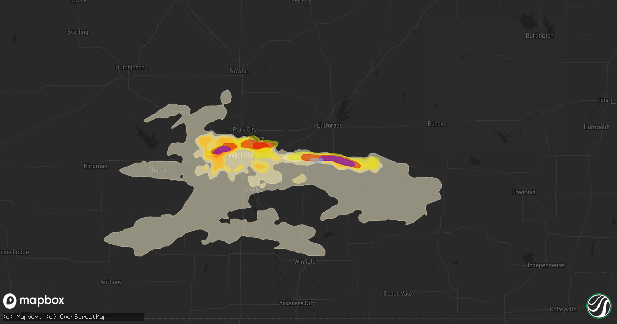
Hail Map in Augusta, KS on June 18, 2019
Get this storm
June 18 map
$229
one time, instant access
Download today. No call, no setup
Keep the $229
Bought the map and want the full workflow? Apply the entire $229 to a subscription within 7 days. None of it is wasted.
Every map, not just this one
This buys you this map. Subscription and you get every map we run, in the markets you choose from a few cities to whole states to nationwide. Plus real-time alerts the moment a storm fires.
Contact data
Name, contact info, occupancy, even credit band for addresses in the footprint. You go from where it hit to who to call.
Become the source they trust
Unlimited branding weather history reports on demand. You already have the documented answer ready for the property owner, and you are the one who showed up with it.
Property data and RoofTrace estimates
Pull up any address you have got, its value and the exact code rules for that jurisdiction, straight from One Click Code. Then RoofTrace estimates the squares, pitch, and roof value, priced the way you price.
Storm reports in Augusta, KS
Augusta, KS
| Date | Description |
|---|---|
| 06/18/20195:21 PM CDT | Estimated 60 to 70 mph wind gusts east of augusta. Semi truck blown over at this location as well. |
| 06/18/20195:20 PM CDT | Semi truck blown over on hwy 54 east of augusta. |
| 06/18/20195:14 PM CDT | . |
All States Impacted by Hail Map on June 18, 2019
All Cities Impacted by Hail Map on June 18, 2019
- Joplin, MT
- Burden, KS
- Post, TX
- Eunice, NM
- Centerville, KS
- Garnett, KS
- Laverne, OK
- Woodward, OK
- Mooreland, OK
- Skellytown, TX
- Borger, TX
- Junction City, KS
- Felt, OK
- Telephone, TX
- Sharon, OK
- Chester, OK
- Wakita, OK
- Fairview, OK
- Erick, OK
- Tishomingo, OK
- Sanderson, TX
- Dryden, TX
- Richmond, KS
- Princeton, KS
- Elk City, KS
- Choctaw, OK
- Newalla, OK
- Mangum, OK
- Atlanta, KS
- Conway Springs, KS
- Courtland, VA
- Yale, VA
- Capron, VA
- Stony Creek, VA
- Gage, OK
- Shattuck, OK
- Okarche, OK
- Butler, OK
- Perryton, TX
- Longview, TX
- Manzanola, CO
- Rocky Ford, CO
- Manchester, OK
- Levelland, TX
- Littlefield, TX
- Anton, TX
- Pampa, TX
- Holly, CO
- Sublette, KS
- Ardmore, OK
- Ashton, ID
- Wellington, KS
- Turon, KS
- Chouteau, OK
- Locust Grove, OK
- Mclean, TX
- Wichita, KS
- Newcastle, TX
- Broken Arrow, OK
- Coweta, OK
- Texola, OK
- Willow, OK
- Sweetwater, OK
- Sayre, OK
- Udall, KS
- Winfield, KS
- Clarendon, TX
- Quail, TX
- Wellington, TX
- Shamrock, TX
- Deer Trail, CO
- Boise City, OK
- Grenville, NM
- Clayton, NM
- Abernathy, TX
- Pittsburg, TX
- Leesburg, TX
- Hamlin, TX
- McCaulley, TX
- Roby, TX
- Belt, MT
- Big Spring, TX
- Panhandle, TX
- Stinnett, TX
- Sunray, TX
- White Deer, TX
- Canon City, CO
- Lawton, OK
- Olney Springs, CO
- Boone, CO
- Fowler, CO
- Catoosa, OK
- Cordell, OK
- Corn, OK
- Colony, OK
- Stafford, KS
- Kingman, KS
- Arlington, KS
- Cunningham, KS
- Foss, OK
- Clinton, OK
- Latham, KS
- Cambridge, KS
- Gracemont, OK
- Havre, MT
- Balmorhea, TX
- Haven, KS
- Sulphur, OK
- Davis, OK
- Muleshoe, TX
- Aurora, CO
- Howard, KS
- Earth, TX
- Sudan, TX
- Medford, OK
- Canyon, TX
- Piedmont, OK
- Fargo, OK
- Fritch, TX
- Groom, TX
- Kevin, MT
- Shelby, MT
- Orange, VA
- Mineral, VA
- Dalhart, TX
- Holmdel, NJ
- Dayton, NJ
- Helmetta, NJ
- Spotswood, NJ
- Monroe Township, NJ
- East Brunswick, NJ
- Colts Neck, NJ
- Morganville, NJ
- Cranbury, NJ
- Monmouth Junction, NJ
- Marlboro, NJ
- Old Bridge, NJ
- Englishtown, NJ
- Bluff City, KS
- Calumet, OK
- Anson, TX
- Abilene, TX
- Saint Anthony, ID
- Rexburg, ID
- Snyder, TX
- Fluvanna, TX
- Crosbyton, TX
- Spur, TX
- Leon, KS
- Augusta, KS
- Hobbs, NM
- Lovington, NM
- Plains, KS
- Roaring Springs, TX
- Floydada, TX
- Hereford, TX
- Hallsville, TX
- Brusett, MT
- Jordan, MT
- Shidler, OK
- Kilgore, TX
- Argonia, KS
- Harper, KS
- Norwich, KS
- Konawa, OK
- Eureka, KS
- El Dorado, KS
- Lockney, TX
- Gretna, VA
- Nathalie, VA
- Java, VA
- Walsenburg, CO
- Elk City, OK
- Hammon, OK
- Canute, OK
- Collinsville, OK
- Skiatook, OK
- Sperry, OK
- Owasso, OK
- Lubbock, TX
- Shallowater, TX
- Wanette, OK
- Wapanucka, OK
- Coleman, OK
- Adrian, TX
- Cheney, KS
- Colorado Springs, CO
- Fountain, CO
- Detroit, TX
- Clarksville, TX
- Kim, CO
- Marathon, TX
- Coalgate, OK
- Clay Center, KS
- Cut Bank, MT
- Hennessey, OK
- Hulbert, OK
- Fort Gibson, OK
- Wagoner, OK
- Paris, TX
- Blossom, TX
- Coahoma, TX
- Bison, OK
- Hydro, OK
- Roswell, NM
- Tatum, TX
- Diana, TX
- Gilmer, TX
- Henderson, TX
- Harleton, TX
- Arapaho, OK
- Pueblo, CO
- Mount Pleasant, TX
- Talco, TX
- Petersburg, TX
- Ralls, TX
- Lorenzo, TX
- Two Dot, MT
- Miami, TX
- Idalou, TX
- Potwin, KS
- Slaton, TX
- Wilson, TX
- Hermleigh, TX
- Decatur, AR
- Woodford, VA
- Ruther Glen, VA
- Altamont, KS
- Carnegie, OK
- Fort Cobb, OK
- Branson, CO
- Picacho, NM
- Otter, MT
- Jetmore, KS
- Burrton, KS
- Halstead, KS
- Sedgwick, KS
- Stratford, TX
- Rose Hill, KS
- Douglass, KS
- Piedmont, KS
- Beulah, CO
- Rye, CO
- Holdenville, OK
- Hennepin, OK
- Tussy, OK
- Ratliff City, OK
- Duncan, OK
- Foster, OK
- Elmore City, OK
- Garden Plain, KS
- Seminole, TX
- Denver City, TX
- Wildorado, TX
- Marietta, OK
- Weatherford, OK
- Sedan, KS
- Cedar Vale, KS
- Mcconnell Afb, KS
- Trinchera, CO
- Trinidad, CO
- Barnsdall, OK
- Burbank, OK
- Pawhuska, OK
- Wynona, OK
- Model, CO
- Kingfisher, OK
- Watonga, OK
- Omega, OK
- Ira, TX
- Andover, KS
- Rock, KS
- Gate, OK
- Ada, OK
- Sasakwa, OK
- Valley Center, KS
- Rotan, TX
- Sweetwater, TX
- Westbrook, TX
- Colorado City, TX
- Sylvester, TX
- Loraine, TX
- Calhan, CO
- Cooper, TX
- Pecos, TX
- Pottsboro, TX
- Newton, KS
- Booker, TX
- Mount Hope, KS
- Alpine, TX
- Sanders, MT
- Clarksville, VA
- Cave Springs, AR
- Gentry, AR
- Springdale, AR
- Siloam Springs, AR
- Bentonville, AR
- Altus, OK
- Blair, OK
- Mountain View, OK
- Gotebo, OK
- Dumas, TX
- Deer Creek, OK
- Nardin, OK
- Blackwell, OK
- Inola, OK
- Hanston, KS
- Spearville, KS
- Vinson, OK
- Gould, OK
- Rush Springs, OK
- Nahunta, GA
- Belle Plaine, KS
- Partlow, VA
- Spotsylvania, VA
- Tahlequah, OK
- Tulsa, OK
- Kaw City, OK
- Claremore, OK
- Crescent, OK
- Wheeler, TX
- Aiken, SC
- Mount Vernon, TX
- Goddard, KS
- Hinton, OK
- Dimmitt, TX
- Nazareth, TX
- Walsh, CO
- Cashion, OK
- Edmond, OK
- Beaverdam, VA
- Louisa, VA
- Bumpass, VA
- Larned, KS
- Kinsley, KS
- Lanexa, VA
- Barhamsville, VA
- Mascot, VA
- West Point, VA
- Shacklefords, VA
- Mattaponi, VA
- Tonkawa, OK
- Billings, OK
- Parker, KS
- Havana, KS
- Paducah, TX
- Longton, KS
- Lexington, OK
- Brookneal, VA
- Randolph, VA
- Charlotte Court House, VA
- Lamesa, TX
- Ponca City, OK
- Red Rock, OK
- Sumner, TX
- Fort Davis, TX
- Tupelo, OK
- Union City, OK
- El Reno, OK
- Clearwater, KS
- Penhook, VA
- Rocky Mount, VA
- Norman, OK
- Maize, KS
- Chinook, MT
- Forsyth, MT
- Riverton, WY
- Espanola, NM
- Hernandez, NM
- Ohkay Owingeh, NM
- Kingston, OK
- Elgin, ND
- Avondale, CO
- Stratford, OK
- Burns, KS
- Minco, OK
- Shawnee, OK
- Byars, OK
- Wayne, OK
- Breckenridge, TX
- Colwich, KS
- Derby, KS
- Rosston, OK
- Great Falls, MT
- Dickens, TX
- Matador, TX
- Clover, VA
- Oklahoma City, OK
- Bethany, OK
- Sugar City, CO
- Cactus, TX
- Vici, OK
- Seiling, OK
- Roxton, TX
- Lake Creek, TX
- Andale, KS
- Ozona, TX
- Dacoma, OK
- Seminole, OK
- Geary, OK
- Brady, MT
- Buffalo, OK
- Meade, KS
- Cyril, OK
- Apache, OK
- New Leipzig, ND
- Plains, TX
- Mcadoo, TX
- Campbell, TX
- Danville, KS
- Dutton, MT
- Aline, OK
- Carmen, OK
- Crowell, TX
- Sherman, TX
- Fort Stockton, TX
- Tecumseh, OK
- Dover, OK
- Little Plymouth, VA
- Church View, VA
- Saluda, VA
- Thomas, OK
- Taloga, OK
- Grenola, KS
- Browns Summit, NC
- Reidsville, NC
- Beaumont, KS
- Murdock, KS
- Viola, KS
- Bentley, KS
- Moline, KS
- Oxford, KS
- Haysville, KS
- Mulvane, KS
- Peck, KS
- Milton, KS
- Big Sandy, TX
- Lookeba, OK
- Bennett, CO
- Oakwood, OK
- Fay, OK
- Okeene, OK
- Waukomis, OK
- Ames, OK
- Brookston, TX
- Arthur City, TX
- Albany, TX
- Las Animas, CO
- Kaufman, TX
- Wynnewood, OK
- Springer, OK
- Durant, OK
- Bokchito, OK
- Earlsboro, OK
- Claude, TX
- Freedom, OK
- Sulphur Bluff, TX
- Elgin, OK
- Fletcher, OK
- Fredonia, KS
- Black Eagle, MT
- Power, MT
- Sand Coulee, MT
- Saltillo, TX
- Cumby, TX
- Texline, TX
- Troy, NC
- New London, NC
- Denton, NC
- Asheboro, NC
- Scroggins, TX
- May, OK
- Pattonville, TX
- Deport, TX
- Neodesha, KS
- Marlow, OK
- Lindsay, OK
- Exmore, VA
- Dallas, TX
- Hutchins, TX
- Mannsville, OK
- Kenefic, OK
- Madill, OK
- Gladewater, TX
- Mountain Park, OK
- Tipton, OK
- Headrick, OK
- Indiahoma, OK
- Snyder, OK
- Chatham, VA
- Bennington, OK
- Lakin, KS
- Odonnell, TX
- Afton, TX
- Mutual, OK
- Anadarko, OK
- Galata, MT
- Fredericksburg, TX
- Binger, OK
- Granite, OK
- Lone Wolf, OK
- Calera, OK
- Mead, OK
- Millstone Township, NJ
- Caddo, OK
- Caney, OK
- Denison, TX
- Midlothian, TX
- Carthage, TX
- Long Branch, TX
- Dike, TX
- Honey Grove, TX
- Bogata, TX
- Fall River, KS
- Purcell, OK
- Cookville, TX
- Florissant, CO
- Independence, KS
- Hollis, OK
- Dewy Rose, GA
- Braman, OK
- Carter, OK
- Rocky, OK
- Hobart, OK
- Arnett, OK
- Pocasset, OK
- Atoka, OK
- Coldwater, KS
- Halifax, VA
- South Boston, VA
- Yukon, OK
- Grandview, TX
- Winona, TX
- Ulysses, KS
- Macomb, OK
- Sylvania, GA
- Conrad, MT
- Peru, KS
- Woodland, NC
- Ahoskie, NC
- Centerton, AR
- Gravette, AR
- Wyandotte, OK
- Windsor, SC
- Stockett, MT
- Follett, TX
- Ore City, TX
- Nassawadox, VA
- Okemah, OK
- Waynoka, OK
- Yoder, CO
- Seagraves, TX
- Ropesville, TX
- Lewis, KS
- Rich Square, NC
- Roxobel, NC
- Scotland Neck, NC
- Wakefield, KS
- Guthrie, OK
- Loving, TX
- Olney, TX
- Omaha, TX
- Freehold, NJ
- Sentinel, OK
- Lone Grove, OK
- Winfield, TX
- Meridian, OK
- Arcadia, OK
- Wolfforth, TX
- Brownfield, TX
- Luray, SC
- Terrell, TX
- Wills Point, TX
- Greenfield, OK
- Pritchett, CO
- Overbrook, OK
- Asher, OK
- Carter, MT
- Floweree, MT
- Newkirk, OK
- Cheyenne, OK
- Trappe, MD
- Hurlock, MD
- Federalsburg, MD
- Preston, MD
- Lincroft, NJ
- Colorado City, CO
- Ninnekah, OK
- Cement, OK
- Fort Sill, OK
- Medicine Park, OK
- Snow, OK
- Nashoba, OK
- Fittstown, OK
- Lamar, OK
- Stuart, OK
- Wardville, OK
- Stringtown, OK
- Clayton, OK
- Roff, OK
- Paoli, OK
- Allen, OK
- Wewoka, OK
- Pauls Valley, OK
- Maud, OK
- Pittsburg, OK
- Mcalester, OK
- Atwood, OK
- Fitzhugh, OK
- Calvin, OK
- Antlers, OK
- Daisy, OK
- Maysville, OK
- Kiowa, OK
- Centrahoma, OK
- Stonewall, OK
- Comanche, OK
- Noble, OK
- Elmer, OK
- Loveland, OK
- Roosevelt, OK
- Grandfield, OK
- Altus Afb, OK
- Duke, OK
- Devol, OK
- Davidson, OK
- Randlett, OK
- Burkburnett, TX
- Olustee, OK
- Wichita Falls, TX
- Temple, OK
- Frederick, OK
- Petrolia, TX
- Byers, TX
- Hollister, OK
- Alma, KS
- Paxico, KS
- Fieldton, TX
- Olton, TX
- Amherst, TX
- Hale Center, TX
- New Deal, TX
- Girard, TX
- Justiceburg, TX
- Seymour, TX
- Avinger, TX
- Lone Star, TX
- Elm Grove, LA
- Marshall, TX
- Haughton, LA
- Shreveport, LA
- Hughes Springs, TX
- Blanchard, LA
- Daingerfield, TX
- Mooringsport, LA
- Mansfield, LA
- Jefferson, TX
- Karnack, TX
- Barksdale Afb, LA
- Linden, TX
- Bossier City, LA
- Frierson, LA
- Vivian, LA
- Greenwood, LA
- White Oak, TX
- Hawkins, TX
- Waskom, TX
- Bridgeville, DE
- Seaford, DE
- Greenwood, DE
- Marfa, TX


