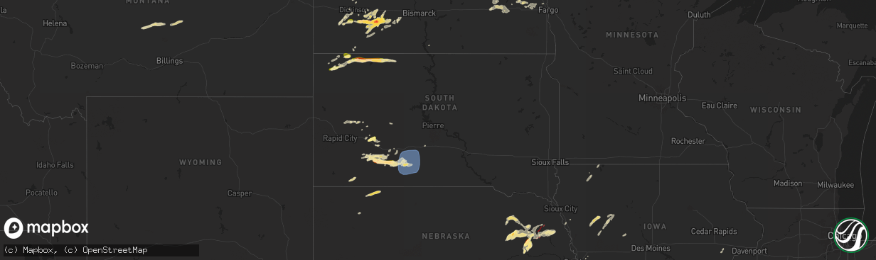
Hail Map in South Dakota on June 15, 2024
The weather event in South Dakota on June 15, 2024 includes Wind, Hail, and Tornado maps. 16 states and 625 cities were impacted and suffered possible damage. The total estimated number of properties impacted is 1,289.
Want more than just the map?
Turn this storm into a full workflow.
- Owner + property data so you know who to knock
- OnDemand branded weather history reports to win the "did we even have hail?" argument
- RoofTrace estimate so reps stop guessing numbers at the door
Bought this map? Upgrade within 7 days and we'll credit the $230. (10-15 min setup call)
Wind
Hail
Tornado
1,289
Estimated number of impacted properties by a 1.00" hail or larger479
Estimated number of impacted properties by a 1.75" hail or larger0
Estimated number of impacted properties by a 2.50" hail or largerStorm reports in South Dakota
South Dakota
| Date | Description |
|---|---|
| 06/15/20246:45 PM CDT | A local report indicates 59 MPH wind near Wasta |
| 06/15/20246:33 PM CDT | A local report indicates 60 MPH wind near 3 WSW Fairburn |
| 06/15/20246:25 PM CDT | A local report indicates 61 MPH wind near 7 W Ardmore |
| 06/14/202411:26 PM CDT | A local report indicates 67 MPH wind near 1 N Buffalo |
| 06/14/202410:59 PM CDT | Mesonet station rfps2 vivian 13 n. |
| 06/14/202410:25 PM CDT | Mesonet station 13 vivian |
| 06/14/20249:40 PM CDT | A local report indicates 60 MPH wind near 1 ESE Martin |
| 06/14/20249:35 PM CDT | A local report indicates 65 MPH wind near 4 WNW Cedar Butte |
| 06/14/20249:30 PM CDT | A local report indicates 62 MPH wind near 4 WNW Cedar Butte |
| 06/14/20249:28 PM CDT | A local report indicates 64 MPH wind near 6 W Parmelee |
| 06/14/20249:20 PM CDT | A local report indicates 1.00 inch wind near Lodgepole |
| 06/14/20249:00 PM CDT | A local report indicates 60 MPH wind near 5 SSE Belvidere |
| 06/14/20248:41 PM CDT | A local report indicates 65 MPH wind near 5 NE Porcupine |
| 06/14/20248:40 PM CDT | Hail estimated between 1.25 and 1.75 inches in diameter |
| 06/14/20248:15 PM CDT | A local report indicates 1.25 inch wind near 7 NE Ralph |
| 06/14/20247:16 PM CDT | Mostly small hail |
| 06/14/20247:15 PM CDT | A local report indicates 67 MPH wind near 4 NNE Angostura Res |
| 06/14/20247:07 PM CDT | Piles and drifts of small hail less than quarter size |
| 06/14/20247:06 PM CDT | Mping report |
All States Impacted by Hail Map on June 15, 2024
Cities Impacted by Hail Map on June 15, 2024
- Birmingham, IA
- Fairfield, IA
- Stockport, IA
- Hillsboro, IA
- Donnellson, IA
- Salem, IA
- West Point, IA
- Highwood, MT
- Fort Benton, MT
- Nickerson, KS
- Abbyville, KS
- Conway, SC
- Partridge, KS
- Loris, SC
- Longs, SC
- Winter Garden, FL
- Clermont, FL
- Lyons, KS
- Little River, KS
- Republic, KS
- Sterling, KS
- Hutchinson, KS
- Byron, NE
- South Hutchinson, KS
- Ocala, FL
- Windermere, FL
- Oakland, FL
- Wildwood, FL
- The Villages, FL
- Hilger, MT
- Lloyd, MT
- Deshler, NE
- Fruitland Park, FL
- Leesburg, FL
- Lewistown, MT
- Denton, MT
- Yalaha, FL
- Lindsborg, KS
- Salina, KS
- Winifred, MT
- Hebron, NE
- Belleville, KS
- Buhler, KS
- Burrton, KS
- New Cambria, KS
- Belvidere, NE
- Clearwater, NE
- Chester, NE
- Hay Springs, NE
- Ingalls, KS
- Solomon, KS
- Stanton, ND
- Hazen, ND
- Lake City, SC
- Neligh, NE
- Hubbell, NE
- Munden, KS
- Petersburg, NE
- Albion, NE
- Dunnellon, FL
- Cimarron, KS
- Hope, KS
- Abilene, KS
- Gypsum, KS
- Enterprise, KS
- Gilead, NE
- Fairbury, NE
- Alexandria, NE
- Daykin, NE
- Amidon, ND
- New England, ND
- Scranton, SC
- Zortman, MT
- Swanton, NE
- Western, NE
- Plymouth, NE
- Wilber, NE
- Herington, KS
- Chapman, KS
- Woodbine, KS
- Morrowville, KS
- Washington, KS
- Plainview, NE
- Brunswick, NE
- Ryegate, MT
- Lavina, MT
- Tilden, NE
- Micanopy, FL
- De Witt, NE
- Wakefield, KS
- Clay Center, KS
- Junction City, KS
- Minneapolis, KS
- Newman Grove, NE
- Longford, KS
- Tobias, NE
- Belfield, ND
- Ness City, KS
- Meadow Grove, NE
- Green, KS
- Roundup, MT
- Hollenberg, KS
- White City, KS
- Platte Center, NE
- Creston, NE
- Columbus, NE
- South Heart, ND
- Greenleaf, KS
- Bazine, KS
- Odell, NE
- Diller, NE
- Ransom, KS
- Brownell, KS
- Fort Riley, KS
- Riley, KS
- Milford, KS
- Dwight, KS
- Manhattan, KS
- Olsburg, KS
- Ogden, KS
- Leonardville, KS
- Randolph, KS
- Westmoreland, KS
- Humphrey, NE
- Meade, KS
- Gate, OK
- Monroe, NE
- Norfolk, NE
- Madison, NE
- Wymore, NE
- Blue Springs, NE
- Steele City, NE
- Leigh, NE
- Saint George, KS
- Englewood, KS
- Jetmore, KS
- Dodge City, KS
- Battle Creek, NE
- Churchs Ferry, ND
- Cando, ND
- Pierce, NE
- Beatrice, NE
- Endicott, NE
- Hoskins, NE
- McCracken, KS
- Canadian, TX
- Osmond, NE
- Andrews, SC
- Stanton, NE
- Onaga, KS
- Starkweather, ND
- Forgan, OK
- Fort Peck, MT
- Lindsay, NE
- Wisner, NE
- Pilger, NE
- Wall, SD
- Unadilla, NE
- Palmyra, NE
- Weeping Water, NE
- Eagle, NE
- Murdock, NE
- Elmwood, NE
- Sturgis, SD
- Minneola, KS
- Burns, WY
- Cheyenne, WY
- Virginia, NE
- Miami, TX
- Hanover, KS
- Clarkson, NE
- Quinn, SD
- Buffalo, SD
- Corning, KS
- Havensville, KS
- Goff, KS
- Humboldt, NE
- Seneca, KS
- Du Bois, NE
- Frankfort, KS
- Oneida, KS
- Bern, KS
- Centralia, KS
- Baileyville, KS
- Table Rock, NE
- Pawnee City, NE
- Axtell, KS
- Vermillion, KS
- Marysville, KS
- Waterville, KS
- Blue Rapids, KS
- Beattie, KS
- Home, KS
- Summerfield, KS
- Burchard, NE
- Mullinville, KS
- Wayne, NE
- Pine Bluffs, WY
- New Underwood, SD
- Lewiston, NE
- Manley, NE
- Louisville, NE
- Howells, NE
- Durham, OK
- Quanah, TX
- Sweetwater, OK
- Reydon, OK
- Crowell, TX
- Seymour, TX
- Abilene, TX
- Rosston, OK
- Haskell, TX
- Laverne, OK
- Gould, OK
- Munday, TX
- Lueders, TX
- Weinert, TX
- Cheyenne, OK
- Erick, OK
- Mangum, OK
- Clyde, TX
- Eldorado, OK
- Shattuck, OK
- Stamford, TX
- Vinson, OK
- Coleman, TX
- Arnett, OK
- Sayre, OK
- Nashua, MT
- Coyanosa, TX
- Glasgow, MT
- Kingstree, SC
- Walton, NE
- Lincoln, NE
- Haven, KS
- Pretty Prairie, KS
- Marathon, TX
- Wetmore, KS
- Sabetha, KS
- Dawson, NE
- Morrill, KS
- Fairview, KS
- Salem, NE
- Verdon, NE
- Peru, NE
- Stella, NE
- Nemaha, NE
- Auburn, NE
- Shubert, NE
- Brownville, NE
- Wright, KS
- Hampden, ND
- Beemer, NE
- Fowler, KS
- Haviland, KS
- Kyle, SD
- Alsen, ND
- Netawaka, KS
- Powhattan, KS
- Rock Port, MO
- Falls City, NE
- Fairfax, MO
- Hiawatha, KS
- Craig, MO
- Watson, MO
- Regent, ND
- Lefor, ND
- Plattsmouth, NE
- Thurman, IA
- Hamburg, IA
- Sidney, IA
- Nebraska City, NE
- Percival, IA
- Pacific Junction, IA
- Nehawka, NE
- Syracuse, NE
- Dunbar, NE
- Union, NE
- Elk Creek, NE
- Cook, NE
- Brock, NE
- Tecumseh, NE
- Avoca, NE
- Murray, NE
- Johnson, NE
- Otoe, NE
- Julian, NE
- Sterling, NE
- Talmage, NE
- Steinauer, NE
- Lorton, NE
- Frazer, MT
- Enning, SD
- Pine Ridge, SD
- Gordon, NE
- Crab Orchard, NE
- Wanblee, SD
- Oglala, SD
- Wolf Point, MT
- Mott, ND
- Shenandoah, IA
- Northboro, IA
- Essex, IA
- Tarkio, MO
- Farragut, IA
- Red Oak, IA
- Coin, IA
- Riverton, IA
- Westboro, MO
- Imogene, IA
- Malvern, IA
- Randolph, IA
- Emerson, IA
- Glenwood, IA
- Tabor, IA
- Hastings, IA
- Bellevue, NE
- Council Bluffs, IA
- Silver City, IA
- Elmo, MO
- Blanchard, IA
- Rulo, NE
- Horton, KS
- Mound City, MO
- Whiting, KS
- Spearville, KS
- Langdon, ND
- Hanston, KS
- West Point, NE
- Bancroft, NE
- Plains, TX
- Levelland, TX
- Ralph, SD
- Circle, MT
- Hartley, IA
- Primghar, IA
- Liberty, NE
- Filley, NE
- Lodgepole, SD
- Skidmore, MO
- White Cloud, KS
- Maitland, MO
- Burlington Junction, MO
- Clarinda, IA
- Dickinson, ND
- Osnabrock, ND
- Macy, NE
- Decatur, NE
- Minden, IA
- McClelland, IA
- Underwood, IA
- Burdett, KS
- Poplar, MT
- Jordan, MT
- Cohagen, MT
- Vida, MT
- Brockway, MT
- Bloomfield, MT
- Richey, MT
- Lambert, MT
- Brockton, MT
- Richardton, ND
- Brownfield, TX
- Rozel, KS
- Sloan, IA
- Whiting, IA
- Walhalla, ND
- Lyons, NE
- Glendive, MT
- Savage, MT
- Fairview, MT
- Culbertson, MT
- Froid, MT
- Fort Stockton, TX
- Denver City, TX
- Hornick, IA
- Long Valley, SD
- Hebron, ND
- New Leipzig, ND
- Alexander, KS
- Lindsay, MT
- Carpenter, WY
- Lathrop, MO
- Ropesville, TX
- Meadow, TX
- Larned, KS
- Lemmon, SD
- Glen Ullin, ND
- Sidney, MT
- Crane, MT
- Bainville, MT
- Scandia, KS
- Courtland, KS
- Sanborn, IA
- Whiteface, TX
- Soldier, KS
- Loop, TX
- Lake Park, IA
- Sundown, TX
- Maryville, MO
- Spirit Lake, IA
- Graham, MO
- Seagraves, TX
- White River, SD
- Parmelee, SD
- Saint Francis, SD
- Norris, SD
- Okaton, SD
- Martin, SD
- Murdo, SD
- Cartwright, ND
- Grassy Butte, ND
- Williston, ND
- Alexander, ND
- Trenton, ND
- Woodrow, CO
- Otis, CO
- Yuma, CO
- Cope, CO
- Lindon, CO
- Anton, CO
- Akron, CO
- Brush, CO
- Offerle, KS
- Kinsley, KS
- Almont, ND
- Keldron, SD
- Kit Carson, CO
- Seminole, TX
- Watford City, ND
- Ray, ND
- Tioga, ND
- Arnegard, ND
- Epping, ND
- Wildrose, ND
- Alamo, ND
- Bennington, KS
- Ludlow, SD
- Scenic, SD
- Rushville, NE
- Morristown, SD
- Miltonvale, KS
- Mantorville, MN
- West Concord, MN
- Mcgregor, ND
- Reva, SD
- Merriman, NE
- White Earth, ND
- Crosby, ND
- Clyde, KS
- Concordia, KS
- Dagmar, MT
- Stanley, ND
- Powers Lake, ND
- Ross, ND
- Wasta, SD
- Pine Island, MN
- Bucklin, KS
- Keene, ND
- Noonan, ND
- Columbus, ND
- Ambrose, ND
- Lamesa, TX
- Tarzan, TX
- Zahl, ND
- Grenora, ND
- Lignite, ND
- Portal, ND
- Prairie City, SD
- Hettinger, ND
- Kenmare, ND
- Palermo, ND
- Mandaree, ND
- New Town, ND
- Killdeer, ND
- Morganville, KS
- Clifton, KS
- Bowbells, ND
- Agenda, KS
- Clearmont, MO
- Donnybrook, ND
- Palmer, KS
- Linn, KS
- Tolley, ND
- Manning, ND
- Berthold, ND
- Stanton, TX
- Plaza, ND
- Parshall, ND
- Roseglen, ND
- Lenorah, TX
- Taylor, ND
- Gladstone, ND
- Maxbass, ND
- Mohall, ND
- Fleming, CO
- Carpio, ND
- Burlington, ND
- Des Lacs, ND
- Makoti, ND
- Ryder, ND
- Minot, ND
- Minot Afb, ND
- Lansford, ND
- Glenburn, ND
- Surrey, ND
- Norwich, ND
- Deering, ND
- Newburg, ND
- Upham, ND
- Westhope, ND
- Owanka, SD
- Dodge, ND
- Halliday, ND
- Haddam, KS
- Manilla, IA
- Roswell, NM
- Kadoka, SD
- Eckley, CO
- Midland, SD
- Milesville, SD
- Interior, SD
- Golden Valley, ND
- Zap, ND
- Dunn Center, ND
- Beulah, ND
- Granville, ND
- Bantry, ND
- Souris, ND
- Kramer, ND
- Haxtun, CO
- Delphos, KS
- Philip, SD
- Schleswig, IA
- Riverdale, ND
- Underwood, ND
- Coleharbor, ND
- Ida Grove, IA
- Kiron, IA
- Denison, IA
- Norway, KS
- Jamestown, KS
- Bagley, IA
- Barnes, KS
- Elgin, ND
- Odebolt, IA
- Arcadia, IA
- Carroll, IA
- Breda, IA
- Cuba, KS
- Westside, IA
- Elida, NM
- Auburn, IA
- Birmingham, AL
- Fairfield, AL
- Lake City, IA
- Watauga, SD
- Tokio, TX
- Narka, KS
- Mahaska, KS
- Lake View, IA
- Alta Vista, KS
- Charter Oak, IA
- Jefferson, IA
- Alma, KS
- Arthur, IA
- Wall Lake, IA
- Strasburg, ND
- Sac City, IA
- Rockwell City, IA
- Lytton, IA
- Scott City, KS
- New Salem, ND
- Carson, ND
- Fairdale, ND
- Jamestown, ND
- Sanborn, ND
- Spiritwood, ND
- Arapaho, OK
- Tampa, KS
- Ramona, KS
- Lone Tree, IA
- Lost Springs, KS
- Durham, KS
- Rocky, OK
- Valley City, ND
- Dazey, ND
- Wimbledon, ND
- Sarles, ND
- Hannaford, ND
- Cooperstown, ND
- Wamego, KS
- Marion, KS
- Talmage, KS
- Sentinel, OK
- Dill City, OK
- Cordell, OK
- Custer City, OK
- Taloga, OK
- Corn, OK
- Clinton, OK
- Courtenay, ND
- Winona, KS
- Hobart, OK
- Gotebo, OK
- Ayr, ND
- Buffalo, ND
- Tower City, ND
- Wheatland, ND
- Casselton, ND
- Amenia, ND
- Galva, KS
- Finley, ND
- Luverne, ND
- Putnam, OK
- Canton, KS
- Harwood, ND
- Lehigh, KS
- Hillsboro, KS
- Mchenry, ND
- Sherwood, ND
- Rugby, ND
- Edmore, ND
- Butler, OK
- Foss, OK


