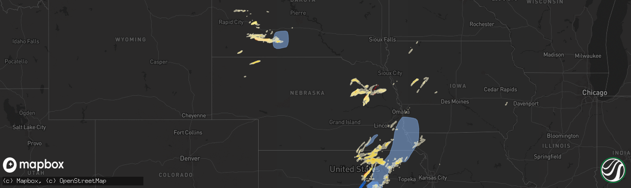
Hail Map in Nebraska on June 15, 2024
The weather event in Nebraska on June 15, 2024 includes Wind, Hail, and Tornado maps. 16 states and 625 cities were impacted and suffered possible damage. The total estimated number of properties impacted is 1,774.
Want more than just the map?
Turn this storm into a full workflow.
- Owner + property data so you know who to knock
- OnDemand branded weather history reports to win the "did we even have hail?" argument
- RoofTrace estimate so reps stop guessing numbers at the door
Bought this map? Upgrade within 7 days and we'll credit the $230. (10-15 min setup call)
Wind
Hail
Tornado
1,774
Estimated number of impacted properties by a 1.00" hail or larger764
Estimated number of impacted properties by a 1.75" hail or larger0
Estimated number of impacted properties by a 2.50" hail or largerStorm reports in Nebraska
Nebraska
| Date | Description |
|---|---|
| 06/15/20246:58 PM CDT | A local report indicates a tornado near 4 NE Pilger |
| 06/15/20246:56 PM CDT | Ef-0. Nws in collaboration with stanton county emergency management confirmed a tornado damage path that began at this location. Documented from storm chaser video... T |
| 06/15/20246:55 PM CDT | Report from mping: 1-inch tree limbs broken; shingles blown off. |
| 06/15/20246:45 PM CDT | Approximately a 5 mile long by 2 mile wide swath of hail with up to golfball size observed. |
| 06/15/20246:37 PM CDT | Ef-0. Nws in collaboration with stanton county emergency management confirmed that a tornado occurred at this location. This was a very brief tornado caused window dama |
| 06/15/20246:14 PM CDT | Photo evidence and eyewitness reports of a funnel cloud with a short-lived ground circulation and dust cloud. Brief tornado at this location. |
| 06/15/20245:50 PM CDT | A local report indicates a tornado near 4 SSW Battle Creek |
| 06/15/20245:28 PM CDT | A local report indicates a tornado near 10 S Tilden |
| 06/15/20244:47 PM CDT | Mesonet recorded a gust of 58 mph. |
| 06/14/20248:28 PM CDT | Report from mping: 1-inch tree limbs broken; shingles blown off. |
| 06/14/20248:15 PM CDT | At the airport. |
| 06/14/20247:56 PM CDT | Public weather station measured gust. |
| 06/14/20247:45 PM CDT | Report from mping: 1-inch tree limbs broken; shingles blown off. |
| 06/14/20247:31 PM CDT | A local report indicates 69 MPH wind near 3 SW Nemaha |
| 06/14/20247:28 PM CDT | A local report indicates a tornado near 8 N Howells |
| 06/14/20247:21 PM CDT | A local report indicates a tornado near 3 W Pender |
| 06/14/20247:16 PM CDT | A local report indicates a tornado near 7 NNE Clarkson |
| 06/14/20247:13 PM CDT | A local report indicates 60 MPH wind near 3 W Plattsmouth |
| 06/14/20247:10 PM CDT | A local report indicates a tornado near 5 N Clarkson |
| 06/14/20247:09 PM CDT | Personal weather station measured gust. |
| 06/14/20247:07 PM CDT | A local report indicates 60 MPH wind near 3 E Johnson |
| 06/14/20247:07 PM CDT | A local report indicates a tornado near 4 N Clarkson |
| 06/14/20247:07 PM CDT | Photo of brief tornado at this location. Watched the tornado travel for approximately a half mile. No damage. |
| 06/14/20247:06 PM CDT | Ef-1. Nws in coordination with stanton county emergency management concluded that an ef-1 tornado began at this location. Based on chaser video as well as drone footage |
All States Impacted by Hail Map on June 15, 2024
Cities Impacted by Hail Map on June 15, 2024
- Birmingham, IA
- Fairfield, IA
- Stockport, IA
- Hillsboro, IA
- Donnellson, IA
- Salem, IA
- West Point, IA
- Highwood, MT
- Fort Benton, MT
- Nickerson, KS
- Abbyville, KS
- Conway, SC
- Partridge, KS
- Loris, SC
- Longs, SC
- Winter Garden, FL
- Clermont, FL
- Lyons, KS
- Little River, KS
- Republic, KS
- Sterling, KS
- Hutchinson, KS
- Byron, NE
- South Hutchinson, KS
- Ocala, FL
- Windermere, FL
- Oakland, FL
- Wildwood, FL
- The Villages, FL
- Hilger, MT
- Lloyd, MT
- Deshler, NE
- Fruitland Park, FL
- Leesburg, FL
- Lewistown, MT
- Denton, MT
- Yalaha, FL
- Lindsborg, KS
- Salina, KS
- Winifred, MT
- Hebron, NE
- Belleville, KS
- Buhler, KS
- Burrton, KS
- New Cambria, KS
- Belvidere, NE
- Clearwater, NE
- Chester, NE
- Hay Springs, NE
- Ingalls, KS
- Solomon, KS
- Stanton, ND
- Hazen, ND
- Lake City, SC
- Neligh, NE
- Hubbell, NE
- Munden, KS
- Petersburg, NE
- Albion, NE
- Dunnellon, FL
- Cimarron, KS
- Hope, KS
- Abilene, KS
- Gypsum, KS
- Enterprise, KS
- Gilead, NE
- Fairbury, NE
- Alexandria, NE
- Daykin, NE
- Amidon, ND
- New England, ND
- Scranton, SC
- Zortman, MT
- Swanton, NE
- Western, NE
- Plymouth, NE
- Wilber, NE
- Herington, KS
- Chapman, KS
- Woodbine, KS
- Morrowville, KS
- Washington, KS
- Plainview, NE
- Brunswick, NE
- Ryegate, MT
- Lavina, MT
- Tilden, NE
- Micanopy, FL
- De Witt, NE
- Wakefield, KS
- Clay Center, KS
- Junction City, KS
- Minneapolis, KS
- Newman Grove, NE
- Longford, KS
- Tobias, NE
- Belfield, ND
- Ness City, KS
- Meadow Grove, NE
- Green, KS
- Roundup, MT
- Hollenberg, KS
- White City, KS
- Platte Center, NE
- Creston, NE
- Columbus, NE
- South Heart, ND
- Greenleaf, KS
- Bazine, KS
- Odell, NE
- Diller, NE
- Ransom, KS
- Brownell, KS
- Fort Riley, KS
- Riley, KS
- Milford, KS
- Dwight, KS
- Manhattan, KS
- Olsburg, KS
- Ogden, KS
- Leonardville, KS
- Randolph, KS
- Westmoreland, KS
- Humphrey, NE
- Meade, KS
- Gate, OK
- Monroe, NE
- Norfolk, NE
- Madison, NE
- Wymore, NE
- Blue Springs, NE
- Steele City, NE
- Leigh, NE
- Saint George, KS
- Englewood, KS
- Jetmore, KS
- Dodge City, KS
- Battle Creek, NE
- Churchs Ferry, ND
- Cando, ND
- Pierce, NE
- Beatrice, NE
- Endicott, NE
- Hoskins, NE
- McCracken, KS
- Canadian, TX
- Osmond, NE
- Andrews, SC
- Stanton, NE
- Onaga, KS
- Starkweather, ND
- Forgan, OK
- Fort Peck, MT
- Lindsay, NE
- Wisner, NE
- Pilger, NE
- Wall, SD
- Unadilla, NE
- Palmyra, NE
- Weeping Water, NE
- Eagle, NE
- Murdock, NE
- Elmwood, NE
- Sturgis, SD
- Minneola, KS
- Burns, WY
- Cheyenne, WY
- Virginia, NE
- Miami, TX
- Hanover, KS
- Clarkson, NE
- Quinn, SD
- Buffalo, SD
- Corning, KS
- Havensville, KS
- Goff, KS
- Humboldt, NE
- Seneca, KS
- Du Bois, NE
- Frankfort, KS
- Oneida, KS
- Bern, KS
- Centralia, KS
- Baileyville, KS
- Table Rock, NE
- Pawnee City, NE
- Axtell, KS
- Vermillion, KS
- Marysville, KS
- Waterville, KS
- Blue Rapids, KS
- Beattie, KS
- Home, KS
- Summerfield, KS
- Burchard, NE
- Mullinville, KS
- Wayne, NE
- Pine Bluffs, WY
- New Underwood, SD
- Lewiston, NE
- Manley, NE
- Louisville, NE
- Howells, NE
- Durham, OK
- Quanah, TX
- Sweetwater, OK
- Reydon, OK
- Crowell, TX
- Seymour, TX
- Abilene, TX
- Rosston, OK
- Haskell, TX
- Laverne, OK
- Gould, OK
- Munday, TX
- Lueders, TX
- Weinert, TX
- Cheyenne, OK
- Erick, OK
- Mangum, OK
- Clyde, TX
- Eldorado, OK
- Shattuck, OK
- Stamford, TX
- Vinson, OK
- Coleman, TX
- Arnett, OK
- Sayre, OK
- Nashua, MT
- Coyanosa, TX
- Glasgow, MT
- Kingstree, SC
- Walton, NE
- Lincoln, NE
- Haven, KS
- Pretty Prairie, KS
- Marathon, TX
- Wetmore, KS
- Sabetha, KS
- Dawson, NE
- Morrill, KS
- Fairview, KS
- Salem, NE
- Verdon, NE
- Peru, NE
- Stella, NE
- Nemaha, NE
- Auburn, NE
- Shubert, NE
- Brownville, NE
- Wright, KS
- Hampden, ND
- Beemer, NE
- Fowler, KS
- Haviland, KS
- Kyle, SD
- Alsen, ND
- Netawaka, KS
- Powhattan, KS
- Rock Port, MO
- Falls City, NE
- Fairfax, MO
- Hiawatha, KS
- Craig, MO
- Watson, MO
- Regent, ND
- Lefor, ND
- Plattsmouth, NE
- Thurman, IA
- Hamburg, IA
- Sidney, IA
- Nebraska City, NE
- Percival, IA
- Pacific Junction, IA
- Nehawka, NE
- Syracuse, NE
- Dunbar, NE
- Union, NE
- Elk Creek, NE
- Cook, NE
- Brock, NE
- Tecumseh, NE
- Avoca, NE
- Murray, NE
- Johnson, NE
- Otoe, NE
- Julian, NE
- Sterling, NE
- Talmage, NE
- Steinauer, NE
- Lorton, NE
- Frazer, MT
- Enning, SD
- Pine Ridge, SD
- Gordon, NE
- Crab Orchard, NE
- Wanblee, SD
- Oglala, SD
- Wolf Point, MT
- Mott, ND
- Shenandoah, IA
- Northboro, IA
- Essex, IA
- Tarkio, MO
- Farragut, IA
- Red Oak, IA
- Coin, IA
- Riverton, IA
- Westboro, MO
- Imogene, IA
- Malvern, IA
- Randolph, IA
- Emerson, IA
- Glenwood, IA
- Tabor, IA
- Hastings, IA
- Bellevue, NE
- Council Bluffs, IA
- Silver City, IA
- Elmo, MO
- Blanchard, IA
- Rulo, NE
- Horton, KS
- Mound City, MO
- Whiting, KS
- Spearville, KS
- Langdon, ND
- Hanston, KS
- West Point, NE
- Bancroft, NE
- Plains, TX
- Levelland, TX
- Ralph, SD
- Circle, MT
- Hartley, IA
- Primghar, IA
- Liberty, NE
- Filley, NE
- Lodgepole, SD
- Skidmore, MO
- White Cloud, KS
- Maitland, MO
- Burlington Junction, MO
- Clarinda, IA
- Dickinson, ND
- Osnabrock, ND
- Macy, NE
- Decatur, NE
- Minden, IA
- McClelland, IA
- Underwood, IA
- Burdett, KS
- Poplar, MT
- Jordan, MT
- Cohagen, MT
- Vida, MT
- Brockway, MT
- Bloomfield, MT
- Richey, MT
- Lambert, MT
- Brockton, MT
- Richardton, ND
- Brownfield, TX
- Rozel, KS
- Sloan, IA
- Whiting, IA
- Walhalla, ND
- Lyons, NE
- Glendive, MT
- Savage, MT
- Fairview, MT
- Culbertson, MT
- Froid, MT
- Fort Stockton, TX
- Denver City, TX
- Hornick, IA
- Long Valley, SD
- Hebron, ND
- New Leipzig, ND
- Alexander, KS
- Lindsay, MT
- Carpenter, WY
- Lathrop, MO
- Ropesville, TX
- Meadow, TX
- Larned, KS
- Lemmon, SD
- Glen Ullin, ND
- Sidney, MT
- Crane, MT
- Bainville, MT
- Scandia, KS
- Courtland, KS
- Sanborn, IA
- Whiteface, TX
- Soldier, KS
- Loop, TX
- Lake Park, IA
- Sundown, TX
- Maryville, MO
- Spirit Lake, IA
- Graham, MO
- Seagraves, TX
- White River, SD
- Parmelee, SD
- Saint Francis, SD
- Norris, SD
- Okaton, SD
- Martin, SD
- Murdo, SD
- Cartwright, ND
- Grassy Butte, ND
- Williston, ND
- Alexander, ND
- Trenton, ND
- Woodrow, CO
- Otis, CO
- Yuma, CO
- Cope, CO
- Lindon, CO
- Anton, CO
- Akron, CO
- Brush, CO
- Offerle, KS
- Kinsley, KS
- Almont, ND
- Keldron, SD
- Kit Carson, CO
- Seminole, TX
- Watford City, ND
- Ray, ND
- Tioga, ND
- Arnegard, ND
- Epping, ND
- Wildrose, ND
- Alamo, ND
- Bennington, KS
- Ludlow, SD
- Scenic, SD
- Rushville, NE
- Morristown, SD
- Miltonvale, KS
- Mantorville, MN
- West Concord, MN
- Mcgregor, ND
- Reva, SD
- Merriman, NE
- White Earth, ND
- Crosby, ND
- Clyde, KS
- Concordia, KS
- Dagmar, MT
- Stanley, ND
- Powers Lake, ND
- Ross, ND
- Wasta, SD
- Pine Island, MN
- Bucklin, KS
- Keene, ND
- Noonan, ND
- Columbus, ND
- Ambrose, ND
- Lamesa, TX
- Tarzan, TX
- Zahl, ND
- Grenora, ND
- Lignite, ND
- Portal, ND
- Prairie City, SD
- Hettinger, ND
- Kenmare, ND
- Palermo, ND
- Mandaree, ND
- New Town, ND
- Killdeer, ND
- Morganville, KS
- Clifton, KS
- Bowbells, ND
- Agenda, KS
- Clearmont, MO
- Donnybrook, ND
- Palmer, KS
- Linn, KS
- Tolley, ND
- Manning, ND
- Berthold, ND
- Stanton, TX
- Plaza, ND
- Parshall, ND
- Roseglen, ND
- Lenorah, TX
- Taylor, ND
- Gladstone, ND
- Maxbass, ND
- Mohall, ND
- Fleming, CO
- Carpio, ND
- Burlington, ND
- Des Lacs, ND
- Makoti, ND
- Ryder, ND
- Minot, ND
- Minot Afb, ND
- Lansford, ND
- Glenburn, ND
- Surrey, ND
- Norwich, ND
- Deering, ND
- Newburg, ND
- Upham, ND
- Westhope, ND
- Owanka, SD
- Dodge, ND
- Halliday, ND
- Haddam, KS
- Manilla, IA
- Roswell, NM
- Kadoka, SD
- Eckley, CO
- Midland, SD
- Milesville, SD
- Interior, SD
- Golden Valley, ND
- Zap, ND
- Dunn Center, ND
- Beulah, ND
- Granville, ND
- Bantry, ND
- Souris, ND
- Kramer, ND
- Haxtun, CO
- Delphos, KS
- Philip, SD
- Schleswig, IA
- Riverdale, ND
- Underwood, ND
- Coleharbor, ND
- Ida Grove, IA
- Kiron, IA
- Denison, IA
- Norway, KS
- Jamestown, KS
- Bagley, IA
- Barnes, KS
- Elgin, ND
- Odebolt, IA
- Arcadia, IA
- Carroll, IA
- Breda, IA
- Cuba, KS
- Westside, IA
- Elida, NM
- Auburn, IA
- Birmingham, AL
- Fairfield, AL
- Lake City, IA
- Watauga, SD
- Tokio, TX
- Narka, KS
- Mahaska, KS
- Lake View, IA
- Alta Vista, KS
- Charter Oak, IA
- Jefferson, IA
- Alma, KS
- Arthur, IA
- Wall Lake, IA
- Strasburg, ND
- Sac City, IA
- Rockwell City, IA
- Lytton, IA
- Scott City, KS
- New Salem, ND
- Carson, ND
- Fairdale, ND
- Jamestown, ND
- Sanborn, ND
- Spiritwood, ND
- Arapaho, OK
- Tampa, KS
- Ramona, KS
- Lone Tree, IA
- Lost Springs, KS
- Durham, KS
- Rocky, OK
- Valley City, ND
- Dazey, ND
- Wimbledon, ND
- Sarles, ND
- Hannaford, ND
- Cooperstown, ND
- Wamego, KS
- Marion, KS
- Talmage, KS
- Sentinel, OK
- Dill City, OK
- Cordell, OK
- Custer City, OK
- Taloga, OK
- Corn, OK
- Clinton, OK
- Courtenay, ND
- Winona, KS
- Hobart, OK
- Gotebo, OK
- Ayr, ND
- Buffalo, ND
- Tower City, ND
- Wheatland, ND
- Casselton, ND
- Amenia, ND
- Galva, KS
- Finley, ND
- Luverne, ND
- Putnam, OK
- Canton, KS
- Harwood, ND
- Lehigh, KS
- Hillsboro, KS
- Mchenry, ND
- Sherwood, ND
- Rugby, ND
- Edmore, ND
- Butler, OK
- Foss, OK


