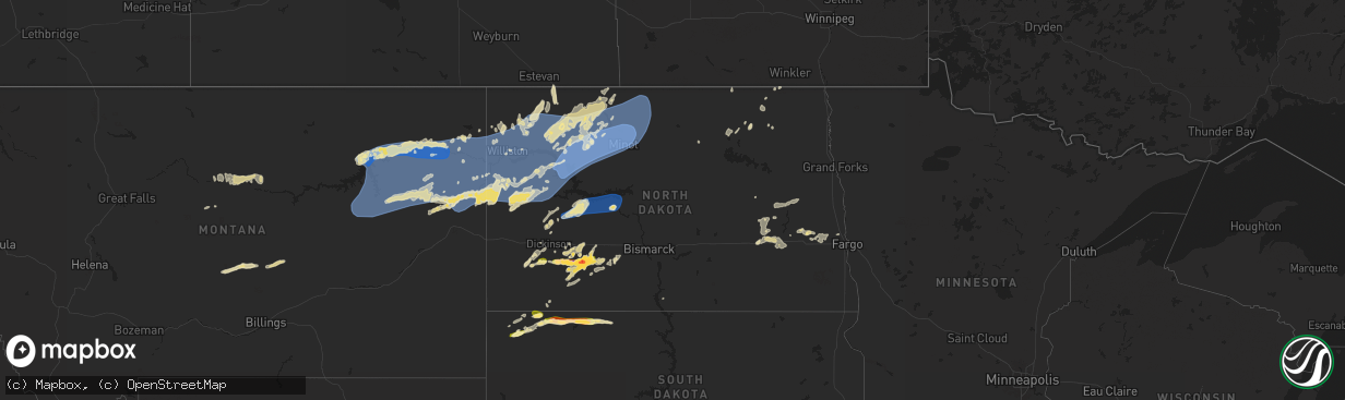
Hail Map in North Dakota on June 15, 2024
The weather event in North Dakota on June 15, 2024 includes Wind, Hail, and Tornado maps. 16 states and 625 cities were impacted and suffered possible damage. The total estimated number of properties impacted is 380.
Want more than just the map?
Turn this storm into a full workflow.
- Owner + property data so you know who to knock
- OnDemand branded weather history reports to win the "did we even have hail?" argument
- RoofTrace estimate so reps stop guessing numbers at the door
Bought this map? Upgrade within 7 days and we'll credit the $230. (10-15 min setup call)
Wind
Hail
Tornado
380
Estimated number of impacted properties by a 1.00" hail or larger170
Estimated number of impacted properties by a 1.75" hail or larger72
Estimated number of impacted properties by a 2.50" hail or largerStorm reports in North Dakota
North Dakota
| Date | Description |
|---|---|
| 06/15/20242:09 AM CDT | Late report. Large tree limbs down. North of the pumpkin patch. |
| 06/15/20241:32 AM CDT | Late report. Trees down and roof damage. |
| 06/15/202412:59 AM CDT | Late report. Damage to metigoshe drive in building. |
| 06/15/202412:46 AM CDT | 10 meter measured wind gust from ndawn station pick city 8sw. |
| 06/15/202412:43 AM CDT | Accompanied by strong winds and heavy rain. |
| 06/15/202412:37 AM CDT | Report from mping: 1-inch tree limbs broken; shingles blown off. |
| 06/15/202412:30 AM CDT | Photo of large tree branch down in street relayed through broadcast media. Time estimated from radar. |
| 06/15/202412:29 AM CDT | Measured wind gust from personal weather station. |
| 06/15/202412:22 AM CDT | Asos station kmot minot airport. |
| 06/15/202412:00 AM CDT | Accompanied by strong winds and heavy rain. Still raining. |
| 06/14/202411:57 PM CDT | Mesonet station lwdn8 lostwood. |
| 06/14/202411:43 PM CDT | 10 meter measured wind gust at ndawn station shell lake 2se. |
| 06/14/202411:35 PM CDT | Awos station kd60 tioga. |
| 06/14/202411:27 PM CDT | Measured wind gust from private weather station. |
| 06/14/202411:12 PM CDT | 10 meter measured wind gust at ndawn station ray 4n. |
| 06/14/202411:12 PM CDT | 10 meter measured wind gust at ndawn station ray |
| 06/14/202410:53 PM CDT | Measured wind gust at 3 meters at ndawn station hawkeye 3nw. |
| 06/14/202410:45 PM CDT | Measured wind gust relayed from public through social media. |
| 06/14/202410:40 PM CDT | Nddot us-85 arnegard station. |
| 06/14/202410:32 PM CDT | 10 meter measured wind gust from ndawn station ray 4n. |
| 06/14/202410:05 PM CDT | Measured wind gust from private weather station. |
| 06/14/202410:05 PM CDT | Measured 3 meter win |
| 06/14/202410:05 PM CDT | Measured 3 meter wind gust at ndawn station charbonneau 5nw. |
| 06/14/20249:24 PM CDT | Corrects previous hail report from 5 wnw heart butte dam. Facebook report and photos of brief large hail at campgrounds on north side of lake tschida. Time estimated ba |
| 06/14/20248:50 PM CDT | Hail lasted for 15 minutes. |
| 06/14/20248:30 PM CDT | Hail lasted from around 8:30 to 9:00 pm cdt. Largest hail was golf ball size. |
| 06/14/20248:28 PM CDT | Photo relayed through social media. |
| 06/14/20247:15 PM CDT | Hail lasted from 7:15 to 7:20 pm. |
All States Impacted by Hail Map on June 15, 2024
Cities Impacted by Hail Map on June 15, 2024
- Birmingham, IA
- Fairfield, IA
- Stockport, IA
- Hillsboro, IA
- Donnellson, IA
- Salem, IA
- West Point, IA
- Highwood, MT
- Fort Benton, MT
- Nickerson, KS
- Abbyville, KS
- Conway, SC
- Partridge, KS
- Loris, SC
- Longs, SC
- Winter Garden, FL
- Clermont, FL
- Lyons, KS
- Little River, KS
- Republic, KS
- Sterling, KS
- Hutchinson, KS
- Byron, NE
- South Hutchinson, KS
- Ocala, FL
- Windermere, FL
- Oakland, FL
- Wildwood, FL
- The Villages, FL
- Hilger, MT
- Lloyd, MT
- Deshler, NE
- Fruitland Park, FL
- Leesburg, FL
- Lewistown, MT
- Denton, MT
- Yalaha, FL
- Lindsborg, KS
- Salina, KS
- Winifred, MT
- Hebron, NE
- Belleville, KS
- Buhler, KS
- Burrton, KS
- New Cambria, KS
- Belvidere, NE
- Clearwater, NE
- Chester, NE
- Hay Springs, NE
- Ingalls, KS
- Solomon, KS
- Stanton, ND
- Hazen, ND
- Lake City, SC
- Neligh, NE
- Hubbell, NE
- Munden, KS
- Petersburg, NE
- Albion, NE
- Dunnellon, FL
- Cimarron, KS
- Hope, KS
- Abilene, KS
- Gypsum, KS
- Enterprise, KS
- Gilead, NE
- Fairbury, NE
- Alexandria, NE
- Daykin, NE
- Amidon, ND
- New England, ND
- Scranton, SC
- Zortman, MT
- Swanton, NE
- Western, NE
- Plymouth, NE
- Wilber, NE
- Herington, KS
- Chapman, KS
- Woodbine, KS
- Morrowville, KS
- Washington, KS
- Plainview, NE
- Brunswick, NE
- Ryegate, MT
- Lavina, MT
- Tilden, NE
- Micanopy, FL
- De Witt, NE
- Wakefield, KS
- Clay Center, KS
- Junction City, KS
- Minneapolis, KS
- Newman Grove, NE
- Longford, KS
- Tobias, NE
- Belfield, ND
- Ness City, KS
- Meadow Grove, NE
- Green, KS
- Roundup, MT
- Hollenberg, KS
- White City, KS
- Platte Center, NE
- Creston, NE
- Columbus, NE
- South Heart, ND
- Greenleaf, KS
- Bazine, KS
- Odell, NE
- Diller, NE
- Ransom, KS
- Brownell, KS
- Fort Riley, KS
- Riley, KS
- Milford, KS
- Dwight, KS
- Manhattan, KS
- Olsburg, KS
- Ogden, KS
- Leonardville, KS
- Randolph, KS
- Westmoreland, KS
- Humphrey, NE
- Meade, KS
- Gate, OK
- Monroe, NE
- Norfolk, NE
- Madison, NE
- Wymore, NE
- Blue Springs, NE
- Steele City, NE
- Leigh, NE
- Saint George, KS
- Englewood, KS
- Jetmore, KS
- Dodge City, KS
- Battle Creek, NE
- Churchs Ferry, ND
- Cando, ND
- Pierce, NE
- Beatrice, NE
- Endicott, NE
- Hoskins, NE
- McCracken, KS
- Canadian, TX
- Osmond, NE
- Andrews, SC
- Stanton, NE
- Onaga, KS
- Starkweather, ND
- Forgan, OK
- Fort Peck, MT
- Lindsay, NE
- Wisner, NE
- Pilger, NE
- Wall, SD
- Unadilla, NE
- Palmyra, NE
- Weeping Water, NE
- Eagle, NE
- Murdock, NE
- Elmwood, NE
- Sturgis, SD
- Minneola, KS
- Burns, WY
- Cheyenne, WY
- Virginia, NE
- Miami, TX
- Hanover, KS
- Clarkson, NE
- Quinn, SD
- Buffalo, SD
- Corning, KS
- Havensville, KS
- Goff, KS
- Humboldt, NE
- Seneca, KS
- Du Bois, NE
- Frankfort, KS
- Oneida, KS
- Bern, KS
- Centralia, KS
- Baileyville, KS
- Table Rock, NE
- Pawnee City, NE
- Axtell, KS
- Vermillion, KS
- Marysville, KS
- Waterville, KS
- Blue Rapids, KS
- Beattie, KS
- Home, KS
- Summerfield, KS
- Burchard, NE
- Mullinville, KS
- Wayne, NE
- Pine Bluffs, WY
- New Underwood, SD
- Lewiston, NE
- Manley, NE
- Louisville, NE
- Howells, NE
- Durham, OK
- Quanah, TX
- Sweetwater, OK
- Reydon, OK
- Crowell, TX
- Seymour, TX
- Abilene, TX
- Rosston, OK
- Haskell, TX
- Laverne, OK
- Gould, OK
- Munday, TX
- Lueders, TX
- Weinert, TX
- Cheyenne, OK
- Erick, OK
- Mangum, OK
- Clyde, TX
- Eldorado, OK
- Shattuck, OK
- Stamford, TX
- Vinson, OK
- Coleman, TX
- Arnett, OK
- Sayre, OK
- Nashua, MT
- Coyanosa, TX
- Glasgow, MT
- Kingstree, SC
- Walton, NE
- Lincoln, NE
- Haven, KS
- Pretty Prairie, KS
- Marathon, TX
- Wetmore, KS
- Sabetha, KS
- Dawson, NE
- Morrill, KS
- Fairview, KS
- Salem, NE
- Verdon, NE
- Peru, NE
- Stella, NE
- Nemaha, NE
- Auburn, NE
- Shubert, NE
- Brownville, NE
- Wright, KS
- Hampden, ND
- Beemer, NE
- Fowler, KS
- Haviland, KS
- Kyle, SD
- Alsen, ND
- Netawaka, KS
- Powhattan, KS
- Rock Port, MO
- Falls City, NE
- Fairfax, MO
- Hiawatha, KS
- Craig, MO
- Watson, MO
- Regent, ND
- Lefor, ND
- Plattsmouth, NE
- Thurman, IA
- Hamburg, IA
- Sidney, IA
- Nebraska City, NE
- Percival, IA
- Pacific Junction, IA
- Nehawka, NE
- Syracuse, NE
- Dunbar, NE
- Union, NE
- Elk Creek, NE
- Cook, NE
- Brock, NE
- Tecumseh, NE
- Avoca, NE
- Murray, NE
- Johnson, NE
- Otoe, NE
- Julian, NE
- Sterling, NE
- Talmage, NE
- Steinauer, NE
- Lorton, NE
- Frazer, MT
- Enning, SD
- Pine Ridge, SD
- Gordon, NE
- Crab Orchard, NE
- Wanblee, SD
- Oglala, SD
- Wolf Point, MT
- Mott, ND
- Shenandoah, IA
- Northboro, IA
- Essex, IA
- Tarkio, MO
- Farragut, IA
- Red Oak, IA
- Coin, IA
- Riverton, IA
- Westboro, MO
- Imogene, IA
- Malvern, IA
- Randolph, IA
- Emerson, IA
- Glenwood, IA
- Tabor, IA
- Hastings, IA
- Bellevue, NE
- Council Bluffs, IA
- Silver City, IA
- Elmo, MO
- Blanchard, IA
- Rulo, NE
- Horton, KS
- Mound City, MO
- Whiting, KS
- Spearville, KS
- Langdon, ND
- Hanston, KS
- West Point, NE
- Bancroft, NE
- Plains, TX
- Levelland, TX
- Ralph, SD
- Circle, MT
- Hartley, IA
- Primghar, IA
- Liberty, NE
- Filley, NE
- Lodgepole, SD
- Skidmore, MO
- White Cloud, KS
- Maitland, MO
- Burlington Junction, MO
- Clarinda, IA
- Dickinson, ND
- Osnabrock, ND
- Macy, NE
- Decatur, NE
- Minden, IA
- McClelland, IA
- Underwood, IA
- Burdett, KS
- Poplar, MT
- Jordan, MT
- Cohagen, MT
- Vida, MT
- Brockway, MT
- Bloomfield, MT
- Richey, MT
- Lambert, MT
- Brockton, MT
- Richardton, ND
- Brownfield, TX
- Rozel, KS
- Sloan, IA
- Whiting, IA
- Walhalla, ND
- Lyons, NE
- Glendive, MT
- Savage, MT
- Fairview, MT
- Culbertson, MT
- Froid, MT
- Fort Stockton, TX
- Denver City, TX
- Hornick, IA
- Long Valley, SD
- Hebron, ND
- New Leipzig, ND
- Alexander, KS
- Lindsay, MT
- Carpenter, WY
- Lathrop, MO
- Ropesville, TX
- Meadow, TX
- Larned, KS
- Lemmon, SD
- Glen Ullin, ND
- Sidney, MT
- Crane, MT
- Bainville, MT
- Scandia, KS
- Courtland, KS
- Sanborn, IA
- Whiteface, TX
- Soldier, KS
- Loop, TX
- Lake Park, IA
- Sundown, TX
- Maryville, MO
- Spirit Lake, IA
- Graham, MO
- Seagraves, TX
- White River, SD
- Parmelee, SD
- Saint Francis, SD
- Norris, SD
- Okaton, SD
- Martin, SD
- Murdo, SD
- Cartwright, ND
- Grassy Butte, ND
- Williston, ND
- Alexander, ND
- Trenton, ND
- Woodrow, CO
- Otis, CO
- Yuma, CO
- Cope, CO
- Lindon, CO
- Anton, CO
- Akron, CO
- Brush, CO
- Offerle, KS
- Kinsley, KS
- Almont, ND
- Keldron, SD
- Kit Carson, CO
- Seminole, TX
- Watford City, ND
- Ray, ND
- Tioga, ND
- Arnegard, ND
- Epping, ND
- Wildrose, ND
- Alamo, ND
- Bennington, KS
- Ludlow, SD
- Scenic, SD
- Rushville, NE
- Morristown, SD
- Miltonvale, KS
- Mantorville, MN
- West Concord, MN
- Mcgregor, ND
- Reva, SD
- Merriman, NE
- White Earth, ND
- Crosby, ND
- Clyde, KS
- Concordia, KS
- Dagmar, MT
- Stanley, ND
- Powers Lake, ND
- Ross, ND
- Wasta, SD
- Pine Island, MN
- Bucklin, KS
- Keene, ND
- Noonan, ND
- Columbus, ND
- Ambrose, ND
- Lamesa, TX
- Tarzan, TX
- Zahl, ND
- Grenora, ND
- Lignite, ND
- Portal, ND
- Prairie City, SD
- Hettinger, ND
- Kenmare, ND
- Palermo, ND
- Mandaree, ND
- New Town, ND
- Killdeer, ND
- Morganville, KS
- Clifton, KS
- Bowbells, ND
- Agenda, KS
- Clearmont, MO
- Donnybrook, ND
- Palmer, KS
- Linn, KS
- Tolley, ND
- Manning, ND
- Berthold, ND
- Stanton, TX
- Plaza, ND
- Parshall, ND
- Roseglen, ND
- Lenorah, TX
- Taylor, ND
- Gladstone, ND
- Maxbass, ND
- Mohall, ND
- Fleming, CO
- Carpio, ND
- Burlington, ND
- Des Lacs, ND
- Makoti, ND
- Ryder, ND
- Minot, ND
- Minot Afb, ND
- Lansford, ND
- Glenburn, ND
- Surrey, ND
- Norwich, ND
- Deering, ND
- Newburg, ND
- Upham, ND
- Westhope, ND
- Owanka, SD
- Dodge, ND
- Halliday, ND
- Haddam, KS
- Manilla, IA
- Roswell, NM
- Kadoka, SD
- Eckley, CO
- Midland, SD
- Milesville, SD
- Interior, SD
- Golden Valley, ND
- Zap, ND
- Dunn Center, ND
- Beulah, ND
- Granville, ND
- Bantry, ND
- Souris, ND
- Kramer, ND
- Haxtun, CO
- Delphos, KS
- Philip, SD
- Schleswig, IA
- Riverdale, ND
- Underwood, ND
- Coleharbor, ND
- Ida Grove, IA
- Kiron, IA
- Denison, IA
- Norway, KS
- Jamestown, KS
- Bagley, IA
- Barnes, KS
- Elgin, ND
- Odebolt, IA
- Arcadia, IA
- Carroll, IA
- Breda, IA
- Cuba, KS
- Westside, IA
- Elida, NM
- Auburn, IA
- Birmingham, AL
- Fairfield, AL
- Lake City, IA
- Watauga, SD
- Tokio, TX
- Narka, KS
- Mahaska, KS
- Lake View, IA
- Alta Vista, KS
- Charter Oak, IA
- Jefferson, IA
- Alma, KS
- Arthur, IA
- Wall Lake, IA
- Strasburg, ND
- Sac City, IA
- Rockwell City, IA
- Lytton, IA
- Scott City, KS
- New Salem, ND
- Carson, ND
- Fairdale, ND
- Jamestown, ND
- Sanborn, ND
- Spiritwood, ND
- Arapaho, OK
- Tampa, KS
- Ramona, KS
- Lone Tree, IA
- Lost Springs, KS
- Durham, KS
- Rocky, OK
- Valley City, ND
- Dazey, ND
- Wimbledon, ND
- Sarles, ND
- Hannaford, ND
- Cooperstown, ND
- Wamego, KS
- Marion, KS
- Talmage, KS
- Sentinel, OK
- Dill City, OK
- Cordell, OK
- Custer City, OK
- Taloga, OK
- Corn, OK
- Clinton, OK
- Courtenay, ND
- Winona, KS
- Hobart, OK
- Gotebo, OK
- Ayr, ND
- Buffalo, ND
- Tower City, ND
- Wheatland, ND
- Casselton, ND
- Amenia, ND
- Galva, KS
- Finley, ND
- Luverne, ND
- Putnam, OK
- Canton, KS
- Harwood, ND
- Lehigh, KS
- Hillsboro, KS
- Mchenry, ND
- Sherwood, ND
- Rugby, ND
- Edmore, ND
- Butler, OK
- Foss, OK


