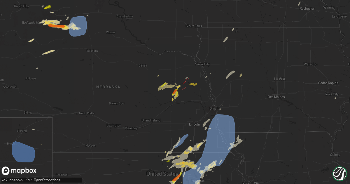
Hail Map on June 15, 2024
Get this storm
June 15 map
$229
one time, instant access
Download today. No call, no setup
Keep the $229
Bought the map and want the full workflow? Apply the entire $229 to a subscription within 7 days. None of it is wasted.
Every map, not just this one
This buys you this map. Subscription and you get every map we run, in the markets you choose from a few cities to whole states to nationwide. Plus real-time alerts the moment a storm fires.
Contact data
Name, contact info, occupancy, even credit band for addresses in the footprint. You go from where it hit to who to call.
Become the source they trust
Unlimited branding weather history reports on demand. You already have the documented answer ready for the property owner, and you are the one who showed up with it.
Property data and RoofTrace estimates
Pull up any address you have got, its value and the exact code rules for that jurisdiction, straight from One Click Code. Then RoofTrace estimates the squares, pitch, and roof value, priced the way you price.
States Impacted by Hail Map on June 15, 2024
Storm reports
Oklahoma
| Date | Description |
|---|---|
| 06/14/20248:30 PM CDT | Mostly dime hail with some quarters reported in knowles. Report was from the em... But was received second hand from the public. |
Montana
| Date | Description |
|---|---|
| 06/15/20246:58 PM CDT | Asos station kjdn jordan. |
| 06/15/20246:45 PM CDT | Mesonet station mting 1.6 w ingomar |
| 06/15/20245:18 PM CDT | Mesonet station fblm8 fort belknap raws. |
| 06/15/20245:05 PM CDT | Mesonet station fblm8 fort belknap raws. Time estimated. Lightning in the area at 405 pm. |
| 06/15/20244:45 PM CDT | Mesonet station mthay 6.1 sw hays |
| 06/15/20244:11 PM CDT | Asos station klvm livingston. |
| 06/15/20241:15 PM CDT | Mesonet station mtm76 cascade e mda. |
| 06/14/20249:58 PM CDT | Meso net observation |
| 06/14/20249:54 PM CDT | Mtdot savage mt-16. |
| 06/14/20249:30 PM CDT | Measured at the blm glendive mesonet site. |
| 06/14/20249:30 PM CDT | A local report indicates 60 MPH wind near 3 WSW Bainville |
| 06/14/20249:00 PM CDT | Estimated from acurite weather sensor. |
| 06/14/20249:00 PM CDT | Meso net observation reported a thunderstorm wind gust of 60 mph. |
| 06/14/20248:53 PM CDT | Asos station kmls miles city. |
| 06/14/20248:30 PM CDT | Lost power for 3 hours and blew trash cans off property. Report from facebook. |
| 06/14/20248:30 PM CDT | Meso net site recorded a thunderstorm wind gust of 61 mph. |
| 06/14/20248:25 PM CDT | Meso net observation reported a thunderstorm 61 mph gust. |
| 06/14/20248:25 PM CDT | Meso net observation reported a thunde |
| 06/14/20247:52 PM CDT | Measured at the fort peck dam mesonet site. |
| 06/14/20247:49 PM CDT | Mesonet station ew1247 forsyth. |
| 06/14/20247:44 PM CDT | Also received 0.13 of rain. Knocked old small branches down. |
| 06/14/20247:30 PM CDT | Meso net site recorded a thunderstorm wind gust of 67 mph. |
| 06/14/20247:09 PM CDT | Strong thunderstorm winds pushed a trailed pontoon into a ditch near fort peck. |
| 06/14/20247:09 PM CDT | A cocorahs and storm spotter reported a davis measured thunderstorm wind gust to 79 mph. |
| 06/14/20247:00 PM CDT | Asos kbil. |
South Dakota
| Date | Description |
|---|---|
| 06/15/20246:45 PM CDT | A local report indicates 59 MPH wind near Wasta |
| 06/15/20246:33 PM CDT | A local report indicates 60 MPH wind near 3 WSW Fairburn |
| 06/15/20246:25 PM CDT | A local report indicates 61 MPH wind near 7 W Ardmore |
| 06/14/202411:26 PM CDT | A local report indicates 67 MPH wind near 1 N Buffalo |
| 06/14/202410:59 PM CDT | Mesonet station rfps2 vivian 13 n. |
| 06/14/202410:25 PM CDT | Mesonet station 13 vivian |
| 06/14/20249:40 PM CDT | A local report indicates 60 MPH wind near 1 ESE Martin |
| 06/14/20249:35 PM CDT | A local report indicates 65 MPH wind near 4 WNW Cedar Butte |
| 06/14/20249:30 PM CDT | A local report indicates 62 MPH wind near 4 WNW Cedar Butte |
| 06/14/20249:28 PM CDT | A local report indicates 64 MPH wind near 6 W Parmelee |
| 06/14/20249:20 PM CDT | A local report indicates 1.00 inch wind near Lodgepole |
| 06/14/20249:00 PM CDT | A local report indicates 60 MPH wind near 5 SSE Belvidere |
| 06/14/20248:41 PM CDT | A local report indicates 65 MPH wind near 5 NE Porcupine |
| 06/14/20248:40 PM CDT | Hail estimated between 1.25 and 1.75 inches in diameter |
| 06/14/20248:15 PM CDT | A local report indicates 1.25 inch wind near 7 NE Ralph |
| 06/14/20247:16 PM CDT | Mostly small hail |
| 06/14/20247:15 PM CDT | A local report indicates 67 MPH wind near 4 NNE Angostura Res |
| 06/14/20247:07 PM CDT | Piles and drifts of small hail less than quarter size |
| 06/14/20247:06 PM CDT | Mping report |
Colorado
| Date | Description |
|---|---|
| 06/14/20249:03 PM CDT | A local report indicates 70 MPH wind near 14 NNE Arickaree School |
| 06/14/20248:56 PM CDT | Mesonet station ew7755 akron. |
| 06/14/20248:53 PM CDT | Awos station kako akron. |
Wyoming
| Date | Description |
|---|---|
| 06/14/20249:36 PM CDT | Asos station kshr sheridan. |
Kansas
| Date | Description |
|---|---|
| 06/15/20246:30 PM CDT | A local report indicates 60 MPH wind near 3 NW Vermillion |
| 06/15/20246:05 PM CDT | Personal weather station. |
| 06/15/20245:29 PM CDT | A local report indicates 66 MPH wind near 2 ENE Clay Center |
| 06/15/20245:25 PM CDT | A local report indicates 1.25 inch wind near Ness City |
| 06/15/20245:25 PM CDT | A local report indicates 70 MPH wind near 3 E Clay Center |
| 06/15/20245:21 PM CDT | A local report indicates 60 MPH wind near 4 NNW Woodbine |
| 06/15/20245:17 PM CDT | A local report indicates 60 MPH wind near 5 SSE Milford |
| 06/15/20244:52 PM CDT | A local report indicates 70 MPH wind near 4 SW Enterprise |
| 06/15/20244:51 PM CDT | Delayed report via social media of a healthy tree approximately one foot in diameter split in half. |
| 06/15/20244:50 PM CDT | Delayed report via social media of large tree limbs approximately 8 to 10 feet in diameter blown down. |
| 06/15/20244:49 PM CDT | Snapped tree relayed by kake tv. Time estimated from radar. |
| 06/15/20244:49 PM CDT | Delayed report of a large uprooted tree. Photo was sent via social media. Estimated wind speed of 75 mph. |
| 06/15/20244:47 PM CDT | Kk78. |
| 06/15/20244:36 PM CDT | Power poles broken and trees down between granite and homestead roads. Time estimated from radar. |
| 06/15/20244:15 PM CDT | Delayed report. Trees... Power lines and power poles down throughout salina. |
| 06/15/20244:10 PM CDT | Asos station khut hutchinson municipal airport. |
| 06/15/20244:09 PM CDT | Delayed report. Semi truck overturned on i-135 and mile post 91. This is on the southwest side of salina. |
| 06/15/20244:08 PM CDT | Asos station ksln salina regional airport. |
| 06/15/20244:05 PM CDT | Asos station ksln salina regional airport. |
| 06/15/20243:56 PM CDT | Delayed report. |
| 06/15/20243:48 PM CDT | A local report indicates 77 MPH wind near 3 E Hutchinson |
| 06/15/20243:45 PM CDT | Tree branches 10 inches in diameter are down. Power is also out. |
| 06/15/20243:18 PM CDT | Delayed report. Time estimated. Large tree branch down on house. |
| 06/15/20241:26 AM CDT | Sheriffs office reported minor tree damage in barnes. Time estimated from radar. |
| 06/15/202412:29 AM CDT | Personal weather station. |
| 06/14/202411:07 PM CDT | Tree damage north of oak hill. Medium sized branches down. |
| 06/14/202410:52 PM CDT | Estimated around quarter size. |
| 06/14/202410:45 PM CDT | Fm fb. |
| 06/14/202410:45 PM CDT | Fm fb. |
| 06/14/202410:25 PM CDT | From fb. |
| 06/14/202410:10 PM CDT | A local report indicates 1.00 inch wind near 3 SSW Bellefont |
| 06/14/20249:30 PM CDT | A local report indicates 1.00 inch wind near 3 ESE Spearville |
| 06/14/20248:39 PM CDT | From fb. |
| 06/14/20248:10 PM CDT | A local report indicates 2.50 inch wind near 9 WNW Spearville |
| 06/14/20248:08 PM CDT | Personal weather station. |
| 06/14/20247:40 PM CDT | Personal weather station. |
| 06/14/20247:35 PM CDT | Report received via social media at the boothill feeders. Photos and video taken. |
| 06/14/20247:30 PM CDT | A local report indicates 1.75 inch wind near 9 NW Englewood |
| 06/14/20247:12 PM CDT | A local report indicates 60 MPH wind near Corning |
| 06/14/20247:08 PM CDT | A local report indicates 64 MPH wind near 1 NNW Bern |
South Carolina
| Date | Description |
|---|---|
| 06/15/20244:59 PM CDT | Tree down near the intersection of ballpark rd and high heel rd |
| 06/15/20242:37 PM CDT | Sumter county sheriff dispatch reported a tree down on panda road at cane savannah road. |
Iowa
| Date | Description |
|---|---|
| 06/15/20241:45 AM CDT | Numerous trees down in town and the power is out. Possible structure damage in town also. |
| 06/15/20241:10 AM CDT | Out building damaged/destroyed. Damaged/caved in grain bin. |
| 06/15/20241:10 AM CDT | 10-12 inch tree limbs down. Power lines from electric pole to garage knocked down. Dime sized hail and 1.5 inches of rain. |
| 06/14/20249:35 PM CDT | Tree down on power line 1w spirit lake. |
| 06/14/20249:08 PM CDT | Multiple power poles and trees down in correctionville. Time estimated from radar. |
| 06/14/20248:33 PM CDT | Leaning power poles. Time estimated from radar. |
| 06/14/20248:18 PM CDT | Tree limbs blown down. |
Missouri
| Date | Description |
|---|---|
| 06/14/20248:32 PM CDT | Winds estimated to be near 60. |
| 06/14/20248:01 PM CDT | Several glass top tables sliding across yard. |
| 06/14/20247:52 PM CDT | A local report indicates 60 MPH wind near Rockport |
Texas
| Date | Description |
|---|---|
| 06/15/202412:43 AM CDT | A local report indicates 1.00 inch wind near 4 SE Courtney |
| 06/14/20249:44 PM CDT | Hail near or just above quarter size found after storm had passed. Time estimated from radar. |
| 06/14/20249:33 PM CDT | Wind gusts near 60 mph reported along highway 385 just northeast of seagraves. Time estimated from radar. |
| 06/14/20249:24 PM CDT | Motorists report golf ball size hail on highway 385 between wellman and seagraves. Time and location estimated from radar. |
| 06/14/20248:20 PM CDT | A local report indicates 62 MPH wind near 4 S Levelland |
Georgia
| Date | Description |
|---|---|
| 06/14/20247:29 PM CDT | Tree reported down on a fence on the 1900 block of lake ridge ct. |
Maine
| Date | Description |
|---|---|
| 06/15/20243:00 PM CDT | Delayed report. Quarter size hail reported by public via social media in lee. Time estimated by radar. |
North Dakota
| Date | Description |
|---|---|
| 06/15/20242:09 AM CDT | Late report. Large tree limbs down. North of the pumpkin patch. |
| 06/15/20241:32 AM CDT | Late report. Trees down and roof damage. |
| 06/15/202412:59 AM CDT | Late report. Damage to metigoshe drive in building. |
| 06/15/202412:46 AM CDT | 10 meter measured wind gust from ndawn station pick city 8sw. |
| 06/15/202412:43 AM CDT | Accompanied by strong winds and heavy rain. |
| 06/15/202412:37 AM CDT | Report from mping: 1-inch tree limbs broken; shingles blown off. |
| 06/15/202412:30 AM CDT | Photo of large tree branch down in street relayed through broadcast media. Time estimated from radar. |
| 06/15/202412:29 AM CDT | Measured wind gust from personal weather station. |
| 06/15/202412:22 AM CDT | Asos station kmot minot airport. |
| 06/15/202412:00 AM CDT | Accompanied by strong winds and heavy rain. Still raining. |
| 06/14/202411:57 PM CDT | Mesonet station lwdn8 lostwood. |
| 06/14/202411:43 PM CDT | 10 meter measured wind gust at ndawn station shell lake 2se. |
| 06/14/202411:35 PM CDT | Awos station kd60 tioga. |
| 06/14/202411:27 PM CDT | Measured wind gust from private weather station. |
| 06/14/202411:12 PM CDT | 10 meter measured wind gust at ndawn station ray |
| 06/14/202411:12 PM CDT | 10 meter measured wind gust at ndawn station ray 4n. |
| 06/14/202410:53 PM CDT | Measured wind gust at 3 meters at ndawn station hawkeye 3nw. |
| 06/14/202410:45 PM CDT | Measured wind gust relayed from public through social media. |
| 06/14/202410:40 PM CDT | Nddot us-85 arnegard station. |
| 06/14/202410:32 PM CDT | 10 meter measured wind gust from ndawn station ray 4n. |
| 06/14/202410:05 PM CDT | Measured wind gust from private weather station. |
| 06/14/202410:05 PM CDT | Measured 3 meter win |
| 06/14/202410:05 PM CDT | Measured 3 meter wind gust at ndawn station charbonneau 5nw. |
| 06/14/20249:24 PM CDT | Corrects previous hail report from 5 wnw heart butte dam. Facebook report and photos of brief large hail at campgrounds on north side of lake tschida. Time estimated ba |
| 06/14/20248:50 PM CDT | Hail lasted for 15 minutes. |
| 06/14/20248:30 PM CDT | Hail lasted from around 8:30 to 9:00 pm cdt. Largest hail was golf ball size. |
| 06/14/20248:28 PM CDT | Photo relayed through social media. |
| 06/14/20247:15 PM CDT | Hail lasted from 7:15 to 7:20 pm. |
Nebraska
| Date | Description |
|---|---|
| 06/15/20246:58 PM CDT | A local report indicates a tornado near 4 NE Pilger |
| 06/15/20246:56 PM CDT | Ef-0. Nws in collaboration with stanton county emergency management confirmed a tornado damage path that began at this location. Documented from storm chaser video... T |
| 06/15/20246:55 PM CDT | Report from mping: 1-inch tree limbs broken; shingles blown off. |
| 06/15/20246:45 PM CDT | Approximately a 5 mile long by 2 mile wide swath of hail with up to golfball size observed. |
| 06/15/20246:37 PM CDT | Ef-0. Nws in collaboration with stanton county emergency management confirmed that a tornado occurred at this location. This was a very brief tornado caused window dama |
| 06/15/20246:14 PM CDT | Photo evidence and eyewitness reports of a funnel cloud with a short-lived ground circulation and dust cloud. Brief tornado at this location. |
| 06/15/20245:50 PM CDT | A local report indicates a tornado near 4 SSW Battle Creek |
| 06/15/20245:28 PM CDT | A local report indicates a tornado near 10 S Tilden |
| 06/15/20244:47 PM CDT | Mesonet recorded a gust of 58 mph. |
| 06/14/20248:28 PM CDT | Report from mping: 1-inch tree limbs broken; shingles blown off. |
| 06/14/20248:15 PM CDT | At the airport. |
| 06/14/20247:56 PM CDT | Public weather station measured gust. |
| 06/14/20247:45 PM CDT | Report from mping: 1-inch tree limbs broken; shingles blown off. |
| 06/14/20247:31 PM CDT | A local report indicates 69 MPH wind near 3 SW Nemaha |
| 06/14/20247:28 PM CDT | A local report indicates a tornado near 8 N Howells |
| 06/14/20247:21 PM CDT | A local report indicates a tornado near 3 W Pender |
| 06/14/20247:16 PM CDT | A local report indicates a tornado near 7 NNE Clarkson |
| 06/14/20247:13 PM CDT | A local report indicates 60 MPH wind near 3 W Plattsmouth |
| 06/14/20247:10 PM CDT | A local report indicates a tornado near 5 N Clarkson |
| 06/14/20247:09 PM CDT | Personal weather station measured gust. |
| 06/14/20247:07 PM CDT | A local report indicates a tornado near 4 N Clarkson |
| 06/14/20247:07 PM CDT | Photo of brief tornado at this location. Watched the tornado travel for approximately a half mile. No damage. |
| 06/14/20247:07 PM CDT | A local report indicates 60 MPH wind near 3 E Johnson |
| 06/14/20247:06 PM CDT | Ef-1. Nws in coordination with stanton county emergency management concluded that an ef-1 tornado began at this location. Based on chaser video as well as drone footage |
Cities Impacted by Hail Map on June 15, 2024
- Birmingham, IA
- Fairfield, IA
- Stockport, IA
- Hillsboro, IA
- Donnellson, IA
- Salem, IA
- West Point, IA
- Highwood, MT
- Fort Benton, MT
- Nickerson, KS
- Abbyville, KS
- Conway, SC
- Partridge, KS
- Loris, SC
- Longs, SC
- Winter Garden, FL
- Clermont, FL
- Lyons, KS
- Little River, KS
- Republic, KS
- Sterling, KS
- Hutchinson, KS
- Byron, NE
- South Hutchinson, KS
- Ocala, FL
- Windermere, FL
- Oakland, FL
- Wildwood, FL
- The Villages, FL
- Hilger, MT
- Lloyd, MT
- Deshler, NE
- Fruitland Park, FL
- Leesburg, FL
- Lewistown, MT
- Denton, MT
- Yalaha, FL
- Lindsborg, KS
- Salina, KS
- Winifred, MT
- Hebron, NE
- Belleville, KS
- Buhler, KS
- Burrton, KS
- New Cambria, KS
- Belvidere, NE
- Clearwater, NE
- Chester, NE
- Hay Springs, NE
- Ingalls, KS
- Solomon, KS
- Stanton, ND
- Hazen, ND
- Lake City, SC
- Neligh, NE
- Hubbell, NE
- Munden, KS
- Petersburg, NE
- Albion, NE
- Dunnellon, FL
- Cimarron, KS
- Hope, KS
- Abilene, KS
- Gypsum, KS
- Enterprise, KS
- Gilead, NE
- Fairbury, NE
- Alexandria, NE
- Daykin, NE
- Amidon, ND
- New England, ND
- Scranton, SC
- Zortman, MT
- Swanton, NE
- Western, NE
- Plymouth, NE
- Wilber, NE
- Herington, KS
- Chapman, KS
- Woodbine, KS
- Morrowville, KS
- Washington, KS
- Plainview, NE
- Brunswick, NE
- Ryegate, MT
- Lavina, MT
- Tilden, NE
- Micanopy, FL
- De Witt, NE
- Wakefield, KS
- Clay Center, KS
- Junction City, KS
- Minneapolis, KS
- Newman Grove, NE
- Longford, KS
- Tobias, NE
- Belfield, ND
- Ness City, KS
- Meadow Grove, NE
- Green, KS
- Roundup, MT
- Hollenberg, KS
- White City, KS
- Platte Center, NE
- Creston, NE
- Columbus, NE
- South Heart, ND
- Greenleaf, KS
- Bazine, KS
- Odell, NE
- Diller, NE
- Ransom, KS
- Brownell, KS
- Fort Riley, KS
- Riley, KS
- Milford, KS
- Dwight, KS
- Manhattan, KS
- Olsburg, KS
- Ogden, KS
- Leonardville, KS
- Randolph, KS
- Westmoreland, KS
- Humphrey, NE
- Meade, KS
- Gate, OK
- Monroe, NE
- Norfolk, NE
- Madison, NE
- Wymore, NE
- Blue Springs, NE
- Steele City, NE
- Leigh, NE
- Saint George, KS
- Englewood, KS
- Jetmore, KS
- Dodge City, KS
- Battle Creek, NE
- Churchs Ferry, ND
- Cando, ND
- Pierce, NE
- Beatrice, NE
- Endicott, NE
- Hoskins, NE
- McCracken, KS
- Canadian, TX
- Osmond, NE
- Andrews, SC
- Stanton, NE
- Onaga, KS
- Starkweather, ND
- Forgan, OK
- Fort Peck, MT
- Lindsay, NE
- Wisner, NE
- Pilger, NE
- Wall, SD
- Unadilla, NE
- Palmyra, NE
- Weeping Water, NE
- Eagle, NE
- Murdock, NE
- Elmwood, NE
- Sturgis, SD
- Minneola, KS
- Burns, WY
- Cheyenne, WY
- Virginia, NE
- Miami, TX
- Hanover, KS
- Clarkson, NE
- Quinn, SD
- Buffalo, SD
- Corning, KS
- Havensville, KS
- Goff, KS
- Humboldt, NE
- Seneca, KS
- Du Bois, NE
- Frankfort, KS
- Oneida, KS
- Bern, KS
- Centralia, KS
- Baileyville, KS
- Table Rock, NE
- Pawnee City, NE
- Axtell, KS
- Vermillion, KS
- Marysville, KS
- Waterville, KS
- Blue Rapids, KS
- Beattie, KS
- Home, KS
- Summerfield, KS
- Burchard, NE
- Mullinville, KS
- Wayne, NE
- Pine Bluffs, WY
- New Underwood, SD
- Lewiston, NE
- Manley, NE
- Louisville, NE
- Howells, NE
- Durham, OK
- Quanah, TX
- Sweetwater, OK
- Reydon, OK
- Crowell, TX
- Seymour, TX
- Abilene, TX
- Rosston, OK
- Haskell, TX
- Laverne, OK
- Gould, OK
- Munday, TX
- Lueders, TX
- Weinert, TX
- Cheyenne, OK
- Erick, OK
- Mangum, OK
- Clyde, TX
- Eldorado, OK
- Shattuck, OK
- Stamford, TX
- Vinson, OK
- Coleman, TX
- Arnett, OK
- Sayre, OK
- Nashua, MT
- Coyanosa, TX
- Glasgow, MT
- Kingstree, SC
- Walton, NE
- Lincoln, NE
- Haven, KS
- Pretty Prairie, KS
- Marathon, TX
- Wetmore, KS
- Sabetha, KS
- Dawson, NE
- Morrill, KS
- Fairview, KS
- Salem, NE
- Verdon, NE
- Peru, NE
- Stella, NE
- Nemaha, NE
- Auburn, NE
- Shubert, NE
- Brownville, NE
- Wright, KS
- Hampden, ND
- Beemer, NE
- Fowler, KS
- Haviland, KS
- Kyle, SD
- Alsen, ND
- Netawaka, KS
- Powhattan, KS
- Rock Port, MO
- Falls City, NE
- Fairfax, MO
- Hiawatha, KS
- Craig, MO
- Watson, MO
- Regent, ND
- Lefor, ND
- Plattsmouth, NE
- Thurman, IA
- Hamburg, IA
- Sidney, IA
- Nebraska City, NE
- Percival, IA
- Pacific Junction, IA
- Nehawka, NE
- Syracuse, NE
- Dunbar, NE
- Union, NE
- Elk Creek, NE
- Cook, NE
- Brock, NE
- Tecumseh, NE
- Avoca, NE
- Murray, NE
- Johnson, NE
- Otoe, NE
- Julian, NE
- Sterling, NE
- Talmage, NE
- Steinauer, NE
- Lorton, NE
- Frazer, MT
- Enning, SD
- Pine Ridge, SD
- Gordon, NE
- Crab Orchard, NE
- Wanblee, SD
- Oglala, SD
- Wolf Point, MT
- Mott, ND
- Shenandoah, IA
- Northboro, IA
- Essex, IA
- Tarkio, MO
- Farragut, IA
- Red Oak, IA
- Coin, IA
- Riverton, IA
- Westboro, MO
- Imogene, IA
- Malvern, IA
- Randolph, IA
- Emerson, IA
- Glenwood, IA
- Tabor, IA
- Hastings, IA
- Bellevue, NE
- Council Bluffs, IA
- Silver City, IA
- Elmo, MO
- Blanchard, IA
- Rulo, NE
- Horton, KS
- Mound City, MO
- Whiting, KS
- Spearville, KS
- Langdon, ND
- Hanston, KS
- West Point, NE
- Bancroft, NE
- Plains, TX
- Levelland, TX
- Ralph, SD
- Circle, MT
- Hartley, IA
- Primghar, IA
- Liberty, NE
- Filley, NE
- Lodgepole, SD
- Skidmore, MO
- White Cloud, KS
- Maitland, MO
- Burlington Junction, MO
- Clarinda, IA
- Dickinson, ND
- Osnabrock, ND
- Macy, NE
- Decatur, NE
- Minden, IA
- McClelland, IA
- Underwood, IA
- Burdett, KS
- Poplar, MT
- Jordan, MT
- Cohagen, MT
- Vida, MT
- Brockway, MT
- Bloomfield, MT
- Richey, MT
- Lambert, MT
- Brockton, MT
- Richardton, ND
- Brownfield, TX
- Rozel, KS
- Sloan, IA
- Whiting, IA
- Walhalla, ND
- Lyons, NE
- Glendive, MT
- Savage, MT
- Fairview, MT
- Culbertson, MT
- Froid, MT
- Fort Stockton, TX
- Denver City, TX
- Hornick, IA
- Long Valley, SD
- Hebron, ND
- New Leipzig, ND
- Alexander, KS
- Lindsay, MT
- Carpenter, WY
- Lathrop, MO
- Ropesville, TX
- Meadow, TX
- Larned, KS
- Lemmon, SD
- Glen Ullin, ND
- Sidney, MT
- Crane, MT
- Bainville, MT
- Scandia, KS
- Courtland, KS
- Sanborn, IA
- Whiteface, TX
- Soldier, KS
- Loop, TX
- Lake Park, IA
- Sundown, TX
- Maryville, MO
- Spirit Lake, IA
- Graham, MO
- Seagraves, TX
- White River, SD
- Parmelee, SD
- Saint Francis, SD
- Norris, SD
- Okaton, SD
- Martin, SD
- Murdo, SD
- Cartwright, ND
- Grassy Butte, ND
- Williston, ND
- Alexander, ND
- Trenton, ND
- Woodrow, CO
- Otis, CO
- Yuma, CO
- Cope, CO
- Lindon, CO
- Anton, CO
- Akron, CO
- Brush, CO
- Offerle, KS
- Kinsley, KS
- Almont, ND
- Keldron, SD
- Kit Carson, CO
- Seminole, TX
- Watford City, ND
- Ray, ND
- Tioga, ND
- Arnegard, ND
- Epping, ND
- Wildrose, ND
- Alamo, ND
- Bennington, KS
- Ludlow, SD
- Scenic, SD
- Rushville, NE
- Morristown, SD
- Miltonvale, KS
- Mantorville, MN
- West Concord, MN
- Mcgregor, ND
- Reva, SD
- Merriman, NE
- White Earth, ND
- Crosby, ND
- Clyde, KS
- Concordia, KS
- Dagmar, MT
- Stanley, ND
- Powers Lake, ND
- Ross, ND
- Wasta, SD
- Pine Island, MN
- Bucklin, KS
- Keene, ND
- Noonan, ND
- Columbus, ND
- Ambrose, ND
- Lamesa, TX
- Tarzan, TX
- Zahl, ND
- Grenora, ND
- Lignite, ND
- Portal, ND
- Prairie City, SD
- Hettinger, ND
- Kenmare, ND
- Palermo, ND
- Mandaree, ND
- New Town, ND
- Killdeer, ND
- Morganville, KS
- Clifton, KS
- Bowbells, ND
- Agenda, KS
- Clearmont, MO
- Donnybrook, ND
- Palmer, KS
- Linn, KS
- Tolley, ND
- Manning, ND
- Berthold, ND
- Stanton, TX
- Plaza, ND
- Parshall, ND
- Roseglen, ND
- Lenorah, TX
- Taylor, ND
- Gladstone, ND
- Maxbass, ND
- Mohall, ND
- Fleming, CO
- Carpio, ND
- Burlington, ND
- Des Lacs, ND
- Makoti, ND
- Ryder, ND
- Minot, ND
- Minot Afb, ND
- Lansford, ND
- Glenburn, ND
- Surrey, ND
- Norwich, ND
- Deering, ND
- Newburg, ND
- Upham, ND
- Westhope, ND
- Owanka, SD
- Dodge, ND
- Halliday, ND
- Haddam, KS
- Manilla, IA
- Roswell, NM
- Kadoka, SD
- Eckley, CO
- Midland, SD
- Milesville, SD
- Interior, SD
- Golden Valley, ND
- Zap, ND
- Dunn Center, ND
- Beulah, ND
- Granville, ND
- Bantry, ND
- Souris, ND
- Kramer, ND
- Haxtun, CO
- Delphos, KS
- Philip, SD
- Schleswig, IA
- Riverdale, ND
- Underwood, ND
- Coleharbor, ND
- Ida Grove, IA
- Kiron, IA
- Denison, IA
- Norway, KS
- Jamestown, KS
- Bagley, IA
- Barnes, KS
- Elgin, ND
- Odebolt, IA
- Arcadia, IA
- Carroll, IA
- Breda, IA
- Cuba, KS
- Westside, IA
- Elida, NM
- Auburn, IA
- Birmingham, AL
- Fairfield, AL
- Lake City, IA
- Watauga, SD
- Tokio, TX
- Narka, KS
- Mahaska, KS
- Lake View, IA
- Alta Vista, KS
- Charter Oak, IA
- Jefferson, IA
- Alma, KS
- Arthur, IA
- Wall Lake, IA
- Strasburg, ND
- Sac City, IA
- Rockwell City, IA
- Lytton, IA
- Scott City, KS
- New Salem, ND
- Carson, ND
- Fairdale, ND
- Jamestown, ND
- Sanborn, ND
- Spiritwood, ND
- Arapaho, OK
- Tampa, KS
- Ramona, KS
- Lone Tree, IA
- Lost Springs, KS
- Durham, KS
- Rocky, OK
- Valley City, ND
- Dazey, ND
- Wimbledon, ND
- Sarles, ND
- Hannaford, ND
- Cooperstown, ND
- Wamego, KS
- Marion, KS
- Talmage, KS
- Sentinel, OK
- Dill City, OK
- Cordell, OK
- Custer City, OK
- Taloga, OK
- Corn, OK
- Clinton, OK
- Courtenay, ND
- Winona, KS
- Hobart, OK
- Gotebo, OK
- Ayr, ND
- Buffalo, ND
- Tower City, ND
- Wheatland, ND
- Casselton, ND
- Amenia, ND
- Galva, KS
- Finley, ND
- Luverne, ND
- Putnam, OK
- Canton, KS
- Harwood, ND
- Lehigh, KS
- Hillsboro, KS
- Mchenry, ND
- Sherwood, ND
- Rugby, ND
- Edmore, ND
- Butler, OK
- Foss, OK