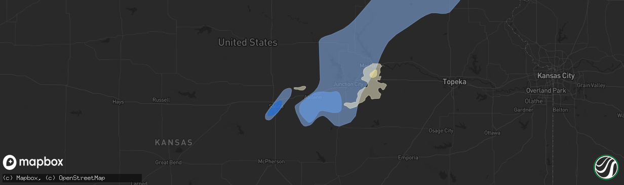
Hail Map in Abilene, KS on June 15, 2024
The weather event in Abilene, KS on June 15, 2024 includes Wind, Hail, and Tornado maps. 16 states and 625 cities were impacted and suffered possible damage. The total estimated number of properties impacted is 0.
Wind
Hail
Tornado
0
Estimated number of impacted properties by a 1.00" hail or larger0
Estimated number of impacted properties by a 1.75" hail or larger0
Estimated number of impacted properties by a 2.50" hail or largerStorm reports in Abilene, KS
Abilene, KS
| Date | Description |
|---|---|
| 06/15/20244:52 PM CDT | A local report indicates 70 MPH wind near 4 SW Enterprise |
| 06/15/20244:50 PM CDT | Delayed report via social media of large tree limbs approximately 8 to 10 feet in diameter blown down. |
| 06/15/20244:49 PM CDT | Snapped tree relayed by kake tv. Time estimated from radar. |
| 06/15/20244:49 PM CDT | Delayed report of a large uprooted tree. Photo was sent via social media. Estimated wind speed of 75 mph. |
| 06/15/20244:47 PM CDT | Kk78. |
All States Impacted by Hail Map on June 15, 2024
All Cities Impacted by Hail Map on June 15, 2024
- Birmingham, IA
- Fairfield, IA
- Stockport, IA
- Hillsboro, IA
- Donnellson, IA
- Salem, IA
- West Point, IA
- Highwood, MT
- Fort Benton, MT
- Nickerson, KS
- Abbyville, KS
- Conway, SC
- Partridge, KS
- Loris, SC
- Longs, SC
- Winter Garden, FL
- Clermont, FL
- Lyons, KS
- Little River, KS
- Republic, KS
- Sterling, KS
- Hutchinson, KS
- Byron, NE
- South Hutchinson, KS
- Ocala, FL
- Windermere, FL
- Oakland, FL
- Wildwood, FL
- The Villages, FL
- Hilger, MT
- Lloyd, MT
- Deshler, NE
- Fruitland Park, FL
- Leesburg, FL
- Lewistown, MT
- Denton, MT
- Yalaha, FL
- Lindsborg, KS
- Salina, KS
- Winifred, MT
- Hebron, NE
- Belleville, KS
- Buhler, KS
- Burrton, KS
- New Cambria, KS
- Belvidere, NE
- Clearwater, NE
- Chester, NE
- Hay Springs, NE
- Ingalls, KS
- Solomon, KS
- Stanton, ND
- Hazen, ND
- Lake City, SC
- Neligh, NE
- Hubbell, NE
- Munden, KS
- Petersburg, NE
- Albion, NE
- Dunnellon, FL
- Cimarron, KS
- Hope, KS
- Abilene, KS
- Gypsum, KS
- Enterprise, KS
- Gilead, NE
- Fairbury, NE
- Alexandria, NE
- Daykin, NE
- Amidon, ND
- New England, ND
- Scranton, SC
- Zortman, MT
- Swanton, NE
- Western, NE
- Plymouth, NE
- Wilber, NE
- Herington, KS
- Chapman, KS
- Woodbine, KS
- Morrowville, KS
- Washington, KS
- Plainview, NE
- Brunswick, NE
- Ryegate, MT
- Lavina, MT
- Tilden, NE
- Micanopy, FL
- De Witt, NE
- Wakefield, KS
- Clay Center, KS
- Junction City, KS
- Minneapolis, KS
- Newman Grove, NE
- Longford, KS
- Tobias, NE
- Belfield, ND
- Ness City, KS
- Meadow Grove, NE
- Green, KS
- Roundup, MT
- Hollenberg, KS
- White City, KS
- Platte Center, NE
- Creston, NE
- Columbus, NE
- South Heart, ND
- Greenleaf, KS
- Bazine, KS
- Odell, NE
- Diller, NE
- Ransom, KS
- Brownell, KS
- Fort Riley, KS
- Riley, KS
- Milford, KS
- Dwight, KS
- Manhattan, KS
- Olsburg, KS
- Ogden, KS
- Leonardville, KS
- Randolph, KS
- Westmoreland, KS
- Humphrey, NE
- Meade, KS
- Gate, OK
- Monroe, NE
- Norfolk, NE
- Madison, NE
- Wymore, NE
- Blue Springs, NE
- Steele City, NE
- Leigh, NE
- Saint George, KS
- Englewood, KS
- Jetmore, KS
- Dodge City, KS
- Battle Creek, NE
- Churchs Ferry, ND
- Cando, ND
- Pierce, NE
- Beatrice, NE
- Endicott, NE
- Hoskins, NE
- McCracken, KS
- Canadian, TX
- Osmond, NE
- Andrews, SC
- Stanton, NE
- Onaga, KS
- Starkweather, ND
- Forgan, OK
- Fort Peck, MT
- Lindsay, NE
- Wisner, NE
- Pilger, NE
- Wall, SD
- Unadilla, NE
- Palmyra, NE
- Weeping Water, NE
- Eagle, NE
- Murdock, NE
- Elmwood, NE
- Sturgis, SD
- Minneola, KS
- Burns, WY
- Cheyenne, WY
- Virginia, NE
- Miami, TX
- Hanover, KS
- Clarkson, NE
- Quinn, SD
- Buffalo, SD
- Corning, KS
- Havensville, KS
- Goff, KS
- Humboldt, NE
- Seneca, KS
- Du Bois, NE
- Frankfort, KS
- Oneida, KS
- Bern, KS
- Centralia, KS
- Baileyville, KS
- Table Rock, NE
- Pawnee City, NE
- Axtell, KS
- Vermillion, KS
- Marysville, KS
- Waterville, KS
- Blue Rapids, KS
- Beattie, KS
- Home, KS
- Summerfield, KS
- Burchard, NE
- Mullinville, KS
- Wayne, NE
- Pine Bluffs, WY
- New Underwood, SD
- Lewiston, NE
- Manley, NE
- Louisville, NE
- Howells, NE
- Durham, OK
- Quanah, TX
- Sweetwater, OK
- Reydon, OK
- Crowell, TX
- Seymour, TX
- Abilene, TX
- Rosston, OK
- Haskell, TX
- Laverne, OK
- Gould, OK
- Munday, TX
- Lueders, TX
- Weinert, TX
- Cheyenne, OK
- Erick, OK
- Mangum, OK
- Clyde, TX
- Eldorado, OK
- Shattuck, OK
- Stamford, TX
- Vinson, OK
- Coleman, TX
- Arnett, OK
- Sayre, OK
- Nashua, MT
- Coyanosa, TX
- Glasgow, MT
- Kingstree, SC
- Walton, NE
- Lincoln, NE
- Haven, KS
- Pretty Prairie, KS
- Marathon, TX
- Wetmore, KS
- Sabetha, KS
- Dawson, NE
- Morrill, KS
- Fairview, KS
- Salem, NE
- Verdon, NE
- Peru, NE
- Stella, NE
- Nemaha, NE
- Auburn, NE
- Shubert, NE
- Brownville, NE
- Wright, KS
- Hampden, ND
- Beemer, NE
- Fowler, KS
- Haviland, KS
- Kyle, SD
- Alsen, ND
- Netawaka, KS
- Powhattan, KS
- Rock Port, MO
- Falls City, NE
- Fairfax, MO
- Hiawatha, KS
- Craig, MO
- Watson, MO
- Regent, ND
- Lefor, ND
- Plattsmouth, NE
- Thurman, IA
- Hamburg, IA
- Sidney, IA
- Nebraska City, NE
- Percival, IA
- Pacific Junction, IA
- Nehawka, NE
- Syracuse, NE
- Dunbar, NE
- Union, NE
- Elk Creek, NE
- Cook, NE
- Brock, NE
- Tecumseh, NE
- Avoca, NE
- Murray, NE
- Johnson, NE
- Otoe, NE
- Julian, NE
- Sterling, NE
- Talmage, NE
- Steinauer, NE
- Lorton, NE
- Frazer, MT
- Enning, SD
- Pine Ridge, SD
- Gordon, NE
- Crab Orchard, NE
- Wanblee, SD
- Oglala, SD
- Wolf Point, MT
- Mott, ND
- Shenandoah, IA
- Northboro, IA
- Essex, IA
- Tarkio, MO
- Farragut, IA
- Red Oak, IA
- Coin, IA
- Riverton, IA
- Westboro, MO
- Imogene, IA
- Malvern, IA
- Randolph, IA
- Emerson, IA
- Glenwood, IA
- Tabor, IA
- Hastings, IA
- Bellevue, NE
- Council Bluffs, IA
- Silver City, IA
- Elmo, MO
- Blanchard, IA
- Rulo, NE
- Horton, KS
- Mound City, MO
- Whiting, KS
- Spearville, KS
- Langdon, ND
- Hanston, KS
- West Point, NE
- Bancroft, NE
- Plains, TX
- Levelland, TX
- Ralph, SD
- Circle, MT
- Hartley, IA
- Primghar, IA
- Liberty, NE
- Filley, NE
- Lodgepole, SD
- Skidmore, MO
- White Cloud, KS
- Maitland, MO
- Burlington Junction, MO
- Clarinda, IA
- Dickinson, ND
- Osnabrock, ND
- Macy, NE
- Decatur, NE
- Minden, IA
- McClelland, IA
- Underwood, IA
- Burdett, KS
- Poplar, MT
- Jordan, MT
- Cohagen, MT
- Vida, MT
- Brockway, MT
- Bloomfield, MT
- Richey, MT
- Lambert, MT
- Brockton, MT
- Richardton, ND
- Brownfield, TX
- Rozel, KS
- Sloan, IA
- Whiting, IA
- Walhalla, ND
- Lyons, NE
- Glendive, MT
- Savage, MT
- Fairview, MT
- Culbertson, MT
- Froid, MT
- Fort Stockton, TX
- Denver City, TX
- Hornick, IA
- Long Valley, SD
- Hebron, ND
- New Leipzig, ND
- Alexander, KS
- Lindsay, MT
- Carpenter, WY
- Lathrop, MO
- Ropesville, TX
- Meadow, TX
- Larned, KS
- Lemmon, SD
- Glen Ullin, ND
- Sidney, MT
- Crane, MT
- Bainville, MT
- Scandia, KS
- Courtland, KS
- Sanborn, IA
- Whiteface, TX
- Soldier, KS
- Loop, TX
- Lake Park, IA
- Sundown, TX
- Maryville, MO
- Spirit Lake, IA
- Graham, MO
- Seagraves, TX
- White River, SD
- Parmelee, SD
- Saint Francis, SD
- Norris, SD
- Okaton, SD
- Martin, SD
- Murdo, SD
- Cartwright, ND
- Grassy Butte, ND
- Williston, ND
- Alexander, ND
- Trenton, ND
- Woodrow, CO
- Otis, CO
- Yuma, CO
- Cope, CO
- Lindon, CO
- Anton, CO
- Akron, CO
- Brush, CO
- Offerle, KS
- Kinsley, KS
- Almont, ND
- Keldron, SD
- Kit Carson, CO
- Seminole, TX
- Watford City, ND
- Ray, ND
- Tioga, ND
- Arnegard, ND
- Epping, ND
- Wildrose, ND
- Alamo, ND
- Bennington, KS
- Ludlow, SD
- Scenic, SD
- Rushville, NE
- Morristown, SD
- Miltonvale, KS
- Mantorville, MN
- West Concord, MN
- Mcgregor, ND
- Reva, SD
- Merriman, NE
- White Earth, ND
- Crosby, ND
- Clyde, KS
- Concordia, KS
- Dagmar, MT
- Stanley, ND
- Powers Lake, ND
- Ross, ND
- Wasta, SD
- Pine Island, MN
- Bucklin, KS
- Keene, ND
- Noonan, ND
- Columbus, ND
- Ambrose, ND
- Lamesa, TX
- Tarzan, TX
- Zahl, ND
- Grenora, ND
- Lignite, ND
- Portal, ND
- Prairie City, SD
- Hettinger, ND
- Kenmare, ND
- Palermo, ND
- Mandaree, ND
- New Town, ND
- Killdeer, ND
- Morganville, KS
- Clifton, KS
- Bowbells, ND
- Agenda, KS
- Clearmont, MO
- Donnybrook, ND
- Palmer, KS
- Linn, KS
- Tolley, ND
- Manning, ND
- Berthold, ND
- Stanton, TX
- Plaza, ND
- Parshall, ND
- Roseglen, ND
- Lenorah, TX
- Taylor, ND
- Gladstone, ND
- Maxbass, ND
- Mohall, ND
- Fleming, CO
- Carpio, ND
- Burlington, ND
- Des Lacs, ND
- Makoti, ND
- Ryder, ND
- Minot, ND
- Minot Afb, ND
- Lansford, ND
- Glenburn, ND
- Surrey, ND
- Norwich, ND
- Deering, ND
- Newburg, ND
- Upham, ND
- Westhope, ND
- Owanka, SD
- Dodge, ND
- Halliday, ND
- Haddam, KS
- Manilla, IA
- Roswell, NM
- Kadoka, SD
- Eckley, CO
- Midland, SD
- Milesville, SD
- Interior, SD
- Golden Valley, ND
- Zap, ND
- Dunn Center, ND
- Beulah, ND
- Granville, ND
- Bantry, ND
- Souris, ND
- Kramer, ND
- Haxtun, CO
- Delphos, KS
- Philip, SD
- Schleswig, IA
- Riverdale, ND
- Underwood, ND
- Coleharbor, ND
- Ida Grove, IA
- Kiron, IA
- Denison, IA
- Norway, KS
- Jamestown, KS
- Bagley, IA
- Barnes, KS
- Elgin, ND
- Odebolt, IA
- Arcadia, IA
- Carroll, IA
- Breda, IA
- Cuba, KS
- Westside, IA
- Elida, NM
- Auburn, IA
- Birmingham, AL
- Fairfield, AL
- Lake City, IA
- Watauga, SD
- Tokio, TX
- Narka, KS
- Mahaska, KS
- Lake View, IA
- Alta Vista, KS
- Charter Oak, IA
- Jefferson, IA
- Alma, KS
- Arthur, IA
- Wall Lake, IA
- Strasburg, ND
- Sac City, IA
- Rockwell City, IA
- Lytton, IA
- Scott City, KS
- New Salem, ND
- Carson, ND
- Fairdale, ND
- Jamestown, ND
- Sanborn, ND
- Spiritwood, ND
- Arapaho, OK
- Tampa, KS
- Ramona, KS
- Lone Tree, IA
- Lost Springs, KS
- Durham, KS
- Rocky, OK
- Valley City, ND
- Dazey, ND
- Wimbledon, ND
- Sarles, ND
- Hannaford, ND
- Cooperstown, ND
- Wamego, KS
- Marion, KS
- Talmage, KS
- Sentinel, OK
- Dill City, OK
- Cordell, OK
- Custer City, OK
- Taloga, OK
- Corn, OK
- Clinton, OK
- Courtenay, ND
- Winona, KS
- Hobart, OK
- Gotebo, OK
- Ayr, ND
- Buffalo, ND
- Tower City, ND
- Wheatland, ND
- Casselton, ND
- Amenia, ND
- Galva, KS
- Finley, ND
- Luverne, ND
- Putnam, OK
- Canton, KS
- Harwood, ND
- Lehigh, KS
- Hillsboro, KS
- Mchenry, ND
- Sherwood, ND
- Rugby, ND
- Edmore, ND
- Butler, OK
- Foss, OK


