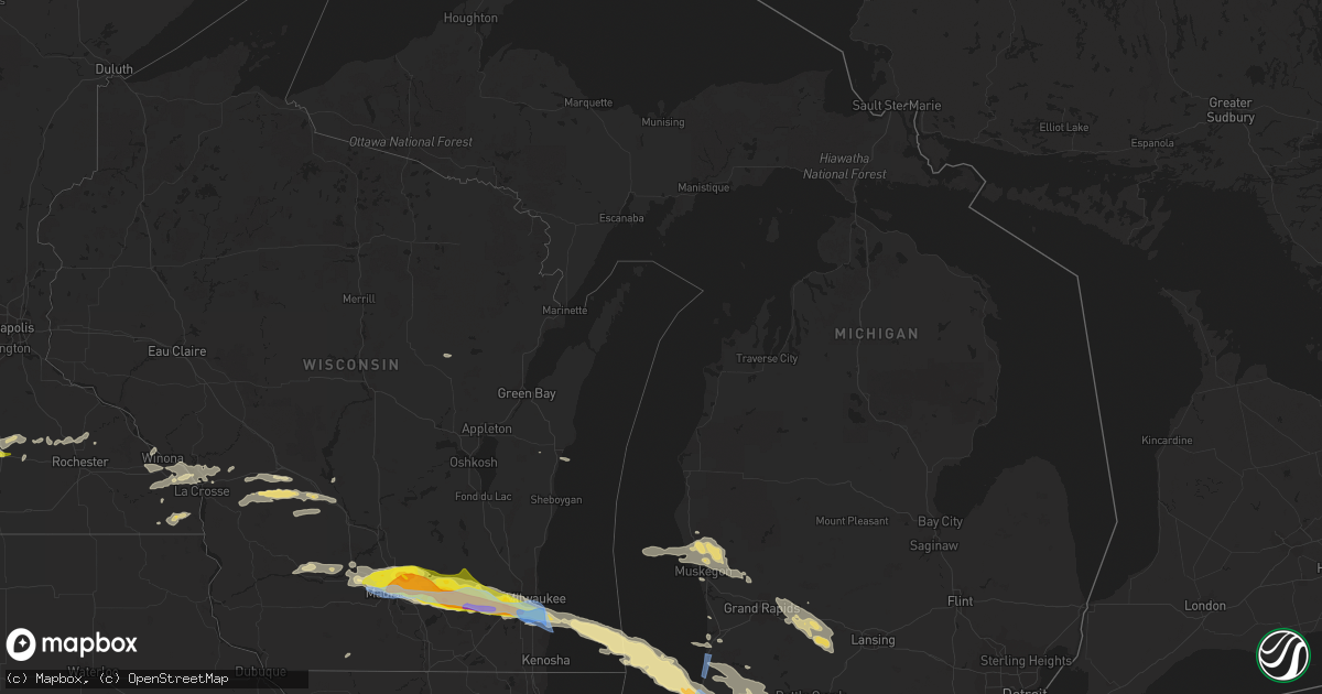
Hail Map in Michigan on June 13, 2022
Get this storm
June 13 map
$229
one time, instant access
Download today. No call, no setup
Keep the $229
Bought the map and want the full workflow? Apply the entire $229 to a subscription within 7 days. None of it is wasted.
Every map, not just this one
This buys you this map. Subscription and you get every map we run, in the markets you choose from a few cities to whole states to nationwide. Plus real-time alerts the moment a storm fires.
Contact data
Name, contact info, occupancy, even credit band for addresses in the footprint. You go from where it hit to who to call.
Become the source they trust
Unlimited branding weather history reports on demand. You already have the documented answer ready for the property owner, and you are the one who showed up with it.
Property data and RoofTrace estimates
Pull up any address you have got, its value and the exact code rules for that jurisdiction, straight from One Click Code. Then RoofTrace estimates the squares, pitch, and roof value, priced the way you price.
Storm reports in Michigan
Michigan
| Date | Description |
|---|---|
| 06/13/20226:55 PM CDT | Small tree limb damage. Report of a car on its side. Through spotternetwork.org. Time estimated by radar. |
| 06/13/20226:53 PM CDT | Multiple trees down... Including one on a car. Reports of flooding around the city. |
| 06/13/20226:40 PM CDT | A local report indicates 1.00 inch wind near 2 SSW PINE GROVE |
| 06/13/20226:40 PM CDT | A local report indicates 1.00 inch wind near 3 ENE HARTFORD |
| 06/13/20226:40 PM CDT | Delayed report. Quarter-sized hail near lawrence via social media. Numerous tree branches also down. |
| 06/13/20226:35 PM CDT | Report from mping: trees uprooted or snapped. |
| 06/13/20226:25 PM CDT | Large tree down on lines. |
| 06/13/20226:25 PM CDT | Large tree down on house. |
| 06/13/20226:22 PM CDT | Large tree down on power lines. |
| 06/13/20226:20 PM CDT | Vehicle accident into power pole |
| 06/13/20224:38 AM CDT | At 938 PM EDT, severe thunderstorms were located along a line extending from near Blissfield to near Swanton to near Napoleon, moving southeast at 45 mph. HAZARD...60 mph wind gusts and penny size hail. SOURCE...Radar indicated. IMPACT...Expect damage to trees and power lines. Locations impacted include... Toledo, Bowling Green, Perrysburg, Oregon, Sylvania, Rossford, Waterville, Northwood, Whitehouse, Gibsonburg, Genoa, Woodville, Holland, Weston, Elmore, Maumee, Ottawa Hills, Walbridge, Pemberville and Millbury. |
| 06/13/20224:01 AM CDT | At 901 PM EDT/801 PM CDT/, severe thunderstorms were located along a line extending from near New Buffalo to near Chesterton, moving southeast at 50 mph. HAZARD...60 mph wind gusts. SOURCE...Radar indicated. IMPACT...Expect damage to roofs, siding, and trees. Locations impacted include... Michigan City, La Porte, Plymouth, Westville, Bremen, Knox, Trail Creek, Walkerton, North Liberty, New Carlisle, Kingsford Heights, Hamlet, Lakeville, Koontz Lake, Oak Grove, Hanna, La Paz, Kingsbury, Waterford and Ober.This includes the following highways... Interstate 80 in Indiana between mile markers 38 and 59. Interstate 94 in Indiana between mile markers 34 and 42. |
| 06/13/20223:56 AM CDT | At 856 PM EDT, a severe thunderstorm was located near Bronson, or 11 miles northwest of Angola, moving east at 45 mph. HAZARD...60 mph wind gusts and quarter size hail. SOURCE...Radar indicated. IMPACT...Hail damage to vehicles is expected. Expect wind damage to roofs, siding, and trees. Locations impacted include... Coldwater, Bronson, Quincy, Ray, Kinderhook, Batavia, California, Gilead, East Gilead, Marble Lake, Matteson Lake, Lake Of The Woods and Coldwater Lake.This includes Interstate 69 in Michigan between mile markers 1 and12. |
| 06/13/20223:54 AM CDT | At 853 PM EDT, severe thunderstorms were located along a line extending from near Edwardsburg to near Georgetown, moving southeast at 35 mph. HAZARD...60 mph wind gusts. SOURCE...Radar indicated. IMPACT...Expect damage to roofs, siding, and trees. Locations impacted include... South Bend, Elkhart, Mishawaka, Goshen, Georgetown, Granger, Dunlap, Simonton Lake, Middlebury, Osceola, Wakarusa, Bristol, Edwardsburg, Millersburg, New Paris, Benton, Indian Village, Adamsville, Juno Lake and Jimtown.This includes Interstate 80 in Indiana between mile markers 78 and105. |
| 06/13/20223:53 AM CDT | At 853 PM EDT, a severe thunderstorm was located 8 miles northwest of Angola, moving east at 45 mph. HAZARD...60 mph wind gusts and quarter size hail. SOURCE...Radar indicated. IMPACT...Hail damage to vehicles is expected. Expect wind damage to roofs, siding, and trees. Locations impacted include... Angola, Fremont, Hamilton, Ray, Ashley, Hudson, Orland, Clear Lake, York, Flint, Alvarado, Lake Gauge, Nevada Mills, Pleasant Lake, Hamilton Lake, Golden Lake, Salem Center, Helmer, Metz and Big Turkey Lake.This includes the following highways... Interstate 69 in Indiana between mile markers 341 and 357. Interstate 80 in Indiana between mile markers 134 and 156. |
| 06/13/20223:29 AM CDT | At 829 PM EDT, a severe thunderstorm was located over Centreville, or near Three Rivers, moving southeast at 45 mph. HAZARD...60 mph wind gusts and quarter size hail. SOURCE...Radar indicated. IMPACT...Hail damage to vehicles is expected. Expect wind damage to roofs, siding, and trees. Locations impacted include... Sturgis, Centreville, Colon, Nottawa, Fawn River, Leonidas, Mendon, Burr Oak, Wasepi, Findley, Klinger Lake and Fairfax. |
| 06/13/20223:21 AM CDT | At 821 PM EDT, a severe thunderstorm was located over White Pigeon, or 9 miles south of Three Rivers, moving southeast at 40 mph. HAZARD...Golf ball size hail and 70 mph wind gusts. SOURCE...Radar indicated. IMPACT...People and animals outdoors will be injured. Expect hail damage to roofs, siding, windows, and vehicles. Expect considerable tree damage. Wind damage is also likely to mobile homes, roofs, and outbuildings. Locations impacted include... Elkhart, Goshen, Lagrange, Dunlap, Simonton Lake, Middlebury, Bristol, Topeka, Millersburg, Scott, Wolcottville, Shipshewana, Honeyville, Brushy Prairie, Big Long Lake, Howe, Plato, Waterford Mills, Stroh and Brighton.This includes Interstate 80 in Indiana between mile markers 93 and132. |
| 06/13/20223:07 AM CDT | At 806 PM EDT, a severe thunderstorm was located near Marcellus, or 9 miles west of Three Rivers, moving southeast at 45 mph. HAZARD...Golf ball size hail and 70 mph wind gusts. SOURCE...Radar indicated. IMPACT...People and animals outdoors will be injured. Expect hail damage to roofs, siding, windows, and vehicles. Expect considerable tree damage. Wind damage is also likely to mobile homes, roofs, and outbuildings. Locations impacted include... Sturgis, Constantine, White Pigeon, Penn, Mottville, Vandalia, Jones, Diamond Lake, Shavehead Lake, Paradise Lake, Klinger Lake and Donnell Lake. |
| 06/13/20222:47 AM CDT | At 747 PM EDT, a severe thunderstorm was located 8 miles west of Kalamazoo, moving southeast at 35 mph. HAZARD...60 mph wind gusts and penny size hail. SOURCE...Radar indicated. IMPACT...Expect damage to roofs, siding, and trees. Locations impacted include... Kalamazoo... Portage... Vicksburg... Mattawan... Schoolcraft... Comstock Northwest... Westwood... Alamo... Fulton... Oshtemo... Comstock... Scotts... Cooper... |
| 06/13/20222:41 AM CDT | At 740 PM EDT, a severe thunderstorm was located over Decatur, or 9 miles northeast of Dowagiac, moving east at 50 mph. HAZARD...Golf ball size hail and 70 mph wind gusts. SOURCE...Radar indicated. IMPACT...People and animals outdoors will be injured. Expect hail damage to roofs, siding, windows, and vehicles. Expect considerable tree damage. Wind damage is also likely to mobile homes, roofs, and outbuildings. Locations impacted include... Sturgis, Three Rivers, Centreville, Marcellus, Colon, Nottawa, Flowerfield, Fawn River, Leonidas, Mendon, Burr Oak, Magician Lake, Moore Park, Fishers Lake, Fairfax, Corey Lake, Howardsville, Wasepi, Clear Lake and Findley. |
| 06/13/20222:28 AM CDT | At 728 PM EDT, a severe thunderstorm was located near Hartford, or 11 miles south of South Haven, moving southeast at 45 mph. THIS IS A DESTRUCTIVE STORM FOR HARTFORD AND SOUTHERN VAN BUREN COUNTY. HAZARD...Baseball size hail and 70 mph wind gusts. SOURCE...Radar indicated. IMPACT...People and animals outdoors will be severely injured. Expect shattered windows, extensive damage to roofs, siding, and vehicles. Locations impacted include... Hartford... Decatur... Keeler... Lawrence... |
| 06/13/20222:11 AM CDT | At 711 PM EDT, a severe thunderstorm was located 9 miles west of Van Buren SP, moving southeast at 50 mph. HAZARD...70 mph wind gusts and half dollar size hail. SOURCE...Radar indicated. IMPACT...Hail damage to vehicles is expected. Expect considerable tree damage. Wind damage is also likely to mobile homes, roofs, and outbuildings. Locations impacted include... Benton Harbor, Benton Heights, Watervliet, Coloma, Lake Michigan Beach, Paw Paw Lake, Riverside, Spinks Corners and Millburg.This includes the following highways... Interstate 196 between mile markers 0 and 7. Interstate 94 in Michigan between mile markers 33 and 42. |
| 06/13/20221:36 AM CDT | At 635 PM EDT, a severe thunderstorm was located 31 miles west of Saugatuck, or 32 miles northwest of South Haven, moving east at 50 mph. HAZARD...70 mph wind gusts and ping pong ball size hail. SOURCE...Radar indicated. IMPACT...People and animals outdoors will be injured. Expect hail damage to roofs, siding, windows, and vehicles. Expect considerable tree damage. Wind damage is also likely to mobile homes, roofs, and outbuildings. Locations impacted include... Allegan... South Haven... Paw Paw... Otsego... Plainwell... Hartford... Mattawan... Lawton... Bangor... Decatur... Fennville... Saugatuck... Martin... Van Buren SP... Lake Michigan Beach... Pine Grove... Covert... Ganges... Keeler... Hamilton... |
| 06/12/202211:40 PM CDT | Two inch diameter tree limbs down. |
| 06/12/20228:00 PM CDT | Report from mping: 1-inch tree limbs broken; shingles blown off. |
| 06/12/20227:50 PM CDT | Spotter report of 5 large trees down south of ky 3872 8296 corrects previous tstm wnd dmg report from south shore. Multiple trees down. |
| 06/12/20227:50 PM CDT | Spotter report of 5 large trees down south of coldwater in branch county michigan. |
| 06/12/20227:38 PM CDT | Asos reports 66 mph gust from ene at three rivers in st. Joseph county michigan. |
| 06/12/20227:32 PM CDT | Social media report of large tree down across us 131 south of three rivers in st. Joseph county michigan. |
| 06/12/20227:30 PM CDT | Social media report of large tree down across road south of marcellus in cass county michigan. |
| 06/12/20227:30 PM CDT | Public spotter report of 2 small trees down and pea sized hail near three rivers in st. Joseph county michigan. |
| 06/12/20227:14 PM CDT | 2 trees down. Damaged camper. |
| 06/12/20227:13 PM CDT | Relayed through spotternetwork.org. |
| 06/12/20227:11 PM CDT | Wind gust report of 70-75 mph from social media near white pigeon in st. Joseph county michigan. |
| 06/12/20227:10 PM CDT | Large tree limb to 5 feet in diameter on bent rd. |
| 06/12/20227:06 PM CDT | Delayed report. Photos of large trees across q ave via social media. Time estimated from radar. |
All States Impacted by Hail Map on June 13, 2022
Cities Impacted by Hail Map on June 13, 2022
- Fredonia, ND
- Kulm, ND
- Aneta, ND
- Killdeer, ND
- Rugby, ND
- Pingree, ND
- Saint Michael, ND
- Cresco, IA
- Lime Springs, IA
- Courtenay, ND
- Roseau, MN
- Goodrich, ND
- Lawler, IA
- West Concord, MN
- Custer, SD
- West Olive, MI
- Fairmont, MN
- Spring Grove, MN
- Manitowoc, WI
- New Hampton, IA
- Elma, IA
- Mauston, WI
- Lyndon Station, WI
- Cashton, WI
- Westby, WI
- Kendall, WI
- Elroy, WI
- Norwalk, WI
- Ontario, WI
- Wilton, WI
- Newcastle, WY
- Niles, MI
- Buchanan, MI
- Greenwood, IN
- Amherstdale, WV
- Rushville, IN
- Berlin, ND
- Lamoure, ND
- Augusta, ME
- Windsor, ME
- Flora, IN
- Michigantown, IN
- Frankfort, IN
- Forest, IN
- Walkerton, IN
- Findlay, OH
- Valley City, ND
- Fairfield, ND
- Denhoff, ND
- Drake, ND
- Mercer, ND
- Butte, ND
- Turtle Lake, ND
- Anamoose, ND
- Mcclusky, ND
- Martin, ND
- Washburn, ND
- Harvey, ND
- Maddock, ND
- Fingal, ND
- Marion, ND
- Sanborn, ND
- Rogers, ND
- Dickey, ND
- Litchville, ND
- Luverne, ND
- Dazey, ND
- Hannaford, ND
- Pine Ridge, SD
- Oriska, ND
- Tower City, ND
- Muskegon, MI
- Shawano, WI
- Leopolis, WI
- Marion, WI
- Wilton, ND
- Wall, SD
- York, ND
- Minnesota City, MN
- Clear Lake, IA
- Thornton, IA
- Reedsville, WI
- Manville, WY
- Faulkton, SD
- Bowdon, ND
- Robinson, ND
- Woodworth, ND
- Medina, ND
- Sheyenne, ND
- Cathay, ND
- Fessenden, ND
- Sykeston, ND
- Tappen, ND
- Oberon, ND
- Pettibone, ND
- New Rockford, ND
- Carrington, ND
- Badger, MN
- Greenbush, MN
- Ipswich, SD
- Mound City, SD
- Page, ND
- Sauk City, WI
- Prairie Du Sac, WI
- Sibley, IA
- Bigelow, MN
- Worthington, MN
- Ocheyedan, IA
- Rothbury, MI
- Charlotte, MI
- Ada, MI
- Sunfield, MI
- Mulliken, MI
- Nashville, MI
- Ionia, MI
- Lake Odessa, MI
- Freeport, MI
- Clarksville, MI
- Vermontville, MI
- Portland, MI
- Lowell, MI
- Saranac, MI
- Alto, MI
- Woodland, MI
- Roscoe, SD
- Linton, ND
- Kintyre, ND
- Napoleon, ND
- Finley, ND
- Bangor, WI
- Fort Pierre, SD
- Quincy, MI
- Macatawa, MI
- Holland, MI
- Roseglen, ND
- Montpelier, ND
- Hoven, SD
- Edinburg, ND
- Hope, ND
- Westport, SD
- Agar, SD
- Onida, SD
- Spiritwood, ND
- Wimbledon, ND
- Mountain Lake, MN
- Devils Lake, ND
- Faribault, MN
- Edgeley, ND
- Wishek, ND
- Streeter, ND
- Onalaska, WI
- Gackle, ND
- Buchanan, ND
- Cleveland, ND
- Jud, ND
- Jamestown, ND
- Kathryn, ND
- Nome, ND
- Prairie City, SD
- Mud Butte, SD
- Bison, SD
- Kents Hill, ME
- Mount Vernon, ME
- Readfield, ME
- Wayne, ME
- Ulen, MN
- Hawley, MN
- Hampden, ND
- Berkey, OH
- Swanton, OH
- Holland, OH
- Uhrichsville, OH
- Tippecanoe, OH
- Gnadenhutten, OH
- Port Washington, OH
- Jay Em, WY
- Lusk, WY
- Stryker, OH
- Bryan, OH
- West Unity, OH
- Alvin, IL
- Rossville, IL
- Emmitsburg, MD
- Osage, IA
- Rockford, IA
- Nora Springs, IA
- Orchard, IA
- Charles City, IA
- Rudd, IA
- Floyd, IA
- Vermillion, SD
- Marion, OH
- Morral, OH
- Wharton, OH
- Forest, OH
- Chesterville, OH
- Benton Ridge, OH
- Bucyrus, OH
- Rawson, OH
- Harpster, OH
- Fredericktown, OH
- Galion, OH
- McComb, OH
- Kirby, OH
- Cardington, OH
- Mount Blanchard, OH
- Jenera, OH
- Nevada, OH
- Caledonia, OH
- Leipsic, OH
- Arcadia, OH
- Arlington, OH
- Mount Cory, OH
- Upper Sandusky, OH
- Mount Gilead, OH
- Carey, OH
- Edison, OH
- Houston, MN
- West Lafayette, OH
- Newcomerstown, OH
- Coshocton, OH
- Kimbolton, OH
- Kyle, SD
- London, OH
- Elgin, MN
- Waterloo, OH
- Proctorville, OH
- Oak Hill, OH
- South Webster, OH
- Pedro, OH
- Wheelersburg, OH
- Scottown, OH
- Lesage, WV
- Patriot, OH
- Crown City, OH
- Willow Wood, OH
- Gallipolis, OH
- Kitts Hill, OH
- Lance Creek, WY
- Douglas, WY
- Conklin, MI
- Ravenna, MI
- Grant, MI
- Twin Lake, MI
- Holton, MI
- Fremont, MI
- Casnovia, MI
- Whitehall, MI
- Montague, MI
- Sabina, OH
- Murdo, SD
- White River, SD
- Wood, SD
- Draper, SD
- Bourbon, IN
- Etna Green, IN
- Goshen, OH
- Decatur, IN
- Minford, OH
- Lucasville, OH
- Beaver, OH
- Jackson, OH
- Morristown, MN
- Waterville, MN
- Wellington, IL
- Milford, IL
- Sod, WV
- Yawkey, WV
- Griffithsville, WV
- Fort Dodge, IA
- Badger, IA
- Claremont, MN
- Union Mills, IN
- Shawboro, NC
- Camden, NC
- Shiloh, NC
- Fayette, OH
- Alvordton, OH
- Whitehouse, OH
- Waterville, OH
- Grand Rapids, OH
- Bringhurst, IN
- Cutler, IN
- Coldwater, MI
- Grayson, KY
- Argillite, KY
- Greenup, KY
- Milford, OH
- Cincinnati, OH
- Camp Dennison, OH
- Lynchburg, OH
- Martinsville, OH
- New Vienna, OH
- Thorntown, IN
- Stewart, OH
- Guysville, OH
- Alkol, WV
- Dresden, OH
- Conesville, OH
- Adamsville, OH
- Dingess, WV
- Alexandria, OH
- Granville, OH
- Newark, OH
- Johnstown, OH
- Danville, IL
- Westville, IL
- Elizabethton, TN
- Hillsboro, IN
- Waynetown, IN
- Veedersburg, IN
- Covington, IN
- Pomeroy, OH
- Racine, OH
- Cheshire, OH
- Bidwell, OH
- Point Pleasant, WV
- West Chester, OH
- Indianapolis, IN
- New Marshfield, OH
- McArthur, OH
- Raysal, WV
- Paynesville, WV
- Iaeger, WV
- North Adams, MI
- Hillsdale, MI
- Hudson, MI
- Pittsford, MI
- Roan Mountain, TN
- Tazewell, VA
- Tannersville, VA
- Fortville, IN
- Ceres, VA
- Letart, WV
- Terrell, NC
- Sherrills Ford, NC
- Coinjock, NC
- Barco, NC
- Bronson, MI
- Lagrange, IN
- Pleasant Lake, IN
- Burr Oak, MI
- Fremont, IN
- Mark Center, OH
- Shipshewana, IN
- Hicksville, OH
- Sturgis, MI
- Hamilton, IN
- Orland, IN
- Howe, IN
- Edgerton, OH
- Montpelier, OH
- Butler, IN
- Edon, OH
- Angola, IN
- Saltville, VA
- Marion, VA
- Chilhowie, VA
- Gobles, MI
- Paw Paw, MI
- Kalamazoo, MI
- Mattawan, MI
- Amboy, MN
- Delavan, MN
- Good Thunder, MN
- Winnebago, MN
- Minnesota Lake, MN
- Mapleton, MN
- Waseca, MN
- Owatonna, MN
- Fairburn, SD
- Buffalo Gap, SD
- Tomah, WI
- Camp Douglas, WI
- Edgemont, SD
- Hot Springs, SD
- Spring Green, WI
- Lone Rock, WI
- Presho, SD
- Holabird, SD
- Pierre, SD
- Vivian, SD
- Harrold, SD
- Highmore, SD
- Blunt, SD
- Ellendale, ND
- Hosmer, SD
- Windom, MN
- Max, ND
- Fredericksburg, OH
- Sugarcreek, OH
- Millersburg, OH
- Wilmot, OH
- Dundee, OH
- Ligonier, IN
- Cromwell, IN
- Kimmell, IN
- Wooster, OH
- Philip, SD
- Quinn, SD
- Kadoka, SD
- Scenic, SD
- Leonidas, MI
- Mendon, MI
- Chatfield, OH
- New Washington, OH
- Shelby, OH
- Bloomville, OH
- Sycamore, OH
- Crestline, OH
- Tiro, OH
- Goshen, IN
- Van Wert, OH
- Ohio City, OH
- Wanblee, SD
- Interior, SD
- Leola, SD
- Piketon, OH
- Granada, MN
- Kirklin, IN
- Clendenin, WV
- Procious, WV
- Bomont, WV
- Lizemores, WV
- Glen, WV
- Indore, WV
- Annapolis, MD
- Wilmington, OH
- Shade, OH
- Coolville, OH
- Reedsville, OH
- Dillonvale, OH
- Cadiz, OH
- Adena, OH
- Williamstown, WV
- Mineral Wells, WV
- Saint Marys, WV
- Parkersburg, WV
- Reno, OH
- Marietta, OH
- Waverly, WV
- Walker, WV
- Vienna, WV
- Davisville, WV
- Martins Ferry, OH
- Bellaire, OH
- Wheeling, WV
- Bridgeport, OH
- Saint Clairsville, OH
- Connersville, IN
- New Paris, OH
- Richmond, IN
- Eaton, OH
- Glade Spring, VA
- Bandy, VA
- North Tazewell, VA
- Mountain Rest, SC
- Salem, SC
- Tamassee, SC
- Cashiers, NC
- Midland, SD
- Java, SD
- Eagle Butte, SD
- Selby, SD
- Gettysburg, SD
- Napoleon, OH
- Defiance, OH
- Holgate, OH
- Hamilton, OH
- Goodell, IA
- Kanawha, IA
- Britt, IA
- Garner, IA
- Lawrence, MI
- Kilkenny, MN
- Three Rivers, MI
- Centreville, MI
- Williams, IA
- Dows, IA
- Blairsburg, IA
- Bellevue, OH
- Jackson Center, OH
- Lewistown, OH
- Edwardsburg, MI
- Bristol, IN
- Anna, OH
- Larwill, IN
- Arcola, IN
- Monroe, IN
- Rome City, IN
- Minster, OH
- Venedocia, OH
- Rockford, OH
- Syracuse, IN
- New Paris, IN
- Monroeville, IN
- Russells Point, OH
- Osceola, IN
- South Bend, IN
- Willshire, OH
- Avilla, IN
- New Knoxville, OH
- Pierceton, IN
- Yoder, IN
- Topeka, IN
- Albion, IN
- Mishawaka, IN
- Hoagland, IN
- Millersburg, IN
- Notre Dame, IN
- New Carlisle, IN
- Quincy, OH
- Columbia City, IN
- Bellefontaine, OH
- Lakeview, OH
- Huntertown, IN
- Convoy, OH
- Granger, IN
- Mendon, OH
- Botkins, OH
- Wapakoneta, OH
- Fort Wayne, IN
- Kendallville, IN
- Wren, OH
- Churubusco, IN
- Ossian, IN
- Middlebury, IN
- Sidney, OH
- Elkhart, IN
- Galien, MI
- Wawaka, IN
- Saint Marys, OH
- Laotto, IN
- New Bremen, OH
- Celina, OH
- Maplewood, OH
- De Graff, OH
- Spencerville, OH
- New Haven, IN
- Willard, OH
- Republic, OH
- Wayne, OH
- Burgoon, OH
- Walhonding, OH
- Dunbridge, OH
- McCutchenville, OH
- Pemberville, OH
- Shiloh, OH
- Loudonville, OH
- Bellville, OH
- Lucas, OH
- Plymouth, OH
- Bloomdale, OH
- West Millgrove, OH
- Bascom, OH
- Clyde, OH
- Bettsville, OH
- Perrysville, OH
- Danville, OH
- Bradner, OH
- Fremont, OH
- Green Springs, OH
- Ashland, OH
- Warsaw, OH
- New Riegel, OH
- Mansfield, OH
- Haskins, OH
- Bowling Green, OH
- Fostoria, OH
- Luckey, OH
- Glenmont, OH
- Lindsey, OH
- Gibsonburg, OH
- Woodville, OH
- Butler, OH
- Monroeville, OH
- Tiffin, OH
- Old Fort, OH
- North Fairfield, OH
- Perrysburg, OH
- Helena, OH
- Brinkhaven, OH
- Portage, OH
- Attica, OH
- Risingsun, OH
- Alvada, OH
- Kansas, OH
- Killbuck, OH
- Peebles, OH
- Bainbridge, OH
- Waverly, OH
- Hillsboro, OH
- Latham, OH
- Bath, IN
- Brookville, IN
- Garrison, KY
- Sunbury, OH
- Marengo, OH
- Croton, OH
- Centerburg, OH
- Corning, OH
- Shawnee, OH
- New Lexington, OH
- Highlands, NC
- Minot, ND
- Sawyer, ND
- Douglas, ND
- Ryder, ND
- Garrison, ND
- Chesapeake, VA
- Virginia Beach, VA
- Butterfield, MN
- Grassy Butte, ND
- Hammond, IN
- Chesterton, IN
- Valparaiso, IN
- Hobart, IN
- Portage, IN
- Lake Station, IN
- East Chicago, IN
- Gary, IN
- Bensenville, IL
- Huntley, IL
- Belvidere, SD
- Okaton, SD
- Hayes, SD
- Long Valley, SD
- Porcupine, SD
- Ashley, OH
- Maineville, OH
- Franklin, OH
- Culver, IN
- Gilbert, WV
- Man, WV
- Camden, IN
- Whitestown, IN
- Lebanon, IN
- Norway, IA
- Atkins, IA
- Newhall, IA
- Amana, IA
- Harrison, OH
- Cleves, OH
- East Leroy, MI
- Climax, MI
- Ceresco, MI
- Battle Creek, MI
- Galesburg, MI
- Pittsboro, IN
- Lizton, IN
- Mount Vernon, OH
- Utica, OH
- Swiss, WV
- Dayton, OH
- New Lebanon, OH
- Brookville, OH
- Vinton, OH
- Scaly Mountain, NC
- Dillard, GA
- Otto, NC
- Rabun Gap, GA
- Plymouth, IN
- Argos, IN
- Wilkinson, IN
- Charlottesville, IN
- Greenfield, IN
- Moyock, NC
- Lore City, OH
- Freeport, OH
- Mccordsville, IN
- Henderson, WV
- Southside, WV
- Leon, WV
- Gallipolis Ferry, WV
- Dakota, MN
- Squire, WV
- Carmel, IN
- Knotts Island, NC
- Albany, OH
- Frederick, SD
- Hermosa, SD
- Mercersburg, PA
- Big Cove Tannery, PA
- Warfordsburg, PA
- Needmore, PA
- Blue Creek, OH
- Vandalia, MI
- South Haven, MI
- Jones, MI
- Dowagiac, MI
- Covert, MI
- Coloma, MI
- Hartford, MI
- Watervliet, MI
- Cassopolis, MI
- Marcellus, MI
- Decatur, MI
- Bangor, MI
- Genoa, WV
- Fort Gay, WV
- Fullerton, ND
- Mooresville, NC
- Honaker, VA
- Raven, VA
- Swords Creek, VA
- Damascus, VA
- Big Prairie, OH
- Shreve, OH
- Chicago, IL
- Wanatah, IN
- Whiting, IN
- Saint James, MN
- Dover, OH
- Bolivar, OH
- Strasburg, OH
- Manning, ND
- Mandaree, ND
- Vernon Center, MN
- Garden City, MN
- Madelia, MN
- Easton, MN
- Pemberton, MN
- Waldorf, MN
- Lewisville, MN
- Medford, MN
- Janesville, MN
- New Richland, MN
- Truman, MN
- Kenyon, MN
- Farmington, ME
- Wellsburg, WV
- Washington, PA
- Hickory, PA
- Avella, PA
- Brilliant, OH
- West Alexander, PA
- Claysville, PA
- Beech Bottom, WV
- Bethany, WV
- Rayland, OH
- Evans, WV
- Summersville, WV
- Glenwood, WV
- Benedict, ND
- Meadowview, VA
- Sapphire, NC
- Lake Toxaway, NC
- Milesville, SD
- New Underwood, SD
- Onaka, SD
- Tolstoy, SD
- Bowdle, SD
- Caputa, SD
- Hurdsfield, ND
- Vienna, ME
- New Sharon, ME
- Wonewoc, WI
- Hillsboro, WI
- Monon, IN
- Cedar Rapids, IA
- Fairfax, IA
- Long Bottom, OH
- Portland, OH
- Belleville, WV
- Ravenswood, WV
- Centreville, VA
- Clifton, VA
- Manassas, VA
- Bim, WV
- Clothier, WV
- Twilight, WV
- Lewisburg, OH
- West Alexandria, OH
- Lawrenceburg, IN
- Wayne, WV
- East Lynn, WV
- Hamler, OH
- Mount Victory, OH
- Millville, WV
- Purcellville, VA
- Harpers Ferry, WV
- Lovettsville, VA
- Greensburg, IN
- Laurel, IN
- Baltic, OH
- Fresno, OH
- Paulding, OH
- Walhalla, SC
- La Crescent, MN
- Forbes, ND
- Columbus Grove, OH
- Ashley, IN
- Dunkirk, OH
- Colon, MI
- Plainwell, MI
- Ottawa, OH
- Otsego, MI
- Ada, OH
- Alger, OH
- Fulton, MI
- Allegan, MI
- Athens, MI
- Deshler, OH
- Grand Junction, MI
- Corunna, IN
- Scotts, MI
- Saint Joe, IN
- Pandora, OH
- Sherwood, OH
- Ney, OH
- Pullman, MI
- Dola, OH
- Portage, MI
- Fennville, MI
- Vicksburg, MI
- Cecil, OH
- Malinta, OH
- Schoolcraft, MI
- Harrod, OH
- Bloomingdale, MI
- Kenton, OH
- Bluffton, OH
- Constantine, MI
- Waterloo, IN
- Sherwood, MI
- Hudson, IN
- White Pigeon, MI
- Oakwood, OH
- Union City, MI
- Huntington, IN
- Roanoke, IN
- Reading, MI
- Camden, MI
- Montgomery, MI
- Goodland, IN
- Kentland, IN
- Caldwell, OH
- Dexter City, OH
- Leesburg, OH
- Dickerson, MD
- Sparta, OH
- New Plymouth, OH
- Oakwood, VA
- Grundy, VA
- Hardy, VA
- Upton, WY
- Osage, WY
- Baroda, MI
- Vanlue, OH
- Verner, WV
- Heron Lake, MN
- Piedmont, OH
- Sparta, WI
- Ladoga, IN
- Delbarton, WV
- Matewan, WV
- Ironton, OH
- South Point, OH
- Hardy, IA
- Thor, IA
- Klemme, IA
- Goldfield, IA
- Renwick, IA
- Eagle Grove, IA
- Mount Perry, OH
- Somerset, OH
- Roseville, OH
- White Cottage, OH
- Zanesville, OH
- Washington, WV
- Riceville, IA
- Greenfield, OH
- Oronoco, MN
- Pine Island, MN
- Zumbro Falls, MN
- Rochester, MN
- Norwich, OH
- Nashport, OH
- Hopewell, OH
- Saint Louisville, OH
- Trinway, OH
- Frazeysburg, OH
- Heath, OH
- Friendship, WI
- Browntown, WI
- Monroe, WI
- Argyle, WI
- Pataskala, OH
- Valley Grove, WV
- Hamlet, IN
- West Lebanon, IN
- Williamsport, IN
- Monroe, OH
- Clarksville, OH
- Morrow, OH
- Lebanon, OH
- Middletown, OH
- Waynesville, OH
- Oregonia, OH
- South Lebanon, OH
- Blanchester, OH
- Liberty, IN
- Amigo, WV
- Mullens, WV
- Herndon, WV
- Itmann, WV
- Elizabeth City, NC
- Crooksville, OH
- Batavia, OH
- Mohawk, WV
- Panther, WV
- Eastover, SC
- Gadsden, SC
- Fulda, MN
- Westbrook, MN
- Newell, SD
- Holmesville, OH
- Blue Earth, MN
- Saugatuck, MI
- Collison, IL
- Potomac, IL
- Shelbyville, IN
- Manilla, IN
- Black Earth, WI
- Cross Plains, WI
- Mazomanie, WI
- Cottage Grove, WI
- Waterloo, WI
- Marshall, WI
- Windsor, WI
- Madison, WI
- Sun Prairie, WI
- Deerfield, WI
- Deforest, WI
- Quinwood, WV
- Sullivan, WI
- Oconomowoc, WI
- Helenville, WI
- Dousman, WI
- North Spring, WV
- Ikes Fork, WV
- Mcconnelsville, OH
- Lowell, OH
- Beverly, OH
- Hatton, ND
- Caledonia, MN
- Hokah, MN
- Litchfield, MI
- Allen, MI
- Jonesville, MI
- Osseo, MI
- Morenci, MI
- Jerome, MI
- Sullivan, OH
- Nova, OH
- Newport, KY
- Fort Thomas, KY
- Latonia, KY
- Hamersville, OH
- Ripley, OH
- Russellville, OH
- Georgetown, OH
- Covington, KY
- Melbourne, KY
- Amelia, OH
- New Richmond, OH
- Bethel, OH
- Silver Grove, KY
- Lyburn, WV
- Omar, WV
- Holden, WV
- Logan, WV
- Stollings, WV
- Switzer, WV
- West College Corner, IN
- Pleasant Plain, OH
- Cottageville, WV
- Ripley, WV
- Millwood, WV
- Rutland, OH
- Langsville, OH
- Logan, OH
- Madison, WV
- Milroy, IN
- Carpentersville, IL
- Palatine, IL
- Elmwood Park, IL
- Oak Park, IL
- Forest Park, IL
- Elmhurst, IL
- Arlington Heights, IL
- Des Plaines, IL
- Berwyn, IL
- River Forest, IL
- Cicero, IL
- Wood Dale, IL
- Mount Prospect, IL
- River Grove, IL
- Park Ridge, IL
- Schiller Park, IL
- Elk Grove Village, IL
- Barrington, IL
- Bellwood, IL
- Franklin Park, IL
- Prospect Heights, IL
- Rolling Meadows, IL
- Hoffman Estates, IL
- Melrose Park, IL
- Harwood Heights, IL
- Stone Park, IL
- Maywood, IL
- Schaumburg, IL
- Muskego, WI
- Franklin, WI
- Dane, WI
- Lake Mills, WI
- Hartland, WI
- Jefferson, WI
- Waunakee, WI
- Delafield, WI
- Ixonia, WI
- Wales, WI
- Brookfield, WI
- North Prairie, WI
- Cambridge, WI
- Watertown, WI
- South Milwaukee, WI
- Middleton, WI
- Fort Atkinson, WI
- Palmyra, WI
- Oak Creek, WI
- Waukesha, WI
- Cudahy, WI
- New Berlin, WI
- Hales Corners, WI
- Nashotah, WI
- Pewaukee, WI
- Big Bend, WI
- Mukwonago, WI
- Greendale, WI
- Johnson Creek, WI
- Milwaukee, WI
- Eagle, WI
- Morristown, IN
- Carthage, IN
- Arlington, IN
- Caledonia, WI
- Lodi, WI
- Elm Grove, WI
- Lawton, MI
- Okauchee, WI
- Columbus, WI
- Stoughton, WI
- Mcfarland, WI
- Saint Francis, WI
- Racine, WI
- Kent City, MI
- Sparta, MI
- Hartington, NE
- Fordyce, NE
- Sylvania, OH
- Toledo, OH
- Maumee, OH
- New Philadelphia, OH
- Mineral City, OH
- Apple Creek, OH
- Lakeville, OH
- Beach City, OH
- Storden, MN
- Jeffers, MN
- Bingham Lake, MN
- Prichard, WV
- Winona, MN
- Rushford, MN
- Lewiston, MN
- Shell Rock, IA
- Roselle, IL
- Itasca, IL
- Gilberts, IL
- Berkeley, IL
- Riverside, IL
- Broadview, IL
- Wheeling, IL
- Glenview, IL
- Fox River Grove, IL
- Lake In The Hills, IL
- Lincolnwood, IL
- Hanover Park, IL
- Westchester, IL
- Algonquin, IL
- Dundee, IL
- Elgin, IL
- Hanna, IN
- Hines, IL
- Addison, IL
- La Crosse, IN
- Niles, IL
- Streamwood, IL
- Medinah, IL
- Hillside, IL
- Tekonsha, MI
- Enderlin, ND
- Cozad, NE
- Jeromesville, OH
- Glenwood, IN
- Leeds, ME
- Gwynneville, IN
- Fountaintown, IN
- Miamisburg, OH
- Germantown, OH
- Knox, IN
- Grovertown, IN
- Danville, WV
- Cumberland, OH
- Chandlersville, OH
- Stockport, OH
- Coal Run, OH
- Macksburg, OH
- Blue Rock, OH
- Waterford, OH
- Emmalena, KY
- Hazard, KY
- Ary, KY
- Continental, OH
- New Bavaria, OH
- Middleport, OH
- West Columbia, WV
- Mason, WV
- Wilkesville, OH
- Cyclone, WV
- Clear Fork, WV
- Simon, WV
- Coal Mountain, WV
- Davin, WV
- Milton, WV
- Branchland, WV
- Hurricane, WV
- Salt Rock, WV
- Chesapeake, OH
- Ona, WV
- Huntington, WV
- West Hamlin, WV
- Hamlin, WV
- Barboursville, WV
- Culloden, WV
- South Charleston, WV
- Elkview, WV
- Tad, WV
- Dunbar, WV
- Charleston, WV
- Concord, NC
- Huntersville, NC
- Davidson, NC
- Phelps, KY
- Hurley, VA
- Stopover, KY
- North Monmouth, ME
- Plain, WI
- Gotham, WI
- Winthrop, ME
- Hoopeston, IL
- Henning, IL
- La Rue, OH
- Ridgeway, OH
- Wallback, WV
- Maysel, WV
- Clay, WV
- Wharncliffe, WV
- Dennison, OH
- Tuscarawas, OH
- Mason City, IA
- Polk, OH
- West Salem, OH
- Shepherdstown, WV
- Sharpsburg, MD
- Oakes, ND
- Eureka, SD
- Aberdeen, SD
- Oral, SD
- Callaway, NE
- Liberty Center, OH
- Hewett, WV
- Turtle Creek, WV
- Pioneer, OH
- Philo, OH
- Russell, KY
- Flatwoods, KY
- Oxford, OH
- Trenton, OH
- Johnson City, TN
- Yolyn, WV
- Goodview, VA
- Vassalboro, ME
- Belgrade, ME
- Ellendale, MN
- Mindoro, WI
- Trempealeau, WI
- Holmen, WI
- La Crosse, WI
- West Salem, WI
- Greenwich, OH
- Stone Creek, OH
- Nelsonville, OH
- Great Falls, VA
- Poolesville, MD
- Sterling, VA
- Stout, OH
- Vanceburg, KY
- Berwind, WV
- Pounding Mill, VA
- Cedar Bluff, VA
- Richlands, VA
- Springer, OK
- Morton Grove, IL
- Fort Totten, ND
- Crary, ND
- Warwick, ND
- Verona, ND
- Middle River, MN
- Thief River Falls, MN
- Inkster, ND
- Dahlen, ND
- Grafton, ND
- Saint Thomas, ND
- Strandquist, MN
- Fisher, MN
- Viking, MN
- Stephen, MN
- Hoople, ND
- Saint Vincent, MN
- Portland, ND
- Gilby, ND
- Mayville, ND
- Lancaster, MN
- Binford, ND
- Warren, MN
- Pisek, ND
- Forest River, ND
- Alvarado, MN
- Clifford, ND
- Kennedy, MN
- Grygla, MN
- Karlstad, MN
- Pembina, ND
- Lisbon, ND
- Goodridge, MN
- Fort Ransom, ND
- Buffalo, ND
- Grand Forks, ND
- Bathgate, ND
- Donaldson, MN
- Mcville, ND
- Reynolds, ND
- Oslo, MN
- Lakota, ND
- Gatzke, MN
- Thompson, ND
- Lake Bronson, MN
- Mchenry, ND
- Arvilla, ND
- Wannaska, MN
- Sharon, ND
- Drayton, ND
- Strathcona, MN
- Michigan, ND
- Niagara, ND
- Park River, ND
- Argyle, MN
- Manvel, ND
- Fordville, ND
- Crystal, ND
- East Grand Forks, MN
- Jessie, ND
- Mekinock, ND
- Larimore, ND
- Ypsilanti, ND
- Glasston, ND
- Grand Forks Afb, ND
- Cooperstown, ND
- Halma, MN
- Pekin, ND
- Pillsbury, ND
- Newfolden, MN
- Humboldt, MN
- Petersburg, ND
- Hamilton, ND
- Northwood, ND
- Minto, ND
- Sutton, ND
- Lankin, ND
- Emerado, ND
- Gwinner, ND
- Hallock, MN
- Viborg, SD
- Gayville, SD
- Centerville, SD
- Beresford, SD
- Irene, SD
- Saint Helena, NE
- Wakonda, SD
- Worthing, SD
- Yankton, SD
- Canton, SD
- Lennox, SD
- Volin, SD
- Davis, SD
- Mission Hill, SD
- Corwith, IA
- Harrison, NE
- Sandyville, WV
- South Elgin, IL
- Bartlett, IL
- Bloomingdale, IL
- Lyons, IL
- La Grange, IL
- Skokie, IL
- Summit Argo, IL
- Burbank, IL
- Brookfield, IL
- La Grange Park, IL
- Verona, WI
- Archbold, OH
- Wauseon, OH
- Hoytville, OH
- Van Buren, OH
- Waldron, MI
- North Baltimore, OH
- Wolcottville, IN
- Miller City, OH
- Custar, OH
- Ridgeville Corners, OH
- Cygnet, OH
- Williamstown, OH
- Evansport, OH
- Buckland, OH
- Pemberton, OH
- Belle Center, OH
- West Liberty, OH
- Saint Paris, OH
- Nappanee, IN
- New Hampshire, OH
- Rosewood, OH
- Uniopolis, OH
- Wakarusa, IN
- Milford, IN
- North Webster, IN
- Marysville, OH
- Huntsville, OH
- Zanesfield, OH
- Lima, OH
- Leesburg, IN
- Middle Point, OH
- Woodstock, OH
- Mechanicsburg, OH
- Mingo, OH
- Port Jefferson, OH
- Waynesfield, OH
- Milford Center, OH
- North Lewisburg, OH
- Conover, OH
- East Liberty, OH
- Urbana, OH
- Warsaw, IN
- Rushsylvania, OH
- Delphos, OH
- Cable, OH
- Hopedale, OH
- Scio, OH
- Jewett, OH
- Bloomingdale, OH
- Flushing, OH
- Smithfield, OH
- Bowerston, OH
- Artie, WV
- Alderson, WV
- Lerona, WV
- Tornado, WV
- Red House, WV
- Frankfort, OH
- New Richmond, WV
- Mount Carbon, WV
- Dorothy, WV
- Ashland, KY
- Pond Gap, WV
- Brenton, WV
- Catlettsburg, KY
- Athens, WV
- Nettie, WV
- Washington Court House, OH
- Londonderry, OH
- Maben, WV
- Matheny, WV
- Canvas, WV
- Colcord, WV
- Blount, WV
- Fayetteville, WV
- Crab Orchard, WV
- Victor, WV
- Rainelle, WV
- East Bank, WV
- Racine, WV
- Glen White, WV
- Meadow Bridge, WV
- Jumping Branch, WV
- Oceana, WV
- Whitesville, WV
- Layland, WV
- Powellton, WV
- Mount Nebo, WV
- Pence Springs, WV
- Camp Creek, WV
- Orgas, WV
- Handley, WV
- Winfield, WV
- Arnett, WV
- Nellis, WV
- Portsmouth, OH
- Costa, WV
- Princewick, WV
- Pool, WV
- Montgomery, WV
- McDermott, OH
- Miami, WV
- Fenwick, WV
- Hico, WV
- Otway, OH
- Glen Fork, WV
- Hansford, WV
- Ghent, WV
- South Salem, OH
- Belva, WV
- Asbury, WV
- Ravencliff, WV
- Crawley, WV
- Saint Albans, WV
- Saulsville, WV
- Ashford, WV
- Rhodell, WV
- Nitro, WV
- Seth, WV
- Beckley, WV
- Clear Creek, WV
- Pineville, WV
- Pratt, WV
- Lavalette, WV
- Jesse, WV
- Friendship, OH
- Glen Daniel, WV
- Green Sulphur Springs, WV
- Laurelville, OH
- Fairdale, WV
- Drennen, WV
- Beaver, WV
- Ansted, WV
- Richmond Dale, OH
- Scarbro, WV
- South Shore, KY
- Saxon, WV
- Spanishburg, WV
- Rock, WV
- Rupert, WV
- Surveyor, WV
- Stephenson, WV
- Meadow Creek, WV
- Cedar Grove, WV
- Drybranch, WV
- Poca, WV
- Worthington, KY
- Shady Spring, WV
- Kincaid, WV
- Rock Creek, WV
- Thurmond, WV
- Odd, WV
- Bolt, WV
- London, WV
- Wellston, OH
- Sophia, WV
- Coalton, OH
- Rush, KY
- Pipestem, WV
- Midway, WV
- Princeton, WV
- Given, WV
- Talcott, WV
- Grassy Meadows, WV
- South Bloomingville, OH
- Kenna, WV
- Naoma, WV
- Cool Ridge, WV
- Ceredo, WV
- Danese, WV
- Lookout, WV
- Williamsport, OH
- Circleville, OH
- Scott Depot, WV
- Mount Hope, WV
- Wharton, WV
- Gallagher, WV
- Eskdale, WV
- Glasgow, WV
- Rio Grande, OH
- Lashmeet, WV
- Daniels, WV
- Sylvester, WV
- Cabin Creek, WV
- Glen Jean, WV
- Winifrede, WV
- Hinton, WV
- Liberty, WV
- Spring Dale, WV
- Coal City, WV
- Mount Lookout, WV
- Belle, WV
- Rarden, OH
- Thurman, OH
- Nimitz, WV
- Apple Grove, WV
- Lester, WV
- Peytona, WV
- Quincy, KY
- Buffalo, WV
- Bloomingrose, WV
- Oak Hill, WV
- Matoaka, WV
- Mount Sterling, OH
- Dixie, WV
- Eleanor, WV
- Gauley Bridge, WV
- Hernshaw, WV
- Foster, WV
- Comfort, WV
- Ray, OH
- Nallen, WV
- Ashton, WV
- Charmco, WV
- New Holland, OH
- Beeson, WV
- Ridgeview, WV
- Lansing, WV
- Leivasy, WV
- Kanawha Falls, WV
- Wyoming, WV
- Smithers, WV
- South Portsmouth, KY
- Kingston, OH
- Chillicothe, OH
- Fraziers Bottom, WV
- Sumerco, WV
- Hugheston, WV
- West Portsmouth, OH
- Clarksburg, OH
- Smoot, WV
- Richwood, WV
- Sandstone, WV
- Glen Rogers, WV
- Kenova, WV
- Flat Top, WV
- Edmond, WV
- Kimberly, WV
- Robson, WV
- White Oak, WV
- Alum Creek, WV
- Dry Creek, WV
- Slab Fork, WV
- Mammoth, WV
- Franklin Furnace, OH
- Josephine, WV
- Hamden, OH
- Greens Fork, IN
- College Corner, OH
- Camden, OH
- Kings Mills, OH
- Seven Mile, OH
- Brownsville, IN
- Xenia, OH
- Cambridge City, IN
- Milton, IN
- Harveysburg, OH
- Springboro, OH
- New Castle, IN
- Clayton, OH
- Spring Valley, OH
- Farmersville, OH
- Boston, IN
- Centerville, IN
- Straughn, IN
- Hagerstown, IN
- Mason, OH
- Bellbrook, OH
- Somerville, OH
- Gambier, OH
- Martinsburg, OH
- Howard, OH


