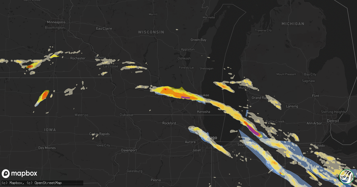
Hail Map on June 13, 2022
Get this storm
June 13 map
$229
one time, instant access
Download today. No call, no setup
Keep the $229
Bought the map and want the full workflow? Apply the entire $229 to a subscription within 7 days. None of it is wasted.
Every map, not just this one
This buys you this map. Subscription and you get every map we run, in the markets you choose from a few cities to whole states to nationwide. Plus real-time alerts the moment a storm fires.
Contact data
Name, contact info, occupancy, even credit band for addresses in the footprint. You go from where it hit to who to call.
Become the source they trust
Unlimited branding weather history reports on demand. You already have the documented answer ready for the property owner, and you are the one who showed up with it.
Property data and RoofTrace estimates
Pull up any address you have got, its value and the exact code rules for that jurisdiction, straight from One Click Code. Then RoofTrace estimates the squares, pitch, and roof value, priced the way you price.
States Impacted by Hail Map on June 13, 2022
Storm reports
Maryland
| Date | Description |
|---|---|
| 06/13/20226:12 PM CDT | Trees blew down near the intersection of pettit way and md-190 river road. |
| 06/13/20226:10 PM CDT | Tree down on river road near pettit way. |
| 06/13/20226:09 PM CDT | Tree down near the intersection of pettit way and md 190. |
| 06/13/20226:08 PM CDT | Tree and branches down on w willard road. |
| 06/13/20225:57 PM CDT | Trees and branches blew down down on west willard road. |
| 06/13/20226:43 AM CDT | Emergency management reports wires down in crumpton. Time estimated via radar. |
| 06/13/20224:02 AM CDT | At 902 PM EDT, a severe thunderstorm was located over Lake Ridge, or near Dale City, moving southeast at 20 mph. HAZARD...60 mph wind gusts and quarter size hail. SOURCE...Radar indicated. IMPACT...Damaging winds will cause some trees and large branches to fall. This could injure those outdoors, as well as damage homes and vehicles. Roadways may become blocked by downed trees. Localized power outages are possible. Unsecured light objects may become projectiles. Locations impacted include... Dale City, Woodbridge, Quantico, Lake Ridge, Montclair, Lorton, Triangle, Dumfries, Cherry Hill, Independent Hill, Bryans Road, Mason Neck, Potomac Heights, Marbury and Rison. |
| 06/13/20223:35 AM CDT | Trees blew down on eastbound alternate us-40 old national pike at dahlgren road. |
| 06/13/20223:30 AM CDT | Trees blew down on eastbound alternate us-40 old national pike near dahlgren road at the county line. |
| 06/13/20221:31 AM CDT | At 631 PM EDT, a severe thunderstorm was located near Poolesville, moving southeast at 20 mph. HAZARD...60 mph wind gusts and quarter size hail. SOURCE...Radar indicated. IMPACT...Damaging winds will cause some trees and large branches to fall. This could injure those outdoors, as well as damage homes and vehicles. Roadways may become blocked by downed trees. Localized power outages are possible. Unsecured light objects may become projectiles. Locations impacted include... Germantown, Lansdowne, Poolesville, Boyds, Belmont, Barnesville, Dickerson, Beallsville, Tuscarora and Lucketts. |
Iowa
| Date | Description |
|---|---|
| 06/13/20228:36 AM CDT | Time estimated from radar. |
| 06/13/20228:33 AM CDT | Image submitted via twitter. Size estimated based on photo. |
| 06/13/20228:24 AM CDT | Hail image submitted via twitter. Size and location both estimated. |
| 06/13/20228:15 AM CDT | A local report indicates 1.00 inch wind near KANAWHA |
| 06/13/20223:03 AM CDT | At 803 AM CDT, a severe thunderstorm was located 12 miles northwest of Clarion, moving northeast at 35 mph. HAZARD...60 mph wind gusts and quarter size hail. SOURCE...Radar indicated. IMPACT...Hail damage to vehicles is expected. Expect wind damage to roofs, siding, and trees. This severe thunderstorm will be near... Kanawha around 820 AM CDT.Other locations in the path of this severe thunderstorm includeGoodell, Eagle Lake, Klemme, Duncan, Eagle Lake State Park andGarner.This includes Interstate 35 between mile markers 177 and 181. |
| 06/13/20221:17 AM CDT | At 617 AM CDT, a severe thunderstorm was located near Osceola, moving east at 25 mph. HAZARD...60 mph wind gusts and quarter size hail. SOURCE...Radar indicated. IMPACT...Hail damage to vehicles is expected. Expect wind damage to roofs, siding, and trees. This severe thunderstorm will be near... Woodburn around 625 AM CDT.Other locations in the path of this severe thunderstorm includeLucas, Chariton Municipal Airport and Chariton.This includes Interstate 35 between mile markers 26 and 39. |
Wyoming
| Date | Description |
|---|---|
| 06/13/20226:57 PM CDT | A local report indicates 1.75 inch wind near 1 NNE KEELINE |
| 06/13/20222:17 AM CDT | At 717 PM MDT, a severe thunderstorm was located 8 miles southeast of Lusk, moving northeast at 30 mph. HAZARD...60 mph wind gusts and half dollar size hail. SOURCE...Radar indicated. IMPACT...Hail damage to vehicles is expected. Expect wind damage to roofs, siding, and trees. This severe thunderstorm will remain over mainly rural areas of northwestern Sioux and southeastern Niobrara Counties. |
| 06/13/20222:01 AM CDT | At 701 PM MDT, a severe thunderstorm was located 13 miles southeast of Redbird, or 19 miles southwest of Edgemont, moving northeast at 35 mph. HAZARD...Tennis ball size hail and 60 mph wind gusts. SOURCE...Radar indicated. IMPACT...People and animals outdoors will be injured. Expect hail damage to roofs, siding, windows, and vehicles. Expect wind damage to roofs, siding, and trees. Locations impacted include... Provo, Edgemont and Cascade Falls. |
| 06/13/20221:43 AM CDT | At 642 PM MDT, a severe thunderstorm was located 18 miles south of Redbird, or 18 miles northeast of Lusk, moving northeast at 35 mph. HAZARD...Golf ball size hail and 60 mph wind gusts. SOURCE...Radar indicated. IMPACT...People and animals outdoors will be injured. Expect hail damage to roofs, siding, windows, and vehicles. Expect wind damage to roofs, siding, and trees. Locations impacted include... Mule Creek Junction and Redbird. |
| 06/13/20221:17 AM CDT | At 617 PM MDT, a severe thunderstorm was located near Keeline, or 15 miles west of Lusk, moving northeast at 40 mph. HAZARD...60 mph wind gusts and half dollar size hail. SOURCE...Radar indicated. IMPACT...Hail damage to vehicles is expected. Expect wind damage to roofs, siding, and trees. Locations impacted include... Manville and Keeline. |
| 06/13/202212:56 AM CDT | At 556 PM MDT, a severe thunderstorm was located 12 miles southwest of Redbird, moving northeast at 35 mph. HAZARD...60 mph wind gusts and quarter size hail. SOURCE...Radar indicated. IMPACT...Hail damage to vehicles is expected. Expect wind damage to roofs, siding, and trees. Locations impacted include... Mule Creek Junction, Lance Creek and Redbird. |
| 06/13/202212:36 AM CDT | At 536 PM MDT, a severe thunderstorm was located 7 miles south of Keeline, or 19 miles southwest of Lusk, moving northeast at 25 mph. HAZARD...60 mph wind gusts and quarter size hail. SOURCE...Radar indicated. IMPACT...Hail damage to vehicles is expected. Expect wind damage to roofs, siding, and trees. Locations impacted include... Manville and Keeline. |
| 06/12/20229:52 PM CDT | A local report indicates 1.00 inch wind near 7 SSE SUNDANCE |
| 06/12/20228:42 PM CDT | A local report indicates 1.00 inch wind near 10 N VAN TASSELL |
| 06/12/20228:17 PM CDT | Hailstones ranged in size from marbles to golf balls. |
| 06/12/20227:35 PM CDT | Hailstones 1.5 to 2 inches in diameter. |
| 06/12/20227:00 PM CDT | Mostly quarter size hailstones... With a few hailstones from 2 to 2.5 inches in diameter. |
West Virginia
| Date | Description |
|---|---|
| 06/13/20228:15 AM CDT | Tree down. |
| 06/13/20226:14 AM CDT | At 1111 PM EDT, severe thunderstorms were located along a line extending from 9 miles southeast of Cass Scenic Railroad to near Pearisburg, moving southeast at 30 mph. HAZARD...70 mph wind gusts. SOURCE...Radar indicated. At 10:45PM a downed tree was reported in Rainelle, West Virginia. IMPACT...Expect considerable tree damage. Damage is likely to mobile homes, roofs, and outbuildings. Locations impacted include... Blacksburg... Christiansburg... Alleghany... Covington... Clifton Forge... Lewisburg... and Pearisburg.This includes The following locations Virginia Tech and the West Virginia State Fairgrounds. |
| 06/13/20225:44 AM CDT | At 1043 PM EDT, severe thunderstorms were located along a line extending from near Camp Creek to near Tiptop, moving southeast at 30 mph. HAZARD...70 mph wind gusts. SOURCE...Radar indicated. IMPACT...Expect considerable tree damage. Damage is likely to mobile homes, roofs, and outbuildings. Locations impacted include... Bluefield... Pulaski... Wytheville... Bland... Princeton... Tazewell... and Narrows.This includes the following location, the Mercer County Airport. |
| 06/13/20225:01 AM CDT | At 1000 PM EDT, severe thunderstorms were located along a line extending from near Clay to near Burnwell to near Amherstdale-Robinette, moving east at 45 mph. HAZARD...60 mph wind gusts and penny size hail. SOURCE...Radar indicated. IMPACT...Expect damage to roofs, siding, and trees. Locations impacted include... Beckley, Summersville, Fayetteville, Richwood, Pineville, Babcock State Park, Oak Hill, Mullens, Mount Hope, Mabscott, Ansted, Oceana, Sophia, Piney View, Coal City, Prosperity, Crab Orchard, Dry Creek, Macarthur and Bradley.This includes the following highways... West Virginia Turnpike between mile markers 28 and 60. Interstate 64 in West Virginia between mile markers 120 and 137. Route 19 between mile markers 1 and 52. |
| 06/13/20224:34 AM CDT | At 931 PM EDT, severe thunderstorms were located along a line extending from 6 miles north of Cedar Grove to 7 miles west of Burnwell to 7 miles west of Van, moving southeast at 35 mph. HAZARD...60 mph wind gusts and penny size hail. SOURCE...Radar indicated. IMPACT...Damage to roofs, siding, and trees is possible. Locations impacted include... Beckley, Summersville, Fayetteville, Babcock State Park, Oak Hill, Montgomery, Chesapeake, Marmet, Mount Hope, Mabscott, Ansted, Sophia, Belle, Cedar Grove, East Bank, Glasgow, Smithers, Gauley Bridge, Pratt and Van.This includes the following highways... West Virginia Turnpike between mile markers 41 and 89. Route 19 between mile markers 1 and 44. |
| 06/13/20224:12 AM CDT | At 911 PM EDT, severe thunderstorms were located along a line extending from near Arnoldsburg to 6 miles southeast of Pinch to near Alum Creek, moving east at 45 mph. HAZARD...70 mph wind gusts and nickel size hail. SOURCE...Radar indicated. IMPACT...Expect considerable tree damage. Damage is likely to mobile homes, roofs, and outbuildings. Locations impacted include... Charleston, Nitro, Madison, Winfield, Hamlin, Clay, Jefferson, South Charleston, St. Albans, Dunbar, Hurricane, Sissonville, Montgomery, Chesapeake, Marmet, Belle, Clendenin, Cedar Grove, Poca and East Bank.This includes the following highways... Interstate 79 between mile markers 1 and 55. Interstate 77 in West Virginia between mile markers 96 and 131. Interstate 64 in West Virginia between mile markers 35 and 57. West Virginia Turnpike between mile markers 62 and 95. Route 119 between mile markers 43 and 80. |
| 06/13/20224:06 AM CDT | At 905 PM EDT, severe thunderstorms were located along a line extending from near Vienna to near Elizabeth to 7 miles west of Spencer, moving east at 55 mph. HAZARD...60 mph wind gusts and quarter size hail. SOURCE...Radar indicated. IMPACT...Hail damage to vehicles is possible. Expect wind damage to roofs, siding, and trees. Locations impacted include... Parkersburg, Marietta, Belpre, Spencer, Harrisville, St. Marys, Glenville, Elizabeth, Grantsville, Vienna, Williamstown, Pennsboro, Belmont, Mineralwells, Arnoldsburg, Cedar Creek State Park, North Bend State Park, Boaz, Newport and North Hills.This includes the following highways... Interstate 77 in West Virginia near mile marker 128, and between mile markers 161 and 186. Route 50 in West Virginia between mile markers 5 and 50. |
| 06/13/20224:01 AM CDT | At 859 PM EDT, severe thunderstorms were located along a line extending from near Barboursville to Denton, moving southeast at 40 mph. HAZARD...60 mph wind gusts and penny size hail. SOURCE...Radar indicated. IMPACT...Expect damage to roofs, siding, and trees. Locations impacted include... Louisa, Logan, Wayne, Beech Fork State Park, Yatesville Lake State Park, Chapmanville, Fort Gay, Ranger, Burnaugh, Mount Gay-Shamrock, Harts, Gill, Durbin, Ulysses, East Lynn Lake, Charley, Centerville, Webbville, Spurlockville and Chief Logan State.This includes Route 119 between mile markers 1 and 48. |
| 06/13/20223:44 AM CDT | At 843 PM EDT, severe thunderstorms were located along a line extending from 8 miles northwest of Coolville to near Forked Run State Park to 8 miles south of Racine, moving northeast at 65 mph. HAZARD...60 mph wind gusts and nickel size hail. SOURCE...Radar indicated. IMPACT...Expect damage to roofs, siding, and trees. Locations impacted include... Parkersburg, Marietta, Belpre, Ripley, Spencer, St. Marys, Elizabeth, Coolville, Forked Run State Park, Vienna, Ravenswood, Williamstown, Belmont, Sandyville, Washington, Mineralwells, Tuppers Plains, Lubeck, Boaz and Newport.This includes the following highways... Interstate 77 in West Virginia between mile markers 137 and 186. Route 50 in West Virginia between mile markers 1 and 28. |
| 06/13/20222:07 AM CDT | At 707 PM EDT, a severe thunderstorm was located over Barboursville, or near Proctorville, moving east at 25 mph. HAZARD...60 mph wind gusts and quarter size hail. SOURCE...Radar indicated. IMPACT...Hail damage to vehicles is expected. Expect wind damage to roofs, siding, and trees. Locations impacted include... Huntington, Hamlin, Chesapeake, Proctorville, Barboursville, Milton, Ona, Culloden, Burlington, Athalia, Scottown, Salt Rock, Pea Ridge and Green Bottom.This includes Interstate 64 in West Virginia between mile markers 7and 31. |
| 06/13/20221:01 AM CDT | 3-inch tree limbs broken; power poles broken. |
| 06/13/202212:17 AM CDT | Report of multiple downed trees on west alexander road... Utility trailers pushed up against each other... And roof damage. |
| 06/13/202212:16 AM CDT | Multiple trees and untility poles down |
| 06/13/202212:15 AM CDT | Damage to roof and structure... And numerous downed trees. |
| 06/13/202212:11 AM CDT | Structural damage reported from thunderstorm wind on the eastern side of town. Wv dhhr building on 16th st reportedly lost roof panels... Homes lost siding and shingles |
| 06/13/202212:11 AM CDT | Structure fire in downtown wheeling due to wind damage to utility lines. |
| 06/13/202212:10 AM CDT | Numerous trees and large branches down across wheeling city center |
| 06/12/20229:50 PM CDT | A powerline was blown down by thunderstorm winds along coal heritage road. |
| 06/12/20229:45 PM CDT | Trees uprooted or snapped. Time estimated from radar. |
| 06/12/20229:45 PM CDT | Report from mping: trees uprooted or snapped. Time estimated from radar. |
| 06/12/20229:45 PM CDT | Tree down on route 20 south of rainelle. |
| 06/12/20229:45 PM CDT | Multiple trees were blown down by thunderstorm winds along a stretch of friars hill road. |
| 06/12/20229:27 PM CDT | Multiple trees down on walkers branch rd. |
| 06/12/20229:25 PM CDT | Tree down. |
| 06/12/20229:25 PM CDT | Trees down. |
| 06/12/20229:23 PM CDT | Tree down. |
| 06/12/20229:23 PM CDT | Tree down. |
| 06/12/20229:23 PM CDT | Tree down. |
| 06/12/20229:21 PM CDT | Trees down. |
| 06/12/20229:18 PM CDT | Several trees down. |
| 06/12/20229:15 PM CDT | Couple of trees down around alum creek. Time is a radar estimate. |
| 06/12/20228:56 PM CDT | Trees and powerlines down. |
| 06/12/20228:55 PM CDT | Trees down. |
| 06/12/20228:51 PM CDT | Clay county cert reports two trees and power lines down on route 36 wallback road. |
| 06/12/20228:35 PM CDT | Few trees down. Time is radar estimated. |
| 06/12/20228:35 PM CDT | Tree down. |
| 06/12/20228:32 PM CDT | Tree down. |
| 06/12/20228:30 PM CDT | Tree down at center street/pratt ave. |
| 06/12/20228:30 PM CDT | Tree down. Time is radar estimated. |
| 06/12/20228:28 PM CDT | Multiple trees down. |
| 06/12/20228:27 PM CDT | Multiple trees down. |
| 06/12/20228:26 PM CDT | Multiple trees down. |
| 06/12/20228:25 PM CDT | Tree down. |
| 06/12/20228:25 PM CDT | Tree down. |
| 06/12/20228:23 PM CDT | Tree down. |
| 06/12/20228:20 PM CDT | Tree down. |
| 06/12/20228:20 PM CDT | Tree down. |
| 06/12/20228:20 PM CDT | 2 trees down. |
| 06/12/20228:20 PM CDT | Tree down. |
| 06/12/20228:20 PM CDT | Tree down. Lake wayne wv 3806 8243 trees down. |
| 06/12/20228:15 PM CDT | Couple of trees down around alum creek. Time is a radar estimate. |
| 06/12/20228:15 PM CDT | Tree down. |
| 06/12/20228:15 PM CDT | Corrects previous tstm wnd dmg report from 9 wsw whitesville. Tree down. |
| 06/12/20228:15 PM CDT | Tree down. |
| 06/12/20228:15 PM CDT | Tree down. |
| 06/12/20228:15 PM CDT | Tree down. |
| 06/12/20228:15 PM CDT | Tree down. |
| 06/12/20228:14 PM CDT | Report from mping: trees uprooted or snapped. |
| 06/12/20228:12 PM CDT | Tree down. |
| 06/12/20228:11 PM CDT | Spotter reports tree down on atkinson ridge road... With many power outages. Time estimated from radar. |
| 06/12/20228:11 PM CDT | Trees down. |
| 06/12/20228:10 PM CDT | Tree reported down on i-77 at mile marker 98 via wv 511. Time estimated by radar. |
| 06/12/20228:06 PM CDT | A local report indicates 1.00 inch wind near 4 NNW WEST HAMLIN |
| 06/12/20228:05 PM CDT | Trees and powerlines down. |
| 06/12/20228:00 PM CDT | Tree down in road. |
| 06/12/20228:00 PM CDT | Corrects previous tstm wnd dmg report from 1 ssw cross lanes. Tree down. |
| 06/12/20228:00 PM CDT | Tree down. |
| 06/12/20228:00 PM CDT | Tree down. |
| 06/12/20227:55 PM CDT | Tree blocking buck run road... Reported via social media. Time estimated from radar. |
| 06/12/20227:53 PM CDT | Large limbs down. Power out. |
| 06/12/20227:53 PM CDT | Trained spotter reports tree down on state route 68. Time estimated from radar. |
| 06/12/20227:45 PM CDT | Corrects previous tstm wnd dmg report from 5 ene leon. Trees uprooted or snapped. Time estimated from radar. |
| 06/12/20227:45 PM CDT | Tree down in road. |
| 06/12/20227:42 PM CDT | Multiple trees down. |
| 06/12/20227:42 PM CDT | Large tree down on ashton street. Time estimated from radar. |
| 06/12/20227:40 PM CDT | Trees down. |
| 06/12/20227:38 PM CDT | Trees uprooted or snapped; roof blown off. |
| 06/12/20227:35 PM CDT | Tree reported down on i-64 westbound by wv 511. Time estimated from radar. |
| 06/12/20227:25 PM CDT | Multiple trees down along morris street. |
| 06/12/20227:25 PM CDT | Tree down. |
Pennsylvania
| Date | Description |
|---|---|
| 06/13/20226:40 AM CDT | Em reports trees/wires down at the intersection of us route 1 and state route 352. Road closed at time of report. Time estimated via radar. |
| 06/13/202212:34 AM CDT | Cove road blocked due to downed tree landing on road and power lines. Time estimated based on radar. |
Wisconsin
| Date | Description |
|---|---|
| 06/13/20224:39 PM CDT | At mke. Also had half inch hail. |
| 06/13/20224:30 PM CDT | A local report indicates 1.25 inch wind near FRANKLIN |
| 06/13/20224:30 PM CDT | Numerous trees and branches down. Time est from radar. |
| 06/13/20224:26 PM CDT | Size est from social media pic. |
| 06/13/20224:20 PM CDT | Tree damage. Time est by radar. |
| 06/13/20224:16 PM CDT | A local report indicates 1.00 inch wind near 2 SE WAUKESHA |
| 06/13/20224:15 PM CDT | A local report indicates 60 MPH wind near 2 N MUSKEGO |
| 06/13/20224:12 PM CDT | Report is from vernon. |
| 06/13/20224:03 PM CDT | Size est from social media pic. Time est from radar. |
| 06/13/20224:03 PM CDT | From social media pic. Time est from radar. |
| 06/13/20224:02 PM CDT | Time est from radar. H |
| 06/13/20224:02 PM CDT | Time est from radar. |
| 06/13/20224:00 PM CDT | Widespread reports of trees and wires down across much of western waukesha county. |
| 06/13/20224:00 PM CDT | A local report indicates 1.00 inch wind near 3 SSE DOUSMAN |
| 06/13/20223:56 PM CDT | Report from mping: golf ball |
| 06/13/20223:55 PM CDT | Large tree snapped near base. Time est from radar. |
| 06/13/20223:55 PM CDT | Largest stone was 2 inches...measured. Corrects previous hail report from 4 sse sullivan. At wfo mkx. |
| 06/13/20223:55 PM CDT | Certified weather observer. |
| 06/13/20223:47 PM CDT | Size est from social media pic. Time est from radar. |
| 06/13/20223:44 PM CDT | 1 e of helenville. |
| 06/13/20223:42 PM CDT | A local report indicates 1.25 inch wind near 2 SW WATERTOWN |
| 06/13/20223:40 PM CDT | A local report indicates 1.75 inch wind near 4 E JEFFERSON |
| 06/13/20223:35 PM CDT | 50-60 mph gusts. |
| 06/13/20223:34 PM CDT | Report from mping: golf ball |
| 06/13/20223:25 PM CDT | Widespread tree damage across lake mills. Time est from radar. |
| 06/13/20223:15 PM CDT | Picture on social media. |
| 06/13/20223:10 PM CDT | Size est from social media pic. |
| 06/13/20223:10 PM CDT | Report from mping: ping pong ball |
| 06/13/20223:08 PM CDT | Report from mping: ping pong ball |
| 06/13/20223:08 PM CDT | Estimated 2.25 inch from social media image. |
| 06/13/20223:08 PM CDT | Mping. |
| 06/13/20223:05 PM CDT | Mping report. |
| 06/13/20223:02 PM CDT | A local report indicates 1.00 inch wind near 2 E MAPLE BLUFF |
| 06/13/20223:00 PM CDT | Report from mping: half dollar |
| 06/13/20222:57 PM CDT | Numerous trees and power poles down near the monona golf course. Large limbs snapped off trees. |
| 06/13/20222:55 PM CDT | Numerous trees and powerlines down. Debris flying past windows on 8th story of office building. |
| 06/13/20222:53 PM CDT | Roof damage to an apartment complex on wright street. Time est by radar. |
| 06/13/20222:50 PM CDT | Numerous reports of trees and wires down along with blown transformers across the western portion of madison and middleton. |
| 06/13/20222:47 PM CDT | Report from mping: quarter |
| 06/13/20226:31 AM CDT | At 1131 AM CDT, a severe thunderstorm was located near Monroe, moving northeast at 50 mph. HAZARD...Quarter size hail. SOURCE...Radar indicated. IMPACT...Damage to vehicles is expected. Locations impacted include... Monroe, Brooklyn, Monticello, Albany, Dayton, Browntown, Attica and Jordan Center. |
| 06/12/202211:08 PM CDT | At 408 PM CDT, a severe thunderstorm was located over Waukesha, moving east at 50 mph. HAZARD...Golf ball size hail and 60 mph wind gusts. SOURCE...Radar indicated. IMPACT...People and animals outdoors will be injured. Expect hail damage to roofs, siding, windows, and vehicles. Expect wind damage to roofs, siding, and trees. Locations impacted include... Milwaukee, West Allis, Wauwatosa, Greenfield, Oak Creek, South Milwaukee, Cudahy, Whitefish Bay, Greendale, Brown Deer, St. Francis, Hales Corners, Fox Point, Bayside, West Milwaukee, Franklin, Glendale, Wind Lake, Raymond and Wind Point.This includes the following Locations Schlitz Audobon Nature Center,Boerner Botanical Gardens, General Mitchell International Airport,Timmerman Airport, Froedert & the Medical College, and Fiserv Forum. |
| 06/12/202210:38 PM CDT | At 337 PM CDT, a severe thunderstorm was located near Johnson Creek, or near Jefferson, moving east at 45 mph. HAZARD...Golf ball size hail and 70 mph wind gusts. SOURCE...Radar indicated. IMPACT...People and animals outdoors will be injured. Expect hail damage to roofs, siding, windows, and vehicles. Expect considerable tree damage. Wind damage is also likely to mobile homes, roofs, and outbuildings. Locations impacted include... Waukesha, New Berlin, Brookfield, Menomonee Falls, Muskego, Pewaukee, Sussex, Hartland, Mukwonago, Delafield, Elm Grove, Wales, Okauchee Lake, Oconomowoc, Lisbon, Vernon, Ottawa, Merton, Dousman and North Prairie.This includes the following Locations Pewaukee Lake, Ottawa LakeRecreation Area, and Pinewoods Campground. |
| 06/12/202210:18 PM CDT | At 317 PM CDT, a severe thunderstorm was located near Mauston, moving east at 40 mph. HAZARD...Half dollar size hail. SOURCE...Radar indicated. IMPACT...Damage to vehicles is expected. This severe thunderstorm will remain over mainly rural areas of southeastern Juneau and southern Adams Counties, including the following locations... County Roads B And P, Dells Timberland Campground, County Roads B And K, The Town Of Quincy, Lyndon Station, Stand Rock Campground and Big Spring.This includes Interstate 90/94 between mile markers 75 and 86. |
| 06/12/20229:59 PM CDT | At 259 PM CDT, a severe thunderstorm was located over Windsor, moving east at 40 mph. HAZARD...Golf ball size hail and 60 mph wind gusts. SOURCE...Radar indicated. IMPACT...People and animals outdoors will be injured. Expect hail damage to roofs, siding, windows, and vehicles. Expect wind damage to roofs, siding, and trees. Locations impacted include... Eastern Madison, Sun Prairie, Fitchburg, Watertown, Stoughton, Fort Atkinson, Oregon, Jefferson, McFarland, Monona, Lake Mills, Marshall, Waterloo, Cottage Grove, Johnson Creek, Deerfield, Cambridge, Lake Ripley, Ixonia and Rome. |
| 06/12/20229:44 PM CDT | At 244 PM CDT, a severe thunderstorm was located over Middleton, moving east at 45 mph. HAZARD...60 mph wind gusts and quarter size hail. SOURCE...Radar indicated. IMPACT...Hail damage to vehicles is expected. Expect wind damage to roofs, siding, and trees. Locations impacted include... Madison, Middleton, Monona, Cross Plains, Shorewood Hills, Maple Bluff, Pine Bluff, Henry Vilas Zoo, Camp Randall Stadium and UW- Madison.This includes the following Location Wisconsin State Capitol. |
| 06/12/20229:43 PM CDT | At 243 PM CDT, a severe thunderstorm was located 9 miles east of Cashton, or 14 miles south of Tomah, moving east at 45 mph. HAZARD...Half dollar size hail. SOURCE...Radar indicated. IMPACT...Damage to vehicles is expected. This severe thunderstorm will be near... Elroy around 305 PM CDT. Mauston and New Lisbon around 315 PM CDT.Other locations impacted by this severe thunderstorm include OilCity, St Marys, Wilton, Clifton, Lindina, Johnson Hill and Glendale.This includes Interstate 90/94 between mile markers 56 and 75. |
| 06/12/20229:16 PM CDT | At 216 PM CDT, a severe thunderstorm was located near Mazomanie, or 7 miles west of Sauk City, moving east at 35 mph. HAZARD...Quarter size hail. SOURCE...Radar indicated. IMPACT...Damage to vehicles is expected. Locations impacted include... Eastern Madison, Sun Prairie, Waunakee, Portage, Windsor, Sauk City, Lake Wisconsin, Deforest, Lodi, Poynette, Mazomanie, Black Earth, Dane, Arlington, Merrimac, Harmony Grove, Morrisonville, Token Creek, Okee and Interstate 90/94 Interchange.This includes the following Location Gibraltar Rock Natural AreaCounty Park. |
| 06/12/20228:56 PM CDT | At 156 PM CDT, a severe thunderstorm was located near Spring Green, or 15 miles east of Richland Center, moving east at 45 mph. HAZARD...Quarter size hail. SOURCE...Radar indicated. IMPACT...Damage to vehicles is expected. Locations impacted include... Baraboo, Prairie Du Sac, Sauk City, Spring Green, West Baraboo, Plain, Bluffview, North Freedom, Merrimac and Devils Lake St Park. |
North Dakota
| Date | Description |
|---|---|
| 06/13/20226:28 AM CDT | At 1128 PM CDT, a severe thunderstorm was located over Cathay, or 15 miles northwest of Carrington, moving northeast at 30 mph. HAZARD...70 mph wind gusts and half dollar size hail. SOURCE...Radar indicated. IMPACT...Hail damage to vehicles is expected. Expect considerable tree damage. Wind damage is also likely to mobile homes, roofs, and outbuildings. This severe thunderstorm will remain over mainly rural areas of eastern Wells and western Foster Counties, including the following locations... Emrick, Bremen, Melville, Heaton, Hamberg, Barlow and Sykeston. |
| 06/13/20226:08 AM CDT | At 1107 PM CDT, a severe thunderstorm was located over Bremen, or 36 miles southwest of Devils Lake, moving east at 20 mph. HAZARD...70 mph wind gusts and ping pong ball size hail. SOURCE...Radar indicated. IMPACT...People and animals outdoors will be injured. Expect hail damage to roofs, siding, windows, and vehicles. Expect considerable tree damage. Wind damage is also likely to mobile homes, roofs, and outbuildings. Locations impacted include... New Rockford. |
| 06/13/20226:00 AM CDT | Extensive tree damage with many evergreen and deciduous trees blown down. |
| 06/13/20225:56 AM CDT | At 1055 PM CDT, a severe thunderstorm was located 6 miles east of Fessenden, or 21 miles northwest of Carrington, moving northeast at 35 mph. HAZARD...60 mph wind gusts and half dollar size hail. SOURCE...Radar indicated. IMPACT...Hail damage to vehicles is expected. Expect wind damage to roofs, siding, and trees. This severe thunderstorm will remain over mainly rural areas of Wells County, including the following locations... Chaseley, Emrick, Bremen, Heaton, Hamberg, Heimdal, Bowdon and Sykeston. |
| 06/13/20225:51 AM CDT | At 1051 PM CDT, severe thunderstorms were located along a line extending from near Egeland to near Churchs Ferry, moving east at 35 mph. HAZARD...70 mph wind gusts and quarter size hail. SOURCE...Radar indicated. IMPACT...Hail damage to vehicles is expected. Expect considerable tree damage. Wind damage is also likely to mobile homes, roofs, and outbuildings. Severe thunderstorms will be near... Calio around 1105 PM CDT. Webster, Garske and Clyde around 1110 PM CDT.Other locations in the path of these severe thunderstorms includeMunich, Alsen and Loma. |
| 06/13/20225:50 AM CDT | Extensive tree damage with snapped and uprooted trees throughout the city of adrian. |
| 06/13/20225:45 AM CDT | Social media report of large trees uprooted in dickey. Time estimated by radar. |
| 06/13/20225:26 AM CDT | Roof ripped off down to rafters - radar estimated time. |
| 06/13/20225:21 AM CDT | Radar estimated time. |
| 06/13/20225:20 AM CDT | Dickey county emergency manager reported numerous tre |
| 06/13/20225:20 AM CDT | Dickey county emergency manager reported numerous trees and powerlines downed in the city of ellendale. Quarter sized hail was also reported. |
| 06/13/20225:20 AM CDT | A local report indicates 1.00 inch wind near ELLENDALE |
| 06/13/20225:15 AM CDT | At 1015 PM CDT, a severe thunderstorm was located over Selz, or 48 miles west of Devils Lake, moving east at 35 mph. HAZARD...Golf ball size hail and 60 mph wind gusts. SOURCE...Radar indicated. IMPACT...People and animals outdoors will be injured. Expect hail damage to roofs, siding, windows, and vehicles. Expect wind damage to roofs, siding, and trees. Locations impacted include... Maddock and Flora. |
| 06/13/20225:00 AM CDT | Facebook photo of a hailstone measured to be about 3 inches in diameter. Relayed by broadcast media. The reporter says that cars have dents and expects to find damage t |
| 06/13/20224:54 AM CDT | At 954 PM CDT, severe thunderstorms were located along a line extending from 5 miles southwest of Esmond to 7 miles north of Goodrich to 6 miles northwest of Regan, moving east at 40 mph. HAZARD...70 mph wind gusts and half dollar size hail. SOURCE...Radar indicated. IMPACT...Hail damage to vehicles is expected. Expect considerable tree damage. Wind damage is also likely to mobile homes, roofs, and outbuildings. Locations impacted include... Fessenden and Hurdsfield. |
| 06/13/20223:57 AM CDT | At 856 PM CDT, a severe thunderstorm was located 7 miles north of Washburn, moving northeast at 35 mph. HAZARD...60 mph wind gusts and penny size hail. SOURCE...Radar indicated. IMPACT...Expect damage to roofs, siding, and trees. This severe thunderstorm will be near... Turtle Lake around 910 PM CDT.Other locations in the path of this severe thunderstorm includeMercer and Mcclusky. |
| 06/13/20223:54 AM CDT | At 853 PM CDT, severe thunderstorms were located along a line extending from 4 miles south of Denbigh to 6 miles northeast of Karlsruhe to 10 miles west of Drake to near Butte to 12 miles northeast of Turtle Lake, moving east at 30 mph. HAZARD...60 mph wind gusts. SOURCE...Radar indicated. IMPACT...Expect damage to roofs, siding, and trees. Severe thunderstorms will be near... Denbigh around 900 PM CDT.Other locations in the path of these severe thunderstorms includeTowner, Drake, Anamoose, Balta, Rugby and Martin. |
| 06/13/20223:02 AM CDT | At 801 PM CDT, severe thunderstorms were located along a line extending from 4 miles southeast of Minot to 4 miles west of Benedict to near Coleharbor, moving east at 35 mph. HAZARD...70 mph wind gusts and nickel size hail. SOURCE...Radar indicated. IMPACT...Expect considerable tree damage. Damage is likely to mobile homes, roofs, and outbuildings. Severe thunderstorms will be near... Surrey, Sawyer and Benedict around 810 PM CDT.Other locations in the path of these severe thunderstorms includeTurtle Lake, Granville, Butte, Mercer, Denbigh, Towner and Drake. |
| 06/13/20222:14 AM CDT | At 713 PM CDT, a severe thunderstorm was located near Roseglen, or 23 miles west of Garrison, moving northeast at 40 mph. HAZARD...60 mph wind gusts and half dollar size hail. SOURCE...Radar indicated. IMPACT...Hail damage to vehicles is expected. Expect wind damage to roofs, siding, and trees. This severe thunderstorm will be near... Roseglen around 720 PM CDT.Other locations in the path of this severe thunderstorm includeRyder, Douglas and Rice Lake. |
| 06/13/20221:24 AM CDT | At 624 PM CDT/524 PM MDT/, a severe thunderstorm was located 7 miles southeast of Mandaree, or 19 miles north of Killdeer, moving northeast at 45 mph. HAZARD...60 mph wind gusts and quarter size hail. SOURCE...Radar indicated. IMPACT...Hail damage to vehicles is expected. Expect wind damage to roofs, siding, and trees. Locations impacted include... Parshall and Plaza. |
| 06/13/202212:56 AM CDT | At 555 PM CDT/455 PM MDT/, a severe thunderstorm was located 9 miles west of Killdeer, moving east at 35 mph. HAZARD...60 mph wind gusts and quarter size hail. SOURCE...Radar indicated. IMPACT...Hail damage to vehicles is expected. Expect wind damage to roofs, siding, and trees. This severe thunderstorm will be near... Killdeer around 510 PM MDT.Other locations in the path of this severe thunderstorm include DunnCenter, Little Missouri State Park and Mckenzie Bay Recreation Area. |
| 06/12/202211:55 PM CDT | Devils lake cwop wind gust of 59 mph at 1155 pm. |
| 06/12/202211:15 PM CDT | Corrects previous tstm wnd gst report from 3 sw oberon. Davis personal weather station 2 miles south and 3 miles west of oberon recorded 61 mph wind gust. |
| 06/12/202211:05 PM CDT | Davis personal weather station 2 miles south and 3 miles west of oberon recorded 61 mph wind gust. |
| 06/12/202210:20 PM CDT | Pictures submitted via facebook showing estimated quarter sized hail. Reporter also estimated 60 mph wind gusts and 1.30 inches of rain. |
| 06/12/202210:16 PM CDT | A local report indicates 1.00 inch wind near HARVEY |
| 06/12/202210:15 PM CDT | Seven evergreen trees were uprooted at the harvey golf course. |
| 06/12/202210:12 PM CDT | Ndawn station harvey 2sw. Sustained at 43 mph. |
| 06/12/202210:09 PM CDT | Radar estimated time. |
| 06/12/202210:09 PM CDT | 10 inch in diameter apple tree snapped. Radar estimated time - report relayed via social media. |
| 06/12/202210:05 PM CDT | Late report from last nights storm. |
| 06/12/20229:55 PM CDT | Multiple trees were uprooted or severely damaged in martin and the surrounding area. One tree fell onto a structure... Breaking through the roof and eaves. |
| 06/12/20229:50 PM CDT | A local report indicates 1.75 inch wind near 7 WSW SHEYENNE LAKE |
| 06/12/20229:35 PM CDT | A camper was flipped onto its roof. Time estimated from radar. |
| 06/12/20228:00 PM CDT | Delayed report from severe weather on the night of june 13. Time estimated from radar. |
| 06/12/20227:57 PM CDT | Asos station kn60 garrison. |
| 06/12/20227:55 PM CDT | Relayed through social media. Time estimated from radar. |
| 06/12/20227:29 PM CDT | Ndawn station garrison 13nw. Sustained wind 41 mph. |
| 06/12/20227:25 PM CDT | A shed was destroyed... With the roof blown well away from the shed. |
| 06/12/20227:05 PM CDT | Storm report from last night. Power lines were blown down in the raub area. Information relayed by broadcast media. |
South Carolina
| Date | Description |
|---|---|
| 06/13/20226:10 PM CDT | A tree fell on a house. At least a few other trees down in the walhalla area. |
| 06/13/20225:45 PM CDT | At least 2 trees down near salem. |
| 06/13/20225:16 PM CDT | Sc highway patrol reported trees down at the intersection of 764 and 601. Time estimated from radar. |
| 06/13/202212:53 AM CDT | At 553 PM EDT, a severe thunderstorm was located near Eastover, or 7 miles east of McEntire Air Base, moving south at 5 mph. HAZARD...60 mph wind gusts. SOURCE...Radar indicated. IMPACT...Expect damage to trees and powerlines. Locations impacted include... Eastover, Gadsden and Wedgewood. |
Kentucky
| Date | Description |
|---|---|
| 06/13/20226:50 PM CDT | Corrects previous tstm wnd dmg report from greenup. Corrects previous tstm wnd dmg report from greenup. Corrects previous tstm wnd dmg report from greenup. Multiple tre |
| 06/13/20226:50 PM CDT | Multiple trees down. |
| 06/13/20226:50 PM CDT | Multiple trees down. |
| 06/13/20226:45 PM CDT | Multiple trees down. |
| 06/13/20226:45 PM CDT | Multiple trees down. |
| 06/13/20224:58 PM CDT | Wires down on new uri avenue. Time estimated from radar. |
| 06/13/20224:54 PM CDT | Wires down on limaburg road. |
| 06/13/20225:13 AM CDT | At 1013 PM EDT, a severe thunderstorm was located near Kiahsville, or 12 miles south of Wayne, moving southeast at 30 mph. HAZARD...60 mph wind gusts and penny size hail. SOURCE...Radar indicated. IMPACT...Expect damage to roofs, siding, and trees. Locations impacted include... Chapmanville, Ranger, Gill, Harts, Dunlow, Mount Gay-Shamrock, Holden, Dingess, Myrtle, Wilsondale, Lenore and Breeden.This includes Route 119 between mile markers 5 and 18, and betweenmile markers 29 and 39. |
| 06/13/20222:35 AM CDT | At 735 PM EDT, a severe thunderstorm was located over Clarktown, moving southeast at 50 mph. HAZARD...60 mph wind gusts. SOURCE...Radar indicated. IMPACT...Expect damage to trees and power lines. Locations impacted include... Portsmouth, Wheelersburg, New Boston, South Webster, Rosemount, Clarktown, Sciotodale, Franklin Furnace, Minford, Powellsville, Portsmouth Regional Airport and Lyra. |
| 06/13/20222:27 AM CDT | At 726 PM EDT, severe thunderstorms were located along a line extending from near Groveport to near Piketon to 6 miles northeast of Vanceburg, moving east at 55 mph. HAZARD...60 mph wind gusts and nickel size hail. SOURCE...Radar indicated. IMPACT...Expect damage to roofs, siding, and trees. Locations impacted include... Huntington, Athens, Ashland, Ironton, Jackson, Wellston, Nelsonville, New Lexington, Point Pleasant, Gallipolis, Coal Grove, Pomeroy, Glouster, Mcarthur, Oak Hill, Rio Grande, Albany, Chesapeake, Racine and Shawnee.This includes Interstate 64 in West Virginia between mile markers 11and 27. |
| 06/13/20222:00 AM CDT | At 700 PM EDT, severe thunderstorms were located along a line extending from near Kincaid Springs to near Manchester, moving east at 60 mph. HAZARD...60 mph wind gusts and penny size hail. SOURCE...Radar indicated. IMPACT...Expect damage to trees and power lines. Locations impacted include... Portsmouth, Wheelersburg, Waverly, West Union, New Boston, Piketon, Manchester, Peebles, South Webster, Rosemount, Clarktown, Rome, Lucasville, Sciotodale, Blue Creek, Beaver, Rarden, Otway, Locust Grove and Givens. |
| 06/13/20221:58 AM CDT | At 658 PM EDT, a severe thunderstorm was located near Georgetown, moving east at 50 mph. HAZARD...60 mph wind gusts and penny size hail. SOURCE...Radar indicated. IMPACT...Expect damage to trees and power lines. Locations impacted include... Maysville, Georgetown, Mount Orab, Bethel, Williamsburg, Ripley, Aberdeen, Augusta, Sardinia, Felicity, Decatur, Russellville, Hamersville, Dover, Higginsport, Moscow, Neville, Chilo, Willow Grove and Bradford. |
| 06/13/202212:55 AM CDT | At 555 PM EDT, a severe thunderstorm was located over Loveland, moving east at 20 mph. HAZARD...60 mph wind gusts. SOURCE...Radar indicated. IMPACT...Expect damage to trees and power lines. Locations impacted include... Georgetown, Mount Orab, Bethel, Williamsburg, Lynchburg, Sardinia, Felicity, Hamersville, Newtonsville, Fayetteville, St. Martin, Chilo, Chasetown, Greenbush, Lake Waynoka, Buford, State Route 32 at US Route 68, Point Isabel, Feesburg and New Hope. |
| 06/13/202212:27 AM CDT | At 527 PM EDT, a severe thunderstorm was located near Harrison, moving southeast at 45 mph. HAZARD...70 mph wind gusts and penny size hail. SOURCE...Radar indicated. IMPACT...Expect considerable tree damage. Damage is likely to mobile homes, roofs, and outbuildings. Locations impacted include... Cincinnati, Covington, Independence, Norwood, Forest Park, Erlanger, Fort Thomas, Newport, Sharonville, Blue Ash, Loveland, Springdale, Reading, Montgomery, North College Hill, Madeira, Edgewood, Alexandria, Elsmere and Wyoming.This includes the following Interstates... I-71 in Ohio between mile markers 0 and 19. I-74 in Ohio between mile markers 14 and 19. I-75 in Kentucky between mile markers 184 and 191. I-75 in Ohio between mile markers 0 and 17. |
| 06/13/202212:16 AM CDT | At 516 PM EDT, a severe thunderstorm was located over Brookville, moving southeast at 35 mph. HAZARD...70 mph wind gusts and penny size hail. SOURCE...Radar indicated. IMPACT...Expect considerable tree damage. Damage is likely to mobile homes, roofs, and outbuildings. Locations impacted include... Cincinnati, Florence, Harrison, Cheviot, Lawrenceburg, Greendale, Aurora, Rising Sun, Bright, Hidden Valley, Oakbrook, Burlington, Cleves, Milan, Dillsboro, Shawnee, Moores Hill, Taylor Creek, Bridgetown and Miami Heights.This includes the following Interstates... I-74 in Ohio between mile markers 1 and 14. I-75 in Kentucky between mile markers 181 and 182. |
| 06/12/20229:25 PM CDT | Multiple trees down. |
| 06/12/20229:11 PM CDT | Multiple trees down. |
| 06/12/20229:10 PM CDT | Multiple trees down. |
| 06/12/20229:10 PM CDT | Multiple trees down. |
| 06/12/20228:48 PM CDT | Multiple trees down. |
| 06/12/20228:45 PM CDT | Corrects previous tstm wnd dmg report from worthington. Multiple trees down. |
| 06/12/20228:45 PM CDT | Corrects previous tstm wnd dmg report from greenup. Multiple trees down. |
| 06/12/20228:45 PM CDT | Corrects previous tstm wnd dmg report from south shore. Multiple trees down. |
| 06/12/20228:44 PM CDT | Trees down. |
| 06/12/20228:36 PM CDT | Multiple trees down on oakview road. |
| 06/12/20228:30 PM CDT | Corrects previous tstm wnd dmg report from worthington. Corrects previous tstm wnd dmg report from worthington. Multiple trees down. |
| 06/12/20228:30 PM CDT | Corrects previous tstm wnd dmg report from greenup. Corrects previous tstm wnd dmg report from greenup. Multiple trees down. |
| 06/12/20228:30 PM CDT | Corrects previous tstm wnd dmg report from south shore. Corrects previous tstm wnd dmg report from south shore. Multiple trees down. |
| 06/12/20228:09 PM CDT | Multiple trees down on cactus street. |
| 06/12/20227:25 PM CDT | Trees down. |
| 06/12/20227:25 PM CDT | Multiple trees down on cactus street. |
| 06/12/20227:09 PM CDT | Multiple trees down on oakview road. |
| 06/12/20227:09 PM CDT | Multiple trees down on cactus street. |
Virginia
| Date | Description |
|---|---|
| 06/13/20226:27 PM CDT | A few trees and wires blew down in the reston/herndon area. |
| 06/13/20226:00 PM CDT | Tree down near the intersection of route 611 and chartwell lane. |
| 06/13/20225:59 PM CDT | Two trees blew down in the 3000 block of va-729 buck island road. |
| 06/13/20225:58 PM CDT | Tree down on cartners mountain road near grand cru drive. |
| 06/13/20225:55 PM CDT | Trees blew down on va-627 carters mountain road near grand cru drive. |
| 06/13/20225:40 PM CDT | Two trees blew down in the 3000 block of va-729 buck island road. |
| 06/13/202210:55 AM CDT | A large tree limb was blown down by thunderstorm winds across kirby road... Partially blocking the roadway. |
| 06/13/20225:02 AM CDT | At 1000 PM EDT, severe thunderstorms were located along a line extending from near Birch River to 8 miles northeast of Oceana, moving east at 35 mph. HAZARD...70 mph wind gusts. SOURCE...Radar indicated. IMPACT...Expect considerable tree damage. Damage is likely to mobile homes, roofs, and outbuildings. Locations impacted include... Lewisburg... Hinton... White Sulphur Springs... Narrows... Ronceverte... Rainelle... and Alderson.This includes The following Location The West Virginia StateFairgrounds. |
| 06/13/20224:06 AM CDT | Several large branches down. |
| 06/13/20223:55 AM CDT | Trees down along spring valley rd. As well as other portions of the county through 515 am. |
| 06/13/20223:41 AM CDT | Multiple trees down in tannersville. |
| 06/13/20223:40 AM CDT | Multiple trees down. |
| 06/13/20223:27 AM CDT | Multiple trees down. |
| 06/13/20223:27 AM CDT | At 826 PM EDT, a severe thunderstorm was located over Centreville, moving southeast at 25 mph. HAZARD...60 mph wind gusts and quarter size hail. SOURCE...Radar indicated. IMPACT...Damaging winds will cause some trees and large branches to fall. This could injure those outdoors, as well as damage homes and vehicles. Roadways may become blocked by downed trees. Localized power outages are possible. Unsecured light objects may become projectiles. Locations impacted include... Centreville, Dale City, Woodbridge, Lake Ridge, Burke, Chantilly, Montclair, Lorton, Newington, Manassas, Manassas Park, Fairfax Station, Independent Hill, Mason Neck, Occoquan and Clifton. |
| 06/13/20221:57 AM CDT | At 657 PM EDT, a severe thunderstorm was located over Poolesville, moving southeast at 30 mph. HAZARD...60 mph wind gusts and quarter size hail. SOURCE...Radar indicated. IMPACT...Damaging winds will cause some trees and large branches to fall. This could injure those outdoors, as well as damage homes and vehicles. Roadways may become blocked by downed trees. Localized power outages are possible. Unsecured light objects may become projectiles. Locations impacted include... Germantown, Rockville, Bethesda, Gaithersburg, Reston, Vienna, Lowes Island, Pimmit Hills, American Legion Bridge, Mclean, Potomac, North Bethesda, North Potomac, Tysons Corner, Wolf Trap, Great Falls, Merrifield, Countryside, Chevy Chase and North Kensington. |
| 06/13/20221:18 AM CDT | At 618 PM EDT, a severe thunderstorm was located near Crozet, or near Charlottesville, moving southeast at 20 mph. HAZARD...60 mph wind gusts and quarter size hail. SOURCE...Radar indicated. IMPACT...Damaging winds will cause some trees and large branches to fall. This could injure those outdoors, as well as damage homes and vehicles. Roadways may become blocked by downed trees. Localized power outages are possible. Unsecured light objects may become projectiles. Locations impacted include... Charlottesville, Crozet, Free Union, Campbell, Westmoreland, Hollymead, Ivy, Newcomb Hall, Boyd Tavern, Monticello, Woodridge, Keswick, Flordon, Carrsbrook, Shadwell, Barracks, Overton and Scott Stadium. |
| 06/13/202212:47 AM CDT | At 546 PM EDT, a severe thunderstorm was located near Big Meadows, or 15 miles northwest of Madison, moving southeast at 20 mph. HAZARD...60 mph wind gusts and quarter size hail. SOURCE...Radar indicated. IMPACT...Damaging winds will cause some trees and large branches to fall. This could injure those outdoors, as well as damage homes and vehicles. Roadways may become blocked by downed trees. Localized power outages are possible. Unsecured light objects may become projectiles. Locations impacted include... Criglersville, Banco, Slate Mills, Ida, Reva, Etlan, Nethers, Haywood, Aylor, Skyland and Syria. |
| 06/13/202212:10 AM CDT | Multiple trees down from woolwine to critz in patrick county. |
| 06/12/202211:55 PM CDT | Tree down along morning side drive. |
| 06/12/202211:28 PM CDT | Two tree limbs down in the bonsack area of roanoke county. Time estimated by radar. |
| 06/12/202211:20 PM CDT | Tree down across bethlehem church road. Time estimated by radar. |
| 06/12/202211:00 PM CDT | A large tree was uprooted on gold drive in christiansburg. Time estimated by radar. |
| 06/12/202210:55 PM CDT | A tree was blown down by thunderstorm winds along baker road. |
| 06/12/202210:50 PM CDT | A tree was blown down by thunderstorm winds near the intersection of ceres school road and the blue grass trail. |
| 06/12/202210:46 PM CDT | A tree was blown down along dora highway by thunderstorm winds. |
| 06/12/202210:45 PM CDT | A tree was blown down by thunderstorm winds along black hollow road. |
| 06/12/202210:45 PM CDT | A tree was blown down by thunderstorm winds along clover hollow road. |
| 06/12/202210:05 PM CDT | A tree was blown down by thunderstorm winds along the 7300 block of the n scenic highway. |
Maine
| Date | Description |
|---|---|
| 06/13/20224:19 PM CDT | Via mping. |
| 06/13/20224:12 PM CDT | Trees down on electricity wires on notch road-relayed by trained spotter/somerset county dispatch. |
| 06/13/20221:29 AM CDT | At 629 PM EDT, a severe thunderstorm was located over Litchfield, or 8 miles southwest of Gardiner, moving southeast at 30 mph. HAZARD...60 mph wind gusts and quarter size hail. SOURCE...Radar indicated. IMPACT...Hail damage to vehicles is expected. Expect wind damage to roofs, siding, and trees. Locations impacted include... Brunswick, Bath, Gardiner, Topsham, Wiscasset, Litchfield, Farmingdale, Manchester, Hallowell, Woolwich, Lisbon, Greene, Bowdoin, Bowdoinham, Jefferson, Dresden, Alna, Wales, Sabattus and Pittston.This includes the following highways... Interstate 295 between mile markers 30 and 51. Interstate 95 between mile markers 86 and 106. |
| 06/13/202212:07 AM CDT | At 506 PM EDT, a severe thunderstorm was located near Manchester, or near Augusta, moving east at 40 mph. HAZARD...60 mph wind gusts and quarter size hail. SOURCE...Radar indicated. IMPACT...Hail damage to vehicles is expected. Expect wind damage to roofs, siding, and trees. Locations impacted include... Augusta, Gardiner, China, Belgrade, Livermore Falls, Farmingdale, Manchester, Hallowell, Palermo, Winthrop, Chelsea, Jefferson, Dresden, Fayette, Alna, Windsor, Whitefield, Pittston, Somerville and Sidney.This includes the following highways... Interstate 295 near mile marker 51. Interstate 95 between mile markers 101 and 122. |
| 06/12/20229:59 PM CDT | At 259 PM EDT, severe thunderstorms were located along a line extending from near Allagash to 16 miles southwest of Deboullie Mountain to near Churchill Dam, moving northeast at 25 mph. HAZARD...60 mph wind gusts and quarter size hail. SOURCE...Radar indicated. IMPACT...Minor hail damage to vehicles is possible. Expect wind damage to trees and power lines. Locations impacted include... Fort Kent, Eagle Lake, Allagash, Deboullie Mountain, Fish River Lake, Allagash Township, Dickey, Wallagrass, Winterville, Saint Francis and Saint John. |
| 06/12/20229:47 PM CDT | At 246 PM EDT, a severe thunderstorm was located near Seboomook, or 25 miles west of Ripogenus, moving southeast at 5 mph. HAZARD...60 mph wind gusts and quarter size hail. SOURCE...Radar indicated. IMPACT...Minor hail damage to vehicles is possible. Expect wind damage to trees and power lines. Locations impacted include... Kokadjo, Northeast Carry, Lobster Township, Lobster Lake, Frenchtown, Spencer Bay, North East Carry and Lily Bay. |
| 06/12/20229:22 PM CDT | At 220 PM EDT, a severe thunderstorm was located 17 miles east of Saint Pamphile, moving east at 20 mph. HAZARD...60 mph wind gusts and quarter size hail. SOURCE...Radar indicated. IMPACT...Minor hail damage to vehicles is possible. Expect wind damage to trees and power lines. Locations impacted include... Round Pond. |
Nebraska
| Date | Description |
|---|---|
| 06/13/20223:19 AM CDT | At 818 PM MDT, a severe thunderstorm was located 5 miles south of Provo, or 13 miles south of Edgemont, moving northeast at 30 mph. HAZARD...Golf ball size hail and 60 mph wind gusts. SOURCE...Radar indicated. IMPACT...People and animals outdoors will be injured. Expect hail damage to roofs, siding, windows, and vehicles. Expect wind damage to roofs, siding, and trees. This severe thunderstorm will be near... Provo around 825 PM MDT. Rumford around 830 PM MDT.Other locations in the path of this severe thunderstorm includeCascade Falls, Angostura Reservoir, Cottonwood Springs Dam and HotSprings. |
| 06/13/20222:53 AM CDT | At 752 PM CDT, a severe thunderstorm was located 10 miles northeast of Willow Island, or 20 miles northwest of Lexington, moving northeast at 35 mph. HAZARD...60 mph wind gusts. SOURCE...Radar indicated. IMPACT...Expect damage to roofs, siding, and trees. Locations impacted include... Broken Bow, Callaway, Merna, Oconto, Berwyn, Westerville, Buckeye, Pressey State Wildlife Management Area and Lodi.This includes the following highways... Highway 183 between mile markers 93 and 99. Highway 2 between mile markers 264 and 292. Highway 92 between mile markers 269 and 273. |
| 06/13/202212:20 AM CDT | At 519 PM CDT, a severe thunderstorm was located 7 miles northeast of Oconto, or 13 miles south of Broken Bow, moving northeast at 35 mph. HAZARD...60 mph wind gusts. SOURCE...Radar indicated. IMPACT...Expect damage to roofs, siding, and trees. Locations impacted include... Broken Bow, Sargent, Ansley, Oconto, Comstock, Berwyn, Weissert, Westerville, Arcadia Diversion Dam State Wildlife Management Area, Burr Oak, Wescott, Buckeye, Pressey State Wildlife Management Area, Big Oak Canyon and Divide Hill.This includes the following highways... Highway 183 between mile markers 89 and 120. Highway 2 between mile markers 279 and 295. |
Montana
| Date | Description |
|---|---|
| 06/12/202211:14 PM CDT | At 413 PM MDT, a severe thunderstorm was located 11 miles northwest of Carlyle, or 16 miles south of Wibaux, moving northeast at 55 mph. HAZARD...60 mph wind gusts and penny size hail. SOURCE...Radar indicated. IMPACT...Expect damage to roofs, siding, and trees. Locations impacted include... Carlyle, Saint Phillip and Yates. |
Michigan
| Date | Description |
|---|---|
| 06/13/20226:55 PM CDT | Small tree limb damage. Report of a car on its side. Through spotternetwork.org. Time estimated by radar. |
| 06/13/20226:53 PM CDT | Multiple trees down... Including one on a car. Reports of flooding around the city. |
| 06/13/20226:40 PM CDT | A local report indicates 1.00 inch wind near 2 SSW PINE GROVE |
| 06/13/20226:40 PM CDT | A local report indicates 1.00 inch wind near 3 ENE HARTFORD |
| 06/13/20226:40 PM CDT | Delayed report. Quarter-sized hail near lawrence via social media. Numerous tree branches also down. |
| 06/13/20226:35 PM CDT | Report from mping: trees uprooted or snapped. |
| 06/13/20226:25 PM CDT | Large tree down on house. |
| 06/13/20226:25 PM CDT | Large tree down on lines. |
| 06/13/20226:22 PM CDT | Large tree down on power lines. |
| 06/13/20226:20 PM CDT | Vehicle accident into power pole |
| 06/13/20224:38 AM CDT | At 938 PM EDT, severe thunderstorms were located along a line extending from near Blissfield to near Swanton to near Napoleon, moving southeast at 45 mph. HAZARD...60 mph wind gusts and penny size hail. SOURCE...Radar indicated. IMPACT...Expect damage to trees and power lines. Locations impacted include... Toledo, Bowling Green, Perrysburg, Oregon, Sylvania, Rossford, Waterville, Northwood, Whitehouse, Gibsonburg, Genoa, Woodville, Holland, Weston, Elmore, Maumee, Ottawa Hills, Walbridge, Pemberville and Millbury. |
| 06/13/20224:01 AM CDT | At 901 PM EDT/801 PM CDT/, severe thunderstorms were located along a line extending from near New Buffalo to near Chesterton, moving southeast at 50 mph. HAZARD...60 mph wind gusts. SOURCE...Radar indicated. IMPACT...Expect damage to roofs, siding, and trees. Locations impacted include... Michigan City, La Porte, Plymouth, Westville, Bremen, Knox, Trail Creek, Walkerton, North Liberty, New Carlisle, Kingsford Heights, Hamlet, Lakeville, Koontz Lake, Oak Grove, Hanna, La Paz, Kingsbury, Waterford and Ober.This includes the following highways... Interstate 80 in Indiana between mile markers 38 and 59. Interstate 94 in Indiana between mile markers 34 and 42. |
| 06/13/20223:56 AM CDT | At 856 PM EDT, a severe thunderstorm was located near Bronson, or 11 miles northwest of Angola, moving east at 45 mph. HAZARD...60 mph wind gusts and quarter size hail. SOURCE...Radar indicated. IMPACT...Hail damage to vehicles is expected. Expect wind damage to roofs, siding, and trees. Locations impacted include... Coldwater, Bronson, Quincy, Ray, Kinderhook, Batavia, California, Gilead, East Gilead, Marble Lake, Matteson Lake, Lake Of The Woods and Coldwater Lake.This includes Interstate 69 in Michigan between mile markers 1 and12. |
| 06/13/20223:54 AM CDT | At 853 PM EDT, severe thunderstorms were located along a line extending from near Edwardsburg to near Georgetown, moving southeast at 35 mph. HAZARD...60 mph wind gusts. SOURCE...Radar indicated. IMPACT...Expect damage to roofs, siding, and trees. Locations impacted include... South Bend, Elkhart, Mishawaka, Goshen, Georgetown, Granger, Dunlap, Simonton Lake, Middlebury, Osceola, Wakarusa, Bristol, Edwardsburg, Millersburg, New Paris, Benton, Indian Village, Adamsville, Juno Lake and Jimtown.This includes Interstate 80 in Indiana between mile markers 78 and105. |
| 06/13/20223:53 AM CDT | At 853 PM EDT, a severe thunderstorm was located 8 miles northwest of Angola, moving east at 45 mph. HAZARD...60 mph wind gusts and quarter size hail. SOURCE...Radar indicated. IMPACT...Hail damage to vehicles is expected. Expect wind damage to roofs, siding, and trees. Locations impacted include... Angola, Fremont, Hamilton, Ray, Ashley, Hudson, Orland, Clear Lake, York, Flint, Alvarado, Lake Gauge, Nevada Mills, Pleasant Lake, Hamilton Lake, Golden Lake, Salem Center, Helmer, Metz and Big Turkey Lake.This includes the following highways... Interstate 69 in Indiana between mile markers 341 and 357. Interstate 80 in Indiana between mile markers 134 and 156. |
| 06/13/20223:29 AM CDT | At 829 PM EDT, a severe thunderstorm was located over Centreville, or near Three Rivers, moving southeast at 45 mph. HAZARD...60 mph wind gusts and quarter size hail. SOURCE...Radar indicated. IMPACT...Hail damage to vehicles is expected. Expect wind damage to roofs, siding, and trees. Locations impacted include... Sturgis, Centreville, Colon, Nottawa, Fawn River, Leonidas, Mendon, Burr Oak, Wasepi, Findley, Klinger Lake and Fairfax. |
| 06/13/20223:21 AM CDT | At 821 PM EDT, a severe thunderstorm was located over White Pigeon, or 9 miles south of Three Rivers, moving southeast at 40 mph. HAZARD...Golf ball size hail and 70 mph wind gusts. SOURCE...Radar indicated. IMPACT...People and animals outdoors will be injured. Expect hail damage to roofs, siding, windows, and vehicles. Expect considerable tree damage. Wind damage is also likely to mobile homes, roofs, and outbuildings. Locations impacted include... Elkhart, Goshen, Lagrange, Dunlap, Simonton Lake, Middlebury, Bristol, Topeka, Millersburg, Scott, Wolcottville, Shipshewana, Honeyville, Brushy Prairie, Big Long Lake, Howe, Plato, Waterford Mills, Stroh and Brighton.This includes Interstate 80 in Indiana between mile markers 93 and132. |
| 06/13/20223:07 AM CDT | At 806 PM EDT, a severe thunderstorm was located near Marcellus, or 9 miles west of Three Rivers, moving southeast at 45 mph. HAZARD...Golf ball size hail and 70 mph wind gusts. SOURCE...Radar indicated. IMPACT...People and animals outdoors will be injured. Expect hail damage to roofs, siding, windows, and vehicles. Expect considerable tree damage. Wind damage is also likely to mobile homes, roofs, and outbuildings. Locations impacted include... Sturgis, Constantine, White Pigeon, Penn, Mottville, Vandalia, Jones, Diamond Lake, Shavehead Lake, Paradise Lake, Klinger Lake and Donnell Lake. |
| 06/13/20222:47 AM CDT | At 747 PM EDT, a severe thunderstorm was located 8 miles west of Kalamazoo, moving southeast at 35 mph. HAZARD...60 mph wind gusts and penny size hail. SOURCE...Radar indicated. IMPACT...Expect damage to roofs, siding, and trees. Locations impacted include... Kalamazoo... Portage... Vicksburg... Mattawan... Schoolcraft... Comstock Northwest... Westwood... Alamo... Fulton... Oshtemo... Comstock... Scotts... Cooper... |
| 06/13/20222:41 AM CDT | At 740 PM EDT, a severe thunderstorm was located over Decatur, or 9 miles northeast of Dowagiac, moving east at 50 mph. HAZARD...Golf ball size hail and 70 mph wind gusts. SOURCE...Radar indicated. IMPACT...People and animals outdoors will be injured. Expect hail damage to roofs, siding, windows, and vehicles. Expect considerable tree damage. Wind damage is also likely to mobile homes, roofs, and outbuildings. Locations impacted include... Sturgis, Three Rivers, Centreville, Marcellus, Colon, Nottawa, Flowerfield, Fawn River, Leonidas, Mendon, Burr Oak, Magician Lake, Moore Park, Fishers Lake, Fairfax, Corey Lake, Howardsville, Wasepi, Clear Lake and Findley. |
| 06/13/20222:28 AM CDT | At 728 PM EDT, a severe thunderstorm was located near Hartford, or 11 miles south of South Haven, moving southeast at 45 mph. THIS IS A DESTRUCTIVE STORM FOR HARTFORD AND SOUTHERN VAN BUREN COUNTY. HAZARD...Baseball size hail and 70 mph wind gusts. SOURCE...Radar indicated. IMPACT...People and animals outdoors will be severely injured. Expect shattered windows, extensive damage to roofs, siding, and vehicles. Locations impacted include... Hartford... Decatur... Keeler... Lawrence... |
| 06/13/20222:11 AM CDT | At 711 PM EDT, a severe thunderstorm was located 9 miles west of Van Buren SP, moving southeast at 50 mph. HAZARD...70 mph wind gusts and half dollar size hail. SOURCE...Radar indicated. IMPACT...Hail damage to vehicles is expected. Expect considerable tree damage. Wind damage is also likely to mobile homes, roofs, and outbuildings. Locations impacted include... Benton Harbor, Benton Heights, Watervliet, Coloma, Lake Michigan Beach, Paw Paw Lake, Riverside, Spinks Corners and Millburg.This includes the following highways... Interstate 196 between mile markers 0 and 7. Interstate 94 in Michigan between mile markers 33 and 42. |
| 06/13/20221:36 AM CDT | At 635 PM EDT, a severe thunderstorm was located 31 miles west of Saugatuck, or 32 miles northwest of South Haven, moving east at 50 mph. HAZARD...70 mph wind gusts and ping pong ball size hail. SOURCE...Radar indicated. IMPACT...People and animals outdoors will be injured. Expect hail damage to roofs, siding, windows, and vehicles. Expect considerable tree damage. Wind damage is also likely to mobile homes, roofs, and outbuildings. Locations impacted include... Allegan... South Haven... Paw Paw... Otsego... Plainwell... Hartford... Mattawan... Lawton... Bangor... Decatur... Fennville... Saugatuck... Martin... Van Buren SP... Lake Michigan Beach... Pine Grove... Covert... Ganges... Keeler... Hamilton... |
| 06/12/202211:40 PM CDT | Two inch diameter tree limbs down. |
| 06/12/20228:00 PM CDT | Report from mping: 1-inch tree limbs broken; shingles blown off. |
| 06/12/20227:50 PM CDT | Spotter report of 5 large trees down south of ky 3872 8296 corrects previous tstm wnd dmg report from south shore. Multiple trees down. |
| 06/12/20227:50 PM CDT | Spotter report of 5 large trees down south of coldwater in branch county michigan. |
| 06/12/20227:38 PM CDT | Asos reports 66 mph gust from ene at three rivers in st. Joseph county michigan. |
| 06/12/20227:32 PM CDT | Social media report of large tree down across us 131 south of three rivers in st. Joseph county michigan. |
| 06/12/20227:30 PM CDT | Public spotter report of 2 small trees down and pea sized hail near three rivers in st. Joseph county michigan. |
| 06/12/20227:30 PM CDT | Social media report of large tree down across road south of marcellus in cass county michigan. |
| 06/12/20227:14 PM CDT | 2 trees down. Damaged camper. |
| 06/12/20227:13 PM CDT | Relayed through spotternetwork.org. |
| 06/12/20227:11 PM CDT | Wind gust report of 70-75 mph from social media near white pigeon in st. Joseph county michigan. |
| 06/12/20227:10 PM CDT | Large tree limb to 5 feet in diameter on bent rd. |
| 06/12/20227:06 PM CDT | Delayed report. Photos of large trees across q ave via social media. Time estimated from radar. |
Indiana
| Date | Description |
|---|---|
| 06/13/20224:40 PM CDT | Trees down. |
| 06/13/20224:36 PM CDT | Large tree downed at hillcrest golf club in batesville. Took down power lines as well. Time estimated from radar. |
| 06/13/20224:31 PM CDT | Trees and power lines down. Time estimated from radar. |
| 06/13/20224:27 PM CDT | Power pole down. Time estimated from radar. |
| 06/13/20224:26 PM CDT | Large limb down. Power lines down. Time estimated from radar. |
| 06/13/20224:12 PM CDT | A local report indicates 58 MPH wind near KRID RICHMOND APT |
| 06/13/20224:08 PM CDT | Trees and ppwer lines down. Time is estimated from radar. |
| 06/13/20224:00 PM CDT | Trees and power lines downed. |
| 06/13/20223:48 PM CDT | Tree down across the roadway at 2592 e 1100 n in roanoke. Time estimated from radar. |
| 06/13/20223:10 PM CDT | Time estimated from radar. Relayed via social media. |
| 06/13/20222:57 PM CDT | Several tree limbs of unknown size downed in russiaville. Time estimated from radar. |
| 06/13/20222:33 PM CDT | Along sr29 north of michigantown. Time estimated from radar. |
| 06/13/20224:54 AM CDT | At 953 PM EDT/853 PM CDT/, a severe thunderstorm was located near Culver, or 8 miles southeast of Knox, moving southeast at 50 mph. HAZARD...60 mph wind gusts. SOURCE...Radar indicated. IMPACT...Expect damage to roofs, siding, and trees. Locations impacted include... Rochester, Culver, Akron, Walnut, Oak Grove, Fulton, Monterey, Macy, Leiters Ford, Ober, Nyena Lake, Hibbard, Winona, Delong, Tiosa, Lake Manitou, Talma, Rutland, Burr Oak and Maxinkuckee. |
| 06/13/20224:50 AM CDT | At 949 PM EDT, severe thunderstorms were located along a line extending from near Albion to 8 miles northwest of Tri-lakes to near North Webster, moving southeast at 55 mph. THESE ARE DESTRUCTIVE STORMS! HAZARD...80 mph wind gusts. SOURCE...Radar indicated. IMPACT...Flying debris will be dangerous to those caught without shelter. Mobile homes will be heavily damaged. Expect considerable damage to roofs, windows, and vehicles. Extensive tree damage and power outages are likely. Locations impacted include... Fort Wayne, New Haven, Columbia City, Tri-lakes, Huntertown, Albion, Churubusco, Woodburn, North Webster, Pierceton, Aboite, Leo-cedarville, Swan, Roanoke, Etna, Zanesville, Cromwell, Larwill, Yoder and Blue Lake.This includes the following highways... Interstate 469 between mile markers 0 and 30. Interstate 69 in Indiana between mile markers 294 and 321. |
| 06/13/20224:46 AM CDT | Report from mping: 3-inch tree limbs broken; power poles broken. |
| 06/13/20224:25 AM CDT | At 925 PM EDT, severe thunderstorms were located along a line extending from Goshen to near Wakarusa, moving southeast at 50 mph. HAZARD...70 mph wind gusts and penny size hail. SOURCE...Radar indicated. IMPACT...Expect considerable tree damage. Damage is likely to mobile homes, roofs, and outbuildings. Locations impacted include... Goshen, Nappanee, Ligonier, Syracuse, Albion, Wakarusa, Milford, North Webster, Millersburg, New Paris, Benton, Cromwell, Big Barbee Lake, Ridinger Lake, Irish Lake, Foraker, Lake Wawasee, Gravelton, Waterford Mills and Bear Lake. |
| 06/13/20224:18 AM CDT | At 917 PM EDT/817 PM CDT/, a severe thunderstorm was located over Wanatah, or near Malden, moving southeast at 50 mph. HAZARD...70 mph wind gusts and quarter size hail. SOURCE...Radar indicated. IMPACT...Hail damage to vehicles is expected. Expect considerable tree damage. Wind damage is also likely to mobile homes, roofs, and outbuildings. Locations impacted include... Knox, North Judson, Wanatah, La Crosse, Oak Grove, Hanna, Thomaston, Lomax, Ober, English Lake, South Wanatah, Denham, Brems, Toto, Winona, Bass Lake and Haskell. |
| 06/13/20223:10 AM CDT | At 809 PM CDT, a severe thunderstorm was located near Valparaiso, moving southeast at 40 mph. HAZARD...70 mph wind gusts and quarter size hail. SOURCE...Radar indicated. IMPACT...Hail damage to vehicles is expected. Expect considerable tree damage. Wind damage is also likely to mobile homes, roofs, and outbuildings. Locations impacted include... Valparaiso, Kouts, Malden, Dunns Bridge and Boone Grove. This includes... Porter County Fairgrounds. |
| 06/13/202212:44 AM CDT | At 544 PM EDT, a severe thunderstorm was located over Monfort Heights, moving southeast at 40 mph. HAZARD...70 mph wind gusts. SOURCE...Radar indicated. IMPACT...Expect considerable tree damage. Damage is likely to mobile homes, roofs, and outbuildings. Locations impacted include... Covington, Florence, Independence, Erlanger, Edgewood, Alexandria, Elsmere, Fort Mitchell, Villa Hills, Taylor Mill, Fort Wright, Crescent Springs, Walton, Crestview Hills, Lakeside Park, Rising Sun, Oakbrook, Burlington, Claryville and Union.This includes the following Interstates... I-71 in Kentucky between mile markers 63 and 77. I-75 in Kentucky between mile markers 160 and 186. |
| 06/13/202212:08 AM CDT | At 508 PM EDT, a severe thunderstorm was located near Liberty, moving east at 20 mph. HAZARD...60 mph wind gusts and penny size hail. SOURCE...Radar indicated. IMPACT...Expect damage to trees and power lines. Locations impacted include... Hamilton, Fairfield, Oxford, Eaton, Ross, Camden, West Alexandria, Gratis, Seven Mile, Darrtown, Dunlap, Reily, Millville, Scipio, College Corner, Somerville, West Elkton, Jacksonburg, Collinsville and Morning Sun. |
| 06/13/202212:04 AM CDT | At 503 PM EDT, a severe thunderstorm was located near Monon, or 7 miles north of Monticello, moving east at 30 mph. HAZARD...60 mph wind gusts and penny size hail. SOURCE...Radar indicated. IMPACT...Expect damage to roofs, siding, and trees. Locations impacted include... Monticello, Burnettsville, Indiana Beach, Norway, Idaville, Sitka, Headlee, Bell Center and Buffalo. |
| 06/13/202212:03 AM CDT | At 501 PM EDT, a severe thunderstorm was located near Centerville, moving east at 35 mph. HAZARD...60 mph wind gusts and penny size hail. SOURCE...Radar indicated. IMPACT...Expect damage to trees and power lines. Locations impacted include... Richmond, Greenville, Eaton, Arcanum, Lewisburg, New Paris, West Alexandria, New Madison, Fountain City, Wayne Lakes, Eldorado, Verona, West Manchester, Pitsburg, Spring Grove, Bethel, Hollansburg, Gordon, Palestine and Boston.This includes the following Interstates... I-70 in Indiana between mile markers 149 and 156. I-70 in Ohio between mile markers 0 and 17. |
| 06/13/202212:02 AM CDT | At 502 PM EDT, severe thunderstorms were located along a line extending from near Glenwood to 8 miles northwest of Rushville, moving southeast at 30 mph. HAZARD...60 mph wind gusts and nickel size hail. SOURCE...Radar indicated. IMPACT...Expect damage to roofs, siding, and trees. Severe thunderstorms will be near... Glenwood around 510 PM EDT.Other locations in the path of these severe thunderstorms includeMoscow, Milroy, New Salem, Sandusky, Clarksburg, Lake Santee andNewpoint.This includes Interstate 74 between mile markers 125 and 144. |
| 06/12/202211:37 PM CDT | At 437 PM EDT, a severe thunderstorm was located over Greenfield, or 17 miles north of Shelbyville, moving southeast at 35 mph. HAZARD...60 mph wind gusts and quarter size hail. SOURCE...Radar indicated. IMPACT...Hail damage to vehicles is expected. Expect wind damage to roofs, siding, and trees. This severe thunderstorm will be near... Morristown and Carthage around 450 PM EDT.Other locations in the path of this severe thunderstorm includeArlington and Rushville.This includes Interstate 70 between mile markers 103 and 111. |
| 06/12/202211:35 PM CDT | At 434 PM EDT, a severe thunderstorm was located near Huntington, moving east at 35 mph. HAZARD...60 mph wind gusts and quarter size hail. SOURCE...Radar indicated. IMPACT...Hail damage to vehicles is expected. Expect wind damage to roofs, siding, and trees. Locations impacted include... Markle, Aboite, Roanoke, Zanesville, Bowerstown, Mahon and Goblesville.This includes the following highways... Interstate 469 between mile markers 7 and 8. Interstate 69 in Indiana between mile markers 286 and 300. |
| 06/12/202210:59 PM CDT | At 359 PM EDT, a severe thunderstorm was located 9 miles southeast of Greenfield, or 10 miles northeast of Shelbyville, moving east at 25 mph. HAZARD...60 mph wind gusts and quarter size hail. SOURCE...Radar indicated. IMPACT...Hail damage to vehicles is expected. Expect wind damage to roofs, siding, and trees. This severe thunderstorm will be near... Arlington around 410 PM EDT.Other locations in the path of this severe thunderstorm includeCarthage and Knightstown.This includes Interstate 70 between mile markers 113 and 117. |
| 06/12/202210:38 PM CDT | At 337 PM EDT, a severe thunderstorm was located 13 miles west of Kokomo, moving east at 35 mph. HAZARD...60 mph wind gusts and quarter size hail. SOURCE...Radar indicated. IMPACT...Hail damage to vehicles is expected. Expect wind damage to roofs, siding, and trees. This severe thunderstorm will be near... Russiaville around 345 PM EDT.Other locations in the path of this severe thunderstorm includeKokomo and Indian Heights. |
| 06/12/202210:27 PM CDT | At 326 PM EDT, a severe thunderstorm was located near Lebanon, or 17 miles southeast of Frankfort, moving east at 20 mph. HAZARD...60 mph wind gusts and quarter size hail. SOURCE...Radar indicated. IMPACT...Hail damage to vehicles is expected. Expect wind damage to roofs, siding, and trees. Locations impacted include... Sheridan and Westfield. |
| 06/12/202210:19 PM CDT | At 318 PM EDT, a severe thunderstorm was located 9 miles northeast of Frankfort, moving east at 20 mph. HAZARD...60 mph wind gusts and quarter size hail. SOURCE...Radar indicated. IMPACT...Hail damage to vehicles is expected. Expect wind damage to roofs, siding, and trees. Locations impacted include... Russiaville. |
| 06/12/20229:56 PM CDT | At 255 PM EDT, a severe thunderstorm was located over Lebanon, or 14 miles south of Frankfort, moving east at 20 mph. HAZARD...60 mph wind gusts and quarter size hail. SOURCE...Radar indicated. IMPACT...Hail damage to vehicles is expected. Expect wind damage to roofs, siding, and trees. This severe thunderstorm will be near... Lebanon and Ulen around 305 PM EDT.Other locations in the path of this severe thunderstorm includeSheridan and Kirklin.This includes Interstate 65 between mile markers 136 and 144. |
| 06/12/20229:51 PM CDT | Multiple trees down. Also electrical fire from power pole. |
| 06/12/20229:48 PM CDT | Report from mping. |
| 06/12/20229:48 PM CDT | Report from mping: quarter |
| 06/12/20229:45 PM CDT | Asos station kfwa fort wayne international ap. |
| 06/12/20229:45 PM CDT | Several tree limbs estimated to be 6-12 inches in diameter snapped off tree and fell into the intersection of 500 e and 1150 n. Time estimated from radar. |
| 06/12/20229:45 PM CDT | Tree down and blocking the road along the wells/allen county line along 1200 n and highway 1. Time estimated by radar. |
| 06/12/20229:45 PM CDT | Large limbs down... Tree split. |
| 06/12/20229:40 PM CDT | Trained spotter reports measured 76 mph gusts near yoder in allen county indiana. |
| 06/12/20229:40 PM CDT | Healthy 2 foot diameter oak tree snapped off about 20 feet above the ground. |
| 06/12/20229:39 PM CDT | Significant structural damage to the skywest airlines building at fort wayne int. Ap. 98 mph wind gust reported at the airport. |
| 06/12/20229:39 PM CDT | Asos station kfwa fort wayne international ap. |
| 06/12/20229:39 PM CDT | 2 ft diameter tree snapped in half. Healthy tree. |
| 06/12/20229:39 PM CDT | Multiple trees down on multiple houses... 2700 block of fairbrook court. |
| 06/12/20229:39 PM CDT | Corrects time on previous tstm wnd gst report from 2 ene nine mile. Asos station kfwa fort wayne international ap. |
| 06/12/20229:35 PM CDT | Multiple trees snapped and down at the park center state street campus in fort wayne. Estimated to be around 6-12 inches in diameter. Time estimated from radar. |
| 06/12/20229:35 PM CDT | Numerous trees down or uprooted... Powerlines down... And roof damage to the willows of coventry apartments complex. Time estimated from radar. |
| 06/12/20229:35 PM CDT | Trained spotter reported estimated wind gusts around 80 mph and large trees broken in southwest fort wayne in allen county indiana. Power was also lost at the location. |
| 06/12/20229:33 PM CDT | Uprooted 36 inch diameter mature oak tree into shed. |
| 06/12/20229:30 PM CDT | Mesonet station pdu05 northeast purdue agricultural ce. |
| 06/12/20229:30 PM CDT | Public reported that the local fire department had evacuated 10 structures |
| 06/12/20229:30 PM CDT | Ema reports widespread damage throughout allen co... But especially in arcola. Multiple homes damaged and destroyed. Most roads in the area are impassable due to downed |
| 06/12/20229:29 PM CDT | Multiple trees down. Dupont and coldwater. |
| 06/12/20229:28 PM CDT | Specific location unknown... But 2 trees onto cars on 700 n from ema. |
| 06/12/20229:28 PM CDT | Amy biggs said mark as damage point... Waiting on details. |
| 06/12/20229:28 PM CDT | Unknown specific location of 2 trees onto cars on 700 n from ema. |
| 06/12/20229:28 PM CDT | Multiple power poles down in road. Aboite center rd near homestead hs. |
| 06/12/20229:26 PM CDT | A local report indicates 1.75 inch wind near 1 SW HUNTERTOWN |
| 06/12/20229:25 PM CDT | Multiple trees down at covington and county line road. |
| 06/12/20229:25 PM CDT | 2 foot tree onto house. Person trapped in the bella vista neighborhood. |
| 06/12/20229:23 PM CDT | Multiple trees down. |
| 06/12/20229:20 PM CDT | Multiple trees snapped. Time estimated from radar. |
| 06/12/20229:20 PM CDT | Power lines knocked down along westbound illinois road... Near the intersection with scott road. Time estimated from radar. |
| 06/12/20229:20 PM CDT | 2 large trees down in roanoke. Also several smaller tree limbs down... Including one onto sheriff deputy vehicle with minor damage. |
| 06/12/20229:18 PM CDT | Train blown off the tracks near bass road. Time estimated from radar. |
| 06/12/20229:15 PM CDT | Social media report of large estimated 24 inch diameter tree limb snapped off near rolling hills in allen county indiana. |
| 06/12/20229:15 PM CDT | Multiple trees uprooted. |
| 06/12/20229:12 PM CDT | Tree through house... Between us 30 and washington center... Near the allen/ whitley county line. |
| 06/12/20229:05 PM CDT | Off duty nws employee reported siding in his yard. |
| 06/12/20229:00 PM CDT | Two trees snapped outside of blue ridge estates and in the roadway |
| 06/12/20229:00 PM CDT | Tree onto car. Person trapped in car. Lines also down. Sr 109 and cr 400 n. |
| 06/12/20229:00 PM CDT | Tree down into house. Person trapped in house. |
| 06/12/20229:00 PM CDT | Multiple trees down... Some on power lines. |
| 06/12/20228:57 PM CDT | Report from mping: trees uprooted or snapped; roof blown off. |
| 06/12/20228:55 PM CDT | Enchanted hills subdivision between syracuse and cromwell... In. 18 inch diameter tree branch down across and into a mobile home. Next house to the east has a 12 inch d |
| 06/12/20228:50 PM CDT | Multiple trees down along w county road 200 n near the intersection with us-5. Time estimated from radar. |
| 06/12/20228:50 PM CDT | Public report of thunderstorm wind damage of 2 large |
| 06/12/20228:50 PM CDT | Corrects previous tstm wnd dmg report from 1 nne sechrist lake. Large tree uprooted and fell into a house near 500 n and 700 e. |
| 06/12/20228:50 PM CDT | Ema reports widespread damage in sw noble county. Multiple trees down across roads... Trees on vehicles... Trees on several houses... Trees in power lines... Small barn |
| 06/12/20228:46 PM CDT | 1 ft diameter healthy limb down at the ligonier public library. |
| 06/12/20228:46 PM CDT | Corrects previous tstm wnd dmg report from goshen. Report from mping: 3-inch tree limbs broken; power poles broken. |
| 06/12/20228:45 PM CDT | Numerous tree limbs down along sr 13 in and south of n webster. |
| 06/12/20228:45 PM CDT | Shed destroyed. |
| 06/12/20228:40 PM CDT | Picture of large tree down on hatchery road on south side of lake wawasee. |
| 06/12/20228:40 PM CDT | Large tree down across t34c lane. Power lines down. |
| 06/12/20228:40 PM CDT | Tree down over road near madison elementary. |
| 06/12/20228:40 PM CDT | Wind gusts estimated to at least 60 mph. |
| 06/12/20228:40 PM CDT | Large tree snapped and blocking the roadway along n 850 e. Multiple powerlines down too. Time estimated from radar. |
| 06/12/20228:40 PM CDT | 6 to 8 inch tree limb down. |
| 06/12/20228:38 PM CDT | Trees reported down on morrison island on east side of lake wawasee. |
| 06/12/20228:30 PM CDT | Numerous trees down... Some over roads. |
| 06/12/20228:30 PM CDT | Multiple trees down near lake george. |
| 06/12/20228:30 PM CDT | Nws employee reported a large tree snapped 20 feet up and fell onto a house with possible damage to a vehicle in goshen in elkhart county indiana . No injuries. Pea siz |
| 06/12/20228:25 PM CDT | Multiple trees snapped along redspire blvd. Estimated to be around 6-12 inches in diameter. Time estimated from radar. |
| 06/12/20228:25 PM CDT | Corrects previous tstm wnd dmg report from wanatah. Large tree downed across the road near the center of town. |
| 06/12/20228:20 PM CDT | Report from mping: 3-inch tree limbs broken; power poles broken. |
| 06/12/20228:19 PM CDT | Multiple trees downed along cr-28. Time estimated by radar. |
| 06/12/20228:16 PM CDT | Report from mping: 3-inch tree limbs broken; power poles broken. |
| 06/12/20228:15 PM CDT | Report from mping. |
| 06/12/20228:15 PM CDT | Report from mping: quarter |
| 06/12/20228:10 PM CDT | Two 30 inch diameter trees broken at base of trunk. |
| 06/12/20228:05 PM CDT | Social media report of quarter sized hail |
| 06/12/20227:56 PM CDT | A local report indicates 1.00 inch wind near 3 NNW LAKE STATION |
| 06/12/20227:56 PM CDT | A local report indicates 1.50 inch wind near 3 SW NEW CHICAGO |
| 06/12/20227:55 PM CDT | Reports of roof collapse and partial removal. |
| 06/12/20227:53 PM CDT | Report of a tree down on a house... Relayed by em official. |
| 06/12/20227:39 PM CDT | A local report indicates 72 MPH wind near 3 NE EAST CHICAGO |
| 06/12/20227:38 PM CDT | A local report indicates 59 MPH wind near GARY AIRPORT |
| 06/12/20227:25 PM CDT | Large tree downed across the road near the center of town. |
Minnesota
| Date | Description |
|---|---|
| 06/13/20229:21 AM CDT | A local report indicates 1.25 inch wind near 1 SW OWATONNA |
| 06/13/20229:20 AM CDT | A local report indicates 1.00 inch wind near 1 ESE OWATONNA |
| 06/13/20229:15 AM CDT | Awos station kmwm windom municipal airport. |
| 06/13/20229:08 AM CDT | A local report indicates 1.00 inch wind near 6 N DUNDEE |
| 06/13/20227:35 AM CDT | Mostly smaller hail... With some stones at least quarter size. |
| 06/13/20224:41 AM CDT | At 939 AM CDT, severe thunderstorms was located near Mountain Lake, or 10 miles northeast of Windom, moving east at 20 mph. HAZARD...60 mph wind gusts and quarter size hail. SOURCE...Trained weather spotters and automated equipment. At 915 AM CDT, a 66 MPH wind gust was reported at the Windom Airport. Quarter sized hail was also reported in Cottonwood county with these storms. IMPACT...Hail damage to vehicles is expected. Expect wind damage to roofs, siding, and trees. This severe thunderstorm will remain over mainly rural areas of northern Jackson and Cottonwood Counties, including the following locations... Delft and Wilder. |
| 06/13/20224:06 AM CDT | At 906 AM CDT, a severe thunderstorm was located near Jeffers, or 9 miles northwest of Windom, moving northeast at 30 mph. HAZARD...Quarter size hail. SOURCE...Radar indicated. IMPACT...Damage to vehicles is expected. This severe thunderstorm will be near... Windom around 910 AM CDT. Jeffers around 915 AM CDT. Bingham Lake around 920 AM CDT. Mountain Lake around 930 AM CDT.Other locations impacted by this severe thunderstorm include Kinbrae,Wilder, Dundee, Avoca and Delft. |
| 06/13/20223:26 AM CDT | At 825 AM CDT, a severe thunderstorm was located near Garner, moving northeast at 40 mph. HAZARD...Golf ball size hail and 60 mph wind gusts. SOURCE...Radar indicated. IMPACT...People and animals outdoors will be injured. Expect hail damage to roofs, siding, windows, and vehicles. Expect wind damage to roofs, siding, and trees. This severe thunderstorm will be near... Garner and Hayfield around 835 AM CDT. Miller around 840 AM CDT. Ventura, McIntosh Woods State Park and Clear Lake State Park around 845 AM CDT.Other locations in the path of this severe thunderstorm include ClearLake, Pilot Knob State Park, Mason City Municipal Airport, Fertile,Hanlontown, Manly and Kensett.This includes Interstate 35 between mile markers 178 and 218. |
| 06/13/20222:00 AM CDT | At 659 AM CDT, a severe thunderstorm was located near Winnebago, or 16 miles northeast of Fairmont, moving east at 35 mph. HAZARD...Half dollar size hail. SOURCE...Radar indicated. IMPACT...Damage to vehicles is expected. This severe thunderstorm will be near... Amboy around 710 AM CDT. Delavan around 715 AM CDT.Other locations in the path of this severe thunderstorm includeMapleton and Minnesota Lake. |
| 06/13/20221:05 AM CDT | At 605 AM CDT, a severe thunderstorm was located near Sherburn, or 10 miles east of Jackson In Jackson County, moving northeast at 35 mph. HAZARD...60 mph wind gusts and half dollar size hail. SOURCE...Radar indicated. IMPACT...Hail damage to vehicles is expected. Expect wind damage to roofs, siding, and trees. This severe thunderstorm will be near... Sherburn around 610 AM CDT. Trimont around 615 AM CDT. Welcome around 620 AM CDT.Other locations in the path of this severe thunderstorm includeTruman. |
Georgia
| Date | Description |
|---|---|
| 06/13/20222:18 AM CDT | At 717 PM EDT, a severe thunderstorm was located near Walhalla, moving south at 20 mph. HAZARD...60 mph wind gusts and quarter size hail. SOURCE...Radar indicated. IMPACT...Minor hail damage to vehicles is expected. Expect wind damage to trees and power lines. Locations impacted include... Seneca, Walhalla, Westminster, Salem, Lake Keowee, Devils Fork State Park, Keowee Toxaway State Park, Oconee State Park, Townville and Mountain Rest. |
| 06/13/202212:46 AM CDT | At 546 PM EDT, a severe thunderstorm was located 14 miles southwest of Brevard, or near Lake Toxaway, moving south at 15 mph. HAZARD...60 mph wind gusts and quarter size hail. SOURCE...Radar indicated. IMPACT...Minor hail damage to vehicles is expected. Expect wind damage to trees and power lines. Locations impacted include... Rosman, Cashiers, Lake Toxaway, Lake Jocassee, Gorges State Park, Balsam Grove, Bad Creek, Wolf Mountain, Rocky Bottom and Sunset. |
| 06/12/20227:35 PM CDT | Social media reported nickel to quarter sized hail along spy glass circle. |
South Dakota
| Date | Description |
|---|---|
| 06/13/20227:34 AM CDT | At 1233 AM CDT, severe thunderstorms were located along a line extending from 7 miles northeast of Etbauer Hill to near Gann Valley to near Kimball, moving east at 45 mph. HAZARD...70 mph wind gusts and nickel size hail. SOURCE...Trained weather spotters. This storm has had a history of producing winds around 70 mph west of Chamberlain. IMPACT...Expect considerable tree damage. Damage is likely to mobile homes, roofs, and outbuildings. Locations impacted include... White Lake, Wessington Springs, Lane, Woonsocket, Alpena, Virgil, Storla, Huron, Letcher and Forestburg. |
| 06/13/20227:30 AM CDT | At 1229 AM MDT, a severe thunderstorm was located near Bear Creek, or 9 miles north of Lantry, moving east at 55 mph. HAZARD...60 mph wind gusts and penny size hail. SOURCE...Radar indicated. IMPACT...Expect damage to roofs, siding, and trees. This severe thunderstorm will be near... Green Grass around 1240 AM MDT.Other locations in the path of this severe thunderstorm include WhiteHorse. |
| 06/13/20227:23 AM CDT | At 1223 AM CDT, severe thunderstorms were located along a line extending from 9 miles southwest of Grass Ranch Colony to Platte to near St. Charles, moving east at 50 mph. HAZARD...70 mph wind gusts and quarter size hail. SOURCE...Trained weather spotters. IMPACT...Hail damage to vehicles is expected. Expect considerable tree damage. Wind damage is also likely to mobile homes, roofs, and outbuildings. Severe thunderstorms will be near... New Holland around 1240 AM CDT.Other locations in the path of these severe thunderstorms includeGeddes, Harrison, Aurora Center, Lake Andes, Pickstown, Corsica,Stickney, Plankinton, Ravinia, Armour, Mount Vernon and Delmont. |
| 06/13/20226:43 AM CDT | At 1142 PM MDT, a severe thunderstorm was located 7 miles west of Ottumwa, or 17 miles northeast of Philip, moving northeast at 45 mph. HAZARD...Tennis ball size hail and 60 mph wind gusts. SOURCE...Radar indicated. IMPACT...People and animals outdoors will be injured. Expect hail damage to roofs, siding, windows, and vehicles. Expect wind damage to roofs, siding, and trees. Locations impacted include... Kirley. |
| 06/13/20226:26 AM CDT | At 1126 PM MDT, a severe thunderstorm was located 3 miles northeast of Kyle, or 29 miles northwest of Martin, moving northeast at 45 mph. HAZARD...Golf ball size hail and 60 mph wind gusts. SOURCE...Radar indicated. IMPACT...People and animals outdoors will be injured. Expect hail damage to roofs, siding, windows, and vehicles. Expect wind damage to roofs, siding, and trees. This severe thunderstorm will be near... Potato Creek around 1135 PM MDT.Other locations in the path of this severe thunderstorm includeInterior, Intersection of Highway 73 and White River and Kadoka.This includes Interstate 90 in South Dakota between Mile Markers 129and 153. |
| 06/13/20225:57 AM CDT | At 1057 PM MDT, a severe thunderstorm was located over Red Shirt, or 32 miles southeast of Rapid City, moving northeast at 50 mph. HAZARD...60 mph wind gusts and half dollar size hail. SOURCE...Radar indicated. IMPACT...Hail damage to vehicles is expected. Expect wind damage to roofs, siding, and trees. This severe thunderstorm will be near... Folsom around 1110 PM MDT. Railroad Buttes around 1115 PM MDT. |
| 06/13/20225:50 AM CDT | At 1049 PM MDT, severe thunderstorms were located along a line extending from 4 miles east of Wasta to 2 miles northeast of Delta 9 Missile Silo to 6 miles southwest of Delta 1 Launch Facility, moving northeast at 45 mph. HAZARD...Tennis ball size hail and 70 mph wind gusts. SOURCE...Radar indicated. IMPACT...People and animals outdoors will be injured. Expect hail damage to roofs, siding, windows, and vehicles. Expect considerable tree damage. Wind damage is also likely to mobile homes, roofs, and outbuildings. Severe thunderstorms will be near... Cactus Flat, Delta 1 Launch Facility and Minuteman Missile Visitors Center around 1100 PM MDT. Cottonwood around 1105 PM MDT.Other locations in the path of these severe thunderstorms includeGrindstone, Philip, Grindstone Butte, Billsburg and Milesville.This includes Interstate 90 in South Dakota between Mile Markers 111and 134. |
| 06/13/20225:26 AM CDT | At 1026 PM MDT, severe thunderstorms were located along a line extending from near Owanka to 7 miles east of Badlands National Park to 7 miles west of Lonesome Valley, moving northeast at 40 mph. HAZARD...Golf ball size hail. SOURCE...Radar indicated. IMPACT...People and animals outdoors will be injured. Expect damage to roofs, siding, windows, and vehicles. Severe thunderstorms will be near... Owanka around 1030 PM MDT. Wasta around 1040 PM MDT. Pinnacles Ranger Station around 1045 PM MDT.Other locations in the path of these severe thunderstorms includeDelta 9 Missile Silo and Quinn.This includes Interstate 90 in South Dakota between Mile Markers 93and 122. |
| 06/13/20224:58 AM CDT | At 958 PM MDT, a severe thunderstorm was located 7 miles west of Rockyford, or 32 miles north of Pine Ridge, moving northeast at 45 mph. HAZARD...Tennis ball size hail and 60 mph wind gusts. SOURCE...Radar indicated. IMPACT...People and animals outdoors will be injured. Expect hail damage to roofs, siding, windows, and vehicles. Expect wind damage to roofs, siding, and trees. This severe thunderstorm will be near... Rockyford around 1005 PM MDT. |
| 06/13/20224:55 AM CDT | Facebook report with picture. |
| 06/13/20224:53 AM CDT | A local report indicates 60 MPH wind near 5 WSW BARNARD |
| 06/13/20224:50 AM CDT | Personal weather station. |
| 06/13/20224:50 AM CDT | 16 steel towers down. |
| 06/13/20224:50 AM CDT | Large trees downed... Grain bin downed... Power lines and power polls blown over. Timing based on radar data. |
| 06/13/20224:35 AM CDT | Trees downed... Power polls and lines blown down... Grain bins downed. Time estimated by radar data. |
| 06/13/20224:35 AM CDT | Personal weather station. |
| 06/13/20224:30 AM CDT | A local report indicates 70 MPH wind near MINA |
| 06/13/20224:25 AM CDT | A local report indicates 1.50 inch wind near 1 N LEOLA |
| 06/13/20224:25 AM CDT | At 925 PM MDT, a severe thunderstorm was located 8 miles southeast of Fairburn, or 23 miles northeast of Hot Springs, moving northeast at 40 mph. THIS IS A DESTRUCTIVE STORM FOR FAIRBURN AND REDSHIRT. HAZARD...Baseball size hail and 60 mph wind gusts. SOURCE...Radar indicated. IMPACT...People and animals outdoors will be severely injured. Expect shattered windows, extensive damage to roofs, siding, and vehicles. This severe thunderstorm will be near... Red Shirt around 940 PM MDT.Other locations in the path of this severe thunderstorm includeFolsom, Railroad Buttes and Owanka.This includes Interstate 90 in South Dakota between Mile Markers 74and 85. |
| 06/13/20224:23 AM CDT | A local report indicates 1.50 inch wind near LEOLA |
| 06/13/20224:22 AM CDT | Report from mping: golf ball |
| 06/13/20224:20 AM CDT | Time estimated by radar. Large window broken by object. Privacy fence blown over. |
| 06/13/20224:10 AM CDT | Ra pole snapped in half; shop door blown in; shop roof tin blown off; grain bin blown off its base. |
| 06/13/20224:08 AM CDT | Grain bins caved in. Trees down. Time estimated by radar. |
| 06/13/20224:08 AM CDT | Trees down. |
| 06/13/20224:06 AM CDT | At 905 PM MDT, a severe thunderstorm was located over Date, or 38 miles northwest of Faith, moving northeast at 35 mph. HAZARD...60 mph wind gusts and half dollar size hail. SOURCE...Radar indicated. IMPACT...Hail damage to vehicles is expected. Expect wind damage to roofs, siding, and trees. This severe thunderstorm will be near... Owen Lake around 925 PM MDT.Other locations in the path of this severe thunderstorm include Bisonand Shadehill Reservoir. |
| 06/13/20224:05 AM CDT | Personal weather station. |
| 06/13/20224:05 AM CDT | Some tree branches down. |
| 06/13/20224:05 AM CDT | Many tops of trees stripped and several whole trees uprooted and down. Power outages across town. |
| 06/13/20224:05 AM CDT | A local report indicates 1.00 inch wind near ROSCOE |
| 06/13/20224:00 AM CDT | A local report indicates 1.00 inch wind near ROSCOE |
| 06/13/20223:56 AM CDT | At 855 PM MDT, a severe thunderstorm was located over Hot Springs, moving northeast at 45 mph. HAZARD...Tennis ball size hail. SOURCE...Radar indicated. IMPACT...People and animals outdoors will be injured. Expect damage to roofs, siding, windows, and vehicles. This severe thunderstorm will be near... Wind Cave National Park around 905 PM MDT. Buffalo Gap around 910 PM MDT.Other locations in the path of this severe thunderstorm includeBuffalo Corrals and Fairburn. |
| 06/13/20223:46 AM CDT | Estimated 50 to 60 mph winds. Radar estimated time. |
| 06/13/20223:33 AM CDT | At 832 PM MDT, a severe thunderstorm was located 4 miles south of Hayward, or 14 miles east of Custer, moving northeast at 50 mph. HAZARD...60 mph wind gusts and quarter size hail. SOURCE...Radar indicated. IMPACT...Hail damage to vehicles is expected. Expect wind damage to roofs, siding, and trees. This severe thunderstorm will be near... Rockerville, Hart Ranch and Bear Country around 845 PM MDT. Rapid City, Black Gap and Reptile Gardens around 850 PM MDT.Other locations in the path of this severe thunderstorm include RapidValley, Rapid City Airport, Ellsworth Air Force Base, Box Elder andHereford.This includes Interstate 90 in South Dakota between Mile Markers 47and 81. |
| 06/13/20223:10 AM CDT | Personal weather station. |
| 06/13/20222:59 AM CDT | Mesonet station 212 sd rwis agar. |
| 06/13/20222:55 AM CDT | At 755 PM MDT, a severe thunderstorm was located 8 miles west of Cottonwood Springs Dam, or 8 miles northeast of Edgemont, moving northeast at 30 mph. HAZARD...Ping pong ball size hail and 60 mph wind gusts. SOURCE...Radar indicated. IMPACT...People and animals outdoors will be injured. Expect hail damage to roofs, siding, windows, and vehicles. Expect wind damage to roofs, siding, and trees. This severe thunderstorm will be near... Cottonwood Springs Dam around 810 PM MDT. Argyle and Cold Brook Reservoir around 815 PM MDT.Other locations in the path of this severe thunderstorm include WindCave National Park, Pringle, Blue Bell, Buffalo Corrals, MountCoolidge, Stockade Lake and Legion Lake. |
| 06/13/20222:52 AM CDT | Mesonet station 157 forest city |
| 06/13/20222:45 AM CDT | Estimated 60 mph or stronger winds. |
| 06/13/20222:42 AM CDT | At 742 PM MDT, a severe thunderstorm was located 5 miles southeast of Newell Lake, or 25 miles east of Belle Fourche, moving northeast at 35 mph. HAZARD...60 mph wind gusts and quarter size hail. SOURCE...Radar indicated. IMPACT...Hail damage to vehicles is expected. Expect wind damage to roofs, siding, and trees. Locations impacted include... Dears Ears Butte and Zeona. |
| 06/13/20222:35 AM CDT | Corrects previous non-tstm wnd gst report from 4 ese rosseau. Mesonet station prfs2 pierre 16 ese |
| 06/13/20222:30 AM CDT | Approximate location. Radar estimated time. |
| 06/13/20222:17 AM CDT | Mesonet station 197 sd rwis gayville. |
| 06/13/20222:14 AM CDT | A local report indicates 62 MPH wind near 2 NE YANKTON |
| 06/13/20221:59 AM CDT | Tree limbs down along the shoreline. Time estimated from radar. |
| 06/13/20221:36 AM CDT | A local report indicates 1.75 inch wind near 11 W MISSION RIDGE |
| 06/13/20221:17 AM CDT | A local report indicates 60 MPH wind near 3 NW MURDO |
| 06/13/20221:11 AM CDT | A local report indicates 2.50 inch wind near 1 NW KADOKA |
| 06/13/20221:11 AM CDT | A local report indicates 1.50 inch wind near 8 W KADOKA |
| 06/13/20221:11 AM CDT | Winds from thunderstorm outflow |
| 06/13/20221:10 AM CDT | A local report indicates 59 MPH wind near 4 E CACTUS FLAT |
| 06/13/20221:10 AM CDT | Damage around kadoka from wind driven tennis ball size hail...power out in town |
| 06/13/20221:10 AM CDT | Damage around kadoka from wind driven tennis ball size hail...power out in town |
| 06/13/20221:06 AM CDT | At 606 PM MDT, a severe thunderstorm was located near Lusk, moving northeast at 40 mph. HAZARD...Two inch hail and 60 mph wind gusts. SOURCE...Radar indicated. IMPACT...People and animals outdoors will be injured. Expect hail damage to roofs, siding, windows, and vehicles. Expect wind damage to roofs, siding, and trees. Locations impacted include... Lusk and Manville. |
| 06/13/20221:01 AM CDT | At 601 PM MDT, a severe thunderstorm was located 10 miles west of Osage, or 20 miles west of Newcastle, moving northeast at 45 mph. HAZARD...60 mph wind gusts and half dollar size hail. SOURCE...Radar indicated. IMPACT...Hail damage to vehicles is expected. Expect wind damage to roofs, siding, and trees. This severe thunderstorm will be near... Osage around 615 PM MDT.Other locations in the path of this severe thunderstorm include InyanKara Mountain, Four Corners, Buckhorn, Mallo Camp, Moskee, O'NeilPass and Cement Ridge Lookout. |
| 06/13/20221:01 AM CDT | A local report indicates 83 MPH wind near 7 E WANBLEE |
| 06/13/20221:00 AM CDT | Quarter sized hail fell for 15 minutes and dented cars... Damaged shingles... And broke windows. |
| 06/13/202212:55 AM CDT | A local report indicates 60 MPH wind near 4 E CACTUS FLAT |
| 06/13/202212:53 AM CDT | Mostly golfball size or smaller |
| 06/13/202212:27 AM CDT | A local report indicates 1.75 inch wind near 7 N PHILIP |
| 06/13/202212:15 AM CDT | A local report indicates 58 MPH wind near 4 E CACTUS FLAT |
| 06/13/202212:10 AM CDT | A local report indicates 59 MPH wind near 2 E COTTONWOOD |
| 06/12/202211:56 PM CDT | A local report indicates 2.75 inch wind near 6 SSE QUINN |
| 06/12/202211:56 PM CDT | A local report indicates 2.50 inch wind near 5 SSE QUINN |
| 06/12/202211:56 PM CDT | A local report indicates 1.75 inch wind near 4 S QUINN |
| 06/12/202211:45 PM CDT | A local report indicates 58 MPH wind near 8 S WALL |
| 06/12/202211:40 PM CDT | A local report indicates 58 MPH wind near 3 NW WASTA |
| 06/12/202211:37 PM CDT | A local report indicates 74 MPH wind near 3 NNW SCENIC |
| 06/12/202210:34 PM CDT | A local report indicates 60 MPH wind near 8 SSW FOLSOM |
| 06/12/202210:13 PM CDT | A local report indicates 2.25 inch wind near 1 WSW HOT SPRINGS |
| 06/12/202210:10 PM CDT | Maximum hail size 4 inches. Countless baseball size hail on ground. |
| 06/12/202210:00 PM CDT | A local report indicates 1.75 inch wind near 1 WSW HOT SPRINGS |
| 06/12/202210:00 PM CDT | A local report indicates 2.25 inch wind near 1 SSE HOT SPRINGS |
| 06/12/20229:55 PM CDT | A local report indicates 1.75 inch wind near 2 SE ARGYLE |
| 06/12/20229:54 PM CDT | A local report indicates 2.75 inch wind near SSE HOT SPRINGS |
| 06/12/20229:35 PM CDT | Time estimated via radar |
| 06/12/20229:01 PM CDT | At 201 AM CDT/101 AM MDT/, severe thunderstorms were located along a line extending from 6 miles west of Spring Lake to near Laplant, moving northeast at 55 mph. HAZARD...60 mph wind gusts. SOURCE...Radar indicated. IMPACT...Expect damage to roofs, siding, and trees. Severe thunderstorms will be near... Laplant and Tiospaye Topa School around 105 AM MDT. Promise around 110 AM MDT. Little Eagle around 115 AM MDT. Blackfoot around 120 AM MDT.Other locations in the path of these severe thunderstorms includeSwan Creek Rec Area, Mahto, New Everets Resort, Wakpala, Akaska andSelby. |
| 06/12/20229:00 PM CDT | At 159 AM CDT, severe thunderstorms were located along a line extending from 7 miles north of Vilas to near Howard to 6 miles northeast of Spencer In McCook County, moving northeast at 50 mph. HAZARD...60 mph wind gusts. SOURCE...Radar indicated. IMPACT...Expect damage to roofs, siding, and trees. Severe thunderstorms will be near... Winfred around 205 AM CDT.Other locations in the path of these severe thunderstorms includeRamona, Oldham, Orland, Lake Herman State Park, Madison, Hetland,Nunda, Arlington, Wentworth, Sinai, Volga, Brookings, Colman, OakwoodState Park, Egan and Bruce. |
| 06/12/20228:58 PM CDT | Hail has been falling for 5 minutes and almost covering the ground |
| 06/12/20228:58 PM CDT | Hail increased to golf ball size. Hail ended at 807 pm. |
| 06/12/20228:55 PM CDT | A local report indicates 2.50 inch wind near 12 W HOT SPRINGS |
| 06/12/20228:43 PM CDT | A local report indicates 1.00 inch wind near 1 W EDGEMONT |
| 06/12/20228:35 PM CDT | A local report indicates 60 MPH wind near 1 SW NEWELL |
| 06/12/20228:24 PM CDT | At 123 AM CDT, severe thunderstorms were located along a line extending from near Virgil to 9 miles east of Alpena to near Forestburg, moving northeast at 55 mph. HAZARD...60 mph wind gusts. SOURCE...Radar indicated. IMPACT...Expect damage to roofs, siding, and trees. Severe thunderstorms will be near... Cavour around 140 AM CDT.Other locations in the path of these severe thunderstorms includeIroquois, Yale, Carthage, De Smet, Lake Thompson State RecreationArea, Lake Preston, Oldham, Badger, Hetland and Arlington. |
| 06/12/20228:07 PM CDT | At 106 AM CDT, severe thunderstorms were located along a line extending from near Storla to Mount Vernon to near Corsica, moving east at 50 mph. HAZARD...60 mph wind gusts and quarter size hail. SOURCE...Radar indicated. IMPACT...Hail damage to vehicles is expected. Expect wind damage to roofs, siding, and trees. Severe thunderstorms will be near... Mitchell, Letcher and Loomis around 120 AM CDT. Dimock around 125 AM CDT.Other locations in the path of these severe thunderstorms includeEthan, Artesian, Fulton, Alexandria, Fedora, Farmer, Roswell, Emery,Vilas, Howard, Bridgewater, Spencer In McCook County, Canova andSalem. |
Ohio
| Date | Description |
|---|---|
| 06/13/20226:47 PM CDT | A few trees down in the area. Time estimated. |
| 06/13/20226:32 PM CDT | Trees down. Time estimated from radar. |
| 06/13/20226:27 PM CDT | Trees down throughout the city. Time estimated from radar. |
| 06/13/20226:27 PM CDT | Trees down througout the city. Time estimated from radar. |
| 06/13/20226:24 PM CDT | Numerous large branches down and a tree snapped. Time est from radar. |
| 06/13/20226:20 PM CDT | Roof ripped off a trailer. Time estimated from radar. |
| 06/13/20226:15 PM CDT | Semi-truck knocked onto its side on us 28 near morgan rd |
| 06/13/20226:11 PM CDT | Trees down across the city. Time estimated from radar. |
| 06/13/20226:11 PM CDT | Metal from a building removed and damaged a car. Trees also down in the city. Roof of 3rd floor apartment building removed. Local media reports two were transferred to hospit |
| 06/13/20226:11 PM CDT | Metal from a building removed and damaged a car. Trees also down in the city. Time estimated. |
| 06/13/20226:10 PM CDT | Trailer home pushed off its foundation. Garage damaged. |
| 06/13/20226:03 PM CDT | Trees down throughout the city. Time estimated from radar. |
| 06/13/20226:03 PM CDT | Trees down.time estimated from radar. |
| 06/13/20226:01 PM CDT | Tree fell into house on poplar street. |
| 06/13/20226:01 PM CDT | Trees snapped/ down in road |
| 06/13/20225:59 PM CDT | Lots of wind damage along us 50 and north beach rd between hillsboro and cynthiana in highland county. Reports of many trees and power lines downed. Time estimated from |
| 06/13/20225:57 PM CDT | Trees down. Time estimated from radar. |
| 06/13/20225:50 PM CDT | Trees down all along 9th street. |
| 06/13/20225:40 PM CDT | Trees down across the city. Time estimated from radar. |
| 06/13/20225:31 PM CDT | Trees down in the city. Time estimated from radar. |
| 06/13/20225:31 PM CDT | Trees down across the city. Time estimated from radar. |
| 06/13/20225:21 PM CDT | Large 8-10 inch diameter tree limbs down |
| 06/13/20225:20 PM CDT | Large trees down |
| 06/13/20225:20 PM CDT | Large tree limbs down and trees snapped |
| 06/13/20225:18 PM CDT | Large limbs down. Time estimated from radar. |
| 06/13/20225:16 PM CDT | Large healthy tree downed on property. Time estimated. |
| 06/13/20225:16 PM CDT | Large healthy tree downed on property. |
| 06/13/20225:16 PM CDT | Large tree uprooted |
| 06/13/20225:15 PM CDT | Trees down on xenia drive. Time estimated from radar. |
| 06/13/20225:15 PM CDT | 2 ft diameter spruce tree down. Time estimate from radar. |
| 06/13/20225:13 PM CDT | 1 ft diameter tree down. Time estimated from radar. |
| 06/13/20225:11 PM CDT | Large... Healthy tree downed across galley hill rd. Time estimated from radar. |
| 06/13/20225:11 PM CDT | Trees and large limbs down. Time estimated from radar. |
| 06/13/20225:11 PM CDT | Large trees down near fields ertel rd and mccauly rd |
| 06/13/20225:09 PM CDT | Tree and large limbs down. Time estimated from radar. |
| 06/13/20225:06 PM CDT | Large tree in road. Time from radar |
| 06/13/20225:04 PM CDT | Spotter reports multiple 2+ inch limbs down- car damage from limbs falling. |
| 06/13/20225:04 PM CDT | A local report indicates 60 MPH wind near KI68 LEBANON APT |
| 06/13/20225:04 PM CDT | Large trees down- car damage from trees falling on cars. Time from radar. |
| 06/13/20225:02 PM CDT | 12 inch healthy limb down. Time estimated from radar. |
| 06/13/20225:02 PM CDT | Tree fell on car at villanova and kenosha. Time estimated from radar. |
| 06/13/20224:59 PM CDT | Large tree... 13-14 inch diameter... Down |
| 06/13/20224:59 PM CDT | Large mature tree fell on house near oberlin and holiday drives. Time estimated from radar. |
| 06/13/20224:59 PM CDT | Several trees 10-12 inches in diameter down. Time est. From radar. |
| 06/13/20224:58 PM CDT | Hardwood trees 2-3ft in diameter down. Time from radar |
| 06/13/20224:57 PM CDT | Large tree blocking southbound lane of lamme road. Time estimated from radar. |
| 06/13/20224:56 PM CDT | Large 12-13 inch tree limbs downed. Time from radar |
| 06/13/20224:56 PM CDT | Tree limbs down 2+ inches in diameter. Time from radar |
| 06/13/20224:56 PM CDT | Large 12-13 inch tree limbs downed. Time from radar |
| 06/13/20224:56 PM CDT | Multiple large...healthy trees down on fenwick ct... Including one on a house and one on a car. Time estimated from radar. |
| 06/13/20224:55 PM CDT | Large tree uprooted |
| 06/13/20224:55 PM CDT | Large trees snapped. Time from radar |
| 06/13/20224:55 PM CDT | Large tree fell on car on rollins drive. |
| 06/13/20224:53 PM CDT | Large tree limb down. Time from radar |
| 06/13/20224:53 PM CDT | Large... Healthy tree down on socialville-fosters rd. Time estimated from radar. |
| 06/13/20224:50 PM CDT | Branches down on cars and on banning road. |
| 06/13/20224:50 PM CDT | Trees down all along 9th street. |
| 06/13/20224:48 PM CDT | Limb 2+ foot in diameter down. |
| 06/13/20224:48 PM CDT | Eight large trees down. |
| 06/13/20224:48 PM CDT | Large... Healthy tree down on butler-warren rd... About 12-15 inches in diameter. Time estimated from radar. |
| 06/13/20224:47 PM CDT | Large tree blocking cincinnati-dayton road. Time estimated from radar. |
| 06/13/20224:45 PM CDT | Mesonet station ew6002 hamilton. |
| 06/13/20224:45 PM CDT | 6-12 inch branches down. |
| 06/13/20224:41 PM CDT | From personal weather station at preble county ema office |
| 06/13/20224:30 PM CDT | 1/4 mile swath of 1 inch limbs down. Time from radar |
| 06/13/20224:30 PM CDT | Large tree down on eaton gettysburg road. Time estimated from radar. |
| 06/13/20224:28 PM CDT | Quarter sized/ 1 inch hail |
| 06/13/20226:49 AM CDT | At 1149 PM EDT, a severe thunderstorm was located near Jackson Center, moving southeast at 45 mph. HAZARD...70 mph wind gusts and penny size hail. SOURCE...Radar indicated. IMPACT...Expect considerable tree damage. Damage is likely to mobile homes, roofs, and outbuildings. Locations impacted include... Marysville, Sidney, Bellefontaine, Urbana, Kenton, Richwood, St. Paris, Newport, West Liberty, Mechanicsburg, North Lewisburg, De Graff, West Mansfield, Hardin, Northwood, Milford Center, Quincy, Mount Victory, Rushsylvania and Ridgeway.This includes I-75 in Ohio between mile markers 85 and 93. |
| 06/13/20226:43 AM CDT | At 1143 PM EDT, severe thunderstorms were located along a line extending from Lodi to 6 miles south of Loudonville to near Johnstown, moving southeast at 50 mph. HAZARD...70 mph wind gusts and nickel size hail. SOURCE...Radar indicated. IMPACT...Trees snapped and uprooted. Power outages can be expected. Locations impacted include... Zanesville, New Philadelphia, Dover, Coshocton, Cambridge, Uhrichsville, Newcomerstown, Minerva, Dennison, Strasburg, New Concord, and Byesville. |
| 06/13/20226:34 AM CDT | At 1134 PM EDT, severe thunderstorms were located along a line extending from 6 miles southeast of Wellington to near Polk to near Mansfield, moving southeast at 45 mph. HAZARD...70 mph wind gusts and penny size hail. SOURCE...Radar indicated. IMPACT...Expect considerable tree damage. Damage is likely to mobile homes, roofs, and outbuildings. Locations impacted include... Canton, Wooster, Millersburg, Massillon, Green, Wadsworth, North Canton, Orrville, Berlin, Rittman, Walnut Creek, Doylestown, Loudonville, Creston, Brewster, Navarre, Dalton, Shreve, Waynesburg and East Sparta. |
| 06/13/20226:31 AM CDT | At 1131 PM EDT, a severe thunderstorm was located over Centerburg, moving southeast at 60 mph. HAZARD...70 mph wind gusts and penny size hail. SOURCE...Radar indicated. IMPACT...Expect considerable tree damage. Damage is likely to mobile homes, roofs, and outbuildings. Locations impacted include... Columbus, Newark, Dublin, Westerville, Reynoldsburg, Upper Arlington, Gahanna, Hilliard, Worthington, Bexley, Heath, Granville, Pataskala, Johnstown, Buckeye Lake, Hebron, Utica, Minerva Park, Hanover and Marne.This includes the following Interstates... I-70 in Ohio near mile marker 111, and between mile markers 114 and142, and near mile marker 144. I-71 in Ohio between mile markers 112 and 121. |
| 06/13/20226:22 AM CDT | At 1122 PM EDT, a severe thunderstorm was located near Spencerville, moving southeast at 40 mph. HAZARD...70 mph wind gusts and penny size hail. SOURCE...Radar indicated. IMPACT...Expect considerable tree damage. Damage is likely to mobile homes, roofs, and outbuildings. Locations impacted include... Sidney, Bellefontaine, Wapakoneta, Fort Shawnee, New Bremen, Minster, Newport, Cridersville, Anna, Fort Loramie, Jackson Center, Russells Point, De Graff, Botkins, Lakeview, New Knoxville, Alger, Waynesfield, Belle Center and Chippewa Park.This includes I-75 in Ohio between mile markers 92 and 118. |
| 06/13/20226:19 AM CDT | At 1119 PM EDT, severe thunderstorms were located along a line extending from near Delphos to 6 miles west of Spencerville, moving southeast at 60 mph. THESE ARE DESTRUCTIVE STORMS! HAZARD...80 mph wind gusts. SOURCE...Radar indicated. IMPACT...Flying debris will be dangerous to those caught without shelter. Mobile homes will be heavily damaged. Expect considerable damage to roofs, windows, and vehicles. Extensive tree damage and power outages are likely. Locations impacted include... Lima, Fort Shawnee, Spencerville, Elida, Spencerville In Allen County, Cairo, Harrod, Beaverdam, Vaughnsville, Yoder, Conant, Westminster, Hume, Slabtown, Rushmore, Gomer, Rousculp, Southworth, Needmore and Rimer.This includes Interstate 75 between mile markers 119 and 136. |
| 06/13/20226:12 AM CDT | At 1111 PM EDT, severe thunderstorms were located along a line extending from Crestline to 7 miles northwest of Mount Gilead to near Marion, moving southeast at 75 mph. HAZARD...70 mph wind gusts and quarter size hail. SOURCE...Radar indicated. IMPACT...Minor damage to vehicles is possible. Expect considerable tree damage. Wind damage is also likely to mobile homes, roofs, and outbuildings. Locations impacted include... Mansfield, Ashland, Mount Vernon, Mount Gilead, Ontario, Lexington, Crestline, Loudonville, Fredericktown, Gambier, Cardington, Bellville, Centerburg, Ashley, Danville, Hayesville, Chesterville, Sparta, Waterford and Butler. |
| 06/13/20226:12 AM CDT | At 1111 PM EDT, a severe thunderstorm was located near Prospect, moving southeast at 50 mph. HAZARD...70 mph wind gusts and penny size hail. SOURCE...Radar indicated. IMPACT...Expect considerable tree damage. Damage is likely to mobile homes, roofs, and outbuildings. Locations impacted include... Dublin, Westerville, Delaware, Kenton, Powell, Sunbury, Richwood, Ashley, Polaris, Radnor, Shawnee Hills, Galena, Ostrander, Mount Victory, Ridgeway, Magnetic Springs, Alum Creek State Park, Delaware State Park, Olive Green and Pfeiffer.This includes I-71 in Ohio between mile markers 122 and 138. |
| 06/13/20226:04 AM CDT | At 1104 PM EDT, a severe thunderstorm was located over Convoy, or near Van Wert, moving southeast at 35 mph. THIS IS A DESTRUCTIVE STORM!. HAZARD...80 mph wind gusts. SOURCE...Radar indicated. IMPACT...Flying debris will be dangerous to those caught without shelter. Mobile homes will be heavily damaged. Expect considerable damage to roofs, windows, and vehicles. Extensive tree damage and power outages are likely. Locations impacted include... Van Wert, Delphos, Convoy, Ottoville, Ohio City, Middlebury, Middle Point, Fort Jennings, Scott, Venedocia, Elgin, Wetzel, Tipton, Cavett, Dull and Jonestown. |
| 06/13/20226:01 AM CDT | At 1100 PM EDT, severe thunderstorms were located along a line extending from near Wakeman to 7 miles west of New London to near Willard, moving southeast at 55 mph. HAZARD...60 mph wind gusts and penny size hail. SOURCE...Trained weather spotters. IMPACT...Expect damage to trees and power lines. Locations impacted include... Mansfield, Ashland, Shelby, Grafton, Willard, Wellington, Lodi, New London, Plymouth, West Salem, Wakeman, Savannah, Polk, Oberlin, Sullivan, Lagrange, Penfield, South Amherst, Pittsfield and Greenwich. |
| 06/13/20226:01 AM CDT | At 1100 PM EDT, a severe thunderstorm was located over Convoy, or 8 miles northwest of Van Wert, moving southeast at 35 mph. THIS IS A DESTRUCTIVE STORM!. HAZARD...80 mph wind gusts. SOURCE...Radar indicated. IMPACT...Flying debris will be dangerous to those caught without shelter. Mobile homes will be heavily damaged. Expect considerable damage to roofs, windows, and vehicles. Extensive tree damage and power outages are likely. Locations impacted include... Van Wert, Delphos, Convoy, Ottoville, Middle Point, Fort Jennings, Scott, Venedocia, Elgin, Wetzel, Tipton, Cavett and Jonestown. |
| 06/13/20225:53 AM CDT | At 1052 PM EDT, severe thunderstorms were located along a line extending from near Chatfield to near Marseilles, moving southeast at 65 mph. HAZARD...70 mph wind gusts and quarter size hail. SOURCE...Radar indicated. IMPACT...Minor damage to vehicles is possible. Expect considerable tree damage. Wind damage is also likely to mobile homes, roofs, and outbuildings. Locations impacted include... Marion, Bucyrus, Galion, Crestline, Prospect, New Washington, La Rue, Morral, Waldo, Chatfield, Marseilles, Benton, Nevada, Caledonia, New Bloomington, Green Camp, Tiro, North Robinson, Harpster and Oceola. |
| 06/13/20225:47 AM CDT | At 1047 PM EDT, a severe thunderstorm was located near Ossian, moving southeast at 40 mph. HAZARD...70 mph wind gusts and penny size hail. SOURCE...Radar indicated. IMPACT...Expect considerable tree damage. Damage is likely to mobile homes, roofs, and outbuildings. Locations impacted include... Celina, Wapakoneta, St. Marys, Coldwater, New Bremen, Minster, St. Henry, Fort Recovery, Rockford, New Knoxville, Moulton, Wabash, Mendon, Chickasaw, Burkettsville, Buckland, Montezuma, Tama, Egypt and Maria Stein. |
| 06/13/20225:27 AM CDT | At 1026 PM EDT, severe thunderstorms were located along a line extending from near Fort Wayne to 7 miles north of Ossian to 6 miles north of Markle, moving southeast at 55 mph. THESE ARE DESTRUCTIVE STORMS! HAZARD...80 mph wind gusts. SOURCE...Radar indicated. IMPACT...Flying debris will be dangerous to those caught without shelter. Mobile homes will be heavily damaged. Expect considerable damage to roofs, windows, and vehicles. Extensive tree damage and power outages are likely. Locations impacted include... Fort Wayne, New Haven, Bluffton, Decatur, Berne, Ossian, Geneva, Monroeville, Markle, Monroe, Middletown, Roanoke, Middlebury, Preble, Nottingham, Zanesville, Willshire, Uniondale, Wren and Poneto.This includes the following highways... Interstate 469 between mile markers 0 and 18. Interstate 69 in Indiana between mile markers 286 and 311. |
| 06/13/20225:19 AM CDT | At 1019 PM EDT, a severe thunderstorm was located near McComb, or 11 miles northwest of Findlay, moving southeast at 60 mph. HAZARD...70 mph wind gusts and quarter size hail. SOURCE...Radar indicated. IMPACT...Minor damage to vehicles is possible. Expect considerable tree damage. Wind damage is also likely to mobile homes, roofs, and outbuildings. Locations impacted include... Findlay, Tiffin, Fostoria, Upper Sandusky, Bluffton, North Baltimore, McComb, Forest, Arlington, Bloomville, Sycamore, Arcadia, Rawson, Vanlue, Van Buren, New Riegel, Carey, Attica, Nevada and Bloomdale. |
| 06/13/20225:16 AM CDT | At 1016 PM EDT, severe thunderstorms were located along a line extending from near Elmore to 6 miles south of Gibsonburg to near North Baltimore, moving southeast at 40 mph. HAZARD...60 mph wind gusts and penny size hail. SOURCE...Radar indicated. IMPACT...Expect damage to trees and power lines. Locations impacted include... Sandusky, Tiffin, Norwalk, Fremont, Fostoria, Port Clinton, Bellevue, Clyde, Oak Harbor, Green Springs, Northern Milan, Milan, Castalia, Ballville, Monroeville, Marblehead, Attica, Bettsville, Bay View and Risingsun. |
| 06/13/20224:55 AM CDT | At 954 PM EDT, a severe thunderstorm was located near Defiance, moving southeast at 70 mph. HAZARD...70 mph wind gusts and quarter size hail. SOURCE...Radar indicated. IMPACT...Hail damage to vehicles is expected. Expect considerable tree damage. Wind damage is also likely to mobile homes, roofs, and outbuildings. Locations impacted include... Defiance, Ottawa, Leipsic, Kalida, Pandora, Continental, Glandorf, Oakwood, Dupont, Melrose, West Leipsic, Cecil, Gilboa, Cloverdale, Belmore, Miller City, Prentiss, Kieferville, Arthur and Charloe. |
| 06/13/20224:55 AM CDT | At 954 PM EDT, a severe thunderstorm was located over Coalton, or near Cannonsburg, moving southeast at 50 mph. HAZARD...60 mph wind gusts and penny size hail. SOURCE...Radar indicated. IMPACT...Expect damage to roofs, siding, and trees. Locations impacted include... Huntington, Ashland, Grayson, Louisa, Coal Grove, Wayne, Chesapeake, Beech Fork State Park, Cannonsburg, Yatesville Lake State Park, Kenova, Catlettsburg, Ceredo, Fort Gay, Princess, Coalton, Denton, Burnaugh, Gesling and Oldtown.This includes the following highways... Interstate 64 in Kentucky between mile markers 168 and 191. Interstate 64 in West Virginia between mile markers 1 and 14. |
| 06/13/20224:47 AM CDT | At 947 PM EDT, a severe thunderstorm was located near Archbold, moving east at 50 mph. HAZARD...70 mph wind gusts and half dollar size hail. SOURCE...Radar indicated. IMPACT...Hail damage to vehicles is expected. Expect considerable tree damage. Wind damage is also likely to mobile homes, roofs, and outbuildings. Locations impacted include... Napoleon, Deshler, Liberty Center, Holgate, Mcclure, Hamler, Texas, Malinta, Florida, New Bavaria, Gallup, Grelton, Ridgeville Corners, Gerald, Pleasant Bend, Colton, Okolona, Elery and Standley. |
| 06/13/20224:36 AM CDT | At 936 PM EDT, a severe thunderstorm was located over West Unity, or 8 miles east of Montpelier, moving east at 60 mph. HAZARD...70 mph wind gusts and half dollar size hail. SOURCE...Radar indicated. IMPACT...Hail damage to vehicles is expected. Expect considerable tree damage. Wind damage is also likely to mobile homes, roofs, and outbuildings. Locations impacted include... Wauseon, Archbold, Swanton, Delta, Fayette, Metamora, Lyons, Oakshade, Pettisville, Brailey, Zone, Seward, Denson, Winameg, Assumption, Elmira, Tedrow and Ottokee.This includes Interstate 80 in Ohio between mile markers 23 and 48. |
| 06/13/20224:33 AM CDT | At 933 PM EDT, a severe thunderstorm was located 7 miles southeast of Edgerton, or 7 miles southwest of Bryan, moving southeast at 70 mph. HAZARD...70 mph wind gusts and half dollar size hail. SOURCE...Radar indicated. IMPACT...Hail damage to vehicles is expected. Expect considerable tree damage. Wind damage is also likely to mobile homes, roofs, and outbuildings. Locations impacted include... Defiance, Bryan, Hicksville, Butler, Edgerton, Hamilton, Stryker, St. Joe, Edgerton In Williams County, Pulaski, Concord, Farmer, Newville, Ney, Blakeslee, Evansport, Melbern, Spencerville In Dekalb County, Moore and Artic. |
| 06/13/20224:21 AM CDT | At 920 PM EDT, a severe thunderstorm was located near Shawnee, moving southeast at 30 mph. HAZARD...60 mph wind gusts and penny size hail. SOURCE...Radar indicated. IMPACT...Expect damage to roofs, siding, and trees. Locations impacted include... Glouster, McConnelsville, Shawnee, Chesterhill, New Straitsville, Malta, Corning, Jacksonville, Trimble, Hemlock, Amesville, Rendville and Burr Oak State Park. |
| 06/13/20224:11 AM CDT | At 911 PM EDT, a severe thunderstorm was located near Fremont, or 8 miles northeast of Angola, moving east at 45 mph. HAZARD...70 mph wind gusts and half dollar size hail. SOURCE...Radar indicated. IMPACT...Hail damage to vehicles is expected. Expect considerable tree damage. Wind damage is also likely to mobile homes, roofs, and outbuildings. Locations impacted include... Montpelier, Hudson, West Unity, Pioneer, Reading, Edon, Holiday City, Columbia, West Jefferson, Cambria, Pittsford, Ransom, Waldron, Camden, Montgomery, Prattville, Alvordton, Bridgewater Center, Frontier and Nettle Lake.This includes Interstate 80 in Ohio between mile markers 0 and 22. |
| 06/13/20223:44 AM CDT | Tree down on state route 513 in quaker city. |
| 06/13/20223:40 AM CDT | A few trees fell down along state route 78. |
| 06/13/20223:37 AM CDT | At 835 PM EDT, severe thunderstorms were located along a line extending from near Gallipolis to 6 miles north of Proctorville to Princess, moving southeast at 70 mph. HAZARD...70 mph wind gusts and quarter size hail. SOURCE...Radar indicated. IMPACT...Hail damage to vehicles is possible. Expect considerable tree damage. Wind damage is also likely to mobile homes, roofs, and outbuildings. Locations impacted include... Charleston, Nitro, Ripley, Madison, Winfield, Wayne, Hamlin, Beech Fork State Park, Jefferson, South Charleston, St. Albans, Dunbar, Hurricane, Barboursville, Sissonville, Milton, Chesapeake, Eleanor, Marmet and Belle.This includes the following highways... Interstate 79 between mile markers 1 and 28. Interstate 77 in West Virginia between mile markers 96 and 138. Interstate 64 in West Virginia between mile markers 15 and 57. West Virginia Turnpike between mile markers 84 and 95. Route 119 between mile markers 33 and 80. |
| 06/13/20223:30 AM CDT | A few trees blew down along state route 13. |
| 06/13/20223:26 AM CDT | Report of power outages and trees down with second line of storms. Time estimated based on radar. |
| 06/13/20223:25 AM CDT | Report of tree down at mile marker 5.9 on state route 39. Time estimated based on radar. |
| 06/13/20223:22 AM CDT | A few trees were blown down along congo road. |
| 06/13/20223:21 AM CDT | At 820 PM EDT, severe thunderstorms were located along a line extending from near Lake Hope State Park to near Lake Vesuvius to 6 miles northeast of Camp Dix, moving southeast at 40 mph. HAZARD...70 mph wind gusts and quarter size hail. SOURCE...Radar indicated. IMPACT...Hail damage to vehicles is possible. Expect considerable tree damage. Wind damage is also likely to mobile homes, roofs, and outbuildings. Locations impacted include... Huntington, Athens, Ashland, Ironton, Point Pleasant, Gallipolis, Ripley, Winfield, Coal Grove, Pomeroy, Wayne, Hamlin, Rio Grande, Albany, Chesapeake, Racine, Proctorville, Coolville, Rutland and Beech Fork State Park.This includes the following highways... Interstate 77 in West Virginia between mile markers 130 and 156. Interstate 64 in Kentucky between mile markers 186 and 191. Interstate 64 in West Virginia between mile markers 1 and 42. |
| 06/13/20223:20 AM CDT | Trees and power lines down in southeast licking county. |
| 06/13/20223:09 AM CDT | At 809 PM EDT, severe thunderstorms were located along a line extending from 6 miles southwest of Letitia to near Head of Grassy, moving east at 35 mph. HAZARD...60 mph wind gusts and penny size hail. SOURCE...Radar indicated. IMPACT...Expect damage to roofs, siding, and trees. Locations impacted include... Huntington, Ashland, Grayson, Louisa, Wayne, Beech Fork State Park, Cannonsburg, Yatesville Lake State Park, Carter Caves State Park, Kenova, Catlettsburg, Ceredo, Fort Gay, Princess, Coalton, Denton, Burnaugh, Gesling, Oldtown and Naples.This includes the following highways... Interstate 64 in Kentucky between mile markers 165 and 191. Interstate 64 in West Virginia between mile markers 1 and 10. |
| 06/13/20222:55 AM CDT | State route 83 southbound closed due to downed trees on roadway. Time estimated based on radar. |
| 06/13/20222:55 AM CDT | Trees and power lines down in north central licking county. |
| 06/13/20222:52 AM CDT | Asos station kmfd mansfield. |
| 06/13/20222:29 AM CDT | Tree with approximate diameter of 12 inches down on wires on oh-545. |
| 06/13/20222:24 AM CDT | At 723 PM EDT, severe thunderstorms were located along a line extending from near Logan Elm Village to near Waverly, moving east at 40 mph. HAZARD...60 mph wind gusts. SOURCE...Radar indicated. IMPACT...Expect damage to trees and power lines. Locations impacted include... Chillicothe, Circleville, Logan, Nelsonville, Kingston, Hocking Hills State Park, Starr, Londonderry, Stoutsville, Laurelville, Murray City, Sugar Grove, Adelphi, Tarlton, Ilesboro, Mooresville, Haydenville, South Bloomingville, Clearport and Massieville. |
| 06/13/20221:47 AM CDT | At 647 PM EDT, severe thunderstorms were located along a line extending from 6 miles north of Bloomingburg to near Leesburg, moving east at 40 mph. HAZARD...60 mph wind gusts. SOURCE...Radar indicated. IMPACT...Expect damage to trees and power lines. Locations impacted include... Columbus, Grove City, Chillicothe, Circleville, London, Waverly, Groveport, Ashville, South Bloomfield, Kingston, Williamsport, Bainbridge, New Holland, Logan Elm Village, Pike Lake, Kincaid Springs, Cynthiana, North Folk Village, Obetz and Commercial Point.This includes I-71 in Ohio between mile markers 87 and 102. |
| 06/13/20221:36 AM CDT | At 636 PM EDT, a severe thunderstorm was located near Coal Grove, moving northeast at 20 mph. HAZARD...60 mph wind gusts and quarter size hail. SOURCE...Radar indicated. IMPACT...Hail damage to vehicles is expected. Expect wind damage to roofs, siding, and trees. Locations impacted include... Huntington, Ashland, Chesapeake, Proctorville, Barboursville, Kenova, Catlettsburg, Ceredo, South Point, Burlington, Aid, Athalia, Scottown and Pea Ridge.This includes the following highways... Interstate 64 in Kentucky near mile marker 191. Interstate 64 in West Virginia between mile markers 1 and 20. |
| 06/13/20221:29 AM CDT | At 629 PM EDT, a severe thunderstorm was located over Sardinia, moving southeast at 55 mph. HAZARD...60 mph wind gusts. SOURCE...Radar indicated. IMPACT...Expect damage to trees and power lines. Locations impacted include... Georgetown, West Union, Peebles, Winchester, Sardinia, Seaman, Emerald, Decatur, Russellville, Cherry Fork, Redoak, Dunkinsville, Lake Waynoka, May Hill, Wamsley, Serpent Mound, Locust Grove, Fincastle and Cedar Mills. |
| 06/13/20221:26 AM CDT | Large tree downed... Doing some damage to a back deck. Time estimated via radar. |
| 06/13/20221:12 AM CDT | At 611 PM EDT, severe thunderstorms were located along a line extending from near Xenia to Blanchester, moving east at 45 mph. HAZARD...70 mph wind gusts and penny size hail. SOURCE...Radar indicated. IMPACT...Expect considerable tree damage. Damage is likely to mobile homes, roofs, and outbuildings. Locations impacted include... Washington Court House, Hillsboro, Greenfield, Sabina, Enon, Mount Sterling, South Charleston, Lynchburg, Leesburg, New Vienna, Jeffersonville, Marshall, Bloomingburg, New Holland, Belfast, Highland Holiday, Rocky Fork Point, Russell, Lisbon and Staunton.This includes I-71 in Ohio between mile markers 62 and 87. |
| 06/13/20221:05 AM CDT | Report from mping: small limbs downed-no size provided. |
| 06/13/202212:51 AM CDT | At 550 PM EDT, a severe thunderstorm was located 7 miles northwest of Decatur, moving east at 15 mph. HAZARD...60 mph wind gusts and quarter size hail. SOURCE...Radar indicated. IMPACT...Hail damage to vehicles is expected. Expect wind damage to roofs, siding, and trees. Locations impacted include... Decatur, Preble, Rivare and Monmouth. |
| 06/13/202212:45 AM CDT | At 545 PM EDT, severe thunderstorms were located along a line extending from near Englewood to Sharonville, moving east at 40 mph. HAZARD...70 mph wind gusts and penny size hail. SOURCE...Radar indicated. IMPACT...Expect considerable tree damage. Damage is likely to mobile homes, roofs, and outbuildings. Locations impacted include... Beavercreek, Huber Heights, Fairborn, Xenia, Wilmington, Bellbrook, Blanchester, Yellow Springs, Wright-Patterson Afb, Cedarville, Waynesville, Jamestown, Lynchburg, New Vienna, Morrow, Wilberforce, New Jasper, Woodville, Clarksville and Harveysburg.This includes I-71 in Ohio between mile markers 35 and 61. |
| 06/13/202212:25 AM CDT | At 524 PM EDT, severe thunderstorms were located along a line extending from near Lewisburg to Ross, moving east at 25 mph. HAZARD...70 mph wind gusts and quarter size hail. SOURCE...Radar indicated. IMPACT...Minor hail damage to vehicles is possible. Expect considerable tree damage. Wind damage is also likely to mobile homes, roofs, and outbuildings. Locations impacted include... Dayton, Hamilton, Kettering, Middletown, Beavercreek, Fairfield, Huber Heights, Mason, Trotwood, Miamisburg, Lebanon, Springboro, Vandalia, Sharonville, Englewood, Monroe, Loveland, Trenton, Franklin and Springdale.This includes the following Interstates... I-70 in Ohio between mile markers 17 and 40. I-71 in Ohio between mile markers 20 and 36. I-75 in Ohio between mile markers 18 and 65. |
| 06/13/202212:11 AM CDT | Localized power outages due to downed trees and power lines. Time estimated based on radar. |
| 06/13/202212:07 AM CDT | Report of attic window being sucked out and pieces of siding removed off home. Time estimated based on radar. |
| 06/13/202212:07 AM CDT | Report of many trees cut in half and items blown away. Time estimated based on radar. |
| 06/13/202212:03 AM CDT | State route 149 closed due to debris and downed trees on roadway. Time estimated based on radar. |
| 06/12/202211:59 PM CDT | At 459 PM EDT, a severe thunderstorm was located 7 miles south of Connersville, moving southeast at 25 mph. HAZARD...60 mph wind gusts and penny size hail. SOURCE...Radar indicated. IMPACT...Expect damage to trees and power lines. Locations impacted include... Batesville, Brookville, Bright, Oldenburg, Lake Santee, Logan, Blooming Grove, Sunman, Metamora, St. Leon, Laurel, West Harrison, Cedar Grove, Mount Carmel, Mounds State Recreation Area, Huntersville, Hamburg, Penntown, Interstate 74 at US Route 52 and Rockdale.This includes the following Interstates... I-74 in Indiana between mile markers 145 and 171. I-74 in Ohio near mile marker 0. |
| 06/12/202211:58 PM CDT | Report of multiple large trees down. |
| 06/12/202211:58 PM CDT | At 458 PM EDT, a severe thunderstorm was located 8 miles northwest of Ossian, moving northeast at 20 mph. HAZARD...60 mph wind gusts and quarter size hail. SOURCE...Radar indicated. IMPACT...Hail damage to vehicles is expected. Expect wind damage to roofs, siding, and trees. Locations impacted include... Fort Wayne, New Haven, Woodburn, Monroeville, Middletown, Nine Mile, Yoder, Poe, Edgerton In Allen County, Hessen Cassel, Zulu, Maples, Hoagland, Tillman and Townley.This includes the following highways... Interstate 469 between mile markers 0 and 6, and between milemarkers 9 and 24. Interstate 69 in Indiana between mile markers 300 and 304. |
| 06/12/202211:57 PM CDT | At 456 PM EDT, a severe thunderstorm was located in Wayne and Fayette counties in Indiana, moving east at 25 mph. HAZARD...60 mph wind gusts and penny size hail. SOURCE...Radar indicated. IMPACT...Expect damage to trees and power lines. Locations impacted include... Richmond, Connersville, Brookville, Centerville, Cambridge City, Liberty, Hagerstown, Dublin, West College Corner, Glenwood, Salem, Waterloo, Blooming Grove, Columbia, Metamora, Bunker Hill, Abington, Brownsville, Laurel and Greens Fork.This includes the following Interstates... I-70 in Indiana between mile markers 134 and 156. |
| 06/12/202211:53 PM CDT | Large limbs down. Time estimated. |
| 06/12/202211:53 PM CDT | Widespread power outages reported due to downed trees and power lines in county. Time estimated based on radar. |
| 06/12/202211:50 PM CDT | Power lines down. Time estimated. |
| 06/12/202211:46 PM CDT | At 446 PM EDT, a severe thunderstorm was located over Connersville, moving east at 20 mph. HAZARD...60 mph wind gusts and penny size hail. SOURCE...Radar indicated. IMPACT...Expect damage to trees and power lines. Locations impacted include... Richmond, Connersville, Brookville, Centerville, Cambridge City, Liberty, Hagerstown, Dublin, West College Corner, Glenwood, Salem, Waterloo, Blooming Grove, Columbia, Metamora, Bunker Hill, Abington, Brownsville, Laurel and Greens Fork.This includes the following Interstates... I-70 in Indiana between mile markers 134 and 156. I-70 in Ohio near mile marker 0. |
| 06/12/202211:45 PM CDT | Numerous trees down. |
| 06/12/202211:44 PM CDT | State route 800 closed due to downed tree on roadway. Time estimated based on radar. |
| 06/12/202211:42 PM CDT | Large tree... 18 inch diameter... Down. |
| 06/12/202211:40 PM CDT | Emergency manager reports multiple trees and wires down... Trees blocking roads... 4 structures evacuated. |
| 06/12/202211:38 PM CDT | State route 800 northbound closed due to downed trees on roadway. Time estimated based on radar. |
| 06/12/202211:35 PM CDT | Roof or structural damage |
| 06/12/202211:35 PM CDT | Em reported widespread tree damage in the region. |
| 06/12/202211:33 PM CDT | Em reporting numerous trees down and damage to homes in the dennison area. |
| 06/12/202211:30 PM CDT | Large tree branch downed... Fell on house. Time estimated from radar. |
| 06/12/202211:28 PM CDT | Numerous downed trees and power lines. |
| 06/12/202211:25 PM CDT | Report of power outages in norwich. |
| 06/12/202211:24 PM CDT | Multiple trees and wires down |
| 06/12/202211:24 PM CDT | Report of lots of trees down and power outage in the area. |
| 06/12/202211:23 PM CDT | Tree on us-42. Time estimated from radar. |
| 06/12/202211:20 PM CDT | Trees and wires down across the county. 3 utility poles snapped at the bottom in a row laying the same direction along magnolia street. |
| 06/12/202211:20 PM CDT | Tree down across road. |
| 06/12/202211:20 PM CDT | Report of multiple trees down and power outage in adamsville. |
| 06/12/202211:20 PM CDT | Multiple trees and a power line down. |
| 06/12/202211:18 PM CDT | About 60 reports of trees down all throughout union county... Including in marysville. Time estimated by radar. |
| 06/12/202211:18 PM CDT | Multiple trees and powerlines down |
| 06/12/202211:15 PM CDT | Numerous downed trees and power lines. |
| 06/12/202211:14 PM CDT | Numerous trees down. |
| 06/12/202211:13 PM CDT | Report of tree blown down onto house in frazeysburg. |
| 06/12/202211:11 PM CDT | Multiple trees uprooted in berlin. Metal roof or siding blown off of structure. Time estimated via radar. |
| 06/12/202211:09 PM CDT | Substantial damage at skyview ranch christian camp. Many fallen trees. Some trees crushed cars... Damaged buildings... And blocked the only two ways out of camp. |
| 06/12/202211:09 PM CDT | Major and widespread tree damage in wooster township. Odot is clearing blocked roads with plows. Time estimated from radar. |
| 06/12/202211:09 PM CDT | Several large trees and utility poles down on old columbus road and off of batdorf rd. |
| 06/12/202211:08 PM CDT | Tree fell onto home. |
| 06/12/202211:05 PM CDT | Widespread tree destruction reported off of rt 146 near dillon lake |
| 06/12/202211:05 PM CDT | Numerous reports of trees and wires throughout the county. Time estimated from radar. |
| 06/12/202211:02 PM CDT | Barn damaged with a large branch snapped on the same property. Time estimated via radar. |
| 06/12/202211:00 PM CDT | Trees downed throughout licking county. One tree downed onto a house along hamilton street. Time estimated by radar. |
| 06/12/202211:00 PM CDT | Large tree fell on house on wright street... Damaging structure. Time estimated by radar. |
| 06/12/202211:00 PM CDT | Widespread tree damage throughout the country. Numerous reports of damage. Time estimated by radar. |
| 06/12/202210:59 PM CDT | Large tree down. |
| 06/12/202210:59 PM CDT | Report of large branches broken and skylight blown out with first round of storms. Time estimated based on radar. |
| 06/12/202210:58 PM CDT | Huge limb fell on car. Camper awning shredded. Time estimated from radar. |
| 06/12/202210:57 PM CDT | Numerous trees downed throughout licking county. A tree was downed on a house in pataskala. Time estimated by radar. |
| 06/12/202210:50 PM CDT | Multiple large... Healthy branches down on n oak st. A storm door was also blown off of a house. Time estimated from radar. |
| 06/12/202210:50 PM CDT | Multiple branches larger than 6 inches in diameter down. Time estimated via radar. |
| 06/12/202210:48 PM CDT | Multiple trees down. |
| 06/12/202210:45 PM CDT | Two trees split down the trunk and knocked down on property. Time estimated from radar. |
| 06/12/202210:42 PM CDT | Several trees downed along rte 219 toward botkins. Time estimated by radar. |
| 06/12/202210:42 PM CDT | A local report indicates 58 MPH wind near KAXV WAPAKONETA APT |
| 06/12/202210:41 PM CDT | Tree fell onto home. |
| 06/12/202210:38 PM CDT | Multiple trees down and/or uprooted. In downtown wheeling due to wind damage to utility lines. |
| 06/12/202210:38 PM CDT | Multiple trees down and/or uprooted. |
| 06/12/202210:37 PM CDT | Numerous trees downed in the new knoxville area near rte 219. Time estimated by radar. |
| 06/12/202210:36 PM CDT | Large tree down across sr 219. Multiple large limbs down on road as well. Time estimated from radar. |
| 06/12/202210:32 PM CDT | A local report indicates 1.00 inch wind near NEW KNOXVILLE |
| 06/12/202210:32 PM CDT | Numerous tree limbs down |
| 06/12/202210:32 PM CDT | Large tree down. |
| 06/12/202210:32 PM CDT | Shingles blown off roof. |
| 06/12/202210:31 PM CDT | Roof ripped off of barn and multiple trees downed on property. Time estimated from radar. |
| 06/12/202210:31 PM CDT | Amateur radio spotter measured 62 mph wind gust. |
| 06/12/202210:31 PM CDT | Trees and limbs down. Time estimated from radar. |
| 06/12/202210:30 PM CDT | Time estimated from radar. Roof blown off of one mobile home. |
| 06/12/202210:25 PM CDT | Large tree fell on home. |
| 06/12/202210:25 PM CDT | Numerous reports of trees and power lines down across the county. |
| 06/12/202210:22 PM CDT | Large tree down. Time estimated from radar. |
| 06/12/202210:22 PM CDT | Trees snapped in half... Power lines down. |
| 06/12/202210:22 PM CDT | 17 calls came into dispatch to report trees and wires down throughout delaware county... With the first call coming in at 2322 in the northwest part of the county. Repo |
| 06/12/202210:20 PM CDT | Multiple large trees down... 4-5 inches in diameter. Dime size hail. |
| 06/12/202210:20 PM CDT | Power pole down on neptune mendon road. Time estimated from radar. |
| 06/12/202210:16 PM CDT | Roof damage to home on south wayne street. Time estimated from radar. |
| 06/12/202210:15 PM CDT | Across castalia... Bay view... Sandusky... And huron. Multiple trees and limbs down... Some transformers were also blown. |
| 06/12/202210:15 PM CDT | Multiple branches down. Time estimated from radar. |
| 06/12/202210:10 PM CDT | Large limbs down. |
| 06/12/202210:10 PM CDT | Corrects time of previous tstm wnd dmg report from caledonia. Tree fell onto home. |
| 06/12/202210:10 PM CDT | Pole down on purdy road. Time estimated from radar. |
| 06/12/202210:08 PM CDT | Spotter reports 62.4 mph wind gust. |
| 06/12/202210:08 PM CDT | Semi blown over on us 127 and sr 81. |
| 06/12/202210:08 PM CDT | Corrects previous tstm wnd dmg report from 3 se ohio city. Semi tipped over on us 127 and sr 81. Updated information suggests the semi was not blown over... It crashed |
| 06/12/202210:06 PM CDT | Estimated 60 to 70 mph winds just north of willshire. |
| 06/12/202210:00 PM CDT | Numerous reports of trees and wires down throughout the county... But specifically in the ada... Kenton... And mcguffey areas. Time estimated from radar. |
| 06/12/202210:00 PM CDT | Trained spotter reports several large trees downed around ohio city in van wert county ohio. One tree was uprooted. |
| 06/12/202210:00 PM CDT | Multiple trees down in wren. |
| 06/12/20229:50 PM CDT | 2 foot diameter tree snapped in half. |
| 06/12/20229:50 PM CDT | 2 foot diameter tree snapped in half. |
| 06/12/20229:43 PM CDT | Report from mping: shingles blown off roof... Small branches downed. |
| 06/12/20229:43 PM CDT | Report from mping: shingles blown off roof... Small branches downed. |
| 06/12/20229:42 PM CDT | Spotter estimates 60 mph wind gust... Shingles were also seen blown off of roof. |
| 06/12/20229:38 PM CDT | Tree on a house. Time estimated from radar. |
| 06/12/20229:38 PM CDT | Trained spotter estimates 70 mph wind gust. |
| 06/12/20229:36 PM CDT | Measured wind gust of 66 mph |
| 06/12/20229:35 PM CDT | Many tree limbs and trees downed in and near jackson twp... With significant tree debris on some roadways. A few power poles were also downed along county road 23. Time |
| 06/12/20229:33 PM CDT | Large tree on a road in rawson... With 8 utility poles also downed. Scattered tree damage... Including some on roads... Reported across the rest of western hancock coun |
| 06/12/20229:28 PM CDT | Asos station ktdz toledo. |
| 06/12/20229:24 PM CDT | A local report indicates 62 MPH wind near 3 ENE ROCKPORT |
| 06/12/20229:24 PM CDT | Measured wind gust of 58.3 mph. |
| 06/12/20229:19 PM CDT | A few utility poles downed in and around woodville... With damage to a substation as well. This resulted in the entire town losing power through the night. Time estimat |
| 06/12/20229:15 PM CDT | 2 foot diameter tree down on clinton st at defiance college. |
| 06/12/20229:14 PM CDT | A local report indicates 75 MPH wind near BELMORE |
| 06/12/20229:10 PM CDT | Trained spotter reported estimated wind gusts of 60 mph in ottawa in putnam county ohio. Also reported the town was without power. |
| 06/12/20228:58 PM CDT | Asos station kdfi defiance. |
| 06/12/20228:35 PM CDT | 10 inch diameter oak tree branch down. |
| 06/12/20228:30 PM CDT | Wires reported down. |
| 06/12/20228:28 PM CDT | Trees down. |
| 06/12/20228:28 PM CDT | Tree down and power lines down. |
| 06/12/20228:28 PM CDT | Trees down. |
| 06/12/20228:24 PM CDT | Power pole damaged. |
| 06/12/20228:13 PM CDT | Trees uprooted or snapped. |
| 06/12/20227:58 PM CDT | 3-inch tree limbs broken. |
| 06/12/20227:52 PM CDT | Multiple trees down. |
| 06/12/20227:50 PM CDT | Corrects timing of previous tstm wnd dmg report from 3 ene coolville. Report on social media with pictures showing some tree damage with resulting damage to a deck rail |
| 06/12/20227:28 PM CDT | One small tree reported down on minkers run road. Time estimated by radar. |
| 06/12/20227:26 PM CDT | 1-inch tree limbs broken; shingles blown off. |
| 06/12/20227:25 PM CDT | Multiple trees wv 3836 8163 tree down in road. |
| 06/12/20227:25 PM CDT | Trees uprooted and snapped. |
| 06/12/20227:25 PM CDT | Multiple trees down. |
| 06/12/20227:25 PM CDT | Corrects previous tstm wnd dmg report from new lexington. Power pole damaged. |
| 06/12/20227:25 PM CDT | Corrects previous tstm wnd dmg report from 3 ene coolville. Report on social media with pictures showing some tree damage with resulting damage to a deck railing. Time |
| 06/12/20227:25 PM CDT | Several trees down. |
| 06/12/20227:25 PM CDT | Power pole damaged. |
| 06/12/20227:23 PM CDT | 3-inch tree limbs broken; power poles broken. |
| 06/12/20227:23 PM CDT | Corrects previous tstm wnd dmg report from nelsonville. Several trees down. |
| 06/12/20227:23 PM CDT | Trees down all along 9th street. |
| 06/12/20227:23 PM CDT | 1-inch tree limbs broken; shingles blown off. |
| 06/12/20227:05 PM CDT | Trees down. Power out. |
| 06/12/20227:05 PM CDT | Power pole damaged. |
| 06/12/20227:05 PM CDT | Trees uprooted and snapped. |
| 06/12/20227:00 PM CDT | Trees down at ohio 93. Time estimated from radar. |
Illinois
| Date | Description |
|---|---|
| 06/13/20226:58 PM CDT | Photo shows large tree snapped at the base in brookfield. Time estimated by radar. |
| 06/13/20226:57 PM CDT | Ogden ave in berwyn area. Structural damage to the lionel trains building. Tree limbs down on cars. Report relayed via facebook. Time estimated. |
| 06/13/20226:57 PM CDT | Hundreds of trees were damaged. Eight houses were damaged by falling trees. |
| 06/13/20226:55 PM CDT | A photo shared on social media showed utility poles snapped and blocking a street near 21st avenue and cermak road. |
| 06/13/20226:55 PM CDT | Several downed tree limbs in lincoln park south of fullerton parkway and lake shore drive. Time estimated by radar. |
| 06/13/20226:55 PM CDT | Photos shared on social media showed multiple trees... Tree limbs and power lines blown down... North of 31st between la grange road and maple avenue. |
| 06/13/20226:55 PM CDT | A local report indicates 1.00 inch wind near 1 SSW MELROSE PARK |
| 06/13/20226:55 PM CDT | Numerous powerlines and power poles snapped and downed at 25th ave and cermak rd. Report relayed via twitter. Time estimated. |
| 06/13/20226:55 PM CDT | 18 inch diameter hardwood tree trunk snapped and fell onto powerlines. Report relayed via twitter. Time estimated. |
| 06/13/20226:55 PM CDT | Photos shared on social media showed large tree limbs blown down. |
| 06/13/20226:54 PM CDT | Two apartment buildings along westchester blvd with roof covering peeled back and blown down to street level. Large approximately 3 foot diameter softwood tree uprooted |
| 06/13/20226:54 PM CDT | Large tree downed fell onto houses and cars. Loss of roof covering on multiple homes. Location mannheim rd and waterford dr. Report relayed via facebook. Time estimated |
| 06/13/20226:54 PM CDT | Photo shared on social media of a large tree snapped which fell onto a car. |
| 06/13/20226:51 PM CDT | Entire roof of 3rd floor apartment building removed. |
| 06/13/20226:51 PM CDT | *** 2 inj *** updates previous report. Entire down. |
| 06/13/20226:51 PM CDT | *** 2 inj *** updates previous report. Entire roof of 3rd floor apartment building removed. Local media reports two were transferred to hospital with injuries. |
| 06/13/20226:50 PM CDT | Tree limbs down and some shingles blown off roofs. Report relayed via twitter. Time estimated. |
| 06/13/20226:49 PM CDT | Business sign damaged along manheim road near st charles road in bellwood. Shared via social media. Time estimated by radar. |
| 06/13/20226:45 PM CDT | A local report indicates 70 MPH wind near PARK RIDGE |
| 06/13/20226:45 PM CDT | Numerous limbs reported down in town. |
| 06/13/20226:45 PM CDT | A local report indicates 1.00 inch wind near PARK RIDGE |
| 06/13/20226:45 PM CDT | Photo shared on social media showed large tree limbs blown down west of elmhurst college. |
| 06/13/20226:45 PM CDT | Several tree branches downed just northwest of montrose harbor. Time estimated by radar. |
| 06/13/20226:36 PM CDT | At route 53 and lake cook road. |
| 06/13/20226:32 PM CDT | Video shared via social media shows roofing material blown off of industrial building from north to south near louis avenue and lively boulevard in elk grove village. T |
| 06/13/20226:30 PM CDT | Ema reported a tree fell onto a house causing damage to the structure. Time estimated by radar. |
| 06/13/20226:29 PM CDT | Tree limbs downed on roadways. |
| 06/13/20226:28 PM CDT | A local report indicates 1.00 inch wind near MOUNT PROSPECT |
| 06/13/20226:28 PM CDT | A local report indicates 60 MPH wind near MOUNT PROSPECT |
| 06/13/20226:25 PM CDT | Numerous large tree limbs reported down on the south and west sides of town. |
| 06/13/20226:25 PM CDT | Tree damage. Time estimated by radar. |
| 06/13/20226:25 PM CDT | Numerous planes reported flipped over. Time estimated by radar. |
| 06/13/20226:17 PM CDT | Large branches snapped and blown to west. Time estimated by radar. |
| 06/13/20226:15 PM CDT | Numerous medium sized or larger tree limbs down along tanglewood drive just south of schaumburg road. Report rcoldwater in branch county michigan. |
| 06/13/20226:15 PM CDT | Numerous medium sized or larger tree limbs down along tanglewood drive just south of schaumburg road. Report relayed via twitter. |
| 06/13/20226:01 PM CDT | Photos shared on social media showed tree limbs blown down. |
| 06/13/20226:00 PM CDT | Several trees were blown down in the west dundee and sleepy hollow area. |
| 06/13/20225:59 PM CDT | Widespread damage to trees and powerlines in carpentersville. A few trees snapped... Numerous small branches downed. Worst damage east of the fox river between il-68 an |
| 06/13/20225:45 PM CDT | Between spring street and douglas avenue... A large tree estimated 4-5 feet in diameter snapped and fell onto nearby power poles. Several other medium to large sized tr |
| 06/13/20227:32 AM CDT | At 1232 PM CDT, a severe thunderstorm was located near Potomac, or 12 miles northwest of Danville, moving northeast at 25 mph. HAZARD...60 mph wind gusts and quarter size hail. SOURCE...Radar indicated. IMPACT...Hail damage to vehicles is expected. Expect wind damage to roofs, siding, and trees. This severe thunderstorm will be near... Rossville around 1245 PM CDT.Other locations in the path of this severe thunderstorm includeHoopeston.This includes Interstate 74 between mile markers 209 and 219. |
| 06/13/202212:46 AM CDT | At 545 PM CDT, a severe thunderstorm was located near Huntley, moving east at 35 mph. HAZARD...Ping pong ball size hail and 60 mph wind gusts. SOURCE...Radar indicated. IMPACT...People and animals outdoors will be injured. Expect hail damage to roofs, siding, windows, and vehicles. Expect wind damage to roofs, siding, and trees. Locations impacted include... Chicago, Elgin, Arlington Heights, Evanston, Schaumburg, Palatine, Skokie, Des Plaines, Mount Prospect, Hoffman Estates, Glenview, Buffalo Grove, Bartlett, Crystal Lake, Streamwood, Hanover Park, Carpentersville, Wheeling, Park Ridge and Northbrook.Including the following interstates... I-90 between mile markers 38 and 83. I-94 between mile markers 16 and 42. I-290 between mile markers 1 and 4. I-294 between mile markers 16 and 42.This includes... Loyola University, Oakton Community College,Schaumburg Boomers Baseball, Harper College, Lake Forest College,Mchenry County College, Northeastern Illinois University,Northwestern University, and Ravinia Music Festival. |
| 06/12/20227:23 PM CDT | Large tree uprooted. Time estimated from radar. |
| 06/12/20227:20 PM CDT | Large 2-3 foot diameter hardwood tree took down a fence and powerlines along the 5100 block of s. Throop st. Report via twitter. Time estimated. |
| 06/12/20227:09 PM CDT | Via social media. Wall of parking garage blown out. |
| 06/12/20227:09 PM CDT | Via social media. Wall of parking garage blown out. |
| 06/12/20227:08 PM CDT | Asos station kmdw chicago midway. |
| 06/12/20227:00 PM CDT | Metra reports trees downed onto bnsf railroad near congress park and riverside stations. Time estimated by radar. |
North Carolina
| Date | Description |
|---|---|
| 06/13/20224:55 PM CDT | Strong winds estimated 50 to 60 mph. |
| 06/13/20226:50 AM CDT | Trees and power lines down along and near airport road. |
| 06/13/20226:17 AM CDT | Quarter sized hail on odell primary school road. |
| 06/13/20226:15 AM CDT | A few trees down and many large limbs. |
| 06/13/20226:08 AM CDT | 2 trees down along highway 19e blocking roadway in southern avery county. |
| 06/13/20225:57 AM CDT | Trees down on zion church road. |
| 06/13/20225:21 AM CDT | Tree down completely blocking friendship church road. |
| 06/13/20225:17 AM CDT | A large tree is down blocking us 421. Time estimated by radar. |
| 06/13/20225:10 AM CDT | Large tree limb was blown down by thunderstorm winds. |
| 06/13/20224:55 AM CDT | One tree down across stony fork road. Time estimated by radar. |
| 06/13/20224:35 AM CDT | Tree down along u.s. 221. |
| 06/13/20224:35 AM CDT | Corrects previous tstm wnd dmg report from shatley springs. Tree down along u.s. 221. |
| 06/13/20223:57 AM CDT | At 857 PM EDT, a severe thunderstorm was located 7 miles northeast of Marion, or over Lake James, moving east at 20 mph. HAZARD...60 mph wind gusts and quarter size hail. SOURCE...Radar indicated. IMPACT...Minor hail damage to vehicles is expected. Expect wind damage to trees and power lines. Locations impacted include... Morganton, Drexel, Glen Alpine, Lake James State Park, South Mountains State Park, Lake James, Nebo, Oak Hill, Marion and Table Rock. |
| 06/13/20222:51 AM CDT | At 751 PM EDT, a severe thunderstorm was located 10 miles north of Clayton, or near Sky Valley, moving south at 5 mph. HAZARD...60 mph wind gusts and quarter size hail. SOURCE...Radar indicated. IMPACT...Minor hail damage to vehicles is expected. Expect wind damage to trees and power lines. Locations impacted include... Clayton, Highlands, Mountain City, Tiger, Dillard, Sky Valley, Oconee State Park, Black Rock Mountain State Park, Mountain Rest and Otto. |
| 06/13/20222:19 AM CDT | At 718 PM EDT, a severe thunderstorm was located 9 miles northeast of Ammon, or 10 miles southwest of Clinton, moving southeast at 10 mph. HAZARD...60 mph wind gusts. SOURCE...Radar indicated. IMPACT...Expect damage to roofs, siding, and trees. Locations impacted include... Harrells and Garland. |
| 06/13/20221:41 AM CDT | At 641 PM EDT, a severe thunderstorm was located over Shiloh, or near Camden, moving south at 30 mph. HAZARD...60 mph wind gusts and quarter size hail. SOURCE...Radar indicated. IMPACT...Minor damage to vehicles is possible. Expect wind damage to trees and powerlines. This severe thunderstorm will be near... Old Trap around 645 PM EDT.Other locations impacted by this severe thunderstorm include FrogIsland, Riddle, Texas, Glen Cove, Goose Creek, Bartlett and TaylorsBeach. |
| 06/13/20221:31 AM CDT | At 630 PM EDT, a severe thunderstorm was located 10 miles north of Walhalla, or 4 miles northwest of Salem, moving south at 25 mph. HAZARD...60 mph wind gusts and quarter size hail. SOURCE...Radar indicated. IMPACT...Minor hail damage to vehicles is expected. Expect wind damage to trees and power lines. Locations impacted include... Seneca, Walhalla, Westminster, Cashiers, Salem, Lake Keowee, Lake Jocassee, Devils Fork State Park, Gorges State Park and Keowee Toxaway State Park. |
| 06/13/20221:28 AM CDT | At 627 PM EDT, a severe thunderstorm was located near Grandy, moving southeast at 15 mph. HAZARD...60 mph wind gusts and penny size hail. SOURCE...Radar indicated. IMPACT...Expect damage to roofs, siding, and trees. Locations impacted include... Kill Devil Hills, Southern Shores, Sanderling, Colington, Duck Coe Pier, Wright Brothers National Monument and Avalon Pier. |
| 06/13/20221:16 AM CDT | Trees were reported down on power lines near the intersection of west mountain street and goode farm road. |
| 06/13/20221:14 AM CDT | At 614 PM EDT, a severe thunderstorm was located near Currituck, moving southeast at 15 mph. HAZARD...60 mph wind gusts and penny size hail. SOURCE...Radar indicated. IMPACT...Expect damage to trees and powerlines. This severe thunderstorm will be near... Corolla around 645 PM EDT. Grandy and Sanderling around 700 PM EDT.Other locations impacted by this severe thunderstorm includeJarvisburg, Barco, Coinjock, Poplar Branch, Aydlett, Waterlily,Bertha, Maple and Sligo. |
| 06/13/202212:03 AM CDT | At 503 PM EDT, a severe thunderstorm was located 9 miles south of Waynesville, or near B.R. Parkway-Balsam Gap To Black Balsam Area, moving southeast at 10 mph. HAZARD...60 mph wind gusts and quarter size hail. SOURCE...Radar indicated. IMPACT...Minor hail damage to vehicles is expected. Expect wind damage to trees and power lines. Locations impacted include... Brevard, Rosman, Lake Toxaway, Graveyard Fields, B.R. Parkway-Black Balsam To Mount Pisgah, B.R. Parkway-Balsam Gap To Black Balsam Area, Black Balsam Area, Balsam Grove, Wolf Mountain and Sunburst. |
Utah
| Date | Description |
|---|---|
| 06/13/20226:20 PM CDT | State route 72 at hogan pass |
| 06/12/202211:12 PM CDT | Microburst from showers moving through the area. |
| 06/12/20228:36 PM CDT | Tule valley raws |
| 06/12/20227:30 PM CDT | Wellington ameriflux site |
Cities Impacted by Hail Map on June 13, 2022
- Fredonia, ND
- Kulm, ND
- Aneta, ND
- Killdeer, ND
- Rugby, ND
- Pingree, ND
- Saint Michael, ND
- Cresco, IA
- Lime Springs, IA
- Courtenay, ND
- Roseau, MN
- Goodrich, ND
- Lawler, IA
- West Concord, MN
- Custer, SD
- West Olive, MI
- Fairmont, MN
- Spring Grove, MN
- Manitowoc, WI
- New Hampton, IA
- Elma, IA
- Mauston, WI
- Lyndon Station, WI
- Cashton, WI
- Westby, WI
- Kendall, WI
- Elroy, WI
- Norwalk, WI
- Ontario, WI
- Wilton, WI
- Newcastle, WY
- Niles, MI
- Buchanan, MI
- Greenwood, IN
- Amherstdale, WV
- Rushville, IN
- Berlin, ND
- Lamoure, ND
- Augusta, ME
- Windsor, ME
- Flora, IN
- Michigantown, IN
- Frankfort, IN
- Forest, IN
- Walkerton, IN
- Findlay, OH
- Valley City, ND
- Fairfield, ND
- Denhoff, ND
- Drake, ND
- Mercer, ND
- Butte, ND
- Turtle Lake, ND
- Anamoose, ND
- Mcclusky, ND
- Martin, ND
- Washburn, ND
- Harvey, ND
- Maddock, ND
- Fingal, ND
- Marion, ND
- Sanborn, ND
- Rogers, ND
- Dickey, ND
- Litchville, ND
- Luverne, ND
- Dazey, ND
- Hannaford, ND
- Pine Ridge, SD
- Oriska, ND
- Tower City, ND
- Muskegon, MI
- Shawano, WI
- Leopolis, WI
- Marion, WI
- Wilton, ND
- Wall, SD
- York, ND
- Minnesota City, MN
- Clear Lake, IA
- Thornton, IA
- Reedsville, WI
- Manville, WY
- Faulkton, SD
- Bowdon, ND
- Robinson, ND
- Woodworth, ND
- Medina, ND
- Sheyenne, ND
- Cathay, ND
- Fessenden, ND
- Sykeston, ND
- Tappen, ND
- Oberon, ND
- Pettibone, ND
- New Rockford, ND
- Carrington, ND
- Badger, MN
- Greenbush, MN
- Ipswich, SD
- Mound City, SD
- Page, ND
- Sauk City, WI
- Prairie Du Sac, WI
- Sibley, IA
- Bigelow, MN
- Worthington, MN
- Ocheyedan, IA
- Rothbury, MI
- Charlotte, MI
- Ada, MI
- Sunfield, MI
- Mulliken, MI
- Nashville, MI
- Ionia, MI
- Lake Odessa, MI
- Freeport, MI
- Clarksville, MI
- Vermontville, MI
- Portland, MI
- Lowell, MI
- Saranac, MI
- Alto, MI
- Woodland, MI
- Roscoe, SD
- Linton, ND
- Kintyre, ND
- Napoleon, ND
- Finley, ND
- Bangor, WI
- Fort Pierre, SD
- Quincy, MI
- Macatawa, MI
- Holland, MI
- Roseglen, ND
- Montpelier, ND
- Hoven, SD
- Edinburg, ND
- Hope, ND
- Westport, SD
- Agar, SD
- Onida, SD
- Spiritwood, ND
- Wimbledon, ND
- Mountain Lake, MN
- Devils Lake, ND
- Faribault, MN
- Edgeley, ND
- Wishek, ND
- Streeter, ND
- Onalaska, WI
- Gackle, ND
- Buchanan, ND
- Cleveland, ND
- Jud, ND
- Jamestown, ND
- Kathryn, ND
- Nome, ND
- Prairie City, SD
- Mud Butte, SD
- Bison, SD
- Kents Hill, ME
- Mount Vernon, ME
- Readfield, ME
- Wayne, ME
- Ulen, MN
- Hawley, MN
- Hampden, ND
- Berkey, OH
- Swanton, OH
- Holland, OH
- Uhrichsville, OH
- Tippecanoe, OH
- Gnadenhutten, OH
- Port Washington, OH
- Jay Em, WY
- Lusk, WY
- Stryker, OH
- Bryan, OH
- West Unity, OH
- Alvin, IL
- Rossville, IL
- Emmitsburg, MD
- Osage, IA
- Rockford, IA
- Nora Springs, IA
- Orchard, IA
- Charles City, IA
- Rudd, IA
- Floyd, IA
- Vermillion, SD
- Marion, OH
- Morral, OH
- Wharton, OH
- Forest, OH
- Chesterville, OH
- Benton Ridge, OH
- Bucyrus, OH
- Rawson, OH
- Harpster, OH
- Fredericktown, OH
- Galion, OH
- McComb, OH
- Kirby, OH
- Cardington, OH
- Mount Blanchard, OH
- Jenera, OH
- Nevada, OH
- Caledonia, OH
- Leipsic, OH
- Arcadia, OH
- Arlington, OH
- Mount Cory, OH
- Upper Sandusky, OH
- Mount Gilead, OH
- Carey, OH
- Edison, OH
- Houston, MN
- West Lafayette, OH
- Newcomerstown, OH
- Coshocton, OH
- Kimbolton, OH
- Kyle, SD
- London, OH
- Elgin, MN
- Waterloo, OH
- Proctorville, OH
- Oak Hill, OH
- South Webster, OH
- Pedro, OH
- Wheelersburg, OH
- Scottown, OH
- Lesage, WV
- Patriot, OH
- Crown City, OH
- Willow Wood, OH
- Gallipolis, OH
- Kitts Hill, OH
- Lance Creek, WY
- Douglas, WY
- Conklin, MI
- Ravenna, MI
- Grant, MI
- Twin Lake, MI
- Holton, MI
- Fremont, MI
- Casnovia, MI
- Whitehall, MI
- Montague, MI
- Sabina, OH
- Murdo, SD
- White River, SD
- Wood, SD
- Draper, SD
- Bourbon, IN
- Etna Green, IN
- Goshen, OH
- Decatur, IN
- Minford, OH
- Lucasville, OH
- Beaver, OH
- Jackson, OH
- Morristown, MN
- Waterville, MN
- Wellington, IL
- Milford, IL
- Sod, WV
- Yawkey, WV
- Griffithsville, WV
- Fort Dodge, IA
- Badger, IA
- Claremont, MN
- Union Mills, IN
- Shawboro, NC
- Camden, NC
- Shiloh, NC
- Fayette, OH
- Alvordton, OH
- Whitehouse, OH
- Waterville, OH
- Grand Rapids, OH
- Bringhurst, IN
- Cutler, IN
- Coldwater, MI
- Grayson, KY
- Argillite, KY
- Greenup, KY
- Milford, OH
- Cincinnati, OH
- Camp Dennison, OH
- Lynchburg, OH
- Martinsville, OH
- New Vienna, OH
- Thorntown, IN
- Stewart, OH
- Guysville, OH
- Alkol, WV
- Dresden, OH
- Conesville, OH
- Adamsville, OH
- Dingess, WV
- Alexandria, OH
- Granville, OH
- Newark, OH
- Johnstown, OH
- Danville, IL
- Westville, IL
- Elizabethton, TN
- Hillsboro, IN
- Waynetown, IN
- Veedersburg, IN
- Covington, IN
- Pomeroy, OH
- Racine, OH
- Cheshire, OH
- Bidwell, OH
- Point Pleasant, WV
- West Chester, OH
- Indianapolis, IN
- New Marshfield, OH
- McArthur, OH
- Raysal, WV
- Paynesville, WV
- Iaeger, WV
- North Adams, MI
- Hillsdale, MI
- Hudson, MI
- Pittsford, MI
- Roan Mountain, TN
- Tazewell, VA
- Tannersville, VA
- Fortville, IN
- Ceres, VA
- Letart, WV
- Terrell, NC
- Sherrills Ford, NC
- Coinjock, NC
- Barco, NC
- Bronson, MI
- Lagrange, IN
- Pleasant Lake, IN
- Burr Oak, MI
- Fremont, IN
- Mark Center, OH
- Shipshewana, IN
- Hicksville, OH
- Sturgis, MI
- Hamilton, IN
- Orland, IN
- Howe, IN
- Edgerton, OH
- Montpelier, OH
- Butler, IN
- Edon, OH
- Angola, IN
- Saltville, VA
- Marion, VA
- Chilhowie, VA
- Gobles, MI
- Paw Paw, MI
- Kalamazoo, MI
- Mattawan, MI
- Amboy, MN
- Delavan, MN
- Good Thunder, MN
- Winnebago, MN
- Minnesota Lake, MN
- Mapleton, MN
- Waseca, MN
- Owatonna, MN
- Fairburn, SD
- Buffalo Gap, SD
- Tomah, WI
- Camp Douglas, WI
- Edgemont, SD
- Hot Springs, SD
- Spring Green, WI
- Lone Rock, WI
- Presho, SD
- Holabird, SD
- Pierre, SD
- Vivian, SD
- Harrold, SD
- Highmore, SD
- Blunt, SD
- Ellendale, ND
- Hosmer, SD
- Windom, MN
- Max, ND
- Fredericksburg, OH
- Sugarcreek, OH
- Millersburg, OH
- Wilmot, OH
- Dundee, OH
- Ligonier, IN
- Cromwell, IN
- Kimmell, IN
- Wooster, OH
- Philip, SD
- Quinn, SD
- Kadoka, SD
- Scenic, SD
- Leonidas, MI
- Mendon, MI
- Chatfield, OH
- New Washington, OH
- Shelby, OH
- Bloomville, OH
- Sycamore, OH
- Crestline, OH
- Tiro, OH
- Goshen, IN
- Van Wert, OH
- Ohio City, OH
- Wanblee, SD
- Interior, SD
- Leola, SD
- Piketon, OH
- Granada, MN
- Kirklin, IN
- Clendenin, WV
- Procious, WV
- Bomont, WV
- Lizemores, WV
- Glen, WV
- Indore, WV
- Annapolis, MD
- Wilmington, OH
- Shade, OH
- Coolville, OH
- Reedsville, OH
- Dillonvale, OH
- Cadiz, OH
- Adena, OH
- Williamstown, WV
- Mineral Wells, WV
- Saint Marys, WV
- Parkersburg, WV
- Reno, OH
- Marietta, OH
- Waverly, WV
- Walker, WV
- Vienna, WV
- Davisville, WV
- Martins Ferry, OH
- Bellaire, OH
- Wheeling, WV
- Bridgeport, OH
- Saint Clairsville, OH
- Connersville, IN
- New Paris, OH
- Richmond, IN
- Eaton, OH
- Glade Spring, VA
- Bandy, VA
- North Tazewell, VA
- Mountain Rest, SC
- Salem, SC
- Tamassee, SC
- Cashiers, NC
- Midland, SD
- Java, SD
- Eagle Butte, SD
- Selby, SD
- Gettysburg, SD
- Napoleon, OH
- Defiance, OH
- Holgate, OH
- Hamilton, OH
- Goodell, IA
- Kanawha, IA
- Britt, IA
- Garner, IA
- Lawrence, MI
- Kilkenny, MN
- Three Rivers, MI
- Centreville, MI
- Williams, IA
- Dows, IA
- Blairsburg, IA
- Bellevue, OH
- Jackson Center, OH
- Lewistown, OH
- Edwardsburg, MI
- Bristol, IN
- Anna, OH
- Larwill, IN
- Arcola, IN
- Monroe, IN
- Rome City, IN
- Minster, OH
- Venedocia, OH
- Rockford, OH
- Syracuse, IN
- New Paris, IN
- Monroeville, IN
- Russells Point, OH
- Osceola, IN
- South Bend, IN
- Willshire, OH
- Avilla, IN
- New Knoxville, OH
- Pierceton, IN
- Yoder, IN
- Topeka, IN
- Albion, IN
- Mishawaka, IN
- Hoagland, IN
- Millersburg, IN
- Notre Dame, IN
- New Carlisle, IN
- Quincy, OH
- Columbia City, IN
- Bellefontaine, OH
- Lakeview, OH
- Huntertown, IN
- Convoy, OH
- Granger, IN
- Mendon, OH
- Botkins, OH
- Wapakoneta, OH
- Fort Wayne, IN
- Kendallville, IN
- Wren, OH
- Churubusco, IN
- Ossian, IN
- Middlebury, IN
- Sidney, OH
- Elkhart, IN
- Galien, MI
- Wawaka, IN
- Saint Marys, OH
- Laotto, IN
- New Bremen, OH
- Celina, OH
- Maplewood, OH
- De Graff, OH
- Spencerville, OH
- New Haven, IN
- Willard, OH
- Republic, OH
- Wayne, OH
- Burgoon, OH
- Walhonding, OH
- Dunbridge, OH
- McCutchenville, OH
- Pemberville, OH
- Shiloh, OH
- Loudonville, OH
- Bellville, OH
- Lucas, OH
- Plymouth, OH
- Bloomdale, OH
- West Millgrove, OH
- Bascom, OH
- Clyde, OH
- Bettsville, OH
- Perrysville, OH
- Danville, OH
- Bradner, OH
- Fremont, OH
- Green Springs, OH
- Ashland, OH
- Warsaw, OH
- New Riegel, OH
- Mansfield, OH
- Haskins, OH
- Bowling Green, OH
- Fostoria, OH
- Luckey, OH
- Glenmont, OH
- Lindsey, OH
- Gibsonburg, OH
- Woodville, OH
- Butler, OH
- Monroeville, OH
- Tiffin, OH
- Old Fort, OH
- North Fairfield, OH
- Perrysburg, OH
- Helena, OH
- Brinkhaven, OH
- Portage, OH
- Attica, OH
- Risingsun, OH
- Alvada, OH
- Kansas, OH
- Killbuck, OH
- Peebles, OH
- Bainbridge, OH
- Waverly, OH
- Hillsboro, OH
- Latham, OH
- Bath, IN
- Brookville, IN
- Garrison, KY
- Sunbury, OH
- Marengo, OH
- Croton, OH
- Centerburg, OH
- Corning, OH
- Shawnee, OH
- New Lexington, OH
- Highlands, NC
- Minot, ND
- Sawyer, ND
- Douglas, ND
- Ryder, ND
- Garrison, ND
- Chesapeake, VA
- Virginia Beach, VA
- Butterfield, MN
- Grassy Butte, ND
- Hammond, IN
- Chesterton, IN
- Valparaiso, IN
- Hobart, IN
- Portage, IN
- Lake Station, IN
- East Chicago, IN
- Gary, IN
- Bensenville, IL
- Huntley, IL
- Belvidere, SD
- Okaton, SD
- Hayes, SD
- Long Valley, SD
- Porcupine, SD
- Ashley, OH
- Maineville, OH
- Franklin, OH
- Culver, IN
- Gilbert, WV
- Man, WV
- Camden, IN
- Whitestown, IN
- Lebanon, IN
- Norway, IA
- Atkins, IA
- Newhall, IA
- Amana, IA
- Harrison, OH
- Cleves, OH
- East Leroy, MI
- Climax, MI
- Ceresco, MI
- Battle Creek, MI
- Galesburg, MI
- Pittsboro, IN
- Lizton, IN
- Mount Vernon, OH
- Utica, OH
- Swiss, WV
- Dayton, OH
- New Lebanon, OH
- Brookville, OH
- Vinton, OH
- Scaly Mountain, NC
- Dillard, GA
- Otto, NC
- Rabun Gap, GA
- Plymouth, IN
- Argos, IN
- Wilkinson, IN
- Charlottesville, IN
- Greenfield, IN
- Moyock, NC
- Lore City, OH
- Freeport, OH
- Mccordsville, IN
- Henderson, WV
- Southside, WV
- Leon, WV
- Gallipolis Ferry, WV
- Dakota, MN
- Squire, WV
- Carmel, IN
- Knotts Island, NC
- Albany, OH
- Frederick, SD
- Hermosa, SD
- Mercersburg, PA
- Big Cove Tannery, PA
- Warfordsburg, PA
- Needmore, PA
- Blue Creek, OH
- Vandalia, MI
- South Haven, MI
- Jones, MI
- Dowagiac, MI
- Covert, MI
- Coloma, MI
- Hartford, MI
- Watervliet, MI
- Cassopolis, MI
- Marcellus, MI
- Decatur, MI
- Bangor, MI
- Genoa, WV
- Fort Gay, WV
- Fullerton, ND
- Mooresville, NC
- Honaker, VA
- Raven, VA
- Swords Creek, VA
- Damascus, VA
- Big Prairie, OH
- Shreve, OH
- Chicago, IL
- Wanatah, IN
- Whiting, IN
- Saint James, MN
- Dover, OH
- Bolivar, OH
- Strasburg, OH
- Manning, ND
- Mandaree, ND
- Vernon Center, MN
- Garden City, MN
- Madelia, MN
- Easton, MN
- Pemberton, MN
- Waldorf, MN
- Lewisville, MN
- Medford, MN
- Janesville, MN
- New Richland, MN
- Truman, MN
- Kenyon, MN
- Farmington, ME
- Wellsburg, WV
- Washington, PA
- Hickory, PA
- Avella, PA
- Brilliant, OH
- West Alexander, PA
- Claysville, PA
- Beech Bottom, WV
- Bethany, WV
- Rayland, OH
- Evans, WV
- Summersville, WV
- Glenwood, WV
- Benedict, ND
- Meadowview, VA
- Sapphire, NC
- Lake Toxaway, NC
- Milesville, SD
- New Underwood, SD
- Onaka, SD
- Tolstoy, SD
- Bowdle, SD
- Caputa, SD
- Hurdsfield, ND
- Vienna, ME
- New Sharon, ME
- Wonewoc, WI
- Hillsboro, WI
- Monon, IN
- Cedar Rapids, IA
- Fairfax, IA
- Long Bottom, OH
- Portland, OH
- Belleville, WV
- Ravenswood, WV
- Centreville, VA
- Clifton, VA
- Manassas, VA
- Bim, WV
- Clothier, WV
- Twilight, WV
- Lewisburg, OH
- West Alexandria, OH
- Lawrenceburg, IN
- Wayne, WV
- East Lynn, WV
- Hamler, OH
- Mount Victory, OH
- Millville, WV
- Purcellville, VA
- Harpers Ferry, WV
- Lovettsville, VA
- Greensburg, IN
- Laurel, IN
- Baltic, OH
- Fresno, OH
- Paulding, OH
- Walhalla, SC
- La Crescent, MN
- Forbes, ND
- Columbus Grove, OH
- Ashley, IN
- Dunkirk, OH
- Colon, MI
- Plainwell, MI
- Ottawa, OH
- Otsego, MI
- Ada, OH
- Alger, OH
- Fulton, MI
- Allegan, MI
- Athens, MI
- Deshler, OH
- Grand Junction, MI
- Corunna, IN
- Scotts, MI
- Saint Joe, IN
- Pandora, OH
- Sherwood, OH
- Ney, OH
- Pullman, MI
- Dola, OH
- Portage, MI
- Fennville, MI
- Vicksburg, MI
- Cecil, OH
- Malinta, OH
- Schoolcraft, MI
- Harrod, OH
- Bloomingdale, MI
- Kenton, OH
- Bluffton, OH
- Constantine, MI
- Waterloo, IN
- Sherwood, MI
- Hudson, IN
- White Pigeon, MI
- Oakwood, OH
- Union City, MI
- Huntington, IN
- Roanoke, IN
- Reading, MI
- Camden, MI
- Montgomery, MI
- Goodland, IN
- Kentland, IN
- Caldwell, OH
- Dexter City, OH
- Leesburg, OH
- Dickerson, MD
- Sparta, OH
- New Plymouth, OH
- Oakwood, VA
- Grundy, VA
- Hardy, VA
- Upton, WY
- Osage, WY
- Baroda, MI
- Vanlue, OH
- Verner, WV
- Heron Lake, MN
- Piedmont, OH
- Sparta, WI
- Ladoga, IN
- Delbarton, WV
- Matewan, WV
- Ironton, OH
- South Point, OH
- Hardy, IA
- Thor, IA
- Klemme, IA
- Goldfield, IA
- Renwick, IA
- Eagle Grove, IA
- Mount Perry, OH
- Somerset, OH
- Roseville, OH
- White Cottage, OH
- Zanesville, OH
- Washington, WV
- Riceville, IA
- Greenfield, OH
- Oronoco, MN
- Pine Island, MN
- Zumbro Falls, MN
- Rochester, MN
- Norwich, OH
- Nashport, OH
- Hopewell, OH
- Saint Louisville, OH
- Trinway, OH
- Frazeysburg, OH
- Heath, OH
- Friendship, WI
- Browntown, WI
- Monroe, WI
- Argyle, WI
- Pataskala, OH
- Valley Grove, WV
- Hamlet, IN
- West Lebanon, IN
- Williamsport, IN
- Monroe, OH
- Clarksville, OH
- Morrow, OH
- Lebanon, OH
- Middletown, OH
- Waynesville, OH
- Oregonia, OH
- South Lebanon, OH
- Blanchester, OH
- Liberty, IN
- Amigo, WV
- Mullens, WV
- Herndon, WV
- Itmann, WV
- Elizabeth City, NC
- Crooksville, OH
- Batavia, OH
- Mohawk, WV
- Panther, WV
- Eastover, SC
- Gadsden, SC
- Fulda, MN
- Westbrook, MN
- Newell, SD
- Holmesville, OH
- Blue Earth, MN
- Saugatuck, MI
- Collison, IL
- Potomac, IL
- Shelbyville, IN
- Manilla, IN
- Black Earth, WI
- Cross Plains, WI
- Mazomanie, WI
- Cottage Grove, WI
- Waterloo, WI
- Marshall, WI
- Windsor, WI
- Madison, WI
- Sun Prairie, WI
- Deerfield, WI
- Deforest, WI
- Quinwood, WV
- Sullivan, WI
- Oconomowoc, WI
- Helenville, WI
- Dousman, WI
- North Spring, WV
- Ikes Fork, WV
- Mcconnelsville, OH
- Lowell, OH
- Beverly, OH
- Hatton, ND
- Caledonia, MN
- Hokah, MN
- Litchfield, MI
- Allen, MI
- Jonesville, MI
- Osseo, MI
- Morenci, MI
- Jerome, MI
- Sullivan, OH
- Nova, OH
- Newport, KY
- Fort Thomas, KY
- Latonia, KY
- Hamersville, OH
- Ripley, OH
- Russellville, OH
- Georgetown, OH
- Covington, KY
- Melbourne, KY
- Amelia, OH
- New Richmond, OH
- Bethel, OH
- Silver Grove, KY
- Lyburn, WV
- Omar, WV
- Holden, WV
- Logan, WV
- Stollings, WV
- Switzer, WV
- West College Corner, IN
- Pleasant Plain, OH
- Cottageville, WV
- Ripley, WV
- Millwood, WV
- Rutland, OH
- Langsville, OH
- Logan, OH
- Madison, WV
- Milroy, IN
- Carpentersville, IL
- Palatine, IL
- Elmwood Park, IL
- Oak Park, IL
- Forest Park, IL
- Elmhurst, IL
- Arlington Heights, IL
- Des Plaines, IL
- Berwyn, IL
- River Forest, IL
- Cicero, IL
- Wood Dale, IL
- Mount Prospect, IL
- River Grove, IL
- Park Ridge, IL
- Schiller Park, IL
- Elk Grove Village, IL
- Barrington, IL
- Bellwood, IL
- Franklin Park, IL
- Prospect Heights, IL
- Rolling Meadows, IL
- Hoffman Estates, IL
- Melrose Park, IL
- Harwood Heights, IL
- Stone Park, IL
- Maywood, IL
- Schaumburg, IL
- Muskego, WI
- Franklin, WI
- Dane, WI
- Lake Mills, WI
- Hartland, WI
- Jefferson, WI
- Waunakee, WI
- Delafield, WI
- Ixonia, WI
- Wales, WI
- Brookfield, WI
- North Prairie, WI
- Cambridge, WI
- Watertown, WI
- South Milwaukee, WI
- Middleton, WI
- Fort Atkinson, WI
- Palmyra, WI
- Oak Creek, WI
- Waukesha, WI
- Cudahy, WI
- New Berlin, WI
- Hales Corners, WI
- Nashotah, WI
- Pewaukee, WI
- Big Bend, WI
- Mukwonago, WI
- Greendale, WI
- Johnson Creek, WI
- Milwaukee, WI
- Eagle, WI
- Morristown, IN
- Carthage, IN
- Arlington, IN
- Caledonia, WI
- Lodi, WI
- Elm Grove, WI
- Lawton, MI
- Okauchee, WI
- Columbus, WI
- Stoughton, WI
- Mcfarland, WI
- Saint Francis, WI
- Racine, WI
- Kent City, MI
- Sparta, MI
- Hartington, NE
- Fordyce, NE
- Sylvania, OH
- Toledo, OH
- Maumee, OH
- New Philadelphia, OH
- Mineral City, OH
- Apple Creek, OH
- Lakeville, OH
- Beach City, OH
- Storden, MN
- Jeffers, MN
- Bingham Lake, MN
- Prichard, WV
- Winona, MN
- Rushford, MN
- Lewiston, MN
- Shell Rock, IA
- Roselle, IL
- Itasca, IL
- Gilberts, IL
- Berkeley, IL
- Riverside, IL
- Broadview, IL
- Wheeling, IL
- Glenview, IL
- Fox River Grove, IL
- Lake In The Hills, IL
- Lincolnwood, IL
- Hanover Park, IL
- Westchester, IL
- Algonquin, IL
- Dundee, IL
- Elgin, IL
- Hanna, IN
- Hines, IL
- Addison, IL
- La Crosse, IN
- Niles, IL
- Streamwood, IL
- Medinah, IL
- Hillside, IL
- Tekonsha, MI
- Enderlin, ND
- Cozad, NE
- Jeromesville, OH
- Glenwood, IN
- Leeds, ME
- Gwynneville, IN
- Fountaintown, IN
- Miamisburg, OH
- Germantown, OH
- Knox, IN
- Grovertown, IN
- Danville, WV
- Cumberland, OH
- Chandlersville, OH
- Stockport, OH
- Coal Run, OH
- Macksburg, OH
- Blue Rock, OH
- Waterford, OH
- Emmalena, KY
- Hazard, KY
- Ary, KY
- Continental, OH
- New Bavaria, OH
- Middleport, OH
- West Columbia, WV
- Mason, WV
- Wilkesville, OH
- Cyclone, WV
- Clear Fork, WV
- Simon, WV
- Coal Mountain, WV
- Davin, WV
- Milton, WV
- Branchland, WV
- Hurricane, WV
- Salt Rock, WV
- Chesapeake, OH
- Ona, WV
- Huntington, WV
- West Hamlin, WV
- Hamlin, WV
- Barboursville, WV
- Culloden, WV
- South Charleston, WV
- Elkview, WV
- Tad, WV
- Dunbar, WV
- Charleston, WV
- Concord, NC
- Huntersville, NC
- Davidson, NC
- Phelps, KY
- Hurley, VA
- Stopover, KY
- North Monmouth, ME
- Plain, WI
- Gotham, WI
- Winthrop, ME
- Hoopeston, IL
- Henning, IL
- La Rue, OH
- Ridgeway, OH
- Wallback, WV
- Maysel, WV
- Clay, WV
- Wharncliffe, WV
- Dennison, OH
- Tuscarawas, OH
- Mason City, IA
- Polk, OH
- West Salem, OH
- Shepherdstown, WV
- Sharpsburg, MD
- Oakes, ND
- Eureka, SD
- Aberdeen, SD
- Oral, SD
- Callaway, NE
- Liberty Center, OH
- Hewett, WV
- Turtle Creek, WV
- Pioneer, OH
- Philo, OH
- Russell, KY
- Flatwoods, KY
- Oxford, OH
- Trenton, OH
- Johnson City, TN
- Yolyn, WV
- Goodview, VA
- Vassalboro, ME
- Belgrade, ME
- Ellendale, MN
- Mindoro, WI
- Trempealeau, WI
- Holmen, WI
- La Crosse, WI
- West Salem, WI
- Greenwich, OH
- Stone Creek, OH
- Nelsonville, OH
- Great Falls, VA
- Poolesville, MD
- Sterling, VA
- Stout, OH
- Vanceburg, KY
- Berwind, WV
- Pounding Mill, VA
- Cedar Bluff, VA
- Richlands, VA
- Springer, OK
- Morton Grove, IL
- Fort Totten, ND
- Crary, ND
- Warwick, ND
- Verona, ND
- Middle River, MN
- Thief River Falls, MN
- Inkster, ND
- Dahlen, ND
- Grafton, ND
- Saint Thomas, ND
- Strandquist, MN
- Fisher, MN
- Viking, MN
- Stephen, MN
- Hoople, ND
- Saint Vincent, MN
- Portland, ND
- Gilby, ND
- Mayville, ND
- Lancaster, MN
- Binford, ND
- Warren, MN
- Pisek, ND
- Forest River, ND
- Alvarado, MN
- Clifford, ND
- Kennedy, MN
- Grygla, MN
- Karlstad, MN
- Pembina, ND
- Lisbon, ND
- Goodridge, MN
- Fort Ransom, ND
- Buffalo, ND
- Grand Forks, ND
- Bathgate, ND
- Donaldson, MN
- Mcville, ND
- Reynolds, ND
- Oslo, MN
- Lakota, ND
- Gatzke, MN
- Thompson, ND
- Lake Bronson, MN
- Mchenry, ND
- Arvilla, ND
- Wannaska, MN
- Sharon, ND
- Drayton, ND
- Strathcona, MN
- Michigan, ND
- Niagara, ND
- Park River, ND
- Argyle, MN
- Manvel, ND
- Fordville, ND
- Crystal, ND
- East Grand Forks, MN
- Jessie, ND
- Mekinock, ND
- Larimore, ND
- Ypsilanti, ND
- Glasston, ND
- Grand Forks Afb, ND
- Cooperstown, ND
- Halma, MN
- Pekin, ND
- Pillsbury, ND
- Newfolden, MN
- Humboldt, MN
- Petersburg, ND
- Hamilton, ND
- Northwood, ND
- Minto, ND
- Sutton, ND
- Lankin, ND
- Emerado, ND
- Gwinner, ND
- Hallock, MN
- Viborg, SD
- Gayville, SD
- Centerville, SD
- Beresford, SD
- Irene, SD
- Saint Helena, NE
- Wakonda, SD
- Worthing, SD
- Yankton, SD
- Canton, SD
- Lennox, SD
- Volin, SD
- Davis, SD
- Mission Hill, SD
- Corwith, IA
- Harrison, NE
- Sandyville, WV
- South Elgin, IL
- Bartlett, IL
- Bloomingdale, IL
- Lyons, IL
- La Grange, IL
- Skokie, IL
- Summit Argo, IL
- Burbank, IL
- Brookfield, IL
- La Grange Park, IL
- Verona, WI
- Archbold, OH
- Wauseon, OH
- Hoytville, OH
- Van Buren, OH
- Waldron, MI
- North Baltimore, OH
- Wolcottville, IN
- Miller City, OH
- Custar, OH
- Ridgeville Corners, OH
- Cygnet, OH
- Williamstown, OH
- Evansport, OH
- Buckland, OH
- Pemberton, OH
- Belle Center, OH
- West Liberty, OH
- Saint Paris, OH
- Nappanee, IN
- New Hampshire, OH
- Rosewood, OH
- Uniopolis, OH
- Wakarusa, IN
- Milford, IN
- North Webster, IN
- Marysville, OH
- Huntsville, OH
- Zanesfield, OH
- Lima, OH
- Leesburg, IN
- Middle Point, OH
- Woodstock, OH
- Mechanicsburg, OH
- Mingo, OH
- Port Jefferson, OH
- Waynesfield, OH
- Milford Center, OH
- North Lewisburg, OH
- Conover, OH
- East Liberty, OH
- Urbana, OH
- Warsaw, IN
- Rushsylvania, OH
- Delphos, OH
- Cable, OH
- Hopedale, OH
- Scio, OH
- Jewett, OH
- Bloomingdale, OH
- Flushing, OH
- Smithfield, OH
- Bowerston, OH
- Artie, WV
- Alderson, WV
- Lerona, WV
- Tornado, WV
- Red House, WV
- Frankfort, OH
- New Richmond, WV
- Mount Carbon, WV
- Dorothy, WV
- Ashland, KY
- Pond Gap, WV
- Brenton, WV
- Catlettsburg, KY
- Athens, WV
- Nettie, WV
- Washington Court House, OH
- Londonderry, OH
- Maben, WV
- Matheny, WV
- Canvas, WV
- Colcord, WV
- Blount, WV
- Fayetteville, WV
- Crab Orchard, WV
- Victor, WV
- Rainelle, WV
- East Bank, WV
- Racine, WV
- Glen White, WV
- Meadow Bridge, WV
- Jumping Branch, WV
- Oceana, WV
- Whitesville, WV
- Layland, WV
- Powellton, WV
- Mount Nebo, WV
- Pence Springs, WV
- Camp Creek, WV
- Orgas, WV
- Handley, WV
- Winfield, WV
- Arnett, WV
- Nellis, WV
- Portsmouth, OH
- Costa, WV
- Princewick, WV
- Pool, WV
- Montgomery, WV
- McDermott, OH
- Miami, WV
- Fenwick, WV
- Hico, WV
- Otway, OH
- Glen Fork, WV
- Hansford, WV
- Ghent, WV
- South Salem, OH
- Belva, WV
- Asbury, WV
- Ravencliff, WV
- Crawley, WV
- Saint Albans, WV
- Saulsville, WV
- Ashford, WV
- Rhodell, WV
- Nitro, WV
- Seth, WV
- Beckley, WV
- Clear Creek, WV
- Pineville, WV
- Pratt, WV
- Lavalette, WV
- Jesse, WV
- Friendship, OH
- Glen Daniel, WV
- Green Sulphur Springs, WV
- Laurelville, OH
- Fairdale, WV
- Drennen, WV
- Beaver, WV
- Ansted, WV
- Richmond Dale, OH
- Scarbro, WV
- South Shore, KY
- Saxon, WV
- Spanishburg, WV
- Rock, WV
- Rupert, WV
- Surveyor, WV
- Stephenson, WV
- Meadow Creek, WV
- Cedar Grove, WV
- Drybranch, WV
- Poca, WV
- Worthington, KY
- Shady Spring, WV
- Kincaid, WV
- Rock Creek, WV
- Thurmond, WV
- Odd, WV
- Bolt, WV
- London, WV
- Wellston, OH
- Sophia, WV
- Coalton, OH
- Rush, KY
- Pipestem, WV
- Midway, WV
- Princeton, WV
- Given, WV
- Talcott, WV
- Grassy Meadows, WV
- South Bloomingville, OH
- Kenna, WV
- Naoma, WV
- Cool Ridge, WV
- Ceredo, WV
- Danese, WV
- Lookout, WV
- Williamsport, OH
- Circleville, OH
- Scott Depot, WV
- Mount Hope, WV
- Wharton, WV
- Gallagher, WV
- Eskdale, WV
- Glasgow, WV
- Rio Grande, OH
- Lashmeet, WV
- Daniels, WV
- Sylvester, WV
- Cabin Creek, WV
- Glen Jean, WV
- Winifrede, WV
- Hinton, WV
- Liberty, WV
- Spring Dale, WV
- Coal City, WV
- Mount Lookout, WV
- Belle, WV
- Rarden, OH
- Thurman, OH
- Nimitz, WV
- Apple Grove, WV
- Lester, WV
- Peytona, WV
- Quincy, KY
- Buffalo, WV
- Bloomingrose, WV
- Oak Hill, WV
- Matoaka, WV
- Mount Sterling, OH
- Dixie, WV
- Eleanor, WV
- Gauley Bridge, WV
- Hernshaw, WV
- Foster, WV
- Comfort, WV
- Ray, OH
- Nallen, WV
- Ashton, WV
- Charmco, WV
- New Holland, OH
- Beeson, WV
- Ridgeview, WV
- Lansing, WV
- Leivasy, WV
- Kanawha Falls, WV
- Wyoming, WV
- Smithers, WV
- South Portsmouth, KY
- Kingston, OH
- Chillicothe, OH
- Fraziers Bottom, WV
- Sumerco, WV
- Hugheston, WV
- West Portsmouth, OH
- Clarksburg, OH
- Smoot, WV
- Richwood, WV
- Sandstone, WV
- Glen Rogers, WV
- Kenova, WV
- Flat Top, WV
- Edmond, WV
- Kimberly, WV
- Robson, WV
- White Oak, WV
- Alum Creek, WV
- Dry Creek, WV
- Slab Fork, WV
- Mammoth, WV
- Franklin Furnace, OH
- Josephine, WV
- Hamden, OH
- Greens Fork, IN
- College Corner, OH
- Camden, OH
- Kings Mills, OH
- Seven Mile, OH
- Brownsville, IN
- Xenia, OH
- Cambridge City, IN
- Milton, IN
- Harveysburg, OH
- Springboro, OH
- New Castle, IN
- Clayton, OH
- Spring Valley, OH
- Farmersville, OH
- Boston, IN
- Centerville, IN
- Straughn, IN
- Hagerstown, IN
- Mason, OH
- Bellbrook, OH
- Somerville, OH
- Gambier, OH
- Martinsburg, OH
- Howard, OH