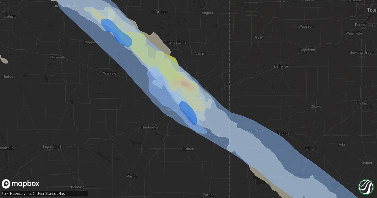
Hail Map in Fort Wayne, IN on June 13, 2022
Get this storm
June 13 map
$229
one time, instant access
Download today. No call, no setup
Keep the $229
Bought the map and want the full workflow? Apply the entire $229 to a subscription within 7 days. None of it is wasted.
Every map, not just this one
This buys you this map. Subscription and you get every map we run, in the markets you choose from a few cities to whole states to nationwide. Plus real-time alerts the moment a storm fires.
Contact data
Name, contact info, occupancy, even credit band for addresses in the footprint. You go from where it hit to who to call.
Become the source they trust
Unlimited branding weather history reports on demand. You already have the documented answer ready for the property owner, and you are the one who showed up with it.
Property data and RoofTrace estimates
Pull up any address you have got, its value and the exact code rules for that jurisdiction, straight from One Click Code. Then RoofTrace estimates the squares, pitch, and roof value, priced the way you price.
Storm reports in Fort Wayne, IN
Fort Wayne, IN
| Date | Description |
|---|---|
| 06/12/20229:48 PM CDT | Report from mping: quarter |
| 06/12/20229:48 PM CDT | Report from mping. |
| 06/12/20229:45 PM CDT | Asos station kfwa fort wayne international ap. |
| 06/12/20229:40 PM CDT | Healthy 2 foot diameter oak tree snapped off about 20 feet above the ground. |
| 06/12/20229:39 PM CDT | Multiple trees down on multiple houses... 2700 block of fairbrook court. |
| 06/12/20229:39 PM CDT | Significant structural damage to the skywest airlines building at fort wayne int. Ap. 98 mph wind gust reported at the airport. |
| 06/12/20229:39 PM CDT | Asos station kfwa fort wayne international ap. |
| 06/12/20229:39 PM CDT | Corrects time on previous tstm wnd gst report from 2 ene nine mile. Asos station kfwa fort wayne international ap. |
| 06/12/20229:39 PM CDT | 2 ft diameter tree snapped in half. Healthy tree. |
| 06/12/20229:35 PM CDT | Trained spotter reported estimated wind gusts around 80 mph and large trees broken in southwest fort wayne in allen county indiana. Power was also lost at the location. |
| 06/12/20229:35 PM CDT | Multiple trees snapped and down at the park center state street campus in fort wayne. Estimated to be around 6-12 inches in diameter. Time estimated from radar. |
| 06/12/20229:35 PM CDT | Numerous trees down or uprooted... Powerlines down... And roof damage to the willows of coventry apartments complex. Time estimated from radar. |
| 06/12/20229:30 PM CDT | Public reported that the local fire department had evacuated 10 structures |
| 06/12/20229:29 PM CDT | Multiple trees down. Dupont and coldwater. |
| 06/12/20229:28 PM CDT | Multiple power poles down in road. Aboite center rd near homestead hs. |
| 06/12/20229:26 PM CDT | A local report indicates 1.75 inch wind near 1 SW HUNTERTOWN |
| 06/12/20229:25 PM CDT | 2 foot tree onto house. Person trapped in the bella vista neighborhood. |
| 06/12/20229:20 PM CDT | Power lines knocked down along westbound illinois road... Near the intersection with scott road. Time estimated from radar. |
| 06/12/20229:18 PM CDT | Train blown off the tracks near bass road. Time estimated from radar. |
| 06/12/20229:15 PM CDT | Social media report of large estimated 24 inch diameter tree limb snapped off near rolling hills in allen county indiana. |
| 06/12/20229:12 PM CDT | Tree through house... Between us 30 and washington center... Near the allen/ whitley county line. |
| 06/12/20228:57 PM CDT | Report from mping: trees uprooted or snapped; roof blown off. |
All States Impacted by Hail Map on June 13, 2022
All Cities Impacted by Hail Map on June 13, 2022
- Fredonia, ND
- Kulm, ND
- Aneta, ND
- Killdeer, ND
- Rugby, ND
- Pingree, ND
- Saint Michael, ND
- Cresco, IA
- Lime Springs, IA
- Courtenay, ND
- Roseau, MN
- Goodrich, ND
- Lawler, IA
- West Concord, MN
- Custer, SD
- West Olive, MI
- Fairmont, MN
- Spring Grove, MN
- Manitowoc, WI
- New Hampton, IA
- Elma, IA
- Mauston, WI
- Lyndon Station, WI
- Cashton, WI
- Westby, WI
- Kendall, WI
- Elroy, WI
- Norwalk, WI
- Ontario, WI
- Wilton, WI
- Newcastle, WY
- Niles, MI
- Buchanan, MI
- Greenwood, IN
- Amherstdale, WV
- Rushville, IN
- Berlin, ND
- Lamoure, ND
- Augusta, ME
- Windsor, ME
- Flora, IN
- Michigantown, IN
- Frankfort, IN
- Forest, IN
- Walkerton, IN
- Findlay, OH
- Valley City, ND
- Fairfield, ND
- Denhoff, ND
- Drake, ND
- Mercer, ND
- Butte, ND
- Turtle Lake, ND
- Anamoose, ND
- Mcclusky, ND
- Martin, ND
- Washburn, ND
- Harvey, ND
- Maddock, ND
- Fingal, ND
- Marion, ND
- Sanborn, ND
- Rogers, ND
- Dickey, ND
- Litchville, ND
- Luverne, ND
- Dazey, ND
- Hannaford, ND
- Pine Ridge, SD
- Oriska, ND
- Tower City, ND
- Muskegon, MI
- Shawano, WI
- Leopolis, WI
- Marion, WI
- Wilton, ND
- Wall, SD
- York, ND
- Minnesota City, MN
- Clear Lake, IA
- Thornton, IA
- Reedsville, WI
- Manville, WY
- Faulkton, SD
- Bowdon, ND
- Robinson, ND
- Woodworth, ND
- Medina, ND
- Sheyenne, ND
- Cathay, ND
- Fessenden, ND
- Sykeston, ND
- Tappen, ND
- Oberon, ND
- Pettibone, ND
- New Rockford, ND
- Carrington, ND
- Badger, MN
- Greenbush, MN
- Ipswich, SD
- Mound City, SD
- Page, ND
- Sauk City, WI
- Prairie Du Sac, WI
- Sibley, IA
- Bigelow, MN
- Worthington, MN
- Ocheyedan, IA
- Rothbury, MI
- Charlotte, MI
- Ada, MI
- Sunfield, MI
- Mulliken, MI
- Nashville, MI
- Ionia, MI
- Lake Odessa, MI
- Freeport, MI
- Clarksville, MI
- Vermontville, MI
- Portland, MI
- Lowell, MI
- Saranac, MI
- Alto, MI
- Woodland, MI
- Roscoe, SD
- Linton, ND
- Kintyre, ND
- Napoleon, ND
- Finley, ND
- Bangor, WI
- Fort Pierre, SD
- Quincy, MI
- Macatawa, MI
- Holland, MI
- Roseglen, ND
- Montpelier, ND
- Hoven, SD
- Edinburg, ND
- Hope, ND
- Westport, SD
- Agar, SD
- Onida, SD
- Spiritwood, ND
- Wimbledon, ND
- Mountain Lake, MN
- Devils Lake, ND
- Faribault, MN
- Edgeley, ND
- Wishek, ND
- Streeter, ND
- Onalaska, WI
- Gackle, ND
- Buchanan, ND
- Cleveland, ND
- Jud, ND
- Jamestown, ND
- Kathryn, ND
- Nome, ND
- Prairie City, SD
- Mud Butte, SD
- Bison, SD
- Kents Hill, ME
- Mount Vernon, ME
- Readfield, ME
- Wayne, ME
- Ulen, MN
- Hawley, MN
- Hampden, ND
- Berkey, OH
- Swanton, OH
- Holland, OH
- Uhrichsville, OH
- Tippecanoe, OH
- Gnadenhutten, OH
- Port Washington, OH
- Jay Em, WY
- Lusk, WY
- Stryker, OH
- Bryan, OH
- West Unity, OH
- Alvin, IL
- Rossville, IL
- Emmitsburg, MD
- Osage, IA
- Rockford, IA
- Nora Springs, IA
- Orchard, IA
- Charles City, IA
- Rudd, IA
- Floyd, IA
- Vermillion, SD
- Marion, OH
- Morral, OH
- Wharton, OH
- Forest, OH
- Chesterville, OH
- Benton Ridge, OH
- Bucyrus, OH
- Rawson, OH
- Harpster, OH
- Fredericktown, OH
- Galion, OH
- McComb, OH
- Kirby, OH
- Cardington, OH
- Mount Blanchard, OH
- Jenera, OH
- Nevada, OH
- Caledonia, OH
- Leipsic, OH
- Arcadia, OH
- Arlington, OH
- Mount Cory, OH
- Upper Sandusky, OH
- Mount Gilead, OH
- Carey, OH
- Edison, OH
- Houston, MN
- West Lafayette, OH
- Newcomerstown, OH
- Coshocton, OH
- Kimbolton, OH
- Kyle, SD
- London, OH
- Elgin, MN
- Waterloo, OH
- Proctorville, OH
- Oak Hill, OH
- South Webster, OH
- Pedro, OH
- Wheelersburg, OH
- Scottown, OH
- Lesage, WV
- Patriot, OH
- Crown City, OH
- Willow Wood, OH
- Gallipolis, OH
- Kitts Hill, OH
- Lance Creek, WY
- Douglas, WY
- Conklin, MI
- Ravenna, MI
- Grant, MI
- Twin Lake, MI
- Holton, MI
- Fremont, MI
- Casnovia, MI
- Whitehall, MI
- Montague, MI
- Sabina, OH
- Murdo, SD
- White River, SD
- Wood, SD
- Draper, SD
- Bourbon, IN
- Etna Green, IN
- Goshen, OH
- Decatur, IN
- Minford, OH
- Lucasville, OH
- Beaver, OH
- Jackson, OH
- Morristown, MN
- Waterville, MN
- Wellington, IL
- Milford, IL
- Sod, WV
- Yawkey, WV
- Griffithsville, WV
- Fort Dodge, IA
- Badger, IA
- Claremont, MN
- Union Mills, IN
- Shawboro, NC
- Camden, NC
- Shiloh, NC
- Fayette, OH
- Alvordton, OH
- Whitehouse, OH
- Waterville, OH
- Grand Rapids, OH
- Bringhurst, IN
- Cutler, IN
- Coldwater, MI
- Grayson, KY
- Argillite, KY
- Greenup, KY
- Milford, OH
- Cincinnati, OH
- Camp Dennison, OH
- Lynchburg, OH
- Martinsville, OH
- New Vienna, OH
- Thorntown, IN
- Stewart, OH
- Guysville, OH
- Alkol, WV
- Dresden, OH
- Conesville, OH
- Adamsville, OH
- Dingess, WV
- Alexandria, OH
- Granville, OH
- Newark, OH
- Johnstown, OH
- Danville, IL
- Westville, IL
- Elizabethton, TN
- Hillsboro, IN
- Waynetown, IN
- Veedersburg, IN
- Covington, IN
- Pomeroy, OH
- Racine, OH
- Cheshire, OH
- Bidwell, OH
- Point Pleasant, WV
- West Chester, OH
- Indianapolis, IN
- New Marshfield, OH
- McArthur, OH
- Raysal, WV
- Paynesville, WV
- Iaeger, WV
- North Adams, MI
- Hillsdale, MI
- Hudson, MI
- Pittsford, MI
- Roan Mountain, TN
- Tazewell, VA
- Tannersville, VA
- Fortville, IN
- Ceres, VA
- Letart, WV
- Terrell, NC
- Sherrills Ford, NC
- Coinjock, NC
- Barco, NC
- Bronson, MI
- Lagrange, IN
- Pleasant Lake, IN
- Burr Oak, MI
- Fremont, IN
- Mark Center, OH
- Shipshewana, IN
- Hicksville, OH
- Sturgis, MI
- Hamilton, IN
- Orland, IN
- Howe, IN
- Edgerton, OH
- Montpelier, OH
- Butler, IN
- Edon, OH
- Angola, IN
- Saltville, VA
- Marion, VA
- Chilhowie, VA
- Gobles, MI
- Paw Paw, MI
- Kalamazoo, MI
- Mattawan, MI
- Amboy, MN
- Delavan, MN
- Good Thunder, MN
- Winnebago, MN
- Minnesota Lake, MN
- Mapleton, MN
- Waseca, MN
- Owatonna, MN
- Fairburn, SD
- Buffalo Gap, SD
- Tomah, WI
- Camp Douglas, WI
- Edgemont, SD
- Hot Springs, SD
- Spring Green, WI
- Lone Rock, WI
- Presho, SD
- Holabird, SD
- Pierre, SD
- Vivian, SD
- Harrold, SD
- Highmore, SD
- Blunt, SD
- Ellendale, ND
- Hosmer, SD
- Windom, MN
- Max, ND
- Fredericksburg, OH
- Sugarcreek, OH
- Millersburg, OH
- Wilmot, OH
- Dundee, OH
- Ligonier, IN
- Cromwell, IN
- Kimmell, IN
- Wooster, OH
- Philip, SD
- Quinn, SD
- Kadoka, SD
- Scenic, SD
- Leonidas, MI
- Mendon, MI
- Chatfield, OH
- New Washington, OH
- Shelby, OH
- Bloomville, OH
- Sycamore, OH
- Crestline, OH
- Tiro, OH
- Goshen, IN
- Van Wert, OH
- Ohio City, OH
- Wanblee, SD
- Interior, SD
- Leola, SD
- Piketon, OH
- Granada, MN
- Kirklin, IN
- Clendenin, WV
- Procious, WV
- Bomont, WV
- Lizemores, WV
- Glen, WV
- Indore, WV
- Annapolis, MD
- Wilmington, OH
- Shade, OH
- Coolville, OH
- Reedsville, OH
- Dillonvale, OH
- Cadiz, OH
- Adena, OH
- Williamstown, WV
- Mineral Wells, WV
- Saint Marys, WV
- Parkersburg, WV
- Reno, OH
- Marietta, OH
- Waverly, WV
- Walker, WV
- Vienna, WV
- Davisville, WV
- Martins Ferry, OH
- Bellaire, OH
- Wheeling, WV
- Bridgeport, OH
- Saint Clairsville, OH
- Connersville, IN
- New Paris, OH
- Richmond, IN
- Eaton, OH
- Glade Spring, VA
- Bandy, VA
- North Tazewell, VA
- Mountain Rest, SC
- Salem, SC
- Tamassee, SC
- Cashiers, NC
- Midland, SD
- Java, SD
- Eagle Butte, SD
- Selby, SD
- Gettysburg, SD
- Napoleon, OH
- Defiance, OH
- Holgate, OH
- Hamilton, OH
- Goodell, IA
- Kanawha, IA
- Britt, IA
- Garner, IA
- Lawrence, MI
- Kilkenny, MN
- Three Rivers, MI
- Centreville, MI
- Williams, IA
- Dows, IA
- Blairsburg, IA
- Bellevue, OH
- Jackson Center, OH
- Lewistown, OH
- Edwardsburg, MI
- Bristol, IN
- Anna, OH
- Larwill, IN
- Arcola, IN
- Monroe, IN
- Rome City, IN
- Minster, OH
- Venedocia, OH
- Rockford, OH
- Syracuse, IN
- New Paris, IN
- Monroeville, IN
- Russells Point, OH
- Osceola, IN
- South Bend, IN
- Willshire, OH
- Avilla, IN
- New Knoxville, OH
- Pierceton, IN
- Yoder, IN
- Topeka, IN
- Albion, IN
- Mishawaka, IN
- Hoagland, IN
- Millersburg, IN
- Notre Dame, IN
- New Carlisle, IN
- Quincy, OH
- Columbia City, IN
- Bellefontaine, OH
- Lakeview, OH
- Huntertown, IN
- Convoy, OH
- Granger, IN
- Mendon, OH
- Botkins, OH
- Wapakoneta, OH
- Fort Wayne, IN
- Kendallville, IN
- Wren, OH
- Churubusco, IN
- Ossian, IN
- Middlebury, IN
- Sidney, OH
- Elkhart, IN
- Galien, MI
- Wawaka, IN
- Saint Marys, OH
- Laotto, IN
- New Bremen, OH
- Celina, OH
- Maplewood, OH
- De Graff, OH
- Spencerville, OH
- New Haven, IN
- Willard, OH
- Republic, OH
- Wayne, OH
- Burgoon, OH
- Walhonding, OH
- Dunbridge, OH
- McCutchenville, OH
- Pemberville, OH
- Shiloh, OH
- Loudonville, OH
- Bellville, OH
- Lucas, OH
- Plymouth, OH
- Bloomdale, OH
- West Millgrove, OH
- Bascom, OH
- Clyde, OH
- Bettsville, OH
- Perrysville, OH
- Danville, OH
- Bradner, OH
- Fremont, OH
- Green Springs, OH
- Ashland, OH
- Warsaw, OH
- New Riegel, OH
- Mansfield, OH
- Haskins, OH
- Bowling Green, OH
- Fostoria, OH
- Luckey, OH
- Glenmont, OH
- Lindsey, OH
- Gibsonburg, OH
- Woodville, OH
- Butler, OH
- Monroeville, OH
- Tiffin, OH
- Old Fort, OH
- North Fairfield, OH
- Perrysburg, OH
- Helena, OH
- Brinkhaven, OH
- Portage, OH
- Attica, OH
- Risingsun, OH
- Alvada, OH
- Kansas, OH
- Killbuck, OH
- Peebles, OH
- Bainbridge, OH
- Waverly, OH
- Hillsboro, OH
- Latham, OH
- Bath, IN
- Brookville, IN
- Garrison, KY
- Sunbury, OH
- Marengo, OH
- Croton, OH
- Centerburg, OH
- Corning, OH
- Shawnee, OH
- New Lexington, OH
- Highlands, NC
- Minot, ND
- Sawyer, ND
- Douglas, ND
- Ryder, ND
- Garrison, ND
- Chesapeake, VA
- Virginia Beach, VA
- Butterfield, MN
- Grassy Butte, ND
- Hammond, IN
- Chesterton, IN
- Valparaiso, IN
- Hobart, IN
- Portage, IN
- Lake Station, IN
- East Chicago, IN
- Gary, IN
- Bensenville, IL
- Huntley, IL
- Belvidere, SD
- Okaton, SD
- Hayes, SD
- Long Valley, SD
- Porcupine, SD
- Ashley, OH
- Maineville, OH
- Franklin, OH
- Culver, IN
- Gilbert, WV
- Man, WV
- Camden, IN
- Whitestown, IN
- Lebanon, IN
- Norway, IA
- Atkins, IA
- Newhall, IA
- Amana, IA
- Harrison, OH
- Cleves, OH
- East Leroy, MI
- Climax, MI
- Ceresco, MI
- Battle Creek, MI
- Galesburg, MI
- Pittsboro, IN
- Lizton, IN
- Mount Vernon, OH
- Utica, OH
- Swiss, WV
- Dayton, OH
- New Lebanon, OH
- Brookville, OH
- Vinton, OH
- Scaly Mountain, NC
- Dillard, GA
- Otto, NC
- Rabun Gap, GA
- Plymouth, IN
- Argos, IN
- Wilkinson, IN
- Charlottesville, IN
- Greenfield, IN
- Moyock, NC
- Lore City, OH
- Freeport, OH
- Mccordsville, IN
- Henderson, WV
- Southside, WV
- Leon, WV
- Gallipolis Ferry, WV
- Dakota, MN
- Squire, WV
- Carmel, IN
- Knotts Island, NC
- Albany, OH
- Frederick, SD
- Hermosa, SD
- Mercersburg, PA
- Big Cove Tannery, PA
- Warfordsburg, PA
- Needmore, PA
- Blue Creek, OH
- Vandalia, MI
- South Haven, MI
- Jones, MI
- Dowagiac, MI
- Covert, MI
- Coloma, MI
- Hartford, MI
- Watervliet, MI
- Cassopolis, MI
- Marcellus, MI
- Decatur, MI
- Bangor, MI
- Genoa, WV
- Fort Gay, WV
- Fullerton, ND
- Mooresville, NC
- Honaker, VA
- Raven, VA
- Swords Creek, VA
- Damascus, VA
- Big Prairie, OH
- Shreve, OH
- Chicago, IL
- Wanatah, IN
- Whiting, IN
- Saint James, MN
- Dover, OH
- Bolivar, OH
- Strasburg, OH
- Manning, ND
- Mandaree, ND
- Vernon Center, MN
- Garden City, MN
- Madelia, MN
- Easton, MN
- Pemberton, MN
- Waldorf, MN
- Lewisville, MN
- Medford, MN
- Janesville, MN
- New Richland, MN
- Truman, MN
- Kenyon, MN
- Farmington, ME
- Wellsburg, WV
- Washington, PA
- Hickory, PA
- Avella, PA
- Brilliant, OH
- West Alexander, PA
- Claysville, PA
- Beech Bottom, WV
- Bethany, WV
- Rayland, OH
- Evans, WV
- Summersville, WV
- Glenwood, WV
- Benedict, ND
- Meadowview, VA
- Sapphire, NC
- Lake Toxaway, NC
- Milesville, SD
- New Underwood, SD
- Onaka, SD
- Tolstoy, SD
- Bowdle, SD
- Caputa, SD
- Hurdsfield, ND
- Vienna, ME
- New Sharon, ME
- Wonewoc, WI
- Hillsboro, WI
- Monon, IN
- Cedar Rapids, IA
- Fairfax, IA
- Long Bottom, OH
- Portland, OH
- Belleville, WV
- Ravenswood, WV
- Centreville, VA
- Clifton, VA
- Manassas, VA
- Bim, WV
- Clothier, WV
- Twilight, WV
- Lewisburg, OH
- West Alexandria, OH
- Lawrenceburg, IN
- Wayne, WV
- East Lynn, WV
- Hamler, OH
- Mount Victory, OH
- Millville, WV
- Purcellville, VA
- Harpers Ferry, WV
- Lovettsville, VA
- Greensburg, IN
- Laurel, IN
- Baltic, OH
- Fresno, OH
- Paulding, OH
- Walhalla, SC
- La Crescent, MN
- Forbes, ND
- Columbus Grove, OH
- Ashley, IN
- Dunkirk, OH
- Colon, MI
- Plainwell, MI
- Ottawa, OH
- Otsego, MI
- Ada, OH
- Alger, OH
- Fulton, MI
- Allegan, MI
- Athens, MI
- Deshler, OH
- Grand Junction, MI
- Corunna, IN
- Scotts, MI
- Saint Joe, IN
- Pandora, OH
- Sherwood, OH
- Ney, OH
- Pullman, MI
- Dola, OH
- Portage, MI
- Fennville, MI
- Vicksburg, MI
- Cecil, OH
- Malinta, OH
- Schoolcraft, MI
- Harrod, OH
- Bloomingdale, MI
- Kenton, OH
- Bluffton, OH
- Constantine, MI
- Waterloo, IN
- Sherwood, MI
- Hudson, IN
- White Pigeon, MI
- Oakwood, OH
- Union City, MI
- Huntington, IN
- Roanoke, IN
- Reading, MI
- Camden, MI
- Montgomery, MI
- Goodland, IN
- Kentland, IN
- Caldwell, OH
- Dexter City, OH
- Leesburg, OH
- Dickerson, MD
- Sparta, OH
- New Plymouth, OH
- Oakwood, VA
- Grundy, VA
- Hardy, VA
- Upton, WY
- Osage, WY
- Baroda, MI
- Vanlue, OH
- Verner, WV
- Heron Lake, MN
- Piedmont, OH
- Sparta, WI
- Ladoga, IN
- Delbarton, WV
- Matewan, WV
- Ironton, OH
- South Point, OH
- Hardy, IA
- Thor, IA
- Klemme, IA
- Goldfield, IA
- Renwick, IA
- Eagle Grove, IA
- Mount Perry, OH
- Somerset, OH
- Roseville, OH
- White Cottage, OH
- Zanesville, OH
- Washington, WV
- Riceville, IA
- Greenfield, OH
- Oronoco, MN
- Pine Island, MN
- Zumbro Falls, MN
- Rochester, MN
- Norwich, OH
- Nashport, OH
- Hopewell, OH
- Saint Louisville, OH
- Trinway, OH
- Frazeysburg, OH
- Heath, OH
- Friendship, WI
- Browntown, WI
- Monroe, WI
- Argyle, WI
- Pataskala, OH
- Valley Grove, WV
- Hamlet, IN
- West Lebanon, IN
- Williamsport, IN
- Monroe, OH
- Clarksville, OH
- Morrow, OH
- Lebanon, OH
- Middletown, OH
- Waynesville, OH
- Oregonia, OH
- South Lebanon, OH
- Blanchester, OH
- Liberty, IN
- Amigo, WV
- Mullens, WV
- Herndon, WV
- Itmann, WV
- Elizabeth City, NC
- Crooksville, OH
- Batavia, OH
- Mohawk, WV
- Panther, WV
- Eastover, SC
- Gadsden, SC
- Fulda, MN
- Westbrook, MN
- Newell, SD
- Holmesville, OH
- Blue Earth, MN
- Saugatuck, MI
- Collison, IL
- Potomac, IL
- Shelbyville, IN
- Manilla, IN
- Black Earth, WI
- Cross Plains, WI
- Mazomanie, WI
- Cottage Grove, WI
- Waterloo, WI
- Marshall, WI
- Windsor, WI
- Madison, WI
- Sun Prairie, WI
- Deerfield, WI
- Deforest, WI
- Quinwood, WV
- Sullivan, WI
- Oconomowoc, WI
- Helenville, WI
- Dousman, WI
- North Spring, WV
- Ikes Fork, WV
- Mcconnelsville, OH
- Lowell, OH
- Beverly, OH
- Hatton, ND
- Caledonia, MN
- Hokah, MN
- Litchfield, MI
- Allen, MI
- Jonesville, MI
- Osseo, MI
- Morenci, MI
- Jerome, MI
- Sullivan, OH
- Nova, OH
- Newport, KY
- Fort Thomas, KY
- Latonia, KY
- Hamersville, OH
- Ripley, OH
- Russellville, OH
- Georgetown, OH
- Covington, KY
- Melbourne, KY
- Amelia, OH
- New Richmond, OH
- Bethel, OH
- Silver Grove, KY
- Lyburn, WV
- Omar, WV
- Holden, WV
- Logan, WV
- Stollings, WV
- Switzer, WV
- West College Corner, IN
- Pleasant Plain, OH
- Cottageville, WV
- Ripley, WV
- Millwood, WV
- Rutland, OH
- Langsville, OH
- Logan, OH
- Madison, WV
- Milroy, IN
- Carpentersville, IL
- Palatine, IL
- Elmwood Park, IL
- Oak Park, IL
- Forest Park, IL
- Elmhurst, IL
- Arlington Heights, IL
- Des Plaines, IL
- Berwyn, IL
- River Forest, IL
- Cicero, IL
- Wood Dale, IL
- Mount Prospect, IL
- River Grove, IL
- Park Ridge, IL
- Schiller Park, IL
- Elk Grove Village, IL
- Barrington, IL
- Bellwood, IL
- Franklin Park, IL
- Prospect Heights, IL
- Rolling Meadows, IL
- Hoffman Estates, IL
- Melrose Park, IL
- Harwood Heights, IL
- Stone Park, IL
- Maywood, IL
- Schaumburg, IL
- Muskego, WI
- Franklin, WI
- Dane, WI
- Lake Mills, WI
- Hartland, WI
- Jefferson, WI
- Waunakee, WI
- Delafield, WI
- Ixonia, WI
- Wales, WI
- Brookfield, WI
- North Prairie, WI
- Cambridge, WI
- Watertown, WI
- South Milwaukee, WI
- Middleton, WI
- Fort Atkinson, WI
- Palmyra, WI
- Oak Creek, WI
- Waukesha, WI
- Cudahy, WI
- New Berlin, WI
- Hales Corners, WI
- Nashotah, WI
- Pewaukee, WI
- Big Bend, WI
- Mukwonago, WI
- Greendale, WI
- Johnson Creek, WI
- Milwaukee, WI
- Eagle, WI
- Morristown, IN
- Carthage, IN
- Arlington, IN
- Caledonia, WI
- Lodi, WI
- Elm Grove, WI
- Lawton, MI
- Okauchee, WI
- Columbus, WI
- Stoughton, WI
- Mcfarland, WI
- Saint Francis, WI
- Racine, WI
- Kent City, MI
- Sparta, MI
- Hartington, NE
- Fordyce, NE
- Sylvania, OH
- Toledo, OH
- Maumee, OH
- New Philadelphia, OH
- Mineral City, OH
- Apple Creek, OH
- Lakeville, OH
- Beach City, OH
- Storden, MN
- Jeffers, MN
- Bingham Lake, MN
- Prichard, WV
- Winona, MN
- Rushford, MN
- Lewiston, MN
- Shell Rock, IA
- Roselle, IL
- Itasca, IL
- Gilberts, IL
- Berkeley, IL
- Riverside, IL
- Broadview, IL
- Wheeling, IL
- Glenview, IL
- Fox River Grove, IL
- Lake In The Hills, IL
- Lincolnwood, IL
- Hanover Park, IL
- Westchester, IL
- Algonquin, IL
- Dundee, IL
- Elgin, IL
- Hanna, IN
- Hines, IL
- Addison, IL
- La Crosse, IN
- Niles, IL
- Streamwood, IL
- Medinah, IL
- Hillside, IL
- Tekonsha, MI
- Enderlin, ND
- Cozad, NE
- Jeromesville, OH
- Glenwood, IN
- Leeds, ME
- Gwynneville, IN
- Fountaintown, IN
- Miamisburg, OH
- Germantown, OH
- Knox, IN
- Grovertown, IN
- Danville, WV
- Cumberland, OH
- Chandlersville, OH
- Stockport, OH
- Coal Run, OH
- Macksburg, OH
- Blue Rock, OH
- Waterford, OH
- Emmalena, KY
- Hazard, KY
- Ary, KY
- Continental, OH
- New Bavaria, OH
- Middleport, OH
- West Columbia, WV
- Mason, WV
- Wilkesville, OH
- Cyclone, WV
- Clear Fork, WV
- Simon, WV
- Coal Mountain, WV
- Davin, WV
- Milton, WV
- Branchland, WV
- Hurricane, WV
- Salt Rock, WV
- Chesapeake, OH
- Ona, WV
- Huntington, WV
- West Hamlin, WV
- Hamlin, WV
- Barboursville, WV
- Culloden, WV
- South Charleston, WV
- Elkview, WV
- Tad, WV
- Dunbar, WV
- Charleston, WV
- Concord, NC
- Huntersville, NC
- Davidson, NC
- Phelps, KY
- Hurley, VA
- Stopover, KY
- North Monmouth, ME
- Plain, WI
- Gotham, WI
- Winthrop, ME
- Hoopeston, IL
- Henning, IL
- La Rue, OH
- Ridgeway, OH
- Wallback, WV
- Maysel, WV
- Clay, WV
- Wharncliffe, WV
- Dennison, OH
- Tuscarawas, OH
- Mason City, IA
- Polk, OH
- West Salem, OH
- Shepherdstown, WV
- Sharpsburg, MD
- Oakes, ND
- Eureka, SD
- Aberdeen, SD
- Oral, SD
- Callaway, NE
- Liberty Center, OH
- Hewett, WV
- Turtle Creek, WV
- Pioneer, OH
- Philo, OH
- Russell, KY
- Flatwoods, KY
- Oxford, OH
- Trenton, OH
- Johnson City, TN
- Yolyn, WV
- Goodview, VA
- Vassalboro, ME
- Belgrade, ME
- Ellendale, MN
- Mindoro, WI
- Trempealeau, WI
- Holmen, WI
- La Crosse, WI
- West Salem, WI
- Greenwich, OH
- Stone Creek, OH
- Nelsonville, OH
- Great Falls, VA
- Poolesville, MD
- Sterling, VA
- Stout, OH
- Vanceburg, KY
- Berwind, WV
- Pounding Mill, VA
- Cedar Bluff, VA
- Richlands, VA
- Springer, OK
- Morton Grove, IL
- Fort Totten, ND
- Crary, ND
- Warwick, ND
- Verona, ND
- Middle River, MN
- Thief River Falls, MN
- Inkster, ND
- Dahlen, ND
- Grafton, ND
- Saint Thomas, ND
- Strandquist, MN
- Fisher, MN
- Viking, MN
- Stephen, MN
- Hoople, ND
- Saint Vincent, MN
- Portland, ND
- Gilby, ND
- Mayville, ND
- Lancaster, MN
- Binford, ND
- Warren, MN
- Pisek, ND
- Forest River, ND
- Alvarado, MN
- Clifford, ND
- Kennedy, MN
- Grygla, MN
- Karlstad, MN
- Pembina, ND
- Lisbon, ND
- Goodridge, MN
- Fort Ransom, ND
- Buffalo, ND
- Grand Forks, ND
- Bathgate, ND
- Donaldson, MN
- Mcville, ND
- Reynolds, ND
- Oslo, MN
- Lakota, ND
- Gatzke, MN
- Thompson, ND
- Lake Bronson, MN
- Mchenry, ND
- Arvilla, ND
- Wannaska, MN
- Sharon, ND
- Drayton, ND
- Strathcona, MN
- Michigan, ND
- Niagara, ND
- Park River, ND
- Argyle, MN
- Manvel, ND
- Fordville, ND
- Crystal, ND
- East Grand Forks, MN
- Jessie, ND
- Mekinock, ND
- Larimore, ND
- Ypsilanti, ND
- Glasston, ND
- Grand Forks Afb, ND
- Cooperstown, ND
- Halma, MN
- Pekin, ND
- Pillsbury, ND
- Newfolden, MN
- Humboldt, MN
- Petersburg, ND
- Hamilton, ND
- Northwood, ND
- Minto, ND
- Sutton, ND
- Lankin, ND
- Emerado, ND
- Gwinner, ND
- Hallock, MN
- Viborg, SD
- Gayville, SD
- Centerville, SD
- Beresford, SD
- Irene, SD
- Saint Helena, NE
- Wakonda, SD
- Worthing, SD
- Yankton, SD
- Canton, SD
- Lennox, SD
- Volin, SD
- Davis, SD
- Mission Hill, SD
- Corwith, IA
- Harrison, NE
- Sandyville, WV
- South Elgin, IL
- Bartlett, IL
- Bloomingdale, IL
- Lyons, IL
- La Grange, IL
- Skokie, IL
- Summit Argo, IL
- Burbank, IL
- Brookfield, IL
- La Grange Park, IL
- Verona, WI
- Archbold, OH
- Wauseon, OH
- Hoytville, OH
- Van Buren, OH
- Waldron, MI
- North Baltimore, OH
- Wolcottville, IN
- Miller City, OH
- Custar, OH
- Ridgeville Corners, OH
- Cygnet, OH
- Williamstown, OH
- Evansport, OH
- Buckland, OH
- Pemberton, OH
- Belle Center, OH
- West Liberty, OH
- Saint Paris, OH
- Nappanee, IN
- New Hampshire, OH
- Rosewood, OH
- Uniopolis, OH
- Wakarusa, IN
- Milford, IN
- North Webster, IN
- Marysville, OH
- Huntsville, OH
- Zanesfield, OH
- Lima, OH
- Leesburg, IN
- Middle Point, OH
- Woodstock, OH
- Mechanicsburg, OH
- Mingo, OH
- Port Jefferson, OH
- Waynesfield, OH
- Milford Center, OH
- North Lewisburg, OH
- Conover, OH
- East Liberty, OH
- Urbana, OH
- Warsaw, IN
- Rushsylvania, OH
- Delphos, OH
- Cable, OH
- Hopedale, OH
- Scio, OH
- Jewett, OH
- Bloomingdale, OH
- Flushing, OH
- Smithfield, OH
- Bowerston, OH
- Artie, WV
- Alderson, WV
- Lerona, WV
- Tornado, WV
- Red House, WV
- Frankfort, OH
- New Richmond, WV
- Mount Carbon, WV
- Dorothy, WV
- Ashland, KY
- Pond Gap, WV
- Brenton, WV
- Catlettsburg, KY
- Athens, WV
- Nettie, WV
- Washington Court House, OH
- Londonderry, OH
- Maben, WV
- Matheny, WV
- Canvas, WV
- Colcord, WV
- Blount, WV
- Fayetteville, WV
- Crab Orchard, WV
- Victor, WV
- Rainelle, WV
- East Bank, WV
- Racine, WV
- Glen White, WV
- Meadow Bridge, WV
- Jumping Branch, WV
- Oceana, WV
- Whitesville, WV
- Layland, WV
- Powellton, WV
- Mount Nebo, WV
- Pence Springs, WV
- Camp Creek, WV
- Orgas, WV
- Handley, WV
- Winfield, WV
- Arnett, WV
- Nellis, WV
- Portsmouth, OH
- Costa, WV
- Princewick, WV
- Pool, WV
- Montgomery, WV
- McDermott, OH
- Miami, WV
- Fenwick, WV
- Hico, WV
- Otway, OH
- Glen Fork, WV
- Hansford, WV
- Ghent, WV
- South Salem, OH
- Belva, WV
- Asbury, WV
- Ravencliff, WV
- Crawley, WV
- Saint Albans, WV
- Saulsville, WV
- Ashford, WV
- Rhodell, WV
- Nitro, WV
- Seth, WV
- Beckley, WV
- Clear Creek, WV
- Pineville, WV
- Pratt, WV
- Lavalette, WV
- Jesse, WV
- Friendship, OH
- Glen Daniel, WV
- Green Sulphur Springs, WV
- Laurelville, OH
- Fairdale, WV
- Drennen, WV
- Beaver, WV
- Ansted, WV
- Richmond Dale, OH
- Scarbro, WV
- South Shore, KY
- Saxon, WV
- Spanishburg, WV
- Rock, WV
- Rupert, WV
- Surveyor, WV
- Stephenson, WV
- Meadow Creek, WV
- Cedar Grove, WV
- Drybranch, WV
- Poca, WV
- Worthington, KY
- Shady Spring, WV
- Kincaid, WV
- Rock Creek, WV
- Thurmond, WV
- Odd, WV
- Bolt, WV
- London, WV
- Wellston, OH
- Sophia, WV
- Coalton, OH
- Rush, KY
- Pipestem, WV
- Midway, WV
- Princeton, WV
- Given, WV
- Talcott, WV
- Grassy Meadows, WV
- South Bloomingville, OH
- Kenna, WV
- Naoma, WV
- Cool Ridge, WV
- Ceredo, WV
- Danese, WV
- Lookout, WV
- Williamsport, OH
- Circleville, OH
- Scott Depot, WV
- Mount Hope, WV
- Wharton, WV
- Gallagher, WV
- Eskdale, WV
- Glasgow, WV
- Rio Grande, OH
- Lashmeet, WV
- Daniels, WV
- Sylvester, WV
- Cabin Creek, WV
- Glen Jean, WV
- Winifrede, WV
- Hinton, WV
- Liberty, WV
- Spring Dale, WV
- Coal City, WV
- Mount Lookout, WV
- Belle, WV
- Rarden, OH
- Thurman, OH
- Nimitz, WV
- Apple Grove, WV
- Lester, WV
- Peytona, WV
- Quincy, KY
- Buffalo, WV
- Bloomingrose, WV
- Oak Hill, WV
- Matoaka, WV
- Mount Sterling, OH
- Dixie, WV
- Eleanor, WV
- Gauley Bridge, WV
- Hernshaw, WV
- Foster, WV
- Comfort, WV
- Ray, OH
- Nallen, WV
- Ashton, WV
- Charmco, WV
- New Holland, OH
- Beeson, WV
- Ridgeview, WV
- Lansing, WV
- Leivasy, WV
- Kanawha Falls, WV
- Wyoming, WV
- Smithers, WV
- South Portsmouth, KY
- Kingston, OH
- Chillicothe, OH
- Fraziers Bottom, WV
- Sumerco, WV
- Hugheston, WV
- West Portsmouth, OH
- Clarksburg, OH
- Smoot, WV
- Richwood, WV
- Sandstone, WV
- Glen Rogers, WV
- Kenova, WV
- Flat Top, WV
- Edmond, WV
- Kimberly, WV
- Robson, WV
- White Oak, WV
- Alum Creek, WV
- Dry Creek, WV
- Slab Fork, WV
- Mammoth, WV
- Franklin Furnace, OH
- Josephine, WV
- Hamden, OH
- Greens Fork, IN
- College Corner, OH
- Camden, OH
- Kings Mills, OH
- Seven Mile, OH
- Brownsville, IN
- Xenia, OH
- Cambridge City, IN
- Milton, IN
- Harveysburg, OH
- Springboro, OH
- New Castle, IN
- Clayton, OH
- Spring Valley, OH
- Farmersville, OH
- Boston, IN
- Centerville, IN
- Straughn, IN
- Hagerstown, IN
- Mason, OH
- Bellbrook, OH
- Somerville, OH
- Gambier, OH
- Martinsburg, OH
- Howard, OH


