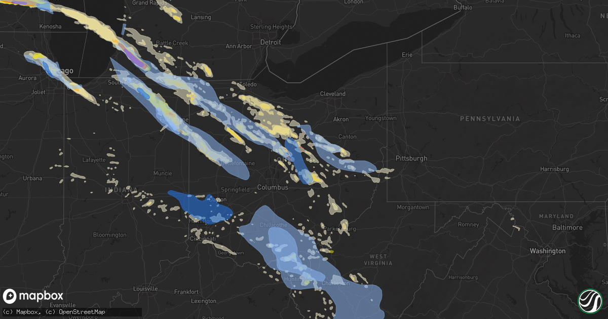
Hail Map in Ohio on June 13, 2022
Get this storm
June 13 map
$229
one time, instant access
Download today. No call, no setup
Keep the $229
Bought the map and want the full workflow? Apply the entire $229 to a subscription within 7 days. None of it is wasted.
Every map, not just this one
This buys you this map. Subscription and you get every map we run, in the markets you choose from a few cities to whole states to nationwide. Plus real-time alerts the moment a storm fires.
Contact data
Name, contact info, occupancy, even credit band for addresses in the footprint. You go from where it hit to who to call.
Become the source they trust
Unlimited branding weather history reports on demand. You already have the documented answer ready for the property owner, and you are the one who showed up with it.
Property data and RoofTrace estimates
Pull up any address you have got, its value and the exact code rules for that jurisdiction, straight from One Click Code. Then RoofTrace estimates the squares, pitch, and roof value, priced the way you price.
Storm reports in Ohio
Ohio
| Date | Description |
|---|---|
| 06/13/20226:47 PM CDT | A few trees down in the area. Time estimated. |
| 06/13/20226:32 PM CDT | Trees down. Time estimated from radar. |
| 06/13/20226:27 PM CDT | Trees down throughout the city. Time estimated from radar. |
| 06/13/20226:27 PM CDT | Trees down througout the city. Time estimated from radar. |
| 06/13/20226:24 PM CDT | Numerous large branches down and a tree snapped. Time est from radar. |
| 06/13/20226:20 PM CDT | Roof ripped off a trailer. Time estimated from radar. |
| 06/13/20226:15 PM CDT | Semi-truck knocked onto its side on us 28 near morgan rd |
| 06/13/20226:11 PM CDT | Trees down across the city. Time estimated from radar. |
| 06/13/20226:11 PM CDT | Metal from a building removed and damaged a car. Trees also down in the city. Time estimated. |
| 06/13/20226:11 PM CDT | Metal from a building removed and damaged a car. Trees also down in the city. Roof of 3rd floor apartment building removed. Local media reports two were transferred to hospit |
| 06/13/20226:10 PM CDT | Trailer home pushed off its foundation. Garage damaged. |
| 06/13/20226:03 PM CDT | Trees down throughout the city. Time estimated from radar. |
| 06/13/20226:03 PM CDT | Trees down.time estimated from radar. |
| 06/13/20226:01 PM CDT | Trees snapped/ down in road |
| 06/13/20226:01 PM CDT | Tree fell into house on poplar street. |
| 06/13/20225:59 PM CDT | Lots of wind damage along us 50 and north beach rd between hillsboro and cynthiana in highland county. Reports of many trees and power lines downed. Time estimated from |
| 06/13/20225:57 PM CDT | Trees down. Time estimated from radar. |
| 06/13/20225:50 PM CDT | Trees down all along 9th street. |
| 06/13/20225:40 PM CDT | Trees down across the city. Time estimated from radar. |
| 06/13/20225:31 PM CDT | Trees down in the city. Time estimated from radar. |
| 06/13/20225:31 PM CDT | Trees down across the city. Time estimated from radar. |
| 06/13/20225:21 PM CDT | Large 8-10 inch diameter tree limbs down |
| 06/13/20225:20 PM CDT | Large tree limbs down and trees snapped |
| 06/13/20225:20 PM CDT | Large trees down |
| 06/13/20225:18 PM CDT | Large limbs down. Time estimated from radar. |
| 06/13/20225:16 PM CDT | Large healthy tree downed on property. Time estimated. |
| 06/13/20225:16 PM CDT | Large healthy tree downed on property. |
| 06/13/20225:16 PM CDT | Large tree uprooted |
| 06/13/20225:15 PM CDT | 2 ft diameter spruce tree down. Time estimate from radar. |
| 06/13/20225:15 PM CDT | Trees down on xenia drive. Time estimated from radar. |
| 06/13/20225:13 PM CDT | 1 ft diameter tree down. Time estimated from radar. |
| 06/13/20225:11 PM CDT | Trees and large limbs down. Time estimated from radar. |
| 06/13/20225:11 PM CDT | Large... Healthy tree downed across galley hill rd. Time estimated from radar. |
| 06/13/20225:11 PM CDT | Large trees down near fields ertel rd and mccauly rd |
| 06/13/20225:09 PM CDT | Tree and large limbs down. Time estimated from radar. |
| 06/13/20225:06 PM CDT | Large tree in road. Time from radar |
| 06/13/20225:04 PM CDT | A local report indicates 60 MPH wind near KI68 LEBANON APT |
| 06/13/20225:04 PM CDT | Large trees down- car damage from trees falling on cars. Time from radar. |
| 06/13/20225:04 PM CDT | Spotter reports multiple 2+ inch limbs down- car damage from limbs falling. |
| 06/13/20225:02 PM CDT | 12 inch healthy limb down. Time estimated from radar. |
| 06/13/20225:02 PM CDT | Tree fell on car at villanova and kenosha. Time estimated from radar. |
| 06/13/20224:59 PM CDT | Several trees 10-12 inches in diameter down. Time est. From radar. |
| 06/13/20224:59 PM CDT | Large mature tree fell on house near oberlin and holiday drives. Time estimated from radar. |
| 06/13/20224:59 PM CDT | Large tree... 13-14 inch diameter... Down |
| 06/13/20224:58 PM CDT | Hardwood trees 2-3ft in diameter down. Time from radar |
| 06/13/20224:57 PM CDT | Large tree blocking southbound lane of lamme road. Time estimated from radar. |
| 06/13/20224:56 PM CDT | Tree limbs down 2+ inches in diameter. Time from radar |
| 06/13/20224:56 PM CDT | Large 12-13 inch tree limbs downed. Time from radar |
| 06/13/20224:56 PM CDT | Large 12-13 inch tree limbs downed. Time from radar |
| 06/13/20224:56 PM CDT | Multiple large...healthy trees down on fenwick ct... Including one on a house and one on a car. Time estimated from radar. |
| 06/13/20224:55 PM CDT | Large trees snapped. Time from radar |
| 06/13/20224:55 PM CDT | Large tree uprooted |
| 06/13/20224:55 PM CDT | Large tree fell on car on rollins drive. |
| 06/13/20224:53 PM CDT | Large... Healthy tree down on socialville-fosters rd. Time estimated from radar. |
| 06/13/20224:53 PM CDT | Large tree limb down. Time from radar |
| 06/13/20224:50 PM CDT | Trees down all along 9th street. |
| 06/13/20224:50 PM CDT | Branches down on cars and on banning road. |
| 06/13/20224:48 PM CDT | Large... Healthy tree down on butler-warren rd... About 12-15 inches in diameter. Time estimated from radar. |
| 06/13/20224:48 PM CDT | Limb 2+ foot in diameter down. |
| 06/13/20224:48 PM CDT | Eight large trees down. |
| 06/13/20224:47 PM CDT | Large tree blocking cincinnati-dayton road. Time estimated from radar. |
| 06/13/20224:45 PM CDT | Mesonet station ew6002 hamilton. |
| 06/13/20224:45 PM CDT | 6-12 inch branches down. |
| 06/13/20224:41 PM CDT | From personal weather station at preble county ema office |
| 06/13/20224:30 PM CDT | Large tree down on eaton gettysburg road. Time estimated from radar. |
| 06/13/20224:30 PM CDT | 1/4 mile swath of 1 inch limbs down. Time from radar |
| 06/13/20224:28 PM CDT | Quarter sized/ 1 inch hail |
| 06/13/20226:49 AM CDT | At 1149 PM EDT, a severe thunderstorm was located near Jackson Center, moving southeast at 45 mph. HAZARD...70 mph wind gusts and penny size hail. SOURCE...Radar indicated. IMPACT...Expect considerable tree damage. Damage is likely to mobile homes, roofs, and outbuildings. Locations impacted include... Marysville, Sidney, Bellefontaine, Urbana, Kenton, Richwood, St. Paris, Newport, West Liberty, Mechanicsburg, North Lewisburg, De Graff, West Mansfield, Hardin, Northwood, Milford Center, Quincy, Mount Victory, Rushsylvania and Ridgeway.This includes I-75 in Ohio between mile markers 85 and 93. |
| 06/13/20226:43 AM CDT | At 1143 PM EDT, severe thunderstorms were located along a line extending from Lodi to 6 miles south of Loudonville to near Johnstown, moving southeast at 50 mph. HAZARD...70 mph wind gusts and nickel size hail. SOURCE...Radar indicated. IMPACT...Trees snapped and uprooted. Power outages can be expected. Locations impacted include... Zanesville, New Philadelphia, Dover, Coshocton, Cambridge, Uhrichsville, Newcomerstown, Minerva, Dennison, Strasburg, New Concord, and Byesville. |
| 06/13/20226:34 AM CDT | At 1134 PM EDT, severe thunderstorms were located along a line extending from 6 miles southeast of Wellington to near Polk to near Mansfield, moving southeast at 45 mph. HAZARD...70 mph wind gusts and penny size hail. SOURCE...Radar indicated. IMPACT...Expect considerable tree damage. Damage is likely to mobile homes, roofs, and outbuildings. Locations impacted include... Canton, Wooster, Millersburg, Massillon, Green, Wadsworth, North Canton, Orrville, Berlin, Rittman, Walnut Creek, Doylestown, Loudonville, Creston, Brewster, Navarre, Dalton, Shreve, Waynesburg and East Sparta. |
| 06/13/20226:31 AM CDT | At 1131 PM EDT, a severe thunderstorm was located over Centerburg, moving southeast at 60 mph. HAZARD...70 mph wind gusts and penny size hail. SOURCE...Radar indicated. IMPACT...Expect considerable tree damage. Damage is likely to mobile homes, roofs, and outbuildings. Locations impacted include... Columbus, Newark, Dublin, Westerville, Reynoldsburg, Upper Arlington, Gahanna, Hilliard, Worthington, Bexley, Heath, Granville, Pataskala, Johnstown, Buckeye Lake, Hebron, Utica, Minerva Park, Hanover and Marne.This includes the following Interstates... I-70 in Ohio near mile marker 111, and between mile markers 114 and142, and near mile marker 144. I-71 in Ohio between mile markers 112 and 121. |
| 06/13/20226:22 AM CDT | At 1122 PM EDT, a severe thunderstorm was located near Spencerville, moving southeast at 40 mph. HAZARD...70 mph wind gusts and penny size hail. SOURCE...Radar indicated. IMPACT...Expect considerable tree damage. Damage is likely to mobile homes, roofs, and outbuildings. Locations impacted include... Sidney, Bellefontaine, Wapakoneta, Fort Shawnee, New Bremen, Minster, Newport, Cridersville, Anna, Fort Loramie, Jackson Center, Russells Point, De Graff, Botkins, Lakeview, New Knoxville, Alger, Waynesfield, Belle Center and Chippewa Park.This includes I-75 in Ohio between mile markers 92 and 118. |
| 06/13/20226:19 AM CDT | At 1119 PM EDT, severe thunderstorms were located along a line extending from near Delphos to 6 miles west of Spencerville, moving southeast at 60 mph. THESE ARE DESTRUCTIVE STORMS! HAZARD...80 mph wind gusts. SOURCE...Radar indicated. IMPACT...Flying debris will be dangerous to those caught without shelter. Mobile homes will be heavily damaged. Expect considerable damage to roofs, windows, and vehicles. Extensive tree damage and power outages are likely. Locations impacted include... Lima, Fort Shawnee, Spencerville, Elida, Spencerville In Allen County, Cairo, Harrod, Beaverdam, Vaughnsville, Yoder, Conant, Westminster, Hume, Slabtown, Rushmore, Gomer, Rousculp, Southworth, Needmore and Rimer.This includes Interstate 75 between mile markers 119 and 136. |
| 06/13/20226:12 AM CDT | At 1111 PM EDT, severe thunderstorms were located along a line extending from Crestline to 7 miles northwest of Mount Gilead to near Marion, moving southeast at 75 mph. HAZARD...70 mph wind gusts and quarter size hail. SOURCE...Radar indicated. IMPACT...Minor damage to vehicles is possible. Expect considerable tree damage. Wind damage is also likely to mobile homes, roofs, and outbuildings. Locations impacted include... Mansfield, Ashland, Mount Vernon, Mount Gilead, Ontario, Lexington, Crestline, Loudonville, Fredericktown, Gambier, Cardington, Bellville, Centerburg, Ashley, Danville, Hayesville, Chesterville, Sparta, Waterford and Butler. |
| 06/13/20226:12 AM CDT | At 1111 PM EDT, a severe thunderstorm was located near Prospect, moving southeast at 50 mph. HAZARD...70 mph wind gusts and penny size hail. SOURCE...Radar indicated. IMPACT...Expect considerable tree damage. Damage is likely to mobile homes, roofs, and outbuildings. Locations impacted include... Dublin, Westerville, Delaware, Kenton, Powell, Sunbury, Richwood, Ashley, Polaris, Radnor, Shawnee Hills, Galena, Ostrander, Mount Victory, Ridgeway, Magnetic Springs, Alum Creek State Park, Delaware State Park, Olive Green and Pfeiffer.This includes I-71 in Ohio between mile markers 122 and 138. |
| 06/13/20226:04 AM CDT | At 1104 PM EDT, a severe thunderstorm was located over Convoy, or near Van Wert, moving southeast at 35 mph. THIS IS A DESTRUCTIVE STORM!. HAZARD...80 mph wind gusts. SOURCE...Radar indicated. IMPACT...Flying debris will be dangerous to those caught without shelter. Mobile homes will be heavily damaged. Expect considerable damage to roofs, windows, and vehicles. Extensive tree damage and power outages are likely. Locations impacted include... Van Wert, Delphos, Convoy, Ottoville, Ohio City, Middlebury, Middle Point, Fort Jennings, Scott, Venedocia, Elgin, Wetzel, Tipton, Cavett, Dull and Jonestown. |
| 06/13/20226:01 AM CDT | At 1100 PM EDT, severe thunderstorms were located along a line extending from near Wakeman to 7 miles west of New London to near Willard, moving southeast at 55 mph. HAZARD...60 mph wind gusts and penny size hail. SOURCE...Trained weather spotters. IMPACT...Expect damage to trees and power lines. Locations impacted include... Mansfield, Ashland, Shelby, Grafton, Willard, Wellington, Lodi, New London, Plymouth, West Salem, Wakeman, Savannah, Polk, Oberlin, Sullivan, Lagrange, Penfield, South Amherst, Pittsfield and Greenwich. |
| 06/13/20226:01 AM CDT | At 1100 PM EDT, a severe thunderstorm was located over Convoy, or 8 miles northwest of Van Wert, moving southeast at 35 mph. THIS IS A DESTRUCTIVE STORM!. HAZARD...80 mph wind gusts. SOURCE...Radar indicated. IMPACT...Flying debris will be dangerous to those caught without shelter. Mobile homes will be heavily damaged. Expect considerable damage to roofs, windows, and vehicles. Extensive tree damage and power outages are likely. Locations impacted include... Van Wert, Delphos, Convoy, Ottoville, Middle Point, Fort Jennings, Scott, Venedocia, Elgin, Wetzel, Tipton, Cavett and Jonestown. |
| 06/13/20225:53 AM CDT | At 1052 PM EDT, severe thunderstorms were located along a line extending from near Chatfield to near Marseilles, moving southeast at 65 mph. HAZARD...70 mph wind gusts and quarter size hail. SOURCE...Radar indicated. IMPACT...Minor damage to vehicles is possible. Expect considerable tree damage. Wind damage is also likely to mobile homes, roofs, and outbuildings. Locations impacted include... Marion, Bucyrus, Galion, Crestline, Prospect, New Washington, La Rue, Morral, Waldo, Chatfield, Marseilles, Benton, Nevada, Caledonia, New Bloomington, Green Camp, Tiro, North Robinson, Harpster and Oceola. |
| 06/13/20225:47 AM CDT | At 1047 PM EDT, a severe thunderstorm was located near Ossian, moving southeast at 40 mph. HAZARD...70 mph wind gusts and penny size hail. SOURCE...Radar indicated. IMPACT...Expect considerable tree damage. Damage is likely to mobile homes, roofs, and outbuildings. Locations impacted include... Celina, Wapakoneta, St. Marys, Coldwater, New Bremen, Minster, St. Henry, Fort Recovery, Rockford, New Knoxville, Moulton, Wabash, Mendon, Chickasaw, Burkettsville, Buckland, Montezuma, Tama, Egypt and Maria Stein. |
| 06/13/20225:27 AM CDT | At 1026 PM EDT, severe thunderstorms were located along a line extending from near Fort Wayne to 7 miles north of Ossian to 6 miles north of Markle, moving southeast at 55 mph. THESE ARE DESTRUCTIVE STORMS! HAZARD...80 mph wind gusts. SOURCE...Radar indicated. IMPACT...Flying debris will be dangerous to those caught without shelter. Mobile homes will be heavily damaged. Expect considerable damage to roofs, windows, and vehicles. Extensive tree damage and power outages are likely. Locations impacted include... Fort Wayne, New Haven, Bluffton, Decatur, Berne, Ossian, Geneva, Monroeville, Markle, Monroe, Middletown, Roanoke, Middlebury, Preble, Nottingham, Zanesville, Willshire, Uniondale, Wren and Poneto.This includes the following highways... Interstate 469 between mile markers 0 and 18. Interstate 69 in Indiana between mile markers 286 and 311. |
| 06/13/20225:19 AM CDT | At 1019 PM EDT, a severe thunderstorm was located near McComb, or 11 miles northwest of Findlay, moving southeast at 60 mph. HAZARD...70 mph wind gusts and quarter size hail. SOURCE...Radar indicated. IMPACT...Minor damage to vehicles is possible. Expect considerable tree damage. Wind damage is also likely to mobile homes, roofs, and outbuildings. Locations impacted include... Findlay, Tiffin, Fostoria, Upper Sandusky, Bluffton, North Baltimore, McComb, Forest, Arlington, Bloomville, Sycamore, Arcadia, Rawson, Vanlue, Van Buren, New Riegel, Carey, Attica, Nevada and Bloomdale. |
| 06/13/20225:16 AM CDT | At 1016 PM EDT, severe thunderstorms were located along a line extending from near Elmore to 6 miles south of Gibsonburg to near North Baltimore, moving southeast at 40 mph. HAZARD...60 mph wind gusts and penny size hail. SOURCE...Radar indicated. IMPACT...Expect damage to trees and power lines. Locations impacted include... Sandusky, Tiffin, Norwalk, Fremont, Fostoria, Port Clinton, Bellevue, Clyde, Oak Harbor, Green Springs, Northern Milan, Milan, Castalia, Ballville, Monroeville, Marblehead, Attica, Bettsville, Bay View and Risingsun. |
| 06/13/20224:55 AM CDT | At 954 PM EDT, a severe thunderstorm was located over Coalton, or near Cannonsburg, moving southeast at 50 mph. HAZARD...60 mph wind gusts and penny size hail. SOURCE...Radar indicated. IMPACT...Expect damage to roofs, siding, and trees. Locations impacted include... Huntington, Ashland, Grayson, Louisa, Coal Grove, Wayne, Chesapeake, Beech Fork State Park, Cannonsburg, Yatesville Lake State Park, Kenova, Catlettsburg, Ceredo, Fort Gay, Princess, Coalton, Denton, Burnaugh, Gesling and Oldtown.This includes the following highways... Interstate 64 in Kentucky between mile markers 168 and 191. Interstate 64 in West Virginia between mile markers 1 and 14. |
| 06/13/20224:55 AM CDT | At 954 PM EDT, a severe thunderstorm was located near Defiance, moving southeast at 70 mph. HAZARD...70 mph wind gusts and quarter size hail. SOURCE...Radar indicated. IMPACT...Hail damage to vehicles is expected. Expect considerable tree damage. Wind damage is also likely to mobile homes, roofs, and outbuildings. Locations impacted include... Defiance, Ottawa, Leipsic, Kalida, Pandora, Continental, Glandorf, Oakwood, Dupont, Melrose, West Leipsic, Cecil, Gilboa, Cloverdale, Belmore, Miller City, Prentiss, Kieferville, Arthur and Charloe. |
| 06/13/20224:47 AM CDT | At 947 PM EDT, a severe thunderstorm was located near Archbold, moving east at 50 mph. HAZARD...70 mph wind gusts and half dollar size hail. SOURCE...Radar indicated. IMPACT...Hail damage to vehicles is expected. Expect considerable tree damage. Wind damage is also likely to mobile homes, roofs, and outbuildings. Locations impacted include... Napoleon, Deshler, Liberty Center, Holgate, Mcclure, Hamler, Texas, Malinta, Florida, New Bavaria, Gallup, Grelton, Ridgeville Corners, Gerald, Pleasant Bend, Colton, Okolona, Elery and Standley. |
| 06/13/20224:36 AM CDT | At 936 PM EDT, a severe thunderstorm was located over West Unity, or 8 miles east of Montpelier, moving east at 60 mph. HAZARD...70 mph wind gusts and half dollar size hail. SOURCE...Radar indicated. IMPACT...Hail damage to vehicles is expected. Expect considerable tree damage. Wind damage is also likely to mobile homes, roofs, and outbuildings. Locations impacted include... Wauseon, Archbold, Swanton, Delta, Fayette, Metamora, Lyons, Oakshade, Pettisville, Brailey, Zone, Seward, Denson, Winameg, Assumption, Elmira, Tedrow and Ottokee.This includes Interstate 80 in Ohio between mile markers 23 and 48. |
| 06/13/20224:33 AM CDT | At 933 PM EDT, a severe thunderstorm was located 7 miles southeast of Edgerton, or 7 miles southwest of Bryan, moving southeast at 70 mph. HAZARD...70 mph wind gusts and half dollar size hail. SOURCE...Radar indicated. IMPACT...Hail damage to vehicles is expected. Expect considerable tree damage. Wind damage is also likely to mobile homes, roofs, and outbuildings. Locations impacted include... Defiance, Bryan, Hicksville, Butler, Edgerton, Hamilton, Stryker, St. Joe, Edgerton In Williams County, Pulaski, Concord, Farmer, Newville, Ney, Blakeslee, Evansport, Melbern, Spencerville In Dekalb County, Moore and Artic. |
| 06/13/20224:21 AM CDT | At 920 PM EDT, a severe thunderstorm was located near Shawnee, moving southeast at 30 mph. HAZARD...60 mph wind gusts and penny size hail. SOURCE...Radar indicated. IMPACT...Expect damage to roofs, siding, and trees. Locations impacted include... Glouster, McConnelsville, Shawnee, Chesterhill, New Straitsville, Malta, Corning, Jacksonville, Trimble, Hemlock, Amesville, Rendville and Burr Oak State Park. |
| 06/13/20224:11 AM CDT | At 911 PM EDT, a severe thunderstorm was located near Fremont, or 8 miles northeast of Angola, moving east at 45 mph. HAZARD...70 mph wind gusts and half dollar size hail. SOURCE...Radar indicated. IMPACT...Hail damage to vehicles is expected. Expect considerable tree damage. Wind damage is also likely to mobile homes, roofs, and outbuildings. Locations impacted include... Montpelier, Hudson, West Unity, Pioneer, Reading, Edon, Holiday City, Columbia, West Jefferson, Cambria, Pittsford, Ransom, Waldron, Camden, Montgomery, Prattville, Alvordton, Bridgewater Center, Frontier and Nettle Lake.This includes Interstate 80 in Ohio between mile markers 0 and 22. |
| 06/13/20223:44 AM CDT | Tree down on state route 513 in quaker city. |
| 06/13/20223:40 AM CDT | A few trees fell down along state route 78. |
| 06/13/20223:37 AM CDT | At 835 PM EDT, severe thunderstorms were located along a line extending from near Gallipolis to 6 miles north of Proctorville to Princess, moving southeast at 70 mph. HAZARD...70 mph wind gusts and quarter size hail. SOURCE...Radar indicated. IMPACT...Hail damage to vehicles is possible. Expect considerable tree damage. Wind damage is also likely to mobile homes, roofs, and outbuildings. Locations impacted include... Charleston, Nitro, Ripley, Madison, Winfield, Wayne, Hamlin, Beech Fork State Park, Jefferson, South Charleston, St. Albans, Dunbar, Hurricane, Barboursville, Sissonville, Milton, Chesapeake, Eleanor, Marmet and Belle.This includes the following highways... Interstate 79 between mile markers 1 and 28. Interstate 77 in West Virginia between mile markers 96 and 138. Interstate 64 in West Virginia between mile markers 15 and 57. West Virginia Turnpike between mile markers 84 and 95. Route 119 between mile markers 33 and 80. |
| 06/13/20223:30 AM CDT | A few trees blew down along state route 13. |
| 06/13/20223:26 AM CDT | Report of power outages and trees down with second line of storms. Time estimated based on radar. |
| 06/13/20223:25 AM CDT | Report of tree down at mile marker 5.9 on state route 39. Time estimated based on radar. |
| 06/13/20223:22 AM CDT | A few trees were blown down along congo road. |
| 06/13/20223:21 AM CDT | At 820 PM EDT, severe thunderstorms were located along a line extending from near Lake Hope State Park to near Lake Vesuvius to 6 miles northeast of Camp Dix, moving southeast at 40 mph. HAZARD...70 mph wind gusts and quarter size hail. SOURCE...Radar indicated. IMPACT...Hail damage to vehicles is possible. Expect considerable tree damage. Wind damage is also likely to mobile homes, roofs, and outbuildings. Locations impacted include... Huntington, Athens, Ashland, Ironton, Point Pleasant, Gallipolis, Ripley, Winfield, Coal Grove, Pomeroy, Wayne, Hamlin, Rio Grande, Albany, Chesapeake, Racine, Proctorville, Coolville, Rutland and Beech Fork State Park.This includes the following highways... Interstate 77 in West Virginia between mile markers 130 and 156. Interstate 64 in Kentucky between mile markers 186 and 191. Interstate 64 in West Virginia between mile markers 1 and 42. |
| 06/13/20223:20 AM CDT | Trees and power lines down in southeast licking county. |
| 06/13/20223:09 AM CDT | At 809 PM EDT, severe thunderstorms were located along a line extending from 6 miles southwest of Letitia to near Head of Grassy, moving east at 35 mph. HAZARD...60 mph wind gusts and penny size hail. SOURCE...Radar indicated. IMPACT...Expect damage to roofs, siding, and trees. Locations impacted include... Huntington, Ashland, Grayson, Louisa, Wayne, Beech Fork State Park, Cannonsburg, Yatesville Lake State Park, Carter Caves State Park, Kenova, Catlettsburg, Ceredo, Fort Gay, Princess, Coalton, Denton, Burnaugh, Gesling, Oldtown and Naples.This includes the following highways... Interstate 64 in Kentucky between mile markers 165 and 191. Interstate 64 in West Virginia between mile markers 1 and 10. |
| 06/13/20222:55 AM CDT | State route 83 southbound closed due to downed trees on roadway. Time estimated based on radar. |
| 06/13/20222:55 AM CDT | Trees and power lines down in north central licking county. |
| 06/13/20222:52 AM CDT | Asos station kmfd mansfield. |
| 06/13/20222:29 AM CDT | Tree with approximate diameter of 12 inches down on wires on oh-545. |
| 06/13/20222:24 AM CDT | At 723 PM EDT, severe thunderstorms were located along a line extending from near Logan Elm Village to near Waverly, moving east at 40 mph. HAZARD...60 mph wind gusts. SOURCE...Radar indicated. IMPACT...Expect damage to trees and power lines. Locations impacted include... Chillicothe, Circleville, Logan, Nelsonville, Kingston, Hocking Hills State Park, Starr, Londonderry, Stoutsville, Laurelville, Murray City, Sugar Grove, Adelphi, Tarlton, Ilesboro, Mooresville, Haydenville, South Bloomingville, Clearport and Massieville. |
| 06/13/20221:47 AM CDT | At 647 PM EDT, severe thunderstorms were located along a line extending from 6 miles north of Bloomingburg to near Leesburg, moving east at 40 mph. HAZARD...60 mph wind gusts. SOURCE...Radar indicated. IMPACT...Expect damage to trees and power lines. Locations impacted include... Columbus, Grove City, Chillicothe, Circleville, London, Waverly, Groveport, Ashville, South Bloomfield, Kingston, Williamsport, Bainbridge, New Holland, Logan Elm Village, Pike Lake, Kincaid Springs, Cynthiana, North Folk Village, Obetz and Commercial Point.This includes I-71 in Ohio between mile markers 87 and 102. |
| 06/13/20221:36 AM CDT | At 636 PM EDT, a severe thunderstorm was located near Coal Grove, moving northeast at 20 mph. HAZARD...60 mph wind gusts and quarter size hail. SOURCE...Radar indicated. IMPACT...Hail damage to vehicles is expected. Expect wind damage to roofs, siding, and trees. Locations impacted include... Huntington, Ashland, Chesapeake, Proctorville, Barboursville, Kenova, Catlettsburg, Ceredo, South Point, Burlington, Aid, Athalia, Scottown and Pea Ridge.This includes the following highways... Interstate 64 in Kentucky near mile marker 191. Interstate 64 in West Virginia between mile markers 1 and 20. |
| 06/13/20221:29 AM CDT | At 629 PM EDT, a severe thunderstorm was located over Sardinia, moving southeast at 55 mph. HAZARD...60 mph wind gusts. SOURCE...Radar indicated. IMPACT...Expect damage to trees and power lines. Locations impacted include... Georgetown, West Union, Peebles, Winchester, Sardinia, Seaman, Emerald, Decatur, Russellville, Cherry Fork, Redoak, Dunkinsville, Lake Waynoka, May Hill, Wamsley, Serpent Mound, Locust Grove, Fincastle and Cedar Mills. |
| 06/13/20221:26 AM CDT | Large tree downed... Doing some damage to a back deck. Time estimated via radar. |
| 06/13/20221:12 AM CDT | At 611 PM EDT, severe thunderstorms were located along a line extending from near Xenia to Blanchester, moving east at 45 mph. HAZARD...70 mph wind gusts and penny size hail. SOURCE...Radar indicated. IMPACT...Expect considerable tree damage. Damage is likely to mobile homes, roofs, and outbuildings. Locations impacted include... Washington Court House, Hillsboro, Greenfield, Sabina, Enon, Mount Sterling, South Charleston, Lynchburg, Leesburg, New Vienna, Jeffersonville, Marshall, Bloomingburg, New Holland, Belfast, Highland Holiday, Rocky Fork Point, Russell, Lisbon and Staunton.This includes I-71 in Ohio between mile markers 62 and 87. |
| 06/13/20221:05 AM CDT | Report from mping: small limbs downed-no size provided. |
| 06/13/202212:51 AM CDT | At 550 PM EDT, a severe thunderstorm was located 7 miles northwest of Decatur, moving east at 15 mph. HAZARD...60 mph wind gusts and quarter size hail. SOURCE...Radar indicated. IMPACT...Hail damage to vehicles is expected. Expect wind damage to roofs, siding, and trees. Locations impacted include... Decatur, Preble, Rivare and Monmouth. |
| 06/13/202212:45 AM CDT | At 545 PM EDT, severe thunderstorms were located along a line extending from near Englewood to Sharonville, moving east at 40 mph. HAZARD...70 mph wind gusts and penny size hail. SOURCE...Radar indicated. IMPACT...Expect considerable tree damage. Damage is likely to mobile homes, roofs, and outbuildings. Locations impacted include... Beavercreek, Huber Heights, Fairborn, Xenia, Wilmington, Bellbrook, Blanchester, Yellow Springs, Wright-Patterson Afb, Cedarville, Waynesville, Jamestown, Lynchburg, New Vienna, Morrow, Wilberforce, New Jasper, Woodville, Clarksville and Harveysburg.This includes I-71 in Ohio between mile markers 35 and 61. |
| 06/13/202212:25 AM CDT | At 524 PM EDT, severe thunderstorms were located along a line extending from near Lewisburg to Ross, moving east at 25 mph. HAZARD...70 mph wind gusts and quarter size hail. SOURCE...Radar indicated. IMPACT...Minor hail damage to vehicles is possible. Expect considerable tree damage. Wind damage is also likely to mobile homes, roofs, and outbuildings. Locations impacted include... Dayton, Hamilton, Kettering, Middletown, Beavercreek, Fairfield, Huber Heights, Mason, Trotwood, Miamisburg, Lebanon, Springboro, Vandalia, Sharonville, Englewood, Monroe, Loveland, Trenton, Franklin and Springdale.This includes the following Interstates... I-70 in Ohio between mile markers 17 and 40. I-71 in Ohio between mile markers 20 and 36. I-75 in Ohio between mile markers 18 and 65. |
| 06/13/202212:11 AM CDT | Localized power outages due to downed trees and power lines. Time estimated based on radar. |
| 06/13/202212:07 AM CDT | Report of many trees cut in half and items blown away. Time estimated based on radar. |
| 06/13/202212:07 AM CDT | Report of attic window being sucked out and pieces of siding removed off home. Time estimated based on radar. |
| 06/13/202212:03 AM CDT | State route 149 closed due to debris and downed trees on roadway. Time estimated based on radar. |
| 06/12/202211:59 PM CDT | At 459 PM EDT, a severe thunderstorm was located 7 miles south of Connersville, moving southeast at 25 mph. HAZARD...60 mph wind gusts and penny size hail. SOURCE...Radar indicated. IMPACT...Expect damage to trees and power lines. Locations impacted include... Batesville, Brookville, Bright, Oldenburg, Lake Santee, Logan, Blooming Grove, Sunman, Metamora, St. Leon, Laurel, West Harrison, Cedar Grove, Mount Carmel, Mounds State Recreation Area, Huntersville, Hamburg, Penntown, Interstate 74 at US Route 52 and Rockdale.This includes the following Interstates... I-74 in Indiana between mile markers 145 and 171. I-74 in Ohio near mile marker 0. |
| 06/12/202211:58 PM CDT | At 458 PM EDT, a severe thunderstorm was located 8 miles northwest of Ossian, moving northeast at 20 mph. HAZARD...60 mph wind gusts and quarter size hail. SOURCE...Radar indicated. IMPACT...Hail damage to vehicles is expected. Expect wind damage to roofs, siding, and trees. Locations impacted include... Fort Wayne, New Haven, Woodburn, Monroeville, Middletown, Nine Mile, Yoder, Poe, Edgerton In Allen County, Hessen Cassel, Zulu, Maples, Hoagland, Tillman and Townley.This includes the following highways... Interstate 469 between mile markers 0 and 6, and between milemarkers 9 and 24. Interstate 69 in Indiana between mile markers 300 and 304. |
| 06/12/202211:58 PM CDT | Report of multiple large trees down. |
| 06/12/202211:57 PM CDT | At 456 PM EDT, a severe thunderstorm was located in Wayne and Fayette counties in Indiana, moving east at 25 mph. HAZARD...60 mph wind gusts and penny size hail. SOURCE...Radar indicated. IMPACT...Expect damage to trees and power lines. Locations impacted include... Richmond, Connersville, Brookville, Centerville, Cambridge City, Liberty, Hagerstown, Dublin, West College Corner, Glenwood, Salem, Waterloo, Blooming Grove, Columbia, Metamora, Bunker Hill, Abington, Brownsville, Laurel and Greens Fork.This includes the following Interstates... I-70 in Indiana between mile markers 134 and 156. |
| 06/12/202211:53 PM CDT | Large limbs down. Time estimated. |
| 06/12/202211:53 PM CDT | Widespread power outages reported due to downed trees and power lines in county. Time estimated based on radar. |
| 06/12/202211:50 PM CDT | Power lines down. Time estimated. |
| 06/12/202211:46 PM CDT | At 446 PM EDT, a severe thunderstorm was located over Connersville, moving east at 20 mph. HAZARD...60 mph wind gusts and penny size hail. SOURCE...Radar indicated. IMPACT...Expect damage to trees and power lines. Locations impacted include... Richmond, Connersville, Brookville, Centerville, Cambridge City, Liberty, Hagerstown, Dublin, West College Corner, Glenwood, Salem, Waterloo, Blooming Grove, Columbia, Metamora, Bunker Hill, Abington, Brownsville, Laurel and Greens Fork.This includes the following Interstates... I-70 in Indiana between mile markers 134 and 156. I-70 in Ohio near mile marker 0. |
| 06/12/202211:45 PM CDT | Numerous trees down. |
| 06/12/202211:44 PM CDT | State route 800 closed due to downed tree on roadway. Time estimated based on radar. |
| 06/12/202211:42 PM CDT | Large tree... 18 inch diameter... Down. |
| 06/12/202211:40 PM CDT | Emergency manager reports multiple trees and wires down... Trees blocking roads... 4 structures evacuated. |
| 06/12/202211:38 PM CDT | State route 800 northbound closed due to downed trees on roadway. Time estimated based on radar. |
| 06/12/202211:35 PM CDT | Em reported widespread tree damage in the region. |
| 06/12/202211:35 PM CDT | Roof or structural damage |
| 06/12/202211:33 PM CDT | Em reporting numerous trees down and damage to homes in the dennison area. |
| 06/12/202211:30 PM CDT | Large tree branch downed... Fell on house. Time estimated from radar. |
| 06/12/202211:28 PM CDT | Numerous downed trees and power lines. |
| 06/12/202211:25 PM CDT | Report of power outages in norwich. |
| 06/12/202211:24 PM CDT | Report of lots of trees down and power outage in the area. |
| 06/12/202211:24 PM CDT | Multiple trees and wires down |
| 06/12/202211:23 PM CDT | Tree on us-42. Time estimated from radar. |
| 06/12/202211:20 PM CDT | Tree down across road. |
| 06/12/202211:20 PM CDT | Multiple trees and a power line down. |
| 06/12/202211:20 PM CDT | Trees and wires down across the county. 3 utility poles snapped at the bottom in a row laying the same direction along magnolia street. |
| 06/12/202211:20 PM CDT | Report of multiple trees down and power outage in adamsville. |
| 06/12/202211:18 PM CDT | Multiple trees and powerlines down |
| 06/12/202211:18 PM CDT | About 60 reports of trees down all throughout union county... Including in marysville. Time estimated by radar. |
| 06/12/202211:15 PM CDT | Numerous downed trees and power lines. |
| 06/12/202211:14 PM CDT | Numerous trees down. |
| 06/12/202211:13 PM CDT | Report of tree blown down onto house in frazeysburg. |
| 06/12/202211:11 PM CDT | Multiple trees uprooted in berlin. Metal roof or siding blown off of structure. Time estimated via radar. |
| 06/12/202211:09 PM CDT | Substantial damage at skyview ranch christian camp. Many fallen trees. Some trees crushed cars... Damaged buildings... And blocked the only two ways out of camp. |
| 06/12/202211:09 PM CDT | Major and widespread tree damage in wooster township. Odot is clearing blocked roads with plows. Time estimated from radar. |
| 06/12/202211:09 PM CDT | Several large trees and utility poles down on old columbus road and off of batdorf rd. |
| 06/12/202211:08 PM CDT | Tree fell onto home. |
| 06/12/202211:05 PM CDT | Widespread tree destruction reported off of rt 146 near dillon lake |
| 06/12/202211:05 PM CDT | Numerous reports of trees and wires throughout the county. Time estimated from radar. |
| 06/12/202211:02 PM CDT | Barn damaged with a large branch snapped on the same property. Time estimated via radar. |
| 06/12/202211:00 PM CDT | Widespread tree damage throughout the country. Numerous reports of damage. Time estimated by radar. |
| 06/12/202211:00 PM CDT | Trees downed throughout licking county. One tree downed onto a house along hamilton street. Time estimated by radar. |
| 06/12/202211:00 PM CDT | Large tree fell on house on wright street... Damaging structure. Time estimated by radar. |
| 06/12/202210:59 PM CDT | Large tree down. |
| 06/12/202210:59 PM CDT | Report of large branches broken and skylight blown out with first round of storms. Time estimated based on radar. |
| 06/12/202210:58 PM CDT | Huge limb fell on car. Camper awning shredded. Time estimated from radar. |
| 06/12/202210:57 PM CDT | Numerous trees downed throughout licking county. A tree was downed on a house in pataskala. Time estimated by radar. |
| 06/12/202210:50 PM CDT | Multiple branches larger than 6 inches in diameter down. Time estimated via radar. |
| 06/12/202210:50 PM CDT | Multiple large... Healthy branches down on n oak st. A storm door was also blown off of a house. Time estimated from radar. |
| 06/12/202210:48 PM CDT | Multiple trees down. |
| 06/12/202210:45 PM CDT | Two trees split down the trunk and knocked down on property. Time estimated from radar. |
| 06/12/202210:42 PM CDT | Several trees downed along rte 219 toward botkins. Time estimated by radar. |
| 06/12/202210:42 PM CDT | A local report indicates 58 MPH wind near KAXV WAPAKONETA APT |
| 06/12/202210:41 PM CDT | Tree fell onto home. |
| 06/12/202210:38 PM CDT | Multiple trees down and/or uprooted. In downtown wheeling due to wind damage to utility lines. |
| 06/12/202210:38 PM CDT | Multiple trees down and/or uprooted. |
| 06/12/202210:37 PM CDT | Numerous trees downed in the new knoxville area near rte 219. Time estimated by radar. |
| 06/12/202210:36 PM CDT | Large tree down across sr 219. Multiple large limbs down on road as well. Time estimated from radar. |
| 06/12/202210:32 PM CDT | Shingles blown off roof. |
| 06/12/202210:32 PM CDT | Large tree down. |
| 06/12/202210:32 PM CDT | Numerous tree limbs down |
| 06/12/202210:32 PM CDT | A local report indicates 1.00 inch wind near NEW KNOXVILLE |
| 06/12/202210:31 PM CDT | Amateur radio spotter measured 62 mph wind gust. |
| 06/12/202210:31 PM CDT | Roof ripped off of barn and multiple trees downed on property. Time estimated from radar. |
| 06/12/202210:31 PM CDT | Trees and limbs down. Time estimated from radar. |
| 06/12/202210:30 PM CDT | Time estimated from radar. Roof blown off of one mobile home. |
| 06/12/202210:25 PM CDT | Numerous reports of trees and power lines down across the county. |
| 06/12/202210:25 PM CDT | Large tree fell on home. |
| 06/12/202210:22 PM CDT | Trees snapped in half... Power lines down. |
| 06/12/202210:22 PM CDT | Large tree down. Time estimated from radar. |
| 06/12/202210:22 PM CDT | 17 calls came into dispatch to report trees and wires down throughout delaware county... With the first call coming in at 2322 in the northwest part of the county. Repo |
| 06/12/202210:20 PM CDT | Multiple large trees down... 4-5 inches in diameter. Dime size hail. |
| 06/12/202210:20 PM CDT | Power pole down on neptune mendon road. Time estimated from radar. |
| 06/12/202210:16 PM CDT | Roof damage to home on south wayne street. Time estimated from radar. |
| 06/12/202210:15 PM CDT | Multiple branches down. Time estimated from radar. |
| 06/12/202210:15 PM CDT | Across castalia... Bay view... Sandusky... And huron. Multiple trees and limbs down... Some transformers were also blown. |
| 06/12/202210:10 PM CDT | Pole down on purdy road. Time estimated from radar. |
| 06/12/202210:10 PM CDT | Large limbs down. |
| 06/12/202210:10 PM CDT | Corrects time of previous tstm wnd dmg report from caledonia. Tree fell onto home. |
| 06/12/202210:08 PM CDT | Spotter reports 62.4 mph wind gust. |
| 06/12/202210:08 PM CDT | Semi blown over on us 127 and sr 81. |
| 06/12/202210:08 PM CDT | Corrects previous tstm wnd dmg report from 3 se ohio city. Semi tipped over on us 127 and sr 81. Updated information suggests the semi was not blown over... It crashed |
| 06/12/202210:06 PM CDT | Estimated 60 to 70 mph winds just north of willshire. |
| 06/12/202210:00 PM CDT | Numerous reports of trees and wires down throughout the county... But specifically in the ada... Kenton... And mcguffey areas. Time estimated from radar. |
| 06/12/202210:00 PM CDT | Trained spotter reports several large trees downed around ohio city in van wert county ohio. One tree was uprooted. |
| 06/12/202210:00 PM CDT | Multiple trees down in wren. |
| 06/12/20229:50 PM CDT | 2 foot diameter tree snapped in half. |
| 06/12/20229:50 PM CDT | 2 foot diameter tree snapped in half. |
| 06/12/20229:43 PM CDT | Report from mping: shingles blown off roof... Small branches downed. |
| 06/12/20229:43 PM CDT | Report from mping: shingles blown off roof... Small branches downed. |
| 06/12/20229:42 PM CDT | Spotter estimates 60 mph wind gust... Shingles were also seen blown off of roof. |
| 06/12/20229:38 PM CDT | Tree on a house. Time estimated from radar. |
| 06/12/20229:38 PM CDT | Trained spotter estimates 70 mph wind gust. |
| 06/12/20229:36 PM CDT | Measured wind gust of 66 mph |
| 06/12/20229:35 PM CDT | Many tree limbs and trees downed in and near jackson twp... With significant tree debris on some roadways. A few power poles were also downed along county road 23. Time |
| 06/12/20229:33 PM CDT | Large tree on a road in rawson... With 8 utility poles also downed. Scattered tree damage... Including some on roads... Reported across the rest of western hancock coun |
| 06/12/20229:28 PM CDT | Asos station ktdz toledo. |
| 06/12/20229:24 PM CDT | Measured wind gust of 58.3 mph. |
| 06/12/20229:24 PM CDT | A local report indicates 62 MPH wind near 3 ENE ROCKPORT |
| 06/12/20229:19 PM CDT | A few utility poles downed in and around woodville... With damage to a substation as well. This resulted in the entire town losing power through the night. Time estimat |
| 06/12/20229:15 PM CDT | 2 foot diameter tree down on clinton st at defiance college. |
| 06/12/20229:14 PM CDT | A local report indicates 75 MPH wind near BELMORE |
| 06/12/20229:10 PM CDT | Trained spotter reported estimated wind gusts of 60 mph in ottawa in putnam county ohio. Also reported the town was without power. |
| 06/12/20228:58 PM CDT | Asos station kdfi defiance. |
| 06/12/20228:35 PM CDT | 10 inch diameter oak tree branch down. |
| 06/12/20228:30 PM CDT | Wires reported down. |
| 06/12/20228:28 PM CDT | Trees down. |
| 06/12/20228:28 PM CDT | Trees down. |
| 06/12/20228:28 PM CDT | Tree down and power lines down. |
| 06/12/20228:24 PM CDT | Power pole damaged. |
| 06/12/20228:13 PM CDT | Trees uprooted or snapped. |
| 06/12/20227:58 PM CDT | 3-inch tree limbs broken. |
| 06/12/20227:52 PM CDT | Multiple trees down. |
| 06/12/20227:50 PM CDT | Corrects timing of previous tstm wnd dmg report from 3 ene coolville. Report on social media with pictures showing some tree damage with resulting damage to a deck rail |
| 06/12/20227:28 PM CDT | One small tree reported down on minkers run road. Time estimated by radar. |
| 06/12/20227:26 PM CDT | 1-inch tree limbs broken; shingles blown off. |
| 06/12/20227:25 PM CDT | Trees uprooted and snapped. |
| 06/12/20227:25 PM CDT | Multiple trees down. |
| 06/12/20227:25 PM CDT | Corrects previous tstm wnd dmg report from 3 ene coolville. Report on social media with pictures showing some tree damage with resulting damage to a deck railing. Time |
| 06/12/20227:25 PM CDT | Corrects previous tstm wnd dmg report from new lexington. Power pole damaged. |
| 06/12/20227:25 PM CDT | Power pole damaged. |
| 06/12/20227:25 PM CDT | Several trees down. |
| 06/12/20227:25 PM CDT | Multiple trees wv 3836 8163 tree down in road. |
| 06/12/20227:23 PM CDT | 1-inch tree limbs broken; shingles blown off. |
| 06/12/20227:23 PM CDT | Trees down all along 9th street. |
| 06/12/20227:23 PM CDT | Corrects previous tstm wnd dmg report from nelsonville. Several trees down. |
| 06/12/20227:23 PM CDT | 3-inch tree limbs broken; power poles broken. |
| 06/12/20227:05 PM CDT | Trees uprooted and snapped. |
| 06/12/20227:05 PM CDT | Power pole damaged. |
| 06/12/20227:05 PM CDT | Trees down. Power out. |
| 06/12/20227:00 PM CDT | Trees down at ohio 93. Time estimated from radar. |
All States Impacted by Hail Map on June 13, 2022
Cities Impacted by Hail Map on June 13, 2022
- Fredonia, ND
- Kulm, ND
- Aneta, ND
- Killdeer, ND
- Rugby, ND
- Pingree, ND
- Saint Michael, ND
- Cresco, IA
- Lime Springs, IA
- Courtenay, ND
- Roseau, MN
- Goodrich, ND
- Lawler, IA
- West Concord, MN
- Custer, SD
- West Olive, MI
- Fairmont, MN
- Spring Grove, MN
- Manitowoc, WI
- New Hampton, IA
- Elma, IA
- Mauston, WI
- Lyndon Station, WI
- Cashton, WI
- Westby, WI
- Kendall, WI
- Elroy, WI
- Norwalk, WI
- Ontario, WI
- Wilton, WI
- Newcastle, WY
- Niles, MI
- Buchanan, MI
- Greenwood, IN
- Amherstdale, WV
- Rushville, IN
- Berlin, ND
- Lamoure, ND
- Augusta, ME
- Windsor, ME
- Flora, IN
- Michigantown, IN
- Frankfort, IN
- Forest, IN
- Walkerton, IN
- Findlay, OH
- Valley City, ND
- Fairfield, ND
- Denhoff, ND
- Drake, ND
- Mercer, ND
- Butte, ND
- Turtle Lake, ND
- Anamoose, ND
- Mcclusky, ND
- Martin, ND
- Washburn, ND
- Harvey, ND
- Maddock, ND
- Fingal, ND
- Marion, ND
- Sanborn, ND
- Rogers, ND
- Dickey, ND
- Litchville, ND
- Luverne, ND
- Dazey, ND
- Hannaford, ND
- Pine Ridge, SD
- Oriska, ND
- Tower City, ND
- Muskegon, MI
- Shawano, WI
- Leopolis, WI
- Marion, WI
- Wilton, ND
- Wall, SD
- York, ND
- Minnesota City, MN
- Clear Lake, IA
- Thornton, IA
- Reedsville, WI
- Manville, WY
- Faulkton, SD
- Bowdon, ND
- Robinson, ND
- Woodworth, ND
- Medina, ND
- Sheyenne, ND
- Cathay, ND
- Fessenden, ND
- Sykeston, ND
- Tappen, ND
- Oberon, ND
- Pettibone, ND
- New Rockford, ND
- Carrington, ND
- Badger, MN
- Greenbush, MN
- Ipswich, SD
- Mound City, SD
- Page, ND
- Sauk City, WI
- Prairie Du Sac, WI
- Sibley, IA
- Bigelow, MN
- Worthington, MN
- Ocheyedan, IA
- Rothbury, MI
- Charlotte, MI
- Ada, MI
- Sunfield, MI
- Mulliken, MI
- Nashville, MI
- Ionia, MI
- Lake Odessa, MI
- Freeport, MI
- Clarksville, MI
- Vermontville, MI
- Portland, MI
- Lowell, MI
- Saranac, MI
- Alto, MI
- Woodland, MI
- Roscoe, SD
- Linton, ND
- Kintyre, ND
- Napoleon, ND
- Finley, ND
- Bangor, WI
- Fort Pierre, SD
- Quincy, MI
- Macatawa, MI
- Holland, MI
- Roseglen, ND
- Montpelier, ND
- Hoven, SD
- Edinburg, ND
- Hope, ND
- Westport, SD
- Agar, SD
- Onida, SD
- Spiritwood, ND
- Wimbledon, ND
- Mountain Lake, MN
- Devils Lake, ND
- Faribault, MN
- Edgeley, ND
- Wishek, ND
- Streeter, ND
- Onalaska, WI
- Gackle, ND
- Buchanan, ND
- Cleveland, ND
- Jud, ND
- Jamestown, ND
- Kathryn, ND
- Nome, ND
- Prairie City, SD
- Mud Butte, SD
- Bison, SD
- Kents Hill, ME
- Mount Vernon, ME
- Readfield, ME
- Wayne, ME
- Ulen, MN
- Hawley, MN
- Hampden, ND
- Berkey, OH
- Swanton, OH
- Holland, OH
- Uhrichsville, OH
- Tippecanoe, OH
- Gnadenhutten, OH
- Port Washington, OH
- Jay Em, WY
- Lusk, WY
- Stryker, OH
- Bryan, OH
- West Unity, OH
- Alvin, IL
- Rossville, IL
- Emmitsburg, MD
- Osage, IA
- Rockford, IA
- Nora Springs, IA
- Orchard, IA
- Charles City, IA
- Rudd, IA
- Floyd, IA
- Vermillion, SD
- Marion, OH
- Morral, OH
- Wharton, OH
- Forest, OH
- Chesterville, OH
- Benton Ridge, OH
- Bucyrus, OH
- Rawson, OH
- Harpster, OH
- Fredericktown, OH
- Galion, OH
- McComb, OH
- Kirby, OH
- Cardington, OH
- Mount Blanchard, OH
- Jenera, OH
- Nevada, OH
- Caledonia, OH
- Leipsic, OH
- Arcadia, OH
- Arlington, OH
- Mount Cory, OH
- Upper Sandusky, OH
- Mount Gilead, OH
- Carey, OH
- Edison, OH
- Houston, MN
- West Lafayette, OH
- Newcomerstown, OH
- Coshocton, OH
- Kimbolton, OH
- Kyle, SD
- London, OH
- Elgin, MN
- Waterloo, OH
- Proctorville, OH
- Oak Hill, OH
- South Webster, OH
- Pedro, OH
- Wheelersburg, OH
- Scottown, OH
- Lesage, WV
- Patriot, OH
- Crown City, OH
- Willow Wood, OH
- Gallipolis, OH
- Kitts Hill, OH
- Lance Creek, WY
- Douglas, WY
- Conklin, MI
- Ravenna, MI
- Grant, MI
- Twin Lake, MI
- Holton, MI
- Fremont, MI
- Casnovia, MI
- Whitehall, MI
- Montague, MI
- Sabina, OH
- Murdo, SD
- White River, SD
- Wood, SD
- Draper, SD
- Bourbon, IN
- Etna Green, IN
- Goshen, OH
- Decatur, IN
- Minford, OH
- Lucasville, OH
- Beaver, OH
- Jackson, OH
- Morristown, MN
- Waterville, MN
- Wellington, IL
- Milford, IL
- Sod, WV
- Yawkey, WV
- Griffithsville, WV
- Fort Dodge, IA
- Badger, IA
- Claremont, MN
- Union Mills, IN
- Shawboro, NC
- Camden, NC
- Shiloh, NC
- Fayette, OH
- Alvordton, OH
- Whitehouse, OH
- Waterville, OH
- Grand Rapids, OH
- Bringhurst, IN
- Cutler, IN
- Coldwater, MI
- Grayson, KY
- Argillite, KY
- Greenup, KY
- Milford, OH
- Cincinnati, OH
- Camp Dennison, OH
- Lynchburg, OH
- Martinsville, OH
- New Vienna, OH
- Thorntown, IN
- Stewart, OH
- Guysville, OH
- Alkol, WV
- Dresden, OH
- Conesville, OH
- Adamsville, OH
- Dingess, WV
- Alexandria, OH
- Granville, OH
- Newark, OH
- Johnstown, OH
- Danville, IL
- Westville, IL
- Elizabethton, TN
- Hillsboro, IN
- Waynetown, IN
- Veedersburg, IN
- Covington, IN
- Pomeroy, OH
- Racine, OH
- Cheshire, OH
- Bidwell, OH
- Point Pleasant, WV
- West Chester, OH
- Indianapolis, IN
- New Marshfield, OH
- McArthur, OH
- Raysal, WV
- Paynesville, WV
- Iaeger, WV
- North Adams, MI
- Hillsdale, MI
- Hudson, MI
- Pittsford, MI
- Roan Mountain, TN
- Tazewell, VA
- Tannersville, VA
- Fortville, IN
- Ceres, VA
- Letart, WV
- Terrell, NC
- Sherrills Ford, NC
- Coinjock, NC
- Barco, NC
- Bronson, MI
- Lagrange, IN
- Pleasant Lake, IN
- Burr Oak, MI
- Fremont, IN
- Mark Center, OH
- Shipshewana, IN
- Hicksville, OH
- Sturgis, MI
- Hamilton, IN
- Orland, IN
- Howe, IN
- Edgerton, OH
- Montpelier, OH
- Butler, IN
- Edon, OH
- Angola, IN
- Saltville, VA
- Marion, VA
- Chilhowie, VA
- Gobles, MI
- Paw Paw, MI
- Kalamazoo, MI
- Mattawan, MI
- Amboy, MN
- Delavan, MN
- Good Thunder, MN
- Winnebago, MN
- Minnesota Lake, MN
- Mapleton, MN
- Waseca, MN
- Owatonna, MN
- Fairburn, SD
- Buffalo Gap, SD
- Tomah, WI
- Camp Douglas, WI
- Edgemont, SD
- Hot Springs, SD
- Spring Green, WI
- Lone Rock, WI
- Presho, SD
- Holabird, SD
- Pierre, SD
- Vivian, SD
- Harrold, SD
- Highmore, SD
- Blunt, SD
- Ellendale, ND
- Hosmer, SD
- Windom, MN
- Max, ND
- Fredericksburg, OH
- Sugarcreek, OH
- Millersburg, OH
- Wilmot, OH
- Dundee, OH
- Ligonier, IN
- Cromwell, IN
- Kimmell, IN
- Wooster, OH
- Philip, SD
- Quinn, SD
- Kadoka, SD
- Scenic, SD
- Leonidas, MI
- Mendon, MI
- Chatfield, OH
- New Washington, OH
- Shelby, OH
- Bloomville, OH
- Sycamore, OH
- Crestline, OH
- Tiro, OH
- Goshen, IN
- Van Wert, OH
- Ohio City, OH
- Wanblee, SD
- Interior, SD
- Leola, SD
- Piketon, OH
- Granada, MN
- Kirklin, IN
- Clendenin, WV
- Procious, WV
- Bomont, WV
- Lizemores, WV
- Glen, WV
- Indore, WV
- Annapolis, MD
- Wilmington, OH
- Shade, OH
- Coolville, OH
- Reedsville, OH
- Dillonvale, OH
- Cadiz, OH
- Adena, OH
- Williamstown, WV
- Mineral Wells, WV
- Saint Marys, WV
- Parkersburg, WV
- Reno, OH
- Marietta, OH
- Waverly, WV
- Walker, WV
- Vienna, WV
- Davisville, WV
- Martins Ferry, OH
- Bellaire, OH
- Wheeling, WV
- Bridgeport, OH
- Saint Clairsville, OH
- Connersville, IN
- New Paris, OH
- Richmond, IN
- Eaton, OH
- Glade Spring, VA
- Bandy, VA
- North Tazewell, VA
- Mountain Rest, SC
- Salem, SC
- Tamassee, SC
- Cashiers, NC
- Midland, SD
- Java, SD
- Eagle Butte, SD
- Selby, SD
- Gettysburg, SD
- Napoleon, OH
- Defiance, OH
- Holgate, OH
- Hamilton, OH
- Goodell, IA
- Kanawha, IA
- Britt, IA
- Garner, IA
- Lawrence, MI
- Kilkenny, MN
- Three Rivers, MI
- Centreville, MI
- Williams, IA
- Dows, IA
- Blairsburg, IA
- Bellevue, OH
- Jackson Center, OH
- Lewistown, OH
- Edwardsburg, MI
- Bristol, IN
- Anna, OH
- Larwill, IN
- Arcola, IN
- Monroe, IN
- Rome City, IN
- Minster, OH
- Venedocia, OH
- Rockford, OH
- Syracuse, IN
- New Paris, IN
- Monroeville, IN
- Russells Point, OH
- Osceola, IN
- South Bend, IN
- Willshire, OH
- Avilla, IN
- New Knoxville, OH
- Pierceton, IN
- Yoder, IN
- Topeka, IN
- Albion, IN
- Mishawaka, IN
- Hoagland, IN
- Millersburg, IN
- Notre Dame, IN
- New Carlisle, IN
- Quincy, OH
- Columbia City, IN
- Bellefontaine, OH
- Lakeview, OH
- Huntertown, IN
- Convoy, OH
- Granger, IN
- Mendon, OH
- Botkins, OH
- Wapakoneta, OH
- Fort Wayne, IN
- Kendallville, IN
- Wren, OH
- Churubusco, IN
- Ossian, IN
- Middlebury, IN
- Sidney, OH
- Elkhart, IN
- Galien, MI
- Wawaka, IN
- Saint Marys, OH
- Laotto, IN
- New Bremen, OH
- Celina, OH
- Maplewood, OH
- De Graff, OH
- Spencerville, OH
- New Haven, IN
- Willard, OH
- Republic, OH
- Wayne, OH
- Burgoon, OH
- Walhonding, OH
- Dunbridge, OH
- McCutchenville, OH
- Pemberville, OH
- Shiloh, OH
- Loudonville, OH
- Bellville, OH
- Lucas, OH
- Plymouth, OH
- Bloomdale, OH
- West Millgrove, OH
- Bascom, OH
- Clyde, OH
- Bettsville, OH
- Perrysville, OH
- Danville, OH
- Bradner, OH
- Fremont, OH
- Green Springs, OH
- Ashland, OH
- Warsaw, OH
- New Riegel, OH
- Mansfield, OH
- Haskins, OH
- Bowling Green, OH
- Fostoria, OH
- Luckey, OH
- Glenmont, OH
- Lindsey, OH
- Gibsonburg, OH
- Woodville, OH
- Butler, OH
- Monroeville, OH
- Tiffin, OH
- Old Fort, OH
- North Fairfield, OH
- Perrysburg, OH
- Helena, OH
- Brinkhaven, OH
- Portage, OH
- Attica, OH
- Risingsun, OH
- Alvada, OH
- Kansas, OH
- Killbuck, OH
- Peebles, OH
- Bainbridge, OH
- Waverly, OH
- Hillsboro, OH
- Latham, OH
- Bath, IN
- Brookville, IN
- Garrison, KY
- Sunbury, OH
- Marengo, OH
- Croton, OH
- Centerburg, OH
- Corning, OH
- Shawnee, OH
- New Lexington, OH
- Highlands, NC
- Minot, ND
- Sawyer, ND
- Douglas, ND
- Ryder, ND
- Garrison, ND
- Chesapeake, VA
- Virginia Beach, VA
- Butterfield, MN
- Grassy Butte, ND
- Hammond, IN
- Chesterton, IN
- Valparaiso, IN
- Hobart, IN
- Portage, IN
- Lake Station, IN
- East Chicago, IN
- Gary, IN
- Bensenville, IL
- Huntley, IL
- Belvidere, SD
- Okaton, SD
- Hayes, SD
- Long Valley, SD
- Porcupine, SD
- Ashley, OH
- Maineville, OH
- Franklin, OH
- Culver, IN
- Gilbert, WV
- Man, WV
- Camden, IN
- Whitestown, IN
- Lebanon, IN
- Norway, IA
- Atkins, IA
- Newhall, IA
- Amana, IA
- Harrison, OH
- Cleves, OH
- East Leroy, MI
- Climax, MI
- Ceresco, MI
- Battle Creek, MI
- Galesburg, MI
- Pittsboro, IN
- Lizton, IN
- Mount Vernon, OH
- Utica, OH
- Swiss, WV
- Dayton, OH
- New Lebanon, OH
- Brookville, OH
- Vinton, OH
- Scaly Mountain, NC
- Dillard, GA
- Otto, NC
- Rabun Gap, GA
- Plymouth, IN
- Argos, IN
- Wilkinson, IN
- Charlottesville, IN
- Greenfield, IN
- Moyock, NC
- Lore City, OH
- Freeport, OH
- Mccordsville, IN
- Henderson, WV
- Southside, WV
- Leon, WV
- Gallipolis Ferry, WV
- Dakota, MN
- Squire, WV
- Carmel, IN
- Knotts Island, NC
- Albany, OH
- Frederick, SD
- Hermosa, SD
- Mercersburg, PA
- Big Cove Tannery, PA
- Warfordsburg, PA
- Needmore, PA
- Blue Creek, OH
- Vandalia, MI
- South Haven, MI
- Jones, MI
- Dowagiac, MI
- Covert, MI
- Coloma, MI
- Hartford, MI
- Watervliet, MI
- Cassopolis, MI
- Marcellus, MI
- Decatur, MI
- Bangor, MI
- Genoa, WV
- Fort Gay, WV
- Fullerton, ND
- Mooresville, NC
- Honaker, VA
- Raven, VA
- Swords Creek, VA
- Damascus, VA
- Big Prairie, OH
- Shreve, OH
- Chicago, IL
- Wanatah, IN
- Whiting, IN
- Saint James, MN
- Dover, OH
- Bolivar, OH
- Strasburg, OH
- Manning, ND
- Mandaree, ND
- Vernon Center, MN
- Garden City, MN
- Madelia, MN
- Easton, MN
- Pemberton, MN
- Waldorf, MN
- Lewisville, MN
- Medford, MN
- Janesville, MN
- New Richland, MN
- Truman, MN
- Kenyon, MN
- Farmington, ME
- Wellsburg, WV
- Washington, PA
- Hickory, PA
- Avella, PA
- Brilliant, OH
- West Alexander, PA
- Claysville, PA
- Beech Bottom, WV
- Bethany, WV
- Rayland, OH
- Evans, WV
- Summersville, WV
- Glenwood, WV
- Benedict, ND
- Meadowview, VA
- Sapphire, NC
- Lake Toxaway, NC
- Milesville, SD
- New Underwood, SD
- Onaka, SD
- Tolstoy, SD
- Bowdle, SD
- Caputa, SD
- Hurdsfield, ND
- Vienna, ME
- New Sharon, ME
- Wonewoc, WI
- Hillsboro, WI
- Monon, IN
- Cedar Rapids, IA
- Fairfax, IA
- Long Bottom, OH
- Portland, OH
- Belleville, WV
- Ravenswood, WV
- Centreville, VA
- Clifton, VA
- Manassas, VA
- Bim, WV
- Clothier, WV
- Twilight, WV
- Lewisburg, OH
- West Alexandria, OH
- Lawrenceburg, IN
- Wayne, WV
- East Lynn, WV
- Hamler, OH
- Mount Victory, OH
- Millville, WV
- Purcellville, VA
- Harpers Ferry, WV
- Lovettsville, VA
- Greensburg, IN
- Laurel, IN
- Baltic, OH
- Fresno, OH
- Paulding, OH
- Walhalla, SC
- La Crescent, MN
- Forbes, ND
- Columbus Grove, OH
- Ashley, IN
- Dunkirk, OH
- Colon, MI
- Plainwell, MI
- Ottawa, OH
- Otsego, MI
- Ada, OH
- Alger, OH
- Fulton, MI
- Allegan, MI
- Athens, MI
- Deshler, OH
- Grand Junction, MI
- Corunna, IN
- Scotts, MI
- Saint Joe, IN
- Pandora, OH
- Sherwood, OH
- Ney, OH
- Pullman, MI
- Dola, OH
- Portage, MI
- Fennville, MI
- Vicksburg, MI
- Cecil, OH
- Malinta, OH
- Schoolcraft, MI
- Harrod, OH
- Bloomingdale, MI
- Kenton, OH
- Bluffton, OH
- Constantine, MI
- Waterloo, IN
- Sherwood, MI
- Hudson, IN
- White Pigeon, MI
- Oakwood, OH
- Union City, MI
- Huntington, IN
- Roanoke, IN
- Reading, MI
- Camden, MI
- Montgomery, MI
- Goodland, IN
- Kentland, IN
- Caldwell, OH
- Dexter City, OH
- Leesburg, OH
- Dickerson, MD
- Sparta, OH
- New Plymouth, OH
- Oakwood, VA
- Grundy, VA
- Hardy, VA
- Upton, WY
- Osage, WY
- Baroda, MI
- Vanlue, OH
- Verner, WV
- Heron Lake, MN
- Piedmont, OH
- Sparta, WI
- Ladoga, IN
- Delbarton, WV
- Matewan, WV
- Ironton, OH
- South Point, OH
- Hardy, IA
- Thor, IA
- Klemme, IA
- Goldfield, IA
- Renwick, IA
- Eagle Grove, IA
- Mount Perry, OH
- Somerset, OH
- Roseville, OH
- White Cottage, OH
- Zanesville, OH
- Washington, WV
- Riceville, IA
- Greenfield, OH
- Oronoco, MN
- Pine Island, MN
- Zumbro Falls, MN
- Rochester, MN
- Norwich, OH
- Nashport, OH
- Hopewell, OH
- Saint Louisville, OH
- Trinway, OH
- Frazeysburg, OH
- Heath, OH
- Friendship, WI
- Browntown, WI
- Monroe, WI
- Argyle, WI
- Pataskala, OH
- Valley Grove, WV
- Hamlet, IN
- West Lebanon, IN
- Williamsport, IN
- Monroe, OH
- Clarksville, OH
- Morrow, OH
- Lebanon, OH
- Middletown, OH
- Waynesville, OH
- Oregonia, OH
- South Lebanon, OH
- Blanchester, OH
- Liberty, IN
- Amigo, WV
- Mullens, WV
- Herndon, WV
- Itmann, WV
- Elizabeth City, NC
- Crooksville, OH
- Batavia, OH
- Mohawk, WV
- Panther, WV
- Eastover, SC
- Gadsden, SC
- Fulda, MN
- Westbrook, MN
- Newell, SD
- Holmesville, OH
- Blue Earth, MN
- Saugatuck, MI
- Collison, IL
- Potomac, IL
- Shelbyville, IN
- Manilla, IN
- Black Earth, WI
- Cross Plains, WI
- Mazomanie, WI
- Cottage Grove, WI
- Waterloo, WI
- Marshall, WI
- Windsor, WI
- Madison, WI
- Sun Prairie, WI
- Deerfield, WI
- Deforest, WI
- Quinwood, WV
- Sullivan, WI
- Oconomowoc, WI
- Helenville, WI
- Dousman, WI
- North Spring, WV
- Ikes Fork, WV
- Mcconnelsville, OH
- Lowell, OH
- Beverly, OH
- Hatton, ND
- Caledonia, MN
- Hokah, MN
- Litchfield, MI
- Allen, MI
- Jonesville, MI
- Osseo, MI
- Morenci, MI
- Jerome, MI
- Sullivan, OH
- Nova, OH
- Newport, KY
- Fort Thomas, KY
- Latonia, KY
- Hamersville, OH
- Ripley, OH
- Russellville, OH
- Georgetown, OH
- Covington, KY
- Melbourne, KY
- Amelia, OH
- New Richmond, OH
- Bethel, OH
- Silver Grove, KY
- Lyburn, WV
- Omar, WV
- Holden, WV
- Logan, WV
- Stollings, WV
- Switzer, WV
- West College Corner, IN
- Pleasant Plain, OH
- Cottageville, WV
- Ripley, WV
- Millwood, WV
- Rutland, OH
- Langsville, OH
- Logan, OH
- Madison, WV
- Milroy, IN
- Carpentersville, IL
- Palatine, IL
- Elmwood Park, IL
- Oak Park, IL
- Forest Park, IL
- Elmhurst, IL
- Arlington Heights, IL
- Des Plaines, IL
- Berwyn, IL
- River Forest, IL
- Cicero, IL
- Wood Dale, IL
- Mount Prospect, IL
- River Grove, IL
- Park Ridge, IL
- Schiller Park, IL
- Elk Grove Village, IL
- Barrington, IL
- Bellwood, IL
- Franklin Park, IL
- Prospect Heights, IL
- Rolling Meadows, IL
- Hoffman Estates, IL
- Melrose Park, IL
- Harwood Heights, IL
- Stone Park, IL
- Maywood, IL
- Schaumburg, IL
- Muskego, WI
- Franklin, WI
- Dane, WI
- Lake Mills, WI
- Hartland, WI
- Jefferson, WI
- Waunakee, WI
- Delafield, WI
- Ixonia, WI
- Wales, WI
- Brookfield, WI
- North Prairie, WI
- Cambridge, WI
- Watertown, WI
- South Milwaukee, WI
- Middleton, WI
- Fort Atkinson, WI
- Palmyra, WI
- Oak Creek, WI
- Waukesha, WI
- Cudahy, WI
- New Berlin, WI
- Hales Corners, WI
- Nashotah, WI
- Pewaukee, WI
- Big Bend, WI
- Mukwonago, WI
- Greendale, WI
- Johnson Creek, WI
- Milwaukee, WI
- Eagle, WI
- Morristown, IN
- Carthage, IN
- Arlington, IN
- Caledonia, WI
- Lodi, WI
- Elm Grove, WI
- Lawton, MI
- Okauchee, WI
- Columbus, WI
- Stoughton, WI
- Mcfarland, WI
- Saint Francis, WI
- Racine, WI
- Kent City, MI
- Sparta, MI
- Hartington, NE
- Fordyce, NE
- Sylvania, OH
- Toledo, OH
- Maumee, OH
- New Philadelphia, OH
- Mineral City, OH
- Apple Creek, OH
- Lakeville, OH
- Beach City, OH
- Storden, MN
- Jeffers, MN
- Bingham Lake, MN
- Prichard, WV
- Winona, MN
- Rushford, MN
- Lewiston, MN
- Shell Rock, IA
- Roselle, IL
- Itasca, IL
- Gilberts, IL
- Berkeley, IL
- Riverside, IL
- Broadview, IL
- Wheeling, IL
- Glenview, IL
- Fox River Grove, IL
- Lake In The Hills, IL
- Lincolnwood, IL
- Hanover Park, IL
- Westchester, IL
- Algonquin, IL
- Dundee, IL
- Elgin, IL
- Hanna, IN
- Hines, IL
- Addison, IL
- La Crosse, IN
- Niles, IL
- Streamwood, IL
- Medinah, IL
- Hillside, IL
- Tekonsha, MI
- Enderlin, ND
- Cozad, NE
- Jeromesville, OH
- Glenwood, IN
- Leeds, ME
- Gwynneville, IN
- Fountaintown, IN
- Miamisburg, OH
- Germantown, OH
- Knox, IN
- Grovertown, IN
- Danville, WV
- Cumberland, OH
- Chandlersville, OH
- Stockport, OH
- Coal Run, OH
- Macksburg, OH
- Blue Rock, OH
- Waterford, OH
- Emmalena, KY
- Hazard, KY
- Ary, KY
- Continental, OH
- New Bavaria, OH
- Middleport, OH
- West Columbia, WV
- Mason, WV
- Wilkesville, OH
- Cyclone, WV
- Clear Fork, WV
- Simon, WV
- Coal Mountain, WV
- Davin, WV
- Milton, WV
- Branchland, WV
- Hurricane, WV
- Salt Rock, WV
- Chesapeake, OH
- Ona, WV
- Huntington, WV
- West Hamlin, WV
- Hamlin, WV
- Barboursville, WV
- Culloden, WV
- South Charleston, WV
- Elkview, WV
- Tad, WV
- Dunbar, WV
- Charleston, WV
- Concord, NC
- Huntersville, NC
- Davidson, NC
- Phelps, KY
- Hurley, VA
- Stopover, KY
- North Monmouth, ME
- Plain, WI
- Gotham, WI
- Winthrop, ME
- Hoopeston, IL
- Henning, IL
- La Rue, OH
- Ridgeway, OH
- Wallback, WV
- Maysel, WV
- Clay, WV
- Wharncliffe, WV
- Dennison, OH
- Tuscarawas, OH
- Mason City, IA
- Polk, OH
- West Salem, OH
- Shepherdstown, WV
- Sharpsburg, MD
- Oakes, ND
- Eureka, SD
- Aberdeen, SD
- Oral, SD
- Callaway, NE
- Liberty Center, OH
- Hewett, WV
- Turtle Creek, WV
- Pioneer, OH
- Philo, OH
- Russell, KY
- Flatwoods, KY
- Oxford, OH
- Trenton, OH
- Johnson City, TN
- Yolyn, WV
- Goodview, VA
- Vassalboro, ME
- Belgrade, ME
- Ellendale, MN
- Mindoro, WI
- Trempealeau, WI
- Holmen, WI
- La Crosse, WI
- West Salem, WI
- Greenwich, OH
- Stone Creek, OH
- Nelsonville, OH
- Great Falls, VA
- Poolesville, MD
- Sterling, VA
- Stout, OH
- Vanceburg, KY
- Berwind, WV
- Pounding Mill, VA
- Cedar Bluff, VA
- Richlands, VA
- Springer, OK
- Morton Grove, IL
- Fort Totten, ND
- Crary, ND
- Warwick, ND
- Verona, ND
- Middle River, MN
- Thief River Falls, MN
- Inkster, ND
- Dahlen, ND
- Grafton, ND
- Saint Thomas, ND
- Strandquist, MN
- Fisher, MN
- Viking, MN
- Stephen, MN
- Hoople, ND
- Saint Vincent, MN
- Portland, ND
- Gilby, ND
- Mayville, ND
- Lancaster, MN
- Binford, ND
- Warren, MN
- Pisek, ND
- Forest River, ND
- Alvarado, MN
- Clifford, ND
- Kennedy, MN
- Grygla, MN
- Karlstad, MN
- Pembina, ND
- Lisbon, ND
- Goodridge, MN
- Fort Ransom, ND
- Buffalo, ND
- Grand Forks, ND
- Bathgate, ND
- Donaldson, MN
- Mcville, ND
- Reynolds, ND
- Oslo, MN
- Lakota, ND
- Gatzke, MN
- Thompson, ND
- Lake Bronson, MN
- Mchenry, ND
- Arvilla, ND
- Wannaska, MN
- Sharon, ND
- Drayton, ND
- Strathcona, MN
- Michigan, ND
- Niagara, ND
- Park River, ND
- Argyle, MN
- Manvel, ND
- Fordville, ND
- Crystal, ND
- East Grand Forks, MN
- Jessie, ND
- Mekinock, ND
- Larimore, ND
- Ypsilanti, ND
- Glasston, ND
- Grand Forks Afb, ND
- Cooperstown, ND
- Halma, MN
- Pekin, ND
- Pillsbury, ND
- Newfolden, MN
- Humboldt, MN
- Petersburg, ND
- Hamilton, ND
- Northwood, ND
- Minto, ND
- Sutton, ND
- Lankin, ND
- Emerado, ND
- Gwinner, ND
- Hallock, MN
- Viborg, SD
- Gayville, SD
- Centerville, SD
- Beresford, SD
- Irene, SD
- Saint Helena, NE
- Wakonda, SD
- Worthing, SD
- Yankton, SD
- Canton, SD
- Lennox, SD
- Volin, SD
- Davis, SD
- Mission Hill, SD
- Corwith, IA
- Harrison, NE
- Sandyville, WV
- South Elgin, IL
- Bartlett, IL
- Bloomingdale, IL
- Lyons, IL
- La Grange, IL
- Skokie, IL
- Summit Argo, IL
- Burbank, IL
- Brookfield, IL
- La Grange Park, IL
- Verona, WI
- Archbold, OH
- Wauseon, OH
- Hoytville, OH
- Van Buren, OH
- Waldron, MI
- North Baltimore, OH
- Wolcottville, IN
- Miller City, OH
- Custar, OH
- Ridgeville Corners, OH
- Cygnet, OH
- Williamstown, OH
- Evansport, OH
- Buckland, OH
- Pemberton, OH
- Belle Center, OH
- West Liberty, OH
- Saint Paris, OH
- Nappanee, IN
- New Hampshire, OH
- Rosewood, OH
- Uniopolis, OH
- Wakarusa, IN
- Milford, IN
- North Webster, IN
- Marysville, OH
- Huntsville, OH
- Zanesfield, OH
- Lima, OH
- Leesburg, IN
- Middle Point, OH
- Woodstock, OH
- Mechanicsburg, OH
- Mingo, OH
- Port Jefferson, OH
- Waynesfield, OH
- Milford Center, OH
- North Lewisburg, OH
- Conover, OH
- East Liberty, OH
- Urbana, OH
- Warsaw, IN
- Rushsylvania, OH
- Delphos, OH
- Cable, OH
- Hopedale, OH
- Scio, OH
- Jewett, OH
- Bloomingdale, OH
- Flushing, OH
- Smithfield, OH
- Bowerston, OH
- Artie, WV
- Alderson, WV
- Lerona, WV
- Tornado, WV
- Red House, WV
- Frankfort, OH
- New Richmond, WV
- Mount Carbon, WV
- Dorothy, WV
- Ashland, KY
- Pond Gap, WV
- Brenton, WV
- Catlettsburg, KY
- Athens, WV
- Nettie, WV
- Washington Court House, OH
- Londonderry, OH
- Maben, WV
- Matheny, WV
- Canvas, WV
- Colcord, WV
- Blount, WV
- Fayetteville, WV
- Crab Orchard, WV
- Victor, WV
- Rainelle, WV
- East Bank, WV
- Racine, WV
- Glen White, WV
- Meadow Bridge, WV
- Jumping Branch, WV
- Oceana, WV
- Whitesville, WV
- Layland, WV
- Powellton, WV
- Mount Nebo, WV
- Pence Springs, WV
- Camp Creek, WV
- Orgas, WV
- Handley, WV
- Winfield, WV
- Arnett, WV
- Nellis, WV
- Portsmouth, OH
- Costa, WV
- Princewick, WV
- Pool, WV
- Montgomery, WV
- McDermott, OH
- Miami, WV
- Fenwick, WV
- Hico, WV
- Otway, OH
- Glen Fork, WV
- Hansford, WV
- Ghent, WV
- South Salem, OH
- Belva, WV
- Asbury, WV
- Ravencliff, WV
- Crawley, WV
- Saint Albans, WV
- Saulsville, WV
- Ashford, WV
- Rhodell, WV
- Nitro, WV
- Seth, WV
- Beckley, WV
- Clear Creek, WV
- Pineville, WV
- Pratt, WV
- Lavalette, WV
- Jesse, WV
- Friendship, OH
- Glen Daniel, WV
- Green Sulphur Springs, WV
- Laurelville, OH
- Fairdale, WV
- Drennen, WV
- Beaver, WV
- Ansted, WV
- Richmond Dale, OH
- Scarbro, WV
- South Shore, KY
- Saxon, WV
- Spanishburg, WV
- Rock, WV
- Rupert, WV
- Surveyor, WV
- Stephenson, WV
- Meadow Creek, WV
- Cedar Grove, WV
- Drybranch, WV
- Poca, WV
- Worthington, KY
- Shady Spring, WV
- Kincaid, WV
- Rock Creek, WV
- Thurmond, WV
- Odd, WV
- Bolt, WV
- London, WV
- Wellston, OH
- Sophia, WV
- Coalton, OH
- Rush, KY
- Pipestem, WV
- Midway, WV
- Princeton, WV
- Given, WV
- Talcott, WV
- Grassy Meadows, WV
- South Bloomingville, OH
- Kenna, WV
- Naoma, WV
- Cool Ridge, WV
- Ceredo, WV
- Danese, WV
- Lookout, WV
- Williamsport, OH
- Circleville, OH
- Scott Depot, WV
- Mount Hope, WV
- Wharton, WV
- Gallagher, WV
- Eskdale, WV
- Glasgow, WV
- Rio Grande, OH
- Lashmeet, WV
- Daniels, WV
- Sylvester, WV
- Cabin Creek, WV
- Glen Jean, WV
- Winifrede, WV
- Hinton, WV
- Liberty, WV
- Spring Dale, WV
- Coal City, WV
- Mount Lookout, WV
- Belle, WV
- Rarden, OH
- Thurman, OH
- Nimitz, WV
- Apple Grove, WV
- Lester, WV
- Peytona, WV
- Quincy, KY
- Buffalo, WV
- Bloomingrose, WV
- Oak Hill, WV
- Matoaka, WV
- Mount Sterling, OH
- Dixie, WV
- Eleanor, WV
- Gauley Bridge, WV
- Hernshaw, WV
- Foster, WV
- Comfort, WV
- Ray, OH
- Nallen, WV
- Ashton, WV
- Charmco, WV
- New Holland, OH
- Beeson, WV
- Ridgeview, WV
- Lansing, WV
- Leivasy, WV
- Kanawha Falls, WV
- Wyoming, WV
- Smithers, WV
- South Portsmouth, KY
- Kingston, OH
- Chillicothe, OH
- Fraziers Bottom, WV
- Sumerco, WV
- Hugheston, WV
- West Portsmouth, OH
- Clarksburg, OH
- Smoot, WV
- Richwood, WV
- Sandstone, WV
- Glen Rogers, WV
- Kenova, WV
- Flat Top, WV
- Edmond, WV
- Kimberly, WV
- Robson, WV
- White Oak, WV
- Alum Creek, WV
- Dry Creek, WV
- Slab Fork, WV
- Mammoth, WV
- Franklin Furnace, OH
- Josephine, WV
- Hamden, OH
- Greens Fork, IN
- College Corner, OH
- Camden, OH
- Kings Mills, OH
- Seven Mile, OH
- Brownsville, IN
- Xenia, OH
- Cambridge City, IN
- Milton, IN
- Harveysburg, OH
- Springboro, OH
- New Castle, IN
- Clayton, OH
- Spring Valley, OH
- Farmersville, OH
- Boston, IN
- Centerville, IN
- Straughn, IN
- Hagerstown, IN
- Mason, OH
- Bellbrook, OH
- Somerville, OH
- Gambier, OH
- Martinsburg, OH
- Howard, OH


