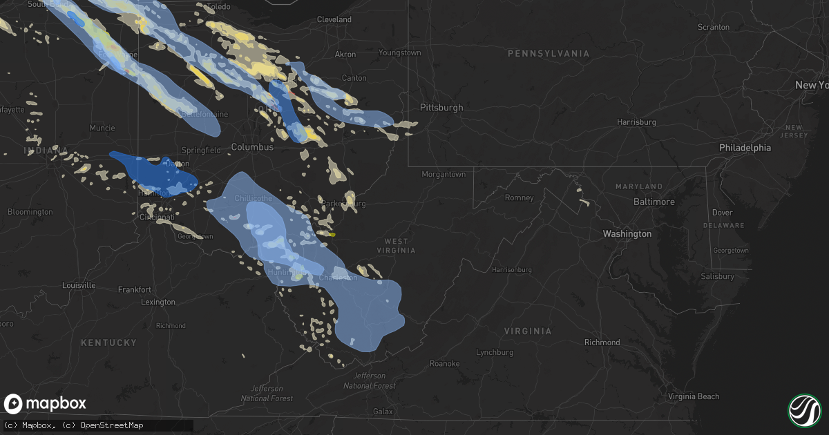
Hail Map in West Virginia on June 13, 2022
Get this storm
June 13 map
$229
one time, instant access
Download today. No call, no setup
Keep the $229
Bought the map and want the full workflow? Apply the entire $229 to a subscription within 7 days. None of it is wasted.
Every map, not just this one
This buys you this map. Subscription and you get every map we run, in the markets you choose from a few cities to whole states to nationwide. Plus real-time alerts the moment a storm fires.
Contact data
Name, contact info, occupancy, even credit band for addresses in the footprint. You go from where it hit to who to call.
Become the source they trust
Unlimited branding weather history reports on demand. You already have the documented answer ready for the property owner, and you are the one who showed up with it.
Property data and RoofTrace estimates
Pull up any address you have got, its value and the exact code rules for that jurisdiction, straight from One Click Code. Then RoofTrace estimates the squares, pitch, and roof value, priced the way you price.
Storm reports in West Virginia
West Virginia
| Date | Description |
|---|---|
| 06/13/20228:15 AM CDT | Tree down. |
| 06/13/20226:14 AM CDT | At 1111 PM EDT, severe thunderstorms were located along a line extending from 9 miles southeast of Cass Scenic Railroad to near Pearisburg, moving southeast at 30 mph. HAZARD...70 mph wind gusts. SOURCE...Radar indicated. At 10:45PM a downed tree was reported in Rainelle, West Virginia. IMPACT...Expect considerable tree damage. Damage is likely to mobile homes, roofs, and outbuildings. Locations impacted include... Blacksburg... Christiansburg... Alleghany... Covington... Clifton Forge... Lewisburg... and Pearisburg.This includes The following locations Virginia Tech and the West Virginia State Fairgrounds. |
| 06/13/20225:44 AM CDT | At 1043 PM EDT, severe thunderstorms were located along a line extending from near Camp Creek to near Tiptop, moving southeast at 30 mph. HAZARD...70 mph wind gusts. SOURCE...Radar indicated. IMPACT...Expect considerable tree damage. Damage is likely to mobile homes, roofs, and outbuildings. Locations impacted include... Bluefield... Pulaski... Wytheville... Bland... Princeton... Tazewell... and Narrows.This includes the following location, the Mercer County Airport. |
| 06/13/20225:01 AM CDT | At 1000 PM EDT, severe thunderstorms were located along a line extending from near Clay to near Burnwell to near Amherstdale-Robinette, moving east at 45 mph. HAZARD...60 mph wind gusts and penny size hail. SOURCE...Radar indicated. IMPACT...Expect damage to roofs, siding, and trees. Locations impacted include... Beckley, Summersville, Fayetteville, Richwood, Pineville, Babcock State Park, Oak Hill, Mullens, Mount Hope, Mabscott, Ansted, Oceana, Sophia, Piney View, Coal City, Prosperity, Crab Orchard, Dry Creek, Macarthur and Bradley.This includes the following highways... West Virginia Turnpike between mile markers 28 and 60. Interstate 64 in West Virginia between mile markers 120 and 137. Route 19 between mile markers 1 and 52. |
| 06/13/20224:34 AM CDT | At 931 PM EDT, severe thunderstorms were located along a line extending from 6 miles north of Cedar Grove to 7 miles west of Burnwell to 7 miles west of Van, moving southeast at 35 mph. HAZARD...60 mph wind gusts and penny size hail. SOURCE...Radar indicated. IMPACT...Damage to roofs, siding, and trees is possible. Locations impacted include... Beckley, Summersville, Fayetteville, Babcock State Park, Oak Hill, Montgomery, Chesapeake, Marmet, Mount Hope, Mabscott, Ansted, Sophia, Belle, Cedar Grove, East Bank, Glasgow, Smithers, Gauley Bridge, Pratt and Van.This includes the following highways... West Virginia Turnpike between mile markers 41 and 89. Route 19 between mile markers 1 and 44. |
| 06/13/20224:12 AM CDT | At 911 PM EDT, severe thunderstorms were located along a line extending from near Arnoldsburg to 6 miles southeast of Pinch to near Alum Creek, moving east at 45 mph. HAZARD...70 mph wind gusts and nickel size hail. SOURCE...Radar indicated. IMPACT...Expect considerable tree damage. Damage is likely to mobile homes, roofs, and outbuildings. Locations impacted include... Charleston, Nitro, Madison, Winfield, Hamlin, Clay, Jefferson, South Charleston, St. Albans, Dunbar, Hurricane, Sissonville, Montgomery, Chesapeake, Marmet, Belle, Clendenin, Cedar Grove, Poca and East Bank.This includes the following highways... Interstate 79 between mile markers 1 and 55. Interstate 77 in West Virginia between mile markers 96 and 131. Interstate 64 in West Virginia between mile markers 35 and 57. West Virginia Turnpike between mile markers 62 and 95. Route 119 between mile markers 43 and 80. |
| 06/13/20224:06 AM CDT | At 905 PM EDT, severe thunderstorms were located along a line extending from near Vienna to near Elizabeth to 7 miles west of Spencer, moving east at 55 mph. HAZARD...60 mph wind gusts and quarter size hail. SOURCE...Radar indicated. IMPACT...Hail damage to vehicles is possible. Expect wind damage to roofs, siding, and trees. Locations impacted include... Parkersburg, Marietta, Belpre, Spencer, Harrisville, St. Marys, Glenville, Elizabeth, Grantsville, Vienna, Williamstown, Pennsboro, Belmont, Mineralwells, Arnoldsburg, Cedar Creek State Park, North Bend State Park, Boaz, Newport and North Hills.This includes the following highways... Interstate 77 in West Virginia near mile marker 128, and between mile markers 161 and 186. Route 50 in West Virginia between mile markers 5 and 50. |
| 06/13/20224:01 AM CDT | At 859 PM EDT, severe thunderstorms were located along a line extending from near Barboursville to Denton, moving southeast at 40 mph. HAZARD...60 mph wind gusts and penny size hail. SOURCE...Radar indicated. IMPACT...Expect damage to roofs, siding, and trees. Locations impacted include... Louisa, Logan, Wayne, Beech Fork State Park, Yatesville Lake State Park, Chapmanville, Fort Gay, Ranger, Burnaugh, Mount Gay-Shamrock, Harts, Gill, Durbin, Ulysses, East Lynn Lake, Charley, Centerville, Webbville, Spurlockville and Chief Logan State.This includes Route 119 between mile markers 1 and 48. |
| 06/13/20223:44 AM CDT | At 843 PM EDT, severe thunderstorms were located along a line extending from 8 miles northwest of Coolville to near Forked Run State Park to 8 miles south of Racine, moving northeast at 65 mph. HAZARD...60 mph wind gusts and nickel size hail. SOURCE...Radar indicated. IMPACT...Expect damage to roofs, siding, and trees. Locations impacted include... Parkersburg, Marietta, Belpre, Ripley, Spencer, St. Marys, Elizabeth, Coolville, Forked Run State Park, Vienna, Ravenswood, Williamstown, Belmont, Sandyville, Washington, Mineralwells, Tuppers Plains, Lubeck, Boaz and Newport.This includes the following highways... Interstate 77 in West Virginia between mile markers 137 and 186. Route 50 in West Virginia between mile markers 1 and 28. |
| 06/13/20222:07 AM CDT | At 707 PM EDT, a severe thunderstorm was located over Barboursville, or near Proctorville, moving east at 25 mph. HAZARD...60 mph wind gusts and quarter size hail. SOURCE...Radar indicated. IMPACT...Hail damage to vehicles is expected. Expect wind damage to roofs, siding, and trees. Locations impacted include... Huntington, Hamlin, Chesapeake, Proctorville, Barboursville, Milton, Ona, Culloden, Burlington, Athalia, Scottown, Salt Rock, Pea Ridge and Green Bottom.This includes Interstate 64 in West Virginia between mile markers 7and 31. |
| 06/13/20221:01 AM CDT | 3-inch tree limbs broken; power poles broken. |
| 06/13/202212:17 AM CDT | Report of multiple downed trees on west alexander road... Utility trailers pushed up against each other... And roof damage. |
| 06/13/202212:16 AM CDT | Multiple trees and untility poles down |
| 06/13/202212:15 AM CDT | Damage to roof and structure... And numerous downed trees. |
| 06/13/202212:11 AM CDT | Structural damage reported from thunderstorm wind on the eastern side of town. Wv dhhr building on 16th st reportedly lost roof panels... Homes lost siding and shingles |
| 06/13/202212:11 AM CDT | Structure fire in downtown wheeling due to wind damage to utility lines. |
| 06/13/202212:10 AM CDT | Numerous trees and large branches down across wheeling city center |
| 06/12/20229:50 PM CDT | A powerline was blown down by thunderstorm winds along coal heritage road. |
| 06/12/20229:45 PM CDT | Trees uprooted or snapped. Time estimated from radar. |
| 06/12/20229:45 PM CDT | Multiple trees were blown down by thunderstorm winds along a stretch of friars hill road. |
| 06/12/20229:45 PM CDT | Report from mping: trees uprooted or snapped. Time estimated from radar. |
| 06/12/20229:45 PM CDT | Tree down on route 20 south of rainelle. |
| 06/12/20229:27 PM CDT | Multiple trees down on walkers branch rd. |
| 06/12/20229:25 PM CDT | Tree down. |
| 06/12/20229:25 PM CDT | Trees down. |
| 06/12/20229:23 PM CDT | Tree down. |
| 06/12/20229:23 PM CDT | Tree down. |
| 06/12/20229:23 PM CDT | Tree down. |
| 06/12/20229:21 PM CDT | Trees down. |
| 06/12/20229:18 PM CDT | Several trees down. |
| 06/12/20229:15 PM CDT | Couple of trees down around alum creek. Time is a radar estimate. |
| 06/12/20228:56 PM CDT | Trees and powerlines down. |
| 06/12/20228:55 PM CDT | Trees down. |
| 06/12/20228:51 PM CDT | Clay county cert reports two trees and power lines down on route 36 wallback road. |
| 06/12/20228:35 PM CDT | Tree down. |
| 06/12/20228:35 PM CDT | Few trees down. Time is radar estimated. |
| 06/12/20228:32 PM CDT | Tree down. |
| 06/12/20228:30 PM CDT | Tree down. Time is radar estimated. |
| 06/12/20228:30 PM CDT | Tree down at center street/pratt ave. |
| 06/12/20228:28 PM CDT | Multiple trees down. |
| 06/12/20228:27 PM CDT | Multiple trees down. |
| 06/12/20228:26 PM CDT | Multiple trees down. |
| 06/12/20228:25 PM CDT | Tree down. |
| 06/12/20228:25 PM CDT | Tree down. |
| 06/12/20228:23 PM CDT | Tree down. |
| 06/12/20228:20 PM CDT | 2 trees down. |
| 06/12/20228:20 PM CDT | Tree down. |
| 06/12/20228:20 PM CDT | Tree down. |
| 06/12/20228:20 PM CDT | Tree down. |
| 06/12/20228:20 PM CDT | Tree down. Lake wayne wv 3806 8243 trees down. |
| 06/12/20228:15 PM CDT | Tree down. |
| 06/12/20228:15 PM CDT | Couple of trees down around alum creek. Time is a radar estimate. |
| 06/12/20228:15 PM CDT | Tree down. |
| 06/12/20228:15 PM CDT | Tree down. |
| 06/12/20228:15 PM CDT | Tree down. |
| 06/12/20228:15 PM CDT | Tree down. |
| 06/12/20228:15 PM CDT | Corrects previous tstm wnd dmg report from 9 wsw whitesville. Tree down. |
| 06/12/20228:14 PM CDT | Report from mping: trees uprooted or snapped. |
| 06/12/20228:12 PM CDT | Tree down. |
| 06/12/20228:11 PM CDT | Spotter reports tree down on atkinson ridge road... With many power outages. Time estimated from radar. |
| 06/12/20228:11 PM CDT | Trees down. |
| 06/12/20228:10 PM CDT | Tree reported down on i-77 at mile marker 98 via wv 511. Time estimated by radar. |
| 06/12/20228:06 PM CDT | A local report indicates 1.00 inch wind near 4 NNW WEST HAMLIN |
| 06/12/20228:05 PM CDT | Trees and powerlines down. |
| 06/12/20228:00 PM CDT | Corrects previous tstm wnd dmg report from 1 ssw cross lanes. Tree down. |
| 06/12/20228:00 PM CDT | Tree down. |
| 06/12/20228:00 PM CDT | Tree down in road. |
| 06/12/20228:00 PM CDT | Tree down. |
| 06/12/20227:55 PM CDT | Tree blocking buck run road... Reported via social media. Time estimated from radar. |
| 06/12/20227:53 PM CDT | Large limbs down. Power out. |
| 06/12/20227:53 PM CDT | Trained spotter reports tree down on state route 68. Time estimated from radar. |
| 06/12/20227:45 PM CDT | Corrects previous tstm wnd dmg report from 5 ene leon. Trees uprooted or snapped. Time estimated from radar. |
| 06/12/20227:45 PM CDT | Tree down in road. |
| 06/12/20227:42 PM CDT | Large tree down on ashton street. Time estimated from radar. |
| 06/12/20227:42 PM CDT | Multiple trees down. |
| 06/12/20227:40 PM CDT | Trees down. |
| 06/12/20227:38 PM CDT | Trees uprooted or snapped; roof blown off. |
| 06/12/20227:35 PM CDT | Tree reported down on i-64 westbound by wv 511. Time estimated from radar. |
| 06/12/20227:25 PM CDT | Tree down. |
| 06/12/20227:25 PM CDT | Multiple trees down along morris street. |
All States Impacted by Hail Map on June 13, 2022
Cities Impacted by Hail Map on June 13, 2022
- Fredonia, ND
- Kulm, ND
- Aneta, ND
- Killdeer, ND
- Rugby, ND
- Pingree, ND
- Saint Michael, ND
- Cresco, IA
- Lime Springs, IA
- Courtenay, ND
- Roseau, MN
- Goodrich, ND
- Lawler, IA
- West Concord, MN
- Custer, SD
- West Olive, MI
- Fairmont, MN
- Spring Grove, MN
- Manitowoc, WI
- New Hampton, IA
- Elma, IA
- Mauston, WI
- Lyndon Station, WI
- Cashton, WI
- Westby, WI
- Kendall, WI
- Elroy, WI
- Norwalk, WI
- Ontario, WI
- Wilton, WI
- Newcastle, WY
- Niles, MI
- Buchanan, MI
- Greenwood, IN
- Amherstdale, WV
- Rushville, IN
- Berlin, ND
- Lamoure, ND
- Augusta, ME
- Windsor, ME
- Flora, IN
- Michigantown, IN
- Frankfort, IN
- Forest, IN
- Walkerton, IN
- Findlay, OH
- Valley City, ND
- Fairfield, ND
- Denhoff, ND
- Drake, ND
- Mercer, ND
- Butte, ND
- Turtle Lake, ND
- Anamoose, ND
- Mcclusky, ND
- Martin, ND
- Washburn, ND
- Harvey, ND
- Maddock, ND
- Fingal, ND
- Marion, ND
- Sanborn, ND
- Rogers, ND
- Dickey, ND
- Litchville, ND
- Luverne, ND
- Dazey, ND
- Hannaford, ND
- Pine Ridge, SD
- Oriska, ND
- Tower City, ND
- Muskegon, MI
- Shawano, WI
- Leopolis, WI
- Marion, WI
- Wilton, ND
- Wall, SD
- York, ND
- Minnesota City, MN
- Clear Lake, IA
- Thornton, IA
- Reedsville, WI
- Manville, WY
- Faulkton, SD
- Bowdon, ND
- Robinson, ND
- Woodworth, ND
- Medina, ND
- Sheyenne, ND
- Cathay, ND
- Fessenden, ND
- Sykeston, ND
- Tappen, ND
- Oberon, ND
- Pettibone, ND
- New Rockford, ND
- Carrington, ND
- Badger, MN
- Greenbush, MN
- Ipswich, SD
- Mound City, SD
- Page, ND
- Sauk City, WI
- Prairie Du Sac, WI
- Sibley, IA
- Bigelow, MN
- Worthington, MN
- Ocheyedan, IA
- Rothbury, MI
- Charlotte, MI
- Ada, MI
- Sunfield, MI
- Mulliken, MI
- Nashville, MI
- Ionia, MI
- Lake Odessa, MI
- Freeport, MI
- Clarksville, MI
- Vermontville, MI
- Portland, MI
- Lowell, MI
- Saranac, MI
- Alto, MI
- Woodland, MI
- Roscoe, SD
- Linton, ND
- Kintyre, ND
- Napoleon, ND
- Finley, ND
- Bangor, WI
- Fort Pierre, SD
- Quincy, MI
- Macatawa, MI
- Holland, MI
- Roseglen, ND
- Montpelier, ND
- Hoven, SD
- Edinburg, ND
- Hope, ND
- Westport, SD
- Agar, SD
- Onida, SD
- Spiritwood, ND
- Wimbledon, ND
- Mountain Lake, MN
- Devils Lake, ND
- Faribault, MN
- Edgeley, ND
- Wishek, ND
- Streeter, ND
- Onalaska, WI
- Gackle, ND
- Buchanan, ND
- Cleveland, ND
- Jud, ND
- Jamestown, ND
- Kathryn, ND
- Nome, ND
- Prairie City, SD
- Mud Butte, SD
- Bison, SD
- Kents Hill, ME
- Mount Vernon, ME
- Readfield, ME
- Wayne, ME
- Ulen, MN
- Hawley, MN
- Hampden, ND
- Berkey, OH
- Swanton, OH
- Holland, OH
- Uhrichsville, OH
- Tippecanoe, OH
- Gnadenhutten, OH
- Port Washington, OH
- Jay Em, WY
- Lusk, WY
- Stryker, OH
- Bryan, OH
- West Unity, OH
- Alvin, IL
- Rossville, IL
- Emmitsburg, MD
- Osage, IA
- Rockford, IA
- Nora Springs, IA
- Orchard, IA
- Charles City, IA
- Rudd, IA
- Floyd, IA
- Vermillion, SD
- Marion, OH
- Morral, OH
- Wharton, OH
- Forest, OH
- Chesterville, OH
- Benton Ridge, OH
- Bucyrus, OH
- Rawson, OH
- Harpster, OH
- Fredericktown, OH
- Galion, OH
- McComb, OH
- Kirby, OH
- Cardington, OH
- Mount Blanchard, OH
- Jenera, OH
- Nevada, OH
- Caledonia, OH
- Leipsic, OH
- Arcadia, OH
- Arlington, OH
- Mount Cory, OH
- Upper Sandusky, OH
- Mount Gilead, OH
- Carey, OH
- Edison, OH
- Houston, MN
- West Lafayette, OH
- Newcomerstown, OH
- Coshocton, OH
- Kimbolton, OH
- Kyle, SD
- London, OH
- Elgin, MN
- Waterloo, OH
- Proctorville, OH
- Oak Hill, OH
- South Webster, OH
- Pedro, OH
- Wheelersburg, OH
- Scottown, OH
- Lesage, WV
- Patriot, OH
- Crown City, OH
- Willow Wood, OH
- Gallipolis, OH
- Kitts Hill, OH
- Lance Creek, WY
- Douglas, WY
- Conklin, MI
- Ravenna, MI
- Grant, MI
- Twin Lake, MI
- Holton, MI
- Fremont, MI
- Casnovia, MI
- Whitehall, MI
- Montague, MI
- Sabina, OH
- Murdo, SD
- White River, SD
- Wood, SD
- Draper, SD
- Bourbon, IN
- Etna Green, IN
- Goshen, OH
- Decatur, IN
- Minford, OH
- Lucasville, OH
- Beaver, OH
- Jackson, OH
- Morristown, MN
- Waterville, MN
- Wellington, IL
- Milford, IL
- Sod, WV
- Yawkey, WV
- Griffithsville, WV
- Fort Dodge, IA
- Badger, IA
- Claremont, MN
- Union Mills, IN
- Shawboro, NC
- Camden, NC
- Shiloh, NC
- Fayette, OH
- Alvordton, OH
- Whitehouse, OH
- Waterville, OH
- Grand Rapids, OH
- Bringhurst, IN
- Cutler, IN
- Coldwater, MI
- Grayson, KY
- Argillite, KY
- Greenup, KY
- Milford, OH
- Cincinnati, OH
- Camp Dennison, OH
- Lynchburg, OH
- Martinsville, OH
- New Vienna, OH
- Thorntown, IN
- Stewart, OH
- Guysville, OH
- Alkol, WV
- Dresden, OH
- Conesville, OH
- Adamsville, OH
- Dingess, WV
- Alexandria, OH
- Granville, OH
- Newark, OH
- Johnstown, OH
- Danville, IL
- Westville, IL
- Elizabethton, TN
- Hillsboro, IN
- Waynetown, IN
- Veedersburg, IN
- Covington, IN
- Pomeroy, OH
- Racine, OH
- Cheshire, OH
- Bidwell, OH
- Point Pleasant, WV
- West Chester, OH
- Indianapolis, IN
- New Marshfield, OH
- McArthur, OH
- Raysal, WV
- Paynesville, WV
- Iaeger, WV
- North Adams, MI
- Hillsdale, MI
- Hudson, MI
- Pittsford, MI
- Roan Mountain, TN
- Tazewell, VA
- Tannersville, VA
- Fortville, IN
- Ceres, VA
- Letart, WV
- Terrell, NC
- Sherrills Ford, NC
- Coinjock, NC
- Barco, NC
- Bronson, MI
- Lagrange, IN
- Pleasant Lake, IN
- Burr Oak, MI
- Fremont, IN
- Mark Center, OH
- Shipshewana, IN
- Hicksville, OH
- Sturgis, MI
- Hamilton, IN
- Orland, IN
- Howe, IN
- Edgerton, OH
- Montpelier, OH
- Butler, IN
- Edon, OH
- Angola, IN
- Saltville, VA
- Marion, VA
- Chilhowie, VA
- Gobles, MI
- Paw Paw, MI
- Kalamazoo, MI
- Mattawan, MI
- Amboy, MN
- Delavan, MN
- Good Thunder, MN
- Winnebago, MN
- Minnesota Lake, MN
- Mapleton, MN
- Waseca, MN
- Owatonna, MN
- Fairburn, SD
- Buffalo Gap, SD
- Tomah, WI
- Camp Douglas, WI
- Edgemont, SD
- Hot Springs, SD
- Spring Green, WI
- Lone Rock, WI
- Presho, SD
- Holabird, SD
- Pierre, SD
- Vivian, SD
- Harrold, SD
- Highmore, SD
- Blunt, SD
- Ellendale, ND
- Hosmer, SD
- Windom, MN
- Max, ND
- Fredericksburg, OH
- Sugarcreek, OH
- Millersburg, OH
- Wilmot, OH
- Dundee, OH
- Ligonier, IN
- Cromwell, IN
- Kimmell, IN
- Wooster, OH
- Philip, SD
- Quinn, SD
- Kadoka, SD
- Scenic, SD
- Leonidas, MI
- Mendon, MI
- Chatfield, OH
- New Washington, OH
- Shelby, OH
- Bloomville, OH
- Sycamore, OH
- Crestline, OH
- Tiro, OH
- Goshen, IN
- Van Wert, OH
- Ohio City, OH
- Wanblee, SD
- Interior, SD
- Leola, SD
- Piketon, OH
- Granada, MN
- Kirklin, IN
- Clendenin, WV
- Procious, WV
- Bomont, WV
- Lizemores, WV
- Glen, WV
- Indore, WV
- Annapolis, MD
- Wilmington, OH
- Shade, OH
- Coolville, OH
- Reedsville, OH
- Dillonvale, OH
- Cadiz, OH
- Adena, OH
- Williamstown, WV
- Mineral Wells, WV
- Saint Marys, WV
- Parkersburg, WV
- Reno, OH
- Marietta, OH
- Waverly, WV
- Walker, WV
- Vienna, WV
- Davisville, WV
- Martins Ferry, OH
- Bellaire, OH
- Wheeling, WV
- Bridgeport, OH
- Saint Clairsville, OH
- Connersville, IN
- New Paris, OH
- Richmond, IN
- Eaton, OH
- Glade Spring, VA
- Bandy, VA
- North Tazewell, VA
- Mountain Rest, SC
- Salem, SC
- Tamassee, SC
- Cashiers, NC
- Midland, SD
- Java, SD
- Eagle Butte, SD
- Selby, SD
- Gettysburg, SD
- Napoleon, OH
- Defiance, OH
- Holgate, OH
- Hamilton, OH
- Goodell, IA
- Kanawha, IA
- Britt, IA
- Garner, IA
- Lawrence, MI
- Kilkenny, MN
- Three Rivers, MI
- Centreville, MI
- Williams, IA
- Dows, IA
- Blairsburg, IA
- Bellevue, OH
- Jackson Center, OH
- Lewistown, OH
- Edwardsburg, MI
- Bristol, IN
- Anna, OH
- Larwill, IN
- Arcola, IN
- Monroe, IN
- Rome City, IN
- Minster, OH
- Venedocia, OH
- Rockford, OH
- Syracuse, IN
- New Paris, IN
- Monroeville, IN
- Russells Point, OH
- Osceola, IN
- South Bend, IN
- Willshire, OH
- Avilla, IN
- New Knoxville, OH
- Pierceton, IN
- Yoder, IN
- Topeka, IN
- Albion, IN
- Mishawaka, IN
- Hoagland, IN
- Millersburg, IN
- Notre Dame, IN
- New Carlisle, IN
- Quincy, OH
- Columbia City, IN
- Bellefontaine, OH
- Lakeview, OH
- Huntertown, IN
- Convoy, OH
- Granger, IN
- Mendon, OH
- Botkins, OH
- Wapakoneta, OH
- Fort Wayne, IN
- Kendallville, IN
- Wren, OH
- Churubusco, IN
- Ossian, IN
- Middlebury, IN
- Sidney, OH
- Elkhart, IN
- Galien, MI
- Wawaka, IN
- Saint Marys, OH
- Laotto, IN
- New Bremen, OH
- Celina, OH
- Maplewood, OH
- De Graff, OH
- Spencerville, OH
- New Haven, IN
- Willard, OH
- Republic, OH
- Wayne, OH
- Burgoon, OH
- Walhonding, OH
- Dunbridge, OH
- McCutchenville, OH
- Pemberville, OH
- Shiloh, OH
- Loudonville, OH
- Bellville, OH
- Lucas, OH
- Plymouth, OH
- Bloomdale, OH
- West Millgrove, OH
- Bascom, OH
- Clyde, OH
- Bettsville, OH
- Perrysville, OH
- Danville, OH
- Bradner, OH
- Fremont, OH
- Green Springs, OH
- Ashland, OH
- Warsaw, OH
- New Riegel, OH
- Mansfield, OH
- Haskins, OH
- Bowling Green, OH
- Fostoria, OH
- Luckey, OH
- Glenmont, OH
- Lindsey, OH
- Gibsonburg, OH
- Woodville, OH
- Butler, OH
- Monroeville, OH
- Tiffin, OH
- Old Fort, OH
- North Fairfield, OH
- Perrysburg, OH
- Helena, OH
- Brinkhaven, OH
- Portage, OH
- Attica, OH
- Risingsun, OH
- Alvada, OH
- Kansas, OH
- Killbuck, OH
- Peebles, OH
- Bainbridge, OH
- Waverly, OH
- Hillsboro, OH
- Latham, OH
- Bath, IN
- Brookville, IN
- Garrison, KY
- Sunbury, OH
- Marengo, OH
- Croton, OH
- Centerburg, OH
- Corning, OH
- Shawnee, OH
- New Lexington, OH
- Highlands, NC
- Minot, ND
- Sawyer, ND
- Douglas, ND
- Ryder, ND
- Garrison, ND
- Chesapeake, VA
- Virginia Beach, VA
- Butterfield, MN
- Grassy Butte, ND
- Hammond, IN
- Chesterton, IN
- Valparaiso, IN
- Hobart, IN
- Portage, IN
- Lake Station, IN
- East Chicago, IN
- Gary, IN
- Bensenville, IL
- Huntley, IL
- Belvidere, SD
- Okaton, SD
- Hayes, SD
- Long Valley, SD
- Porcupine, SD
- Ashley, OH
- Maineville, OH
- Franklin, OH
- Culver, IN
- Gilbert, WV
- Man, WV
- Camden, IN
- Whitestown, IN
- Lebanon, IN
- Norway, IA
- Atkins, IA
- Newhall, IA
- Amana, IA
- Harrison, OH
- Cleves, OH
- East Leroy, MI
- Climax, MI
- Ceresco, MI
- Battle Creek, MI
- Galesburg, MI
- Pittsboro, IN
- Lizton, IN
- Mount Vernon, OH
- Utica, OH
- Swiss, WV
- Dayton, OH
- New Lebanon, OH
- Brookville, OH
- Vinton, OH
- Scaly Mountain, NC
- Dillard, GA
- Otto, NC
- Rabun Gap, GA
- Plymouth, IN
- Argos, IN
- Wilkinson, IN
- Charlottesville, IN
- Greenfield, IN
- Moyock, NC
- Lore City, OH
- Freeport, OH
- Mccordsville, IN
- Henderson, WV
- Southside, WV
- Leon, WV
- Gallipolis Ferry, WV
- Dakota, MN
- Squire, WV
- Carmel, IN
- Knotts Island, NC
- Albany, OH
- Frederick, SD
- Hermosa, SD
- Mercersburg, PA
- Big Cove Tannery, PA
- Warfordsburg, PA
- Needmore, PA
- Blue Creek, OH
- Vandalia, MI
- South Haven, MI
- Jones, MI
- Dowagiac, MI
- Covert, MI
- Coloma, MI
- Hartford, MI
- Watervliet, MI
- Cassopolis, MI
- Marcellus, MI
- Decatur, MI
- Bangor, MI
- Genoa, WV
- Fort Gay, WV
- Fullerton, ND
- Mooresville, NC
- Honaker, VA
- Raven, VA
- Swords Creek, VA
- Damascus, VA
- Big Prairie, OH
- Shreve, OH
- Chicago, IL
- Wanatah, IN
- Whiting, IN
- Saint James, MN
- Dover, OH
- Bolivar, OH
- Strasburg, OH
- Manning, ND
- Mandaree, ND
- Vernon Center, MN
- Garden City, MN
- Madelia, MN
- Easton, MN
- Pemberton, MN
- Waldorf, MN
- Lewisville, MN
- Medford, MN
- Janesville, MN
- New Richland, MN
- Truman, MN
- Kenyon, MN
- Farmington, ME
- Wellsburg, WV
- Washington, PA
- Hickory, PA
- Avella, PA
- Brilliant, OH
- West Alexander, PA
- Claysville, PA
- Beech Bottom, WV
- Bethany, WV
- Rayland, OH
- Evans, WV
- Summersville, WV
- Glenwood, WV
- Benedict, ND
- Meadowview, VA
- Sapphire, NC
- Lake Toxaway, NC
- Milesville, SD
- New Underwood, SD
- Onaka, SD
- Tolstoy, SD
- Bowdle, SD
- Caputa, SD
- Hurdsfield, ND
- Vienna, ME
- New Sharon, ME
- Wonewoc, WI
- Hillsboro, WI
- Monon, IN
- Cedar Rapids, IA
- Fairfax, IA
- Long Bottom, OH
- Portland, OH
- Belleville, WV
- Ravenswood, WV
- Centreville, VA
- Clifton, VA
- Manassas, VA
- Bim, WV
- Clothier, WV
- Twilight, WV
- Lewisburg, OH
- West Alexandria, OH
- Lawrenceburg, IN
- Wayne, WV
- East Lynn, WV
- Hamler, OH
- Mount Victory, OH
- Millville, WV
- Purcellville, VA
- Harpers Ferry, WV
- Lovettsville, VA
- Greensburg, IN
- Laurel, IN
- Baltic, OH
- Fresno, OH
- Paulding, OH
- Walhalla, SC
- La Crescent, MN
- Forbes, ND
- Columbus Grove, OH
- Ashley, IN
- Dunkirk, OH
- Colon, MI
- Plainwell, MI
- Ottawa, OH
- Otsego, MI
- Ada, OH
- Alger, OH
- Fulton, MI
- Allegan, MI
- Athens, MI
- Deshler, OH
- Grand Junction, MI
- Corunna, IN
- Scotts, MI
- Saint Joe, IN
- Pandora, OH
- Sherwood, OH
- Ney, OH
- Pullman, MI
- Dola, OH
- Portage, MI
- Fennville, MI
- Vicksburg, MI
- Cecil, OH
- Malinta, OH
- Schoolcraft, MI
- Harrod, OH
- Bloomingdale, MI
- Kenton, OH
- Bluffton, OH
- Constantine, MI
- Waterloo, IN
- Sherwood, MI
- Hudson, IN
- White Pigeon, MI
- Oakwood, OH
- Union City, MI
- Huntington, IN
- Roanoke, IN
- Reading, MI
- Camden, MI
- Montgomery, MI
- Goodland, IN
- Kentland, IN
- Caldwell, OH
- Dexter City, OH
- Leesburg, OH
- Dickerson, MD
- Sparta, OH
- New Plymouth, OH
- Oakwood, VA
- Grundy, VA
- Hardy, VA
- Upton, WY
- Osage, WY
- Baroda, MI
- Vanlue, OH
- Verner, WV
- Heron Lake, MN
- Piedmont, OH
- Sparta, WI
- Ladoga, IN
- Delbarton, WV
- Matewan, WV
- Ironton, OH
- South Point, OH
- Hardy, IA
- Thor, IA
- Klemme, IA
- Goldfield, IA
- Renwick, IA
- Eagle Grove, IA
- Mount Perry, OH
- Somerset, OH
- Roseville, OH
- White Cottage, OH
- Zanesville, OH
- Washington, WV
- Riceville, IA
- Greenfield, OH
- Oronoco, MN
- Pine Island, MN
- Zumbro Falls, MN
- Rochester, MN
- Norwich, OH
- Nashport, OH
- Hopewell, OH
- Saint Louisville, OH
- Trinway, OH
- Frazeysburg, OH
- Heath, OH
- Friendship, WI
- Browntown, WI
- Monroe, WI
- Argyle, WI
- Pataskala, OH
- Valley Grove, WV
- Hamlet, IN
- West Lebanon, IN
- Williamsport, IN
- Monroe, OH
- Clarksville, OH
- Morrow, OH
- Lebanon, OH
- Middletown, OH
- Waynesville, OH
- Oregonia, OH
- South Lebanon, OH
- Blanchester, OH
- Liberty, IN
- Amigo, WV
- Mullens, WV
- Herndon, WV
- Itmann, WV
- Elizabeth City, NC
- Crooksville, OH
- Batavia, OH
- Mohawk, WV
- Panther, WV
- Eastover, SC
- Gadsden, SC
- Fulda, MN
- Westbrook, MN
- Newell, SD
- Holmesville, OH
- Blue Earth, MN
- Saugatuck, MI
- Collison, IL
- Potomac, IL
- Shelbyville, IN
- Manilla, IN
- Black Earth, WI
- Cross Plains, WI
- Mazomanie, WI
- Cottage Grove, WI
- Waterloo, WI
- Marshall, WI
- Windsor, WI
- Madison, WI
- Sun Prairie, WI
- Deerfield, WI
- Deforest, WI
- Quinwood, WV
- Sullivan, WI
- Oconomowoc, WI
- Helenville, WI
- Dousman, WI
- North Spring, WV
- Ikes Fork, WV
- Mcconnelsville, OH
- Lowell, OH
- Beverly, OH
- Hatton, ND
- Caledonia, MN
- Hokah, MN
- Litchfield, MI
- Allen, MI
- Jonesville, MI
- Osseo, MI
- Morenci, MI
- Jerome, MI
- Sullivan, OH
- Nova, OH
- Newport, KY
- Fort Thomas, KY
- Latonia, KY
- Hamersville, OH
- Ripley, OH
- Russellville, OH
- Georgetown, OH
- Covington, KY
- Melbourne, KY
- Amelia, OH
- New Richmond, OH
- Bethel, OH
- Silver Grove, KY
- Lyburn, WV
- Omar, WV
- Holden, WV
- Logan, WV
- Stollings, WV
- Switzer, WV
- West College Corner, IN
- Pleasant Plain, OH
- Cottageville, WV
- Ripley, WV
- Millwood, WV
- Rutland, OH
- Langsville, OH
- Logan, OH
- Madison, WV
- Milroy, IN
- Carpentersville, IL
- Palatine, IL
- Elmwood Park, IL
- Oak Park, IL
- Forest Park, IL
- Elmhurst, IL
- Arlington Heights, IL
- Des Plaines, IL
- Berwyn, IL
- River Forest, IL
- Cicero, IL
- Wood Dale, IL
- Mount Prospect, IL
- River Grove, IL
- Park Ridge, IL
- Schiller Park, IL
- Elk Grove Village, IL
- Barrington, IL
- Bellwood, IL
- Franklin Park, IL
- Prospect Heights, IL
- Rolling Meadows, IL
- Hoffman Estates, IL
- Melrose Park, IL
- Harwood Heights, IL
- Stone Park, IL
- Maywood, IL
- Schaumburg, IL
- Muskego, WI
- Franklin, WI
- Dane, WI
- Lake Mills, WI
- Hartland, WI
- Jefferson, WI
- Waunakee, WI
- Delafield, WI
- Ixonia, WI
- Wales, WI
- Brookfield, WI
- North Prairie, WI
- Cambridge, WI
- Watertown, WI
- South Milwaukee, WI
- Middleton, WI
- Fort Atkinson, WI
- Palmyra, WI
- Oak Creek, WI
- Waukesha, WI
- Cudahy, WI
- New Berlin, WI
- Hales Corners, WI
- Nashotah, WI
- Pewaukee, WI
- Big Bend, WI
- Mukwonago, WI
- Greendale, WI
- Johnson Creek, WI
- Milwaukee, WI
- Eagle, WI
- Morristown, IN
- Carthage, IN
- Arlington, IN
- Caledonia, WI
- Lodi, WI
- Elm Grove, WI
- Lawton, MI
- Okauchee, WI
- Columbus, WI
- Stoughton, WI
- Mcfarland, WI
- Saint Francis, WI
- Racine, WI
- Kent City, MI
- Sparta, MI
- Hartington, NE
- Fordyce, NE
- Sylvania, OH
- Toledo, OH
- Maumee, OH
- New Philadelphia, OH
- Mineral City, OH
- Apple Creek, OH
- Lakeville, OH
- Beach City, OH
- Storden, MN
- Jeffers, MN
- Bingham Lake, MN
- Prichard, WV
- Winona, MN
- Rushford, MN
- Lewiston, MN
- Shell Rock, IA
- Roselle, IL
- Itasca, IL
- Gilberts, IL
- Berkeley, IL
- Riverside, IL
- Broadview, IL
- Wheeling, IL
- Glenview, IL
- Fox River Grove, IL
- Lake In The Hills, IL
- Lincolnwood, IL
- Hanover Park, IL
- Westchester, IL
- Algonquin, IL
- Dundee, IL
- Elgin, IL
- Hanna, IN
- Hines, IL
- Addison, IL
- La Crosse, IN
- Niles, IL
- Streamwood, IL
- Medinah, IL
- Hillside, IL
- Tekonsha, MI
- Enderlin, ND
- Cozad, NE
- Jeromesville, OH
- Glenwood, IN
- Leeds, ME
- Gwynneville, IN
- Fountaintown, IN
- Miamisburg, OH
- Germantown, OH
- Knox, IN
- Grovertown, IN
- Danville, WV
- Cumberland, OH
- Chandlersville, OH
- Stockport, OH
- Coal Run, OH
- Macksburg, OH
- Blue Rock, OH
- Waterford, OH
- Emmalena, KY
- Hazard, KY
- Ary, KY
- Continental, OH
- New Bavaria, OH
- Middleport, OH
- West Columbia, WV
- Mason, WV
- Wilkesville, OH
- Cyclone, WV
- Clear Fork, WV
- Simon, WV
- Coal Mountain, WV
- Davin, WV
- Milton, WV
- Branchland, WV
- Hurricane, WV
- Salt Rock, WV
- Chesapeake, OH
- Ona, WV
- Huntington, WV
- West Hamlin, WV
- Hamlin, WV
- Barboursville, WV
- Culloden, WV
- South Charleston, WV
- Elkview, WV
- Tad, WV
- Dunbar, WV
- Charleston, WV
- Concord, NC
- Huntersville, NC
- Davidson, NC
- Phelps, KY
- Hurley, VA
- Stopover, KY
- North Monmouth, ME
- Plain, WI
- Gotham, WI
- Winthrop, ME
- Hoopeston, IL
- Henning, IL
- La Rue, OH
- Ridgeway, OH
- Wallback, WV
- Maysel, WV
- Clay, WV
- Wharncliffe, WV
- Dennison, OH
- Tuscarawas, OH
- Mason City, IA
- Polk, OH
- West Salem, OH
- Shepherdstown, WV
- Sharpsburg, MD
- Oakes, ND
- Eureka, SD
- Aberdeen, SD
- Oral, SD
- Callaway, NE
- Liberty Center, OH
- Hewett, WV
- Turtle Creek, WV
- Pioneer, OH
- Philo, OH
- Russell, KY
- Flatwoods, KY
- Oxford, OH
- Trenton, OH
- Johnson City, TN
- Yolyn, WV
- Goodview, VA
- Vassalboro, ME
- Belgrade, ME
- Ellendale, MN
- Mindoro, WI
- Trempealeau, WI
- Holmen, WI
- La Crosse, WI
- West Salem, WI
- Greenwich, OH
- Stone Creek, OH
- Nelsonville, OH
- Great Falls, VA
- Poolesville, MD
- Sterling, VA
- Stout, OH
- Vanceburg, KY
- Berwind, WV
- Pounding Mill, VA
- Cedar Bluff, VA
- Richlands, VA
- Springer, OK
- Morton Grove, IL
- Fort Totten, ND
- Crary, ND
- Warwick, ND
- Verona, ND
- Middle River, MN
- Thief River Falls, MN
- Inkster, ND
- Dahlen, ND
- Grafton, ND
- Saint Thomas, ND
- Strandquist, MN
- Fisher, MN
- Viking, MN
- Stephen, MN
- Hoople, ND
- Saint Vincent, MN
- Portland, ND
- Gilby, ND
- Mayville, ND
- Lancaster, MN
- Binford, ND
- Warren, MN
- Pisek, ND
- Forest River, ND
- Alvarado, MN
- Clifford, ND
- Kennedy, MN
- Grygla, MN
- Karlstad, MN
- Pembina, ND
- Lisbon, ND
- Goodridge, MN
- Fort Ransom, ND
- Buffalo, ND
- Grand Forks, ND
- Bathgate, ND
- Donaldson, MN
- Mcville, ND
- Reynolds, ND
- Oslo, MN
- Lakota, ND
- Gatzke, MN
- Thompson, ND
- Lake Bronson, MN
- Mchenry, ND
- Arvilla, ND
- Wannaska, MN
- Sharon, ND
- Drayton, ND
- Strathcona, MN
- Michigan, ND
- Niagara, ND
- Park River, ND
- Argyle, MN
- Manvel, ND
- Fordville, ND
- Crystal, ND
- East Grand Forks, MN
- Jessie, ND
- Mekinock, ND
- Larimore, ND
- Ypsilanti, ND
- Glasston, ND
- Grand Forks Afb, ND
- Cooperstown, ND
- Halma, MN
- Pekin, ND
- Pillsbury, ND
- Newfolden, MN
- Humboldt, MN
- Petersburg, ND
- Hamilton, ND
- Northwood, ND
- Minto, ND
- Sutton, ND
- Lankin, ND
- Emerado, ND
- Gwinner, ND
- Hallock, MN
- Viborg, SD
- Gayville, SD
- Centerville, SD
- Beresford, SD
- Irene, SD
- Saint Helena, NE
- Wakonda, SD
- Worthing, SD
- Yankton, SD
- Canton, SD
- Lennox, SD
- Volin, SD
- Davis, SD
- Mission Hill, SD
- Corwith, IA
- Harrison, NE
- Sandyville, WV
- South Elgin, IL
- Bartlett, IL
- Bloomingdale, IL
- Lyons, IL
- La Grange, IL
- Skokie, IL
- Summit Argo, IL
- Burbank, IL
- Brookfield, IL
- La Grange Park, IL
- Verona, WI
- Archbold, OH
- Wauseon, OH
- Hoytville, OH
- Van Buren, OH
- Waldron, MI
- North Baltimore, OH
- Wolcottville, IN
- Miller City, OH
- Custar, OH
- Ridgeville Corners, OH
- Cygnet, OH
- Williamstown, OH
- Evansport, OH
- Buckland, OH
- Pemberton, OH
- Belle Center, OH
- West Liberty, OH
- Saint Paris, OH
- Nappanee, IN
- New Hampshire, OH
- Rosewood, OH
- Uniopolis, OH
- Wakarusa, IN
- Milford, IN
- North Webster, IN
- Marysville, OH
- Huntsville, OH
- Zanesfield, OH
- Lima, OH
- Leesburg, IN
- Middle Point, OH
- Woodstock, OH
- Mechanicsburg, OH
- Mingo, OH
- Port Jefferson, OH
- Waynesfield, OH
- Milford Center, OH
- North Lewisburg, OH
- Conover, OH
- East Liberty, OH
- Urbana, OH
- Warsaw, IN
- Rushsylvania, OH
- Delphos, OH
- Cable, OH
- Hopedale, OH
- Scio, OH
- Jewett, OH
- Bloomingdale, OH
- Flushing, OH
- Smithfield, OH
- Bowerston, OH
- Artie, WV
- Alderson, WV
- Lerona, WV
- Tornado, WV
- Red House, WV
- Frankfort, OH
- New Richmond, WV
- Mount Carbon, WV
- Dorothy, WV
- Ashland, KY
- Pond Gap, WV
- Brenton, WV
- Catlettsburg, KY
- Athens, WV
- Nettie, WV
- Washington Court House, OH
- Londonderry, OH
- Maben, WV
- Matheny, WV
- Canvas, WV
- Colcord, WV
- Blount, WV
- Fayetteville, WV
- Crab Orchard, WV
- Victor, WV
- Rainelle, WV
- East Bank, WV
- Racine, WV
- Glen White, WV
- Meadow Bridge, WV
- Jumping Branch, WV
- Oceana, WV
- Whitesville, WV
- Layland, WV
- Powellton, WV
- Mount Nebo, WV
- Pence Springs, WV
- Camp Creek, WV
- Orgas, WV
- Handley, WV
- Winfield, WV
- Arnett, WV
- Nellis, WV
- Portsmouth, OH
- Costa, WV
- Princewick, WV
- Pool, WV
- Montgomery, WV
- McDermott, OH
- Miami, WV
- Fenwick, WV
- Hico, WV
- Otway, OH
- Glen Fork, WV
- Hansford, WV
- Ghent, WV
- South Salem, OH
- Belva, WV
- Asbury, WV
- Ravencliff, WV
- Crawley, WV
- Saint Albans, WV
- Saulsville, WV
- Ashford, WV
- Rhodell, WV
- Nitro, WV
- Seth, WV
- Beckley, WV
- Clear Creek, WV
- Pineville, WV
- Pratt, WV
- Lavalette, WV
- Jesse, WV
- Friendship, OH
- Glen Daniel, WV
- Green Sulphur Springs, WV
- Laurelville, OH
- Fairdale, WV
- Drennen, WV
- Beaver, WV
- Ansted, WV
- Richmond Dale, OH
- Scarbro, WV
- South Shore, KY
- Saxon, WV
- Spanishburg, WV
- Rock, WV
- Rupert, WV
- Surveyor, WV
- Stephenson, WV
- Meadow Creek, WV
- Cedar Grove, WV
- Drybranch, WV
- Poca, WV
- Worthington, KY
- Shady Spring, WV
- Kincaid, WV
- Rock Creek, WV
- Thurmond, WV
- Odd, WV
- Bolt, WV
- London, WV
- Wellston, OH
- Sophia, WV
- Coalton, OH
- Rush, KY
- Pipestem, WV
- Midway, WV
- Princeton, WV
- Given, WV
- Talcott, WV
- Grassy Meadows, WV
- South Bloomingville, OH
- Kenna, WV
- Naoma, WV
- Cool Ridge, WV
- Ceredo, WV
- Danese, WV
- Lookout, WV
- Williamsport, OH
- Circleville, OH
- Scott Depot, WV
- Mount Hope, WV
- Wharton, WV
- Gallagher, WV
- Eskdale, WV
- Glasgow, WV
- Rio Grande, OH
- Lashmeet, WV
- Daniels, WV
- Sylvester, WV
- Cabin Creek, WV
- Glen Jean, WV
- Winifrede, WV
- Hinton, WV
- Liberty, WV
- Spring Dale, WV
- Coal City, WV
- Mount Lookout, WV
- Belle, WV
- Rarden, OH
- Thurman, OH
- Nimitz, WV
- Apple Grove, WV
- Lester, WV
- Peytona, WV
- Quincy, KY
- Buffalo, WV
- Bloomingrose, WV
- Oak Hill, WV
- Matoaka, WV
- Mount Sterling, OH
- Dixie, WV
- Eleanor, WV
- Gauley Bridge, WV
- Hernshaw, WV
- Foster, WV
- Comfort, WV
- Ray, OH
- Nallen, WV
- Ashton, WV
- Charmco, WV
- New Holland, OH
- Beeson, WV
- Ridgeview, WV
- Lansing, WV
- Leivasy, WV
- Kanawha Falls, WV
- Wyoming, WV
- Smithers, WV
- South Portsmouth, KY
- Kingston, OH
- Chillicothe, OH
- Fraziers Bottom, WV
- Sumerco, WV
- Hugheston, WV
- West Portsmouth, OH
- Clarksburg, OH
- Smoot, WV
- Richwood, WV
- Sandstone, WV
- Glen Rogers, WV
- Kenova, WV
- Flat Top, WV
- Edmond, WV
- Kimberly, WV
- Robson, WV
- White Oak, WV
- Alum Creek, WV
- Dry Creek, WV
- Slab Fork, WV
- Mammoth, WV
- Franklin Furnace, OH
- Josephine, WV
- Hamden, OH
- Greens Fork, IN
- College Corner, OH
- Camden, OH
- Kings Mills, OH
- Seven Mile, OH
- Brownsville, IN
- Xenia, OH
- Cambridge City, IN
- Milton, IN
- Harveysburg, OH
- Springboro, OH
- New Castle, IN
- Clayton, OH
- Spring Valley, OH
- Farmersville, OH
- Boston, IN
- Centerville, IN
- Straughn, IN
- Hagerstown, IN
- Mason, OH
- Bellbrook, OH
- Somerville, OH
- Gambier, OH
- Martinsburg, OH
- Howard, OH


