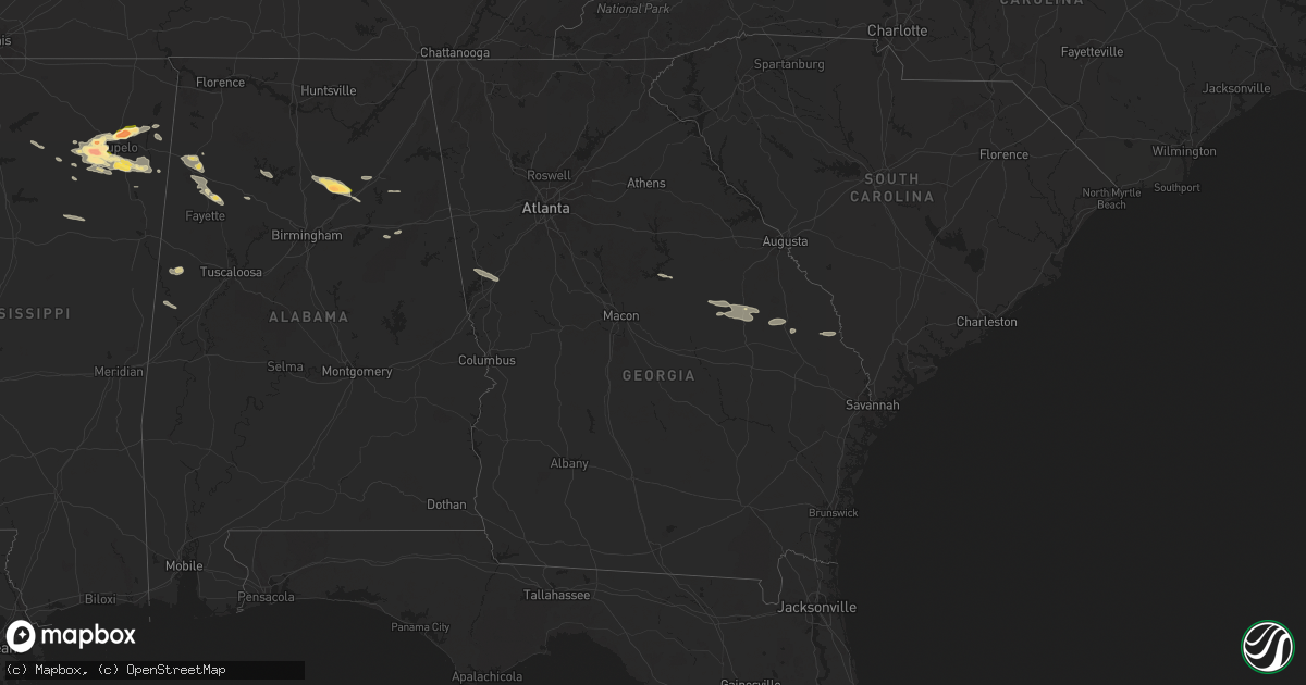
Hail Map in Georgia on June 9, 2024
Get this storm
June 9 map
$229
one time, instant access
Download today. No call, no setup
Keep the $229
Bought the map and want the full workflow? Apply the entire $229 to a subscription within 7 days. None of it is wasted.
Every map, not just this one
This buys you this map. Subscription and you get every map we run, in the markets you choose from a few cities to whole states to nationwide. Plus real-time alerts the moment a storm fires.
Contact data
Name, contact info, occupancy, even credit band for addresses in the footprint. You go from where it hit to who to call.
Become the source they trust
Unlimited branding weather history reports on demand. You already have the documented answer ready for the property owner, and you are the one who showed up with it.
Property data and RoofTrace estimates
Pull up any address you have got, its value and the exact code rules for that jurisdiction, straight from One Click Code. Then RoofTrace estimates the squares, pitch, and roof value, priced the way you price.
Storm reports in Georgia
Georgia
| Date | Description |
|---|---|
| 06/09/20244:50 AM CDT | Burke county em reported trees down on allen chapel road. |
| 06/09/20244:45 AM CDT | Burke county em reported a down tree blocking river road near hwy 80. |
| 06/09/20244:38 AM CDT | Two trees reported down on poor robin rd and highway 24. 700 people reported without power. |
| 06/09/20244:07 AM CDT | Thunderstorm wind gust downed a tree in the city limits of millen. The tree fell on some nearby power lines and transformer. Time estimated from radar data. |
| 06/09/20244:06 AM CDT | Tree reported down on transformer at 489 s. Gray street in millen. |
| 06/09/20243:45 AM CDT | Tree down across pea ridge rd. |
| 06/09/20243:45 AM CDT | Tree down across possum point dr. |
| 06/09/20243:45 AM CDT | Two trees down across 700 block of milledgeville rd. |
| 06/09/20243:45 AM CDT | Tree down across pine knoll ct. |
| 06/09/20243:40 AM CDT | Tree down across 500 block of dennis station rd. |
| 06/09/20243:40 AM CDT | Tree down across twin bridges rd. |
| 06/09/20243:38 AM CDT | Burke county dispatch reports multiple trees down on hwy 56 near frank farmer rd. Time estimated from kclx radar. |
All States Impacted by Hail Map on June 9, 2024
Cities Impacted by Hail Map on June 9, 2024
- Paragould, AR
- Cardwell, MO
- Arbyrd, MO
- West Plains, MO
- Mammoth Spring, AR
- Thayer, MO
- Koshkonong, MO
- Salem, AR
- Williford, AR
- Hardy, AR
- Ravenden, AR
- Ravenden Springs, AR
- Pocahontas, AR
- Beech Grove, AR
- Marmaduke, AR
- Leachville, AR
- Senath, MO
- Hornersville, MO
- Manila, AR
- Fort McKavett, TX
- Mason, TX
- Westcliffe, CO
- Pettigrew, AR
- Deer, AR
- Sedalia, CO
- Roswell, NM
- San Angelo, TX
- Christoval, TX
- Castle Rock, CO
- Stonewall, OK
- Hagarville, AR
- Howard, CO
- Cotopaxi, CO
- Tupelo, OK
- Allen, OK
- Mcalester, OK
- Idalou, TX
- Muleshoe, TX
- Shawnee, CO
- Centrahoma, OK
- Bennett, CO
- Atkins, AR
- Jerusalem, AR
- Bailey, CO
- Abernathy, TX
- Hector, AR
- Lorenzo, TX
- Jackpot, NV
- Carson, NM
- Springfield, AR
- Portales, NM
- Earth, TX
- Savanna, OK
- Watkins, CO
- Hattieville, AR
- Greenbrier, AR
- Damascus, AR
- Hansen, ID
- Stuart, OK
- Wardville, OK
- Lubbock, TX
- Ozark, AR
- Socorro, NM
- Kiowa, OK
- Ojo Caliente, NM
- Russellville, AR
- Declo, ID
- Rupert, ID
- Coalgate, OK
- Elida, NM
- Sudan, TX
- Artesia, NM
- Eldorado, TX
- Albuquerque, NM
- Burley, ID
- Oakley, ID
- Murtaugh, ID
- Ocate, NM
- Farwell, TX
- Robert Lee, TX
- Cleveland, AR
- Menard, TX
- Hagerman, NM
- Texico, NM
- Center Ridge, AR
- Bovina, TX
- Morrilton, AR
- Clovis, NM
- Conway, AR
- Vilonia, AR
- Paris, AR
- Eupora, MS
- Hale Center, TX
- Littlefield, TX
- Amherst, TX
- Pontotoc, MS
- Rogers, NM
- Sterling City, TX
- Fieldton, TX
- Parker, CO
- Garden City, TX
- Plumerville, AR
- Jefferson, CO
- Mantee, MS
- Aurora, CO
- Floyd, NM
- Clarksville, AR
- Los Alamos, NM
- Maben, MS
- Kirtland Afb, NM
- Slaton, TX
- Big Lake, TX
- Midland, TX
- Shannon, MS
- Tupelo, MS
- Cabot, AR
- Thaxton, MS
- Taiban, NM
- Bee Branch, AR
- Lamar, AR
- Melrose, NM
- Denver, CO
- Commerce City, CO
- Belden, MS
- Mathiston, MS
- Plantersville, MS
- American Falls, ID
- Blanca, CO
- Olton, TX
- Pocatello, ID
- North Little Rock, AR
- Platteville, CO
- Jordan Valley, OR
- Fort Lupton, CO
- Ralls, TX
- Solgohachia, AR
- Lonoke, AR
- Oxford, MS
- Taylor, MS
- Enochs, TX
- Junction, TX
- Maumelle, AR
- Wilburton, OK
- Nettleton, MS
- Ecru, MS
- Blue Springs, MS
- Littleton, CO
- Mayflower, AR
- La Salle, CO
- Fairplay, CO
- Water Valley, MS
- Hazen, AR
- Riverside, OR
- Sonora, TX
- Amory, MS
- Magazine, AR
- Fulton, MS
- Springlake, TX
- Smithville, MS
- Fort Sumner, NM
- Stuttgart, AR
- De Valls Bluff, AR
- Mill Creek, OK
- Hamilton, AL
- Santa Rosa, NM
- Cerrillos, NM
- Randolph, MS
- Houlka, MS
- Okolona, MS
- Greenwood Springs, MS
- Morton, TX
- Ririe, ID
- Rexburg, ID
- Tishomingo, OK
- Scott, AR
- Aliceville, AL
- Guin, AL
- Firth, ID
- Wister, OK
- Lone Tree, CO
- Trinidad, CO
- Weston, CO
- Hartshorne, OK
- Boligee, AL
- House, NM
- Franktown, CO
- Friona, TX
- Larkspur, CO
- Princeton, OR
- Ardmore, OK
- Oneonta, AL
- Cleveland, AL
- Trinchera, CO
- Model, CO
- Walsenburg, CO
- Mannsville, OK
- Lamy, NM
- Saltillo, MS
- Hayden, AL
- Moffat, CO
- Little Rock, AR
- Golden, MS
- Cuervo, NM
- Guntown, MS
- Baldwyn, MS
- Snyder, TX
- Mantachie, MS
- Tucumcari, NM
- Brilliant, AL
- Ashville, AL
- Iowa Park, TX
- Madill, OK
- Denio, NV
- Sulphur, OK
- Marietta, MS
- Aspermont, TX
- Old Glory, TX
- Red Oak, OK
- Pueblo, CO
- Girard, TX
- Jayton, TX
- Rye, CO
- Byers, TX
- Temple, OK
- Carrollton, AL
- Hastings, OK
- Spur, TX
- Springer, OK
- Vardaman, MS
- Ryan, OK
- Inkom, ID
- Paducah, TX
- Arley, AL
- Medicine Bow, WY
- Winfield, AL
- Electra, TX
- Fayette, AL
- Eldridge, AL
- Springville, AL
- Knox City, TX
- Carlisle, AR
- England, AR
- Lone Grove, OK
- Almira, WA
- Dickens, TX
- Bankston, AL
- Sherwood, AR
- Jacksonville, AR
- Wilbur, WA
- Odessa, WA
- Wilson, OK
- Marietta, OK
- Overbrook, OK
- Waurika, OK
- Burneyville, OK
- Attalla, AL
- Gallant, AL
- Weinert, TX
- Odessa, TX
- Barnhart, TX
- Roosevelt, TX
- Helotes, TX
- San Antonio, TX
- Bigelow, AR
- Victor, ID
- Goldsmith, TX
- Crowell, TX
- Goree, TX
- Scotland, TX
- Windthorst, TX
- Munday, TX
- Rochester, TX
- Holliday, TX
- Jbsa Lackland, TX
- Atascosa, TX
- Rule, TX
- Happy, TX
- Von Ormy, TX
- Mountain Home, TX
- Maxwell, NM
- Midkiff, TX
- Pavillion, WY
- Leakey, TX
- Ringling, OK
- Justiceburg, TX
- Grandfalls, TX
- Gadsden, AL
- Wellington, AL
- Jacksonville, AL
- Odonnell, TX
- Utopia, TX
- Crane, TX
- Haskell, TX
- Post, TX
- Tahoka, TX
- McCamey, TX
- Seymour, TX
- Beaverton, AL
- Hackleburg, AL
- Carbon Hill, AL
- Stanton, TX
- Jasper, AL
- Townley, AL
- Rocksprings, TX
- Davisboro, GA
- Bartow, GA
- Wadley, GA
- Ozona, TX
- Midville, GA
- Swainsboro, GA
- Louisville, GA
- Pawleys Island, SC
- Georgetown, SC
- Millen, GA
- Fort Stockton, TX
- Comstock, TX
- Hunt, TX
- Sparta, GA
- Blytheville, AR
- Milledgeville, GA
- Harper, TX
- Franklin, GA
- Hogansville, GA
- Talladega, AL
- Munford, AL
- Del Rio, TX
- Sandersville, GA
- Rocky Ford, GA
- Sylvania, GA
- Uvalde, TX
- Hondo, TX
- Allendale, SC
- Martin, SC
- Natalia, TX
- Devine, TX
- Castroville, TX
- La Coste, TX
- Moore, TX
- Mico, TX
- Fairfax, SC
- Ulmer, SC
- Lytle, TX
- Poteet, TX
- Bigfoot, TX
- Somerset, TX
- Camp Wood, TX


