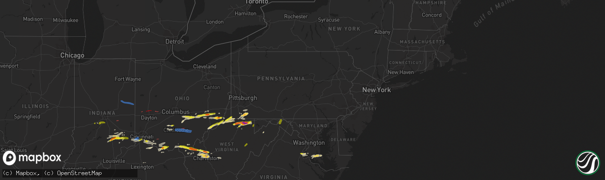
Hail Map in Pennsylvania on June 8, 2022
The weather event in Pennsylvania on June 8, 2022 includes Hail, Wind, and Tornado maps. 21 states and 673 cities were impacted and suffered possible damage. The total estimated number of properties impacted is 107.
Want more than just the map?
Turn this storm into a full workflow.
- Owner + property data so you know who to knock
- OnDemand branded weather history reports to win the "did we even have hail?" argument
- RoofTrace estimate so reps stop guessing numbers at the door
Bought this map? Upgrade within 7 days and we'll credit the $230. (10-15 min setup call)
Hail
Wind
Tornado
107
Estimated number of impacted properties by a 1.00" hail or larger0
Estimated number of impacted properties by a 1.75" hail or larger0
Estimated number of impacted properties by a 2.50" hail or largerStorm reports in Pennsylvania
Pennsylvania
| Date | Description |
|---|---|
| 06/08/20226:26 AM CDT | At 1126 PM EDT, a severe thunderstorm was located over Cessna, moving northeast at 50 mph. HAZARD...60 mph wind gusts. SOURCE...Radar indicated. IMPACT...Expect damage to roofs, siding, and trees. Locations impacted include... Bedford, New Enterprise, Osterburg, St. Clairsville, Cessna, Saxton, Manns Choice, Woodbury, Defiance and Hopewell.This includes the following Interstates... The Pennsylvania Turnpike from mile markers 140 to 150. Interstate 99 from mile markers 0 to 10. |
| 06/08/20225:46 AM CDT | At 1046 PM EDT, a severe thunderstorm was located over Berlin, moving northeast at 35 mph. HAZARD...60 mph wind gusts. SOURCE...Radar indicated. IMPACT...Expect damage to roofs, siding, and trees. Locations impacted include... Berlin, Buffalo Mills, Indian Lake, Schellsburg, Manns Choice, New Paris and New Baltimore.This includes The Pennsylvania Turnpike from mile markers 120 to 142. |
| 06/08/20225:16 AM CDT | At 1016 PM EDT, a severe thunderstorm was located 7 miles north of Fairview, or 12 miles north of Mannington, moving east at 35 mph. HAZARD...60 mph wind gusts. SOURCE...Radar indicated. IMPACT...Expect damage to trees and power lines, resulting in some power outages. Locations impacted include... Morgantown, Westover, Star City, Point Marion, Granville, Fairview, Cassville, Brookhaven, Bobtown, Greensboro, Blacksville, and Spraggs. |
| 06/08/20222:48 AM CDT | At 748 PM EDT, a severe thunderstorm was located 8 miles south of Cameron, or 12 miles east of New Martinsville, moving northeast at 25 mph. HAZARD...60 mph wind gusts and half dollar size hail. SOURCE...Radar indicated. IMPACT...Minor hail damage to vehicles is possible. Expect wind damage to trees and power lines, resulting in some power outages. Locations impacted include... Cameron, Hundred, Aleppo, New Freeport, Rocklick, Lynn Camp, Lone Oak, Glen Easton, Knob Fork, Beelers Station, and Littleton. |
| 06/07/202210:40 PM CDT | Tree down at 1879 berlin plank rd between somerset and berlin. |
| 06/07/202210:35 PM CDT | Ema/nws coordinated damage assessment determined non-tornadic... Straight-line wind damage |
| 06/07/202210:30 PM CDT | Multiple trees down on berry rd. Near pa653 between rockwood and new centerville. |
| 06/07/20229:50 PM CDT | Tree down 9651 glades pike. |
| 06/07/20229:46 PM CDT | Power lines down near pleasant drive and main street |
| 06/07/20229:43 PM CDT | Vehicle struck a tree blocking the road on south eighty road near donham road. |
| 06/07/20229:18 PM CDT | Multiple trees down near 294 toms run road. |
| 06/07/20229:17 PM CDT | Trustin run road impassable due to downed tree. |
| 06/07/20228:40 PM CDT | Trees and wires down along covered bridge road in middlecreek township. |
| 06/07/20228:30 PM CDT | Sporadic reports of trees down across addison... Upper turkeyfoot... And lower turkeyfoot townships. |
| 06/07/20228:18 PM CDT | Several trees down... Time estimated by radar |
| 06/07/20227:59 PM CDT | Several trees down... Time estimated by radar |
| 06/07/20227:59 PM CDT | Several trees down... Time estimated by radar |
| 06/07/20227:55 PM CDT | A local report indicates 2.00 inch wind near MASONTOWN |
| 06/07/20227:50 PM CDT | Trees down. Time estimate from radar |
| 06/07/20227:30 PM CDT | Nws storm survey discovered scattered tree damage along a half mile stretch of sr 3013 just southwest of oak grove. Large limbs and branches up to 6 inches in diameter |
| 06/07/20227:20 PM CDT | Multiple trees down in wayne twp... Gilmore twp along tustin rd and toms run rd. Time estimate based from radar |
| 06/07/20227:10 PM CDT | Trees down. Time estimate based from radar |
All States Impacted by Hail Map on June 8, 2022
Cities Impacted by Hail Map on June 8, 2022
- Chouteau, OK
- Elizabethtown, IN
- Seymour, IN
- Butlerville, IN
- Versailles, IN
- Osgood, IN
- Scipio, IN
- Jonesville, IN
- Holton, IN
- Brownstown, IN
- Westport, IN
- Columbus, IN
- Greensburg, IN
- North Vernon, IN
- Madison, IN
- Sarahsville, OH
- Woodsfield, OH
- Beallsville, OH
- Summerfield, OH
- Caldwell, OH
- Lewisville, OH
- Clarington, OH
- Graysville, OH
- Carmichaels, PA
- Jefferson, PA
- Portsmouth, OH
- White Cottage, OH
- Zanesville, OH
- Roseville, OH
- Mooresville, IN
- Oxford, NC
- Proctor, WV
- Waynesburg, PA
- Patriot, OH
- Seagrove, NC
- Holdenville, OK
- Sweetwater, OK
- Lesage, WV
- Maysville, OK
- Pauls Valley, OK
- Lindsay, OK
- Lexington, OK
- Ridgeville, SC
- Summerville, SC
- Searcy, AR
- Augusta, AR
- Coweta, OK
- Porter, OK
- Locust Grove, OK
- Dix, IL
- Mount Vernon, IL
- Red House, WV
- Charleston, WV
- Poca, WV
- Liberty, WV
- Spruce Pine, AL
- Hodges, AL
- Phil Campbell, AL
- Russellville, AL
- Vina, AL
- Red Bay, AL
- Groom, TX
- Poyen, AR
- Malvern, AR
- Beaverton, AL
- Blanchard, OK
- Tuttle, OK
- Norman, OK
- Newcastle, OK
- Amber, OK
- Truth Or Consequences, NM
- Stonewall, OK
- Fitzhugh, OK
- Macomb, OK
- Dierks, AR
- Masontown, PA
- Uniontown, PA
- McClellandtown, PA
- Smithfield, PA
- Greensboro, PA
- Welling, OK
- Sulligent, AL
- Sterrett, AL
- Harpersville, AL
- Clarksburg, OH
- Alamogordo, NM
- Cloudcroft, NM
- Foster, KY
- Brooksville, KY
- Dunnellon, FL
- Pinson, AL
- Birmingham, AL
- Trussville, AL
- Tremont, MS
- Smithville, MS
- Hamilton, AL
- Fulton, MS
- Detroit, AL
- Greenwood Springs, MS
- Fort Stockton, TX
- El Dorado, AR
- Ripley, OH
- Winchester, OH
- Russellville, OH
- Manchester, OH
- West Union, OH
- Peebles, OH
- Sentinel, OK
- Dill City, OK
- Port Republic, MD
- Newburg, MD
- Charlotte Hall, MD
- Prince Frederick, MD
- Lusby, MD
- Saint Leonard, MD
- Mechanicsville, MD
- Hollywood, MD
- Broomes Island, MD
- Asher, OK
- Konawa, OK
- Purcell, OK
- Beverly Hills, FL
- Hernando, FL
- Charleston, AR
- Point Marion, PA
- Martin, PA
- Bobtown, PA
- Nemacolin, PA
- Morgantown, WV
- Dilliner, PA
- Maidsville, WV
- Adah, PA
- New Salem, PA
- Ronco, PA
- Garards Fort, PA
- Mount Morris, PA
- Uledi, PA
- Lamar, OK
- Mcalester, OK
- Burlington, WV
- New Creek, WV
- Batesville, IN
- Currituck, NC
- Moyock, NC
- Quinton, OK
- Stigler, OK
- Brownsville, PA
- Allison, PA
- Denbo, PA
- Hiller, PA
- East Millsboro, PA
- Merrittstown, PA
- Vanderbilt, PA
- Grindstone, PA
- Smock, PA
- Maud, OK
- Balmorhea, TX
- Erick, OK
- Van Horn, TX
- Park Hill, OK
- Tahlequah, OK
- Dyer, AR
- Van Buren, AR
- Lavaca, AR
- Fort Smith, AR
- Alma, AR
- Greenwood, AR
- Fairview, WV
- Rivesville, WV
- Farmington, WV
- Fairmont, WV
- Lexington, KY
- Sparkman, AR
- Pampa, TX
- Cambridge, OH
- Bretz, WV
- Masontown, WV
- Independence, WV
- Montana Mines, WV
- Mannington, WV
- Kingwood, WV
- Bruceton Mills, WV
- Reedsville, WV
- Albright, WV
- Rachel, WV
- Baxter, WV
- Sayre, OK
- Rocky, OK
- Hobart, OK
- Amberg, WI
- Pembine, WI
- Littleton, WV
- New Martinsville, WV
- Rayville, LA
- Oviedo, FL
- Wynnewood, OK
- Palatka, FL
- Green Cove Springs, FL
- Georgetown, OH
- Bethel, OH
- Hamersville, OH
- Branch, AR
- Winter Park, FL
- Winter Springs, FL
- Casselberry, FL
- Maitland, FL
- Sanford, FL
- Stafford, VA
- Quantico, VA
- Nanjemoy, MD
- Indian Head, MD
- Tularosa, NM
- Carnegie, OK
- Anadarko, OK
- Binger, OK
- Gracemont, OK
- Corn, OK
- Lookeba, OK
- Bessie, OK
- Clinton, OK
- Pocasset, OK
- Arapaho, OK
- Weatherford, OK
- Hydro, OK
- Cordell, OK
- Fort Cobb, OK
- Minco, OK
- Chickasha, OK
- Colony, OK
- Foss, OK
- Dumas, MS
- New Albany, MS
- Ripley, MS
- Blue Mountain, MS
- Somerset, OH
- Junction City, OH
- Cement, OK
- Bixby, OK
- Broken Arrow, OK
- Marlow, OK
- Elgin, OK
- Rush Springs, OK
- Ninnekah, OK
- Bradley, OK
- Fletcher, OK
- Inola, OK
- Tulsa, OK
- Sand Springs, OK
- Cullman, AL
- Hanceville, AL
- Hopkins, SC
- Columbia, SC
- Eastover, SC
- Abbeville, SC
- Haskell, OK
- Dupont, IN
- Mcconnelsville, OH
- Cumberland, OH
- Gallipolis, OH
- Vinson, OK
- Hollis, OK
- Eufaula, OK
- Woodlawn, IL
- Bunch, OK
- Dardanelle, AR
- London, AR
- Delaware, AR
- Russellville, AR
- Danville, AR
- Atkins, AR
- Pottsville, AR
- Byesville, OH
- Kipling, OH
- Senecaville, OH
- Lynx, OH
- Vanceburg, KY
- Stout, OH
- Aberdeen, OH
- Maysville, KY
- Proctorville, OH
- Nichols, SC
- New Matamoras, OH
- Reno, OH
- Williamstown, WV
- Whipple, OH
- Marietta, OH
- Newport, OH
- Verden, OK
- Geary, OK
- Hinton, OK
- Cleveland, OK
- Hominy, OK
- Prue, OK
- Osage, OK
- Inverness, FL
- Lancaster, OH
- Fort Sill, OK
- Bamberg, SC
- Healdton, OK
- Logan, AL
- Crane Hill, AL
- Tollesboro, KY
- Amanda, OH
- Quaker City, OH
- Pleasant City, OH
- Chandlersville, OH
- Pleasantville, OH
- Rushville, OH
- Philo, OH
- Carroll, OH
- Baltimore, OH
- New Lexington, OH
- Bremen, OH
- Crooksville, OH
- Blue Rock, OH
- Barnesville, OH
- Wellington, TX
- La Plata, MD
- Perryville, AR
- Paron, AR
- Plainview, AR
- Casa, AR
- Ola, AR
- Saint Cloud, FL
- Blountsville, AL
- Elkview, WV
- Clendenin, WV
- Augusta, KY
- Falmouth, KY
- Ratcliff, AR
- Nauvoo, AL
- Carbon Hill, AL
- White Sands Missile Range, NM
- Eastaboga, AL
- El Paso, TX
- Townley, AL
- Orrum, NC
- Latonia, KY
- Aurora, IN
- Florence, KY
- Rising Sun, IN
- Petersburg, KY
- Newport, KY
- Ft Mitchell, KY
- Union, KY
- Independence, KY
- Walton, KY
- Burlington, KY
- Cameron, WV
- Vienna, WV
- Pine Grove, WV
- Hundred, WV
- Paden City, WV
- Burton, WV
- Reader, WV
- New Freeport, PA
- Metz, WV
- Friendly, WV
- Middlebourne, WV
- Porters Falls, WV
- Wana, WV
- Aleppo, PA
- Sardis, OH
- Sistersville, WV
- Kenna, WV
- Buffalo, WV
- Paris, KY
- San Ysidro, NM
- Jemez Pueblo, NM
- Mayesville, SC
- Bishopville, SC
- Little Rock, AR
- Weleetka, OK
- Okemah, OK
- Sierra Blanca, TX
- Evergreen, NC
- Fort Davis, TX
- Benton, AR
- Alexander, AR
- Bryant, AR
- Davis, OK
- Sulphur, OK
- Vernon, AL
- Frankfort, OH
- Chillicothe, OH
- Greenfield, OH
- South Salem, OH
- Wewoka, OK
- Welcome, MD
- Mount Pleasant, TN
- Columbia, TN
- Belleville, AR
- Claude, TX
- Baileyton, AL
- Eva, AL
- Owasso, OK
- Catoosa, OK
- Dunbar, WV
- Hurricane, WV
- Scott Depot, WV
- Saint Albans, WV
- Winfield, WV
- Nitro, WV
- Hope, IN
- New Concord, OH
- Washington Court House, OH
- Galax, VA
- Fair Bluff, NC
- Houston, AL
- Addison, AL
- Walters, OK
- Faxon, OK
- Salt Flat, TX
- Dell City, TX
- Vincent, AL
- Mclean, TX
- Peggs, OK
- Rose, OK
- Salina, OK
- Pryor, OK
- Hartsville, IN
- Havana, AR
- Roxboro, NC
- Wheelersburg, OH
- Port Tobacco, MD
- Melbourne, KY
- California, KY
- Moscow, OH
- Butler, KY
- Alexandria, KY
- New Richmond, OH
- Felicity, OH
- Noble, OK
- Fraziers Bottom, WV
- Waterloo, OH
- South Shore, KY
- Willow Wood, OH
- Franklin Furnace, OH
- Glenwood, WV
- Pedro, OH
- Leon, WV
- South Portsmouth, KY
- Apple Grove, WV
- Crown City, OH
- Scottown, OH
- Ashton, WV
- South Webster, OH
- Kitts Hill, OH
- Chesapeake, OH
- Grafton, WV
- Bethesda, OH
- Belmont, OH
- Bickmore, WV
- Swiss, WV
- Clay, WV
- Summersville, WV
- Monrovia, IN
- Martinsville, IN
- Calhoun, GA
- Ona, WV
- South Charleston, WV
- Eleanor, WV
- Chaparral, NM
- Benoit, MS
- Hayden, AL
- Camden, SC
- Nobleton, FL
- Bushnell, FL
- Brooksville, FL
- Okeechobee, FL
- Eldridge, AL
- Nettleton, MS
- Okolona, MS
- Fort Hancock, TX
- Advent, WV
- De Queen, AR
- Nashoba, OK
- Waurika, OK
- Pioneer, LA
- Oak Grove, LA
- Mer Rouge, LA
- Lake Providence, LA
- Fairbank, PA
- Rices Landing, PA
- Crucible, PA
- New Geneva, PA
- Bear Creek, AL
- Woodstock, AL
- Vance, AL
- Hackleburg, AL
- Paoli, OK
- Arthurdale, WV
- Jerusalem, OH
- Floral City, FL
- Mullins, SC
- Blue Creek, OH
- Erlanger, KY
- Gallipolis Ferry, WV
- Southside, WV
- Williamsport, OH
- Wingett Run, OH
- Cameron, OH
- Woodlawn, VA
- Hancock, MD
- Berkeley Springs, WV
- Great Cacapon, WV
- Beverly, WV
- Glady, WV
- Terra Alta, WV
- Laguna, NM
- Cimarron, NM
- Mountain View, OK
- Willow, OK
- Mangum, OK
- Chattanooga, OK
- Lone Wolf, OK
- Burkburnett, TX
- Snyder, OK
- Oklaunion, TX
- Butler, OK
- Frederick, OK
- Iowa Park, TX
- Headrick, OK
- Electra, TX
- Cache, OK
- Gotebo, OK
- Canute, OK
- Harrold, TX
- Devol, OK
- Geronimo, OK
- Blair, OK
- Davidson, OK
- Holliday, TX
- Hollister, OK
- Roosevelt, OK
- Seymour, TX
- Loveland, OK
- Indiahoma, OK
- Mountain Park, OK
- Tipton, OK
- Elk City, OK
- Randlett, OK
- Grandfield, OK
- Vernon, TX
- Wichita Falls, TX
- Granite, OK
- Sheppard Afb, TX
- Carter, OK
- Lawton, OK
- Wagoner, OK
- Hulbert, OK
- Cookson, OK
- Muldrow, OK
- Fort Gibson, OK
- Stilwell, OK
- Uniontown, AR
- Calvin, OK
- Wetumka, OK
- Stuart, OK
- Allen, OK
- Atwood, OK
- Roland, AR
- Bigelow, AR
- Hollandale, MS
- Cleveland, MS
- Itta Bena, MS
- Isola, MS
- Greenville, MS
- Dermott, AR
- Grady, AR
- Wilmar, AR
- Moorhead, MS
- Star City, AR
- Shaw, MS
- Belzoni, MS
- Indianola, MS
- Boyle, MS
- Monticello, AR
- Arkansas City, AR
- Leland, MS
- Warren, AR
- Inverness, MS
- Rison, AR
- Dumas, AR
- Beulah, MS
- Tillar, AR
- McGehee, AR
- Rohwer, AR
- Vardaman, MS
- Grenada, MS
- Woodland, MS
- Gore Springs, MS
- Houston, MS
- Calhoun City, MS
- Duck Hill, MS
- Mantee, MS
- Rushville, IN
- Arlington, IN
- Arcanum, OH
- Troy, OH
- Tipp City, OH
- West Milton, OH
- Casstown, OH
- Springfield, OH
- Sardinia, OH
- South Bloomingville, OH
- Union City, IN
- Albany, IN
- Winchester, IN
- Farmland, IN
- Eaton, IN
- Parker City, IN
- Ridgeville, IN
- Muncie, IN
- Saratoga, IN
- Gaston, IN
- Milan, IN
- Dillsboro, IN
- Stilesville, IN
- Camby, IN
- Bargersville, IN
- Brooklyn, IN
- Greenwood, IN
- Ada, OK
- Stratford, OK
- Zaleski, OH
- Ray, OH
- Albany, OH
- New Plymouth, OH
- Athens, OH
- Creola, OH
- New Marshfield, OH
- McArthur, OH
- Londonderry, OH
- Hebron, KY
- Sharpsburg, GA
- Newnan, GA
- Carrollton, GA
- Franklin, GA
- Turkey, TX
- Flomot, TX
- Gould, OK
- Roaring Springs, TX
- Tulia, TX
- Quanah, TX
- Kress, TX
- Lockney, TX
- Wayside, TX
- Amarillo, TX
- Crosbyton, TX
- Plainview, TX
- Memphis, TX
- Ralls, TX
- Quitaque, TX
- Shamrock, TX
- Floydada, TX
- Happy, TX
- Clarendon, TX
- Dickens, TX
- Spur, TX
- Dodson, TX
- Paducah, TX
- Childress, TX
- Matador, TX
- Hedley, TX
- Mcadoo, TX
- Silverton, TX
- Lakeview, TX
- Lelia Lake, TX
- Afton, TX
- Wheeler, TX
- Canyon, TX
- Quail, TX


