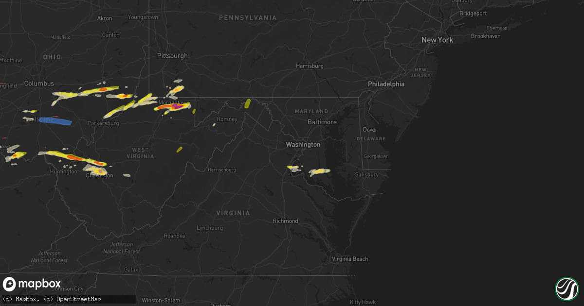
Hail Map in Maryland on June 8, 2022
Get this storm
June 8 map
$229
one time, instant access
Download today. No call, no setup
Keep the $229
Bought the map and want the full workflow? Apply the entire $229 to a subscription within 7 days. None of it is wasted.
Every map, not just this one
This buys you this map. Subscription and you get every map we run, in the markets you choose from a few cities to whole states to nationwide. Plus real-time alerts the moment a storm fires.
Contact data
Name, contact info, occupancy, even credit band for addresses in the footprint. You go from where it hit to who to call.
Become the source they trust
Unlimited branding weather history reports on demand. You already have the documented answer ready for the property owner, and you are the one who showed up with it.
Property data and RoofTrace estimates
Pull up any address you have got, its value and the exact code rules for that jurisdiction, straight from One Click Code. Then RoofTrace estimates the squares, pitch, and roof value, priced the way you price.
Storm reports in Maryland
Maryland
| Date | Description |
|---|---|
| 06/08/20226:50 PM CDT | Numerous trees blew down in columbia. A tree blew down in the 6700 block of carlinda avenue. A 12-inch tree limb blew down onto cradlerock way. A tree blew down in the |
| 06/08/20226:45 PM CDT | Tree reported down near summer cloud way. |
| 06/08/20226:43 PM CDT | Tree down on ridge road near observation drive. R exit 22. |
| 06/08/20226:43 PM CDT | Tree down on ridge road near observation drive. |
| 06/08/20226:41 PM CDT | A tree was down along diamondback and reprise drive. |
| 06/08/20226:41 PM CDT | Tree damage was reported near gaithersburg. A tree blew down near the intersection of diamondback drive and reprise drive. A tree blew down near the intersection of war |
| 06/08/20226:31 PM CDT | Report of tree down near silvan lane and church road |
| 06/08/20226:27 PM CDT | Report of downed tree near ellcott mills dr and burgess mill way |
| 06/08/20226:27 PM CDT | Tree reported down on mt. Victoria road near mill run road. |
| 06/08/20226:17 PM CDT | Tree down on hawkins creamery and laytonsville road. |
| 06/08/20226:14 PM CDT | Tree damage was reported near ironsides... Including a tree that blew down on tayloes neck road near walters landing road. |
| 06/08/20226:14 PM CDT | A tree was down along tayloes neck road and walters landing road. |
| 06/08/20226:11 PM CDT | Report of 12 inch tree limb down on roadway on cradlerock way |
| 06/08/20226:11 PM CDT | Report of tree down on 6200 block of star road |
| 06/08/20225:48 PM CDT | A tree was down along keech road and charles street. |
| 06/08/20225:45 PM CDT | Tree damage was reported near historic ellicott city. A tree blew down near the intersection of ellicott mills drive and burgess mill way. A tree blew down near the int |
| 06/08/20225:45 PM CDT | Tree damage was reported near historic ellicott city... Including a tree that blew down near the intersection of ellicott mills drive and burgess mill way. |
| 06/08/20225:41 PM CDT | Tree down near ellicott mills dr and burgess mill way |
| 06/08/20225:36 PM CDT | Tree damage was reported near nanjemoy... Including a tree that blew down in the 2200 block of sandy point road. |
| 06/08/20225:36 PM CDT | A tree was down along the 2200 block of sandy point road. |
| 06/08/20225:28 PM CDT | Report of tree down on 6700 block of carlinda ave |
| 06/08/20226:06 AM CDT | At 1106 PM EDT, severe thunderstorms were located along a line extending from Seven Springs to near Ursina to near Friendsville, moving east at 45 mph. HAZARD...60 mph wind gusts. SOURCE...Radar indicated. IMPACT...Expect damage to roofs, siding, and trees. Locations impacted include... Somerset, Meyersdale, Berlin, Friedens, Central City, Acosta, Ursina, New Centerville, Mount Davis, Rockwood, Confluence and Salisbury.This includes The Pennsylvania Turnpike from mile markers 100 to 130. |
| 06/08/20224:45 AM CDT | At 944 PM EDT, a severe thunderstorm was located 8 miles north of Kingwood, moving east at 35 mph. HAZARD...Quarter size hail. SOURCE...Radar indicated. IMPACT...Minor damage to vehicles is possible. Locations impacted include... Reedsville, Masontown, Albright, Brandonville, Bruceton Mills, Valley Point, Laurel Run, Hazelton, and Cranesville. |
| 06/08/20224:41 AM CDT | At 940 PM EDT, a severe thunderstorm was located near Brookhaven, or 7 miles northwest of Kingwood, moving east at 35 mph. HAZARD...Two inch hail and 60 mph wind gusts. SOURCE...Radar indicated. IMPACT...Expect wind damage to trees and power lines. Hail is large enough to dent and damage vehicles. Some hail damage to roofs, siding, and windows is possible. Locations impacted include... Oakland, Bittinger, Deer Park, Accident, Deep Creek Lake State Park, Swallow Falls State Park, McHenry, Jennings and McComas Beach. |
| 06/08/20224:23 AM CDT | At 923 PM EDT, a severe thunderstorm was located over Baltimore, moving northeast at 15 mph. HAZARD...60 mph wind gusts and quarter size hail. SOURCE...Radar indicated. IMPACT...Damaging winds will cause some trees and large branches to fall. This could injure those outdoors, as well as damage homes and vehicles. Roadways may become blocked by downed trees. Localized power outages are possible. Unsecured light objects may become projectiles. Locations impacted include... Baltimore, Middle River, Dundalk, Towson, Bel Air South, Essex, Parkville, Bel Air North, Carney, Perry Hall, Rosedale, Rossville, White Marsh, Fallston, Bowleys Quarters, Hampton, Kingsville, Pleasant Hills, Edgewood and Joppatowne. |
| 06/08/20224:22 AM CDT | At 922 PM EDT, a severe thunderstorm was located over Calvert Cliffs, moving east at 25 mph. HAZARD...60 mph wind gusts and quarter size hail. SOURCE...Radar indicated. IMPACT...Minor damage to vehicles is possible. Expect wind damage to trees and powerlines. This severe thunderstorm will be near... Taylors Island around 940 PM EDT.Other locations impacted by this severe thunderstorm include Madison,Taylors Island, Honga, Church Creek, Woolford and Andrews. |
| 06/08/20224:17 AM CDT | At 917 PM EDT, a severe thunderstorm was located over Ursina, moving northeast at 50 mph. HAZARD...60 mph wind gusts and nickel size hail. SOURCE...Radar indicated. IMPACT...Expect damage to roofs, siding, and trees. Locations impacted include... Somerset, Friedens, Boswell, Davidsville, Jerome, Acosta, Ursina, New Centerville, Tire Hill, Mount Davis, Rockwood and Confluence.This includes The Pennsylvania Turnpike from mile markers 100 to 114. |
| 06/08/20224:07 AM CDT | At 907 PM EDT, a severe thunderstorm was located near Saint Leonard Creek, moving east at 25 mph. HAZARD...Golf ball size hail and 60 mph wind gusts. SOURCE...Radar indicated. IMPACT...Expect wind damage to trees and power lines. Hail is large enough to dent and damage vehicles. Some hail damage to roofs, siding, and windows is possible. Locations impacted include... Chesapeake Ranch Estates, Greenwell State Park, Saint Leonard Creek, Cuckold Creek, Flag Harbor, Calvert Cliffs, Lusby, Saint Leonard, Drum Point, Long Beach, Calvert Beach, Port Republic, Dowell and Sotterley. |
| 06/08/20224:07 AM CDT | At 907 PM EDT, a severe thunderstorm was located 7 miles north of Kingwood, moving east at 30 mph. HAZARD...60 mph wind gusts and quarter size hail. SOURCE...Radar indicated. IMPACT...Minor hail damage to vehicles is possible. Expect wind damage to trees and power lines, resulting in some power outages. Locations impacted include... Kingwood, Albright, Markleysburg, Brandonville, Bruceton Mills, Valley Point, Laurel Run, Hazelton, Cranesville, and Clifton Mills. |
| 06/08/20223:17 AM CDT | At 816 PM EDT, a severe thunderstorm was located 8 miles southwest of Golden Beach, or 9 miles east of Popes Creek, moving northeast at 20 mph. HAZARD...60 mph wind gusts and quarter size hail. SOURCE...Radar indicated. IMPACT...Damaging winds will cause some trees and large branches to fall. This could injure those outdoors, as well as damage homes and vehicles. Roadways may become blocked by downed trees. Localized power outages are possible. Unsecured light objects may become projectiles. Locations impacted include... Prince Frederick, Hallowing Point, Breezy Point, Sheridan Point, Flag Harbor, Golden Beach, Saint Leonard, Huntingtown, Long Beach, Mechanicsville, Charlotte Hall, Aquasco, Calvert Beach, Benedict, Barstow, Port Republic, Sandgates and Dares Beach. |
| 06/08/20222:09 AM CDT | At 709 PM EDT, a severe thunderstorm was located over Eldersburg, or 11 miles south of Westminster, moving northeast at 25 mph. HAZARD...60 mph wind gusts and quarter size hail. SOURCE...Radar indicated. IMPACT...Damaging winds will cause some trees and large branches to fall. This could injure those outdoors, as well as damage homes and vehicles. Roadways may become blocked by downed trees. Localized power outages are possible. Unsecured light objects may become projectiles. Locations impacted include... Owings Mills, Eldersburg, Reisterstown, Hampstead, Manchester, Sykesville, Oakland, Gamber, Finksburg, Carrollton, Upperco, Louisville, Gaither, Butler, Monkton, Glencoe, Glyndon, Sparks, Boring and Patapsco. |
| 06/08/20221:58 AM CDT | At 658 PM EDT, a severe thunderstorm was located over Colesville, or near Olney, moving northeast at 15 mph. HAZARD...60 mph wind gusts and quarter size hail. SOURCE...Radar indicated. IMPACT...Damaging winds will cause some trees and large branches to fall. This could injure those outdoors, as well as damage homes and vehicles. Roadways may become blocked by downed trees. Localized power outages are possible. Unsecured light objects may become projectiles. Locations impacted include... Columbia, Olney, Elkridge, Historic Ellicott City, Ellicott City, Aspen Hill, Fairland, Colesville, Rossmoor, Savage-guilford, Wheaton-Glenmont, Scaggsville, Ilchester, Calverton, Cloverly, Glenmont, Burtonsville, Savage, Fulton and Spencerville. |
| 06/08/20221:50 AM CDT | At 650 PM EDT, a severe thunderstorm was located 7 miles east of Quantico, moving east at 15 mph. HAZARD...60 mph wind gusts and quarter size hail. SOURCE...Radar indicated. IMPACT...Damaging winds will cause some trees and large branches to fall. This could injure those outdoors, as well as damage homes and vehicles. Roadways may become blocked by downed trees. Localized power outages are possible. Unsecured light objects may become projectiles. Locations impacted include... Waldorf, La Plata, Port Tobacco River, Saint Charles, Bryans Road, Pomfret, Port Tobacco Village, Marbury, Dentsville, Port Tobacco, White Plains, Ironsides, Ripley, Rison, Bel Alton, Nanjemoy, Pisgah, Welcome and Faulkner. |
| 06/08/20221:25 AM CDT | At 624 PM EDT, a severe thunderstorm was located over Laurel, or near Beltsville, moving northeast at 25 mph. HAZARD...60 mph wind gusts and quarter size hail. SOURCE...Radar indicated. IMPACT...Damaging winds will cause some trees and large branches to fall. This could injure those outdoors, as well as damage homes and vehicles. Roadways may become blocked by downed trees. Localized power outages are possible. Unsecured light objects may become projectiles. Locations impacted include... Columbia, Severn, Elkridge, Riviera Beach, Baltimore-Washington Airport, Glen Burnie, Ellicott City, Odenton, Laurel, Pasadena, Ferndale, Brooklyn Park, Fort Meade, Savage-guilford, South Gate, Pumphrey, Scaggsville, Ilchester, Linthicum and Lansdowne. |
| 06/08/20221:16 AM CDT | At 616 PM EDT, a severe thunderstorm was located over Romney, moving northeast at 25 mph. HAZARD...60 mph wind gusts and quarter size hail. SOURCE...Radar indicated. IMPACT...Damaging winds will cause some trees and large branches to fall. This could injure those outdoors, as well as damage homes and vehicles. Roadways may become blocked by downed trees. Localized power outages are possible. Unsecured light objects may become projectiles. Locations impacted include... Romney, Fort Ashby, Springfield, Green Spring, Burlington, Russelldale, Augusta, Shanks, Three Churches, Frenchburg, Headsville, Higginsville, Slanesville, Points, Levels, Junction and Wapocomo. |
| 06/08/202212:52 AM CDT | At 552 PM EDT, a severe thunderstorm was located 9 miles southeast of Bealeton, or 13 miles northwest of Stafford, moving northeast at 10 mph. HAZARD...60 mph wind gusts and quarter size hail. SOURCE...Radar indicated. IMPACT...Damaging winds will cause some trees and large branches to fall. This could injure those outdoors, as well as damage homes and vehicles. Roadways may become blocked by downed trees. Localized power outages are possible. Unsecured light objects may become projectiles. Locations impacted include... Dale City, Quantico, Lake Ridge, Linton Hall, Montclair, Bull Run, Triangle, Dumfries, Manassas, Sudley, Cherry Hill, Independent Hill, Nokesville, Catlett, Calverton, Roseville, Garrisonville, Ramoth, Heflin and Morrisville. |
| 06/08/202212:20 AM CDT | At 520 PM EDT, a severe thunderstorm was located near Berkeley Springs, or 9 miles northeast of Paw Paw, moving north at 25 mph. HAZARD...Quarter size hail. SOURCE...Radar indicated. IMPACT...Some hail damage to agriculture is expected. Locations impacted include... Hancock, Greenwood, Berkeley Springs, Great Cacapon, Johnsons Mill, Omps, Lineburg, Valley View, Fishers Bridge, Spohrs Crossroads, Oakland, Rock Gap, Stotlers Crossroads, Highland Ridge, Forest Park, Smith Crossroads, Berryville, New Hope and Shady Grove. |
| 06/07/202210:28 PM CDT | Tree damage was reported in oakland... Including a tree that blew down on east high street. |
| 06/07/20227:49 PM CDT | Tree down on wires at the intersecion of rt. 40 and tyson rd. |
| 06/07/20227:47 PM CDT | Dozens of trees blew down and a barn was leveled east of mechanicsville. Trees blew down in the 40000 block of md-6 new market turner road near morgan brothers road. Tr |
| 06/07/20227:46 PM CDT | Tree down in 4000 block of delabrooke road. |
| 06/07/20227:45 PM CDT | Tree and large branches down at route 29 neas and large limbs down on conifer drive with gutters ripped off one house by falling tree. |
| 06/07/20227:45 PM CDT | Tree down in the 40000 block of new market road. |
| 06/07/20227:45 PM CDT | Two trees and large brances down along rt. 70 near marriotsville. |
| 06/07/20227:45 PM CDT | Tree and large branches down at route 29 near exit 22. |
| 06/07/20227:43 PM CDT | Tree reported down on three notch road near point lookout road. |
| 06/07/20227:42 PM CDT | Tree reported down on new market turner road near morgan brothers road. |
| 06/07/20227:40 PM CDT | Tree reported down on baptist church road near emmart lane. |
| 06/07/20227:40 PM CDT | Tree damage was reported between elkridge and columbia... Including a tree that blew down off of summer cloud way. |
| 06/07/20227:38 PM CDT | Tree reported down on sandchain road near cobbler ct. |
| 06/07/20227:38 PM CDT | Dozens of trees blew down near mechanicsville. Trees blew down near the intersection of mechanicsville road and guy farm road. Trees blew down in the 16800 block of bap |
| 06/07/20227:36 PM CDT | Tree reported down on the 28700 block of lockes hill road. |
| 06/07/20227:32 PM CDT | Tree down on the 16800 block of baptist church road. Time determined by radar. |
| 06/07/20227:27 PM CDT | Trees down on mechanicsville road near guy farm road. |
| 06/07/20227:15 PM CDT | Two trees and large tree limbs blew down along i-70 near marriotsville. |
| 06/07/20227:08 PM CDT | Tree down near warfield and dorsey road. |
| 06/07/20227:01 PM CDT | Report of downed tree on a residence |
| 06/07/20227:01 PM CDT | Report of downed tree and multiple large trees limbs |
| 06/07/20227:00 PM CDT | Tree damage was reported between laytsonville and germantown. A tree blew down near the intersection of hawkins creamery road and md-108 laytonsville road. A tree blew |
All States Impacted by Hail Map on June 8, 2022
Cities Impacted by Hail Map on June 8, 2022
- Chouteau, OK
- Elizabethtown, IN
- Seymour, IN
- Butlerville, IN
- Versailles, IN
- Osgood, IN
- Scipio, IN
- Jonesville, IN
- Holton, IN
- Brownstown, IN
- Westport, IN
- Columbus, IN
- Greensburg, IN
- North Vernon, IN
- Madison, IN
- Sarahsville, OH
- Woodsfield, OH
- Beallsville, OH
- Summerfield, OH
- Caldwell, OH
- Lewisville, OH
- Clarington, OH
- Graysville, OH
- Carmichaels, PA
- Jefferson, PA
- Portsmouth, OH
- White Cottage, OH
- Zanesville, OH
- Roseville, OH
- Mooresville, IN
- Oxford, NC
- Proctor, WV
- Waynesburg, PA
- Patriot, OH
- Seagrove, NC
- Holdenville, OK
- Sweetwater, OK
- Lesage, WV
- Maysville, OK
- Pauls Valley, OK
- Lindsay, OK
- Lexington, OK
- Ridgeville, SC
- Summerville, SC
- Searcy, AR
- Augusta, AR
- Coweta, OK
- Porter, OK
- Locust Grove, OK
- Dix, IL
- Mount Vernon, IL
- Red House, WV
- Charleston, WV
- Poca, WV
- Liberty, WV
- Spruce Pine, AL
- Hodges, AL
- Phil Campbell, AL
- Russellville, AL
- Vina, AL
- Red Bay, AL
- Groom, TX
- Poyen, AR
- Malvern, AR
- Beaverton, AL
- Blanchard, OK
- Tuttle, OK
- Norman, OK
- Newcastle, OK
- Amber, OK
- Truth Or Consequences, NM
- Stonewall, OK
- Fitzhugh, OK
- Macomb, OK
- Dierks, AR
- Masontown, PA
- Uniontown, PA
- McClellandtown, PA
- Smithfield, PA
- Greensboro, PA
- Welling, OK
- Sulligent, AL
- Sterrett, AL
- Harpersville, AL
- Clarksburg, OH
- Alamogordo, NM
- Cloudcroft, NM
- Foster, KY
- Brooksville, KY
- Dunnellon, FL
- Pinson, AL
- Birmingham, AL
- Trussville, AL
- Tremont, MS
- Smithville, MS
- Hamilton, AL
- Fulton, MS
- Detroit, AL
- Greenwood Springs, MS
- Fort Stockton, TX
- El Dorado, AR
- Ripley, OH
- Winchester, OH
- Russellville, OH
- Manchester, OH
- West Union, OH
- Peebles, OH
- Sentinel, OK
- Dill City, OK
- Port Republic, MD
- Newburg, MD
- Charlotte Hall, MD
- Prince Frederick, MD
- Lusby, MD
- Saint Leonard, MD
- Mechanicsville, MD
- Hollywood, MD
- Broomes Island, MD
- Asher, OK
- Konawa, OK
- Purcell, OK
- Beverly Hills, FL
- Hernando, FL
- Charleston, AR
- Point Marion, PA
- Martin, PA
- Bobtown, PA
- Nemacolin, PA
- Morgantown, WV
- Dilliner, PA
- Maidsville, WV
- Adah, PA
- New Salem, PA
- Ronco, PA
- Garards Fort, PA
- Mount Morris, PA
- Uledi, PA
- Lamar, OK
- Mcalester, OK
- Burlington, WV
- New Creek, WV
- Batesville, IN
- Currituck, NC
- Moyock, NC
- Quinton, OK
- Stigler, OK
- Brownsville, PA
- Allison, PA
- Denbo, PA
- Hiller, PA
- East Millsboro, PA
- Merrittstown, PA
- Vanderbilt, PA
- Grindstone, PA
- Smock, PA
- Maud, OK
- Balmorhea, TX
- Erick, OK
- Van Horn, TX
- Park Hill, OK
- Tahlequah, OK
- Dyer, AR
- Van Buren, AR
- Lavaca, AR
- Fort Smith, AR
- Alma, AR
- Greenwood, AR
- Fairview, WV
- Rivesville, WV
- Farmington, WV
- Fairmont, WV
- Lexington, KY
- Sparkman, AR
- Pampa, TX
- Cambridge, OH
- Bretz, WV
- Masontown, WV
- Independence, WV
- Montana Mines, WV
- Mannington, WV
- Kingwood, WV
- Bruceton Mills, WV
- Reedsville, WV
- Albright, WV
- Rachel, WV
- Baxter, WV
- Sayre, OK
- Rocky, OK
- Hobart, OK
- Amberg, WI
- Pembine, WI
- Littleton, WV
- New Martinsville, WV
- Rayville, LA
- Oviedo, FL
- Wynnewood, OK
- Palatka, FL
- Green Cove Springs, FL
- Georgetown, OH
- Bethel, OH
- Hamersville, OH
- Branch, AR
- Winter Park, FL
- Winter Springs, FL
- Casselberry, FL
- Maitland, FL
- Sanford, FL
- Stafford, VA
- Quantico, VA
- Nanjemoy, MD
- Indian Head, MD
- Tularosa, NM
- Carnegie, OK
- Anadarko, OK
- Binger, OK
- Gracemont, OK
- Corn, OK
- Lookeba, OK
- Bessie, OK
- Clinton, OK
- Pocasset, OK
- Arapaho, OK
- Weatherford, OK
- Hydro, OK
- Cordell, OK
- Fort Cobb, OK
- Minco, OK
- Chickasha, OK
- Colony, OK
- Foss, OK
- Dumas, MS
- New Albany, MS
- Ripley, MS
- Blue Mountain, MS
- Somerset, OH
- Junction City, OH
- Cement, OK
- Bixby, OK
- Broken Arrow, OK
- Marlow, OK
- Elgin, OK
- Rush Springs, OK
- Ninnekah, OK
- Bradley, OK
- Fletcher, OK
- Inola, OK
- Tulsa, OK
- Sand Springs, OK
- Cullman, AL
- Hanceville, AL
- Hopkins, SC
- Columbia, SC
- Eastover, SC
- Abbeville, SC
- Haskell, OK
- Dupont, IN
- Mcconnelsville, OH
- Cumberland, OH
- Gallipolis, OH
- Vinson, OK
- Hollis, OK
- Eufaula, OK
- Woodlawn, IL
- Bunch, OK
- Dardanelle, AR
- London, AR
- Delaware, AR
- Russellville, AR
- Danville, AR
- Atkins, AR
- Pottsville, AR
- Byesville, OH
- Kipling, OH
- Senecaville, OH
- Lynx, OH
- Vanceburg, KY
- Stout, OH
- Aberdeen, OH
- Maysville, KY
- Proctorville, OH
- Nichols, SC
- New Matamoras, OH
- Reno, OH
- Williamstown, WV
- Whipple, OH
- Marietta, OH
- Newport, OH
- Verden, OK
- Geary, OK
- Hinton, OK
- Cleveland, OK
- Hominy, OK
- Prue, OK
- Osage, OK
- Inverness, FL
- Lancaster, OH
- Fort Sill, OK
- Bamberg, SC
- Healdton, OK
- Logan, AL
- Crane Hill, AL
- Tollesboro, KY
- Amanda, OH
- Quaker City, OH
- Pleasant City, OH
- Chandlersville, OH
- Pleasantville, OH
- Rushville, OH
- Philo, OH
- Carroll, OH
- Baltimore, OH
- New Lexington, OH
- Bremen, OH
- Crooksville, OH
- Blue Rock, OH
- Barnesville, OH
- Wellington, TX
- La Plata, MD
- Perryville, AR
- Paron, AR
- Plainview, AR
- Casa, AR
- Ola, AR
- Saint Cloud, FL
- Blountsville, AL
- Elkview, WV
- Clendenin, WV
- Augusta, KY
- Falmouth, KY
- Ratcliff, AR
- Nauvoo, AL
- Carbon Hill, AL
- White Sands Missile Range, NM
- Eastaboga, AL
- El Paso, TX
- Townley, AL
- Orrum, NC
- Latonia, KY
- Aurora, IN
- Florence, KY
- Rising Sun, IN
- Petersburg, KY
- Newport, KY
- Ft Mitchell, KY
- Union, KY
- Independence, KY
- Walton, KY
- Burlington, KY
- Cameron, WV
- Vienna, WV
- Pine Grove, WV
- Hundred, WV
- Paden City, WV
- Burton, WV
- Reader, WV
- New Freeport, PA
- Metz, WV
- Friendly, WV
- Middlebourne, WV
- Porters Falls, WV
- Wana, WV
- Aleppo, PA
- Sardis, OH
- Sistersville, WV
- Kenna, WV
- Buffalo, WV
- Paris, KY
- San Ysidro, NM
- Jemez Pueblo, NM
- Mayesville, SC
- Bishopville, SC
- Little Rock, AR
- Weleetka, OK
- Okemah, OK
- Sierra Blanca, TX
- Evergreen, NC
- Fort Davis, TX
- Benton, AR
- Alexander, AR
- Bryant, AR
- Davis, OK
- Sulphur, OK
- Vernon, AL
- Frankfort, OH
- Chillicothe, OH
- Greenfield, OH
- South Salem, OH
- Wewoka, OK
- Welcome, MD
- Mount Pleasant, TN
- Columbia, TN
- Belleville, AR
- Claude, TX
- Baileyton, AL
- Eva, AL
- Owasso, OK
- Catoosa, OK
- Dunbar, WV
- Hurricane, WV
- Scott Depot, WV
- Saint Albans, WV
- Winfield, WV
- Nitro, WV
- Hope, IN
- New Concord, OH
- Washington Court House, OH
- Galax, VA
- Fair Bluff, NC
- Houston, AL
- Addison, AL
- Walters, OK
- Faxon, OK
- Salt Flat, TX
- Dell City, TX
- Vincent, AL
- Mclean, TX
- Peggs, OK
- Rose, OK
- Salina, OK
- Pryor, OK
- Hartsville, IN
- Havana, AR
- Roxboro, NC
- Wheelersburg, OH
- Port Tobacco, MD
- Melbourne, KY
- California, KY
- Moscow, OH
- Butler, KY
- Alexandria, KY
- New Richmond, OH
- Felicity, OH
- Noble, OK
- Fraziers Bottom, WV
- Waterloo, OH
- South Shore, KY
- Willow Wood, OH
- Franklin Furnace, OH
- Glenwood, WV
- Pedro, OH
- Leon, WV
- South Portsmouth, KY
- Apple Grove, WV
- Crown City, OH
- Scottown, OH
- Ashton, WV
- South Webster, OH
- Kitts Hill, OH
- Chesapeake, OH
- Grafton, WV
- Bethesda, OH
- Belmont, OH
- Bickmore, WV
- Swiss, WV
- Clay, WV
- Summersville, WV
- Monrovia, IN
- Martinsville, IN
- Calhoun, GA
- Ona, WV
- South Charleston, WV
- Eleanor, WV
- Chaparral, NM
- Benoit, MS
- Hayden, AL
- Camden, SC
- Nobleton, FL
- Bushnell, FL
- Brooksville, FL
- Okeechobee, FL
- Eldridge, AL
- Nettleton, MS
- Okolona, MS
- Fort Hancock, TX
- Advent, WV
- De Queen, AR
- Nashoba, OK
- Waurika, OK
- Pioneer, LA
- Oak Grove, LA
- Mer Rouge, LA
- Lake Providence, LA
- Fairbank, PA
- Rices Landing, PA
- Crucible, PA
- New Geneva, PA
- Bear Creek, AL
- Woodstock, AL
- Vance, AL
- Hackleburg, AL
- Paoli, OK
- Arthurdale, WV
- Jerusalem, OH
- Floral City, FL
- Mullins, SC
- Blue Creek, OH
- Erlanger, KY
- Gallipolis Ferry, WV
- Southside, WV
- Williamsport, OH
- Wingett Run, OH
- Cameron, OH
- Woodlawn, VA
- Hancock, MD
- Berkeley Springs, WV
- Great Cacapon, WV
- Beverly, WV
- Glady, WV
- Terra Alta, WV
- Laguna, NM
- Cimarron, NM
- Mountain View, OK
- Willow, OK
- Mangum, OK
- Chattanooga, OK
- Lone Wolf, OK
- Burkburnett, TX
- Snyder, OK
- Oklaunion, TX
- Butler, OK
- Frederick, OK
- Iowa Park, TX
- Headrick, OK
- Electra, TX
- Cache, OK
- Gotebo, OK
- Canute, OK
- Harrold, TX
- Devol, OK
- Geronimo, OK
- Blair, OK
- Davidson, OK
- Holliday, TX
- Hollister, OK
- Roosevelt, OK
- Seymour, TX
- Loveland, OK
- Indiahoma, OK
- Mountain Park, OK
- Tipton, OK
- Elk City, OK
- Randlett, OK
- Grandfield, OK
- Vernon, TX
- Wichita Falls, TX
- Granite, OK
- Sheppard Afb, TX
- Carter, OK
- Lawton, OK
- Wagoner, OK
- Hulbert, OK
- Cookson, OK
- Muldrow, OK
- Fort Gibson, OK
- Stilwell, OK
- Uniontown, AR
- Calvin, OK
- Wetumka, OK
- Stuart, OK
- Allen, OK
- Atwood, OK
- Roland, AR
- Bigelow, AR
- Hollandale, MS
- Cleveland, MS
- Itta Bena, MS
- Isola, MS
- Greenville, MS
- Dermott, AR
- Grady, AR
- Wilmar, AR
- Moorhead, MS
- Star City, AR
- Shaw, MS
- Belzoni, MS
- Indianola, MS
- Boyle, MS
- Monticello, AR
- Arkansas City, AR
- Leland, MS
- Warren, AR
- Inverness, MS
- Rison, AR
- Dumas, AR
- Beulah, MS
- Tillar, AR
- McGehee, AR
- Rohwer, AR
- Vardaman, MS
- Grenada, MS
- Woodland, MS
- Gore Springs, MS
- Houston, MS
- Calhoun City, MS
- Duck Hill, MS
- Mantee, MS
- Rushville, IN
- Arlington, IN
- Arcanum, OH
- Troy, OH
- Tipp City, OH
- West Milton, OH
- Casstown, OH
- Springfield, OH
- Sardinia, OH
- South Bloomingville, OH
- Union City, IN
- Albany, IN
- Winchester, IN
- Farmland, IN
- Eaton, IN
- Parker City, IN
- Ridgeville, IN
- Muncie, IN
- Saratoga, IN
- Gaston, IN
- Milan, IN
- Dillsboro, IN
- Stilesville, IN
- Camby, IN
- Bargersville, IN
- Brooklyn, IN
- Greenwood, IN
- Ada, OK
- Stratford, OK
- Zaleski, OH
- Ray, OH
- Albany, OH
- New Plymouth, OH
- Athens, OH
- Creola, OH
- New Marshfield, OH
- McArthur, OH
- Londonderry, OH
- Hebron, KY
- Sharpsburg, GA
- Newnan, GA
- Carrollton, GA
- Franklin, GA
- Turkey, TX
- Flomot, TX
- Gould, OK
- Roaring Springs, TX
- Tulia, TX
- Quanah, TX
- Kress, TX
- Lockney, TX
- Wayside, TX
- Amarillo, TX
- Crosbyton, TX
- Plainview, TX
- Memphis, TX
- Ralls, TX
- Quitaque, TX
- Shamrock, TX
- Floydada, TX
- Happy, TX
- Clarendon, TX
- Dickens, TX
- Spur, TX
- Dodson, TX
- Paducah, TX
- Childress, TX
- Matador, TX
- Hedley, TX
- Mcadoo, TX
- Silverton, TX
- Lakeview, TX
- Lelia Lake, TX
- Afton, TX
- Wheeler, TX
- Canyon, TX
- Quail, TX


