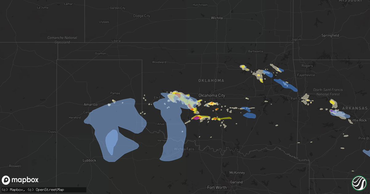
Hail Map in Oklahoma on June 8, 2022
Get this storm
June 8 map
$229
one time, instant access
Download today. No call, no setup
Keep the $229
Bought the map and want the full workflow? Apply the entire $229 to a subscription within 7 days. None of it is wasted.
Every map, not just this one
This buys you this map. Subscription and you get every map we run, in the markets you choose from a few cities to whole states to nationwide. Plus real-time alerts the moment a storm fires.
Contact data
Name, contact info, occupancy, even credit band for addresses in the footprint. You go from where it hit to who to call.
Become the source they trust
Unlimited branding weather history reports on demand. You already have the documented answer ready for the property owner, and you are the one who showed up with it.
Property data and RoofTrace estimates
Pull up any address you have got, its value and the exact code rules for that jurisdiction, straight from One Click Code. Then RoofTrace estimates the squares, pitch, and roof value, priced the way you price.
Storm reports in Oklahoma
Oklahoma
| Date | Description |
|---|---|
| 06/08/202211:41 AM CDT | Report of power lines and trees down in locust grove. |
| 06/08/202211:40 AM CDT | Large trees down. |
| 06/08/202211:27 AM CDT | Emergency manager reported a couple of power poles downed by thunderstorm winds on oakwood road. |
| 06/08/202211:03 AM CDT | Tree down on car. |
| 06/08/202210:45 AM CDT | Large tree limbs down; time estimated by radar. |
| 06/08/202210:45 AM CDT | A local report indicates 60 MPH wind near 3 ESE HOLDENVILLE |
| 06/08/20229:35 AM CDT | A local report indicates 58 MPH wind near 4 NW WALTERS |
| 06/08/20229:32 AM CDT | Spotter measured 63 mph thunderstorm wind gust ese of hulbert. Multiple tree limbs... 1 to 2 inches in diameter damaged or broken. |
| 06/08/20229:19 AM CDT | Social media report of ping pong ball sized hail just northeast of sterling. |
| 06/08/20229:13 AM CDT | Report from mping: 1-inch tree limbs broken; shingles blown off. |
| 06/08/20228:59 AM CDT | Rfd winds in cold portion of storm after 12 degree of temperature change. |
| 06/08/20228:59 AM CDT | Report from mping: trees uprooted or snapped; roof blown off. |
| 06/08/20228:57 AM CDT | Report from mping: 3-inch tree limbs broken; power poles broken. |
| 06/08/20228:55 AM CDT | A local report indicates 62 MPH wind near 3 NW CHICKASHA |
| 06/08/20228:52 AM CDT | Off duty nws employee reports golf ball sized hail in nw norman. |
| 06/08/20228:50 AM CDT | Meassured 58 mph wind gust. |
| 06/08/20228:50 AM CDT | A local report indicates 60 MPH wind near 4 S TIPTON |
| 06/08/20228:48 AM CDT | Report from mping: half dollar |
| 06/08/20228:47 AM CDT | Report from mping: quarter |
| 06/08/20228:47 AM CDT | Report from mping: ping pong ball |
| 06/08/20228:30 AM CDT | A local report indicates 60 MPH wind near 3 S ALTUS |
| 06/08/20228:30 AM CDT | A local report indicates 2.50 inch wind near 1 W ACME |
| 06/08/20228:21 AM CDT | Social media report of golf ball sized hail just west of rush springs. |
| 06/08/20228:20 AM CDT | Social media report of 1 hail in rush springs. |
| 06/08/20228:20 AM CDT | Golf ball sized hail reported just north of anadarko. |
| 06/08/20228:15 AM CDT | A local report indicates 65 MPH wind near 3 W GOULD |
| 06/08/20228:00 AM CDT | A local report indicates 58 MPH wind near FORT COBB |
| 06/08/20228:00 AM CDT | A local report indicates 58 MPH wind near 4 NNW FORT COBB |
| 06/08/20227:59 AM CDT | Broadcast media relayed chaser report of measured thunderstorm wind gust of 59 mph and nickel hail between prue and osage. |
| 06/08/20227:50 AM CDT | Wind driven hail damage to house. This includes siding... Shingles and fence. |
| 06/08/20227:29 AM CDT | A local report indicates 1.00 inch wind near WEATHERFORD |
| 06/08/20227:29 AM CDT | Report from mping: quarter |
| 06/08/20227:15 AM CDT | A local report indicates 60 MPH wind near 4 WSW WEATHERFORD |
| 06/08/20227:10 AM CDT | A local report indicates 72 MPH wind near 4 WNW BESSIE |
| 06/08/20227:04 AM CDT | A local report indicates 1.75 inch wind near 3 SW CLINTON |
| 06/08/20227:04 AM CDT | A local report indicates 75 MPH wind near 3 SW CLINTON |
| 06/08/20226:48 AM CDT | At 1148 AM CDT, a severe thunderstorm was located over Rose, moving east at 40 mph. HAZARD...60 mph wind gusts and quarter size hail. SOURCE...Radar indicated. IMPACT...Hail damage to vehicles is expected. Expect wind damage to roofs, siding, and trees. Locations in or near the path include... Locust Grove... West Siloam Springs... Kansas... Oaks... Leach... Scraper... Twin Oaks... Rose... Natural Falls State Park... |
| 06/08/20225:59 AM CDT | At 1058 AM CDT, severe thunderstorms were located along a line extending from 6 miles south of Dustin to 6 miles southwest of Scipio, moving east at 45 mph. HAZARD...60 mph wind gusts and quarter size hail. SOURCE...Radar indicated. IMPACT...Hail damage to vehicles is expected. Expect wind damage to roofs, siding, and trees. Locations in or near the path include... Crowder... Canadian... Indianola... Hanna... Arrowhead State Park... Raiford... Scipio... Vivian... Vernon... |
| 06/08/20225:56 AM CDT | At 1055 AM CDT, a severe thunderstorm was located near Horntown, moving east at 25 mph. HAZARD...60 mph wind gusts. SOURCE...The Holdenville Mesonet measured a 60 mph wind gust. IMPACT...Expect damage to roofs, siding, and trees. Locations impacted include... Calvin, Lamar and Horntown. |
| 06/08/20225:06 AM CDT | At 1006 AM CDT, severe thunderstorms were located along a line extending from 3 miles northwest of Tecumseh to 6 miles northeast of Konawa to 4 miles west of Byng, moving east at 20 mph. HAZARD...60 mph wind gusts. SOURCE...Radar indicated. IMPACT...Expect damage to roofs, siding, and trees. Locations impacted include... Shawnee, Seminole, Tecumseh, Holdenville, Wewoka, Pink, Konawa, Byng, Maud, Allen, Earlsboro, Bowlegs, Asher, Tribbey, Wanette, Francis, Byars, St. Louis, Sasakwa and Atwood. |
| 06/08/20225:04 AM CDT | At 1003 AM CDT, severe thunderstorms were located along a line extending from 6 miles southwest of Ryan to 8 miles west of Westover, moving southeast at 35 mph. HAZARD...70 mph wind gusts. SOURCE...Trained weather spotters reported a 68 mph wind gust southwest of Wichita Falls. IMPACT...Expect considerable tree damage. Damage is likely to mobile homes, roofs, and outbuildings. Locations impacted include... Wichita Falls, Henrietta, Seymour, Archer City, Holliday, Petrolia, Scotland, Byers, Dean, Windthorst, Bellevue, Megargel, Jolly, Westover, Bluegrove, Bomarton, Mabelle, Mankins, Lake Arrowhead and Sheppard AFB. |
| 06/08/20224:43 AM CDT | At 943 AM CDT, severe thunderstorms were located along a line extending from 6 miles northwest of Tahlequah to 8 miles northwest of Cherokee Landing State Park to 2 miles north of Pumpkin Center, moving southeast at 40 mph. HAZARD...60 mph wind gusts and penny size hail. SOURCE...Radar indicated. IMPACT...Expect damage to roofs, siding, and trees. Locations in or near the path include... Tahlequah... Stilwell... Cookson... Eldon... Proctor... Cherokee Landing State Park... Bunch... Maryetta... |
| 06/08/20224:19 AM CDT | At 919 AM CDT, severe thunderstorms were located along a line extending from 4 miles southeast of Paoli to near Foster to 5 miles southeast of Bray, moving southeast at 25 mph. HAZARD...Ping pong ball size hail and 60 mph wind gusts. SOURCE...Radar indicated. IMPACT...People and animals outdoors will be injured. Expect hail damage to roofs, siding, windows, and vehicles. Expect wind damage to roofs, siding, and trees. Locations impacted include... Pauls Valley, Lindsay, Wynnewood, Maysville, Bray, Elmore City, Paoli, Katie, Foster, Antioch, Hennepin, Pernell, Cox City, Whitebead and Erin Springs. |
| 06/08/20224:15 AM CDT | At 915 AM CDT, severe thunderstorms were located along a line extending from 5 miles east of Inola to 10 miles south of Chouteau to near Wagoner to 2 miles south of Porter, moving east at 40 mph. HAZARD...60 mph wind gusts and penny size hail. SOURCE...Radar indicated. IMPACT...Expect damage to roofs, siding, and trees. Locations in or near the path include... Muskogee... Tahlequah... Wagoner... Fort Gibson... Okay... Hulbert... Porter... Tullahassee... Peggs... Sequoyah State Park... Redbird... Mazie... Lost City... Murphy... |
| 06/08/20224:02 AM CDT | At 902 AM CDT, a severe thunderstorm was located near Inola, moving southeast at 20 mph. HAZARD...70 mph wind gusts. SOURCE...Radar indicated. IMPACT...Expect considerable tree damage. Damage is likely to mobile homes, roofs, and outbuildings. Locations in or near the path include... Inola... Mazie... |
| 06/08/20223:58 AM CDT | At 858 AM CDT, severe thunderstorms were located along a line extending from 4 miles southwest of Agawam to 4 miles west of Goldsby, moving southeast at 30 mph. HAZARD...Golf ball size hail and 60 mph wind gusts. SOURCE...Radar indicated. IMPACT...People and animals outdoors will be injured. Expect hail damage to roofs, siding, windows, and vehicles. Expect wind damage to roofs, siding, and trees. Locations impacted include... Southern Oklahoma City, Norman, Moore, Duncan, Chickasha, Newcastle, Blanchard, Purcell, Marlow, Noble, Tuttle, Slaughterville, Lindsay, Lexington, Goldsby, Maysville, Rush Springs, Bray, Dibble and Wayne. |
| 06/08/20223:50 AM CDT | At 850 AM CDT, a severe thunderstorm was located 6 miles southwest of Bradley, moving northeast at 20 mph. HAZARD...Ping pong ball size hail and 60 mph wind gusts. SOURCE...Radar indicated. IMPACT...People and animals outdoors will be injured. Expect hail damage to roofs, siding, windows, and vehicles. Expect wind damage to roofs, siding, and trees. Locations impacted include... Lindsay, Dibble, Cole, Alex, Bradley, Criner, Cox City, Erin Springs and Payne. |
| 06/08/20223:44 AM CDT | At 844 AM CDT, severe thunderstorms were located along a line extending from 6 miles southwest of Hollis to 5 miles east of South Plains, moving southeast at 65 mph. HAZARD...70 mph wind gusts. SOURCE...Radar indicated. IMPACT...Expect considerable tree damage. Damage is likely to mobile homes, roofs, and outbuildings. Locations impacted include... Childress, Memphis, Turkey, Caprock Canyon State Park, Quitaque, Cee Vee, South Plains, Kirkland, Brice, Swearingen, Valley Schools, Flomot, Tell, Northfield, Estelline, Lakeview and Plaska Community. |
| 06/08/20223:31 AM CDT | At 830 AM CDT, a severe thunderstorm was located near Newcastle, moving northeast at 15 mph. HAZARD...60 mph wind gusts and quarter size hail. SOURCE...Radar indicated. IMPACT...Hail damage to vehicles is expected. Expect wind damage to roofs, siding, and trees. Locations impacted include... Southern Oklahoma City, Norman, Moore, Newcastle, Blanchard, Tuttle, Goldsby, Valley Brook, Bridge Creek, Stanley Draper Lake, Tinker Air Force Base and western Lake Thunderbird. |
| 06/08/20223:13 AM CDT | At 813 AM CDT, severe thunderstorms were located along a line extending from 6 miles north of Cogar to 4 miles east of Gracemont to 6 miles southwest of Fort Cobb, moving southeast at 35 mph. HAZARD...Ping pong ball size hail and 60 mph wind gusts. SOURCE...Radar indicated. IMPACT...People and animals outdoors will be injured. Expect hail damage to roofs, siding, windows, and vehicles. Expect wind damage to roofs, siding, and trees. Locations impacted include... Southwestern Oklahoma City, El Reno, Chickasha, Blanchard, Anadarko, Mustang, Tuttle, Carnegie, Union City, Minco, Cyril, Binger, Fort Cobb, Alex, Verden, Cement, Amber, Bridge Creek, Gracemont and Pocasset. |
| 06/08/20223:04 AM CDT | At 804 AM CDT, a severe thunderstorm was located 4 miles northeast of Sterling, moving east at 35 mph. HAZARD...Ping pong ball size hail and 60 mph wind gusts. SOURCE...Radar indicated. IMPACT...People and animals outdoors will be injured. Expect hail damage to roofs, siding, windows, and vehicles. Expect wind damage to roofs, siding, and trees. Locations impacted include... Chickasha, Rush Springs, Fletcher, Cyril, Sterling, Alex, Cement, Norge, Bradley, Agawam, Tabler, Ninnekah and Acme. |
| 06/08/20222:53 AM CDT | At 753 AM CDT, severe thunderstorms were located along a line extending from 7 miles southwest of Memphis to near Dodson, moving south at 80 mph. HAZARD...70 mph wind gusts. SOURCE...Radar indicated. IMPACT...Expect considerable tree damage. Damage is likely to mobile homes, roofs, and outbuildings. Locations impacted include... Childress, Memphis, Cee Vee, Tell, Kirkland, Swearingen and Estelline. |
| 06/08/20222:44 AM CDT | At 744 AM CDT, a severe thunderstorm was located over Osage, moving southeast at 25 mph. HAZARD...60 mph wind gusts and quarter size hail. SOURCE...Radar indicated. IMPACT...Hail damage to vehicles is expected. Expect wind damage to roofs, siding, and trees. Locations in or near the path include... Tulsa... Sand Springs... Cleveland... Mannford... Westport... Osage... Keystone State Park... Walnut Creek State Park... |
| 06/08/20222:42 AM CDT | At 742 AM CDT, severe thunderstorms were located along a line extending from 8 miles northwest of Vinson to 7 miles northeast of Lelia Lake to 11 miles west of Brice, moving east at 45 mph. HAZARD...70 mph wind gusts. SOURCE...Radar indicated. IMPACT...Expect some tree damage. Damage is likely to mobile homes, roofs, and outbuildings. Locations impacted include... Wellington, Clarendon, Shamrock, Mclean, Howardwick, Hedley, Dodson, Lutie, Lelia Lake, Lake Mcclellan, Lela, Samnorwood, Quail, Dozier, Alanreed and Greenbelt Lake. |
| 06/08/20222:41 AM CDT | At 740 AM CDT, severe thunderstorms were located along a line extending from near Hinton to near Eakly to 5 miles southeast of Cloud Chief, moving east at 30 mph. HAZARD...Golf ball size hail and 70 mph wind gusts. SOURCE...Radar indicated. IMPACT...People and animals outdoors will be injured. Expect hail damage to roofs, siding, windows, and vehicles. Expect considerable tree damage. Wind damage is also likely to mobile homes, roofs, and outbuildings. Locations impacted include... El Reno, Hinton, Carnegie, Union City, Minco, Mountain View, Binger, Fort Cobb, Eakly, Gracemont, Lookeba, Cogar, Alfalfa, Fort Cobb Reservoir, Albert, Lake Chickasha, Cedar Lake and Cowden. |
| 06/08/20222:27 AM CDT | At 727 AM CDT, severe thunderstorms were located along a line extending from near Dill City to 9 miles southwest of Erick, moving southeast at 40 mph. HAZARD...60 mph wind gusts and quarter size hail. SOURCE...Radar indicated. IMPACT...Hail damage to vehicles is expected. Expect wind damage to roofs, siding, and trees. Locations impacted include... Elk City, Sayre, Hobart, Mangum, Cordell, Hollis, Granite, Burns Flat, Erick, Sentinel, Dill City, Canute, Lone Wolf, Carter, Gotebo, Rocky, Foss, Willow, Texola and Retrop. |
| 06/08/20222:10 AM CDT | At 709 AM CDT, severe thunderstorms were located along a line extending from 4 miles north of Weatherford to 4 miles north of Corn to near Cordell, moving southeast at 25 mph. HAZARD...Golf ball size hail and 70 mph wind gusts. SOURCE...Trained weather spotters reported golf ball size hail and estimated 75 mph winds southwest of Clinton. IMPACT...People and animals outdoors will be injured. Expect hail damage to roofs, siding, windows, and vehicles. Expect considerable tree damage. Wind damage is also likely to mobile homes, roofs, and outbuildings. Locations impacted include... Weatherford, Cordell, Hinton, Burns Flat, Hydro, Corn, Eakly, Bessie, Lookeba, Colony, Bridgeport, Alfalfa, Cloud Chief, Fort Cobb Reservoir and Cowden. |
| 06/08/20221:59 AM CDT | At 659 AM CDT, severe thunderstorms were located along a line extending from 3 miles east of Allison to Pampa to 10 miles south of Fritch, moving east at 55 mph. HAZARD...70 mph wind gusts. SOURCE...Radar indicated. IMPACT...Expect some tree damage. Damage is likely to mobile homes, roofs, and outbuildings. Locations impacted include... Pampa, Borger, Miami, Fritch, Briscoe, White Deer, Skellytown, Sanford, New Mobeetie, Allison, Lora, Kingsmill, Codman and Mobeetie. |
| 06/08/20221:49 AM CDT | At 649 AM CDT, severe thunderstorms were located along a line extending from 5 miles east of Clinton to 3 miles northwest of Canute to 7 miles southwest of Hammon to 9 miles north of Sayre to 3 miles north of Sweetwater, moving southeast at 20 mph. HAZARD...Golf ball size hail and 60 mph wind gusts. SOURCE...Radar indicated. IMPACT...People and animals outdoors will be injured. Expect hail damage to roofs, siding, windows, and vehicles. Expect wind damage to roofs, siding, and trees. Locations impacted include... Elk City, Weatherford, Clinton, Sayre, Cordell, Burns Flat, Arapaho, Dill City, Canute, Corn, Custer City, Butler, Bessie, Foss, Colony, Sweetwater, Foss Reservoir, Berlin, Stafford and Dempsey. |
| 06/08/20221:36 AM CDT | At 636 AM CDT, severe thunderstorms were located along a line extending from 7 miles north of Sweetwater to 5 miles north of Lefors to 7 miles west of Panhandle to 8 miles northeast of Bushland, moving southeast at 55 mph. HAZARD...70 mph wind gusts and quarter size hail. SOURCE...Radar indicated. IMPACT...Expect some tree damage. Damage is likely to mobile homes, roofs, and outbuildings. Hail damage to vehicles is expected. Locations impacted include... Amarillo, Canyon, Panhandle, Wellington, Clarendon, Shamrock, Claude, Wheeler, White Deer, Lake Tanglewood, Mclean, Groom, Lefors, Howardwick, Hedley, Dodson, Bushland, Buffalo Lake, Lelia Lake and Lake Mcclellan. |
| 06/08/20221:26 AM CDT | At 626 AM CDT, severe thunderstorms were located along a line extending from 6 miles north of Lake Meredith to 4 miles north of Lora to 6 miles west of Durham, moving east at 40 mph. HAZARD...70 mph wind gusts and quarter size hail. SOURCE...Radar indicated. IMPACT...Expect some tree damage. Damage is likely to mobile homes, roofs, and outbuildings. Hail damage to vehicles is expected. Locations impacted include... Borger, Canadian, Miami, Fritch, Sunray, Stinnett, Sanford, Lora, Glazier, Lake Marvin, Lake Meredith and Pringle. |
| 06/08/20221:22 AM CDT | At 622 AM CDT, severe thunderstorms were located along a line extending from 4 miles southeast of Butler to 5 miles southwest of Hammon to near Strong City to 6 miles southeast of Reydon, moving southeast at 25 mph. HAZARD...Golf ball size hail and 70 mph wind gusts. SOURCE...Radar indicated. IMPACT...People and animals outdoors will be injured. Expect hail damage to roofs, siding, windows, and vehicles. Expect considerable tree damage. Wind damage is also likely to mobile homes, roofs, and outbuildings. Locations impacted include... Elk City, Clinton, Cheyenne, Arapaho, Hammon, Canute, Butler, Reydon, Foss, Strong City, Foss Reservoir, Roll, Berlin, Stafford and Dempsey. |
| 06/08/20221:12 AM CDT | At 612 AM CDT, a severe thunderstorm was located near Butler, moving east at 15 mph. HAZARD...60 mph wind gusts and half dollar size hail. SOURCE...Radar indicated. IMPACT...Hail damage to vehicles is expected. Expect wind damage to roofs, siding, and trees. Locations impacted include... Butler, Foss Reservoir and Stafford. |
| 06/08/20221:02 AM CDT | At 602 AM CDT, severe thunderstorms were located along a line extending from near Lake Marvin to 11 miles northeast of Borger to 6 miles west of Four Way, moving south at 30 mph. HAZARD...70 mph wind gusts and half dollar size hail. SOURCE...Radar indicated. IMPACT...Expect some tree damage. Damage is likely to mobile homes, roofs, and outbuildings. Hail damage to vehicles is expected. Locations impacted include... Amarillo, Pampa, Borger, Panhandle, Shamrock, Miami, Fritch, Briscoe, Wheeler, White Deer, Mclean, Groom, Lefors, Skellytown, Sanford, Lake Mcclellan, Twitty, Four Way, Kingsmill and Masterson. |
| 06/08/202212:59 AM CDT | At 558 AM CDT, a severe thunderstorm was located 5 miles southeast of Durham, moving southeast at 20 mph. HAZARD...70 mph wind gusts and half dollar size hail. SOURCE...Radar indicated. IMPACT...Hail damage to vehicles is expected. Expect considerable tree damage. Wind damage is also likely to mobile homes, roofs, and outbuildings. Locations impacted include... Cheyenne, Reydon, Strong City, Crawford, Roll and Durham. |
| 06/08/202212:49 AM CDT | At 549 AM CDT, severe thunderstorms were located along a line extending from near Hammon to 3 miles northeast of Roll, moving east at 15 mph. HAZARD...60 mph wind gusts and quarter size hail. SOURCE...Emergency management reported quarter size hail east of Crawford. IMPACT...Hail damage to vehicles is expected. Expect wind damage to roofs, siding, and trees. Locations impacted include... Hammon, Leedey, Butler, Strong City, Moorewood, Roll, Angora and Foss Reservoir. |
| 06/08/202212:37 AM CDT | At 537 AM CDT, a severe thunderstorm was located 5 miles west of Durham, moving east at 15 mph. HAZARD...Ping pong ball size hail and 60 mph wind gusts. SOURCE...Radar indicated. IMPACT...People and animals outdoors will be injured. Expect hail damage to roofs, siding, windows, and vehicles. Expect wind damage to roofs, siding, and trees. Locations impacted include... Crawford and Durham. |
| 06/08/202212:25 AM CDT | At 525 AM CDT, severe thunderstorms were located along a line extending from near Wolf Creek Park to Spearman to 13 miles northeast of Sunray to 8 miles east of Conlen, moving southeast at 25 mph. HAZARD...70 mph wind gusts and ping pong ball size hail. SOURCE...Radar indicated. IMPACT...Expect some tree damage. Damage is likely to mobile homes, roofs, and outbuildings. People and animals outdoors will be injured. Expect hail damage to roofs, siding, windows, and vehicles. Locations impacted include... Dumas, Borger, Perryton, Spearman, Lipscomb, Canadian, Stratford, Miami, Cactus, Fritch, Sunray, Stinnett, Booker, Gruver, Sanford, Wolf Creek Park, Lake Marvin, Pringle, Four Way and Masterson. |
| 06/08/202212:18 AM CDT | At 518 AM CDT, a severe thunderstorm was located near Clinton, moving east at 25 mph. HAZARD...Ping pong ball size hail and 60 mph wind gusts. SOURCE...Radar indicated. IMPACT...People and animals outdoors will be injured. Expect hail damage to roofs, siding, windows, and vehicles. Expect wind damage to roofs, siding, and trees. Locations impacted include... Weatherford, Clinton, Arapaho, Corn and Colony. |
| 06/08/202212:10 AM CDT | At 510 AM CDT, a severe thunderstorm was located near Crawford, moving east at 15 mph. HAZARD...60 mph wind gusts and quarter size hail. SOURCE...Radar indicated. IMPACT...Hail damage to vehicles is expected. Expect wind damage to roofs, siding, and trees. Locations impacted include... Crawford, Durham and Roll. |
| 06/07/202211:41 PM CDT | At 441 AM CDT, a severe thunderstorm was located near Foss Reservoir, moving southeast at 35 mph. HAZARD...60 mph wind gusts and quarter size hail. SOURCE...Radar indicated. IMPACT...Hail damage to vehicles is expected. Expect wind damage to roofs, siding, and trees. Locations impacted include... Clinton, Cordell, Arapaho, Custer City, Butler, Bessie, Foss, Foss Reservoir and Stafford. |
| 06/07/202210:21 PM CDT | At 320 AM CDT, a severe thunderstorm was located near Wilburton, moving southeast at 35 mph. HAZARD...Two inch hail and 70 mph wind gusts. SOURCE...Radar indicated. IMPACT...People and animals outdoors will be injured. Expect hail damage to roofs, siding, windows, and vehicles. Expect considerable tree damage. Wind damage is also likely to mobile homes, roofs, and outbuildings. This severe thunderstorm will be near... Wilburton around 325 AM CDT. Elkhart around 330 AM CDT. |
All States Impacted by Hail Map on June 8, 2022
Cities Impacted by Hail Map on June 8, 2022
- Chouteau, OK
- Elizabethtown, IN
- Seymour, IN
- Butlerville, IN
- Versailles, IN
- Osgood, IN
- Scipio, IN
- Jonesville, IN
- Holton, IN
- Brownstown, IN
- Westport, IN
- Columbus, IN
- Greensburg, IN
- North Vernon, IN
- Madison, IN
- Sarahsville, OH
- Woodsfield, OH
- Beallsville, OH
- Summerfield, OH
- Caldwell, OH
- Lewisville, OH
- Clarington, OH
- Graysville, OH
- Carmichaels, PA
- Jefferson, PA
- Portsmouth, OH
- White Cottage, OH
- Zanesville, OH
- Roseville, OH
- Mooresville, IN
- Oxford, NC
- Proctor, WV
- Waynesburg, PA
- Patriot, OH
- Seagrove, NC
- Holdenville, OK
- Sweetwater, OK
- Lesage, WV
- Maysville, OK
- Pauls Valley, OK
- Lindsay, OK
- Lexington, OK
- Ridgeville, SC
- Summerville, SC
- Searcy, AR
- Augusta, AR
- Coweta, OK
- Porter, OK
- Locust Grove, OK
- Dix, IL
- Mount Vernon, IL
- Red House, WV
- Charleston, WV
- Poca, WV
- Liberty, WV
- Spruce Pine, AL
- Hodges, AL
- Phil Campbell, AL
- Russellville, AL
- Vina, AL
- Red Bay, AL
- Groom, TX
- Poyen, AR
- Malvern, AR
- Beaverton, AL
- Blanchard, OK
- Tuttle, OK
- Norman, OK
- Newcastle, OK
- Amber, OK
- Truth Or Consequences, NM
- Stonewall, OK
- Fitzhugh, OK
- Macomb, OK
- Dierks, AR
- Masontown, PA
- Uniontown, PA
- McClellandtown, PA
- Smithfield, PA
- Greensboro, PA
- Welling, OK
- Sulligent, AL
- Sterrett, AL
- Harpersville, AL
- Clarksburg, OH
- Alamogordo, NM
- Cloudcroft, NM
- Foster, KY
- Brooksville, KY
- Dunnellon, FL
- Pinson, AL
- Birmingham, AL
- Trussville, AL
- Tremont, MS
- Smithville, MS
- Hamilton, AL
- Fulton, MS
- Detroit, AL
- Greenwood Springs, MS
- Fort Stockton, TX
- El Dorado, AR
- Ripley, OH
- Winchester, OH
- Russellville, OH
- Manchester, OH
- West Union, OH
- Peebles, OH
- Sentinel, OK
- Dill City, OK
- Port Republic, MD
- Newburg, MD
- Charlotte Hall, MD
- Prince Frederick, MD
- Lusby, MD
- Saint Leonard, MD
- Mechanicsville, MD
- Hollywood, MD
- Broomes Island, MD
- Asher, OK
- Konawa, OK
- Purcell, OK
- Beverly Hills, FL
- Hernando, FL
- Charleston, AR
- Point Marion, PA
- Martin, PA
- Bobtown, PA
- Nemacolin, PA
- Morgantown, WV
- Dilliner, PA
- Maidsville, WV
- Adah, PA
- New Salem, PA
- Ronco, PA
- Garards Fort, PA
- Mount Morris, PA
- Uledi, PA
- Lamar, OK
- Mcalester, OK
- Burlington, WV
- New Creek, WV
- Batesville, IN
- Currituck, NC
- Moyock, NC
- Quinton, OK
- Stigler, OK
- Brownsville, PA
- Allison, PA
- Denbo, PA
- Hiller, PA
- East Millsboro, PA
- Merrittstown, PA
- Vanderbilt, PA
- Grindstone, PA
- Smock, PA
- Maud, OK
- Balmorhea, TX
- Erick, OK
- Van Horn, TX
- Park Hill, OK
- Tahlequah, OK
- Dyer, AR
- Van Buren, AR
- Lavaca, AR
- Fort Smith, AR
- Alma, AR
- Greenwood, AR
- Fairview, WV
- Rivesville, WV
- Farmington, WV
- Fairmont, WV
- Lexington, KY
- Sparkman, AR
- Pampa, TX
- Cambridge, OH
- Bretz, WV
- Masontown, WV
- Independence, WV
- Montana Mines, WV
- Mannington, WV
- Kingwood, WV
- Bruceton Mills, WV
- Reedsville, WV
- Albright, WV
- Rachel, WV
- Baxter, WV
- Sayre, OK
- Rocky, OK
- Hobart, OK
- Amberg, WI
- Pembine, WI
- Littleton, WV
- New Martinsville, WV
- Rayville, LA
- Oviedo, FL
- Wynnewood, OK
- Palatka, FL
- Green Cove Springs, FL
- Georgetown, OH
- Bethel, OH
- Hamersville, OH
- Branch, AR
- Winter Park, FL
- Winter Springs, FL
- Casselberry, FL
- Maitland, FL
- Sanford, FL
- Stafford, VA
- Quantico, VA
- Nanjemoy, MD
- Indian Head, MD
- Tularosa, NM
- Carnegie, OK
- Anadarko, OK
- Binger, OK
- Gracemont, OK
- Corn, OK
- Lookeba, OK
- Bessie, OK
- Clinton, OK
- Pocasset, OK
- Arapaho, OK
- Weatherford, OK
- Hydro, OK
- Cordell, OK
- Fort Cobb, OK
- Minco, OK
- Chickasha, OK
- Colony, OK
- Foss, OK
- Dumas, MS
- New Albany, MS
- Ripley, MS
- Blue Mountain, MS
- Somerset, OH
- Junction City, OH
- Cement, OK
- Bixby, OK
- Broken Arrow, OK
- Marlow, OK
- Elgin, OK
- Rush Springs, OK
- Ninnekah, OK
- Bradley, OK
- Fletcher, OK
- Inola, OK
- Tulsa, OK
- Sand Springs, OK
- Cullman, AL
- Hanceville, AL
- Hopkins, SC
- Columbia, SC
- Eastover, SC
- Abbeville, SC
- Haskell, OK
- Dupont, IN
- Mcconnelsville, OH
- Cumberland, OH
- Gallipolis, OH
- Vinson, OK
- Hollis, OK
- Eufaula, OK
- Woodlawn, IL
- Bunch, OK
- Dardanelle, AR
- London, AR
- Delaware, AR
- Russellville, AR
- Danville, AR
- Atkins, AR
- Pottsville, AR
- Byesville, OH
- Kipling, OH
- Senecaville, OH
- Lynx, OH
- Vanceburg, KY
- Stout, OH
- Aberdeen, OH
- Maysville, KY
- Proctorville, OH
- Nichols, SC
- New Matamoras, OH
- Reno, OH
- Williamstown, WV
- Whipple, OH
- Marietta, OH
- Newport, OH
- Verden, OK
- Geary, OK
- Hinton, OK
- Cleveland, OK
- Hominy, OK
- Prue, OK
- Osage, OK
- Inverness, FL
- Lancaster, OH
- Fort Sill, OK
- Bamberg, SC
- Healdton, OK
- Logan, AL
- Crane Hill, AL
- Tollesboro, KY
- Amanda, OH
- Quaker City, OH
- Pleasant City, OH
- Chandlersville, OH
- Pleasantville, OH
- Rushville, OH
- Philo, OH
- Carroll, OH
- Baltimore, OH
- New Lexington, OH
- Bremen, OH
- Crooksville, OH
- Blue Rock, OH
- Barnesville, OH
- Wellington, TX
- La Plata, MD
- Perryville, AR
- Paron, AR
- Plainview, AR
- Casa, AR
- Ola, AR
- Saint Cloud, FL
- Blountsville, AL
- Elkview, WV
- Clendenin, WV
- Augusta, KY
- Falmouth, KY
- Ratcliff, AR
- Nauvoo, AL
- Carbon Hill, AL
- White Sands Missile Range, NM
- Eastaboga, AL
- El Paso, TX
- Townley, AL
- Orrum, NC
- Latonia, KY
- Aurora, IN
- Florence, KY
- Rising Sun, IN
- Petersburg, KY
- Newport, KY
- Ft Mitchell, KY
- Union, KY
- Independence, KY
- Walton, KY
- Burlington, KY
- Cameron, WV
- Vienna, WV
- Pine Grove, WV
- Hundred, WV
- Paden City, WV
- Burton, WV
- Reader, WV
- New Freeport, PA
- Metz, WV
- Friendly, WV
- Middlebourne, WV
- Porters Falls, WV
- Wana, WV
- Aleppo, PA
- Sardis, OH
- Sistersville, WV
- Kenna, WV
- Buffalo, WV
- Paris, KY
- San Ysidro, NM
- Jemez Pueblo, NM
- Mayesville, SC
- Bishopville, SC
- Little Rock, AR
- Weleetka, OK
- Okemah, OK
- Sierra Blanca, TX
- Evergreen, NC
- Fort Davis, TX
- Benton, AR
- Alexander, AR
- Bryant, AR
- Davis, OK
- Sulphur, OK
- Vernon, AL
- Frankfort, OH
- Chillicothe, OH
- Greenfield, OH
- South Salem, OH
- Wewoka, OK
- Welcome, MD
- Mount Pleasant, TN
- Columbia, TN
- Belleville, AR
- Claude, TX
- Baileyton, AL
- Eva, AL
- Owasso, OK
- Catoosa, OK
- Dunbar, WV
- Hurricane, WV
- Scott Depot, WV
- Saint Albans, WV
- Winfield, WV
- Nitro, WV
- Hope, IN
- New Concord, OH
- Washington Court House, OH
- Galax, VA
- Fair Bluff, NC
- Houston, AL
- Addison, AL
- Walters, OK
- Faxon, OK
- Salt Flat, TX
- Dell City, TX
- Vincent, AL
- Mclean, TX
- Peggs, OK
- Rose, OK
- Salina, OK
- Pryor, OK
- Hartsville, IN
- Havana, AR
- Roxboro, NC
- Wheelersburg, OH
- Port Tobacco, MD
- Melbourne, KY
- California, KY
- Moscow, OH
- Butler, KY
- Alexandria, KY
- New Richmond, OH
- Felicity, OH
- Noble, OK
- Fraziers Bottom, WV
- Waterloo, OH
- South Shore, KY
- Willow Wood, OH
- Franklin Furnace, OH
- Glenwood, WV
- Pedro, OH
- Leon, WV
- South Portsmouth, KY
- Apple Grove, WV
- Crown City, OH
- Scottown, OH
- Ashton, WV
- South Webster, OH
- Kitts Hill, OH
- Chesapeake, OH
- Grafton, WV
- Bethesda, OH
- Belmont, OH
- Bickmore, WV
- Swiss, WV
- Clay, WV
- Summersville, WV
- Monrovia, IN
- Martinsville, IN
- Calhoun, GA
- Ona, WV
- South Charleston, WV
- Eleanor, WV
- Chaparral, NM
- Benoit, MS
- Hayden, AL
- Camden, SC
- Nobleton, FL
- Bushnell, FL
- Brooksville, FL
- Okeechobee, FL
- Eldridge, AL
- Nettleton, MS
- Okolona, MS
- Fort Hancock, TX
- Advent, WV
- De Queen, AR
- Nashoba, OK
- Waurika, OK
- Pioneer, LA
- Oak Grove, LA
- Mer Rouge, LA
- Lake Providence, LA
- Fairbank, PA
- Rices Landing, PA
- Crucible, PA
- New Geneva, PA
- Bear Creek, AL
- Woodstock, AL
- Vance, AL
- Hackleburg, AL
- Paoli, OK
- Arthurdale, WV
- Jerusalem, OH
- Floral City, FL
- Mullins, SC
- Blue Creek, OH
- Erlanger, KY
- Gallipolis Ferry, WV
- Southside, WV
- Williamsport, OH
- Wingett Run, OH
- Cameron, OH
- Woodlawn, VA
- Hancock, MD
- Berkeley Springs, WV
- Great Cacapon, WV
- Beverly, WV
- Glady, WV
- Terra Alta, WV
- Laguna, NM
- Cimarron, NM
- Mountain View, OK
- Willow, OK
- Mangum, OK
- Chattanooga, OK
- Lone Wolf, OK
- Burkburnett, TX
- Snyder, OK
- Oklaunion, TX
- Butler, OK
- Frederick, OK
- Iowa Park, TX
- Headrick, OK
- Electra, TX
- Cache, OK
- Gotebo, OK
- Canute, OK
- Harrold, TX
- Devol, OK
- Geronimo, OK
- Blair, OK
- Davidson, OK
- Holliday, TX
- Hollister, OK
- Roosevelt, OK
- Seymour, TX
- Loveland, OK
- Indiahoma, OK
- Mountain Park, OK
- Tipton, OK
- Elk City, OK
- Randlett, OK
- Grandfield, OK
- Vernon, TX
- Wichita Falls, TX
- Granite, OK
- Sheppard Afb, TX
- Carter, OK
- Lawton, OK
- Wagoner, OK
- Hulbert, OK
- Cookson, OK
- Muldrow, OK
- Fort Gibson, OK
- Stilwell, OK
- Uniontown, AR
- Calvin, OK
- Wetumka, OK
- Stuart, OK
- Allen, OK
- Atwood, OK
- Roland, AR
- Bigelow, AR
- Hollandale, MS
- Cleveland, MS
- Itta Bena, MS
- Isola, MS
- Greenville, MS
- Dermott, AR
- Grady, AR
- Wilmar, AR
- Moorhead, MS
- Star City, AR
- Shaw, MS
- Belzoni, MS
- Indianola, MS
- Boyle, MS
- Monticello, AR
- Arkansas City, AR
- Leland, MS
- Warren, AR
- Inverness, MS
- Rison, AR
- Dumas, AR
- Beulah, MS
- Tillar, AR
- McGehee, AR
- Rohwer, AR
- Vardaman, MS
- Grenada, MS
- Woodland, MS
- Gore Springs, MS
- Houston, MS
- Calhoun City, MS
- Duck Hill, MS
- Mantee, MS
- Rushville, IN
- Arlington, IN
- Arcanum, OH
- Troy, OH
- Tipp City, OH
- West Milton, OH
- Casstown, OH
- Springfield, OH
- Sardinia, OH
- South Bloomingville, OH
- Union City, IN
- Albany, IN
- Winchester, IN
- Farmland, IN
- Eaton, IN
- Parker City, IN
- Ridgeville, IN
- Muncie, IN
- Saratoga, IN
- Gaston, IN
- Milan, IN
- Dillsboro, IN
- Stilesville, IN
- Camby, IN
- Bargersville, IN
- Brooklyn, IN
- Greenwood, IN
- Ada, OK
- Stratford, OK
- Zaleski, OH
- Ray, OH
- Albany, OH
- New Plymouth, OH
- Athens, OH
- Creola, OH
- New Marshfield, OH
- McArthur, OH
- Londonderry, OH
- Hebron, KY
- Sharpsburg, GA
- Newnan, GA
- Carrollton, GA
- Franklin, GA
- Turkey, TX
- Flomot, TX
- Gould, OK
- Roaring Springs, TX
- Tulia, TX
- Quanah, TX
- Kress, TX
- Lockney, TX
- Wayside, TX
- Amarillo, TX
- Crosbyton, TX
- Plainview, TX
- Memphis, TX
- Ralls, TX
- Quitaque, TX
- Shamrock, TX
- Floydada, TX
- Happy, TX
- Clarendon, TX
- Dickens, TX
- Spur, TX
- Dodson, TX
- Paducah, TX
- Childress, TX
- Matador, TX
- Hedley, TX
- Mcadoo, TX
- Silverton, TX
- Lakeview, TX
- Lelia Lake, TX
- Afton, TX
- Wheeler, TX
- Canyon, TX
- Quail, TX


