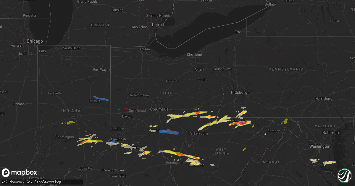
Hail Map in Ohio on June 8, 2022
Get this storm
June 8 map
$229
one time, instant access
Download today. No call, no setup
Keep the $229
Bought the map and want the full workflow? Apply the entire $229 to a subscription within 7 days. None of it is wasted.
Every map, not just this one
This buys you this map. Subscription and you get every map we run, in the markets you choose from a few cities to whole states to nationwide. Plus real-time alerts the moment a storm fires.
Contact data
Name, contact info, occupancy, even credit band for addresses in the footprint. You go from where it hit to who to call.
Become the source they trust
Unlimited branding weather history reports on demand. You already have the documented answer ready for the property owner, and you are the one who showed up with it.
Property data and RoofTrace estimates
Pull up any address you have got, its value and the exact code rules for that jurisdiction, straight from One Click Code. Then RoofTrace estimates the squares, pitch, and roof value, priced the way you price.
Storm reports in Ohio
Ohio
| Date | Description |
|---|---|
| 06/08/20226:55 PM CDT | Fields flattened and tree limbs everywhere. |
| 06/08/20226:53 PM CDT | Trees down at morning street and harrison state. |
| 06/08/20226:52 PM CDT | Large branch from willow tree snapped. |
| 06/08/20226:48 PM CDT | Several trees down along state route 56. |
| 06/08/20226:47 PM CDT | A tree was blown down near the intersection of portland road and valley belle road. |
| 06/08/20226:46 PM CDT | Sheriff reported a tree down on county road 24. Time estimated from radar. |
| 06/08/20226:41 PM CDT | A local report indicates 1.00 inch wind near CAMBRIDGE |
| 06/08/20226:40 PM CDT | 8 inch healthy tree uprooted. Time estimated from radar. |
| 06/08/20226:30 PM CDT | Large tree limbs reported down. Time estimated from radar. |
| 06/08/20226:25 PM CDT | Large branch reported down from a healthy silver maple tree. Time estimated from radar. |
| 06/08/20226:25 PM CDT | Three 6 inch diameter tree limbs down near greenbrier and sr 247. Time estimated from radar. |
| 06/08/20226:23 PM CDT | Multiple trees were blown down in reading township. |
| 06/08/20226:18 PM CDT | Trees uprooted and snapped. A tree reported down on a camper. Near u.s. 68 and ripley-dayhill rd. Time estimated from radar. |
| 06/08/20226:17 PM CDT | Trees down along ripley-day hill road |
| 06/08/20226:15 PM CDT | Corrects time for previous tstm wnd dmg report from 7 ene marietta. Several areas of trees down. |
| 06/08/20226:11 PM CDT | Several large tree limbs downed near the intersection of katterman road and kratz road. |
| 06/08/20226:08 PM CDT | Large trees down. Medium sized limb down on a camper. Located near graham st and yankee rd. Time estimated from radar. |
| 06/08/20226:08 PM CDT | Large 6 to 8 inch branches reported down. Time estimated from radar. |
| 06/08/20226:08 PM CDT | Structures damaged around sardinia. Damage believed to be caused by a tornado based on radar depiction. Official confirmation to come after survey. |
| 06/08/20226:07 PM CDT | Ef0 tornado confirmed in sardinia ohio. Tree damage observed in and east of sardinia. |
| 06/08/20226:06 PM CDT | One large tree downed on tri-county highway west of sardinia. |
| 06/08/20226:06 PM CDT | Large trees uprooted along 13000 block of hamer rd. Possible tornado. Time estimated by radar. |
| 06/08/20226:06 PM CDT | Several large trees and tree limbs downed. A barn partially damaged as well. Time estimated by radar. |
| 06/08/20226:03 PM CDT | Multiple large limbs snapped and blown into field. |
| 06/08/20226:00 PM CDT | Wind damage to cabin. Multiple trees down. Localized flooding to secondary reservoir. |
| 06/08/20226:00 PM CDT | Wind damage to cabin. Multiple trees down. Localized flooding to secondary reservoir. |
| 06/08/20225:56 PM CDT | Small trees snapped at trunk. One tree uprooted in wet soil. |
| 06/08/20225:52 PM CDT | Large branches snapped off a large tree. |
| 06/08/20225:50 PM CDT | Numerous large trees reported down. Time estimated from radar. |
| 06/08/20225:50 PM CDT | Several large tree limbs downed and a barn damaged along carroll eastern rd northeast. Time estimated by radar. |
| 06/08/20225:50 PM CDT | Trees reported down. Time estimated from radar. |
| 06/08/20225:50 PM CDT | Trees reported down. Damage noted west and east of the property as well. Possible tornado. Time estimated from radar. |
| 06/08/20225:50 PM CDT | A few small trees down. Time estimated from radar. |
| 06/08/20225:50 PM CDT | Tree down into above ground pool. Time est. From radar. |
| 06/08/20225:50 PM CDT | Several large trees downed along n. Ludlow road near kennard kingscreek road. Possible tornado. Time estimated by radar. |
| 06/08/20225:45 PM CDT | Large tree limbs down.tornado possible. |
| 06/08/20225:45 PM CDT | Tree uprooted. Time estimated by radar. |
| 06/08/20225:43 PM CDT | Large tree reported down near west home rd and north fountain blvd. Possible tornado. Time estimated from radar. |
| 06/08/20225:42 PM CDT | Numerous trees down |
| 06/08/20225:42 PM CDT | Ef0 tornado confirmed in champaign county. Tree damage and some structural damage along path. |
| 06/08/20225:42 PM CDT | Numerous trees down... Fence damage. |
| 06/08/20225:36 PM CDT | 18 ft tree fell on house near delrey and troy roads. Time estimated from radar. |
| 06/08/20225:35 PM CDT | Report from mping: quarter |
| 06/08/20225:30 PM CDT | Emergency manager reports several trees down on houses in mercerville. |
| 06/08/20225:30 PM CDT | Several large trees damaged or uprooted in mercerville along with significant leaf shred... Vehicle damage and damage to house siding and windows due to large and wind |
| 06/08/20225:30 PM CDT | Large tree uprooted and minor damage to a shed near intersection of jefferson road and pickerington road. Time estimated by radar. |
| 06/08/20225:30 PM CDT | Picture sent via social media. |
| 06/08/20225:30 PM CDT | A local report indicates 1.75 inch wind near 5 N CROWN CITY |
| 06/08/20225:30 PM CDT | Emergency manager reports several trees down on houses in mercerville. |
| 06/08/20225:28 PM CDT | Several very large trees uprooted along spence road. Possible tornado. Time estimated by radar. |
| 06/08/20225:18 PM CDT | Tree uprooted. Possible tornado. Time estimated from radar. |
| 06/08/20225:15 PM CDT | Several areas of trees down. |
| 06/08/20225:07 PM CDT | Significant damage to a distribution center near interstate 75. Damage was caused by a tornado. Additional confirmation details to come after survey. |
| 06/08/20225:04 PM CDT | Compact car flipped. Tornado possible. Time estimated from radar |
| 06/08/20224:53 PM CDT | Nws survey confirms an ef2 tornado with a track length of 13.9 miles across miami county. Significant damage to several industrial buildings... A large number of trees. |
| 06/08/20224:42 PM CDT | Barn damaged on schnorf jones road. Possible tornado. |
| 06/08/20224:42 PM CDT | Nws survey confirms an ef1 tornado touched down and damaged barns and outbuildings... And heavily damaged a number of trees in southeast darke county. 2.5 mile track le |
| 06/08/20223:20 PM CDT | Reports of golf ball size hail. |
| 06/08/20226:14 AM CDT | A local report indicates 1.75 inch wind near 5 N CROWN CITY |
| 06/08/20226:08 AM CDT | Large 6 to 8 inch branches reported down. Time estimated from radar. |
| 06/08/20223:42 AM CDT | At 842 PM EDT, a severe thunderstorm was located 7 miles southeast of Brooksville, moving east at 45 mph. HAZARD...60 mph wind gusts. SOURCE...Radar indicated. IMPACT...Expect damage to trees and power lines. Locations impacted include... Maysville, Washington, Aberdeen, Lewisburg, Brooksville, Mount Olivet, Germantown, Sardis, Murphysville, Burika, Alhambra, Stonewall, Mays Lick, Mitchells Mill, Rectorville, Powersville, Peed, Helena, Hittville and US Route 62 at State Route 875. |
| 06/08/20223:38 AM CDT | At 838 PM EDT, a severe thunderstorm was located 9 miles southeast of Barnesville, moving east at 35 mph. HAZARD...60 mph wind gusts and quarter size hail. SOURCE...Radar indicated. IMPACT...Minor hail damage to vehicles is possible. Expect wind damage to trees and power lines, resulting in some power outages. Locations impacted include... Wheeling, Moundsville, Bellaire, Bethlehem, Triadelphia, Shadyside, McMechen, Powhatan Point, Glen Dale, Benwood, Beallsville, and Neffs. |
| 06/08/20223:12 AM CDT | At 812 PM EDT, a severe thunderstorm was located 11 miles southwest of Barnesville, moving east at 30 mph. HAZARD...60 mph wind gusts and quarter size hail. SOURCE...Radar indicated. IMPACT...Minor hail damage to vehicles is possible. Expect wind damage to trees and power lines, resulting in some power outages. Locations impacted include... Barnesville, Bethesda, Quaker City, Senecaville, Belmont, Beallsville, Summerfield, Jerusalem, Wilson, Somerton, Alledonia, and Batesville. |
| 06/08/20223:08 AM CDT | At 808 PM EDT, a severe thunderstorm was located 10 miles southwest of Hocking Hills State Park, or 11 miles northwest of Mcarthur, moving east at 55 mph. HAZARD...60 mph wind gusts. SOURCE...Radar indicated. IMPACT...Expect damage to roofs, siding, and trees. Locations impacted include... Athens, Mcarthur, Albany, Lake Hope State Park, Tuppers Plains, Chauncey, Zaleski, Amesville, Creola, Eagle Mills, Stroud Run State Park, Allensville and The Plains. |
| 06/08/20222:52 AM CDT | At 752 PM EDT, a severe thunderstorm was located near Sunbury, moving east at 40 mph. HAZARD...60 mph wind gusts. SOURCE...Radar indicated. IMPACT...Expect damage to trees and power lines. Locations impacted include... Newark, Johnstown, Sunbury, Utica, Hanover, Marne, Galena, Hartford, St. Louisville, Toboso, Fredonia, US Route 62 at State Route 661, Olive Green, Purity, Center Village and Fallsburg.This includes I-71 in Ohio between mile markers 127 and 128. |
| 06/08/20222:51 AM CDT | At 751 PM EDT, a severe thunderstorm was located 9 miles east of Byesville, or 10 miles west of Barnesville, moving east at 35 mph. HAZARD...60 mph wind gusts and quarter size hail. SOURCE...Radar indicated. IMPACT...Minor hail damage to vehicles is possible. Expect wind damage to trees and power lines, resulting in some power outages. Locations impacted include... Cambridge, Barnesville, Woodsfield, Caldwell, Freeport, Byesville, Bethesda, Antrim, Quaker City, Senecaville, Belmont, and Pleasant City. |
| 06/08/20222:48 AM CDT | At 748 PM EDT, severe thunderstorms were located along a line extending from near Mount Gilead to near Sparta to near Sunbury, moving east at 40 mph. HAZARD...60 mph wind gusts. SOURCE...Radar indicated. IMPACT...Expect damage to trees and power lines. Locations impacted include... Mount Vernon, Fredericktown, Gambier, Utica, Centerburg, Danville, Chesterville, Sparta, Waterford, Martinsburg, Gann, North Liberty and Bladensburg. |
| 06/08/20222:36 AM CDT | At 735 PM EDT, a severe thunderstorm was located 8 miles north of Bainbridge, moving east at 45 mph. HAZARD...60 mph wind gusts and quarter size hail. SOURCE...Radar indicated. IMPACT...Minor hail damage to vehicles is possible. Expect wind damage to trees and power lines. Locations impacted include... Chillicothe, Kingston, Bainbridge, North Folk Village, Frankfort, Londonderry, Laurelville, Adelphi, South Salem, Bourneville, Andersonville, Mooresville, Lattaville, Austin, South Bloomingville, Summithill, Knockemstiff, Richmond Dale, Massieville and Hallsville. |
| 06/08/20222:34 AM CDT | At 733 PM EDT, a severe thunderstorm was located near New Concord, or 7 miles southwest of Cambridge, moving east at 20 mph. HAZARD...60 mph wind gusts and quarter size hail. SOURCE...Radar indicated. IMPACT...Minor hail damage to vehicles is possible. Expect wind damage to trees and power lines, resulting in some power outages. Locations impacted include... Cambridge, New Concord, Byesville, Quaker City, Senecaville, Pleasant City, Cumberland, Lore City, Old Washington, Summerfield, Belle Valley, and Sarahsville. |
| 06/08/20222:27 AM CDT | At 727 PM EDT, a severe thunderstorm was located near Pine Grove, or near New Martinsville, moving northeast at 20 mph. HAZARD...60 mph wind gusts and quarter size hail. SOURCE...Radar indicated. IMPACT...Minor hail damage to vehicles is possible. Expect wind damage to trees and power lines, resulting in some power outages. Locations impacted include... New Martinsville, Pine Grove, Lynn Camp, Porters Falls, Wileyville, Big Run, Reader, Earnshaw, Knob Fork, and Littleton. |
| 06/08/20222:22 AM CDT | At 721 PM EDT, a severe thunderstorm was located near Delaware, moving east at 40 mph. HAZARD...60 mph wind gusts. SOURCE...Radar indicated. IMPACT...Expect damage to trees and power lines. Locations impacted include... Delaware, Sunbury, Ashley, Radnor, Delaware State Park, Olive Green, Stratford, Warrensburg, Leonardsburg and Kilbourne.This includes I-71 in Ohio between mile markers 130 and 138. |
| 06/08/20222:20 AM CDT | At 720 PM EDT, a severe thunderstorm was located 9 miles southwest of Hocking Hills State Park, or 14 miles northwest of Mcarthur, moving east at 50 mph. HAZARD...70 mph wind gusts and penny size hail. SOURCE...Radar indicated. IMPACT...Expect considerable tree damage. Damage is likely to mobile homes, roofs, and outbuildings. Locations impacted include... Nelsonville, Lake Hope State Park, Buchtel, Creola and Eagle Mills. |
| 06/08/20222:16 AM CDT | At 716 PM EDT, a severe thunderstorm was located over Prospect, or 9 miles south of Marion, moving east at 35 mph. HAZARD...60 mph wind gusts. SOURCE...Radar indicated. IMPACT...Expect damage to trees and power lines. Locations impacted include... Marion, Mount Gilead, Cardington, Ashley, Prospect, Waldo, Edison, Green Camp, Marengo, Fulton and State Route 229 at US Route 23. |
| 06/08/20222:12 AM CDT | At 712 PM EDT, a severe thunderstorm was located over Sistersville, or 7 miles northwest of Middlebourne, moving northeast at 25 mph. HAZARD...60 mph wind gusts and quarter size hail. SOURCE...Radar indicated. IMPACT...Minor hail damage to vehicles is possible. Expect wind damage to trees and power lines, resulting in some power outages. Locations impacted include... New Martinsville, Paden City, Sardis, Fly, Cameron, Antioch, Porters Falls, Hannibal, Rinard Mills, Laings, and Proctor. |
| 06/08/20222:11 AM CDT | At 710 PM EDT, a severe thunderstorm was located 7 miles southeast of South Zanesville, or 10 miles southeast of Zanesville, moving east at 20 mph. HAZARD...60 mph wind gusts and quarter size hail. SOURCE...Radar indicated. IMPACT...Minor hail damage to vehicles is possible. Expect wind damage to trees and power lines, resulting in some power outages. Locations impacted include... Zanesville, New Concord, South Zanesville, Philo, Pleasant Grove, Cumberland, Norwich, Cannelville, High Hill, Chandlersville, Ruraldale, and Bridgeville. |
| 06/08/20222:04 AM CDT | At 703 PM EDT, severe thunderstorms were located along a line extending from 6 miles southwest of Fort Recovery to near Winchester, moving east at 45 mph. HAZARD...70 mph wind gusts. SOURCE...Radar indicated. IMPACT...Expect considerable tree damage. Damage is likely to mobile homes, roofs, and outbuildings. These severe thunderstorms will remain over mainly rural areas of northeastern Randolph County. |
| 06/08/20222:00 AM CDT | At 700 PM EDT, a severe thunderstorm was located near Pleasantville, or 8 miles west of Somerset, moving east at 30 mph. HAZARD...60 mph wind gusts and quarter size hail. SOURCE...Radar indicated. IMPACT...Hail damage to vehicles is expected. Expect wind damage to roofs, siding, and trees. Locations impacted include... New Lexington, Somerset, Perry State Forest, Crooksville and Junction City. |
| 06/08/20222:00 AM CDT | At 700 PM EDT, a severe thunderstorm was located near Pleasantville, moving east at 30 mph. HAZARD...60 mph wind gusts and quarter size hail. SOURCE...Radar indicated. IMPACT...Minor hail damage to vehicles is possible. Expect wind damage to trees and power lines. Locations impacted include... Lancaster, Bremen, Pleasantville, Rushville, West Rushville and North Berne. |
| 06/08/20221:57 AM CDT | At 657 PM EDT, a severe thunderstorm was located over Marietta, moving east at 30 mph. HAZARD...60 mph wind gusts and quarter size hail. SOURCE...Radar indicated. IMPACT...Hail damage to vehicles is expected. Expect wind damage to roofs, siding, and trees. Locations impacted include... Marietta, St. Marys, Newport, Matamoras, Friendly, Arvilla, Point Lookout, New Matamoras and Devola.This includes Interstate 77 in Ohio between mile markers 1 and 6. |
| 06/08/20221:51 AM CDT | At 650 PM EDT, a severe thunderstorm was located 10 miles west of Buffalo, or 11 miles south of Gallipolis, moving east at 25 mph. HAZARD...Golf ball size hail and 70 mph wind gusts. SOURCE...Radar indicated. IMPACT...People and animals outdoors will be injured. Expect hail damage to roofs, siding, windows, and vehicles. Expect considerable tree damage. Wind damage is also likely to mobile homes, roofs, and outbuildings. Locations impacted include... Winfield, Eleanor, Buffalo, Bancroft, Grimms Landing, Southside, Fraziers Bottom and Ashton. |
| 06/08/20221:48 AM CDT | At 647 PM EDT, a severe thunderstorm was located near Gambier, or 7 miles east of Mount Vernon, moving north at 60 mph. HAZARD...60 mph wind gusts and quarter size hail. SOURCE...Radar indicated. IMPACT...Minor hail damage to vehicles is possible. Expect wind damage to trees and power lines, resulting in some power outages. Locations impacted include... Zanesville, South Zanesville, Philo, Pleasant Grove, Fultonham, Norwich, Cannelville, High Hill, Chandlersville, Ruraldale, Bridgeville, and Duncan Falls. |
| 06/08/20221:47 AM CDT | At 646 PM EDT, a severe thunderstorm was located over Perry State Forest, moving east at 30 mph. HAZARD...60 mph wind gusts and quarter size hail. SOURCE...Radar indicated. IMPACT...Hail damage to vehicles is expected. Expect wind damage to roofs, siding, and trees. Locations impacted include... New Lexington, Perry State Forest, Crooksville and Eagleport. |
| 06/08/20221:46 AM CDT | At 645 PM EDT, a severe thunderstorm was located over Perry State Forest, moving east at 30 mph. HAZARD...60 mph wind gusts and quarter size hail. SOURCE...Radar indicated. IMPACT...Hail damage to vehicles is expected. Expect wind damage to roofs, siding, and trees. Locations impacted include... New Lexington, Perry State Forest, Crooksville and Eagleport. |
| 06/08/20221:43 AM CDT | At 642 PM EDT, a severe thunderstorm was located near Baltimore, moving northeast at 35 mph. HAZARD...60 mph wind gusts and penny size hail. SOURCE...Radar indicated. IMPACT...Expect damage to trees and power lines. Locations impacted include... Newark, Lancaster, Pickerington, Heath, Canal Winchester, Baltimore, Buckeye Lake, Hebron, Millersport, Pleasantville, Fairfield Beach, Harbor Hills, Thornport, Thurston, Kirkersville, Carroll, Fairfield County Airport, State Route 158 at State Route 204, Interstate 70 at State Route 37 and Interstate 70 at State Route 13.This includes I-70 in Ohio between mile markers 122 and 139. |
| 06/08/202212:46 AM CDT | At 546 PM EDT, a severe thunderstorm was located near South Webster, or near Wheelersburg, moving east at 30 mph. HAZARD...60 mph wind gusts and quarter size hail. SOURCE...Radar indicated. IMPACT...Hail damage to vehicles is expected. Expect wind damage to roofs, siding, and trees. Locations impacted include... Gallia, Vernon, Waterloo and Gage. |
| 06/08/202212:19 AM CDT | At 519 PM EDT, a severe thunderstorm was located over Greenville, moving east at 35 mph. HAZARD...60 mph wind gusts and penny size hail. SOURCE...Radar indicated. IMPACT...Expect damage to trees and power lines. Locations impacted include... Troy, Sidney, Piqua, Greenville, Tipp City, West Milton, Versailles, Covington, Arcanum, Bradford, Pleasant Hill, Ansonia, Hardin, Webster, Wayne Lakes, Russia, Gettysburg, Laura, Fletcher and Pitsburg.This includes I-75 in Ohio between mile markers 69 and 93. |
| 06/08/202212:17 AM CDT | At 517 PM EDT, a severe thunderstorm was located near Liberty, moving east at 30 mph. HAZARD...60 mph wind gusts and penny size hail. SOURCE...Radar indicated. IMPACT...Expect damage to trees and power lines. Locations impacted include... Oxford, Eaton, Liberty, Camden, Gratis, Seven Mile, West College Corner, Darrtown, Salem, Brownsville, College Corner, Somerville, West Elkton, Dunlapsville, Whitewater State Park, Goodwins Corner, Collinsville, Cottage Grove, Morning Sun and Wheatville. |
| 06/07/20229:19 PM CDT | A few trees down. |
| 06/07/20229:06 PM CDT | Report of trees and power lines down on east washington street and other streets in lisbon... Oh. |
| 06/07/20228:50 PM CDT | Trees down; time estimate from radar |
| 06/07/20228:15 PM CDT | Trees down. Time estimate based on radar |
| 06/07/20227:59 PM CDT | A few trees down on state route 148 |
| 06/07/20227:58 PM CDT | Trees down. Time estimate based from radar |
| 06/07/20227:57 PM CDT | A local report indicates 1.75 inch wind near WOODSFIELD |
| 06/07/20227:56 PM CDT | Trees down. |
| 06/07/20227:54 PM CDT | Trees down |
| 06/07/20227:48 PM CDT | Large tree down on goosecreek road. |
| 06/07/20227:27 PM CDT | Several trees reported down along state route 144. Time estimated from radar. |
| 06/07/20227:20 PM CDT | Tops of several trees blown down on macedonia road closing the road. |
| 06/07/20227:13 PM CDT | Tree down on rosedale road |
| 06/07/20227:08 PM CDT | Several trees were blown down along narrows road. |
| 06/07/20227:03 PM CDT | Tree down on institute rd |
| 06/07/20227:02 PM CDT | Trees and powerline reported down. Time estimated from radar. |
| 06/07/20227:00 PM CDT | Several large limbs reported down. Time estimated from radar. |
All States Impacted by Hail Map on June 8, 2022
Cities Impacted by Hail Map on June 8, 2022
- Chouteau, OK
- Elizabethtown, IN
- Seymour, IN
- Butlerville, IN
- Versailles, IN
- Osgood, IN
- Scipio, IN
- Jonesville, IN
- Holton, IN
- Brownstown, IN
- Westport, IN
- Columbus, IN
- Greensburg, IN
- North Vernon, IN
- Madison, IN
- Sarahsville, OH
- Woodsfield, OH
- Beallsville, OH
- Summerfield, OH
- Caldwell, OH
- Lewisville, OH
- Clarington, OH
- Graysville, OH
- Carmichaels, PA
- Jefferson, PA
- Portsmouth, OH
- White Cottage, OH
- Zanesville, OH
- Roseville, OH
- Mooresville, IN
- Oxford, NC
- Proctor, WV
- Waynesburg, PA
- Patriot, OH
- Seagrove, NC
- Holdenville, OK
- Sweetwater, OK
- Lesage, WV
- Maysville, OK
- Pauls Valley, OK
- Lindsay, OK
- Lexington, OK
- Ridgeville, SC
- Summerville, SC
- Searcy, AR
- Augusta, AR
- Coweta, OK
- Porter, OK
- Locust Grove, OK
- Dix, IL
- Mount Vernon, IL
- Red House, WV
- Charleston, WV
- Poca, WV
- Liberty, WV
- Spruce Pine, AL
- Hodges, AL
- Phil Campbell, AL
- Russellville, AL
- Vina, AL
- Red Bay, AL
- Groom, TX
- Poyen, AR
- Malvern, AR
- Beaverton, AL
- Blanchard, OK
- Tuttle, OK
- Norman, OK
- Newcastle, OK
- Amber, OK
- Truth Or Consequences, NM
- Stonewall, OK
- Fitzhugh, OK
- Macomb, OK
- Dierks, AR
- Masontown, PA
- Uniontown, PA
- McClellandtown, PA
- Smithfield, PA
- Greensboro, PA
- Welling, OK
- Sulligent, AL
- Sterrett, AL
- Harpersville, AL
- Clarksburg, OH
- Alamogordo, NM
- Cloudcroft, NM
- Foster, KY
- Brooksville, KY
- Dunnellon, FL
- Pinson, AL
- Birmingham, AL
- Trussville, AL
- Tremont, MS
- Smithville, MS
- Hamilton, AL
- Fulton, MS
- Detroit, AL
- Greenwood Springs, MS
- Fort Stockton, TX
- El Dorado, AR
- Ripley, OH
- Winchester, OH
- Russellville, OH
- Manchester, OH
- West Union, OH
- Peebles, OH
- Sentinel, OK
- Dill City, OK
- Port Republic, MD
- Newburg, MD
- Charlotte Hall, MD
- Prince Frederick, MD
- Lusby, MD
- Saint Leonard, MD
- Mechanicsville, MD
- Hollywood, MD
- Broomes Island, MD
- Asher, OK
- Konawa, OK
- Purcell, OK
- Beverly Hills, FL
- Hernando, FL
- Charleston, AR
- Point Marion, PA
- Martin, PA
- Bobtown, PA
- Nemacolin, PA
- Morgantown, WV
- Dilliner, PA
- Maidsville, WV
- Adah, PA
- New Salem, PA
- Ronco, PA
- Garards Fort, PA
- Mount Morris, PA
- Uledi, PA
- Lamar, OK
- Mcalester, OK
- Burlington, WV
- New Creek, WV
- Batesville, IN
- Currituck, NC
- Moyock, NC
- Quinton, OK
- Stigler, OK
- Brownsville, PA
- Allison, PA
- Denbo, PA
- Hiller, PA
- East Millsboro, PA
- Merrittstown, PA
- Vanderbilt, PA
- Grindstone, PA
- Smock, PA
- Maud, OK
- Balmorhea, TX
- Erick, OK
- Van Horn, TX
- Park Hill, OK
- Tahlequah, OK
- Dyer, AR
- Van Buren, AR
- Lavaca, AR
- Fort Smith, AR
- Alma, AR
- Greenwood, AR
- Fairview, WV
- Rivesville, WV
- Farmington, WV
- Fairmont, WV
- Lexington, KY
- Sparkman, AR
- Pampa, TX
- Cambridge, OH
- Bretz, WV
- Masontown, WV
- Independence, WV
- Montana Mines, WV
- Mannington, WV
- Kingwood, WV
- Bruceton Mills, WV
- Reedsville, WV
- Albright, WV
- Rachel, WV
- Baxter, WV
- Sayre, OK
- Rocky, OK
- Hobart, OK
- Amberg, WI
- Pembine, WI
- Littleton, WV
- New Martinsville, WV
- Rayville, LA
- Oviedo, FL
- Wynnewood, OK
- Palatka, FL
- Green Cove Springs, FL
- Georgetown, OH
- Bethel, OH
- Hamersville, OH
- Branch, AR
- Winter Park, FL
- Winter Springs, FL
- Casselberry, FL
- Maitland, FL
- Sanford, FL
- Stafford, VA
- Quantico, VA
- Nanjemoy, MD
- Indian Head, MD
- Tularosa, NM
- Carnegie, OK
- Anadarko, OK
- Binger, OK
- Gracemont, OK
- Corn, OK
- Lookeba, OK
- Bessie, OK
- Clinton, OK
- Pocasset, OK
- Arapaho, OK
- Weatherford, OK
- Hydro, OK
- Cordell, OK
- Fort Cobb, OK
- Minco, OK
- Chickasha, OK
- Colony, OK
- Foss, OK
- Dumas, MS
- New Albany, MS
- Ripley, MS
- Blue Mountain, MS
- Somerset, OH
- Junction City, OH
- Cement, OK
- Bixby, OK
- Broken Arrow, OK
- Marlow, OK
- Elgin, OK
- Rush Springs, OK
- Ninnekah, OK
- Bradley, OK
- Fletcher, OK
- Inola, OK
- Tulsa, OK
- Sand Springs, OK
- Cullman, AL
- Hanceville, AL
- Hopkins, SC
- Columbia, SC
- Eastover, SC
- Abbeville, SC
- Haskell, OK
- Dupont, IN
- Mcconnelsville, OH
- Cumberland, OH
- Gallipolis, OH
- Vinson, OK
- Hollis, OK
- Eufaula, OK
- Woodlawn, IL
- Bunch, OK
- Dardanelle, AR
- London, AR
- Delaware, AR
- Russellville, AR
- Danville, AR
- Atkins, AR
- Pottsville, AR
- Byesville, OH
- Kipling, OH
- Senecaville, OH
- Lynx, OH
- Vanceburg, KY
- Stout, OH
- Aberdeen, OH
- Maysville, KY
- Proctorville, OH
- Nichols, SC
- New Matamoras, OH
- Reno, OH
- Williamstown, WV
- Whipple, OH
- Marietta, OH
- Newport, OH
- Verden, OK
- Geary, OK
- Hinton, OK
- Cleveland, OK
- Hominy, OK
- Prue, OK
- Osage, OK
- Inverness, FL
- Lancaster, OH
- Fort Sill, OK
- Bamberg, SC
- Healdton, OK
- Logan, AL
- Crane Hill, AL
- Tollesboro, KY
- Amanda, OH
- Quaker City, OH
- Pleasant City, OH
- Chandlersville, OH
- Pleasantville, OH
- Rushville, OH
- Philo, OH
- Carroll, OH
- Baltimore, OH
- New Lexington, OH
- Bremen, OH
- Crooksville, OH
- Blue Rock, OH
- Barnesville, OH
- Wellington, TX
- La Plata, MD
- Perryville, AR
- Paron, AR
- Plainview, AR
- Casa, AR
- Ola, AR
- Saint Cloud, FL
- Blountsville, AL
- Elkview, WV
- Clendenin, WV
- Augusta, KY
- Falmouth, KY
- Ratcliff, AR
- Nauvoo, AL
- Carbon Hill, AL
- White Sands Missile Range, NM
- Eastaboga, AL
- El Paso, TX
- Townley, AL
- Orrum, NC
- Latonia, KY
- Aurora, IN
- Florence, KY
- Rising Sun, IN
- Petersburg, KY
- Newport, KY
- Ft Mitchell, KY
- Union, KY
- Independence, KY
- Walton, KY
- Burlington, KY
- Cameron, WV
- Vienna, WV
- Pine Grove, WV
- Hundred, WV
- Paden City, WV
- Burton, WV
- Reader, WV
- New Freeport, PA
- Metz, WV
- Friendly, WV
- Middlebourne, WV
- Porters Falls, WV
- Wana, WV
- Aleppo, PA
- Sardis, OH
- Sistersville, WV
- Kenna, WV
- Buffalo, WV
- Paris, KY
- San Ysidro, NM
- Jemez Pueblo, NM
- Mayesville, SC
- Bishopville, SC
- Little Rock, AR
- Weleetka, OK
- Okemah, OK
- Sierra Blanca, TX
- Evergreen, NC
- Fort Davis, TX
- Benton, AR
- Alexander, AR
- Bryant, AR
- Davis, OK
- Sulphur, OK
- Vernon, AL
- Frankfort, OH
- Chillicothe, OH
- Greenfield, OH
- South Salem, OH
- Wewoka, OK
- Welcome, MD
- Mount Pleasant, TN
- Columbia, TN
- Belleville, AR
- Claude, TX
- Baileyton, AL
- Eva, AL
- Owasso, OK
- Catoosa, OK
- Dunbar, WV
- Hurricane, WV
- Scott Depot, WV
- Saint Albans, WV
- Winfield, WV
- Nitro, WV
- Hope, IN
- New Concord, OH
- Washington Court House, OH
- Galax, VA
- Fair Bluff, NC
- Houston, AL
- Addison, AL
- Walters, OK
- Faxon, OK
- Salt Flat, TX
- Dell City, TX
- Vincent, AL
- Mclean, TX
- Peggs, OK
- Rose, OK
- Salina, OK
- Pryor, OK
- Hartsville, IN
- Havana, AR
- Roxboro, NC
- Wheelersburg, OH
- Port Tobacco, MD
- Melbourne, KY
- California, KY
- Moscow, OH
- Butler, KY
- Alexandria, KY
- New Richmond, OH
- Felicity, OH
- Noble, OK
- Fraziers Bottom, WV
- Waterloo, OH
- South Shore, KY
- Willow Wood, OH
- Franklin Furnace, OH
- Glenwood, WV
- Pedro, OH
- Leon, WV
- South Portsmouth, KY
- Apple Grove, WV
- Crown City, OH
- Scottown, OH
- Ashton, WV
- South Webster, OH
- Kitts Hill, OH
- Chesapeake, OH
- Grafton, WV
- Bethesda, OH
- Belmont, OH
- Bickmore, WV
- Swiss, WV
- Clay, WV
- Summersville, WV
- Monrovia, IN
- Martinsville, IN
- Calhoun, GA
- Ona, WV
- South Charleston, WV
- Eleanor, WV
- Chaparral, NM
- Benoit, MS
- Hayden, AL
- Camden, SC
- Nobleton, FL
- Bushnell, FL
- Brooksville, FL
- Okeechobee, FL
- Eldridge, AL
- Nettleton, MS
- Okolona, MS
- Fort Hancock, TX
- Advent, WV
- De Queen, AR
- Nashoba, OK
- Waurika, OK
- Pioneer, LA
- Oak Grove, LA
- Mer Rouge, LA
- Lake Providence, LA
- Fairbank, PA
- Rices Landing, PA
- Crucible, PA
- New Geneva, PA
- Bear Creek, AL
- Woodstock, AL
- Vance, AL
- Hackleburg, AL
- Paoli, OK
- Arthurdale, WV
- Jerusalem, OH
- Floral City, FL
- Mullins, SC
- Blue Creek, OH
- Erlanger, KY
- Gallipolis Ferry, WV
- Southside, WV
- Williamsport, OH
- Wingett Run, OH
- Cameron, OH
- Woodlawn, VA
- Hancock, MD
- Berkeley Springs, WV
- Great Cacapon, WV
- Beverly, WV
- Glady, WV
- Terra Alta, WV
- Laguna, NM
- Cimarron, NM
- Mountain View, OK
- Willow, OK
- Mangum, OK
- Chattanooga, OK
- Lone Wolf, OK
- Burkburnett, TX
- Snyder, OK
- Oklaunion, TX
- Butler, OK
- Frederick, OK
- Iowa Park, TX
- Headrick, OK
- Electra, TX
- Cache, OK
- Gotebo, OK
- Canute, OK
- Harrold, TX
- Devol, OK
- Geronimo, OK
- Blair, OK
- Davidson, OK
- Holliday, TX
- Hollister, OK
- Roosevelt, OK
- Seymour, TX
- Loveland, OK
- Indiahoma, OK
- Mountain Park, OK
- Tipton, OK
- Elk City, OK
- Randlett, OK
- Grandfield, OK
- Vernon, TX
- Wichita Falls, TX
- Granite, OK
- Sheppard Afb, TX
- Carter, OK
- Lawton, OK
- Wagoner, OK
- Hulbert, OK
- Cookson, OK
- Muldrow, OK
- Fort Gibson, OK
- Stilwell, OK
- Uniontown, AR
- Calvin, OK
- Wetumka, OK
- Stuart, OK
- Allen, OK
- Atwood, OK
- Roland, AR
- Bigelow, AR
- Hollandale, MS
- Cleveland, MS
- Itta Bena, MS
- Isola, MS
- Greenville, MS
- Dermott, AR
- Grady, AR
- Wilmar, AR
- Moorhead, MS
- Star City, AR
- Shaw, MS
- Belzoni, MS
- Indianola, MS
- Boyle, MS
- Monticello, AR
- Arkansas City, AR
- Leland, MS
- Warren, AR
- Inverness, MS
- Rison, AR
- Dumas, AR
- Beulah, MS
- Tillar, AR
- McGehee, AR
- Rohwer, AR
- Vardaman, MS
- Grenada, MS
- Woodland, MS
- Gore Springs, MS
- Houston, MS
- Calhoun City, MS
- Duck Hill, MS
- Mantee, MS
- Rushville, IN
- Arlington, IN
- Arcanum, OH
- Troy, OH
- Tipp City, OH
- West Milton, OH
- Casstown, OH
- Springfield, OH
- Sardinia, OH
- South Bloomingville, OH
- Union City, IN
- Albany, IN
- Winchester, IN
- Farmland, IN
- Eaton, IN
- Parker City, IN
- Ridgeville, IN
- Muncie, IN
- Saratoga, IN
- Gaston, IN
- Milan, IN
- Dillsboro, IN
- Stilesville, IN
- Camby, IN
- Bargersville, IN
- Brooklyn, IN
- Greenwood, IN
- Ada, OK
- Stratford, OK
- Zaleski, OH
- Ray, OH
- Albany, OH
- New Plymouth, OH
- Athens, OH
- Creola, OH
- New Marshfield, OH
- McArthur, OH
- Londonderry, OH
- Hebron, KY
- Sharpsburg, GA
- Newnan, GA
- Carrollton, GA
- Franklin, GA
- Turkey, TX
- Flomot, TX
- Gould, OK
- Roaring Springs, TX
- Tulia, TX
- Quanah, TX
- Kress, TX
- Lockney, TX
- Wayside, TX
- Amarillo, TX
- Crosbyton, TX
- Plainview, TX
- Memphis, TX
- Ralls, TX
- Quitaque, TX
- Shamrock, TX
- Floydada, TX
- Happy, TX
- Clarendon, TX
- Dickens, TX
- Spur, TX
- Dodson, TX
- Paducah, TX
- Childress, TX
- Matador, TX
- Hedley, TX
- Mcadoo, TX
- Silverton, TX
- Lakeview, TX
- Lelia Lake, TX
- Afton, TX
- Wheeler, TX
- Canyon, TX
- Quail, TX


