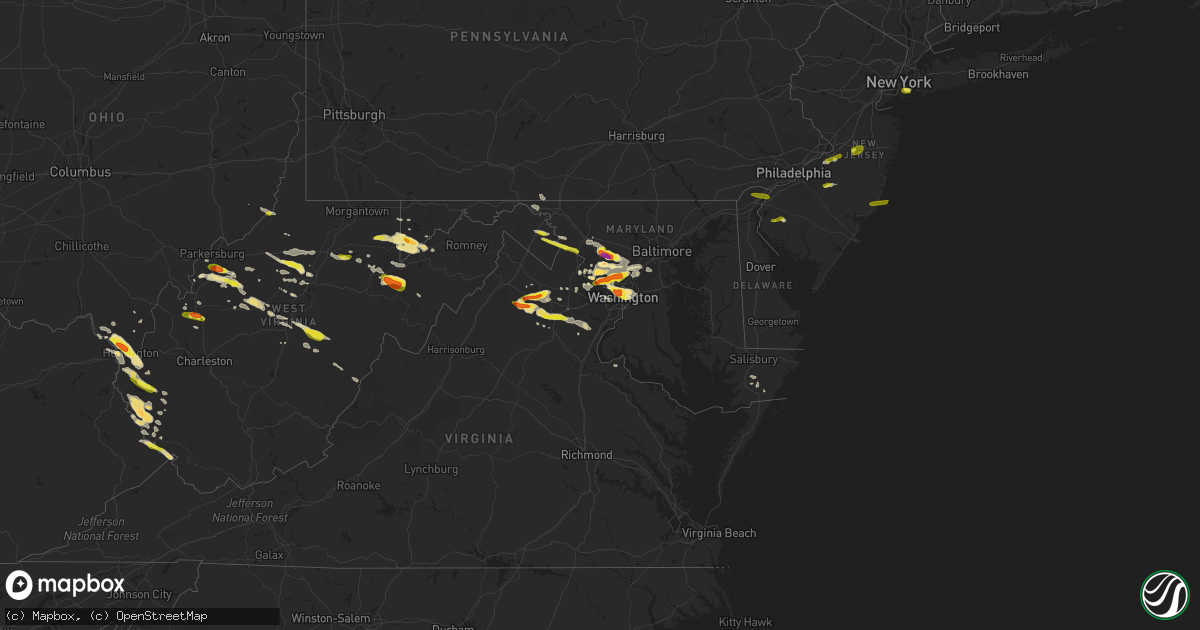
Hail Map in Maryland on June 2, 2019
Get this storm
June 2 map
$229
one time, instant access
Download today. No call, no setup
Keep the $229
Bought the map and want the full workflow? Apply the entire $229 to a subscription within 7 days. None of it is wasted.
Every map, not just this one
This buys you this map. Subscription and you get every map we run, in the markets you choose from a few cities to whole states to nationwide. Plus real-time alerts the moment a storm fires.
Contact data
Name, contact info, occupancy, even credit band for addresses in the footprint. You go from where it hit to who to call.
Become the source they trust
Unlimited branding weather history reports on demand. You already have the documented answer ready for the property owner, and you are the one who showed up with it.
Property data and RoofTrace estimates
Pull up any address you have got, its value and the exact code rules for that jurisdiction, straight from One Click Code. Then RoofTrace estimates the squares, pitch, and roof value, priced the way you price.
Storm reports in Maryland
Maryland
| Date | Description |
|---|---|
| 06/02/20196:37 PM CDT | U.s. Highway 301 closed at state highway 302 from wind damage and debris. Time estimated from radar. |
| 06/02/20195:41 PM CDT | Several 2 inch tree branches down |
| 06/02/20195:36 PM CDT | Tree branch down about 5 inches in diameter |
| 06/02/20195:31 PM CDT | Thunderstorm wind gust 58 mph |
| 06/02/20195:30 PM CDT | Tree down near on md-124 between kimblehunt dr and goshen school rd |
| 06/02/20195:27 PM CDT | Tree branch onto power lines along howard chapel rd |
| 06/02/20195:25 PM CDT | Couple trees down near intersection of stevens forest rd and broken land parkway |
| 06/02/20195:23 PM CDT | Tree down near intersection of broken land parkway and cradlerrock way |
| 06/02/20195:20 PM CDT | Tree down at the 10600 block of guilford rd |
| 06/02/20194:57 PM CDT | Tree on a house in the 15000 block of hunter mountain lane near park vista drive |
| 06/02/20194:56 PM CDT | A local report indicates 1.00 inch wind near 1 ESE NORBECK |
| 06/02/20194:55 PM CDT | Numerous trees down in aspen hill... Just off the icc. One tree on an suv. |
| 06/02/20194:55 PM CDT | A local report indicates 1.00 inch wind near 1 ESE NORBECK |
| 06/02/20194:54 PM CDT | A local report indicates 1.00 inch wind near 1 S ASPEN HILL |
| 06/02/20194:54 PM CDT | A local report indicates 1.00 inch wind near 1 NNE GLENMONT |
| 06/02/20194:54 PM CDT | Tree on house in the 2800 block of big bear terrace. |
| 06/02/20194:50 PM CDT | A local report indicates 1.75 inch wind near ROCKVILLE |
| 06/02/20194:50 PM CDT | A local report indicates 1.00 inch wind near 2 W COLESVILLE |
| 06/02/20194:47 PM CDT | A local report indicates 1.50 inch wind near 3 SSW DAMASCUS |
| 06/02/20194:46 PM CDT | Golf ball size hail near glen echo fire department |
| 06/02/20194:46 PM CDT | A local report indicates 1.00 inch wind near 2 NNE POTOMAC |
| 06/02/20194:45 PM CDT | A local report indicates 1.50 inch wind near 2 S ROCKVILLE |
| 06/02/20194:45 PM CDT | Hen egg size hail |
| 06/02/20194:45 PM CDT | Tree down at intersection of autumn wind way and rose petal way. |
| 06/02/20194:45 PM CDT | Ping pong ball size hail... Several sections of fence damaged... And a couple of tree branches down |
| 06/02/20194:45 PM CDT | Tree on car in the 25100 block of ridge road |
| 06/02/20194:45 PM CDT | Ping pong ball size hail... Several sections of fence damaged... And a couple of tree branches down |
| 06/02/20194:26 PM CDT | Tree branches down on western ave near fort bayard park. |
| 06/02/20192:06 PM CDT | Quarter sized hail reported in harper's ferry |
| 06/02/20191:24 PM CDT | Quarter to ping pong sized hail. |
| 06/02/20191:22 PM CDT | A local report indicates 1.00 inch wind near OAKLAND |
| 06/02/20192:10 AM CDT | At 710 PM EDT, severe thunderstorms were located along a line extending from 6 miles east of Waldorf to 6 miles southeast of La Plata, moving east at 45 mph. HAZARD...60 mph wind gusts. SOURCE...Radar indicated. IMPACT...Damaging winds will cause some trees and large branches to fall. This could injure those outdoors, as well as damage homes and vehicles. Roadways may become blocked by downed trees. Localized power outages are possible. Unsecured light objects may become projectiles. Locations impacted include... Waldorf, Chesapeake Ranch Estates, Prince Frederick, Sheridan Point, Hallowing Point, Saint Leonard Creek, Flag Harbor, Calvert Cliffs, California, Golden Beach, Lusby, Saint Leonard, Hollywood, Saint Charles, Drum Point, Hughesville, Baden, Long Beach, Mechanicsville and Charlotte Hall. |
| 06/02/20191:53 AM CDT | At 652 PM EDT, a severe thunderstorm was located near Dunkirk, or 8 miles northeast of Waldorf, moving east at 35 mph. HAZARD...60 mph wind gusts. SOURCE...Radar indicated. IMPACT...Damaging winds will cause some trees and large branches to fall. This could injure those outdoors, as well as damage homes and vehicles. Roadways may become blocked by downed trees. Localized power outages are possible. Unsecured light objects may become projectiles. Locations impacted include... Chesapeake Beach, Prince Frederick, Breezy Point, Rosaryville, Dunkirk, Huntingtown, Owings, Baden, Aquasco, Friendship, Eagle Harbor, Lower Marlboro, Sunderland, Cheltenham, Mount Harmony and Dares Beach. |
| 06/02/20191:27 AM CDT | At 627 PM EDT, a severe thunderstorm was located near Fort Belvoir, moving east at 35 mph. HAZARD...60 mph wind gusts and quarter size hail. SOURCE...Radar indicated. IMPACT...Damaging winds will cause some trees and large branches to fall. This could injure those outdoors, as well as damage homes and vehicles. Roadways may become blocked by downed trees. Localized power outages are possible. Unsecured light objects may become projectiles. Locations impacted include... Waldorf, Clinton, Fort Washington, Fort Hunt, Fort Belvoir, Lorton, Hybla Valley, Newington, Rosaryville, Friendly, Marlton, Dunkirk, Saint Charles, Mount Vernon, Accokeek, Bryans Road, Brandywine, Baden, Mason Neck and Potomac Heights. |
| 06/02/20191:25 AM CDT | At 625 PM EDT, a severe thunderstorm was located over Germantown, moving east at 30 mph. HAZARD...60 mph wind gusts and quarter size hail. SOURCE...Radar indicated. IMPACT...Damaging winds will cause some trees and large branches to fall. This could injure those outdoors, as well as damage homes and vehicles. Roadways may become blocked by downed trees. Localized power outages are possible. Unsecured light objects may become projectiles. Locations impacted include... Germantown, Gaithersburg, Olney, Damascus, Montgomery Village, Redland, Boyds, Clarksburg, Washington Grove and Laytonsville. |
| 06/02/20191:24 AM CDT | At 623 PM EDT, severe thunderstorms with a history of producing wind damage were located along a line extending from near Columbia to Fort Meade, moving east at 30 mph. HAZARD...60 mph wind gusts. SOURCE...Trained spotters. IMPACT...Damaging winds will cause some trees and large branches to fall. This could injure those outdoors, as well as damage homes and vehicles. Roadways may become blocked by downed trees. Localized power outages are possible. Unsecured light objects may become projectiles. Locations impacted include... Baltimore, Severn, Pikesville, Middle River, Elkridge, Riviera Beach, Baltimore-Washington Airport, Millers Island, North Point State Park, Sparrows Point, Back River, Glen Burnie, Dundalk, Towson, Catonsville, Essex, Woodlawn, Severna Park, Odenton and Parkville. |
| 06/02/201912:57 AM CDT | At 557 PM EDT, a severe thunderstorm was located near Montclair, or near Dale City, moving east at 20 mph. HAZARD...Ping pong ball size hail and 60 mph wind gusts. SOURCE...Radar indicated. IMPACT...Damaging winds will cause some trees and large branches to fall. This could injure those outdoors, as well as damage homes and vehicles. Roadways may become blocked by downed trees. Localized power outages are possible. Unsecured light objects may become projectiles. Locations impacted include... Dale City, Woodbridge, Quantico, Lake Ridge, Montclair, Triangle, Dumfries, Cherry Hill, Independent Hill, Bryans Road, Potomac Heights, Pomfret, Marbury, Ironsides, Ripley, Rison, Nanjemoy, Aquia, Pisgah and Welcome. |
| 06/02/201912:52 AM CDT | At 552 PM EDT, a severe thunderstorm was located over Oatlands, or near Broadlands, moving southeast at 30 mph. HAZARD...60 mph wind gusts and quarter size hail. SOURCE...Radar indicated. IMPACT...Damaging winds will cause some trees and large branches to fall. This could injure those outdoors, as well as damage homes and vehicles. Roadways may become blocked by downed trees. Localized power outages are possible. Unsecured light objects may become projectiles. Locations impacted include... Centreville, Reston, Leesburg, South Riding, Herndon, Fairfax, Vienna, Broadlands, Lansdowne, Lowes Island, Brambleton, Mantua, Dulles International Airport, Potomac, Ashburn, Oakton, Sterling, Chantilly, Tysons Corner and Wolf Trap. |
| 06/02/201912:46 AM CDT | At 546 PM EDT, a severe thunderstorm was located over Damascus, moving southeast at 30 mph. HAZARD...Ping pong ball size hail and 60 mph wind gusts. SOURCE...Radar indicated. IMPACT...Damaging winds will cause some trees and large branches to fall. This could injure those outdoors, as well as damage homes and vehicles. Roadways may become blocked by downed trees. Localized power outages are possible. Unsecured light objects may become projectiles. Locations impacted include... Columbia, Germantown, Olney, Damascus, Montgomery Village, Redland, Clarksburg, Highland, Laytonsville, Brookeville, Clarksville, Dayton, Roxbury Mills, Glenelg and Brinklow. |
| 06/02/201912:46 AM CDT | At 546 PM EDT, severe thunderstorms were located along a line extending from near Delta to near Betterton, moving northeast at 45 mph. HAZARD...60 mph wind gusts and quarter size hail. SOURCE...Radar indicated. IMPACT...Minor damage to vehicles is possible. Wind damage to roofs, siding, trees, and power lines is possible. Locations impacted include... Newark, Middletown, Elkton, Calvert, Coatesville, Kennett Square, Chestertown, Oxford, Parkesburg, North East, West Grove, Rising Sun, Honey Brook, Delaware City, Elverson, Charlestown, Cecilton, Betterton, Glen Roy and Blake. |
| 06/02/201912:43 AM CDT | At 543 PM EDT, a severe thunderstorm with a history of producing large hail was located over Potomac, or near Rockville, moving east at 20 mph. HAZARD...60 mph wind gusts and half dollar size hail. SOURCE...Trained spotters. IMPACT...Damaging winds will cause some trees and large branches to fall. This could injure those outdoors, as well as damage homes and vehicles. Roadways may become blocked by downed trees. Localized power outages are possible. Unsecured light objects may become projectiles. Locations impacted include... Rockville, Bethesda, Olney, Aspen Hill, Potomac, North Bethesda, North Potomac, Fairland, White Oak, Redland, Colesville, Kemp Mill, Chevy Chase, North Kensington, South Kensington, Forest Glen, Hillandale, North Chevy Chase, Wheaton-Glenmont and Rossmoor. |
| 06/02/201912:39 AM CDT | At 539 PM EDT, a severe thunderstorm was located near Bel Air South, or near Aberdeen, moving east at 25 mph. HAZARD...60 mph wind gusts and quarter size hail. SOURCE...Radar indicated. IMPACT...Damaging winds will cause some trees and large branches to fall. This could injure those outdoors, as well as damage homes and vehicles. Roadways may become blocked by downed trees. Localized power outages are possible. Unsecured light objects may become projectiles. Locations impacted include... Aberdeen, Havre De Grace, Aberdeen Proving Ground, Bel Air South, Bel Air North, Riverside, Perryman, Edgewood, Churchville, Carsins, Harford Furnace, Abingdon and Belcamp. |
| 06/02/201912:19 AM CDT | At 518 PM EDT, a severe thunderstorm was located over Ballenger Creek, or over Harry Grove Stadium, moving east at 30 mph. HAZARD...60 mph wind gusts and quarter size hail. SOURCE...Radar indicated. IMPACT...Damaging winds will cause some trees and large branches to fall. This could injure those outdoors, as well as damage homes and vehicles. Roadways may become blocked by downed trees. Localized power outages are possible. Unsecured light objects may become projectiles. Locations impacted include... Frederick, Damascus, Harry Grove Stadium, Eldersburg, Ballenger Creek, Mount Airy, Sykesville, New Market, Green Valley, Linganore-Bartonsville, Clover Hill, Clarksburg, Adamstown, Buckeystown, Monrovia, Doubs, Park Mills, Gaither, Poplar Springs and Roxbury Mills. |
| 06/02/201912:18 AM CDT | At 518 PM EDT, a severe thunderstorm was located near Jarrettsville, or 9 miles north of Cockeysville, moving east at 15 mph. HAZARD...60 mph wind gusts and quarter size hail. SOURCE...Radar indicated. IMPACT...Damaging winds will cause some trees and large branches to fall. This could injure those outdoors, as well as damage homes and vehicles. Roadways may become blocked by downed trees. Localized power outages are possible. Unsecured light objects may become projectiles. Locations impacted include... Bel Air North, Fallston, Jarrettsville, Pylesville, Darlington, Cardiff, Norrisville, Scarboro, Forest Hill, Chrome Hill, Bynum, Street, Rocks, Hickory and Whiteford. |
| 06/02/201912:13 AM CDT | At 512 PM EDT, a severe thunderstorm was located over Brambleton, moving east at 30 mph. HAZARD...Quarter size hail. SOURCE...Radar indicated. IMPACT...Some hail damage to agriculture is expected. Locations impacted include... Reston, Annandale, South Riding, Herndon, Vienna, Brambleton, Mantua, Dulles International Airport, Potomac, Ashburn, Oakton, Sterling, Chantilly, Tysons Corner, Wolf Trap, Great Falls, Merrifield, Arcola, I66 and I495 Interchange and Dunn Loring. |
| 06/01/201911:40 PM CDT | At 440 PM EDT, a severe thunderstorm was located over Countryside, or near Lowes Island, moving east at 25 mph. HAZARD...Quarter size hail. SOURCE...Radar indicated. IMPACT...Some hail damage to agriculture is expected. Locations impacted include... Germantown, Rockville, Bethesda, Gaithersburg, Olney, Lansdowne, Lowes Island, Poolesville, Mclean, American Legion Bridge, Aspen Hill, Potomac, North Bethesda, Ashburn, North Potomac, Fairland, White Oak, Redland, Great Falls and Colesville. |
| 06/01/201911:00 PM CDT | Courthouse hill rd between cokesbury and pocomoke city. |
| 06/01/201910:53 PM CDT | At 352 PM EDT, a severe thunderstorm was located near Big Cove Tannery, moving east at 20 mph. HAZARD...60 mph wind gusts and quarter size hail. SOURCE...Radar indicated. IMPACT...Hail damage to vehicles is expected. Expect wind damage to trees, roofs, and siding. Locations impacted include... Waynesboro, Greencastle, Wayne Heights, Mont Alto, Mercersburg, Rouzerville, Marion, Claylick, State Line, Quincy, Williamson, Upton, Whitetail Ski Area and Penn State Mont Alto.This includes Interstate 81 from mile markers 1 to 11. |
| 06/01/201910:17 PM CDT | At 317 PM EDT, a severe thunderstorm with a history of producing quarter size hail was located over Brunswick, or 10 miles east of Charles Town, moving east at 10 mph. HAZARD...Quarter size hail. SOURCE...Trained weather spotters. IMPACT...Some hail damage to agriculture is expected. Locations impacted include... Brunswick, Point Of Rocks, Adamstown, Lovettsville, Buckeystown, Rosemont, Knoxville, Petersville, Doubs, Tuscarora, Lucketts and Taylorstown. |
| 06/01/20199:16 PM CDT | At 216 PM EDT, a severe thunderstorm was located near Oakland, moving east at 30 mph. HAZARD...Wind gusts to 60 mph and quarter-size hail. SOURCE...Radar. IMPACT...Minor hail damage to vehicles is possible. Expect wind damage to trees and power lines, resulting in some power outages. Locations impacted include... Mountain Lake Park... Oakland... Bayard... Loch Lynn Heights... Deer Park... Redhouse... Hutton... Gorman... Crellin... Cathedral State Park... Aurora... Elgon... |
| 06/01/20197:25 PM CDT | Trees downed onto power line in the area of wildwood trail in princess anne. |
All States Impacted by Hail Map on June 2, 2019
Cities Impacted by Hail Map on June 2, 2019
- Ripley, WV
- Cream Ridge, NJ
- Hope, NM
- Artesia, NM
- Fayetteville, AR
- Springdale, AR
- Gainesville, VA
- Glen Echo, MD
- McLean, VA
- Chevy Chase, MD
- Washington, DC
- Bethesda, MD
- Santa Fe, NM
- Salem, WV
- Clarksburg, WV
- West Union, WV
- New Milton, WV
- Roswell, NM
- Ceredo, WV
- Ashland, KY
- Huntington, WV
- Catlettsburg, KY
- Kenova, WV
- South Point, OH
- Hagerman, NM
- Lovington, NM
- Tinnie, NM
- Dexter, NM
- Harts, WV
- West Chester, PA
- Delaplane, VA
- Markham, VA
- Tijeras, NM
- Given, WV
- Lake Arthur, NM
- Clear Spring, MD
- Big Pool, MD
- Marlinton, WV
- The Plains, VA
- Jacksonburg, WV
- Alma, WV
- Chapmanville, WV
- Hermosa, SD
- Rapid City, SD
- Black Hawk, SD
- Fairburn, SD
- Buffalo Gap, SD
- Keystone, SD
- Orma, WV
- Arnoldsburg, WV
- Mount Zion, WV
- Grantsville, WV
- Normantown, WV
- Millstone, WV
- Goodwell, OK
- Harrisville, WV
- Smithville, WV
- Medora, ND
- Oakland, MD
- Lowell, AR
- Rogers, AR
- Wilmington, DE
- Mineral Wells, WV
- Elizabeth, WV
- Sandia Park, NM
- Peralta, NM
- Edgewood, NM
- Raton, NM
- Saint Paul, NE
- Bladensburg, MD
- Arlington, VA
- Brentwood, MD
- Potomac, MD
- Rockville, MD
- Kensington, MD
- Garrett Park, MD
- Silver Spring, MD
- Hyattsville, MD
- Derwood, MD
- Great Falls, VA
- Spencerville, MD
- Mount Rainier, MD
- Cabin John, MD
- Gaithersburg, MD
- Clarksburg, MD
- Germantown, MD
- Ijamsville, MD
- Damascus, MD
- Kimball, NE
- Bosque Farms, NM
- Los Lunas, NM
- Belen, NM
- Maxwell, NM
- Cimarron, NM
- Bowman, ND
- Rhame, ND
- Amidon, ND
- Vincentown, NJ
- Yoder, WY
- Guernsey, WY
- Wheatland, WY
- Robeline, LA
- Coushatta, LA
- Marthaville, LA
- Pedro, OH
- Ironton, OH
- Franklin Furnace, OH
- Walker, WV
- Scottown, OH
- Willow Wood, OH
- Pine Bluffs, WY
- Shawnee, WY
- Greenup, KY
- Columbus, NJ
- Friendsville, MD
- Terra Alta, WV
- McHenry, MD
- Sharpsburg, MD
- Rohrersville, MD
- Keedysville, MD
- Knoxville, MD
- Marshall, VA
- Linden, VA
- Front Royal, VA
- Upperville, VA
- Campo, CO
- Boise City, OK
- Kenton, OK
- Upper Tract, WV
- Cabins, WV
- Marathon, TX
- Philippi, WV
- Moatsville, WV
- Rowlesburg, WV
- Eglon, WV
- Gormania, WV
- Tunnelton, WV
- Aurora, WV
- Grenville, NM
- Spencer, WV
- Seminole, TX
- Elmer, NJ
- Dryfork, WV
- Davis, WV
- Parsons, WV
- Red Creek, WV
- Hambleton, WV
- Hendricks, WV
- Crawford, NE
- Cheyenne, WY
- Sterling, VA
- Milnesand, NM
- Burlington, NJ
- Shenandoah Junction, WV
- Brunswick, MD
- Kearneysville, WV
- Lovettsville, VA
- Point Of Rocks, MD
- Harpers Ferry, WV
- Jefferson, MD
- King George, VA
- Saint Francis, KS
- Mount Airy, MD
- Brookeville, MD
- Monrovia, MD
- Ulysses, KS
- Satanta, KS
- Ashburn, VA
- Herndon, VA
- Williamson, WV
- Belfry, KY
- Martinsburg, WV
- Shepherdstown, WV
- Leland, NC
- Valentine, TX
- Martin, SD
- Manassas, VA
- Nokesville, VA
- Bristow, VA
- Sentinel Butte, ND
- Douglas, WY
- Hertford, NC
- Malvern, PA
- Phoenixville, PA
- Eads, CO
- Kenna, WV
- Liberty, WV
- Bordentown, NJ
- Mount Holly, NJ
- Kermit, WV
- Crum, WV
- Lenore, WV
- Dunlow, WV
- Warfield, KY
- Dingess, WV
- Breeden, WV
- Lovely, KY
- Wilsondale, WV
- Genoa, WV
- Fort Gay, WV
- Shock, WV
- Catlett, VA
- Warrenton, VA
- Tuthill, SD
- Dover, DE
- Cheswold, DE
- Troy, WV
- Columbia, MD
- Fulton, MD
- Ashton, MD
- Laurel, MD
- Lincoln University, PA
- Oxford, PA
- West Grove, PA
- Webster Springs, WV
- Diana, WV
- Hacker Valley, WV
- Cowen, WV
- Sutton, WV
- Pocomoke City, MD
- Palestine, WV
- Columbia, NC
- Lancaster, PA
- Willow Street, PA
- Nemo, SD
- Piedmont, SD
- Munday, WV
- Springer, NM
- Flemington, WV
- Chester Gap, VA
- Hume, VA
- Flint Hill, VA
- Huntly, VA
- Cerrillos, NM
- Bushnell, NE
- Poolesville, MD
- Boyds, MD
- Cody, NE
- Weston, WV
- Jane Lew, WV
- Kitts Hill, OH
- Chesapeake, OH
- Burnsville, WV
- Linn, WV
- Carpenter, WY
- Burns, WY
- Elk Garden, WV
- Mount Storm, WV
- Crookston, NE
- Harrisburg, NE
- Dickerson, MD
- Jarales, NM
- Laguna, NM
- Delbarton, WV
- Golva, ND
- Dell City, TX
- East Lynn, WV
- Ranger, WV
- Branchland, WV
- Mercersburg, PA
- Haswell, CO
- Kilgore, NE
- Saint Francis, SD
- Accident, MD
- Swanton, MD
- Birch River, WV
- Rosedale, WV
- Gassaway, WV
- Cheyney, PA
- Glen Mills, PA
- Thornton, PA
- Little Birch, WV
- Forest Hills, KY
- Hardy, KY
- McCarr, KY
- Alpine, TX
- Glenville, WV
- Camden, WV
- Estancia, NM
- Brooklyn, NY
- Aldie, VA
- Belleville, WV
- Ravenswood, WV
- Rockport, WV
- Majestic, KY
- Hurley, VA
- Matewan, WV
- Stopover, KY
- Elkins, AR
- Lavalette, WV
- Barboursville, WV
- Wayne, WV
- Paden City, WV
- New Martinsville, WV
- Sardis, OH
- Fort Davis, TX
- Marfa, TX
- Nenzel, NE
- Chadron, NE
- Newburg, WV
- Kingwood, WV
- Wesley, AR
- Wanblee, SD
- Harrison, NE
- Whitney, NE
- Princess Anne, MD
- Elizabeth City, NC
- Wheelersburg, OH
- Salt Flat, TX
- Kadoka, SD
- White River, SD
- Long Valley, SD
- Annapolis Junction, MD
- Jessup, MD
- Hanover, MD
- Fort George G Meade, MD
- Severn, MD
- Colorado Springs, CO
- Medford, NJ
- Wasco, CA
- Capitan, NM
- Quantico, VA
- Auburn, WV
- Deadwood, SD
- Leesburg, VA
- Pennsboro, WV
- Allen, SD
- Montgomery Village, MD
- Sidney, NE
- Gardners, PA
- Arlington, CO
- Woodsfield, OH
- Montrose, WV
- Prichard, WV
- Cloudcroft, NM
- Bridgeton, NJ
- Wilmington, NC
- Frederick, MD
- Manville, WY
- Coxs Mills, WV
- Alum Bridge, WV
- Petroleum, WV
- Evans, WV
- Leon, WV
- Woodbridge, VA
- Worthington, KY
- Tatum, NM
- Sandy Spring, MD
- Olney, MD
- Hay Springs, NE
- Creston, WV
- Moriarty, NM
- Thomas, WV
- French Creek, WV
- Freeburn, KY
- South Williamson, KY
- Jeffersonton, VA
- Encino, NM
- Bridgeport, WV
- Kitzmiller, MD
- Amissville, VA
- Patriot, OH
- Coatesville, PA
- Kennett Square, PA
- Cottageville, WV
- Vienna, VA
- Grafton, WV
- Berkeley Springs, WV
- Fort Hancock, TX
- Broken Bow, NE
- Felt, OK
- Rushville, NE
- Merchantville, NJ
- Pennsauken, NJ
- Cubero, NM
- Mount Joy, PA
- Landisville, PA
- Manheim, PA
- Parkersburg, WV
- Washington, WV
- Reedy, WV
- Narvon, PA
- Stevens, PA
- Ephrata, PA
- Denver, PA
- New Holland, PA
- Calhan, CO
- Middleburg, VA
- Fort Laramie, WY
- Takoma Park, MD
- Riverdale, MD
- Beltsville, MD
- Burtonsville, MD
- Capitol Heights, MD
- Brinklow, MD
- Washington Grove, MD
- Highland, MD
- Clarksville, MD
- Dayton, MD
- Calabash, NC
- Ash, NC
- Holden, WV
- Center Point, WV
- Yoder, CO
- Falls Church, VA
- Kerens, WV
- Dunn Loring, VA
- Coalinga, CA
- Sugar City, CO
- Big Bend National Park, TX
- Crown City, OH
- Boyce, VA
- Big Springs, WV
- Graysville, OH
- Keyser, WV
- New Creek, WV
- Dix, NE
- Willard, NM
- Tierra Amarilla, NM
- Chama, NM
- Mayhill, NM
- Sistersville, WV
- Purcellville, VA
- Charles Town, WV
- Harman, WV
- Bowden, WV
- Kiahsville, WV
- Bentonville, VA
- Caputa, SD
- Pine Ridge, SD
- Belvidere, SD
- Norris, SD
- Ocean Isle Beach, NC
- Sunset Beach, NC
- Longwood, NC
- Merriman, NE
- Chesterfield, NJ
- Freehold, NJ
- Jackson, NJ
- New Egypt, NJ
- Millstone Township, NJ
- Allentown, NJ
- West Creek, NJ
- Manahawkin, NJ
- Beach Haven, NJ
- Millersville, PA
- Strasburg, PA
- Pedricktown, NJ
- Penns Grove, NJ
- Woodstown, NJ
- Alloway, NJ
- Salem, NJ
- Sierra Blanca, TX
- Wall, TX
- San Angelo, TX
- Morton, TX
- Whiteface, TX
- Tokio, TX
- Meadow, TX
- Levelland, TX
- Plains, TX
- Ropesville, TX
- Weston, CO
- Las Animas, CO
- Glendo, WY


