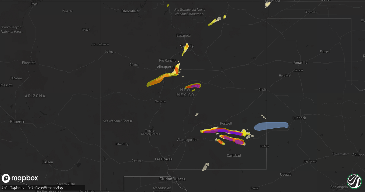
Hail Map in New Mexico on June 2, 2019
Get this storm
June 2 map
$229
one time, instant access
Download today. No call, no setup
Keep the $229
Bought the map and want the full workflow? Apply the entire $229 to a subscription within 7 days. None of it is wasted.
Every map, not just this one
This buys you this map. Subscription and you get every map we run, in the markets you choose from a few cities to whole states to nationwide. Plus real-time alerts the moment a storm fires.
Contact data
Name, contact info, occupancy, even credit band for addresses in the footprint. You go from where it hit to who to call.
Become the source they trust
Unlimited branding weather history reports on demand. You already have the documented answer ready for the property owner, and you are the one who showed up with it.
Property data and RoofTrace estimates
Pull up any address you have got, its value and the exact code rules for that jurisdiction, straight from One Click Code. Then RoofTrace estimates the squares, pitch, and roof value, priced the way you price.
Storm reports in New Mexico
New Mexico
| Date | Description |
|---|---|
| 06/02/20196:35 PM CDT | A local report indicates 65 MPH wind near STANLEY |
| 06/02/20196:30 PM CDT | A local report indicates 1.50 inch wind near SANTA FE |
| 06/02/20196:25 PM CDT | A local report indicates 1.00 inch wind near 2 ESE AGUA FRIA |
| 06/02/20196:18 PM CDT | A local report indicates 1.00 inch wind near 1 S SANTA FE |
| 06/02/20196:11 PM CDT | A local report indicates 1.75 inch wind near 6 SW HAGERMAN |
| 06/02/20195:59 PM CDT | A local report indicates 1.00 inch wind near PHILMONT SCOUT RANCH |
| 06/02/20195:45 PM CDT | Reported by storm spotter at us 285 and state rd. 559 intersection |
| 06/02/20195:45 PM CDT | A local report indicates 1.00 inch wind near 3 SE LOS CERRILLOS |
| 06/02/20195:45 PM CDT | A local report indicates 1.00 inch wind near 3 NNE LOS CERRILLOS |
| 06/02/20195:43 PM CDT | A local report indicates 1.00 inch wind near 4 E SANDIA PARK |
| 06/02/20195:36 PM CDT | Elevation 7228. |
| 06/02/20195:30 PM CDT | A local report indicates 1.75 inch wind near 1 WSW SEDILLO |
| 06/02/20195:27 PM CDT | A local report indicates 1.00 inch wind near 2 NW EDGEWOOD |
| 06/02/20195:25 PM CDT | A local report indicates 1.50 inch wind near 8 SSE TIJERAS |
| 06/02/20195:25 PM CDT | A local report indicates 1.00 inch wind near 1 S SANTA FE |
| 06/02/20195:20 PM CDT | 2 miles south of the colfax tavern. |
| 06/02/20195:20 PM CDT | A local report indicates 1.75 inch wind near 1 S PONDEROSA |
| 06/02/20195:00 PM CDT | A local report indicates 1.75 inch wind near 25 SW ROSWELL |
| 06/02/20195:00 PM CDT | A local report indicates 1.50 inch wind near LOS LUNAS |
| 06/02/20194:10 PM CDT | A local report indicates 1.00 inch wind near 1 SSW PHILMONT SCOUT RA |
| 06/02/20192:30 PM CDT | A local report indicates 1.00 inch wind near CHAMA |
| 06/02/20195:45 AM CDT | At 1045 PM CDT/945 PM MDT/, a severe thunderstorm was located 9 miles northwest of Seminole, moving east at 50 mph. HAZARD...60 mph wind gusts and quarter size hail. SOURCE...Radar indicated. IMPACT...Hail damage to vehicles is expected. Expect wind damage to roofs, siding, and trees. Locations impacted include... Hobbs, Seminole, Seagraves, Nadine, Seagraves Airport, Gaines County Airport, Loop, Knowles, Paynes Corner, Higginbotham, McKenzie Lake and Gaines County Park. |
| 06/02/20193:07 AM CDT | At 806 PM MDT, a severe thunderstorm was located near Dunken, or 25 miles west of Hope, moving northeast at 30 mph. HAZARD...60 mph wind gusts and quarter size hail. SOURCE...Radar indicated. IMPACT...Hail damage to vehicles is expected. Expect wind damage to roofs, siding, and trees. Locations impacted include... Dunken, US Highway 82, NM Highway 24, and NM Highway 13. |
| 06/02/20192:56 AM CDT | At 756 PM MDT, a severe thunderstorm was located 9 miles southwest of Maljamar, or 31 miles east of Artesia, moving east at 25 mph. HAZARD...Ping pong ball size hail and 60 mph wind gusts. SOURCE...Radar indicated. IMPACT...People and animals outdoors will be injured. Expect hail damage to roofs, siding, windows, and vehicles. Expect wind damage to roofs, siding, and trees. Locations impacted include... Maljamar, Lea County Zip Franklin Memorial Airport, Halfway and Loco Hills. |
| 06/02/20192:42 AM CDT | At 741 PM MDT, a severe thunderstorm was located 10 miles east of Dunken, or 17 miles west of Hope, moving north at 55 mph. HAZARD...60 mph wind gusts and half dollar size hail. SOURCE...Radar indicated. IMPACT...Hail damage to vehicles is expected. Expect wind damage to roofs, siding, and trees. This severe thunderstorm will remain over mainly rural areas of southeastern Lincoln and southwestern Chaves Counties. This includes US Highway 82 and NM Highway 13. |
| 06/02/20192:15 AM CDT | At 715 PM MDT, a severe thunderstorm was located 5 miles northwest of Lincoln National Forest, moving northeast at 50 mph. HAZARD...Two inch hail and 60 mph wind gusts. SOURCE...Radar indicated. IMPACT...People and animals outdoors will be injured. Expect hail damage to roofs, siding, windows, and vehicles. Expect wind damage to roofs, siding, and trees. Locations impacted include... Lincoln National Forest and Crow Flats. |
| 06/02/20191:57 AM CDT | At 655 PM MDT, a severe thunderstorm was located 7 miles northwest of Hope, moving east at 25 mph. HAZARD...60 mph wind gusts and half dollar size hail. SOURCE...Radar indicated. IMPACT...Hail damage to vehicles is expected. Expect wind damage to roofs, siding, and trees. Locations impacted include... Hope, Seven Rivers Airport, Brantley Lake State Park and Artesia Municipal Airport. |
| 06/02/20191:47 AM CDT | At 646 PM MDT, a severe thunderstorm was located 13 miles west of Lovington, moving east at 25 mph. HAZARD...60 mph wind gusts and half dollar size hail. SOURCE...Radar indicated. IMPACT...Hail damage to vehicles is expected. Expect wind damage to roofs, siding, and trees. Locations impacted include... Hobbs, Lovington, Tatum, McDonald, Humble City, Knowles, Gladiola and Tatum Airport. |
| 06/02/20191:24 AM CDT | At 623 PM MDT, a severe thunderstorm was located 19 miles north of Loco Hills, or 32 miles northeast of Artesia, moving east at 25 mph. This is a very dangerous storm. HAZARD...Three inch hail and 70 mph wind gusts. SOURCE...Radar indicated. IMPACT...People and animals outdoors will be severely injured. Expect shattered windows, extensive damage to roofs, siding, and vehicles. This severe thunderstorm will remain over mainly rural areas of east central Chaves County including Highay 249 and Highway 172. |
| 06/02/20191:03 AM CDT | At 603 PM MDT, a severe thunderstorm was located 10 miles northeast of Hope, moving east at 25 mph. HAZARD...60 mph wind gusts and quarter size hail. SOURCE...Radar indicated. IMPACT...Hail damage to vehicles is expected. Expect wind damage to roofs, siding, and trees. Locations impacted include... Artesia, Artesia Municipal Airport and Atoka. |
| 06/02/201912:58 AM CDT | At 556 PM MDT, a severe thunderstorm was located 6 miles southeast of Cornudas, moving northeast at 40 mph. HAZARD...60 mph wind gusts and half dollar size hail. SOURCE...Radar indicated. IMPACT...Hail damage to vehicles is expected. Expect wind damage to roofs, siding, and trees. Locations impacted include... Dell City, Cornudas, Salt Flat, Guadalupe Mountains National Park, Cornudas Mountains, Far Western Portions of Guadalupe Mountains National Park, Gypsum Dunes at Guadalupe National Park, and US Highway 62/180 between Cornudas and mile marker 100. |
| 06/02/201912:54 AM CDT | At 553 PM MDT, a severe thunderstorm was located 14 miles north of Hope, moving east at 25 mph. HAZARD...60 mph wind gusts and quarter size hail. SOURCE...Radar indicated. IMPACT...Hail damage to vehicles is expected. Expect wind damage to roofs, siding, and trees. Locations impacted include... Lake Arthur and Roswell Correctional Facility. This includes Highway 285 between Mile Markers 79 and 92. |
| 06/02/201912:33 AM CDT | At 533 PM MDT, a severe thunderstorm was located near Cochiti Pueblo, or 21 miles west of Santa Fe, moving northeast at 10 mph. HAZARD...60 mph wind gusts and quarter size hail. SOURCE...Radar indicated. IMPACT...Hail damage to vehicles is expected. Expect wind damage to roofs, siding, and trees. Locations impacted include... Santo Domingo Pueblo, Cochiti Pueblo, La Bajada, Cochiti Lake, Domingo, Pena Blanca and La Cienega. |
| 06/02/201912:25 AM CDT | At 524 PM MDT, a severe thunderstorm was located near Hagerman, or 21 miles southeast of Roswell, moving east at 25 mph. This is a very dangerous storm. HAZARD...Three inch hail and 70 mph wind gusts. SOURCE...Radar indicated. IMPACT...People and animals outdoors will be severely injured. Expect shattered windows, extensive damage to roofs, siding, and vehicles. Locations impacted include... Dexter, Hagerman, Lake Arthur and Greenfield. This includes Highway 249 and Highway 172. |
| 06/02/201912:24 AM CDT | At 524 PM MDT, a severe thunderstorm was located over eastern Santa Fe, moving northeast at 35 mph. HAZARD...60 mph wind gusts and quarter size hail. SOURCE...Radar indicated. IMPACT...Hail damage to vehicles is expected. Expect wind damage to roofs, siding, and trees. Locations impacted include... Santa Fe, Cundiyo, Canada De Los Alamos, Cowles, Rio Chiquito, Hyde Memorial State Park, Rio En Medio in Santa Fe County, Tesuque, Cordova and Chupadero.This includes Interstate 25 between Mile Markers 278 and 288. |
| 06/01/201911:41 PM CDT | At 441 PM MDT, a severe thunderstorm was located over Cedarvale, or 9 miles northwest of Corona, moving east at 20 mph. This is a very dangerous storm. HAZARD...80 mph wind gusts and half dollar size hail. SOURCE...Radar indicated. IMPACT...Flying debris will be dangerous to those caught without shelter. Mobile homes will be heavily damaged. Expect considerable damage to roofs, windows, and vehicles. Extensive tree damage and power outages are likely. Locations impacted include... Cedarvale. |
| 06/01/201911:36 PM CDT | At 436 PM MDT, a severe thunderstorm was located near Dexter, or 16 miles south of Roswell, moving east at 30 mph. This is a very dangerous storm. HAZARD...80 mph wind gusts and two inch hail. SOURCE...Radar indicated. IMPACT...Flying debris will be dangerous to those caught without shelter. Mobile homes will be heavily damaged. Expect considerable damage to roofs, windows, and vehicles. Extensive tree damage and power outages are likely. Locations impacted include... Dexter, Hagerman, Lake Arthur, Greenfield and Roswell Correctional Facility.This includes Highway 285 between Mile Markers 79 and 99. |
| 06/01/201911:30 PM CDT | At 430 PM MDT, a severe thunderstorm was located near Escabosa, or 19 miles west of Estancia, moving east at 30 mph. HAZARD...Ping pong ball size hail and 60 mph wind gusts. SOURCE...Radar indicated. IMPACT...People and animals outdoors will be injured. Expect hail damage to roofs, siding, windows, and vehicles. Expect wind damage to roofs, siding, and trees. Locations impacted include... Escabosa, Torreon, Tajique, Chilili, Ponderosa Pines, Miera and Meadow Lake. |
| 06/01/201911:20 PM CDT | At 420 PM MDT, a severe thunderstorm was located near Escabosa, or 13 miles west of Moriarty, moving north at 30 mph. HAZARD...60 mph wind gusts and quarter size hail. SOURCE...Radar indicated. IMPACT...Hail damage to vehicles is expected. Expect wind damage to roofs, siding, and trees. Locations impacted include... Edgewood, Tijeras, Cedar Crest, Cedar Grove, Sedillo, Madrid, Galisteo, Golden, Cedro and Ponderosa Pines.This includes the following highways... Interstate 40 between Mile Markers 175 and 192. Highway 285 between Mile Markers 276 and 279. |
| 06/01/201910:58 PM CDT | At 357 PM MDT, a severe thunderstorm was located over Maxwell, or 10 miles north of Springer, moving east at 25 mph. HAZARD...60 mph wind gusts and quarter size hail. SOURCE...Radar indicated. IMPACT...Hail damage to vehicles is expected. Expect wind damage to roofs, siding, and trees. Locations impacted include... Maxwell and Raton Crews Airport. This includes Interstate 25 between Mile Markers 416 and 442. |
| 06/01/201910:51 PM CDT | At 351 PM MDT, a severe thunderstorm was located over Los Lunas, moving northeast at 20 mph. HAZARD...60 mph wind gusts and quarter size hail. SOURCE...Radar indicated. IMPACT...Hail damage to vehicles is expected. Expect wind damage to roofs, siding, and trees. Locations impacted include... Valencia, Los Lunas, Belen, Bosque Farms, Peralta, Rio Communities North, Isleta Pueblo, El Cerro Mission, Los Trujillos-Gabaldon and Tome.This includes Interstate 25 between Mile Markers 192 and 211. |
| 06/01/201910:10 PM CDT | At 310 PM MDT, a severe thunderstorm was located 16 miles west of Belen, moving east at 15 mph. HAZARD...Ping pong ball size hail and 60 mph wind gusts. SOURCE...Radar indicated. IMPACT...People and animals outdoors will be injured. Expect hail damage to roofs, siding, windows, and vehicles. Expect wind damage to roofs, siding, and trees. Locations impacted include... Belen, Casa Colorada, Jarales, Los Trujillos-Gabaldon and Los Chaves.This includes Interstate 25 between Mile Markers 183 and 197. |
| 06/01/20199:59 PM CDT | At 259 PM MDT, a severe thunderstorm was located 16 miles southeast of Tinnie, or 30 miles west of Roswell, moving east at 15 mph. This is a very dangerous storm. HAZARD...80 mph wind gusts and tennis ball size hail. SOURCE...Radar indicated. IMPACT...Flying debris will be dangerous to those caught without shelter. Mobile homes will be heavily damaged. Expect considerable damage to roofs, windows, and vehicles. Extensive tree damage and power outages are likely. This severe thunderstorm will remain over mainly rural areas of southeastern Lincoln and west central Chaves Counties. |
| 06/01/20199:43 PM CDT | At 243 PM MDT, a severe thunderstorm was located 9 miles south of Encino, or 16 miles west of Vaughn, moving east at 15 mph. This is a very dangerous storm. HAZARD...80 mph wind gusts and three inch hail. SOURCE...Radar indicated. IMPACT...Flying debris will be dangerous to those caught without shelter. Mobile homes will be heavily damaged. Expect considerable damage to roofs, windows, and vehicles. Extensive tree damage and power outages are likely. Locations impacted include... Vaughn and Duran. This includes Highway 285 near Mile Marker 204. |
| 06/01/20199:23 PM CDT | At 222 PM MDT, a severe thunderstorm was located 10 miles east of Black Lake, or 26 miles west of Springer, moving northeast at 20 mph. HAZARD...60 mph wind gusts and quarter size hail. SOURCE...Radar indicated. IMPACT...Hail damage to vehicles is expected. Expect wind damage to roofs, siding, and trees. Locations impacted include... Angel Fire, Cimarron, Black Lake, Philmont Scout Ranch, Rayado and Miami. |
| 06/01/20199:17 PM CDT | At 216 PM MDT, a severe thunderstorm was located 26 miles southeast of Acoma Pueblo, or 31 miles west of Belen, moving northeast at 15 mph. HAZARD...60 mph wind gusts and quarter size hail. SOURCE...Radar indicated. IMPACT...Hail damage to vehicles is expected. Expect wind damage to roofs, siding, and trees. This severe thunderstorm will remain over mainly rural areas of southeastern Cibola...west central Valencia and north central Socorro Counties. |
| 06/01/20199:09 PM CDT | At 209 PM MDT, a severe thunderstorm was located 12 miles northeast of Elk Silver, moving northeast at 15 mph. HAZARD...60 mph wind gusts and half dollar size hail. SOURCE...Radar indicated. IMPACT...Hail damage to vehicles is expected. Expect wind damage to roofs, siding, and trees. This severe thunderstorm will remain over mainly rural areas of north central Otero County. |
| 06/01/20199:06 PM CDT | At 206 PM MDT, a severe thunderstorm was located 13 miles northeast of Elk Silver, or 23 miles southeast of Ruidoso, moving east at 10 mph. HAZARD...Ping pong ball size hail and 60 mph wind gusts. SOURCE...Radar indicated. IMPACT...People and animals outdoors will be injured. Expect hail damage to roofs, siding, windows, and vehicles. Expect wind damage to roofs, siding, and trees. This severe thunderstorm will remain over mainly rural areas of southeastern Lincoln and west central Chaves Counties. |
| 06/01/20199:05 PM CDT | A local report indicates 58 MPH wind near TATUM |
| 06/01/20199:05 PM CDT | A local report indicates 58 MPH wind near 2 SW TATUM |
| 06/01/20198:23 PM CDT | At 123 PM MDT, a severe thunderstorm was located 11 miles southeast of Willard, or 20 miles southeast of Estancia, moving northeast at 25 mph. HAZARD...60 mph wind gusts and quarter size hail. SOURCE...Radar indicated. IMPACT...Hail damage to vehicles is expected. Expect wind damage to roofs, siding, and trees. This severe thunderstorm will remain over mainly rural areas of southeastern Torrance County. |
| 06/01/20198:15 PM CDT | A local report indicates 1.25 inch wind near HOPE |
| 06/01/20197:41 PM CDT | A local report indicates 61 MPH wind near 3 W ARTESIA |
All States Impacted by Hail Map on June 2, 2019
Cities Impacted by Hail Map on June 2, 2019
- Ripley, WV
- Cream Ridge, NJ
- Hope, NM
- Artesia, NM
- Fayetteville, AR
- Springdale, AR
- Gainesville, VA
- Glen Echo, MD
- McLean, VA
- Chevy Chase, MD
- Washington, DC
- Bethesda, MD
- Santa Fe, NM
- Salem, WV
- Clarksburg, WV
- West Union, WV
- New Milton, WV
- Roswell, NM
- Ceredo, WV
- Ashland, KY
- Huntington, WV
- Catlettsburg, KY
- Kenova, WV
- South Point, OH
- Hagerman, NM
- Lovington, NM
- Tinnie, NM
- Dexter, NM
- Harts, WV
- West Chester, PA
- Delaplane, VA
- Markham, VA
- Tijeras, NM
- Given, WV
- Lake Arthur, NM
- Clear Spring, MD
- Big Pool, MD
- Marlinton, WV
- The Plains, VA
- Jacksonburg, WV
- Alma, WV
- Chapmanville, WV
- Hermosa, SD
- Rapid City, SD
- Black Hawk, SD
- Fairburn, SD
- Buffalo Gap, SD
- Keystone, SD
- Orma, WV
- Arnoldsburg, WV
- Mount Zion, WV
- Grantsville, WV
- Normantown, WV
- Millstone, WV
- Goodwell, OK
- Harrisville, WV
- Smithville, WV
- Medora, ND
- Oakland, MD
- Lowell, AR
- Rogers, AR
- Wilmington, DE
- Mineral Wells, WV
- Elizabeth, WV
- Sandia Park, NM
- Peralta, NM
- Edgewood, NM
- Raton, NM
- Saint Paul, NE
- Bladensburg, MD
- Arlington, VA
- Brentwood, MD
- Potomac, MD
- Rockville, MD
- Kensington, MD
- Garrett Park, MD
- Silver Spring, MD
- Hyattsville, MD
- Derwood, MD
- Great Falls, VA
- Spencerville, MD
- Mount Rainier, MD
- Cabin John, MD
- Gaithersburg, MD
- Clarksburg, MD
- Germantown, MD
- Ijamsville, MD
- Damascus, MD
- Kimball, NE
- Bosque Farms, NM
- Los Lunas, NM
- Belen, NM
- Maxwell, NM
- Cimarron, NM
- Bowman, ND
- Rhame, ND
- Amidon, ND
- Vincentown, NJ
- Yoder, WY
- Guernsey, WY
- Wheatland, WY
- Robeline, LA
- Coushatta, LA
- Marthaville, LA
- Pedro, OH
- Ironton, OH
- Franklin Furnace, OH
- Walker, WV
- Scottown, OH
- Willow Wood, OH
- Pine Bluffs, WY
- Shawnee, WY
- Greenup, KY
- Columbus, NJ
- Friendsville, MD
- Terra Alta, WV
- McHenry, MD
- Sharpsburg, MD
- Rohrersville, MD
- Keedysville, MD
- Knoxville, MD
- Marshall, VA
- Linden, VA
- Front Royal, VA
- Upperville, VA
- Campo, CO
- Boise City, OK
- Kenton, OK
- Upper Tract, WV
- Cabins, WV
- Marathon, TX
- Philippi, WV
- Moatsville, WV
- Rowlesburg, WV
- Eglon, WV
- Gormania, WV
- Tunnelton, WV
- Aurora, WV
- Grenville, NM
- Spencer, WV
- Seminole, TX
- Elmer, NJ
- Dryfork, WV
- Davis, WV
- Parsons, WV
- Red Creek, WV
- Hambleton, WV
- Hendricks, WV
- Crawford, NE
- Cheyenne, WY
- Sterling, VA
- Milnesand, NM
- Burlington, NJ
- Shenandoah Junction, WV
- Brunswick, MD
- Kearneysville, WV
- Lovettsville, VA
- Point Of Rocks, MD
- Harpers Ferry, WV
- Jefferson, MD
- King George, VA
- Saint Francis, KS
- Mount Airy, MD
- Brookeville, MD
- Monrovia, MD
- Ulysses, KS
- Satanta, KS
- Ashburn, VA
- Herndon, VA
- Williamson, WV
- Belfry, KY
- Martinsburg, WV
- Shepherdstown, WV
- Leland, NC
- Valentine, TX
- Martin, SD
- Manassas, VA
- Nokesville, VA
- Bristow, VA
- Sentinel Butte, ND
- Douglas, WY
- Hertford, NC
- Malvern, PA
- Phoenixville, PA
- Eads, CO
- Kenna, WV
- Liberty, WV
- Bordentown, NJ
- Mount Holly, NJ
- Kermit, WV
- Crum, WV
- Lenore, WV
- Dunlow, WV
- Warfield, KY
- Dingess, WV
- Breeden, WV
- Lovely, KY
- Wilsondale, WV
- Genoa, WV
- Fort Gay, WV
- Shock, WV
- Catlett, VA
- Warrenton, VA
- Tuthill, SD
- Dover, DE
- Cheswold, DE
- Troy, WV
- Columbia, MD
- Fulton, MD
- Ashton, MD
- Laurel, MD
- Lincoln University, PA
- Oxford, PA
- West Grove, PA
- Webster Springs, WV
- Diana, WV
- Hacker Valley, WV
- Cowen, WV
- Sutton, WV
- Pocomoke City, MD
- Palestine, WV
- Columbia, NC
- Lancaster, PA
- Willow Street, PA
- Nemo, SD
- Piedmont, SD
- Munday, WV
- Springer, NM
- Flemington, WV
- Chester Gap, VA
- Hume, VA
- Flint Hill, VA
- Huntly, VA
- Cerrillos, NM
- Bushnell, NE
- Poolesville, MD
- Boyds, MD
- Cody, NE
- Weston, WV
- Jane Lew, WV
- Kitts Hill, OH
- Chesapeake, OH
- Burnsville, WV
- Linn, WV
- Carpenter, WY
- Burns, WY
- Elk Garden, WV
- Mount Storm, WV
- Crookston, NE
- Harrisburg, NE
- Dickerson, MD
- Jarales, NM
- Laguna, NM
- Delbarton, WV
- Golva, ND
- Dell City, TX
- East Lynn, WV
- Ranger, WV
- Branchland, WV
- Mercersburg, PA
- Haswell, CO
- Kilgore, NE
- Saint Francis, SD
- Accident, MD
- Swanton, MD
- Birch River, WV
- Rosedale, WV
- Gassaway, WV
- Cheyney, PA
- Glen Mills, PA
- Thornton, PA
- Little Birch, WV
- Forest Hills, KY
- Hardy, KY
- McCarr, KY
- Alpine, TX
- Glenville, WV
- Camden, WV
- Estancia, NM
- Brooklyn, NY
- Aldie, VA
- Belleville, WV
- Ravenswood, WV
- Rockport, WV
- Majestic, KY
- Hurley, VA
- Matewan, WV
- Stopover, KY
- Elkins, AR
- Lavalette, WV
- Barboursville, WV
- Wayne, WV
- Paden City, WV
- New Martinsville, WV
- Sardis, OH
- Fort Davis, TX
- Marfa, TX
- Nenzel, NE
- Chadron, NE
- Newburg, WV
- Kingwood, WV
- Wesley, AR
- Wanblee, SD
- Harrison, NE
- Whitney, NE
- Princess Anne, MD
- Elizabeth City, NC
- Wheelersburg, OH
- Salt Flat, TX
- Kadoka, SD
- White River, SD
- Long Valley, SD
- Annapolis Junction, MD
- Jessup, MD
- Hanover, MD
- Fort George G Meade, MD
- Severn, MD
- Colorado Springs, CO
- Medford, NJ
- Wasco, CA
- Capitan, NM
- Quantico, VA
- Auburn, WV
- Deadwood, SD
- Leesburg, VA
- Pennsboro, WV
- Allen, SD
- Montgomery Village, MD
- Sidney, NE
- Gardners, PA
- Arlington, CO
- Woodsfield, OH
- Montrose, WV
- Prichard, WV
- Cloudcroft, NM
- Bridgeton, NJ
- Wilmington, NC
- Frederick, MD
- Manville, WY
- Coxs Mills, WV
- Alum Bridge, WV
- Petroleum, WV
- Evans, WV
- Leon, WV
- Woodbridge, VA
- Worthington, KY
- Tatum, NM
- Sandy Spring, MD
- Olney, MD
- Hay Springs, NE
- Creston, WV
- Moriarty, NM
- Thomas, WV
- French Creek, WV
- Freeburn, KY
- South Williamson, KY
- Jeffersonton, VA
- Encino, NM
- Bridgeport, WV
- Kitzmiller, MD
- Amissville, VA
- Patriot, OH
- Coatesville, PA
- Kennett Square, PA
- Cottageville, WV
- Vienna, VA
- Grafton, WV
- Berkeley Springs, WV
- Fort Hancock, TX
- Broken Bow, NE
- Felt, OK
- Rushville, NE
- Merchantville, NJ
- Pennsauken, NJ
- Cubero, NM
- Mount Joy, PA
- Landisville, PA
- Manheim, PA
- Parkersburg, WV
- Washington, WV
- Reedy, WV
- Narvon, PA
- Stevens, PA
- Ephrata, PA
- Denver, PA
- New Holland, PA
- Calhan, CO
- Middleburg, VA
- Fort Laramie, WY
- Takoma Park, MD
- Riverdale, MD
- Beltsville, MD
- Burtonsville, MD
- Capitol Heights, MD
- Brinklow, MD
- Washington Grove, MD
- Highland, MD
- Clarksville, MD
- Dayton, MD
- Calabash, NC
- Ash, NC
- Holden, WV
- Center Point, WV
- Yoder, CO
- Falls Church, VA
- Kerens, WV
- Dunn Loring, VA
- Coalinga, CA
- Sugar City, CO
- Big Bend National Park, TX
- Crown City, OH
- Boyce, VA
- Big Springs, WV
- Graysville, OH
- Keyser, WV
- New Creek, WV
- Dix, NE
- Willard, NM
- Tierra Amarilla, NM
- Chama, NM
- Mayhill, NM
- Sistersville, WV
- Purcellville, VA
- Charles Town, WV
- Harman, WV
- Bowden, WV
- Kiahsville, WV
- Bentonville, VA
- Caputa, SD
- Pine Ridge, SD
- Belvidere, SD
- Norris, SD
- Ocean Isle Beach, NC
- Sunset Beach, NC
- Longwood, NC
- Merriman, NE
- Chesterfield, NJ
- Freehold, NJ
- Jackson, NJ
- New Egypt, NJ
- Millstone Township, NJ
- Allentown, NJ
- West Creek, NJ
- Manahawkin, NJ
- Beach Haven, NJ
- Millersville, PA
- Strasburg, PA
- Pedricktown, NJ
- Penns Grove, NJ
- Woodstown, NJ
- Alloway, NJ
- Salem, NJ
- Sierra Blanca, TX
- Wall, TX
- San Angelo, TX
- Morton, TX
- Whiteface, TX
- Tokio, TX
- Meadow, TX
- Levelland, TX
- Plains, TX
- Ropesville, TX
- Weston, CO
- Las Animas, CO
- Glendo, WY


