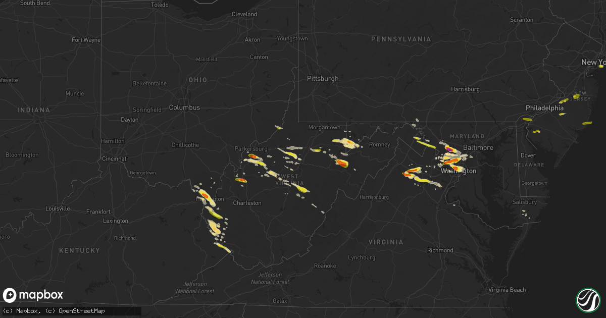
Hail Map in West Virginia on June 2, 2019
Get this storm
June 2 map
$229
one time, instant access
Download today. No call, no setup
Keep the $229
Bought the map and want the full workflow? Apply the entire $229 to a subscription within 7 days. None of it is wasted.
Every map, not just this one
This buys you this map. Subscription and you get every map we run, in the markets you choose from a few cities to whole states to nationwide. Plus real-time alerts the moment a storm fires.
Contact data
Name, contact info, occupancy, even credit band for addresses in the footprint. You go from where it hit to who to call.
Become the source they trust
Unlimited branding weather history reports on demand. You already have the documented answer ready for the property owner, and you are the one who showed up with it.
Property data and RoofTrace estimates
Pull up any address you have got, its value and the exact code rules for that jurisdiction, straight from One Click Code. Then RoofTrace estimates the squares, pitch, and roof value, priced the way you price.
Storm reports in West Virginia
West Virginia
| Date | Description |
|---|---|
| 06/02/20195:37 PM CDT | Public report via broadcast media twitter with picture |
| 06/02/20195:24 PM CDT | Still occuring at time of call |
| 06/02/20193:28 PM CDT | Hail ongoing |
| 06/02/20192:36 PM CDT | 2 trees downed due to high wind on 6 mile road. |
| 06/02/20192:11 PM CDT | One tree downed on wilson creek due to high wind. |
| 06/02/20192:11 PM CDT | One tree downed at the save a lot due to high wind. |
| 06/02/20192:10 PM CDT | A local report indicates 1.00 inch wind near 2 ENE RED CREEK |
| 06/02/20192:09 PM CDT | A local report indicates 1.00 inch wind near 1 E RED CREEK |
| 06/02/20192:05 PM CDT | The 911 center in wayne county reported a hail size of a quarter. |
| 06/02/20192:04 PM CDT | Nickel to golf ball sized hail at canaan valley state park resort. |
| 06/02/20192:03 PM CDT | Put dent in cars. |
| 06/02/20192:00 PM CDT | A local report indicates 1.00 inch wind near 1 ENE MOUNT ZION |
| 06/02/20191:37 PM CDT | A local report indicates 1.00 inch wind near 2 NE TUNNELTON |
| 06/02/20191:34 PM CDT | Tree down on fisher bowen branch road just outside of beech fork state park. Time estimated from radar. |
| 06/02/20191:33 PM CDT | Updated for increased hail size reported after first call |
| 06/02/20191:31 PM CDT | A local report indicates 1.00 inch wind near 1 SSE FAIRPLAIN |
| 06/02/20191:24 PM CDT | Via twitter with photo |
| 06/02/20191:20 PM CDT | Via facebook private message with picture |
| 06/02/20191:15 PM CDT | A local report indicates 1.00 inch wind near 1 SW SHEPHERDSTOWN |
| 06/02/20191:15 PM CDT | Via facebook private message. |
| 06/02/20191:05 PM CDT | Corrects time for previous hail report from 2 wsw huntington. Hail size of a quarter was reported at a museum in huntington. |
| 06/02/20191:04 PM CDT | Delayed report. Pictures submitted from broadcast media of large hail near coldwater and new milton. |
| 06/02/20191:01 PM CDT | Downed tree due to high wind on state rt. 5. |
| 06/02/20191:00 PM CDT | Via twitter with pictures. Time estimated via radar. |
| 06/02/201912:58 PM CDT | A local report indicates 1.00 inch wind near 2 SE MARTINSBURG |
| 06/02/201912:58 PM CDT | A local report indicates 1.00 inch wind near 2 WNW WINEBRENNERS CROS |
| 06/02/20191:05 AM CDT | Hail size of a quarter was reported at a museum in huntington. |
| 06/02/201912:07 AM CDT | At 507 PM EDT, a severe thunderstorm was located over Bandy, moving southeast at 30 mph. HAZARD...60 mph wind gusts and quarter size hail. SOURCE...Radar indicated. IMPACT...Hail damage to vehicles is expected. Expect wind damage to roofs, siding, and trees. Locations impacted include... Richlands... Tazewell... Cedar Bluff... Amonate... and Claypool Hill. |
| 06/01/201911:41 PM CDT | At 441 PM EDT, a severe thunderstorm was located 7 miles northeast of Addison (Webster Springs), or 7 miles east of Webster Springs, moving southeast at 20 mph. HAZARD...60 mph wind gusts and quarter size hail. SOURCE...Radar indicated. IMPACT...Hail damage to vehicles is expected. Expect wind damage to roofs, siding, and trees. Locations impacted include... Webster Springs, Addison (Webster Springs), Snowshoe, Mingo, Edray, Monterville, Slaty Fork, Bergoo and Waneta. |
| 06/01/201911:18 PM CDT | At 418 PM EDT, a severe thunderstorm was located near Webster Springs, moving southeast at 25 mph. HAZARD...60 mph wind gusts and quarter size hail. SOURCE...Radar indicated. IMPACT...Hail damage to vehicles is expected. Expect wind damage to roofs, siding, and trees. Locations impacted include... Webster Springs, Addison (Webster Springs), Diana, Monterville, Hacker Valley, Bergoo and Waneta. |
| 06/01/201911:11 PM CDT | At 411 PM EDT, a severe thunderstorm was located near Woodman, or 16 miles northeast of Grundy, moving southeast at 30 mph. HAZARD...60 mph wind gusts and quarter size hail. SOURCE...Radar indicated. IMPACT...Hail damage to vehicles is expected. Expect wind damage to roofs, siding, and trees. Locations impacted include... Welch, War, Gilbert Creek, Davy, Bradshaw, Iaeger, Panther, Coalwood, Hurley, Avondale and Jolo. |
| 06/01/201910:45 PM CDT | At 345 PM EDT, a severe thunderstorm was located 8 miles southwest of Claylick, or 9 miles east of Hancock, moving east at 15 mph. HAZARD...60 mph wind gusts and half dollar size hail. SOURCE...Radar indicated. IMPACT...Damaging winds will cause some trees and large branches to fall. This could injure those outdoors, as well as damage homes and vehicles. Roadways may become blocked by downed trees. Localized power outages are possible. Unsecured light objects may become projectiles. Locations impacted include... Hagerstown, Fountainhead-Orchard Hills, Wilson-Conococheague, Williamsport, Long Meadow, Saint James, Halfway, Maugansville, Falling Waters, Clear Spring, Hedgesville, Pecktonville, Big Spring, Big Pool, Middleburg, Johnsontown, Warrenton and Sleepy Creek. |
| 06/01/201910:29 PM CDT | At 328 PM EDT, a severe thunderstorm was located 10 miles northeast of Philippi, moving east at 35 mph. HAZARD...Wind gusts to 60 mph and half dollar-size hail. SOURCE...Radar. IMPACT...Minor hail damage to vehicles is possible. Expect wind damage to trees and power lines, resulting in some power outages. Locations impacted include... Parsons... Thomas... Hannahsville... Silver Lake... Benbush... Lead Mine... Pifer Moutain... Saint George... Israel... Elgon... |
| 06/01/201910:28 PM CDT | At 328 PM EDT, a severe thunderstorm was located over Gill, or 14 miles south of Hamlin, moving southeast at 25 mph. HAZARD...60 mph wind gusts and quarter size hail. SOURCE...Radar indicated. IMPACT...Hail damage to vehicles is expected. Expect wind damage to roofs, siding, and trees. Locations impacted include... Madison, Logan, Chapmanville, Chief Logan State, Ranger, Gill, Harts, Mount Gay-Shamrock, West Logan, Mitchell Heights, Mount Gay, Turtle Creek and Mud.This includes Route 119 between mile markers 28 and 50. |
| 06/01/20199:56 PM CDT | At 255 PM EDT, a severe thunderstorm was located near Hendricks, or near Parsons, moving southeast at 25 mph. HAZARD...60 mph wind gusts and quarter size hail. SOURCE...Radar indicated. IMPACT...Damaging winds will cause some trees and large branches to fall. This could injure those outdoors, as well as damage homes and vehicles. Roadways may become blocked by downed trees. Localized power outages are possible. Unsecured light objects may become projectiles. Locations impacted include... Petersburg, Upper Tract, Seneca Rocks, Onego, Cabins, Landes, Hopeville and Brushy Run. |
| 06/01/20199:54 PM CDT | At 254 PM EDT, a severe thunderstorm was located over Hendricks, or near Parsons, moving southeast at 20 mph. HAZARD...Wind gusts to 60 mph and quarter-size hail. SOURCE...Radar. IMPACT...Minor hail damage to vehicles is possible. Expect wind damage to trees and power lines, resulting in some power outages. Locations impacted include... Parsons... Davis... Hendricks... Hambleton... Elk... Canaan Valley State Park... Pheasant Run... Blackwater Falls... Davisville... Cortland... Laneville... Red Creek... |
| 06/01/20199:42 PM CDT | At 242 PM EDT, a severe thunderstorm was located near Barboursville, or near Beech Fork State Park, moving southeast at 20 mph. HAZARD...Ping pong ball size hail and 60 mph wind gusts. SOURCE...Radar indicated. IMPACT...People and animals outdoors will be injured. Expect hail damage to roofs, siding, windows, and vehicles. Expect wind damage to roofs, siding, and trees. Locations impacted include... Beech Fork State Park, Barboursville, Salt Rock, Pea Ridge and Lavalette.This includes Interstate 64 in West Virginia between mile markers 17and 21. |
| 06/01/20199:34 PM CDT | At 233 PM EDT, a severe thunderstorm was located near Kingwood, moving east at 25 mph. HAZARD...Wind gusts to 60 mph and quarter-size hail. SOURCE...Radar. IMPACT...Minor hail damage to vehicles is possible. Expect wind damage to trees and power lines, resulting in some power outages. Locations impacted include... Kingwood... Terra Alta... Rowlesburg... Albright... Tunnelton... |
| 06/01/20199:32 PM CDT | At 232 PM EDT, a severe thunderstorm was located near Kenna, or 7 miles south of Ripley, moving east at 25 mph. HAZARD...60 mph wind gusts and half dollar size hail. SOURCE...Radar indicated. IMPACT...Hail damage to vehicles is expected. Expect wind damage to roofs, siding, and trees. Locations impacted include... Kenna, Statts Mills, Harmony, Kentuck, Fairplain, Gay, Walton and Gandeeville.This includes Interstate 77 in West Virginia between mile markers 125and 134. |
| 06/01/20199:30 PM CDT | At 230 PM EDT, a severe thunderstorm was located near Shepherdstown, moving east at 10 mph. HAZARD...60 mph wind gusts and quarter size hail. SOURCE...Radar indicated. IMPACT...Damaging winds will cause some trees and large branches to fall. This could injure those outdoors, as well as damage homes and vehicles. Roadways may become blocked by downed trees. Localized power outages are possible. Unsecured light objects may become projectiles. Locations impacted include... Brunswick, Rosemont, Rohrersville, Burkittsville, Gapland, Brownsville, Antietam, Petersville, Arnoldtown, Moler Crossroads and Middletown In Frederick Md. |
| 06/01/20199:24 PM CDT | At 224 PM EDT, a severe thunderstorm was located near Grantsville, moving southeast at 25 mph. HAZARD...60 mph wind gusts and half dollar size hail. This storm is exhibiting rotation. SOURCE...Radar indicated. IMPACT...Hail damage to vehicles is expected. Expect wind damage to roofs, siding, and trees. Locations impacted include... Grantsville, Arnoldsburg, Cedar Creek State Park, Shock, Millstone, Rosedale, Mount Zion, Orma, Creston, Nicut, Stumptown, Annamoriah, Cedarville, Normantown and Munday. |
| 06/01/20199:18 PM CDT | At 218 PM EDT, a severe thunderstorm was located near Oakland, moving east at 20 mph. HAZARD...60 mph wind gusts and quarter size hail. SOURCE...Radar indicated. IMPACT...Damaging winds will cause some trees and large branches to fall. This could injure those outdoors, as well as damage homes and vehicles. Roadways may become blocked by downed trees. Localized power outages are possible. Unsecured light objects may become projectiles. Locations impacted include... Bayard, Elk Garden, Kitzmiller, Gorman, Sulphur City, Emoryville, Hartmansville, New Creek, Martin, Scherr, Mount Pisgah, Bismarck and Mount Storm. |
| 06/01/20199:11 PM CDT | At 210 PM EDT, a severe thunderstorm was located over Chesapeake, moving southeast at 20 mph. HAZARD...Ping pong ball size hail and 60 mph wind gusts. This storm is also exhibiting rotation. SOURCE...Radar indicated. IMPACT...People and animals outdoors will be injured. Expect hail damage to roofs, siding, windows, and vehicles. Expect wind damage to roofs, siding, and trees. Locations impacted include... Huntington, Chesapeake, Proctorville, Beech Fork State Park, Barboursville, Kenova, Milton, Ceredo, Ona, Culloden, South Point, Burlington, Lavalette, Salt Rock and Pea Ridge.This includes Interstate 64 in West Virginia between mile markers 3and 30. |
| 06/01/20199:08 PM CDT | At 208 PM EDT, a severe thunderstorm was located near Inwood, or near Greenwood, moving east at 25 mph. HAZARD...60 mph wind gusts and quarter size hail. SOURCE...Radar indicated. IMPACT...Damaging winds will cause some trees and large branches to fall. This could injure those outdoors, as well as damage homes and vehicles. Roadways may become blocked by downed trees. Localized power outages are possible. Unsecured light objects may become projectiles. Locations impacted include... Martinsburg, Charles Town, Ranson, Inwood, Kearneysville, Corporation Of Ranson, Shenandoah Junction, Winebrenners Cross, Arden, Shanghai, Vanville and Martinsburg Airport. |
| 06/01/20198:28 PM CDT | At 127 PM EDT, a severe thunderstorm was located near Bayard, moving east at 35 mph. HAZARD...60 mph wind gusts and quarter size hail. SOURCE...Radar indicated. IMPACT...Damaging winds will cause some trees and large branches to fall. This could injure those outdoors, as well as damage homes and vehicles. Roadways may become blocked by downed trees. Localized power outages are possible. Unsecured light objects may become projectiles. Locations impacted include... Bayard, Elk Garden, Kitzmiller, Burlington, Gorman, Russelldale, Old Fields, Sulphur City, Purgitsville, Emoryville, Hartmansville, New Creek, Martin, Scherr, Antioch, Medley, Williamsport, Mount Pisgah, Junction and Bismarck. |
| 06/01/20198:28 PM CDT | At 128 PM EDT, a severe thunderstorm was located near Mineralwells, or near Elizabeth, moving east at 25 mph. HAZARD...Ping pong ball size hail and 60 mph wind gusts. SOURCE...Radar indicated. IMPACT...People and animals outdoors will be injured. Expect hail damage to roofs, siding, windows, and vehicles. Expect wind damage to roofs, siding, and trees. Locations impacted include... Parkersburg, Harrisville, Elizabeth, Mineralwells, Lubeck, Cairo, Pullman, Cherry, Peewee, Smithville, Walker, Petroleum, Palestine, Lucille, Freeport, Davisville, Greencastle, Creston, Morristown and Rockport.This includes Interstate 77 in West Virginia between mile markers 156and 173. |
All States Impacted by Hail Map on June 2, 2019
Cities Impacted by Hail Map on June 2, 2019
- Ripley, WV
- Cream Ridge, NJ
- Hope, NM
- Artesia, NM
- Fayetteville, AR
- Springdale, AR
- Gainesville, VA
- Glen Echo, MD
- McLean, VA
- Chevy Chase, MD
- Washington, DC
- Bethesda, MD
- Santa Fe, NM
- Salem, WV
- Clarksburg, WV
- West Union, WV
- New Milton, WV
- Roswell, NM
- Ceredo, WV
- Ashland, KY
- Huntington, WV
- Catlettsburg, KY
- Kenova, WV
- South Point, OH
- Hagerman, NM
- Lovington, NM
- Tinnie, NM
- Dexter, NM
- Harts, WV
- West Chester, PA
- Delaplane, VA
- Markham, VA
- Tijeras, NM
- Given, WV
- Lake Arthur, NM
- Clear Spring, MD
- Big Pool, MD
- Marlinton, WV
- The Plains, VA
- Jacksonburg, WV
- Alma, WV
- Chapmanville, WV
- Hermosa, SD
- Rapid City, SD
- Black Hawk, SD
- Fairburn, SD
- Buffalo Gap, SD
- Keystone, SD
- Orma, WV
- Arnoldsburg, WV
- Mount Zion, WV
- Grantsville, WV
- Normantown, WV
- Millstone, WV
- Goodwell, OK
- Harrisville, WV
- Smithville, WV
- Medora, ND
- Oakland, MD
- Lowell, AR
- Rogers, AR
- Wilmington, DE
- Mineral Wells, WV
- Elizabeth, WV
- Sandia Park, NM
- Peralta, NM
- Edgewood, NM
- Raton, NM
- Saint Paul, NE
- Bladensburg, MD
- Arlington, VA
- Brentwood, MD
- Potomac, MD
- Rockville, MD
- Kensington, MD
- Garrett Park, MD
- Silver Spring, MD
- Hyattsville, MD
- Derwood, MD
- Great Falls, VA
- Spencerville, MD
- Mount Rainier, MD
- Cabin John, MD
- Gaithersburg, MD
- Clarksburg, MD
- Germantown, MD
- Ijamsville, MD
- Damascus, MD
- Kimball, NE
- Bosque Farms, NM
- Los Lunas, NM
- Belen, NM
- Maxwell, NM
- Cimarron, NM
- Bowman, ND
- Rhame, ND
- Amidon, ND
- Vincentown, NJ
- Yoder, WY
- Guernsey, WY
- Wheatland, WY
- Robeline, LA
- Coushatta, LA
- Marthaville, LA
- Pedro, OH
- Ironton, OH
- Franklin Furnace, OH
- Walker, WV
- Scottown, OH
- Willow Wood, OH
- Pine Bluffs, WY
- Shawnee, WY
- Greenup, KY
- Columbus, NJ
- Friendsville, MD
- Terra Alta, WV
- McHenry, MD
- Sharpsburg, MD
- Rohrersville, MD
- Keedysville, MD
- Knoxville, MD
- Marshall, VA
- Linden, VA
- Front Royal, VA
- Upperville, VA
- Campo, CO
- Boise City, OK
- Kenton, OK
- Upper Tract, WV
- Cabins, WV
- Marathon, TX
- Philippi, WV
- Moatsville, WV
- Rowlesburg, WV
- Eglon, WV
- Gormania, WV
- Tunnelton, WV
- Aurora, WV
- Grenville, NM
- Spencer, WV
- Seminole, TX
- Elmer, NJ
- Dryfork, WV
- Davis, WV
- Parsons, WV
- Red Creek, WV
- Hambleton, WV
- Hendricks, WV
- Crawford, NE
- Cheyenne, WY
- Sterling, VA
- Milnesand, NM
- Burlington, NJ
- Shenandoah Junction, WV
- Brunswick, MD
- Kearneysville, WV
- Lovettsville, VA
- Point Of Rocks, MD
- Harpers Ferry, WV
- Jefferson, MD
- King George, VA
- Saint Francis, KS
- Mount Airy, MD
- Brookeville, MD
- Monrovia, MD
- Ulysses, KS
- Satanta, KS
- Ashburn, VA
- Herndon, VA
- Williamson, WV
- Belfry, KY
- Martinsburg, WV
- Shepherdstown, WV
- Leland, NC
- Valentine, TX
- Martin, SD
- Manassas, VA
- Nokesville, VA
- Bristow, VA
- Sentinel Butte, ND
- Douglas, WY
- Hertford, NC
- Malvern, PA
- Phoenixville, PA
- Eads, CO
- Kenna, WV
- Liberty, WV
- Bordentown, NJ
- Mount Holly, NJ
- Kermit, WV
- Crum, WV
- Lenore, WV
- Dunlow, WV
- Warfield, KY
- Dingess, WV
- Breeden, WV
- Lovely, KY
- Wilsondale, WV
- Genoa, WV
- Fort Gay, WV
- Shock, WV
- Catlett, VA
- Warrenton, VA
- Tuthill, SD
- Dover, DE
- Cheswold, DE
- Troy, WV
- Columbia, MD
- Fulton, MD
- Ashton, MD
- Laurel, MD
- Lincoln University, PA
- Oxford, PA
- West Grove, PA
- Webster Springs, WV
- Diana, WV
- Hacker Valley, WV
- Cowen, WV
- Sutton, WV
- Pocomoke City, MD
- Palestine, WV
- Columbia, NC
- Lancaster, PA
- Willow Street, PA
- Nemo, SD
- Piedmont, SD
- Munday, WV
- Springer, NM
- Flemington, WV
- Chester Gap, VA
- Hume, VA
- Flint Hill, VA
- Huntly, VA
- Cerrillos, NM
- Bushnell, NE
- Poolesville, MD
- Boyds, MD
- Cody, NE
- Weston, WV
- Jane Lew, WV
- Kitts Hill, OH
- Chesapeake, OH
- Burnsville, WV
- Linn, WV
- Carpenter, WY
- Burns, WY
- Elk Garden, WV
- Mount Storm, WV
- Crookston, NE
- Harrisburg, NE
- Dickerson, MD
- Jarales, NM
- Laguna, NM
- Delbarton, WV
- Golva, ND
- Dell City, TX
- East Lynn, WV
- Ranger, WV
- Branchland, WV
- Mercersburg, PA
- Haswell, CO
- Kilgore, NE
- Saint Francis, SD
- Accident, MD
- Swanton, MD
- Birch River, WV
- Rosedale, WV
- Gassaway, WV
- Cheyney, PA
- Glen Mills, PA
- Thornton, PA
- Little Birch, WV
- Forest Hills, KY
- Hardy, KY
- McCarr, KY
- Alpine, TX
- Glenville, WV
- Camden, WV
- Estancia, NM
- Brooklyn, NY
- Aldie, VA
- Belleville, WV
- Ravenswood, WV
- Rockport, WV
- Majestic, KY
- Hurley, VA
- Matewan, WV
- Stopover, KY
- Elkins, AR
- Lavalette, WV
- Barboursville, WV
- Wayne, WV
- Paden City, WV
- New Martinsville, WV
- Sardis, OH
- Fort Davis, TX
- Marfa, TX
- Nenzel, NE
- Chadron, NE
- Newburg, WV
- Kingwood, WV
- Wesley, AR
- Wanblee, SD
- Harrison, NE
- Whitney, NE
- Princess Anne, MD
- Elizabeth City, NC
- Wheelersburg, OH
- Salt Flat, TX
- Kadoka, SD
- White River, SD
- Long Valley, SD
- Annapolis Junction, MD
- Jessup, MD
- Hanover, MD
- Fort George G Meade, MD
- Severn, MD
- Colorado Springs, CO
- Medford, NJ
- Wasco, CA
- Capitan, NM
- Quantico, VA
- Auburn, WV
- Deadwood, SD
- Leesburg, VA
- Pennsboro, WV
- Allen, SD
- Montgomery Village, MD
- Sidney, NE
- Gardners, PA
- Arlington, CO
- Woodsfield, OH
- Montrose, WV
- Prichard, WV
- Cloudcroft, NM
- Bridgeton, NJ
- Wilmington, NC
- Frederick, MD
- Manville, WY
- Coxs Mills, WV
- Alum Bridge, WV
- Petroleum, WV
- Evans, WV
- Leon, WV
- Woodbridge, VA
- Worthington, KY
- Tatum, NM
- Sandy Spring, MD
- Olney, MD
- Hay Springs, NE
- Creston, WV
- Moriarty, NM
- Thomas, WV
- French Creek, WV
- Freeburn, KY
- South Williamson, KY
- Jeffersonton, VA
- Encino, NM
- Bridgeport, WV
- Kitzmiller, MD
- Amissville, VA
- Patriot, OH
- Coatesville, PA
- Kennett Square, PA
- Cottageville, WV
- Vienna, VA
- Grafton, WV
- Berkeley Springs, WV
- Fort Hancock, TX
- Broken Bow, NE
- Felt, OK
- Rushville, NE
- Merchantville, NJ
- Pennsauken, NJ
- Cubero, NM
- Mount Joy, PA
- Landisville, PA
- Manheim, PA
- Parkersburg, WV
- Washington, WV
- Reedy, WV
- Narvon, PA
- Stevens, PA
- Ephrata, PA
- Denver, PA
- New Holland, PA
- Calhan, CO
- Middleburg, VA
- Fort Laramie, WY
- Takoma Park, MD
- Riverdale, MD
- Beltsville, MD
- Burtonsville, MD
- Capitol Heights, MD
- Brinklow, MD
- Washington Grove, MD
- Highland, MD
- Clarksville, MD
- Dayton, MD
- Calabash, NC
- Ash, NC
- Holden, WV
- Center Point, WV
- Yoder, CO
- Falls Church, VA
- Kerens, WV
- Dunn Loring, VA
- Coalinga, CA
- Sugar City, CO
- Big Bend National Park, TX
- Crown City, OH
- Boyce, VA
- Big Springs, WV
- Graysville, OH
- Keyser, WV
- New Creek, WV
- Dix, NE
- Willard, NM
- Tierra Amarilla, NM
- Chama, NM
- Mayhill, NM
- Sistersville, WV
- Purcellville, VA
- Charles Town, WV
- Harman, WV
- Bowden, WV
- Kiahsville, WV
- Bentonville, VA
- Caputa, SD
- Pine Ridge, SD
- Belvidere, SD
- Norris, SD
- Ocean Isle Beach, NC
- Sunset Beach, NC
- Longwood, NC
- Merriman, NE
- Chesterfield, NJ
- Freehold, NJ
- Jackson, NJ
- New Egypt, NJ
- Millstone Township, NJ
- Allentown, NJ
- West Creek, NJ
- Manahawkin, NJ
- Beach Haven, NJ
- Millersville, PA
- Strasburg, PA
- Pedricktown, NJ
- Penns Grove, NJ
- Woodstown, NJ
- Alloway, NJ
- Salem, NJ
- Sierra Blanca, TX
- Wall, TX
- San Angelo, TX
- Morton, TX
- Whiteface, TX
- Tokio, TX
- Meadow, TX
- Levelland, TX
- Plains, TX
- Ropesville, TX
- Weston, CO
- Las Animas, CO
- Glendo, WY


