Hail Map in New Jersey on June 2, 2019
The weather event in New Jersey on June 2, 2019 includes Hail and Wind maps. 23 states and 465 cities were impacted and suffered possible damage. The total estimated number of properties impacted is 12,263.
Want more than just the map?
Turn this storm into a full workflow.
- Owner + property data so you know who to knock
- OnDemand branded weather history reports to win the "did we even have hail?" argument
- RoofTrace estimate so reps stop guessing numbers at the door
Bought this map? Upgrade within 7 days and we'll credit the $230. (10-15 min setup call)
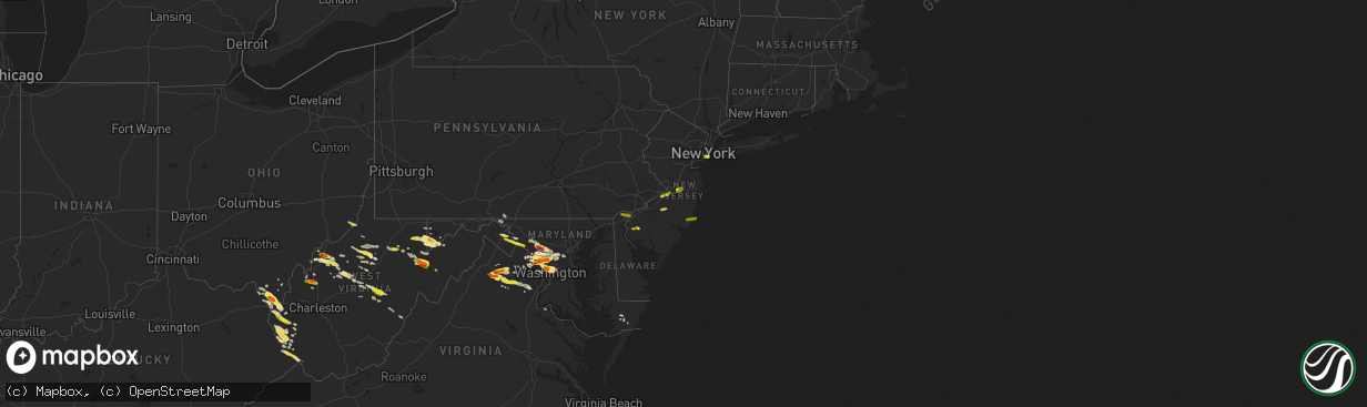
Hail
Wind
12,263
Estimated number of impacted properties by a 1.00" hail or larger0
Estimated number of impacted properties by a 1.75" hail or larger0
Estimated number of impacted properties by a 2.50" hail or largerStorm reports in New Jersey
New Jersey
| Date | Description |
|---|---|
| 06/02/20196:43 PM CDT | A local report indicates 1.00 inch wind near 2 ESE MEDFORD LAKES |
| 06/02/20196:30 PM CDT | Several trees and power lines down. Time estimated from radar. |
| 06/02/20196:17 PM CDT | U.s. Highway 40 closed between state highway 77 and county road 648 owing to downed power cables. Time estimated from radar. |
| 06/02/20192:55 PM CDT | A local report indicates 1.00 inch wind near COLUMBUS |
| 06/02/20194:32 AM CDT | At 931 PM EDT, severe thunderstorms were located along a line extending from near Newark to Tompkinsville to Sandy Hook, moving northeast at 30 mph. HAZARD...60 mph wind gusts and penny size hail. SOURCE...Radar indicated. IMPACT...Expect damage to trees and power lines. Severe thunderstorms will be near... The Verrazano Narrows Bridge around 935 PM EDT. Coney Island and Bay Ridge around 940 PM EDT. Flatbush and Lower East Side around 945 PM EDT. Hoboken and Crown Heights around 950 PM EDT. Rockaway Beach and Ridgefield around 955 PM EDT. Forest Hills and Fort Lee around 1000 PM EDT. Jamaica and Flushing around 1005 PM EDT. East Tremont and Valley Stream around 1010 PM EDT. Garden City and Lynbrook around 1015 PM EDT. |
| 06/02/20194:14 AM CDT | At 913 PM EDT, severe thunderstorms were located along a line extending from Old Bridge to near Allenwood, moving east at 55 mph. HAZARD...60 mph wind gusts and quarter size hail. SOURCE...Radar indicated. IMPACT...Minor damage to vehicles is possible. Wind damage to roofs, siding, trees, and power lines is possible. Locations impacted include... Long Branch, Asbury Park, Sandy Hook, Middletown, Old Bridge, East Brunswick, Marlboro, Tinton Falls, Holmdel, Red Bank, Matawan, Highlands, Brownville, Navesink, Lincroft, Morganville, South River, Eatontown, West Long Branch and Keyport. |
| 06/02/20194:10 AM CDT | At 910 PM EDT, severe thunderstorms were located along a line extending from near Chatham to Sayreville to near Tinton Falls, moving northeast at 75 mph. HAZARD...60 mph wind gusts. SOURCE...Radar indicated. IMPACT...Expect damage to trees and power lines. Severe thunderstorms will be near... Summit and Millburn around 915 PM EDT. Elizabeth and Bloomfield around 920 PM EDT. Newark and Jersey City around 925 PM EDT. Paramus and Ridgewood around 930 PM EDT. |
| 06/02/20194:07 AM CDT | At 906 PM EDT, severe thunderstorms were located along a line extending from Far Hills to near Edison, moving east at 25 mph. HAZARD...60 mph wind gusts and penny size hail. SOURCE...Radar indicated. IMPACT...Damage to roofs, siding, trees, and power lines is possible. Locations impacted include... New Brunswick, Perth Amboy, Morristown, Somerville, Somerset, Edison, East Brunswick, Sayreville, Carteret, Madison, Middlesex, Florham Park, East Hanover, Bound Brook, Chatham, Peapack And Gladstone, Far Hills, Colonia, Martinsville and Millington. |
| 06/02/20193:13 AM CDT | At 813 PM EDT, severe thunderstorms were located along a line extending from near Pemberton to near Penn State Forest, moving east at 35 mph. HAZARD...60 mph wind gusts and quarter size hail. SOURCE...Radar indicated. IMPACT...Minor damage to vehicles is possible. Wind damage to roofs, siding, trees, and power lines is possible. Locations impacted include... Toms River, Lakewood, Jackson, Howell, Barnegat, Tinton Falls, Beachwood, Manasquan, Point Pleasant Beach, Tuckerton, Presidential Lakes Estates, Seaside Heights, Lakehurst, Pemberton, Farmingdale, Surf City, Wrightstown, Mantoloking, Allenwood and Six Flags Theme Park. |
| 06/02/20192:51 AM CDT | At 751 PM EDT, severe thunderstorms were located along a line extending from Woodbury to near Olivet, moving east at 30 mph. HAZARD...60 mph wind gusts and quarter size hail. SOURCE...Radar indicated. IMPACT...Minor damage to vehicles is possible. Wind damage to roofs, siding, trees, and power lines is possible. Locations impacted include... Vineland, Millville, Bridgeton, Gloucester City, Cherry Hill, Evesham, Mount Laurel, Deptford, Voorhees, Medford, Pleasantville, Glassboro, Lindenwold, Hammonton, Lumberton, Bellmawr, Woodbury, Pitman, Northfield and Clayton. |
| 06/02/20192:14 AM CDT | At 714 PM EDT, severe thunderstorms were located along a line extending from Swedesboro to Seabrook Farms, moving east at 30 mph. HAZARD...60 mph wind gusts and quarter size hail. SOURCE...Radar indicated. IMPACT...Minor damage to vehicles is possible. Wind damage to roofs, siding, trees, and power lines is possible. Locations impacted include... Vineland, Millville, Bridgeton, Evesham, Deptford, Voorhees, Medford, West Deptford, Glassboro, Lindenwold, Hammonton, Bellmawr, Woodbury, Pitman, Clayton, Berlin, Shamong, Paulsboro, Buena and Magnolia. |
| 06/02/20192:11 AM CDT | At 711 PM EDT, a severe thunderstorm was located over Pottstown, or 14 miles east of Reading, moving east at 55 mph. HAZARD...60 mph wind gusts and quarter size hail. SOURCE...Radar indicated. IMPACT...Minor damage to vehicles is possible. Wind damage to roofs, siding, trees, and power lines is possible. Locations impacted include... Pottstown, Phoenixville, Lansdale, West Norriton, East Norriton, Perkasie, Doylestown, Byram, Hatboro, Souderton, Bedminster, Ambler, Collegeville, Royersford, Chalfont, Tinicum, Trappe, Hatfield, New Hope and Newtown. |
| 06/01/201911:37 PM CDT | At 437 PM EDT, a severe thunderstorm was located near Beach Haven West, or 18 miles south of Toms River, moving east at 30 mph. HAZARD...60 mph wind gusts and quarter size hail. SOURCE...Radar indicated. IMPACT...Minor damage to vehicles is possible. Wind damage to roofs, siding, trees, and power lines is possible. Locations impacted include... Barnegat, Tuckerton, Surf City, Port Republic, Warren Grove, Bass River State Forest, New Gretna, Beach Haven West, Mystic Island, Manahawkin, Ocean Acres and Waretown. |
| 06/01/201911:34 PM CDT | At 434 PM EDT, a severe thunderstorm was located over Six Flags Theme Park, or 17 miles east of Trenton, moving northeast at 30 mph. HAZARD...60 mph wind gusts and quarter size hail. SOURCE...Radar indicated. IMPACT...Minor damage to vehicles is possible. Wind damage to roofs, siding, trees, and power lines is possible. Locations impacted include... Asbury Park, Lakewood, Middletown, Jackson, Howell, Marlboro, Manalapan, Tinton Falls, Holmdel, Red Bank, Keansburg, Matawan, Farmingdale, Roosevelt, Allenwood, East Freehold, Six Flags Theme Park, West Freehold, Cassville and Adelphia. |
| 06/01/201910:18 PM CDT | At 318 PM EDT, a severe thunderstorm was located over Marshallton, or near West Chester, moving east at 25 mph. HAZARD...60 mph wind gusts and half dollar size hail. SOURCE...Radar indicated. IMPACT...Minor damage to vehicles is possible. Wind damage to roofs, siding, trees, and power lines is possible. Locations impacted include... Philadelphia, West Chester, Norristown, Chester, Phoenixville, West Norriton, East Norriton, Yeadon, Westtown, Downingtown, Conshohocken, Folcroft, Ambler, Swarthmore, Paulsboro, Kennett Square, Narberth, East Lansdowne, Arden and Talleyville. |
| 06/01/20199:40 PM CDT | At 239 PM EDT, a severe thunderstorm was located over Kennett Square, or 10 miles southwest of West Chester, moving northeast at 25 mph. HAZARD...60 mph wind gusts and quarter size hail. SOURCE...Radar indicated. IMPACT...Minor damage to vehicles is possible. Wind damage to roofs, siding, trees, and power lines is possible. Locations impacted include... Wilmington, West Chester, Chester, Westtown, Kennett Square, Arden, Cheyney, North Star, Talleyville, Elam, Marshallton, Lima, Pike Creek, Chelsea, Ashland, Gradyville, Greenville, Paoli, Chester Township and Ladenberg. |
| 06/01/20198:36 PM CDT | A local report indicates 58 MPH wind near 2 S SANDY HOOK |
| 06/01/20198:34 PM CDT | Tree fell on house on lenox avenue between st. Paul street and s euclid avenue |
| 06/01/20198:20 PM CDT | Downed tree on nj 36 northbound in the area of main street. All lanes closed. Time estimated from radar. |
| 06/01/20197:53 PM CDT | Tree into a house and wires down on maple avenue in franklin twp. Time estimated from radar. |
| 06/01/20197:47 PM CDT | Downed tree on u.s. Highway 206 south of brooks blvd. All lanes closed. Time estimated from radar. |
| 06/01/20197:40 PM CDT | Some trees down which took down wires on a portion of sunnymeade road in hillsborough. Time estimated from radar. |
| 06/01/20197:34 PM CDT | A local report indicates 61 MPH wind near WARETOWN |
| 06/01/20197:15 PM CDT | Delayed report. Large trees down at a few residences. Time estimated from radar. |
All States Impacted by Hail Map on June 2, 2019
Cities Impacted by Hail Map on June 2, 2019
- Ripley, WV
- Cream Ridge, NJ
- Hope, NM
- Artesia, NM
- Fayetteville, AR
- Springdale, AR
- Gainesville, VA
- Glen Echo, MD
- McLean, VA
- Chevy Chase, MD
- Washington, DC
- Bethesda, MD
- Santa Fe, NM
- Salem, WV
- Clarksburg, WV
- West Union, WV
- New Milton, WV
- Roswell, NM
- Ceredo, WV
- Ashland, KY
- Huntington, WV
- Catlettsburg, KY
- Kenova, WV
- South Point, OH
- Hagerman, NM
- Lovington, NM
- Tinnie, NM
- Dexter, NM
- Harts, WV
- West Chester, PA
- Delaplane, VA
- Markham, VA
- Tijeras, NM
- Given, WV
- Lake Arthur, NM
- Clear Spring, MD
- Big Pool, MD
- Marlinton, WV
- The Plains, VA
- Jacksonburg, WV
- Alma, WV
- Chapmanville, WV
- Hermosa, SD
- Rapid City, SD
- Black Hawk, SD
- Fairburn, SD
- Buffalo Gap, SD
- Keystone, SD
- Orma, WV
- Arnoldsburg, WV
- Mount Zion, WV
- Grantsville, WV
- Normantown, WV
- Millstone, WV
- Goodwell, OK
- Harrisville, WV
- Smithville, WV
- Medora, ND
- Oakland, MD
- Lowell, AR
- Rogers, AR
- Wilmington, DE
- Mineral Wells, WV
- Elizabeth, WV
- Sandia Park, NM
- Peralta, NM
- Edgewood, NM
- Raton, NM
- Saint Paul, NE
- Bladensburg, MD
- Arlington, VA
- Brentwood, MD
- Potomac, MD
- Rockville, MD
- Kensington, MD
- Garrett Park, MD
- Silver Spring, MD
- Hyattsville, MD
- Derwood, MD
- Great Falls, VA
- Spencerville, MD
- Mount Rainier, MD
- Cabin John, MD
- Gaithersburg, MD
- Clarksburg, MD
- Germantown, MD
- Ijamsville, MD
- Damascus, MD
- Kimball, NE
- Bosque Farms, NM
- Los Lunas, NM
- Belen, NM
- Maxwell, NM
- Cimarron, NM
- Bowman, ND
- Rhame, ND
- Amidon, ND
- Vincentown, NJ
- Yoder, WY
- Guernsey, WY
- Wheatland, WY
- Robeline, LA
- Coushatta, LA
- Marthaville, LA
- Pedro, OH
- Ironton, OH
- Franklin Furnace, OH
- Walker, WV
- Scottown, OH
- Willow Wood, OH
- Pine Bluffs, WY
- Shawnee, WY
- Greenup, KY
- Columbus, NJ
- Friendsville, MD
- Terra Alta, WV
- McHenry, MD
- Sharpsburg, MD
- Rohrersville, MD
- Keedysville, MD
- Knoxville, MD
- Marshall, VA
- Linden, VA
- Front Royal, VA
- Upperville, VA
- Campo, CO
- Boise City, OK
- Kenton, OK
- Upper Tract, WV
- Cabins, WV
- Marathon, TX
- Philippi, WV
- Moatsville, WV
- Rowlesburg, WV
- Eglon, WV
- Gormania, WV
- Tunnelton, WV
- Aurora, WV
- Grenville, NM
- Spencer, WV
- Seminole, TX
- Elmer, NJ
- Dryfork, WV
- Davis, WV
- Parsons, WV
- Red Creek, WV
- Hambleton, WV
- Hendricks, WV
- Crawford, NE
- Cheyenne, WY
- Sterling, VA
- Milnesand, NM
- Burlington, NJ
- Shenandoah Junction, WV
- Brunswick, MD
- Kearneysville, WV
- Lovettsville, VA
- Point Of Rocks, MD
- Harpers Ferry, WV
- Jefferson, MD
- King George, VA
- Saint Francis, KS
- Mount Airy, MD
- Brookeville, MD
- Monrovia, MD
- Ulysses, KS
- Satanta, KS
- Ashburn, VA
- Herndon, VA
- Williamson, WV
- Belfry, KY
- Martinsburg, WV
- Shepherdstown, WV
- Leland, NC
- Valentine, TX
- Martin, SD
- Manassas, VA
- Nokesville, VA
- Bristow, VA
- Sentinel Butte, ND
- Douglas, WY
- Hertford, NC
- Malvern, PA
- Phoenixville, PA
- Eads, CO
- Kenna, WV
- Liberty, WV
- Bordentown, NJ
- Mount Holly, NJ
- Kermit, WV
- Crum, WV
- Lenore, WV
- Dunlow, WV
- Warfield, KY
- Dingess, WV
- Breeden, WV
- Lovely, KY
- Wilsondale, WV
- Genoa, WV
- Fort Gay, WV
- Shock, WV
- Catlett, VA
- Warrenton, VA
- Tuthill, SD
- Dover, DE
- Cheswold, DE
- Troy, WV
- Columbia, MD
- Fulton, MD
- Ashton, MD
- Laurel, MD
- Lincoln University, PA
- Oxford, PA
- West Grove, PA
- Webster Springs, WV
- Diana, WV
- Hacker Valley, WV
- Cowen, WV
- Sutton, WV
- Pocomoke City, MD
- Palestine, WV
- Columbia, NC
- Lancaster, PA
- Willow Street, PA
- Nemo, SD
- Piedmont, SD
- Munday, WV
- Springer, NM
- Flemington, WV
- Chester Gap, VA
- Hume, VA
- Flint Hill, VA
- Huntly, VA
- Cerrillos, NM
- Bushnell, NE
- Poolesville, MD
- Boyds, MD
- Cody, NE
- Weston, WV
- Jane Lew, WV
- Kitts Hill, OH
- Chesapeake, OH
- Burnsville, WV
- Linn, WV
- Carpenter, WY
- Burns, WY
- Elk Garden, WV
- Mount Storm, WV
- Crookston, NE
- Harrisburg, NE
- Dickerson, MD
- Jarales, NM
- Laguna, NM
- Delbarton, WV
- Golva, ND
- Dell City, TX
- East Lynn, WV
- Ranger, WV
- Branchland, WV
- Mercersburg, PA
- Haswell, CO
- Kilgore, NE
- Saint Francis, SD
- Accident, MD
- Swanton, MD
- Birch River, WV
- Rosedale, WV
- Gassaway, WV
- Cheyney, PA
- Glen Mills, PA
- Thornton, PA
- Little Birch, WV
- Forest Hills, KY
- Hardy, KY
- McCarr, KY
- Alpine, TX
- Glenville, WV
- Camden, WV
- Estancia, NM
- Brooklyn, NY
- Aldie, VA
- Belleville, WV
- Ravenswood, WV
- Rockport, WV
- Majestic, KY
- Hurley, VA
- Matewan, WV
- Stopover, KY
- Elkins, AR
- Lavalette, WV
- Barboursville, WV
- Wayne, WV
- Paden City, WV
- New Martinsville, WV
- Sardis, OH
- Fort Davis, TX
- Marfa, TX
- Nenzel, NE
- Chadron, NE
- Newburg, WV
- Kingwood, WV
- Wesley, AR
- Wanblee, SD
- Harrison, NE
- Whitney, NE
- Princess Anne, MD
- Elizabeth City, NC
- Wheelersburg, OH
- Salt Flat, TX
- Kadoka, SD
- White River, SD
- Long Valley, SD
- Annapolis Junction, MD
- Jessup, MD
- Hanover, MD
- Fort George G Meade, MD
- Severn, MD
- Colorado Springs, CO
- Medford, NJ
- Wasco, CA
- Capitan, NM
- Quantico, VA
- Auburn, WV
- Deadwood, SD
- Leesburg, VA
- Pennsboro, WV
- Allen, SD
- Montgomery Village, MD
- Sidney, NE
- Gardners, PA
- Arlington, CO
- Woodsfield, OH
- Montrose, WV
- Prichard, WV
- Cloudcroft, NM
- Bridgeton, NJ
- Wilmington, NC
- Frederick, MD
- Manville, WY
- Coxs Mills, WV
- Alum Bridge, WV
- Petroleum, WV
- Evans, WV
- Leon, WV
- Woodbridge, VA
- Worthington, KY
- Tatum, NM
- Sandy Spring, MD
- Olney, MD
- Hay Springs, NE
- Creston, WV
- Moriarty, NM
- Thomas, WV
- French Creek, WV
- Freeburn, KY
- South Williamson, KY
- Jeffersonton, VA
- Encino, NM
- Bridgeport, WV
- Kitzmiller, MD
- Amissville, VA
- Patriot, OH
- Coatesville, PA
- Kennett Square, PA
- Cottageville, WV
- Vienna, VA
- Grafton, WV
- Berkeley Springs, WV
- Fort Hancock, TX
- Broken Bow, NE
- Felt, OK
- Rushville, NE
- Merchantville, NJ
- Pennsauken, NJ
- Cubero, NM
- Mount Joy, PA
- Landisville, PA
- Manheim, PA
- Parkersburg, WV
- Washington, WV
- Reedy, WV
- Narvon, PA
- Stevens, PA
- Ephrata, PA
- Denver, PA
- New Holland, PA
- Calhan, CO
- Middleburg, VA
- Fort Laramie, WY
- Takoma Park, MD
- Riverdale, MD
- Beltsville, MD
- Burtonsville, MD
- Capitol Heights, MD
- Brinklow, MD
- Washington Grove, MD
- Highland, MD
- Clarksville, MD
- Dayton, MD
- Calabash, NC
- Ash, NC
- Holden, WV
- Center Point, WV
- Yoder, CO
- Falls Church, VA
- Kerens, WV
- Dunn Loring, VA
- Coalinga, CA
- Sugar City, CO
- Big Bend National Park, TX
- Crown City, OH
- Boyce, VA
- Big Springs, WV
- Graysville, OH
- Keyser, WV
- New Creek, WV
- Dix, NE
- Willard, NM
- Tierra Amarilla, NM
- Chama, NM
- Mayhill, NM
- Sistersville, WV
- Purcellville, VA
- Charles Town, WV
- Harman, WV
- Bowden, WV
- Kiahsville, WV
- Bentonville, VA
- Caputa, SD
- Pine Ridge, SD
- Belvidere, SD
- Norris, SD
- Ocean Isle Beach, NC
- Sunset Beach, NC
- Longwood, NC
- Merriman, NE
- Chesterfield, NJ
- Freehold, NJ
- Jackson, NJ
- New Egypt, NJ
- Millstone Township, NJ
- Allentown, NJ
- West Creek, NJ
- Manahawkin, NJ
- Beach Haven, NJ
- Millersville, PA
- Strasburg, PA
- Pedricktown, NJ
- Penns Grove, NJ
- Woodstown, NJ
- Alloway, NJ
- Salem, NJ
- Sierra Blanca, TX
- Wall, TX
- San Angelo, TX
- Morton, TX
- Whiteface, TX
- Tokio, TX
- Meadow, TX
- Levelland, TX
- Plains, TX
- Ropesville, TX
- Weston, CO
- Las Animas, CO
- Glendo, WY


