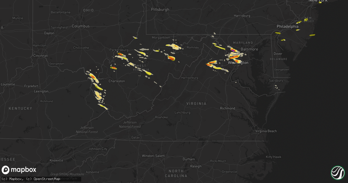
Hail Map in Virginia on June 2, 2019
Get this storm
June 2 map
$229
one time, instant access
Download today. No call, no setup
Keep the $229
Bought the map and want the full workflow? Apply the entire $229 to a subscription within 7 days. None of it is wasted.
Every map, not just this one
This buys you this map. Subscription and you get every map we run, in the markets you choose from a few cities to whole states to nationwide. Plus real-time alerts the moment a storm fires.
Contact data
Name, contact info, occupancy, even credit band for addresses in the footprint. You go from where it hit to who to call.
Become the source they trust
Unlimited branding weather history reports on demand. You already have the documented answer ready for the property owner, and you are the one who showed up with it.
Property data and RoofTrace estimates
Pull up any address you have got, its value and the exact code rules for that jurisdiction, straight from One Click Code. Then RoofTrace estimates the squares, pitch, and roof value, priced the way you price.
Storm reports in Virginia
Virginia
| Date | Description |
|---|---|
| 06/02/20196:53 PM CDT | Multiple trees down in eastern bedford county. Particularly on jordantown rd and hardy rd. |
| 06/02/20196:50 PM CDT | Numerous trees and power lines down in the 700 block of shelbourne ave... As well as nearby areas of clairborne ave and hardy road... All in the vinton area of far east |
| 06/02/20196:48 PM CDT | Trees down on beagle club rd. |
| 06/02/20196:42 PM CDT | Power pole snapped. Several trees down. |
| 06/02/20196:39 PM CDT | Tree down on house on shelbourne ave. Time estimated by radar. |
| 06/02/20196:39 PM CDT | Tree down on cars on underhill ave. No injuries reported. Time estimated by radar. |
| 06/02/20196:39 PM CDT | Corrects previous tstm wnd dmg report from 2 ne stewartsville. Tree down on cars on underhill ave. No injuries reported. Time estimated by radar. |
| 06/02/20196:32 PM CDT | An area of paneling torn off of the roanoke times building in downtown roanoke. It was indicated there was already some missing before the storm occurred. Time estimate |
| 06/02/20196:32 PM CDT | Tree down on 13th street. Time estimated by radar. |
| 06/02/20196:22 PM CDT | 8-inch diameter tree branch down shenandoah rd in salem. |
| 06/02/20195:59 PM CDT | Multiple trees down at the intersection of izaak walton dr. And bristow rd. |
| 06/02/20195:45 PM CDT | Spotter reports several trees and large limbs down on his property. |
| 06/02/20195:37 PM CDT | Tree down across bellona road at bel air road |
| 06/02/20195:30 PM CDT | House damage from limbs from two trees. One nearby tree down and another with the top snapped off. |
| 06/02/20195:14 PM CDT | Tree blocking horner rd and summerland dr |
| 06/02/20194:45 PM CDT | Multiple trees down at the intersection of izaak walton dr. And bristow rd. |
| 06/02/20194:40 PM CDT | Large tree down across crockett road at hooe road. |
| 06/02/20194:31 PM CDT | Hail up to golf ball sized. |
| 06/02/20194:31 PM CDT | A local report indicates 1.75 inch wind near 1 NW GREAT FALLS |
| 06/02/20194:29 PM CDT | Dime to quarter size hail at dulles shopping center |
| 06/02/20194:27 PM CDT | A local report indicates 1.00 inch wind near 2 NW GREAT FALLS |
| 06/02/20194:26 PM CDT | Quarter size hail near george washington parkway and turkey run rd |
| 06/02/20194:02 PM CDT | Quarter size hail at giant food pharmacy |
| 06/02/20194:02 PM CDT | Tree down blocking road in 1200 block of maiden springs rd. Time estimated by radar. |
| 06/02/20194:02 PM CDT | One tree down on maiden springs rd. Time estimated by radar. |
| 06/02/20193:57 PM CDT | A local report indicates 1.00 inch wind near HUME |
| 06/02/20193:42 PM CDT | A local report indicates 1.00 inch wind near COUNTRYSIDE |
| 06/02/20193:30 PM CDT | Social media pictures of several small trees down along with small hail. |
| 06/02/20193:20 PM CDT | Golf ball size hail at aspen dale winery at the barn |
| 06/02/20193:15 PM CDT | Ping pong ball size hail at linden vineyards |
| 06/02/20192:06 PM CDT | Quarter sized hail reported in harper's ferry |
| 06/02/20196:44 AM CDT | At 1144 PM EDT, severe thunderstorms were located along a line extending from near Parsonsburg to 7 miles northwest of Snow Hill to near University Of Maryland Eastern Shore, moving southeast at 25 mph. HAZARD...Ping pong ball size hail and 60 mph wind gusts. SOURCE...Radar indicated. IMPACT...People and animals outdoors will be injured. Expect hail damage to roofs, siding, windows, and vehicles. Expect wind damage to trees and powerlines. Severe thunderstorms will be near, Pocomoke City and Snow Hill around 1200 AM EDT. Berlin and Newark around 1210 AM EDT.Other locations impacted by these severe thunderstorms includeHorntown, Boxiron, Ocean City Municipality, Salisbury-Wicomico,Cokesbury, Goodwill, Public Landing, Greenbackville, Ironshire andWillards. |
| 06/02/20194:17 AM CDT | At 916 PM EDT, severe thunderstorms were located along a line extending from near Gumboro to near Newark to near West Pocomoke, moving east at 35 mph. HAZARD...60 mph wind gusts and quarter size hail. SOURCE...Radar indicated. IMPACT...Minor damage to vehicles is possible. Expect wind damage to trees and powerlines. Severe thunderstorms will be near, Snow Hill and Newark around 920 PM EDT. Berlin and Ocean Pines around 930 PM EDT. Ocean City and Cape Isle Of Wight around 940 PM EDT.Other locations impacted by these severe thunderstorms includeHorntown, Bishop, Ocean City Municipality, Cokesbury, Goodwill,Greenbackville, Kingston, Cedartown, Pittsville and Powellville. |
| 06/02/20193:38 AM CDT | At 838 PM EDT, a severe thunderstorm was located over Dahlgren, moving east at 45 mph. HAZARD...60 mph wind gusts and quarter size hail. SOURCE...Radar indicated. IMPACT...Damaging winds will cause some trees and large branches to fall. This could injure those outdoors, as well as damage homes and vehicles. Roadways may become blocked by downed trees. Localized power outages are possible. Unsecured light objects may become projectiles. Locations impacted include... Leonardtown, Dahlgren, Port Tobacco River, Wicomico River, Popes Creek, Golden Beach, Wicomico, Hughesville, Mechanicsville, Charlotte Hall, Cobb Island, Aquasco, Rock Point, Bushwood, Clements, Issue, Tompkinsville, Abell, Chaptico and Ninde. |
| 06/02/20192:53 AM CDT | At 753 PM EDT, severe thunderstorms were located along a line extending from near Montvale to Goodview to near Burnt Chimney, moving east at 35 mph. HAZARD...60 mph wind gusts and quarter size hail. SOURCE...Radar indicated. IMPACT...Hail damage to vehicles is expected. Expect wind damage to roofs, siding, and trees. Locations impacted include... Bedford... Stewartsville... Huddleston... Montvale... and Moneta.This includes The following Location The National D-Day Memorial. |
| 06/02/20191:28 AM CDT | At 628 PM EDT, a severe thunderstorm was located near Mountain Grove, or 9 miles southeast of Marlinton, moving southeast at 25 mph. HAZARD...60 mph wind gusts and quarter size hail. SOURCE...Radar indicated. IMPACT...Hail damage to vehicles is expected. Expect wind damage to roofs, siding, and trees. Locations impacted include... Minnehaha Springs. |
| 06/02/201912:54 AM CDT | At 554 PM EDT, a severe thunderstorm was located near Warrenton, moving east at 20 mph. HAZARD...60 mph wind gusts. SOURCE...Radar indicated. IMPACT...Damaging winds will cause some trees and large branches to fall. This could injure those outdoors, as well as damage homes and vehicles. Roadways may become blocked by downed trees. Localized power outages are possible. Unsecured light objects may become projectiles. Locations impacted include... Warrenton, Bealeton, Opal, Catlett, Calverton, Midland, Turnbull, Casanova and Jeffersonton. |
| 06/02/201912:37 AM CDT | At 536 PM EDT, a severe thunderstorm was located near Linton Hall, or 9 miles southwest of Centreville, moving east at 30 mph. HAZARD...Half dollar size hail. SOURCE...Radar indicated. IMPACT...Some hail damage to agriculture is expected. Locations impacted include... Dale City, Springfield, Fort Belvoir, Woodbridge, Lake Ridge, Burke, Linton Hall, Lincolnia, Montclair, Lorton, Franconia, Bull Run, Newington, I395 and I495 Interchange, Manassas, West Springfield, Manassas Park, Fairfax Station, New Baltimore and Independent Hill. |
| 06/02/201912:25 AM CDT | At 525 PM EDT, a severe thunderstorm was located over Sterling, or over Lowes Island, moving east at 20 mph. HAZARD...60 mph wind gusts and quarter size hail. SOURCE...Radar indicated. IMPACT...Damaging winds will cause some trees and large branches to fall. This could injure those outdoors, as well as damage homes and vehicles. Roadways may become blocked by downed trees. Localized power outages are possible. Unsecured light objects may become projectiles. Locations impacted include... Germantown, Rockville, Gaithersburg, Reston, Herndon, Lowes Island, American Legion Bridge, Potomac, Ashburn, Montgomery Village, Sterling, North Potomac, Wolf Trap, Great Falls, Countryside, Darnestown, Cabin John, Belleview, Bradley Farms and Congressional Manor. |
| 06/01/201911:45 PM CDT | At 445 PM EDT, a severe thunderstorm was located near Warrenton, moving east at 20 mph. HAZARD...60 mph wind gusts and quarter size hail. SOURCE...Radar indicated. IMPACT...Damaging winds will cause some trees and large branches to fall. This could injure those outdoors, as well as damage homes and vehicles. Roadways may become blocked by downed trees. Localized power outages are possible. Unsecured light objects may become projectiles. Locations impacted include... Warrenton, Linton Hall, Gainesville, New Baltimore, Catlett, Calverton, Turnbull, Airlie, Broken Hill, Auburn, Casanova and Greenwich. |
| 06/01/201911:42 PM CDT | Tree downed along va-178 near pungoteague road. |
| 06/01/201911:36 PM CDT | At 436 PM EDT, a severe thunderstorm was located near Front Royal, moving east at 25 mph. HAZARD...60 mph wind gusts and quarter size hail. SOURCE...Radar indicated. IMPACT...Damaging winds will cause some trees and large branches to fall. This could injure those outdoors, as well as damage homes and vehicles. Roadways may become blocked by downed trees. Localized power outages are possible. Unsecured light objects may become projectiles. Locations impacted include... Front Royal, Hume, Marshall, Chester Gap, Flint Hill, Glen Echo, Huntly, Arco, Ashville, Cresthill, Orlean and Ada. |
| 06/01/201911:30 PM CDT | Tree and power line down with power outages. |
| 06/01/201911:25 PM CDT | Tree downed along bradley bridge road near woodpecker road va-626. Time is radar estimated. |
| 06/01/201911:21 PM CDT | At 421 PM EDT, a severe thunderstorm was located over Delaplane, or 11 miles east of Front Royal, moving east at 25 mph. HAZARD...60 mph wind gusts and quarter size hail. SOURCE...Radar indicated. IMPACT...Damaging winds will cause some trees and large branches to fall. This could injure those outdoors, as well as damage homes and vehicles. Roadways may become blocked by downed trees. Localized power outages are possible. Unsecured light objects may become projectiles. Locations impacted include... Middleburg, Delaplane, Marshall, Saint Louis, Aldie, Halfway, Ashville and Rectortown. |
| 06/01/201910:51 PM CDT | At 350 PM EDT, a severe thunderstorm was located 8 miles south of Front Royal, moving east at 25 mph. HAZARD...60 mph wind gusts and quarter size hail. SOURCE...Radar indicated. IMPACT...Damaging winds will cause some trees and large branches to fall. This could injure those outdoors, as well as damage homes and vehicles. Roadways may become blocked by downed trees. Localized power outages are possible. Unsecured light objects may become projectiles. Locations impacted include... Hume, Linden, Chester Gap, Flint Hill, Huntly, Arco, Cresthill, Orlean, Karo, Glen Echo, Bentonville, Markham and Browntown. |
| 06/01/201910:45 PM CDT | At 345 PM EDT, a severe thunderstorm was located over Buskirk, or 9 miles southeast of Williamson, moving east at 25 mph. HAZARD...60 mph wind gusts and quarter size hail. SOURCE...Radar indicated. IMPACT...Hail damage to vehicles is expected. Expect wind damage to roofs, siding, and trees. Locations impacted include... Jamboree, Argo, Majestic, Board Tree, Phelps, Woodman and Edgarton. |
| 06/01/201910:32 PM CDT | At 332 PM EDT, a severe thunderstorm was located near Bridgewater, or 9 miles west of Harrisonburg, moving east at 20 mph. HAZARD...60 mph wind gusts and quarter size hail. SOURCE...Radar indicated. IMPACT...Damaging winds will cause some trees and large branches to fall. This could injure those outdoors, as well as damage homes and vehicles. Roadways may become blocked by downed trees. Localized power outages are possible. Unsecured light objects may become projectiles. Locations impacted include... Harrisonburg, Bridgewater, Dale Enterprise, Dayton, Mount Crawford, Penn Laird, Montezuma, Clover Hill, Pleasant Valley, Keezletown and Hinton. |
| 06/01/201910:01 PM CDT | At 301 PM EDT, a severe thunderstorm was located near Harpers Ferry, or near Charles Town, moving east at 10 mph. HAZARD...Quarter size hail. SOURCE...Radar indicated. IMPACT...Some hail damage to agriculture is expected. Locations impacted include... Ranson, Harpers Ferry, Bolivar, Shenandoah Junction, Brownsville, Pleasantville, Neersville, Millville, Halltown and Bakerton. |
| 06/01/20198:49 PM CDT | At 149 PM EDT, a severe thunderstorm was located near Martinsburg, moving east at 10 mph. HAZARD...60 mph wind gusts and quarter size hail. SOURCE...Radar indicated. IMPACT...Damaging winds will cause some trees and large branches to fall. This could injure those outdoors, as well as damage homes and vehicles. Roadways may become blocked by downed trees. Localized power outages are possible. Unsecured light objects may become projectiles. Locations impacted include... Shepherdstown, Ranson, Harpers Ferry, Kearneysville, Keedysville, Bolivar, Sharpsburg, Shenandoah Junction, Rohrersville, Gapland, Brownsville, Antietam, Winebrenners Cross, Moler Crossroads, Pleasantville, Bakerton and Halltown. |
All States Impacted by Hail Map on June 2, 2019
Cities Impacted by Hail Map on June 2, 2019
- Ripley, WV
- Cream Ridge, NJ
- Hope, NM
- Artesia, NM
- Fayetteville, AR
- Springdale, AR
- Gainesville, VA
- Glen Echo, MD
- McLean, VA
- Chevy Chase, MD
- Washington, DC
- Bethesda, MD
- Santa Fe, NM
- Salem, WV
- Clarksburg, WV
- West Union, WV
- New Milton, WV
- Roswell, NM
- Ceredo, WV
- Ashland, KY
- Huntington, WV
- Catlettsburg, KY
- Kenova, WV
- South Point, OH
- Hagerman, NM
- Lovington, NM
- Tinnie, NM
- Dexter, NM
- Harts, WV
- West Chester, PA
- Delaplane, VA
- Markham, VA
- Tijeras, NM
- Given, WV
- Lake Arthur, NM
- Clear Spring, MD
- Big Pool, MD
- Marlinton, WV
- The Plains, VA
- Jacksonburg, WV
- Alma, WV
- Chapmanville, WV
- Hermosa, SD
- Rapid City, SD
- Black Hawk, SD
- Fairburn, SD
- Buffalo Gap, SD
- Keystone, SD
- Orma, WV
- Arnoldsburg, WV
- Mount Zion, WV
- Grantsville, WV
- Normantown, WV
- Millstone, WV
- Goodwell, OK
- Harrisville, WV
- Smithville, WV
- Medora, ND
- Oakland, MD
- Lowell, AR
- Rogers, AR
- Wilmington, DE
- Mineral Wells, WV
- Elizabeth, WV
- Sandia Park, NM
- Peralta, NM
- Edgewood, NM
- Raton, NM
- Saint Paul, NE
- Bladensburg, MD
- Arlington, VA
- Brentwood, MD
- Potomac, MD
- Rockville, MD
- Kensington, MD
- Garrett Park, MD
- Silver Spring, MD
- Hyattsville, MD
- Derwood, MD
- Great Falls, VA
- Spencerville, MD
- Mount Rainier, MD
- Cabin John, MD
- Gaithersburg, MD
- Clarksburg, MD
- Germantown, MD
- Ijamsville, MD
- Damascus, MD
- Kimball, NE
- Bosque Farms, NM
- Los Lunas, NM
- Belen, NM
- Maxwell, NM
- Cimarron, NM
- Bowman, ND
- Rhame, ND
- Amidon, ND
- Vincentown, NJ
- Yoder, WY
- Guernsey, WY
- Wheatland, WY
- Robeline, LA
- Coushatta, LA
- Marthaville, LA
- Pedro, OH
- Ironton, OH
- Franklin Furnace, OH
- Walker, WV
- Scottown, OH
- Willow Wood, OH
- Pine Bluffs, WY
- Shawnee, WY
- Greenup, KY
- Columbus, NJ
- Friendsville, MD
- Terra Alta, WV
- McHenry, MD
- Sharpsburg, MD
- Rohrersville, MD
- Keedysville, MD
- Knoxville, MD
- Marshall, VA
- Linden, VA
- Front Royal, VA
- Upperville, VA
- Campo, CO
- Boise City, OK
- Kenton, OK
- Upper Tract, WV
- Cabins, WV
- Marathon, TX
- Philippi, WV
- Moatsville, WV
- Rowlesburg, WV
- Eglon, WV
- Gormania, WV
- Tunnelton, WV
- Aurora, WV
- Grenville, NM
- Spencer, WV
- Seminole, TX
- Elmer, NJ
- Dryfork, WV
- Davis, WV
- Parsons, WV
- Red Creek, WV
- Hambleton, WV
- Hendricks, WV
- Crawford, NE
- Cheyenne, WY
- Sterling, VA
- Milnesand, NM
- Burlington, NJ
- Shenandoah Junction, WV
- Brunswick, MD
- Kearneysville, WV
- Lovettsville, VA
- Point Of Rocks, MD
- Harpers Ferry, WV
- Jefferson, MD
- King George, VA
- Saint Francis, KS
- Mount Airy, MD
- Brookeville, MD
- Monrovia, MD
- Ulysses, KS
- Satanta, KS
- Ashburn, VA
- Herndon, VA
- Williamson, WV
- Belfry, KY
- Martinsburg, WV
- Shepherdstown, WV
- Leland, NC
- Valentine, TX
- Martin, SD
- Manassas, VA
- Nokesville, VA
- Bristow, VA
- Sentinel Butte, ND
- Douglas, WY
- Hertford, NC
- Malvern, PA
- Phoenixville, PA
- Eads, CO
- Kenna, WV
- Liberty, WV
- Bordentown, NJ
- Mount Holly, NJ
- Kermit, WV
- Crum, WV
- Lenore, WV
- Dunlow, WV
- Warfield, KY
- Dingess, WV
- Breeden, WV
- Lovely, KY
- Wilsondale, WV
- Genoa, WV
- Fort Gay, WV
- Shock, WV
- Catlett, VA
- Warrenton, VA
- Tuthill, SD
- Dover, DE
- Cheswold, DE
- Troy, WV
- Columbia, MD
- Fulton, MD
- Ashton, MD
- Laurel, MD
- Lincoln University, PA
- Oxford, PA
- West Grove, PA
- Webster Springs, WV
- Diana, WV
- Hacker Valley, WV
- Cowen, WV
- Sutton, WV
- Pocomoke City, MD
- Palestine, WV
- Columbia, NC
- Lancaster, PA
- Willow Street, PA
- Nemo, SD
- Piedmont, SD
- Munday, WV
- Springer, NM
- Flemington, WV
- Chester Gap, VA
- Hume, VA
- Flint Hill, VA
- Huntly, VA
- Cerrillos, NM
- Bushnell, NE
- Poolesville, MD
- Boyds, MD
- Cody, NE
- Weston, WV
- Jane Lew, WV
- Kitts Hill, OH
- Chesapeake, OH
- Burnsville, WV
- Linn, WV
- Carpenter, WY
- Burns, WY
- Elk Garden, WV
- Mount Storm, WV
- Crookston, NE
- Harrisburg, NE
- Dickerson, MD
- Jarales, NM
- Laguna, NM
- Delbarton, WV
- Golva, ND
- Dell City, TX
- East Lynn, WV
- Ranger, WV
- Branchland, WV
- Mercersburg, PA
- Haswell, CO
- Kilgore, NE
- Saint Francis, SD
- Accident, MD
- Swanton, MD
- Birch River, WV
- Rosedale, WV
- Gassaway, WV
- Cheyney, PA
- Glen Mills, PA
- Thornton, PA
- Little Birch, WV
- Forest Hills, KY
- Hardy, KY
- McCarr, KY
- Alpine, TX
- Glenville, WV
- Camden, WV
- Estancia, NM
- Brooklyn, NY
- Aldie, VA
- Belleville, WV
- Ravenswood, WV
- Rockport, WV
- Majestic, KY
- Hurley, VA
- Matewan, WV
- Stopover, KY
- Elkins, AR
- Lavalette, WV
- Barboursville, WV
- Wayne, WV
- Paden City, WV
- New Martinsville, WV
- Sardis, OH
- Fort Davis, TX
- Marfa, TX
- Nenzel, NE
- Chadron, NE
- Newburg, WV
- Kingwood, WV
- Wesley, AR
- Wanblee, SD
- Harrison, NE
- Whitney, NE
- Princess Anne, MD
- Elizabeth City, NC
- Wheelersburg, OH
- Salt Flat, TX
- Kadoka, SD
- White River, SD
- Long Valley, SD
- Annapolis Junction, MD
- Jessup, MD
- Hanover, MD
- Fort George G Meade, MD
- Severn, MD
- Colorado Springs, CO
- Medford, NJ
- Wasco, CA
- Capitan, NM
- Quantico, VA
- Auburn, WV
- Deadwood, SD
- Leesburg, VA
- Pennsboro, WV
- Allen, SD
- Montgomery Village, MD
- Sidney, NE
- Gardners, PA
- Arlington, CO
- Woodsfield, OH
- Montrose, WV
- Prichard, WV
- Cloudcroft, NM
- Bridgeton, NJ
- Wilmington, NC
- Frederick, MD
- Manville, WY
- Coxs Mills, WV
- Alum Bridge, WV
- Petroleum, WV
- Evans, WV
- Leon, WV
- Woodbridge, VA
- Worthington, KY
- Tatum, NM
- Sandy Spring, MD
- Olney, MD
- Hay Springs, NE
- Creston, WV
- Moriarty, NM
- Thomas, WV
- French Creek, WV
- Freeburn, KY
- South Williamson, KY
- Jeffersonton, VA
- Encino, NM
- Bridgeport, WV
- Kitzmiller, MD
- Amissville, VA
- Patriot, OH
- Coatesville, PA
- Kennett Square, PA
- Cottageville, WV
- Vienna, VA
- Grafton, WV
- Berkeley Springs, WV
- Fort Hancock, TX
- Broken Bow, NE
- Felt, OK
- Rushville, NE
- Merchantville, NJ
- Pennsauken, NJ
- Cubero, NM
- Mount Joy, PA
- Landisville, PA
- Manheim, PA
- Parkersburg, WV
- Washington, WV
- Reedy, WV
- Narvon, PA
- Stevens, PA
- Ephrata, PA
- Denver, PA
- New Holland, PA
- Calhan, CO
- Middleburg, VA
- Fort Laramie, WY
- Takoma Park, MD
- Riverdale, MD
- Beltsville, MD
- Burtonsville, MD
- Capitol Heights, MD
- Brinklow, MD
- Washington Grove, MD
- Highland, MD
- Clarksville, MD
- Dayton, MD
- Calabash, NC
- Ash, NC
- Holden, WV
- Center Point, WV
- Yoder, CO
- Falls Church, VA
- Kerens, WV
- Dunn Loring, VA
- Coalinga, CA
- Sugar City, CO
- Big Bend National Park, TX
- Crown City, OH
- Boyce, VA
- Big Springs, WV
- Graysville, OH
- Keyser, WV
- New Creek, WV
- Dix, NE
- Willard, NM
- Tierra Amarilla, NM
- Chama, NM
- Mayhill, NM
- Sistersville, WV
- Purcellville, VA
- Charles Town, WV
- Harman, WV
- Bowden, WV
- Kiahsville, WV
- Bentonville, VA
- Caputa, SD
- Pine Ridge, SD
- Belvidere, SD
- Norris, SD
- Ocean Isle Beach, NC
- Sunset Beach, NC
- Longwood, NC
- Merriman, NE
- Chesterfield, NJ
- Freehold, NJ
- Jackson, NJ
- New Egypt, NJ
- Millstone Township, NJ
- Allentown, NJ
- West Creek, NJ
- Manahawkin, NJ
- Beach Haven, NJ
- Millersville, PA
- Strasburg, PA
- Pedricktown, NJ
- Penns Grove, NJ
- Woodstown, NJ
- Alloway, NJ
- Salem, NJ
- Sierra Blanca, TX
- Wall, TX
- San Angelo, TX
- Morton, TX
- Whiteface, TX
- Tokio, TX
- Meadow, TX
- Levelland, TX
- Plains, TX
- Ropesville, TX
- Weston, CO
- Las Animas, CO
- Glendo, WY


