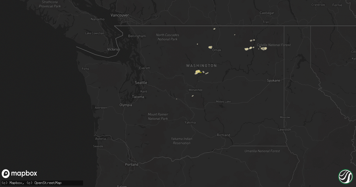
Hail Map in Washington on May 29, 2015
Get this storm
May 29 map
$229
one time, instant access
Download today. No call, no setup
Keep the $229
Bought the map and want the full workflow? Apply the entire $229 to a subscription within 7 days. None of it is wasted.
Every map, not just this one
This buys you this map. Subscription and you get every map we run, in the markets you choose from a few cities to whole states to nationwide. Plus real-time alerts the moment a storm fires.
Contact data
Name, contact info, occupancy, even credit band for addresses in the footprint. You go from where it hit to who to call.
Become the source they trust
Unlimited branding weather history reports on demand. You already have the documented answer ready for the property owner, and you are the one who showed up with it.
Property data and RoofTrace estimates
Pull up any address you have got, its value and the exact code rules for that jurisdiction, straight from One Click Code. Then RoofTrace estimates the squares, pitch, and roof value, priced the way you price.
Storm reports in Washington
Washington
| Date | Description |
|---|---|
| 05/29/20155:30 PM CDT | Delayed report |
| 05/29/20155:12 PM CDT | Hail increased from dimes to quarters. Denting cars in manson area. |
| 05/28/201511:00 PM CDT | Inland power reports 400 homes witout power. |
| 05/28/201510:35 PM CDT | 1000 without power...avista north-central spokane. |
| 05/28/201510:18 PM CDT | Tree branch on power line at 9 mile road and francis producing smoke. Branch size unknown. |
| 05/28/201510:10 PM CDT | Trees down in the fairwood area per public report. |
| 05/28/201510:00 PM CDT | Multiple trees down. Destroyed two parked cars in driveway of home. Tree also clipped and damaged eave of roof. Time estimated based on radar. |
| 05/28/20158:53 PM CDT | Numerous cars damaged when large hail combined with gusty thunderstorm winds. Specific damage unknown. |
All States Impacted by Hail Map on May 29, 2015
Cities Impacted by Hail Map on May 29, 2015
- Hamlin, TX
- Hubbard, TX
- Guide Rock, NE
- Helix, OR
- Pendleton, OR
- Anson, TX
- Aspermont, TX
- Stamford, TX
- Old Glory, TX
- Haskell, TX
- Lueders, TX
- Avoca, TX
- Throckmorton, TX
- Hawley, TX
- Albany, TX
- Rule, TX
- Abilene, TX
- Spotsylvania, VA
- Beulah, CO
- Cranfills Gap, TX
- Clifton, TX
- Jonesboro, TX
- House, NM
- Colville, WA
- Weatherford, TX
- Rosston, AR
- Waldo, AR
- Trementina, NM
- Conchas Dam, NM
- Garita, NM
- North Platte, NE
- Dickens, NE
- Wellfleet, NE
- Wallace, NE
- Glasco, KS
- Delphos, KS
- Snyder, TX
- Wray, CO
- Saint Francis, KS
- Chelan, WA
- Kermit, TX
- Jal, NM
- Fredericksburg, VA
- Tullos, LA
- Olla, LA
- Whitney, TX
- Blum, TX
- Breckenridge, TX
- Inchelium, WA
- Lebanon, KS
- Kensington, KS
- Smith Center, KS
- Athol, KS
- Powhatan, VA
- Entiat, WA
- Manson, WA
- Milnesand, NM
- Tatum, NM
- Pep, NM
- Crossroads, NM
- Riverside, WA
- Graford, TX
- Roswell, NM
- Midlothian, TX
- Kettle Falls, WA
- Republic, KS
- Belleville, KS
- Natchitoches, LA
- Natchez, LA
- Sylvester, TX
- Sweetwater, TX
- Roby, TX
- Justin, TX
- Ponder, TX
- Mount Calm, TX
- Axtell, TX
- Waco, TX
- Graham, TX
- Mankato, KS
- Webber, KS
- Munden, KS
- Courtland, KS
- Narka, KS
- Superior, NE
- Burr Oak, KS
- Cuba, KS
- Elida, NM
- Portales, NM
- Pollock, LA
- Perrin, TX
- Jacksboro, TX
- Winthrop, WA
- Riesel, TX
- Walsenburg, CO
- Gaylord, KS
- McGregor, TX
- Lorena, TX
- Lovington, NM
- Cuervo, NM
- Bartley, NE
- Indianola, NE
- Seminole, TX
- Denver City, TX
- Raton, NM
- Dublin, TX
- Brownfield, TX
- Cross Plains, TX
- Bridgeport, TX
- Springlake, TX
- Edison, NE
- Holbrook, NE
- Arapahoe, NE
- Oxford, NE
- Marathon, TX
- Alvord, TX
- Decatur, TX
- Big Spring, TX
- Baird, TX
- Moran, TX
- Mcdonald, NM
- Hobbs, NM
- Cleburne, TX
- Godley, TX
- Keller, TX
- Deville, LA
- Iredell, TX
- Meridian, TX
- Hico, TX
- Andrews, TX
- Okanogan, WA
- Selden, KS
- Granbury, TX
- Cedar, KS
- Portis, KS
- Prescott, AR
- Aledo, TX
- Millsap, TX
- Calhan, CO
- Paradise, TX
- Lake Arthur, NM
- Artesia, NM
- Gurdon, AR
- Dexter, NM
- Hermanville, MS
- Port Gibson, MS
- Pattison, MS
- Fort Worth, TX
- Azle, TX
- Dover, AR
- Lamar, AR
- Beaver City, NE
- Hendley, NE
- Newcastle, TX
- Long Island, KS
- Phillipsburg, KS
- Macomb, MO
- Mansfield, MO
- Lipan, TX
- Taylor, AR
- Boone, CO
- Rhome, TX
- Hayes Center, NE
- Colby, KS
- Levant, KS
- McCook, NE
- Donaldson, AR
- Malvern, AR
- Fort Sumner, NM
- Monroe, LA
- West Monroe, LA
- Cripple Creek, CO
- Florissant, CO
- Marionville, MO
- Aurora, MO
- Arkadelphia, AR
- Ozan, AR
- Washington, AR
- Stephenville, TX
- Kopperl, TX
- Glen Rose, TX
- Morgan, TX
- Walnut Springs, TX
- Newhope, AR
- Hermleigh, TX
- Roscoe, TX
- Mineral Wells, TX
- Addy, WA
- Hot Springs Village, AR
- Hot Springs National Park, AR
- Peyton, CO
- Jonesville, LA
- Stella, MO
- Stark City, MO
- Granby, MO
- Seymour, MO
- Marshfield, MO
- Loomis, WA
- Boyd, TX
- Loving, TX
- Hartville, MO
- Norwood, MO
- Mountain Grove, MO
- Lamesa, TX
- Magnolia, AR
- Lubbock, TX
- Springer, NM
- Desdemona, TX
- Frisco, TX
- Plano, TX
- Voca, TX
- Clyde, TX
- Winnfield, LA
- Gladstone, NM
- Silverton, TX
- Agra, KS
- Iaeger, WV
- Antoine, AR
- Okolona, AR
- Nashville, AR
- Rice, WA
- Sparkman, AR
- Rio Vista, TX
- Cresson, TX
- Tolar, TX
- Grandview, TX
- Covington, TX
- Joshua, TX
- Dierks, AR
- Mosquero, NM
- Campti, LA
- Cle Elum, WA
- Curtis, NE
- Seagraves, TX
- Carlton, TX
- Haslet, TX
- Pueblo, CO
- Wauconda, WA
- Amelia Court House, VA
- Elk Creek, MO
- Willow Springs, MO
- Yukon, MO
- Moody, TX
- Summersville, MO
- Eunice, MO
- Stamps, AR
- Strawn, TX
- Maywood, NE
- Stephens, AR
- Pineville, LA
- Waxahachie, TX
- Maypearl, TX
- Ranger, TX
- Eastland, TX
- Chouteau, OK
- Pryor, OK
- Georgetown, LA
- Exeter, MO
- Cassville, MO
- Chico, TX
- Carthage, AR
- Plain Dealing, LA
- Amity, AR
- Merkel, TX
- Ellensburg, WA
- Red Cloud, NE
- Kelly, LA
- Emerson, AR
- Atlanta, LA
- Waterville, WA
- Orondo, WA
- Cabot, AR
- Elm Mott, TX
- Poolville, TX
- Bee Branch, AR
- Trent, TX
- Lonoke, AR
- Austin, AR
- Olney, TX
- Keene, TX
- Alvarado, TX
- Royse City, TX
- Quinlan, TX
- Lenorah, TX
- Esbon, KS
- Fowler, CO
- Wagon Mound, NM
- Loving, NM
- Marlin, TX
- Eustis, NE
- Bryson, TX
- Jermyn, TX
- Plumerville, AR
- Glen Elder, KS
- Lone Oak, TX
- Palo Pinto, TX
- Santo, TX
- Gordon, TX
- Miltonvale, KS
- Moseley, VA
- Morton, TX
- Lockesburg, AR
- Robeline, LA
- Colfax, LA
- Dry Prong, LA
- Heppner, OR
- Gail, TX
- Union Church, MS
- Downs, KS
- Monterey, LA
- Allen, TX
- Trout, LA
- Clayton, LA
- Waterproof, LA
- Bearden, AR
- Cana, VA
- Ararat, VA
- Mount Airy, NC
- Gordonsville, VA
- Tucumcari, NM
- Mcalister, NM
- Cambridge, NE
- Haddam, KS


